MARYLAND S LAND USE/LAND COVER MAP AND ASSOCIATED ANALYSIS
|
|
|
- Marvin Flynn
- 5 years ago
- Views:
Transcription


1 MARYLAND S LAND USE/LAND COVER MAP AND ASSOCIATED ANALYSIS Maryland Department of Planning Daniel Baldwin Stephanie Martins November 19,
.")
2 PURPOSE The primary purpose of the land use/land cover data set is to provide a generalized view of how developed land has changed throughout the state, primarily capturing the conversion of resource land to development and characterizing the type of development (e.g. low density or high density residential development, commercial, industrial).

3 HISTORY First mapped statewide in 1973 Several iterations throughout the 1980 s and 1990 s Most recent update in 2010
 2002 Land")

4 2010 LAND USE/LAND COVER 2007 NAIP Imagery (National Agriculture Imagery Program) 2002 Land Use/2010 Land Use 2008 Parcel Data Some County reference layers incorporate county input on draft maps

5 MAPPING BASICS The land use database is based on the Anderson Level II classification, a standard classification system used by land planners. Based on the number of housing units per acre, this classification scheme divides developed land into nine developed land use/cover categories Resolution 1:12,000 Minimum mapping unit 5 acres

6 CLASSIFICATION SYSTEM Planning.Maryland.gov Urban Land Uses 11 Low-density residential 12 Medium-density residential 13 High-density residential 14 Commercial 15 Industrial 16 Institutional 17 Extractive 18 Open urban land 191 Large lot subdivision (agriculture) 192 Large lot subdivision (forest) 80 Transportation Barren Land 71 Beaches 72 Bare exposed. 73 Bare ground Agriculture 21 Cropland 22 Pasture 23 Orchards/vineyards/horticulture 24 Feeding operations 241 Feeding operations 242 Agricultural building 25 Row and garden crops Forest 41 Deciduous forest 42 Evergreen forest 43 Mixed forest 44 Brush 50 Water 60 Wetlands

 Forest Open")
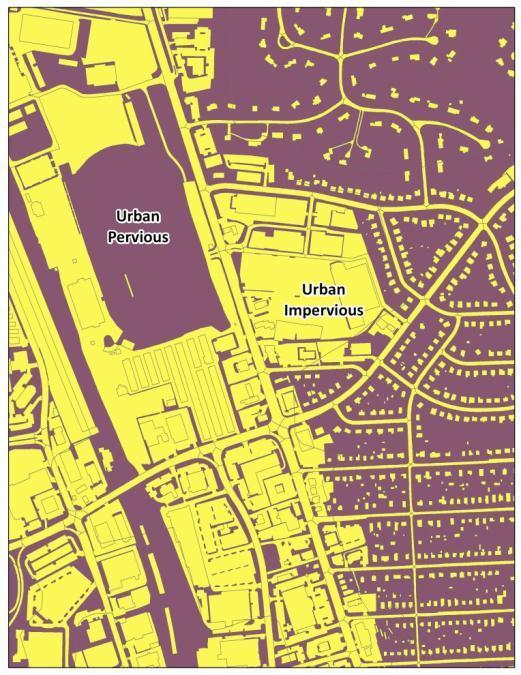
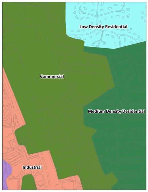
7 LAND USE TYPES Very Low Density Residential High Density Residential Institutional Medium Density Residential Low Density Residential Agriculture Commercial Open Urban Land (Cemetery) Forest Open Urban Land (Golf Course)
.")
) AND(( \"ACRES\" >= 5) AND ( \"ACRES\" < 20)) Low Density= ( \"NFMIMPVL\" > 1000) AND(( \"LU\" = 'R' ) OR ( \"LU\" = 'RC' ) OR ( \"LU\" = 'TH')) AND(( \"ACRES\" >= 0.")
8 MAPPING PROCESS Updated 2002 release of Land Use/Land Cover via visual analysis of 2007 NAIP; and Queried 2008 MDPV points to extract out different land uses (residential, commercial, industrial, institutional). Anderson Level 1 schema Example: Very Low Density = ( "NFMIMPVL" > 1000) AND(( "LU" = 'R' ) OR ( "LU" = 'RC' ) OR( "LU" = 'A' ) OR( "LU" = 'M' ) OR ( "LU" = 'TH')) AND(( "ACRES" >= 5) AND ( "ACRES" < 20)) Low Density= ( "NFMIMPVL" > 1000) AND(( "LU" = 'R' ) OR ( "LU" = 'RC' ) OR ( "LU" = 'TH')) AND(( "ACRES" >= 0.5) AND ( "ACRES" < 5)) Commercial= ( "NFMIMPVL" > 10000) AND(( "LU" = 'C' ) OR ( "LU" = 'CC' ) OR ("LU" = 'CR'))


9 PARCEL QUERIES Planning.Maryland.gov
10 MAPPING RULES For most edits the tax map and parcel layer provided the general shape of the parcel if needed. Developed lands were generally defined as clusters of 5 or more developed parcel points.

11 MAPPING RULES Mapping Very Low Density Residential if > 50% agriculture/open land if > 50% of the parcel is forested 192 Mapping and editing changes were performed at a scale of 1:12, Shoreline and County boundaries not generally adjusted.

12 CAVEATS Changes within the Agriculture and Forest categories were not captured; for example updates were not made to whether forested land is deciduous or evergreen or whether agricultural land is cropland or pasture. This is a Generalized Land Use/Land Cover layer Data are not directly comparable to the previously released 2002 data set.

13 FUTURE PLANS Update around 2015 Working on alternate approaches focusing on data sharing and coordination using NAIP or other high resolution imagery Incorporate local land use/land cover data where available

14 ANALYSIS Planning.Maryland.gov
15
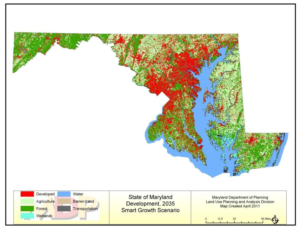
16 2010 Planning.Maryland.gov


17 THE RATE OF DEVELOPMENT IN MARYLAND CONTINUES TO OUTPACE POPULATION GROWTH.


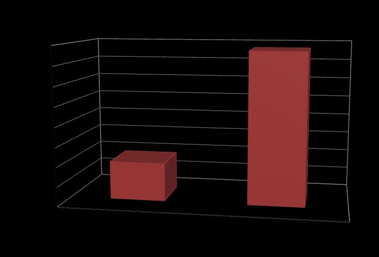
18 THE NUMBER OF DEVELOPED ACRES PER PERSON HAS INCREASED BY MORE THAN 80 PERCENT SINCE Acres Developed Per Person.66 Acres Developed Per Person.50 Acres Developed Per Person


19 LARGE LOT DEVELOPMENT CONTINUES TO DOMINATE OUR LANDSCAPE, COMPRISING MORE THAN HALF OF DEVELOPED LANDS. Planning.Maryland.gov Large lot development has consumed 879,000 acres, roughly half of the total developed land while only accommodating 15 percent of the State s total housing units. This is equivalent to the combined land area of Anne Arundel, Baltimore and Howard counties. Needs to be better incorporated into 2017 model revision.


20 DEVELOPMENT ON SEPTIC SYSTEMS Parcel database Maryland has a statewide parcel database that includes tax assessment information Developed parcels can be selected from that database and related to sewer data Local Sewer Service maps Locals share sewer service area data/maps All improved parcels outside of Existing Sewer Service are assumed to be on septics

21


22 Policy -Growth Print - Ag. Print - Green Print Statewide Impact Analysis Data Input Land Use Holding Capacity Parcels Local Zoning Protected Lands Land Use Model Growth Simulation Model Scenarios -Trends - Smart Growth Transportation VMT Green House Gas Land Preservation Fragmentation Ag. Land Tracking Land Use Water Quality Nutrient Loading Stormwater Runoff Sewer Housing Affordability MDP Analysis Tools Overview
23 2010 Planning.Maryland.gov
24
25


26 MDE GIS DATASETS Planning.Maryland.gov GIS datasets accessible to MDE Collected from local jurisdictions/permitted stormwater entities; varies per local jurisdiction/entity Impervious Cover LULC Storm Drain Systems Outfalls Inlets BMPs BMP Drainage Areas CIPs Right-of-Way
27 IMPERVIOUS COVER DATASETS Planning.Maryland.gov MDE currently has access to the following local impervious cover datasets Phase I MS4s Anne Arundel County Baltimore County Baltimore City Harford County Montgomery County Prince George s County Maryland State Highway Administration Missing data from: Frederick, Carroll, Howard, and Charles Counties. Phase II MS4s and Non-MS4s Worcester County Potentially more counties with available data without required reporting

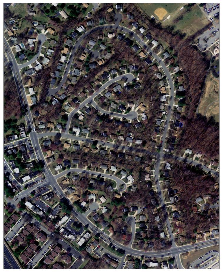
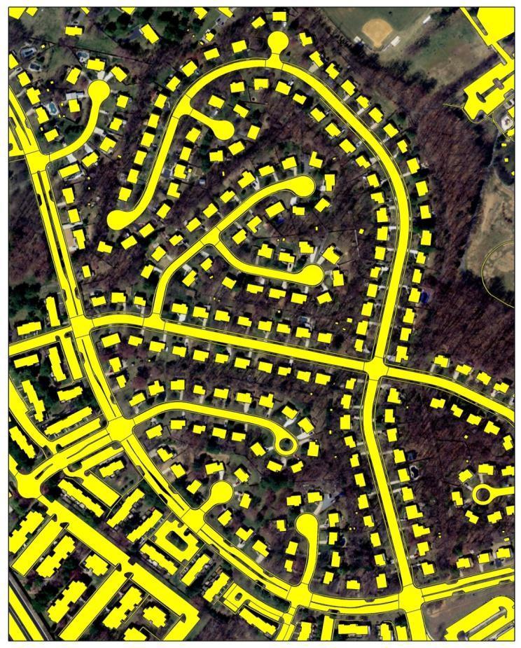
28 MONTGOMERY COUNTY EXAMPLE IMPERVIOUS COVER


29 BALTIMORE COUNTY LU/LC EXAMPLE Planning.Maryland.gov


30 CHARLES COUNTY STORM DRAIN EXAMPLE Planning.Maryland.gov


31 STATE HIGHWAY ADMINISTRATION RIGHT-OF-WAY EXAMPLE

32 POTENTIAL APPLICATIONS Planning.Maryland.gov Land Cover/Land Use Classification Impervious Cover - MDE priority for incorporation into the 2017 model revisionfrom local jurisdictions Local LU/LC Connected vs. Disconnected Impervious Classify based on runoff/drainage type Storm Drain Systems Outfalls Inlets Regulated vs. Non-regulated Classify based on stormwater permits and local data Impervious Cover Storm Drain Systems Right-of-Way

33 QUESTIONS? Planning.Maryland.gov
2011 Land Use/Land Cover Delineation. Meghan Jenkins, GIS Analyst, GISP Jennifer Kinzer, GIS Coordinator, GISP
 2011 Land Use/Land Cover Delineation Meghan Jenkins, GIS Analyst, GISP Jennifer Kinzer, GIS Coordinator, GISP History O Key Points O Based on Anderson s Land Use and Land Cover Classification System O
New Land Cover & Land Use Data for the Chesapeake Bay Watershed
 New Land Cover & Land Use Data for the Chesapeake Bay Watershed Why? The Chesapeake Bay Program (CBP) partnership is in the process of improving and refining the Phase 6 suite of models used to inform
Employment Capacity in Transit Station Areas in Maryland
 Employment Capacity in Transit Station Areas in Maryland Prepared by: The National Center for Smart Growth Research and Education at the University of Maryland* Gerrit Knaap, PhD, Director Terry Moore,
MACo Briefing General Assembly of Maryland
 MACo Briefing General Assembly of Maryland House Environment & Transportation Committee 1/22/2019 Introduction to Maryland Counties Maryland has 23 counties plus Baltimore City (which is legally both a
An Internet-based Agricultural Land Use Trends Visualization System (AgLuT)
") An Internet-based Agricultural Land Use Trends Visualization System (AgLuT) Second half yearly report 01-01-2001-06-30-2001 Prepared for Missouri Department of Natural Resources Missouri Department of
An Internet-based Agricultural Land Use Trends Visualization System (AgLuT) Second half yearly report 01-01-2001-06-30-2001 Prepared for Missouri Department of Natural Resources Missouri Department of
KING GEORGE COUNTY DEPARTMENT OF COMMUNITY DEVELOPMENT
 GIS REPORT 2016 KING GEORGE COUNTY DEPARTMENT OF COMMUNITY DEVELOPMENT Background The GIS (Geographic Information System) coordinator was hired in 2001 to develop a GIS for King George County. Prior to
Link to USGS Phase 6 Land Use Viewer website:
 Chesapeake Bay Program Phase 6 Land Use Review Frequently Asked Questions (FAQ) Link to USGS Phase 6 Land Use Viewer website: http://chesapeake.usgs.gov/phase6/ Sections: 1. Data Review and Production
MS4: MAPPING CHALLENGES. Mike Towle Associate Planner, WestCOG
 MS4: MAPPING CHALLENGES Mike Towle Associate Planner, WestCOG mtowle@westcog.org Please contact or attribute author before using any images or data from this presentation Overview I. Theory and background
Who has the data? Results of Maryland s 3-Week Statewide GIS Inventory Challenge. This is your state. This is your inventory.
 Who has the data? Results of Maryland s 3-Week Statewide GIS Inventory Challenge This is your state. This is your inventory. Maryland s Need for GIS Inventory Maryland had no central repository for its
Phase 6 Land Use Database version 2
 Phase 6 Land Use Database version 2 Peter Claggett, Fred Irani, Quentin Stubbs, and Renee Thompson. October 5, 2015 Modeling Workgroup Quarterly Annapolis, Maryland U.S. Department of the Interior U.S.
The Road to Data in Baltimore
 Creating a parcel level database from high resolution imagery By Austin Troy and Weiqi Zhou University of Vermont, Rubenstein School of Natural Resources State and local planning agencies are increasingly
Presented by: Bryan Bloch GIS Specialist DNREC Division of Watershed Stewardship
 Presented by: Bryan Bloch GIS Specialist DNREC Division of Watershed Stewardship Bryan Hall, AICP Sussex County Circuit Rider Planner, Office of State Planning Coordination, OMB November 19, 2012 UD Sustainable
Urban Tree Canopy Assessment Purcellville, Virginia
 GLOBAL ECOSYSTEM CENTER www.systemecology.org Urban Tree Canopy Assessment Purcellville, Virginia Table of Contents 1. Project Background 2. Project Goal 3. Assessment Procedure 4. Economic Benefits 5.
Phase 6 Land Use Database version 1
 Phase 6 Land Use Database version 1 Peter Claggett, Fred Irani, Quentin Stubbs, and Renee Thompson. June 11, 2015 Modeling Workgroup Meeting USGS MD-DE-DC Water Science Center U.S. Department of the Interior
CHESAPEAKE BAY PROGRAM LAND USE WORKGROUP
 CHESAPEAKE BAY PROGRAM LAND USE WORKGROUP Face-to-Face Meeting Summary September 7, 2016 10:00AM-3:00PM Meeting Materials: http://www.chesapeakebay.net/calendar/event/23315/ Actions & Decisions: ACTION:
GIS in Community & Regional Planning
 GIS in Community & Regional Planning The The role role of of GIS GIS in in Re-writing the the Zoning Bylaw for for the the City City of of Vernon LandInfo Technologies Presentation Overview The GIS Initiative
LAND COVER IN OHIO S TOWNSHIPS: AN ANALYSIS OF TOWNSHIP LAND COVER AND POPULATION CHANGE
 THE EXURBAN CHANGE PROJECT REPORT NUMBER EX-3: LAND COVER IN OHIO S TOWNSHIPS: AN ANALYSIS OF TOWNSHIP LAND COVER AND POPULATION CHANGE (FEBRUARY 2002) Prepared by: Jason W. Reece Data Manager & GIS Analyst
APPENDIX I: Traffic Forecasting Model and Assumptions
 APPENDIX I: Traffic Forecasting Model and Assumptions Appendix I reports on the assumptions and traffic model specifications that were developed to support the Reaffirmation of the 2040 Long Range Plan.
Proposed Scope of Work Village of Farmingdale Downtown Farmingdale BOA Step 2 BOA Nomination Study / Draft Generic Environmental Impact Statement
 Proposed Scope of Work Village of Farmingdale Downtown Farmingdale BOA Step 2 BOA Nomination Study / Draft Generic Environmental Impact Statement The scope of work that follows incorporates and covers
Los Alamos National Laboratory is operated by the University of California for the United States Department of Energy under contract W-7405-ENG-36.
 LA-UR-01-4549 Los Alamos National Laboratory is operated by the University of California for the United States Department of Energy under contract W-7405-ENG-36. TITLE: Evaluation of Land Use/Land Cover
Criteria for Selection of Land Use/Cover Data for Urban Stormwater Quality Analysis
 Contract Report 548 Criteria for Selection of Land Use/Cover Data for Urban Stormwater Quality Analysis by Ming T. Lee, Ying Ke, and Michael L. Terstriep Office of Surface Water Information and GIS Prepared
SWAMP GIS: A spatial decision support system for predicting and treating stormwater runoff. Michael G. Wing 1 * and Derek Godwin
 Journal of Spatial Hydrology Vol. 11, No. 2 Fall 2011 SWAMP GIS: A spatial decision support system for predicting and treating stormwater runoff Michael G. Wing 1 * and Derek Godwin Abstract SWAMP GIS
Vector Analysis: Farm Land Suitability Analysis in Groton, MA
 Vector Analysis: Farm Land Suitability Analysis in Groton, MA Written by Adrienne Goldsberry, revised by Carolyn Talmadge 10/9/2018 Introduction In this assignment, you will help to identify potentially
Comment Response Document Regarding the Total Maximum Daily Load of Sediment in the Lower Gunpowder Falls Watershed, Baltimore County, Maryland
 Comment Response Document Regarding the Total Maximum Daily Load of Sediment in the Lower Gunpowder Falls Watershed, Baltimore County, Maryland The Maryland Department of the Environment (MDE) has conducted
CONFERENCE PAPER. Modeling the Urbanization Process across Maryland in the Context of Chesapeake Bay Restoration
 CONFERENCE PAPER October 2007 Conference Paper 06 Modeling the Urbanization Process across Maryland in the Context of Chesapeake Bay Restoration Scott J. Goetz, Claire A. Jantz, Charles A. Towe, and Nancy
North Wales PRP for Wissahickon Creek Nutrients
 North Wales PRP for Wissahickon Creek Nutrients July 14, 2017 Revised September 7, 2017 Revised August 9, 2018 Prepared for: North Wales Borough 300 School Street North Wales, PA 19454 Corporate Headquarters
Land Use Methods & Metrics Development Outcome
 Quarterly Progress Meeting November 15, 2018 Land Use Methods & Metrics Development Outcome Peter Claggett, USGS LUWG Coordinator Through the Chesapeake Bay Watershed Agreement, the Chesapeake Bay Program
LOOKING FOR THE RELATIONSHIP BETWEEN SPRAWL AND WATER QUALITY: A CASE STUDY OF GLOUCESTER COUNTY, NJ
 Middle States Geographer, 2006, 39:26-33 LOOKING FOR THE RELATIONSHIP BETWEEN SPRAWL AND WATER QUALITY: A CASE STUDY OF GLOUCESTER COUNTY, NJ Donna Moffett 1 and John Hasse 2 1 Department of Earth and
Huron Creek Watershed 2005 Land Use Map
 Huron Creek Watershed 2005 Land Use Map Created By: Linda Kersten, 12/20/06 Created For: MTU Introduction to GIS Class (FW 5550) The Huron Creek Watershed Advisory Committee Michigan Technological University,
Principals and Elements of Image Interpretation
 Principals and Elements of Image Interpretation 1 Fundamentals of Photographic Interpretation Observation and inference depend on interpreter s training, experience, bias, natural visual and analytical
BIODIVERSITY CONSERVATION HABITAT ANALYSIS
 BIODIVERSITY CONSERVATION HABITAT ANALYSIS A GIS Comparison of Greater Vancouver Regional Habitat Mapping with Township of Langley Local Habitat Mapping Preface This report was made possible through the
Critical Area Mapping Update Project St. Mary s County Town Hall April 8th, :30 p.m.
 Critical Area Mapping Update Project St. Mary s County Town Hall April 8th, 2019 6:30 p.m. Critical Area Commission for the Chesapeake and Atlantic Coastal Bays St. Mary s County What Is the Critical Area
Facts and Findings. Exhibit A-1
 Exhibit A-1 Facts and Findings The county periodically prepares coordinated countywide forecasts for all the cities in the county and the unincorporated area. These forecasts can be used by cities as a
Targeted LiDAR use in Support of In-Office Address Canvassing (IOAC) March 13, 2017 MAPPS, Silver Spring MD
 March 13, 2017 MAPPS, Silver Spring MD") Targeted LiDAR use in Support of In-Office Address Canvassing (IOAC) March 13, 2017 MAPPS, Silver Spring MD Imagery, LiDAR, and Blocks In 2011, the GEO commissioned independent subject matter experts (Jensen,
Targeted LiDAR use in Support of In-Office Address Canvassing (IOAC) March 13, 2017 MAPPS, Silver Spring MD Imagery, LiDAR, and Blocks In 2011, the GEO commissioned independent subject matter experts (Jensen,
NCTCOG Regional GIS Meeting 6-Years and Going Strong. May 15, 2018 hosted by: Tarrant County
 NCTCOG Regional GIS Meeting 6-Years and Going Strong May 15, 2018 hosted by: Tarrant County Woolpert at a Glance 1911 Founded in Dayton, Ohio 25+ Offices across the nation 800+ Global employees 25+ OFFICES
Title: ArcMap: Calculating Soil Areas for Storm Water Pollution Prevention Plans Authors: Brandy Woodcock, Benjamin Byars
 Title: ArcMap: Calculating Soil Areas for Storm Water Pollution Prevention Plans Authors: Brandy Woodcock, Benjamin Byars Introduction Abstract: The use of ArcMap to calculate soil areas for storm water
Land Cover Classification Mapping & its uses for Planning
 Land Cover Classification Mapping & its uses for Planning What is Land Cover Classification Mapping? Examples of an actual product Why use Land Cover Classification Mapping for planning? Possible uses
Continuing Education Course #101 Drainage Design with WinTR-55
 1 of 5 Continuing Education Course #101 Drainage Design with WinTR-55 1. WinTR-55 uses the Kinematic Wave method for calculating storm runoff rates and volumes. 2. According to the Velocity Method, the
Developed new methodologies for mapping and characterizing suburban sprawl in the Northeastern Forests
 Development of Functional Ecological Indicators of Suburban Sprawl for the Northeastern Forest Landscape Principal Investigator: Austin Troy UVM, Rubenstein School of Environment and Natural Resources
APPENDIX I - AREA PLANS
 ROUTE 37 WEST LAND USE PLAN ROUTE 37 WEST LAND USE PLAN Recent land use decisions and development trends have drawn attention to the land within the Route 37 western by-pass area between Route 50 and
Technical Memorandum #2 Future Conditions
 Technical Memorandum #2 Future Conditions To: Dan Farnsworth Transportation Planner Fargo-Moorhead Metro Council of Governments From: Rick Gunderson, PE Josh Hinds PE, PTOE Houston Engineering, Inc. Subject:
An Internet-based Agricultural Land Use Trends Visualization System (AgLuT)
") An Internet-based Agricultural Land Use Trends Visualization System (AgLuT) Prepared for Missouri Department of Natural Resources Missouri Department of Conservation 07-01-2000-12-31-2001 Submitted by
An Internet-based Agricultural Land Use Trends Visualization System (AgLuT) Prepared for Missouri Department of Natural Resources Missouri Department of Conservation 07-01-2000-12-31-2001 Submitted by
Chapter 2: Description of Planning Area
 2020 Facilities Plan Facilities Plan Report Chapter 2: Description of Planning Area 2.1 Introduction This chapter describes Milwaukee Metropolitan Sewerage District s (MMSD) planning area and existing
Chapter 6. Fundamentals of GIS-Based Data Analysis for Decision Support. Table 6.1. Spatial Data Transformations by Geospatial Data Types
 Chapter 6 Fundamentals of GIS-Based Data Analysis for Decision Support FROM: Points Lines Polygons Fields Table 6.1. Spatial Data Transformations by Geospatial Data Types TO: Points Lines Polygons Fields
Maryland State Geographic Information Committee
 MD IMAP 3.0 Next generation of MD imap platform running on Esri s ArcGIS Enterprise Promoting authoritative data sharing among State agencies via Portal for ArcGIS Centralization of GIS infrastructure
A Comprehensive Inventory of the Number of Modified Stream Channels in the State of Minnesota. Data, Information and Knowledge Management.
 A Comprehensive Inventory of the Number of Modified Stream Channels in the State of Minnesota Data, Information and Knowledge Management Glenn Skuta Environmental Analysis and Outcomes Division Minnesota
CHAPTER 1 THE UNITED STATES 2001 NATIONAL LAND COVER DATABASE
 CHAPTER 1 THE UNITED STATES 2001 NATIONAL LAND COVER DATABASE Collin Homer*, Jon Dewitz, Joyce Fry, and Nazmul Hossain *U.S. Geological Survey (USGS) Center for Earth Resources Observation and Science
KING GEORGE COUNTY DEPARTMENT OF COMMUNITY DEVELOPMENT
 GIS REPORT 2017 KING GEORGE COUNTY DEPARTMENT OF COMMUNITY DEVELOPMENT Background The GIS (Geographic Information System) manager was hired in 2001 to develop a GIS for King George County. Prior to 2001,
Sensitivity of AERSURFACE Results to Study Area and Location. Paper 2009-A-127-AWMA
 Sensitivity of AERSURFACE Results to Study Area and Location Paper 2009-A-127-AWMA Prepared by: Anthony J. Schroeder, CCM Senior Consultant George J. Schewe, CCM, QEP Principal Consultant Trinity Consultants
CORPORATION OF THE CITY OF COURTENAY COUNCIL MEETING AGENDA
 CORPORATION OF THE CITY OF COURTENAY COUNCIL MEETING AGENDA DATE: Monday, January 14, 2013 PLACE: City Hall Council Chambers TIME: 4:00 p.m. 1.00 ADOPTION OF MINUTES 1. Adopt January 7, 2013 Regular Council
Regional Growth Strategy Regional Staff Committee
 Regional Growth Strategy Regional Staff Committee June 21, 2018 1 Overview Summary of June Growth Management Policy Board Regional Growth Strategy Objectives Regional Geographies Regional Growth Strategy
THE PERSONAL GEODATABASE AS A BMP
 THE PERSONAL GEODATABASE AS A BMP FOR STORMWATER MANAGEMENT Charlynne T. Smith and Hugh A. Devine Center for Earth Observation, College of Natural Resources, NC State University, Raleigh, NC 27606 ABSTRACT
Stormwater Guidelines and Case Studies. CAHILL ASSOCIATES Environmental Consultants West Chester, PA (610)
") Stormwater Guidelines and Case Studies CAHILL ASSOCIATES Environmental Consultants West Chester, PA (610) 696-4150 www.thcahill.com Goals and Challenges for Manual State Stormwater Policy More Widespread
Stormwater Guidelines and Case Studies CAHILL ASSOCIATES Environmental Consultants West Chester, PA (610) 696-4150 www.thcahill.com Goals and Challenges for Manual State Stormwater Policy More Widespread
Analysis of Change in Land Use around Future Core Transit Corridors: Austin, TX, Eric Porter May 3, 2012
 Analysis of Change in Land Use around Future Core Transit Corridors: Austin, TX, 1990-2006 PROBLEM DEFINITION Eric Porter May 3, 2012 This study examines the change in land use from 1990 to 2006 in the
Introduction. Project Summary In 2014 multiple local Otsego county agencies, Otsego County Soil and Water
 Introduction Project Summary In 2014 multiple local Otsego county agencies, Otsego County Soil and Water Conservation District (SWCD), the Otsego County Planning Department (OPD), and the Otsego County
Satellite Imagery: A Crucial Resource in Stormwater Billing
 Satellite Imagery: A Crucial Resource in Stormwater Billing May 10, 2007 Carl Stearns Engineering Technician Department of Public Works Stormwater Services Division Sean McKnight GIS Coordinator Department
FSUTMS Framework for Integrating Land Use Modeling
 FSUTMS Framework for Integrating Land Use Modeling presented to MTF Data Committee presented by Wade L. White, Whitehouse Group Walter Anderson, Whitehouse Group March 6, 2012 Agenda Background Previous
Opportunities to Improve Ecological Functions of Floodplains and Reduce Flood Risk along Major Rivers in the Puget Sound Basin
 Opportunities to Improve Ecological Functions of Floodplains and Reduce Flood Risk along Major Rivers in the Puget Sound Basin Christopher Konrad, US Geological Survey Tim Beechie, NOAA Fisheries Managing
PPT Slide. Slide 1 of 32. Notes:
 Slide 1 of 32 This presentaion will describe the background of establishing an agricultural district in Westchester County and how GIS was used to map the district. file:///volumes/web/www/ce/conferences/gis%20present/testfarm/sld001.htm[4/6/11
City of Thornton Attn: Tim Semones Development Engineeering 9500 Civic Center Dr. Thornton, CO 80229
 Development Engineering Land Surveying Construction Administration District Services October 20, 2017 City of Thornton Attn: Tim Semones Development Engineeering 9500 Civic Center Dr. Thornton, CO 80229
Examples of How Aerial Imagery Is Used in North Carolina. October 2007
 Examples of How Aerial Imagery Is Used in North Carolina October 2007 Table of Contributors Asheville Stormwater Utility Billing Camden County Tracking Permit Violations on Land Clearings CGIA Delineating
CHESAPEAKE BAY PROGRAM LAND USE WORKGROUP
 CHESAPEAKE BAY PROGRAM LAND USE WORKGROUP Call Summary July 6, 2016 10:00AM-12:00PM Meeting Materials: http://www.chesapeakebay.net/calendar/event/23313/ Actions and Decisions: ACTION: Peter Claggett will
City of Chino Hills General Plan Update 13GPA02 Scoping Meeting. June 4, 2013
 13GPA02 Scoping Meeting June 4, 2013 Every California city must adopt a comprehensive, long-term general plan. The General Plan is the City s constitution or blueprint for its long-range physical development.
Appendix P San Joaquin Valley Greenprint
 Appendix P San Joaquin Valley Greenprint TCAG 2014 Regional Transportation Plan San Joaquin Valley Greenprint Data Supplement for SCS Planning And Impact Assessment 3/25/2013 This document is intended
THURSTON COUNTY COMPREHENSIVE PLAN UPDATE
 THURSTON COUNTY COMPREHENSIVE PLAN UPDATE BOARD OF COUNTY COMMISSIONERS WORK SESSION JUNE 14, 2017 Land Use Natural Resources Transportation Housing Utilities Environment Economic Development Capital Facilities
TREASURE COAST REGIONAL PLANNING COUNCIL M E M O R A N D U M. To: Council Members AGENDA ITEM 4B10
 TREASURE COAST REGIONAL PLANNING COUNCIL M E M O R A N D U M To: Council Members AGENDA ITEM 4B10 From: Date: Subject: Staff December 14, 2018 Council Meeting Local Government Comprehensive Plan Review
ESTIMATING LAND-COVER CHANGE IN RSIM: PROBLEMS AND CONSTRAINTS
 ESTIMATING LAND-COVER CHANGE IN RSIM: PROBLEMS AND CONSTRAINTS Latha Baskaran Virginia Dale Chuck Garten David Vogt Colleen Rizy Rebecca Efroymson Oak Ridge National Laboratory Oak Ridge, TN 37831 baskaranl@ornl.gov
Presented at the 78 th Annual Water Environment Federation Technical Exposition and Conference. Washington, D.C. Oct. 29 Nov. 2, 2005.
 Presented at the 78 th Annual Water Environment Federation Technical Exposition and Conference. Washington, D.C. Oct. 29 Nov. 2, 2005. IMPERVIOUS SURFACES IN URBAN WATERSHEDS Celina Bochis-Micu and Robert
2015 KANSAS LAND COVER PATTERNS PHASE I - FINAL REPORT
 2015 KANSAS LAND COVER PATTERNS PHASE I - FINAL REPORT Kansas Applied Remote Sensing Program Kansas Biological Survey University of Kansas Lawrence, Kansas 66047 January 13, 2017 Report Prepared by: Dana
Use of Remote Sensing and GIS for Wetland, Riparian, and Watershed Assessment, Restoration, and Monitoring
 Use of Remote Sensing and GIS for Wetland, Riparian, and Watershed Assessment, Restoration, and Monitoring Ralph Tiner Wetland Ecologist U.S. Fish & Wildlife Service National Wetlands Inventory Program
Land-use changes in a pro-smart-growth state: Maryland, USA
 Environment and Planning A 2007, volume 39, pages 1457 ^ 1477 DOI:10.1068/a3886 Land-use changes in a pro-smart-growth state: Maryland, USA Qing Shen, Feng Zhang Urban Studies and Planning Program, School
GEOGRAPHIC INFORMATION SYSTEMS
 GEOGRAPHIC INFORMATION SYSTEMS 4-H Round-Up Community Transitions Workshop Daniel Hanselka June 14, 2011 Goals of the Workshop Answer the question: What is GIS? Uses of GIS. Some of the Common Terminology
Figure 0-18: Dendrogeomorphic analysis of streambank erosion and floodplain deposition (from Noe and others, 2015a)
") Appendix 9A: Stream to River During the development of the Phase 6 Watershed Model, multiple methods for determining coefficients were often attempted. In some cases, the methods are averaged or otherwise
Appendix 9A: Stream to River During the development of the Phase 6 Watershed Model, multiple methods for determining coefficients were often attempted. In some cases, the methods are averaged or otherwise
Swedish examples on , and
 Swedish examples on 11.2.1, 11.3.1 and 11.7.1 Marie Haldorson, Director Seminar in Nairobi 7 Dec 2018 SDG Indicator Tests by Countries in Europe GEOSTAT 3: ESS Project with a purpose to guide countries
WELCOME Lake Wabukayne OPEN HOUSE
 WELCOME Lake Wabukayne Sediment Removal Project OPEN HOUSE We are here to: Update you, the community, on recent developments and activities at Lake Wabukayne Present the preferred alternative and receive
Fig 1. Steps in the EcoValue Project
 Assessing the Social and Economic Value of Ecosystem Services in the Northern Forest Region: A Geographic Information System (GIS) Approach to Landscape Valuation Principal Investigator(s): Dr. Matthew
DELINEATE URBAN CATCHMENTS
 DELINEATE URBAN CATCHMENTS Guidance for Creating Catchment Boundaries and Attributes v3.1 July 2017 Guidance for Creating Catchment Boundaries and Attributes Version 3.1 July 2017 Developed by: www.2ndnaturellc.com
Remote Sensing the Urban Landscape
 Remote Sensing the Urban Landscape Urban landscape are composed of a diverse assemblage of materials (concrete, asphalt, metal, plastic, shingles, glass, water, grass, shrubbery, trees, and soil) arranged
Public Transportation Infrastructure Study (PTIS) - 2 nd Technical Advisory Committee Meeting
 - 2 nd Technical Advisory Committee Meeting") Public Transportation Infrastructure Study (PTIS) - 2 nd Technical Advisory Committee Meeting Presentation to: Technical Advisory Committee (TAC) Presented by: and Team July 8th, 2009 Public Transportation
Public Transportation Infrastructure Study (PTIS) - 2 nd Technical Advisory Committee Meeting Presentation to: Technical Advisory Committee (TAC) Presented by: and Team July 8th, 2009 Public Transportation
Chapter 3 - White Oak River Subbasin Includes Bogue Sound and the Newport River
 Chapter 3 - White Oak River Subbasin 03-05-03 Includes Bogue Sound and the Newport River 3.1 Water Quality Overview Subbasin 03-05-03 at a Glance Land and Water Area (sq. mi.) Total area: 228 Land area:
Appendix C. Questionnaire Summary of Responses Geographic Information Systems
 Appendix C Questionnaire Summary of Responses Geographic Information Systems 1. Is your agency using or planning use of GIS for: a. general mapping (e.g. highway routes, political boundaries, etc.) b.
A Change Detection Analysis of Agricultural Land Use from the 1970 s to 2001 in Dane County, Wisconsin and the Relationship to Urban Growth.
 A Change Detection Analysis of Agricultural Land Use from the 1970 s to 2001 in Dane County, Wisconsin and the Relationship to Urban Growth. Travis J. Bare Department of Resource Analysis, Saint Mary s
LOCATED IN INDIAN RIVER COUNTY PREPARED FOR S.J.R.W.M.D. AND F.W.C.D. DECEMBER, 2003 Updated 2007 Updated May 2014 PREPARED BY
 FELLSMERE WATER CONTROL DISTRICT EAST MASTER DRAINAGE PLAN AND STORMWATER HYDROLOGIC ANALYSIS OF THE GRAVITY DRAINAGE SYSTEM LOCATED BETWEEN THE EAST BOUNDARY, LATERAL U, THE MAIN CANAL, AND DITCH 24 LOCATED
GIS at the Purdue Center for Regional Development: Some Examples
 GIS at the Purdue Center for Regional Development: Some Examples Indraneel Kumar SHaPE Brownbag Seminar February 1st, 2008 Regional Development for Local Success GIS Tools ESRI ArcGIS suite (ArcInfo-Workstation)
Urban Mapping and Providing Partner Services Utilizing GIS Presenter: Josh Garver. GISP, Assistant Director;
 Urban Mapping and Providing Partner Services Utilizing GIS Presenter: Josh Garver. GISP, Assistant Director; jgarver@franklinswcd.org What I d Like You to do: Think Spatially Look for Shapes Look for Patterns
Reminder that we update the website: with new information, project updates, etc.
 1 Reminder that we update the website: http://www.njfishandwildlife.com/ensp/connectivity_proj.htm with new information, project updates, etc. regularly. Any suggestions are welcome on how to make the
Maryland Transit Administration (MTA) Bus Accident Mapping and Analysis Application
 Bus Accident Mapping and Analysis Application") Maryland Transit Administration (MTA) Bus Accident Mapping and Analysis Application Ralign Wells, MTA Administrator Bernadette Bridges, MTA Chief Safety Officer Office of Safety, Quality Assurance, and
Maryland Transit Administration (MTA) Bus Accident Mapping and Analysis Application Ralign Wells, MTA Administrator Bernadette Bridges, MTA Chief Safety Officer Office of Safety, Quality Assurance, and
1.1 What is Site Fingerprinting?
 Site Fingerprinting Utilizing GIS/GPS Technology 1.1 What is Site Fingerprinting? Site fingerprinting is a planning tool used to design communities where protection of natural resources is the primary
Southwest LRT Habitat Analysis. May 2016 Southwest LRT Project Technical Report
 Southwest LRT Habitat Analysis Southwest LRT Project Technical Report This page intentionally blank. Executive Summary This technical report describes the habitat analysis that was performed to support
Modelling of the Interaction Between Urban Sprawl and Agricultural Landscape Around Denizli City, Turkey
 Modelling of the Interaction Between Urban Sprawl and Agricultural Landscape Around Denizli City, Turkey Serhat Cengiz, Sevgi Gormus, Şermin Tagil srhtcengiz@gmail.com sevgigormus@gmail.com stagil@balikesir.edu.tr
Hydrogeological Assessment for Part of Lots 2 and 3, Concession 5, Township of Thurlow, County of Hastings 1.0 INTRODUCTION. 1.
 February 10,2017 25506400 Ontario Ltd. Foxboro, ON Attention: Brad Newbatt Re: Hydrogeological Assessment for Part of Lots 2 and 3, Concession 5, Township of Thurlow, County of Hastings 1.0 INTRODUCTION
APPENDIX PHASE 1 GREEN INFRASTRUCTURE FRAMEWORK
 APPENDIX PHASE 1 GREEN INFRASTRUCTURE FRAMEWORK KANSAS MISSOURI CONTENTS A DATA WISHLIST 4 B PRECEDENTS 7 C WORKSHOP MATERIALS 13 D ANALYSIS PROCESS 124 E ATLAS & PLAYBOOK DETAILS 156 F POLICY ANALYSIS
STREUVER FIDELCO CAPPELLI, LLC YONKERS DOWNTOWN DEVELOPMENT PHASE 1. DRAFT ENVIRONMENTAL IMPACT STATEMENT For: PALISADES POINT
 STREUVER FIDELCO CAPPELLI, LLC YONKERS DOWNTOWN DEVELOPMENT PHASE 1 DRAFT ENVIRONMENTAL IMPACT STATEMENT For: PALISADES POINT Prepared by: PAULUS, SOKOLOWSKI & SARTOR STORMWATER MANAGEMENT 1. Methodology
WMS 9.0 Tutorial GSSHA Modeling Basics Infiltration Learn how to add infiltration to your GSSHA model
 v. 9.0 WMS 9.0 Tutorial GSSHA Modeling Basics Infiltration Learn how to add infiltration to your GSSHA model Objectives This workshop builds on the model developed in the previous workshop and shows you
Designing GIS Databases to Support Mapping and Map Production Charlie Frye, ESRI Redlands Aileen Buckley, ESRI Redlands
 Designing GIS Databases to Support Mapping and Map Production Charlie Frye, ESRI Redlands Aileen Buckley, ESRI Redlands 1 Designing GIS Databases to Support Mapping and Map Production Charlie Frye, ESRI
WGIA7 9th July, Noriko KISHIMOTO
 Utilizing Global Map for addressing Climate Change WGIA7 9th July, 2009 Seoul, Republic of Korea Noriko KISHIMOTO n-kishimoto@gsi.go.jp Geographic Survey Institute, JAPAN Outline of the Global Map What
STORMWATER REPORT FRITO LAY SUBDIVISION NO. 3
 STORMWATER REPORT FRITO LAY SUBDIVISION NO. 3 May 2018 STORMWATER REPORT I. Subdivision Data a. The parcel is adjacent to the existing Frito Lay property in Topeka; and the subject plat application encompasses
Summary Description Municipality of Anchorage. Anchorage Coastal Resource Atlas Project
 Summary Description Municipality of Anchorage Anchorage Coastal Resource Atlas Project By: Thede Tobish, MOA Planner; and Charlie Barnwell, MOA GIS Manager Introduction Local governments often struggle
Development and Land Use Change in the Central Potomac River Watershed. Rebecca Posa. GIS for Water Resources, Fall 2014 University of Texas
 Development and Land Use Change in the Central Potomac River Watershed Rebecca Posa GIS for Water Resources, Fall 2014 University of Texas December 5, 2014 Table of Contents I. Introduction and Motivation..4
MANUAL ON THE BSES: LAND USE/LAND COVER
 6. Environment Protection, Management and Engagement 2. Environmental Resources and their Use 5. Human Habitat and Environmental Health 1. Environmental Conditions and Quality 4. Disasters and Extreme