Landuse Dataset Derivation from the Fundamental Base of Geographic Data feasibility study
|
|
|
- Thomasine Knight
- 5 years ago
- Views:
Transcription


1 ZEMĚMĚŘICKÝ ÚŘAD Landuse Dataset Derivation from the Fundamental Base of Geographic Data feasibility study Ing. Pavel Šidlichovský INSPIRE conference
2 Table of Content Why are we even trying to derive LU from geographical data? What is the required result? From what data we want to derive the dataset? How did we approach the problem? How the possible result may look How bad idea it is? 2
3 INSPIRE Implementation in CR Implementation is a responsibility of Ministry of the environment Act No 123/1998 Coll. of the right to environmental information Coordination commitee on INSPIRE (KOVIN) is and advisory body for minister of environment Revision of implementation status in 2016 LU theme is assigned to Ministry for regional development, (no competition for future landuse scheme ) 3
4 LU regulation in Czech republic Czech Forestry Act No. 289/1995 Coll. Water Act No.254/2001 Coll. Act No. 334/1992 Coll., on protection of agricultural land, 183/2006 Coll., on town and country planning and building code (Building Act) Hunting Act No. 449/2001 legal procedures, where state is usually represented by municipalities of lowest order ( 6258) or at best municipalities of 3rd order with extended competencies, (205) Some decisions are registered in Cadastre IF the parcel owner forwards the decision to cadastre 4

5 Municipality spatial plans 5
6 LU vs. LC data specification approach Land Cover and Land Use are, however, related and often combined in practical applications. Data sets combining Land Use and Land Cover often emphasize land use aspects in intensively used areas and land cover aspects in extensively used areas. LU: To accommodate the wide variety of spatial information that is already available on Land Use, the application schemas described in chapter 5 are as open ended as possible. and supports two different systems of classification. First of all there is the Hierarchical INSPIRE Land Use Classification System (HILUCS). This is a new, multilevel, classification system. It will be general enough for the member states to map their specific classification system to the appropriate level of HILUCS. LC: The approach taken by this data specification is instead to allow many different land cover nomenclatures to coexist in the context of INSPIRE. The owners of the various code lists are, however, encouraged to document their code lists by using ISO Standard 6
7 HILUCS 3 levels; 98 codevalues overall, split by levels (6,27,65) 1_PrimaryProduction 1_1_Agriculture 1_2_Forestry 1_3_MiningAndQuarrying???? 1_4_AquacultureAndFishing n.d. 1_5_OtherPrimaryProduction n.d. 2_SecondaryProduction 2_1_RawIndustry n.d. 2_2_HeavyEndProductIndustry n.d. 2_3_LightEndProductIndustry n.d. 2_4_EnergyProduction n.d. 2_5_OtherIndustry n.d. 3_TertiaryProduction 4_TransportNetworksLogisticsAndUtilities 5_ResidentialUse 6_OtherUses 7

8 ZABAGED Fundamental base of geographic data of CR Origin in 1995, vectorized base maps 1: Inherited clasification Finished 4th updating cycle Improved accuracy, enhanced atributation 117 published feature types 16 mil. individual object representations ~111 mil. vertexes
9 Matching table AREÁL ÚČELOVÉ ZÁSTAVBY Plocha 211 výstaviště ANO 3 4 Terciární produkce AREÁL ÚČELOVÉ ZÁSTAVBY 1.27 AREÁL ÚČELOVÉ ZÁSTAVBY Plocha 301 sportovní areál 302 plavecký areál 303 stadión 304 dostihový areál, parkur 305 auto moto cyklo areál 306 golfový areál 307 střelnice 308 plochy pro SLZ 309 koupaliště 311 hřiště 314 kynologické cvičiště ANO Terciární produkce 310 camping ANO Terciární produkce 313 rekreační zástavba Plocha 312 chatová kolonie ANO Terciární produkce AREÁL ÚČELOVÉ ZÁSTAVBY 1.27 AREÁL ÚČELOVÉ ZÁSTAVBY 1.27 AREÁL ÚČELOVÉ ZÁSTAVBY Plocha 401 sklad, hangár VĚTŠINOU 4 2 Dopravní sítě, logistika a inženýrské sítě Plocha 402 přístav ANO Dopravní sítě, logistika a inženýrské sítě Plocha 403 depo ANO 4 1 Dopravní sítě, logistika a inženýrské sítě Nelze zcela zaručit že samostatně klasifikovaný skladový areál není spojen s výrobním odvětvím, ZABAGED toto hledisko nerozlišuje. Analýzou by pravděpodobně bylo možno depa následně rozlišit mezi kolejovou a silniční dopravu
10 Matching table results 80 lines (feature attribute value combinantions) with area representation were considered First run: 64 feature attribute combinations could be assigned to HILUC values (covering just 4% of the area) BE MORE BRAVE!!! Second try: Forests, Permanent grass, Arable and other, and Orchards and gardens although ambiguous, were included, improving the coverage to 97% of the state area Remaining unclasified: waters, other industry

11 LU WMS service 11
 special purpose forests I.zones of national parks, recreation forests, water source protection zones etc.")
12 Forestry act knows three forest types: A) productive forests Difficult classes: Forests B) protective forests: forests in exposed places (ridges, difficult conditions) often pinus mungo C) special purpose forests I.zones of national parks, recreation forests, water source protection zones etc. forest purpose land parcels may have no trees 12

13 Agriculture and other ft. vs. transport areas Only linear representation of communiacations In Agriculture and other areas other includes area of roads and railroads 13

14 Required minimal distance between tracks and standoff distance of other infrastructure from tracks is defined by construction standards. The area of railroad body could be reasonably reconstructed using buffer zones of 4m diameter around individual tracks, while disolving overlapping buffers of multi track railway into single area. Railroads possible solution 14

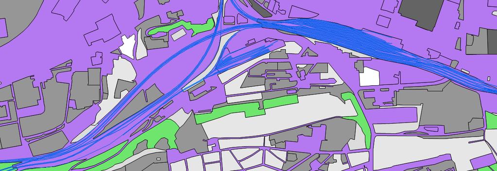
15 Railway area 15


16 Solution for roads image analysis Buffering doesn t really work well, roads are too variable (witdth is not always known) 16

17 Solution for roads assisted vectorization 17
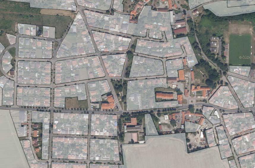


18 Challenges: Residential areas 18

19 Challenges: Residential areas: inner city 19


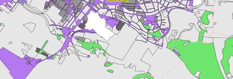
20 Aquaculture: Waters vs. aquaculture vs. comercial fishing Fishponds Bezdrev pond 520 ha, 250 ton of fish yearly 20
21 Conclusions LU with coverage close to 100% area could be produced from geographic data Such dataset would not be, could not be and must not be confused with authoritative data Useful for regional LoD overview of land use Fails in detail, particulary in confrontation with urban spatial planing 21


22 Curent land use vs. Planned land use 22
23 Conclusions LU with coverage close to 100% area could be produced from geographic data Such dataset would not be, could not be and must not be confused with authoritative data Useful for regional LoD overview of land use Fails in detail, particulary in confrontation with urban spatial planing Resulting dataset may be useful for cross checking or reality checking of authoritative data Disclaimer: It s very likely the idea will not be realized as presented 23
24 Thank you for your attention! Pavel Šidlichovský Tel.:
The road to national Inspire-compliant datasets in the Czech republic
 The road to national Inspire-compliant datasets in the Czech republic Ing. Pavel Šidlichovský (Land Survey Office of Czech Republic) INSPIRE 2014; 18.6. Aalborg Overview Directive transposition COSMC and
RESULTS OF DEVELOPMENT AND APPLICATION GEOGRAPHIC INFORMATION STANDARDS IN VIETNAM. Dr. Tran Bach Giang Vietnam
 RESULTS OF DEVELOPMENT AND APPLICATION GEOGRAPHIC INFORMATION STANDARDS IN VIETNAM Dr. Tran Bach Giang Vietnam Shibu lijack Contents 1. BACKGROUND 2. BASIC GEOGRAPHIC INFORMATION STANDARDS (BGIS) Background
INSPIRE Land Cover and Land Use Data Specifications
 INSPIRE Land Cover and Land Use Data Specifications Lena Hallin-Pihlatie Facilitator of the Land Cover and Land Use INSPIRE Thematic Cluster www.jrc.ec.europa.eu Serving society Stimulating innovation
The Governance of Land Use
 The Governance of Land Use Country fact sheet Czech Republic The planning system Levels of government and their responsibilities The Czech Republic is a unitary state with 3 levels of government: the national
The Governance of Land Use
 The planning system Levels of government and their responsibilities The Governance of Land Use COUNTRY FACT SHEET NORWAY Norway is a unitary state with three levels of government; the national level, 19
TOWARDS STRATEGIC SPATIAL PLANNING IN JAMAICA: THE NATIONAL SPATIAL PLAN
 TOWARDS STRATEGIC SPATIAL PLANNING IN JAMAICA: THE NATIONAL SPATIAL PLAN JIEP 5th Biennial Conference on the Environment: Balancing National Development and Environmental Protection June 6, 2011 Jamaica
A Method for Mapping Settlement Area Boundaries in the Greater Golden Horseshoe
 A Method for Mapping Settlement Area Boundaries in the Greater Golden Horseshoe Purpose This paper describes a method for mapping and measuring the lands designated for growth and urban expansion in the
The UN-GGIM: Europe core data initiative to encourage Geographic information supporting Sustainable Development Goals Dominique Laurent, France
 INSPIRE conference Strasbourg 6 September 2017 The UN-GGIM: Europe core data initiative to encourage Geographic information supporting Sustainable Development Goals Dominique Laurent, France Introduction
Turkey s National SDI Implementation
 Onur PAŞAOĞULLARI Head of Department Turkey s National SDI Implementation Presentation Plan NSDI Background General Directorate of Geographic Information Systems NSDI Project INSPIRE Directive Urban Information
Swedish examples on , and
 Swedish examples on 11.2.1, 11.3.1 and 11.7.1 Marie Haldorson, Director Seminar in Nairobi 7 Dec 2018 SDG Indicator Tests by Countries in Europe GEOSTAT 3: ESS Project with a purpose to guide countries
Summary Description Municipality of Anchorage. Anchorage Coastal Resource Atlas Project
 Summary Description Municipality of Anchorage Anchorage Coastal Resource Atlas Project By: Thede Tobish, MOA Planner; and Charlie Barnwell, MOA GIS Manager Introduction Local governments often struggle
INSPIRE Thematic Cluster on Land Cover and Land Use & Feedback from implementers
 INSPIRE Thematic Cluster on Land Cover and Land Use & Feedback from implementers Lena Hallin-Pihlatie Facilitator of the LC and LU Thematic Cluster www.jrc.ec.europa.eu Serving society Stimulating innovation
Demonstration of a local SDI solution with several stakeholders in pilot areas in line with EU best practices
 EU Twinning project for the Agency of Land Relations and Cadaster (ALRC)- Organization, Streamlining and Computerization Process in Mapping in the Republic of Moldova. Demonstration of a local SDI solution
Work Group A «Core Data» Report and Update François Chirié, Dominique Laurent, France
 JOINT UN-GGIM: EUROPE ESS MEETING ON THE INTEGRATION OF STATISTICAL AND GEOSPATIAL INFORMATION LUXEMBOURG 11 MARCH 2016 Work Group A «Core Data» Report and Update François Chirié, Dominique Laurent, France
IR Requirement Article 14 Portrayal
 11 Portrayal This clause defines the rules for layers and styles to be used for portrayal of the spatial object types defined for this theme. Portrayal is regulated in Article 14 of the IRs. IR Requirement
Sustainable Cities and Communities based on Indicators on Urbanization 地理国情监测技术. Prof. Dr. John W. Z. SHI The Hong Kong Polytechnic University
 IAEG- SDGs WG on Geospatial Information, 1 st Expert Group Meeting 12-14 Dec 2016 Mexico City Measure 地理国情监测技术 Sustainable Cities and Communities 专业 based on Indicators on Urbanization Prof. Dr. John W.
Norwegian spatial data infrastructure supporting disaster risk management Norwegian Mapping Authority
 Norwegian spatial data infrastructure supporting disaster risk management Norwegian Mapping Authority Arvid Lillethun, Norwegian Mapping Authority Land and Poverty 2018 Conference, World Bank 19.-23. March
Appropriation Directions for 2007
 INSPIRE in Sweden An Important Part of the National Geodata Strategy Monica Lagerqvist Nilsson Appropriation Directions for 2007 A commission to investigate the necessity to adjust the Swedish legislation
HydroSpatial II Practical application of INSPIRE in Marine Mapping Data
 HydroSpatial II Practical application of INSPIRE in Marine Mapping Data INSPIRE Conference 30 th June 2011 Carlos Berná Esteban, GIS Analyst, SeaZone carlos.berna-esteban@seazone.com Overview HydroSpatial
Fundamental Base of Topographic Data of Czech Land Survey Office as a Source for Database Cartography and other applications.
 Fundamental Base of Topographic Data of Czech Land Survey Office as a Source for Database Cartography and other applications. Pavel Šidlichovský, Head of ZABAGED Administration Section Zeměměřický úřad
SDI Development in Georgia. Mari Khardziani Head of International Relations Unit National Agency of Public Registry
 SDI Development in Georgia Mari Khardziani Head of International Relations Unit National Agency of Public Registry Kehl, Germany September 5, 2017 2 National Agency of Public Registry Legal Entity of Public
OFFICIAL GAZETTE OF THE REPUBLIC OF KOSOVA / No. 30 / 23 AUGUST 2013, PRISTINA LAW NO. 04/L-174 ON SPATIAL PLANNING LAW ON SPATIAL PLANNING
 OFFICIAL GAZETTE OF THE REPUBLIC OF KOSOVA / No. 30 / 23 AUGUST 2013, PRISTINA LAW NO. 04/L-174 ON SPATIAL PLANNING Assembly of Republic of Kosovo; Pursuant to Article 65 (1) of the Constitution of Republic
MARYLAND S LAND USE/LAND COVER MAP AND ASSOCIATED ANALYSIS
 MARYLAND S LAND USE/LAND COVER MAP AND ASSOCIATED ANALYSIS Maryland Department of Planning Daniel Baldwin Stephanie Martins November 19, 2012 http://www.planning.maryland.gov/ PURPOSE The primary purpose
INSPIRE - A Legal framework for environmental and land administration data in Europe
 INSPIRE - A Legal framework for environmental and land administration data in Europe Dr. Markus Seifert Bavarian Administration for Surveying and Cadastre Head of the SDI Office Bavaria Delegate of Germany
Standardization of the land cover classes using FAO Land Cover Classification System (LCCS)
") Sofia, 17-18 September 2008, LPIS Workshop LPIS applications and quality 1 Standardization of the land cover classes using FAO Land Cover Classification System (LCCS) Pavel MILENOV Agriculture Unit, JRC
Sofia, 17-18 September 2008, LPIS Workshop LPIS applications and quality 1 Standardization of the land cover classes using FAO Land Cover Classification System (LCCS) Pavel MILENOV Agriculture Unit, JRC
INSPIRE implementation in the Turkish Ministry of Environment and Urbanization Producing and Publishing Environmental Data
 INSPIRE implementation in the Turkish Ministry of Environment and Urbanization Producing and Publishing Environmental Data Ezgi Sarmusak Urban Planner, MoEU Sibel Süer Toybıyık - Assistant Expert, MoEU
Project based approach developing National Spatial Data Infrastructure in Lithuania
 Project based approach developing National Spatial Data Infrastructure in Lithuania National Land Service under the Ministry of Agriculture of The Republic of Lithuania Cadastres & Geodesy Department Director
INSPIRATION results and benefits for the Agency for Real Estate Cadastre
 JOINT RESEARCH CENTER - E&I WORKSHOP INSPIRATION results and benefits for the Agency for Real Estate Cadastre Sonja Dimova, state advisor AGENCY FOR REAL ESTATE CADASTRE REPUBLIC OF MACEDONIA Wednesday,
Land Use of the Geographical Information System (GIS) and Mathematical Models in Planning Urban Parks & Green Spaces
 and Mathematical Models in Planning Urban Parks & Green Spaces") Land Use of the Geographical Information System (GIS) and Mathematical Models in Planning Urban Key words: SUMMARY TS 37 Spatial Development Infrastructure Linkages with Urban Planning and Infrastructure
Land Use of the Geographical Information System (GIS) and Mathematical Models in Planning Urban Key words: SUMMARY TS 37 Spatial Development Infrastructure Linkages with Urban Planning and Infrastructure
a national geological survey perspective François ROBIDA BRGM (French Geological Survey)
") a national geological survey perspective François ROBIDA BRGM (French Geological Survey) Pre-Conference Seminar on Socio-Economic Value of Geospatial for National and Regional Development 21 August 2017,
a national geological survey perspective François ROBIDA BRGM (French Geological Survey) Pre-Conference Seminar on Socio-Economic Value of Geospatial for National and Regional Development 21 August 2017,
Presented at the FIG Congress 2018, May 6-11, 2018 in Istanbul, Turkey
 Presented at the FIG Congress 2018, May 6-11, 2018 in Istanbul, Turkey INVESTIGATION OF THE SPATIAL ADDRESS RECORDING SYSTEM (SARS) PROJECT PROCESS TO BE BASE THE URBAN INFORMATION SYSTEM 1 FANİSE USLU,
THE IMPACT OF LANDSLIDE AREAS ON MUNICIPAL SPATIAL PLANNING
 THE IMPACT OF LANDSLIDE AREAS ON MUNICIPAL SPATIAL PLANNING Jarosław Bydłosz, PhD Faculty of Mining Surveying and Environmental Engineering AGH University of Science and Technology e-mail: bydlosz@agh.edu.pl
Zagreb Spatial Data Infrastructure. Sanja Batić, APIS IT Split, 14. rujna 2011.
 Zagreb Spatial Data Infrastructure Sanja Batić, APIS IT Split, 14. rujna 2011. Agenda Zagreb Spatial Data Infrastructure - ZIPP Guidelines for further ZIPP Geoportal development Conclusion 1964 The Centre
The Governance of Land Use
 The Governance of Land Use COUNTRY FACT SHEET SPAIN The planning system Levels of government and their responsibilities Spain is defined by the OECD as a quasi-federal state with 4 levels of government;
Law on Spatial Planning
 UNITED NATIONS United Nations Interim Administration Mission in Kosovo UNMIK NATIONS UNIES Mission d Administration Intérimaire des Nations Unies au Kosovo PROVISIONAL INSTITUTIONS OF SELF GOVERNMENT Law
INSPIRing Geospatial Framework For Local Administrations
 This project is financed by the European Union and the Republic of Turkey Presented at the FIG Congress 2018, May 6-11, 2018 in Istanbul, Turkey National Programme for Turkey 2010 Instrument for Pre-Accession
Global Geospatial Information Management Country Report Finland. Submitted by Director General Jarmo Ratia, National Land Survey
 Global Geospatial Information Management Country Report Finland Submitted by Director General Jarmo Ratia, National Land Survey Global Geospatial Information Management Country Report Finland Background
Statistical-geospatial integration - The example of Sweden. Marie Haldorson Director, Statistics Sweden
 Statistical-geospatial integration - The example of Sweden Marie Haldorson Director, Statistics Sweden Spatial data and geospatial applications at Statistics Sweden Long tradition GI integrated in production
INSPIRE Implementation in Estonia using ArcGIS
 INSPIRE Implementation in Estonia using ArcGIS Sulev Õitspuu Head of Bureau of Geoinfosystems Estonian Land Board 26.09.2016 Population: 1,3 million (69% Estonians) Area: 45,339 km 2 15 counties Estonia
Los Alamos Planning Advisory Committee. Stephen Peterson March 19, 2007
 Los Alamos Planning Advisory Committee Stephen Peterson March 19, 2007 What makes Los Alamos so special? Very small, compact town surrounded by large parcel working agriculture and open space areas Old
Influence of INSPIRE on European/national data specifications
 www.eurogeographics.org Influence of INSPIRE on European/national data specifications Saulius Urbanas, EuroGeographics 20 th June 2017 Copyright 2013 EuroGeographics EuroGeographics 46 European countries
The state-of-the-art of the Finnish SDI. Arctic SDI WG Meeting
 The state-of-the-art of the Finnish SDI Arctic SDI WG Meeting Moscow 8.9.2011 Esa Tiainen Development Centre 1 NATIONAL LAND SURVEY DOWN TO EARTH Contents Legal framework Coordination structure Network
Spatial analysis of locational conflicts
 Spatial analysis of locational conflicts Case study: Locational conflicts generated by the expansion of built up surfaces in the northern area of Bucharest, Romania Diana A. ONOSE 1, Cristian I. IOJĂ 2,
Status of implementation of the INSPIRE Directive 2016 Country Fiches. COUNTRY FICHE Czech Republic
 Status of implementation of the INSPIRE Directive 2016 Country Fiches COUNTRY FICHE Czech Republic Introduction... 1 1. State of Play... 2 1.1 Coordination... 2 1.2 Functioning and coordination of the
Ministry of ICT of I.R.IRAN
 The ECO 8/6 mill km 2 10 Slamic countries ~330 mill people Oil, Gas, Industries,Tourism 2 Issue transformation in last decade Problem solving needs more integrated approach More interaction &complexity
ArcGIS for INSPIRE. Marten Hogeweg
 ArcGIS for INSPIRE Marten Hogeweg Please Take Our Survey on the App Download the Esri Events app and find your event Select the session you attended Scroll down to find the feedback section Complete answers
GENERATING INSPIRE PLU DATA ON BASE OF THE GERMAN NATIONAL STANDARD XPLANUNG. Dr. Joachim Benner Dr. Kai-Uwe Krause September
 GENERATING INSPIRE PLU DATA ON BASE OF THE GERMAN NATIONAL STANDARD XPLANUNG Dr. Joachim Benner Dr. Kai-Uwe Krause September Introduction city state Hamburg North Sea Hamburg Hamburg as a city state is
GIS in Community & Regional Planning
 GIS in Community & Regional Planning The The role role of of GIS GIS in in Re-writing the the Zoning Bylaw for for the the City City of of Vernon LandInfo Technologies Presentation Overview The GIS Initiative
The Governance of Land Use
 The Governance of Land Use Country fact sheet Austria The planning system Levels of government and their responsibilities Austria is a federal state with three levels of government; the national level,
The Governance of Land Use
 The planning system The Governance of Land Use United Kingdom Levels of government and their responsibilities The United Kingdom is a unitary state with three devolved governments in Northern Ireland,
Estonian Place Names in the National Information System and the Place Names Register *
 UNITED NATIONS Working Paper GROUP OF EXPERTS ON No. 62 GEOGRAPHICAL NAMES Twenty-fifth session Nairobi, 5 12 May 2009 Item 10 of the provisional agenda Activities relating to the Working Group on Toponymic
GEO-INFORMATICS AND SPACE TECHNOLOGY FOR PROPERTIES DIGITAL TAX MAP : CASE STUDY ON LOCAL ADMINISTRATIVE WONG KONG MUNICIPALITY, PHITSANULOK, THAILAND
 GEO-INFORMATICS AND SPACE TECHNOLOGY FOR PROPERTIES DIGITAL TAX MAP : CASE STUDY ON LOCAL ADMINISTRATIVE WONG KONG MUNICIPALITY, PHITSANULOK, THAILAND Vicharn Amarakul Regional Center of Geo-Informatics
Harmonizing at the borders
 Land Survey Office LAND SURVEY OFFICE OF CZECH REPUBLIC Harmonizing at the borders Pavel Šidlichovský IGW/ISPIRE 2015; Lisabon 26.5.2015 State map series: HIC SUNT LEONES ( OR AQUILAS?) www.cuzk.cz 2 INSPIRE
Plan4all (econtentplus project)
") Plan4all (econtentplus project) Karel CHARVAT 1, Tomáš MILDORF 2 1 Help service remote sensing, Ltd., Černoleská 1600, 256 01 Benešov u Prahy, Czech Republic charvat@bnhelp.cz 2 Department of Mathematics
Plan4all (econtentplus project) Karel CHARVAT 1, Tomáš MILDORF 2 1 Help service remote sensing, Ltd., Černoleská 1600, 256 01 Benešov u Prahy, Czech Republic charvat@bnhelp.cz 2 Department of Mathematics
High Resolution Land Use Information by combined Analysis of Digital Landscape Models and Statistical Data Sets. Tobias Krüger Gotthard Meinel
 High Resolution Land Use Information by combined Analysis of Digital Landscape Models and Statistical Data Sets Tobias Krüger Gotthard Meinel Agenda Monitoring approach Input Data Data Processing Output
Implementation of Inspire in Denmark - How we get it flying! Olav Eggers National Survey & Cadastre -Denmark
 Implementation of Inspire in Denmark - How we get it flying! Olav Eggers oe@kms.dk National Survey & Cadastre -Denmark Introduction Overview Infrastructure for Spatial Information Act National Survey and
The Governance of Land Use
 The planning system Levels of government and their responsibilities The Governance of Land Use Country fact sheet Germany Germany is a federal country with four levels of government. Below the national
Public Transportation Infrastructure Study (PTIS) - 2 nd Technical Advisory Committee Meeting
 - 2 nd Technical Advisory Committee Meeting") Public Transportation Infrastructure Study (PTIS) - 2 nd Technical Advisory Committee Meeting Presentation to: Technical Advisory Committee (TAC) Presented by: and Team July 8th, 2009 Public Transportation
Public Transportation Infrastructure Study (PTIS) - 2 nd Technical Advisory Committee Meeting Presentation to: Technical Advisory Committee (TAC) Presented by: and Team July 8th, 2009 Public Transportation
Valuation of environmental amenities in urban land price: A case study in the Ulaanbaatar city, Mongolia
 1989 1990 1991 1992 1993 1994 1995 1996 1997 1998 1999 2000 2001 2002 2003 2004 2005 2006 2007 2008 2009 2010 2011 Population Valuation of environmental amenities in urban land price: A case study in the
ESBN. Working Group on INSPIRE
 ESBN Working Group on INSPIRE by Marc Van Liedekerke, Endre Dobos and Paul Smits behalf of the WG members WG participants Marc Van Liedekerke Panos Panagos Borut Vrščaj Ivana Kovacikova Erik Obersteiner
Paloma Abad LÓPEZ, Emilio; SÁNCHEZ, Alejandra; RODRÍGUEZ, Antonio F; SOTERES, Carolina. September 17
 Paloma Abad LÓPEZ, Emilio; SÁNCHEZ, Alejandra; RODRÍGUEZ, Antonio F; SOTERES, Carolina 1 We know Directive 2007/2/EC requires Member States to monitor the implementation and use of their infrastructures
Pilot studies on the provision of harmonized land use/land cover statistics: Synergies between LUCAS and the national systems
 1 Pilot studies on the provision of harmonized land use/land cover statistics: Synergies between LUCAS and the national systems Norway Erik Engelien Division for Natural resources and Environmental Statistics,
SITMUN: Cooperating to Build Local SDIs in the Barcelona Region
 SITMUN: Cooperating to Build Local SDIs in the Barcelona Region Diputació de Barcelona Territory and Sustainability Area Territorial Information Systems Department INSPIRE CONFERENCE Barcelona, September
State initiative following up the 2006 national planning report
 18 ness districts and public institutions, should be integrated with the opportunities for public transport services. State initiative following up the 2006 national planning report The Ministry of the
Case study: Nairobi City County CBD and its Environs. Presenter: Peter Patrick Kioko. Supervisor: Mr. B.M. Okumu
 Case study: Nairobi City County CBD and its Environs Presenter: Peter Patrick Kioko Supervisor: Mr. B.M. Okumu OUTLINE Introduction Problem Statement Objectives Area of study Application of GIS Methodology
Land Use Planning and Agriculture: Austrian Experiences and Challenges I
 Land Use Planning and Agriculture: Austrian Experiences and Challenges I SULANET Summer School 2016 Walter Seher BOKU Vienna 1 Land Use Planning and Agriculture 2 Land Use Planning and Agriculture Agriculture
National Regional Development and Spatial Planning Information System (TeIR)
") National Regional Development and Spatial Planning Information System (TeIR) VÁTI Hungarian Public Nonprofit Limited Liability Company for Regional Development and Town Planning 2010. 03. 09. National
National Regional Development and Spatial Planning Information System (TeIR) VÁTI Hungarian Public Nonprofit Limited Liability Company for Regional Development and Town Planning 2010. 03. 09. National
The contribution of EUREF to Inspire
 EUREF2010 SYMPOSIUM The contribution of EUREF to Inspire J. Torres, V. Bitenc, A. Caporali, P. Cruddace, L. Engberg, B. Garayt and H. Habrich (members of TWG-RS) June 2-4, 2010 Gävle 1 EUREF2010 SYMPOSIUM
Turkey National Report
 UNITED NATIONS Working Paper GROUP OF EXPERTS ON No. 26 GEOGRAPHICAL NAMES Twenty-third Session Vienna, 28 March 4 April 2006 Item 5 of the Provisional Agenda: Reports of the division Turkey National Report
Land Use in the context of sustainable, smart and inclusive growth
 Land Use in the context of sustainable, smart and inclusive growth François Salgé Ministry of sustainable development France facilitator EUROGI vice president AFIGéO board member 1 Introduction e-content+
Modelling of the Interaction Between Urban Sprawl and Agricultural Landscape Around Denizli City, Turkey
 Modelling of the Interaction Between Urban Sprawl and Agricultural Landscape Around Denizli City, Turkey Serhat Cengiz, Sevgi Gormus, Şermin Tagil srhtcengiz@gmail.com sevgigormus@gmail.com stagil@balikesir.edu.tr
UNOFFICIAL TRANSLATION
 UNOFFICIAL TRANSLATION THE CROATIAN PARLIAMENT 1135 Pursuant to Article 89 of the Constitution of the Republic of Croatia, I hereby issue the DECISION PROMULGATING THE NATIONAL SPATIAL DATA INFRASTRUCTURE
MANUAL ON THE BSES: LAND USE/LAND COVER
 6. Environment Protection, Management and Engagement 2. Environmental Resources and their Use 5. Human Habitat and Environmental Health 1. Environmental Conditions and Quality 4. Disasters and Extreme
Domain Land Use/Cover Data Model Enabling Multiple Use for Turkey
 Domain Land Use/Cover Data Model Enabling Multiple Use for Turkey Key words: Spatial Data Management, LULC, Land Use/Cover SUMMARY Land use/ land cover (LULC) information, one aspect of GI, has huge important
Ortoimagery and Elevation coverages for INSPIRE. Ing. Pavel Šidlichovský
 ZEMĚMĚŘICKÝ ÚŘAD Ortoimagery and Elevation coverages for INSPIRE Ing. Pavel Šidlichovský INSPIRE conference 2016 Content Description of source data (OI, elevation dataset ) Licenses, prices View service
2011 Land Use/Land Cover Delineation. Meghan Jenkins, GIS Analyst, GISP Jennifer Kinzer, GIS Coordinator, GISP
 2011 Land Use/Land Cover Delineation Meghan Jenkins, GIS Analyst, GISP Jennifer Kinzer, GIS Coordinator, GISP History O Key Points O Based on Anderson s Land Use and Land Cover Classification System O
Comments about the 2014 Agglomeration Land Use and Development Plan, November 17, 2014
 Comments about the 2014 Agglomeration Land Use and Development Plan, November 17, 2014 By Tracey Arial The Agglomeration Land Use and Development Plan is a great opportunity to discuss Montreal s future
SDI Implementation at the Local
 SDI Implementation at the Local Administration Level of Germany Hartmut Müller and Stephan von St. Vith FIG Working Week 2009 Surveyors Key Role in Accelerated Development, Eilat, Israel, 3-8 May 2009
Preparation of Database for Urban Development
 Preparation of Database for Urban Development By PunyaP OLI, 1. Chairman, ERMC (P) Ltd., Kathmandu, Nepal. Email: punyaoli@ermcnepal.com 2. Coordinator, Himalayan College of Geomatic Engineering and Land
GIS Geographical Information Systems. GIS Management
 GIS Geographical Information Systems GIS Management Difficulties on establishing a GIS Funding GIS Determining Project Standards Data Gathering Map Development Recruiting GIS Professionals Educating Staff
EO Information Services. Assessing Vulnerability in the metropolitan area of Rio de Janeiro (Floods & Landslides) Project
 Project") EO Information Services in support of Assessing Vulnerability in the metropolitan area of Rio de Janeiro (Floods & Landslides) Project Ricardo Armas, Critical Software SA Haris Kontoes, ISARS NOA World
EO Information Services in support of Assessing Vulnerability in the metropolitan area of Rio de Janeiro (Floods & Landslides) Project Ricardo Armas, Critical Software SA Haris Kontoes, ISARS NOA World
The Governance of Land Use
 The Governance of Land Use Country fact sheet Poland The planning system Levels of government and their responsibilities Poland has 4 levels of government; the national government, 16 regional governments
THE OVERALL EAGLE CONCEPT
 Sentinel Hub THE OVERALL EAGLE CONCEPT GEBHARD BANKO, 30. MAY 2018, COPENHAGEN ISO TC 211, STANDARDS IN ACTION SEMINAR CONTENT Background and Motivation Criteria and Structure of Data Model Semantic decomposition
Fig. 1: Test area the Municipality of Mali Idjos, Cadastral Municipality Feketic
 Remote Sensing Application for Agricultural Land Value Classification Integrated in the Land Consolidation Survey Stojanka Brankovic, Ljiljana Parezanovic Republic Geodetic Authority, Belgrade, Serbia
EAGLE concept, as part of the HELM vision
 EAGLE concept, as part of the HELM vision EAGLE working group Barbara Kosztra (Hungary), Stephan Arnold (Germany), Lena Hallin-Pihlatie & Elise Järvenpää (Finland) 16.06.2014 HELM / EAGLE Workshop - INSPIRE
Copernicus for Statistics
 Copernicus for Statistics Stephan Arnold Areal statistics, Federal Statistical Office Thomas Wiatr Remote sensing, Federal Agency for Cartography and Geodesy Content Requirements and Setting Eurostat s
Most people used to live like this
 Urbanization Most people used to live like this Increasingly people live like this. For the first time in history, there are now more urban residents than rural residents. Land Cover & Land Use Land cover
Country Report On Sdi Activities In Singapore ( )
") UNITED NATIONS E/CONF.102/IP.4 ECONOMIC AND SOCIAL COUNCIL Nineteenth United Nations Regional Cartographic Conference for Asia and the Pacific Bangkok, 29 October 1 November 2012 Item 6(b) of the provisional
UNITED NATIONS E/CONF.102/IP.4 ECONOMIC AND SOCIAL COUNCIL Nineteenth United Nations Regional Cartographic Conference for Asia and the Pacific Bangkok, 29 October 1 November 2012 Item 6(b) of the provisional
Study Group Theme Comments for Missionary And Lakes: Columbine Meeting 2/22/'05
 Theme Area #: 172 Study Group Theme s for And : Columbine Meeting 2/22/'05 theme 3 would better accommodate existing uses 3 does not seem very limited even though you say it's more natural Consider changing
INSPIRing effort. Peter Parslow Ordnance Survey December Various European approaches to managing an SDI
 INSPIRing effort Peter Parslow Ordnance Survey December 2015 Various European approaches to managing an SDI WHAT IS INSPIRE? A European Union Directive A community effort: http://inspire.ec.europa.eu/
AN OVERVIEW OF SPATIAL DATA INFRASTRUCTURE OF TURKEY WITH A VIEW TO COMPLYING WITH INSPIRE STANDARDS
 AN OVERVIEW OF SPATIAL DATA INFRASTRUCTURE OF TURKEY WITH A VIEW TO COMPLYING WITH INSPIRE STANDARDS Ebru Alarslan Halil Söğüt OUTLINE A Brief History of SDI in Turkey Milestones in the History of SDI
GIS and Governing Anchorage. GIS Critical for Efficient, Transparent Government How is GIS Program Doing Where can GIS Program Take us
 GIS and Governing Anchorage GIS Critical for Efficient, Transparent Government How is GIS Program Doing Where can GIS Program Take us Municipality of Anchorage Office of Economic And Community Development
Developing the GIS-Expert System for Investigating Land Use Designations
 Developing the GIS-Expert System for Investigating Land Use Designations P. Limsupreeyarat a, S. Kaewkeaw b, and P. Charnwasununt c a,b Department of Civil Engineering, Burapha University, Thailand c Department
Report on the establishment of UN GGIM: Europe Item 14. 4th session of the Committee of Experts on UN-GGIM
 Report on the establishment of UN GGIM: Europe Item 14 1 Why regional European committees of UN GGIM? In the ECOSOC resolution 2011/24 on the UN GGIM: Emphasizes the importance of promoting national, regional
Implementation Status & Results Belize Municipal Development (P111928)
") losure Authorized Public Disclosure Authorized Public Disclosure Authorized Public Disclosure Authorized The World Bank Implementation Status & Results Belize Municipal Development (P111928) Operation
losure Authorized Public Disclosure Authorized Public Disclosure Authorized Public Disclosure Authorized The World Bank Implementation Status & Results Belize Municipal Development (P111928) Operation
Transboundary issues in Estonian context
 Transboundary issues in Estonian context Maili Hirlak Estonian Land Board Hamburg 20.01.2016 MSP compilers and timeline Hiiumaa County will be established near future Pärnu county during 2016 Comperhensive
Progress of UN-GGIM: Europe Working Group A on Core Data
 PolicyKEN Budapest 29 November 2016 Progress of UN-GGIM: Europe Working Group A on Core Data François Chirié, Dominique Laurent, IGNF Core data context Background and purpose Aim of Work Group A to propose
Evaluating e-government : implementing GIS services in Municipality
 Evaluating e-government : implementing GIS services in Municipality Municipality of Thessaloniki - G.I.S. Unit Misirloglou Symeon Head of the GIS Unit ESRI UC - 2016 The GIS Section - subset of the department
INTEROPERABILITY AND SPATIAL PLANNING
 INSPIRE Conference 2011 Edimburgh, July 1st, 2011 INTEROPERABILITY AND SPATIAL PLANNING Franco Vico AMFM GIS Italia Flavio Camerata - DipSU, Università Roma Tre European Network of Best Practices for Interoperability
Disaster Management in Republic of Korea
 The Third UN-GGIM-AP Plenary Meeting Disaster Management in Republic of Korea ~Coordination among NGIA & Other Related Organizations and Recommendations~ Bali Indonesia 10 November 2014 Sanghoon Lee, Ph.D.