The ALA in the world of Environmental Consultants
|
|
|
- Morgan Osborne
- 5 years ago
- Views:
Transcription
1 The ALA in the world of Environmental Consultants
2 The ALA in the world of Environmental Consultants or what ever else you want to talk about
3 Our Wish-List A single portal Outcomes in survey and reporting Accurate information Efficient survey and reporting Well informed so we can assist our clients in conserving the significant flora and vegetation within their spheres of influence while developing their projects. (everyone hold hands and sing Kumbaya) Flora Species known from a defined region Commonly encountered species Species with conservation significance Soil types / landform / geology species correlations Aids to identification descriptions, maps, drawings, images, references, keys Vegetation Regional standardized datasets for proportional impact assessment
4 Our Wish-List (2) Imagery Imagery (Satellite, RGB, false colour, high res) Layers Cadastral boundaries (properties / stations) Roads and tracks Tenure Private UCL, VCL Conservation Estate
5 What we commonly use DPaW Database Searches costs levied DRF, Pri species records within a given area PEC, TEC, ESA information Dept. of the Environment Protected Matters search tool Federally listed Threatened Flora Florabase Brief descriptions, maps, images, journal references Specimen records (WA) Useful links to Nuytsia journal articles On-line keys (Keybase) Australia s Virtual Herbarium (AVH) - Open access Specimen records Map with specimen details readily accessed
6 What we commonly use (2) NatureMap Search by Area for a general species list and heads-up on Conservation Significant flora Fauna and Flora combined Link to Florabase is useful More available than we regularly use World Wide Wattle Excellent tool for detail on Acacia Dept of Mines and Petroleum Tengraph Online Tenement boundaries on Google Image Imagery (Landsat, Aster, Spot, Higher Resolution Photography)
7 In Preparation for Field Works Gather information from DPaW on DRF, Pri Flora, however, must review and critically analyze data to remove duplicates and erroneous records. Gather information from DPaW on TEC and PEC, ESA locations Data from DEH Protected Matters search Plot on suitable satellite image with grid using UTM/UPS (metric) at scales of between 1:25,000 to 1:5,000 (need a good CAD service provider)
8 Outputs Species list for project area Vegetation association (?NVIS Level) descriptions and maps with ground-truthed boundaries Species vegetation association correlations List known locations of DRF, Pri species List species that may represent undescribed species Depict all above on maps at suitable readable scale Conduct proportional impact assessment on those species with conservation listing or new species
9 Enigmas, Feelings and Fun Bits

10 Biogeography - IBRA State-wide broad correlations between flora and vegetation with climate, geology and soils Species with widespread distributions Species with disjunct distributions
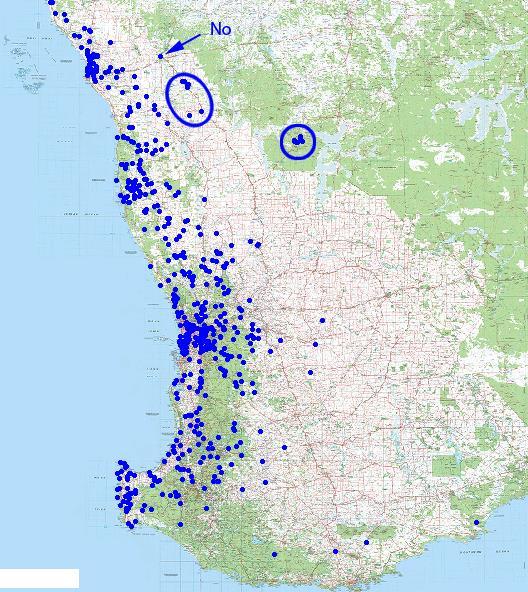
11 Widespread distributions
12 Outliers in the widespread distributions Outlier near Roebourne, Mulga rough black barked tree/shrub to 20 feet may be a mis ID? (i) (ii) (iii) Outlier near Roebourne Geocode error in database Two subspecies recently described, distributions broadly following biogeographic influences What of the others?
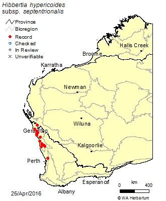
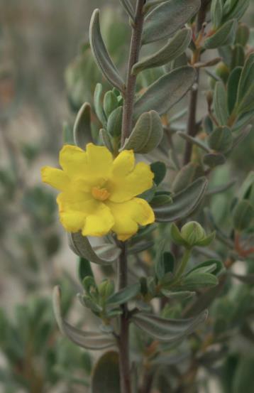
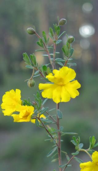
13 Field observations backed up by Biogeographic Influences Hibbertia haemarrhoides

14 Boronia crenulata Disjunct distributions taxonomic variance - WIP


15 Boronia crenulata images Boronia crenulata subsp. Shark Bay P1 is a calcrete outcrop endemic. Big Deal? Calcrete outcrops utilised for quarries, population was threatened with excavation but recognised in the field as likely unusual.


16 Can t be. Eremophila margarethae is generally a species found on shallow sands over granite One previous record of Eremophila margarethae on a BIF range NW of Meekatharra proved to be a new species Eremophila margarethae subsp. straight sepals P1. Interpretation of known habitat and distribution led to it being raised as potentially a new species.

17 Westringia cephalantha complex - WIP W. cephalantha is a shrub to ~1.2m, terminal fls, filiform obtuse leaves, grows on heavier dark red loamy soils in the Avon Wheatbelt BGR. Two subspecies: subsp. cephalantha widespread in the north-western part of the range and subsp. caterva widespread in the south-eastern part of it s range while Occurrences on yellow sandplains on the eastern fringe of the Avon Wheatbelt and into the Gt Victoria Desert appear to be a widespread, distinct taxon, needing taxonomic attention. Yellow Sandplains supporting the as yet undescribed taxon
18 It s all about efficiencies Publicly available databases (ALA and associated sources) are as transformative to us in 2016 as GPS s were back in the mid 1990 s and smart phones and digital photography have become in recent years. Improved efficiencies in recognizing unusual flora through interrogation of maps and collection records greatly improves the opportunity to give clients timely advice, saving money by better targeting our time in the field and improving our taxonomic hit rate. Better outcomes for all.
Technical Guide Flora and Vegetation. Surveys for Environmental Impact Assessment
 Environmental Protection Authority Technical Guide Flora and Vegetation Surveys for Environmental Impact Assessment Technical report of the Environmental Protection Authority and the Department of Parks
Custom Soil Resource Report for Victoria County, Texas
 United States Department of Agriculture Natural Resources Conservation Service A product of the National Cooperative Soil Survey, a joint effort of the United States Department of Agriculture and other
THE USE OF GEOMATICS IN CULTURAL HERITAGE AND ARCHAEOLOGY FOR VARIOUS PURPOSES
 THE USE OF GEOMATICS IN CULTURAL HERITAGE AND ARCHAEOLOGY FOR VARIOUS PURPOSES FEBRUARY 2013 AL BEIDA GEOPLAN CONTENT Company Profile Concept Objectives and Strategies Data Production Methods Data Samples
Biodiversity data use by Regional NRM groups
 Biodiversity data use by Regional NRM groups The Ins; The Outs; and the Ins-and-Outs Richard McLellan CEO, NACC NRM on ALA: Data by NRM Regions ALA has great resources (Australian BioBlitz Guidelines,
climate famous data sharing toolbox in
 This is the story of what was done, and some lessons learnt as we bumped along on a very rough road. In the process of our work in mapping vegetation, modelling to investigate the possible impacts of climate
Mapping granite outcrops in the Western Australian Wheatbelt using Landsat TM data
 Journal of the Royal Society of Western Australia, 109-113, 2000 Mapping granite outcrops in the Western Australian Wheatbelt using Landsat TM data N A Campbell 1, S D Hopper 2 & P A Caccetta 1 1 CSIRO
5/15/ Use of Geographic Information System (GIS) in Grazing Management Muhammad Farooq Hussain Faisal 12-Arid-604 (M.
 in Grazing Management Muhammad Farooq Hussain Faisal 12-Arid-604 (M.") 5/15/218 1 Use of Geographic Information ystem (GI) in Grazing Management Muhammad Farooq Hussain Faisal 12-Arid-64 (M.phill LM) 1 Contents History Back Ground Information Introduction of GI Who use GI?
5/15/218 1 Use of Geographic Information ystem (GI) in Grazing Management Muhammad Farooq Hussain Faisal 12-Arid-64 (M.phill LM) 1 Contents History Back Ground Information Introduction of GI Who use GI?
Australia s leading provider of Satellite Imagery since 1988
 Geoimage offers professional and independent advice on the supply and application of commercially available satellite imagery and spatial datasets. Geoimage is now offering targeted solutions integrating,
Sources of Imagery and GIS Data Layers (Last updated October 2005)
") Sources of Imagery and GIS Data Layers (Last updated October 2005) The question of where to find data is one often asked by beginners in precision agriculture and other geospatial projects. The following
Sources of Imagery and GIS Data Layers (Last updated October 2005) The question of where to find data is one often asked by beginners in precision agriculture and other geospatial projects. The following
indigeo Consultants Pvt Ltd Geophysical Surveys Geological Surveys GIS & Data Solutions Image Processing indigeo Company Profile, Page 1
 indigeo Consultants Pvt Ltd Geophysical Surveys Geological Surveys GIS & Data Solutions Image Processing MM Corner, 3 rd Floor #58, Banaswadi Main Road Bangalore 560033 INDIA Ph: +91 80 41638310 Mob: +91
Looking at the big picture to plan land treatments
 Looking at the big picture to plan land treatments Eva Strand Department of Rangeland Ecology and Management University of Idaho evas@uidaho.edu, http://www.cnr.uidaho.edu/range Why land treatment planning?
Ramani Geosystems. Putting Africa On The Map. Authorized Resellers
 Ramani Geosystems Putting Africa On The Map Authorized Resellers Ramani Profile Started in 1999 Aerial, Land Surveying & Mapping Solutions + 10 Countries in the region + 80 Staff working in projects Asset
Factors that Shape Places Stage 3 Geography
 Factors that Shape Places Stage 3 Geography Summary This unit is written for Stage 3 "Factors that shape places". It is a Geographical Inquiry, enabling students to work through the 3 stages of inquiry;
Geography 3251: Mountain Geography Assignment II: Island Biogeography Theory Assigned: May 22, 2012 Due: May 29, 9 AM
 Names: Geography 3251: Mountain Geography Assignment II: Island Biogeography Theory Assigned: May 22, 2012 Due: May 29, 2012 @ 9 AM NOTE: This lab is a modified version of the Island Biogeography lab that
UTAH S STATEWIDE GEOGRAPHIC INFORMATION DATABASE
 UTAH S STATEWIDE GEOGRAPHIC INFORMATION DATABASE Data Information and Knowledge Management NASCIO Awards 2009 STATE GEOGRAPHIC INFORMATION DATABASE B. EXECUTIVE SUMMARY Utah has developed one of the most
Capturing and recording spatial data Guidelines, standards and best practices
 Capturing and recording spatial data Guidelines, standards and best practices February 2018 Established by Technical Note Author David Taylor, Data4FI, insight2impact About insight2impact Insight2impact
the map Redrawing Donald Hobern takes a look at the challenges of managing biodiversity data [ Feature ]
![the map Redrawing Donald Hobern takes a look at the challenges of managing biodiversity data [ Feature ]](/thumbs/82/86628837.jpg "the map Redrawing Donald Hobern takes a look at the challenges of managing biodiversity data [ Feature ]") Redrawing the map Donald Hobern takes a look at the challenges of managing biodiversity data 46 Volume 12 > Number 9 > 2008 www.asiabiotech.com Cicadetta sp., Canberra, Australia, December 2007 Photograph
Redrawing the map Donald Hobern takes a look at the challenges of managing biodiversity data 46 Volume 12 > Number 9 > 2008 www.asiabiotech.com Cicadetta sp., Canberra, Australia, December 2007 Photograph
Geomap Downloading and changes in New Version
 1 Geomap Downloading and changes in New Version 1.9.10.0 14 June 2014 William O'Connor and Udo Kaschner about-us.html 2 Published by: William O'Connor PO Box 2207 Clarkson Western Australia http://www.gold-prospecting-wa.com
Louisiana Transportation Engineering Conference. Monday, February 12, 2007
 Louisiana Transportation Engineering Conference Monday, February 12, 2007 Agenda Project Background Goal of EIS Why Use GIS? What is GIS? How used on this Project Other site selection tools I-69 Corridor
NR402 GIS Applications in Natural Resources. Lesson 9: Scale and Accuracy
 NR402 GIS Applications in Natural Resources Lesson 9: Scale and Accuracy 1 Map scale Map scale specifies the amount of reduction between the real world and the map The map scale specifies how much the
Fundamental Geospatial Datasets in Africa. Andre Nonguierma New York, 03 August 2015
 Fundamental Geospatial Datasets in Africa United Nations Economic Commission for Africa Geoinformation & Spatial Statistics Andre Nonguierma New York, 03 August 2015 Core Data : Lack of consistency Infrastructure
Local Biodiversity Program
 Local Biodiversity Program 2013 Native vegetation by vegetation complex dataset for the South West of Western Australia 1 Background... 2 2 Native Vegetation Extent by Vegetation Complex... 2 3 Native
GIS = Geographic Information Systems;
 What is GIS GIS = Geographic Information Systems; What Information are we talking about? Information about anything that has a place (e.g. locations of features, address of people) on Earth s surface,
Data Origin. Ron van Lammeren CGI-GIRS 0910
 Data Origin Ron van Lammeren CGI-GIRS 0910 How to obtain geodata? Geo data initiative Executive Order 12906, "Coordinating Geographic Data Acquisition and Access: The National Spatial Data Infrastructure,"
Open Data meets Big Data
 Open Data meets Big Data Max Craglia, Sven Schade, Anders Friis European Commission Joint Research Centre www.jrc.ec.europa.eu Serving society Stimulating innovation Supporting legislation JRC is Technical
Data Origin. How to obtain geodata? Ron van Lammeren CGI-GIRS 0910
 Data Origin How to obtain geodata? Ron van Lammeren CGI-GIRS 0910 Spatial Data interest Improvement of policy making. ± 90% of all information used by government has spatial characteristics SPATIAL INFORMATION
STATE GEOGRAPHIC INFORMATION DATABASE
 STATE GEOGRAPHIC INFORMATION DATABASE Data Information and Knowledge Management STATE GEOGRAPHIC INFORMATION DATABASE EXECUTIVE SUMMARY Utah has developed one of the most comprehensive statewide GIS resources
OUTLINE OF PRESENTATION
 XXIV FIG International Congress 2010 SIDS Workshop, Small Island Developing States and The Millennium Development Goals 14 th and 15 th April 2010, Sydney, Australia. Case Study of the Papua New Guinea
Geological mapwork: using surface geology to make a geological map Match the photos to a map to see how a geological map works
 eological mapwork: using surface geology to make a geological map Match the photos to a map to see how a geological map works For each of the photographs: 1. Draw straight lines to link each photograph
For personal use only
 ASX ANNOUNCEMENT / MEDIA RELEASE ASX:ABU 19th October, 2012 Phase 4: Longitudinal Surface Vein Sampling Extends the Western Limb of Old Pirate with a further 71m strike length from surface vein sampling
Mapping and Modeling for Regional Planning
 Mapping and Modeling for Regional Planning Carol W. Witham Sacramento Valley Chapter California Native Plant Society contributors: David Ackerly John Dittes Julie Evens Josephine Guardino Robert F. Holland
Custom Soil Resource Report. Soil Map. Map projection: Web Mercator Corner coordinates: WGS84 Edge tics: UTM Zone 14N WGS84. Feet.
 Custom Soil Resource Report Soil Map 3188500 3188700 3188900 3189100 3189300 3189500 3189700 96 43' 30'' W 3188500 3188700 3188900 3189100 3189300 3189500 3189700 96 42' 11'' W 28 48' 59'' N 28 48' 59''
A VISIT TO SIX AREAS IN NAMIBIA, HABITAT TO DIFFERENT LITHOPS SPECIES by Tok Schoeman (Photographs by the author unless stated differently)
") A VISIT TO SIX AREAS IN NAMIBIA, HABITAT TO DIFFERENT LITHOPS SPECIES by Tok Schoeman (Photographs by the author unless stated differently) On 29 April 2013, my wife and I, accompanied by Dr Ronald Uijs
A VISIT TO SIX AREAS IN NAMIBIA, HABITAT TO DIFFERENT LITHOPS SPECIES by Tok Schoeman (Photographs by the author unless stated differently) On 29 April 2013, my wife and I, accompanied by Dr Ronald Uijs
REPORT ON COMPILATION OF KIMBERLEY BIODIVERSITY AND NATURAL RESOURCE MANAGEMENT DATA AND ASSOCIATED INFORMATION. T.Handasyde.
 REPORT ON COMPILATION OF KIMBERLEY BIODIVERSITY AND NATURAL RESOURCE MANAGEMENT DATA AND ASSOCIATED INFORMATION. T.Handasyde. Kimberley Regional Fire Management Project, North Australian Fire Project (Developing
Biodiversity Blueprint Overview
 Biodiversity Blueprint Overview Climate Variability Climate projections for the Glenelg Hopkins Regions suggest that the weather will be hotter and drier in the coming years which will impact on land use,
For personal use only
 Kaili Resources Limited (formerly Omnitech Holdings Limited) ABN 39 077 559 525 7 Darley Street, Darlinghurst Sydney NSW 2010, Australia T: +61 2 9267 5988 F: +612 9283 7166 E: contact@kailigroup.com.au
15 March 2010 Re: Draft Native Vegetation of the Sydney Metropolitan Catchment Management Authority Area GIS layers and explanatory reports
 SYDNEY COASTAL COUNCILS GROUP Inc. C/- City of Sydney Council Level 14, 456 Kent Street GPO Box 1591, SYDNEY NSW 2001 Phone: (02) 9246 7791 Facsimile: (02) 9265 9660 Email: info@sydneycoastalcouncils.com.au
Outline. What is MapPlace? MapPlace Toolbar & PopUp Menu. Geology Themes 1:5M 1:1M BCGS 1:250,000. Terranes
 Outline BRITISH COLUMBIA Overview and Explore MapPlace Website Data Delivery & Map Themes Data Sources & Updates Feature Topics New Data & Maps New MINFILE Online Exploration Assistant with Image Analysis
Geology Merit Badge Workbook
 Merit Badge Workbook This workbook can help you but you still need to read the merit badge pamphlet. This Workbook can help you organize your thoughts as you prepare to meet with your merit badge counselor.
Beneath the sand of the Tanami Desert
 Beneath the sand of the Tanami Desert ARGA 2018, Wallaroo, SA Nadir de Souza Kovacs Ngururrpa program The program area covers the traditional land of the Parna Ngururrpa People in a remote part of the
Advanced Algorithms for Geographic Information Systems CPSC 695
 Advanced Algorithms for Geographic Information Systems CPSC 695 Think about Geography What is Geography The 3 W s of Geography What is where Why is it there Why do I care Data - Data - Data We all got
Guidance for implementing the Potential Fossil Yield Classification (PFYC) System
 System") Guidance for implementing the Potential Fossil Yield Classification (PFYC) System Introduction The PFYC system will aid in assessing the potential to discover or impact significant paleontological resources.
Guidance for implementing the Potential Fossil Yield Classification (PFYC) System Introduction The PFYC system will aid in assessing the potential to discover or impact significant paleontological resources.
CRUM RANCH AREA MAP YOLO COUNTY, California, AC +/-
 CRUM RANCH AREA MAP YOLO COUNTY, California, 235.59 AC +/- Map data 2016 Google Imagery 2016, CAPCOG, DigitalGlobe, Texas Orthoimagery Program, U.S. Geological Survey, USDA Farm Service Agency Boundary
Overview of Remote Sensing in Natural Resources Mapping
 Overview of Remote Sensing in Natural Resources Mapping What is remote sensing? Why remote sensing? Examples of remote sensing in natural resources mapping Class goals What is Remote Sensing A remote sensing
Mineral Prospectivity Modelling 2010
 Mineral Prospectivity Modelling 2010 Kenex Ltd, Eastbourne, New Zealand Kenex Pty Ltd, Perth, Western Australia P: +64 4 562 6253 www.kenex.co.nz info@kenex.co.nz P: +61 8 6468 4965 www.kenex.com.au info@kenex.com.au
The Emerging Role of Enterprise GIS in State Forest Agencies
 The Emerging Role of Enterprise GIS in State Forest Agencies Geographic Information System (GIS) A geographic information system (GIS) is a computer software system designed to capture, store, manipulate,
COMMENTS ON THE CONSERVATION STATUS OF SENECIO VELLEIOIDES (FOREST GROUNDSEL) IN TASMANIA
 IN TASMANIA") COMMENTS ON THE CONSERVATION STATUS OF SENECIO VELLEIOIDES (FOREST GROUNDSEL) IN TASMANIA Mark Wapstra Environmental Consulting Options Tasmania, 28 Suncrest Avenue, Lenah Valley, Tasmania 7008; mark@ecotas.com.au
COMMENTS ON THE CONSERVATION STATUS OF SENECIO VELLEIOIDES (FOREST GROUNDSEL) IN TASMANIA Mark Wapstra Environmental Consulting Options Tasmania, 28 Suncrest Avenue, Lenah Valley, Tasmania 7008; mark@ecotas.com.au
1) make sure folks know what s available in terms of geospatial data and resources that could contribute to their decision support toolkits;
 make sure folks know what s available in terms of geospatial data and resources that could contribute to their decision support toolkits;") Introduction 1 2001 It was born out of the recognition that several of the regions prominent resource management agencies have similar, if not shared, requirements for GIS data. Some of the underlying
Introduction 1 2001 It was born out of the recognition that several of the regions prominent resource management agencies have similar, if not shared, requirements for GIS data. Some of the underlying
CAPE FARM MAPPER - an integrated spatial portal
 CAPE FARM MAPPER - an integrated spatial portal Skukuza Dr Mike Wallace June 2017 Overview of GIS applications in WCDoA Spatial information and technology has become indispensable across a wide range of
Overview Objectives Materials Background Activity Procedure
 Overview In this activity, students will explore how to determine how to assemble information about plant distributions, and relate those distributional to the environment by assembling information on
Chapter 6. Field Trip to Sandia Mountains.
 University of New Mexico Biology 310L Principles of Ecology Lab Manual Page -40 Chapter 6. Field Trip to Sandia Mountains. Outline of activities: 1. Travel to Sandia Mountains 2. Collect forest community
RC Drilling Confirms Zeus Gold Prospect
 MEDIA RELEASE 30 September 2008 RC Drilling Confirms Zeus Gold Prospect (Gondwana) is pleased to report that it has identified shallow gold potential at Zeus from its recent program of RC drilling combined
Construction Project Data Management
 Construction Project Data Management Establishing Foundations for an Asset Database Scot Twining Project Activities Supported by GIS Cadastral Mapping Proposed Pipeline Route Selection Right Of Way Acquisition
Nebraska Conservation and Environmental Review Tool (CERT): Terminology used in the Tables of the CERT Report
: Terminology used in the Tables of the CERT Report") Nebraska Conservation and Environmental Review Tool (CERT): Terminology used in the Tables of the CERT Report Nebraska Natural Heritage Program Nebraska Game and Parks Commission February 8, 2018 Contents
Nebraska Conservation and Environmental Review Tool (CERT): Terminology used in the Tables of the CERT Report Nebraska Natural Heritage Program Nebraska Game and Parks Commission February 8, 2018 Contents
Seeking a Balance. Conservation and resource use in the Northern Flinders Ranges. Government of South Australia
 Seeking a Balance Conservation and resource use in the Northern Flinders Ranges Government of South Australia Protecting the values of the Northern Flinders Ranges The Flinders Ranges has some of the
Manitoba s Elevation (LiDAR) & Imagery Datasets. Acquisition Plans & Opportunities for Collaboration
 & Imagery Datasets. Acquisition Plans & Opportunities for Collaboration") Manitoba s Elevation (LiDAR) & Imagery Datasets Acquisition Plans & Opportunities for Collaboration Manitoba Planning Conference May 2017 Presentation Outline Manitoba s Elevation (LiDAR) and Imagery Datasets
Manitoba s Elevation (LiDAR) & Imagery Datasets Acquisition Plans & Opportunities for Collaboration Manitoba Planning Conference May 2017 Presentation Outline Manitoba s Elevation (LiDAR) and Imagery Datasets
National Atlas of Groundwater Dependent Ecosystems (GDE)
") National Atlas of Groundwater Dependent Ecosystems (GDE) Dr. Zaffar Sadiq Mohamed-Ghouse Executive Consultant & Practice Head-Spatial SKM, Australia zsadiq@globalskm.com Geospatial World Forum 2013, Rotterdam,
National Atlas of Groundwater Dependent Ecosystems (GDE) Dr. Zaffar Sadiq Mohamed-Ghouse Executive Consultant & Practice Head-Spatial SKM, Australia zsadiq@globalskm.com Geospatial World Forum 2013, Rotterdam,
Habitat Mapping using Remote Sensing for Green Infrastructure Planning in Anguilla
 Habitat Mapping using Remote Sensing for Green Infrastructure Planning in Anguilla Dr Katie Medcalf Cenv MIEEM www.envsys.co.uk Context Introduction to Anguilla Habitat mapping using Earth Observation
STAGE 2 GEOGRAPHY: Natural environments
 STAGE 2 GEOGRAPHY: Natural environments Focus area: The Earth s environment Different environments Significance of environments Key inquiry questions How does the environment support the lives of people
BOY SCOUTS GEOLOGY MERIT BADGE
 Requirements highlighted in yellow will be covered at the club show. Merit Badge Counselors will be on-hand. Please bring your own paperwork. Children under 12 and scouts in uniform are admitted to the
GEOGRAPHIC INFORMATION SYSTEMS AND IT SOLUTIONS FOR THE ENVIRONMENT
 GEOGRAPHIC INFORMATION SYSTEMS AND IT SOLUTIONS FOR THE ENVIRONMENT Mission We focus on Solutions is a worldwide operating business offering Geographic Information Systems and IT solutions to assist environmental
The Three Things You Need to Know About Tsunami Preparedness Patrick Corcoran, Oregon Sea Grant,
 The Three Things You Need to Know About Tsunami Preparedness Patrick Corcoran, Oregon Sea Grant, 10.11.13 NSF/CEETEP Workshop for Coastal Educators, October 11-14, Astoria, OR The Bottom Line Giant Earthquakes
Technical Drafting, Geographic Information Systems and Computer- Based Cartography
 Technical Drafting, Geographic Information Systems and Computer- Based Cartography Project-Specific and Regional Resource Mapping Services Geographic Information Systems - Spatial Analysis Terrestrial
USE OF RADIOMETRICS IN SOIL SURVEY
 USE OF RADIOMETRICS IN SOIL SURVEY Brian Tunstall 2003 Abstract The objectives and requirements with soil mapping are summarised. The capacities for different methods to address these objectives and requirements
MODERNIZATION OF THE MUNICIPAL MAPPING USING HIGH END GNSS SYSTEM AND GIS SOFTWARE
 MODERNIZATION OF THE MUNICIPAL MAPPING USING HIGH END GNSS SYSTEM AND GIS SOFTWARE Mr. R. A. R. Khan Assistant Engineer, Sewerage Utility Management Centre (SUMC) Municipal Corporation Of Greater Mumbai
GIS. in the City of Lewiston Maine
 GIS in the City of Lewiston Maine The purpose of this slideshow is to provide an overview of the city GIS and how it is used, maintained and accessed in-house as well as by the public. Please simply hit
Innovative Ways to Monitor Land Displacement
 ARTICLE Innovative Ways to Monitor Land Displacement When people think about landslides, they usually imagine large mud streams which cause considerable loss of life. Whereas such large-scale disasters
Chitra Sood, R.M. Bhagat and Vaibhav Kalia Centre for Geo-informatics Research and Training, CSK HPKV, Palampur , HP, India
 APPLICATION OF SPACE TECHNOLOGY AND GIS FOR INVENTORYING, MONITORING & CONSERVATION OF MOUNTAIN BIODIVERSITY WITH SPECIAL REFERENCE TO MEDICINAL PLANTS Chitra Sood, R.M. Bhagat and Vaibhav Kalia Centre
Water Supply System in Ntisaw, Cameroon
 Water Supply System in Ntisaw, Cameroon Garrett Kehoe UNIVERSITY OF TEXAS AT AUSTIN FALL 2013 GIS Contents Project Background... 2 Available and Required Data... 3 Methodology... 3 Results... 8 Future
1. INTRODUCTION ACEPS
 Application of Remote Sensing and GIS techniques for exploring Construction Material from inaccessible terrains; case study in Eastern Province of Sri Lanka H.M.R. Premasiri, H.C.D.P. Colombage, D.Palamakumbure,
Application of remote sensing technologies for engineering for onshore pipelines in active dune fields
 Application of remote sensing technologies for engineering for onshore pipelines in active dune fields Jason Manning, Arup (jason.manning@arup.com) Dr Matthew Free, Arup (matthew.free@arup.com) Dr Charlie
Mapping Coastal Change Using LiDAR and Multispectral Imagery
 Mapping Coastal Change Using LiDAR and Multispectral Imagery Contributor: Patrick Collins, Technical Solutions Engineer Presented by TABLE OF CONTENTS Introduction... 1 Coastal Change... 1 Mapping Coastal
CLICK HERE TO KNOW MORE
 CLICK HERE TO KNOW MORE Geoinformatics Applications in Land Resources Management G.P. Obi Reddy National Bureau of Soil Survey & Land Use Planning Indian Council of Agricultural Research Amravati Road,
QuestUAV British UAV Manufacturer
 QuestUAV British UAV Manufacturer Aircraft designed to carry sensors such as high resolution cameras infra red cameras thermal and video cameras multiple payloads QuestUAV have been operating for five
Blog. Infraworks 360 Model Creation Process. by David Crowther
 Page 1 of 6 Infraworks 360 Model Creation Process by David Crowther Cadline has a team of geospatial specialists with expertise in the integration of both CAD and GIS applications, and so were asked to
Route To A Remote Sensing Geology Career
 INFORMATION SYSTEMS LLC a U.S. company Route To A Remote Sensing Geology Career Today s Agenda: My Route Potential Employers & Skills Trends Going Forward Take-Away Messages GRSG - September 10, 2014 Cynthia
Endomines exploring the true potential of the Karelian Gold Line. 11th Fennoscandian Exploration and Mining Conference 1 November 2017
 Endomines exploring the true potential of the Karelian Gold Line 11th Fennoscandian Exploration and Mining Conference 1 November 2017 Disclaimer Statements in this presentation which are not purely historical
Eva Strand and Leona K. Svancara Landscape Dynamics Lab Idaho Coop. Fish and Wildlife Research Unit
 More on Habitat Models Eva Strand and Leona K. Svancara Landscape Dynamics Lab Idaho Coop. Fish and Wildlife Research Unit Area of occupancy Range - spatial limits within which a species can be found Distribution
GIS at the Regional District
 GIS at the Regional District Amanda Spendiff Outline Introduction What is a Regional District? Our GIS department What does the GIS department do? Data management & mapping 9-1-1 fire/dispatch support
Introduction to Geographic Information Systems
 Introduction to Geographic Information Systems What is GIS? GIScience, Geography and Cartography GIS Maps Why is it important? What is Driving GIS? Applications of GIS Case Studies Components of a GIS
Prospectivity Modelling of Granite-Related Nickel Deposits Throughout Eastern Australia
 Prospectivity Modelling of Granite-Related Nickel Deposits Throughout Eastern Australia M P Hill 1 and A McCarthy 2 ABSTRACT Spatial modelling has been used to determine potential locations of granite-related
Innovation. The Push and Pull at ESRI. September Kevin Daugherty Cadastral/Land Records Industry Solutions Manager
 Innovation The Push and Pull at ESRI September 2004 Kevin Daugherty Cadastral/Land Records Industry Solutions Manager The Push and The Pull The Push is the information technology that drives research and
RANCHO de DOS PALMAS DAVIS, California, AC +/-
 RANCHO de DOS PALMAS DAVIS, California, 507.28 AC +/- Boundary Transmission Line Pond / Tank Well SCOTT STONE P: (530) 662-4094 sastone57@gmail.com 37874 County Road 28, Woodland, Ca. 95695 The information
Exploring geology: The story of the rocks and landscape of the Kettleman Hills
 Exploring geology: The story of the rocks and landscape of the Kettleman Hills Table of contents Lesson Plan Details Overview Overarching question Driving questions for students Module description Length
USING GIS CARTOGRAPHIC MODELING TO ANALYSIS SPATIAL DISTRIBUTION OF LANDSLIDE SENSITIVE AREAS IN YANGMINGSHAN NATIONAL PARK, TAIWAN
 CO-145 USING GIS CARTOGRAPHIC MODELING TO ANALYSIS SPATIAL DISTRIBUTION OF LANDSLIDE SENSITIVE AREAS IN YANGMINGSHAN NATIONAL PARK, TAIWAN DING Y.C. Chinese Culture University., TAIPEI, TAIWAN, PROVINCE
A COMMENTARY ON THE USE OF GIS TO ENHANCE THE VISUALIZATION OF DEMAND SIDE MANAGEMENT PROJECTS IN ESKOM.
 A COMMENTARY ON THE USE OF GIS TO ENHANCE THE VISUALIZATION OF DEMAND SIDE MANAGEMENT PROJECTS IN ESKOM. Yvonne Steenkamp University of Salzburg UNIGIS Sub Saharan Africa AGENDA OUTLINE MOTIVATION METHOD
Custom Soil Resource Report for Forrest County, Mississippi
 United States Department of Agriculture Natural Resources Conservation Service A product of the National Cooperative Soil Survey, a joint effort of the United States Department of Agriculture and other
Frank Hegyi President, Ferihill Technologies Ltd Victoria, B.C.
 REMOTE SENSING TECHNIQUES IN ENVIRONMENTAL MONITORING By Frank Hegyi President, Ferihill Technologies Ltd Victoria, B.C. ABSTRACT Increasing public awareness about environmental concerns is creating pressures
The Favorability of Florida s Geology to Sinkhole Formation
 Florida Geological Survey The Favorability of Florida s Geology to Sinkhole Formation Clint Kromhout Alan Baker October 24, 2017 Subsidence Report Database Map of Subsidence Incident Reports taken from
Sea Level Space Watch: Service Offering
 Space for Smarter Government Programme Sea Level Space Watch: Service Offering General Sea Level Space Watch : Operational service developed to support national flood defence planning. Systematically updated
Lesson: Don t Wait For the Storm
 Lesson: Don t Wait For the Storm Developing a GIS for Plaquemines Parish, Louisiana Presented by: Daniel Mellott, GISP Burk Kleinpeter, Inc. Where is Plaquemines Parish? 1998 GIS Feasibility Study User
putting communities in control of their neighbourhood plan using new technologies
 putting communities in control of their neighbourhood plan using new technologies Richard Kingston Senior Lecturer in Urban Planning & Smart Cities Head of Planning & Environmental Management University
Integrated application of Land Surveying and Mappipng. Data on Web-GIS
 Integrated application of Land Surveying and Mappipng Data on Web-GIS Abstract The data system of the land surveying and drawing is the core of the land information system. It includes the following contents:
Digital Key to the Flora of Mongolia
 Najmi U., Rilke S. & Schnittler M. Digital Key to the Flora of Mongolia a follow-up of the project Virtual Guide to the Flora of Mongolia: Plant Database as practical approach Reliable determination of
Monitoring and Temporal Study of Mining Area of Jodhpur City Using Remote Sensing and GIS
 Monitoring and Temporal Study of Mining Area of Jodhpur City Using Remote Sensing and GIS S. K Yadav 1, S. L Borana 2 1,2 Scientist, Remote Sensing Group, DL, Jodhpur-342011, Rajasthan, India ---------------------------------------------------------------------***---------------------------------------------------------------------
Data Quality and Uncertainty. Accuracy, Precision, Data quality and Errors
 Data Quality and Uncertainty The power of GIS analysis is based on the assembly of layers of data, but as data layers increase, errors multiply (and quality decreases). Garbage in, garbage out. High quality
Identified a possible new offset location where the customer is currently exploring drill options.
 GroundMetrics was hired to conduct a Full-Field Resistivity Survey for an oil and gas producer that needed to make crucial decisions to drive profitability at the location. The results saved them hundreds
Imagery and the Location-enabled Platform in State and Local Government
 Imagery and the Location-enabled Platform in State and Local Government Fred Limp, Director, CAST Jim Farley, Vice President, Leica Geosystems Oracle Spatial Users Group Denver, March 10, 2005 TM TM Discussion
Geography of Evolution
 Geography of Evolution Biogeography - the study of the geographic distribution of organisms. The current distribution of organisms can be explained by historical events and current climatic patterns. Darwin
Data Dictionary for Observation Data Transcription Reports from the Colorado Natural Heritage Program
 Data Dictionary for Observation Data Transcription Reports from the Colorado Natural Heritage Program This Data Dictionary defines terms used in Observation Data Reports exported by the Colorado Natural