High-resolution bottom albedo images and benthic habitat classification to develop baseline management tools in Natural Reserves
|
|
|
- Alisha Davis
- 5 years ago
- Views:
Transcription
1 High-resolution bottom albedo images and benthic habitat classification to develop baseline management tools in Natural Reserves William J. Hernandez, Ph.D. and Roy A. Arsmtrong, Ph.D. Post-Doctoral Researcher NOAA CREST UPRM Bio-Optical Oceanography Laboratory UPR-Mayaguez
2 Outline Introduction Remote Sensing Study Area Challenges Sensors (Active/Passive) 1. High Resolution Bottom Albedo and Water Optical Characterization of La Parguera Reserve from Active and Passive 2. Benthic Habitat Map of La Parguera Reserve using Passive and Active Remote Sensing Conclusions

3 Introduction Coastal areas Important resources Ecosystems affected by human-based and natural factors. However, little is known about benthic habitats and water properties.

4 Study Area La Parguera DNR Natural Reserve Aprox. 12,500 acres Unique habitats ~ Depth 18 meters Variable substrate Use of Remote Sensing Techniques

")


5 Bio-optical sampling METHODS AVIRIS image WV2 image LiDAR SHOALS Pre-processing Steps (co-registration, landmask) High Resolution Bottom Albedo and Water Optical Characterization of La Parguera Reserve from Active and Passive Sensors Benthic Habitat Map of La Parguera Reserve using Passive and Active Remote Sensing


6 High Resolution Bottom Albedo and Water Optical Characterization of La Parguera Reserve from Active and Passive Sensors
7 Objectives Characterization of optical properties of La Parguera Reserve. Inherent Optical Properties (IOP) Apparent Optical Properties (AOP) Image derived IOP s/aop s from both multispectral (WV2) and hyperspectral (AVIRIS) sensors. Validate image derived with in situ values. Water column correction of imagery from IOP/AOP. Lee s inversion model- QAA (Lee et al., 1999, 2001). Bottom albedo images from AVIRIS and WV2.
8 Sensor Lw = Lw w + Lw b + Lw f + Lw R Lw Phytoplankton CDOM Detritus Inorganic Particles Sediments Water Column SAV Coral Sand Mud Bottom
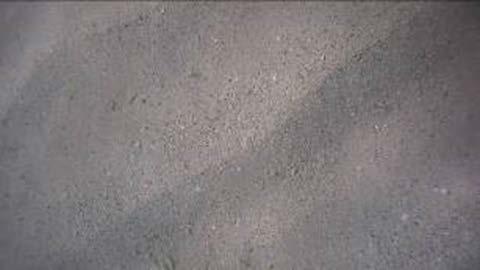
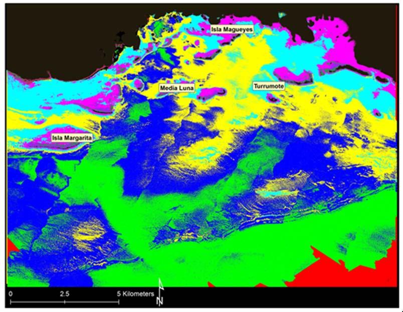
9 AVIRIS Bottom Albedo Image
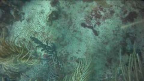
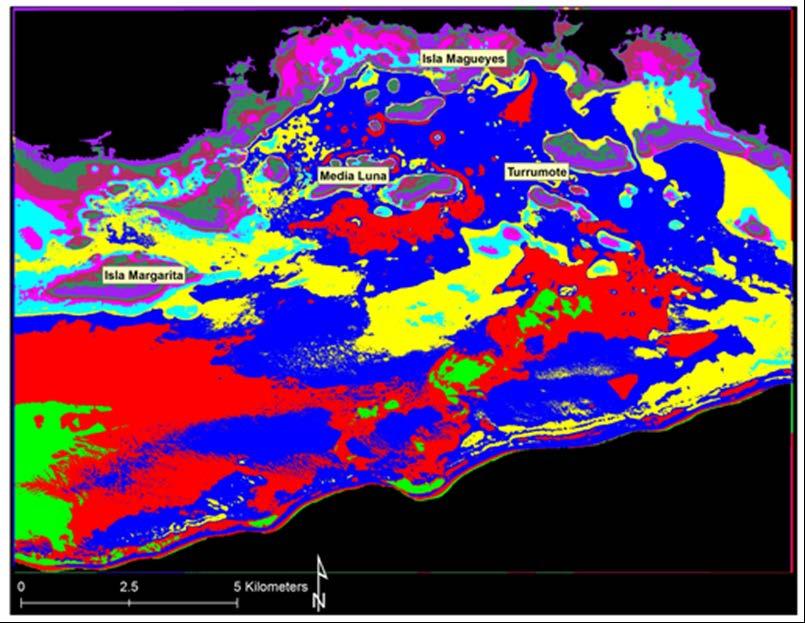
10 WV2 Bottom Albedo Image
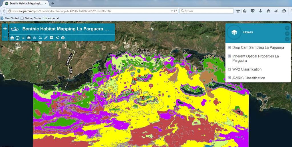
11 Benthic Habitat Mapping Goals Develop a high-resolution benthic habitat map AVIRIS and WV2 modeled bottom albedo Identify ecologically important habitats in La Parguera for scientific and management purposes. Improve the methods for developing objectivebased classifications from high-resolution satellite imagery.
12 Methods AVIRIS / WV2 Image -Atmospheric correction -Water column correction AVIRIS bottom albedo WV2 bottom albedo ISOData Raster to polygons (clusters) Field data Ground validation Accuracy assessment Legend Processing Data/Imagery Ground Validation (Spatial Join) Draft Benthic Habitat Maps Accuracy Assesment -Overall accuracy -Kappa coefficient -Tau coefficient Benthic Habitat Maps -AVIRIS -WV2


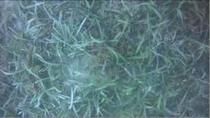

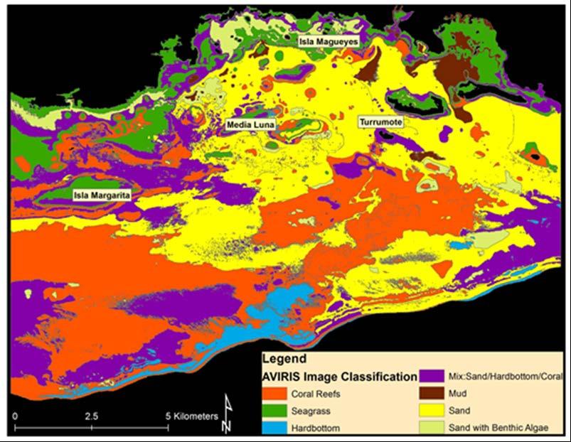
13 Benthic habitat classification scheme (1) Coral Reefs (2) Seagrass (3) Hardbottom (4) Mix: Sand/ (5) Mud (6) Sand Hardbottom/Coral (7) Sand with Benthic Algae


14 Sampling Sites Delta Vision Pro Drop Camera HD Video (1080p) 10-second video collected DVR Trimble Juno GPS 10-second averaging dgps 2 meters Synchronized GPS and video

15 Ground Validation and Accuracy Assessment Points
16 Classification Clusters obtained from ISODATA classification 150 clusters with 5 iterations Identified multiple class / benthic habitat (confused pixels) Converted to polygons in ESRI ArcMap Spatial Join Tool Polygons assigned to a class based on ground validation. Joining based on spatial location. Attribute of the nearest point is collected and a distance value is recorded. Dissolve Tool from ESRI ArcMap 10.3.
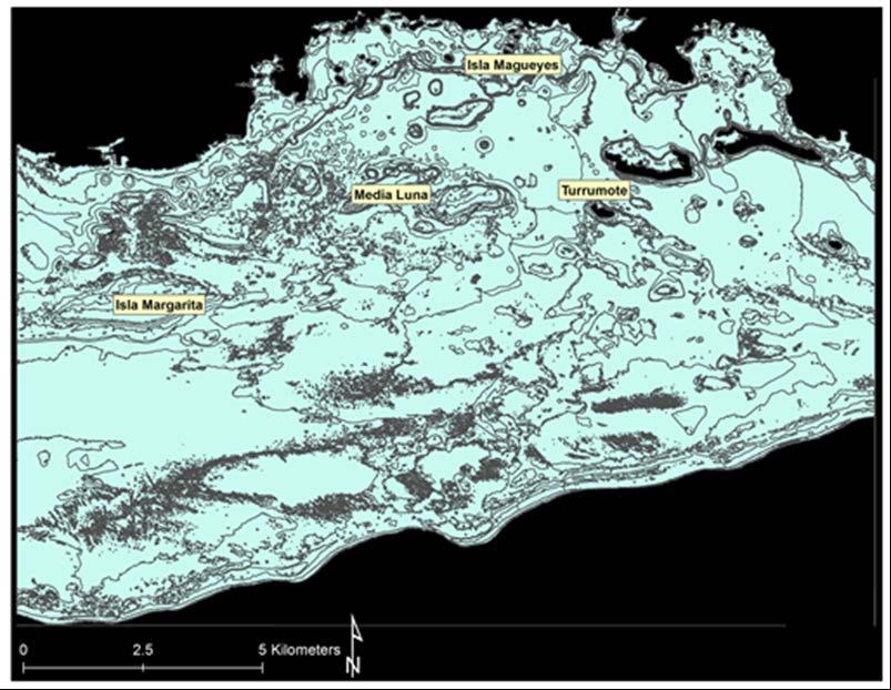
17 AVIRIS Classification (after water column correction) (before (polygon water clusters) column correction)
18 Findings Confusion matrix (Jensen, 1996) Overall Accuracy AVIRIS classification = 63.55% WV2 classification = 64.81%. Our study area ~168 Km 2 depth range from 0-41 meters (average depth = ~18 meters). Kappa coefficient AVIRIS (55%) and WV2 (57%). Moderate classification (Landis and Koch 1977) Tau coefficient AVIRIS (59%) and WV2 (60%).
19 Findings Image acquisition dates. Massive bleaching event occurred during the AVIRIS image acquisition followed by a coral reef mass-mortality (Eakin et al. 2010). Detrimental to Montastraea (Orbicella) annularis complex resulting in mortalities in the order of 50% (Garcia-Sais et al. 2008). These factors may explain the difference in the total area covered of the coral reef class between the AVIRIS image (50.32 km 2 ) and the WV2 (22.89 Km 2 ).
20 Conclusions and Remarks From top-of-atmosphere (TOA) to bottom albedo. Atmospheric and water column corrections improve benthic habitat mapping. Benthic habitat maps developed from bottom albedo images of both AVIRIS and WV2 sensors. Change detection Reduction in the coral reefs class total Development of benthic habitat mapping tools for La Parguera Reserve.

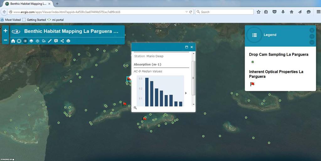
21 Web Mapping Application
22 Acknowledgements NOAA Cooperative Remote Sensing Science and Technology Center (CREST) program under grant number NA11SEC Bio-Optical Oceanography Lab team (UPRM) Dr. Liane Guild (NASA) for AVIRIS imagery Digital Globe for the WV2 imagery. QUESTIONS?
23 BACK UP SLIDES
24
25
26
High-resolution bottom albedo images and benthic habitat classification to develop baseline management tools in Natural Reserves
 High-resolution bottom albedo images and benthic habitat classification to develop baseline management tools in Natural Reserves *William J. Hernandez, Ph.D. and Roy A. Armstrong, Ph.D. *Post-Doctoral
GEOGRAPHIC INFORMATION SYSTEMS (GIS) AT GERS LAB
 AT GERS LAB") GEOGRAPHIC INFORMATION SYSTEMS (GIS) AT GERS LAB Fernando Gilbes Santaella GERS Lab-Department of Geology University of Puerto Rico at Mayaguez fernando.gilbes@upr.edu Geological and Environmental Remote
GEOGRAPHIC INFORMATION SYSTEMS (GIS) AT GERS LAB Fernando Gilbes Santaella GERS Lab-Department of Geology University of Puerto Rico at Mayaguez fernando.gilbes@upr.edu Geological and Environmental Remote
GERSVIEW: A New Database for Web Mapping
 GERSVIEW: A New Database for Web Mapping William J. Hernández, M.S. Graduate Student Department of Marine Sciences-UPRM Fernando Gilbes, Ph.D. Associate Professor Department of Geology-UPRM Overview Introduction
SATELLITE DATA COLLECTION BY THE UPRM-TCESS SPACE INFORMATION LABORATORY
 SATELLITE DATA COLLECTION BY THE UPRM-TCESS SPACE INFORMATION LABORATORY Visita a la Estación De Satélites De UPRM En el CID 16 sep. 4:30 pm Nos reuniremos al frente del CID. CID L-BAND ANTENNA Orbview
Ecological mapping using satellite imagery: an Abu Dhabi case study Middle East Geospatial Forum 16 th February 2015
 Ecological mapping using satellite imagery: an Abu Dhabi case study Middle East Geospatial Forum 16 th February 2015 Richard Flemmings rf@proteusgeo.com About Proteus Formed in UAE 2011 We specialise in
Undergraduate Research Final Report: Estimation of suspended sediments using MODIS 250 m bands in Mayagüez Bay, Puerto Rico
 Undergraduate Research Final Report: Estimation of suspended sediments using MODIS 250 m bands in Mayagüez Bay, Puerto Rico Abstract: José F. Martínez Colón Undergraduate Research 2007 802-03-4097 Advisor:
Using IKONOS Images to Evaluate Coral Reefs in Low versus High Sedimentation Environments
 Using IKONOS Images to Evaluate Coral Reefs in Low versus High Sedimentation Environments David N. Cuevas Miranda Department of Marine Sciences, University of Puerto Rico at Mayagüez P.O. Box 908 Lajas,
Weekly summary of Tropic101x as posted by student Lucia_Agudelo
 Weekly summary of Tropic101x as posted by student Lucia_Agudelo With minor grammatical and content edits by Tropic101x team Summary of Week 6 FIELD METHODS LECTURE 6.1.1 Being able to measure the distribution,
Remote Sensing of Episodic Rainfall Events Affecting Coral Reefs in Southwestern Puerto Rico
 Remote Sensing of Episodic Rainfall Events Affecting Coral Reefs in Southwestern Puerto Rico Y. Detrés, R. Armstrong, E. Otero and R. García yasmin@cacique.uprm.edu University of Puerto Rico, Mayaguez
Cross walking to the New Coastal and Marine Ecological Classification Standard (CMECS)
") Cross walking to the New Coastal and Marine Ecological Classification Standard (CMECS) Mark Finkbeiner and Chris Robinson NOAA Coastal Services Center EBM Tools Webinar 16 May 2013 Outline What is CMECS
Cross walking to the New Coastal and Marine Ecological Classification Standard (CMECS) Mark Finkbeiner and Chris Robinson NOAA Coastal Services Center EBM Tools Webinar 16 May 2013 Outline What is CMECS
Outline Introduction Objectives Study Area Methodology Result Discussion Conclusion
 Land Cover, Land Use of two bioluminescent bays in Puerto Rico Undergraduate Research By: Yadira Soto Viruet Advisor: Fernando Gilbes Santaella, Ph.D Outline Introduction Objectives Study Area Methodology
Using Remote Sensing to Map the Evolution of Marsh Vegetation in the South Bay of San Francisco
 Using Remote Sensing to Map the Evolution of Marsh Vegetation in the South Bay of San Francisco Brian Fulfrost Design, Community and Environment (DC&E) 6 th Annual Bay-Delta Science Conference PROJECT
GIS and Remote Sensing
 Spring School Land use and the vulnerability of socio-ecosystems to climate change: remote sensing and modelling techniques GIS and Remote Sensing Katerina Tzavella Project Researcher PhD candidate Technology
F. Muller-Karger, M. Eakin, L. Guild, C. Hu, M. Vega, R. Nemani, T. Christensen, L. Wood, C. Ravillious, C. Nim, J. Li, C. Fitzgerald, J. Hendee, L.
 F. Muller-Karger, M. Eakin, L. Guild, C. Hu, M. Vega, R. Nemani, T. Christensen, L. Wood, C. Ravillious, C. Nim, J. Li, C. Fitzgerald, J. Hendee, L. Gramer, S. Lynds Partnerships NOAA NESDIS/CRW-CRCP (Mark
SATELLITE REMOTE SENSING
 SATELLITE REMOTE SENSING of NATURAL RESOURCES David L. Verbyla LEWIS PUBLISHERS Boca Raton New York London Tokyo Contents CHAPTER 1. SATELLITE IMAGES 1 Raster Image Data 2 Remote Sensing Detectors 2 Analog
Storm Surge on a Coral Atoll: The Case of Fongafale Islet in Tuvalu. Lawrence Burkett UND 8 April 2016
 Storm Surge on a Coral Atoll: The Case of Fongafale Islet in Tuvalu Lawrence Burkett UND 8 April 2016 Photograph courtesy of Seelan 2015 using an iphone6 Fongafale Ship Built Structure Anvil Cirrus Cumulus
REFERENCE: The Blue Planet An Introduction to Earth System Science. Brian J. Skinner and Barbara W. Murck (2011) Third Edition. John Wiley and Sons
 Third Edition. John Wiley and Sons") REFERENCE: The Blue Planet An Introduction to Earth System Science. Brian J. Skinner and Barbara W. Murck (2011) Third Edition. John Wiley and Sons Inc. Most life on Earth lives within a zone no wider
REFERENCE: The Blue Planet An Introduction to Earth System Science. Brian J. Skinner and Barbara W. Murck (2011) Third Edition. John Wiley and Sons Inc. Most life on Earth lives within a zone no wider
Remote detection of giant reed invasions in riparian habitats: challenges and opportunities for management planning
 Remote detection of giant reed invasions in riparian habitats: challenges and opportunities for management planning Maria do Rosário Pereira Fernandes Forest Research Centre, University of Lisbon Number
The 2010 Fiji coral reef system map is given in an ArcMap shapefile format and consists of seven associated files:
 METADATA The 2010 Fiji coral reef system map is given in an ArcMap shapefile format and consists of seven associated files: 1. fj20100815qbikon_kadavu_habitat_map.shp 2. fj20100815qbikon_kadavu_habitat_map.dbf
Satellite Oceanography and Applications 1: Introduction, SST, Ocean color
 Satellite Oceanography and Applications 1: Introduction, SST, Ocean color Ebenezer Nyadjro US Naval Research Lab RMU Summer Program (AUGUST 24-28, 2015) Objectives/Goals To know the basic methods of ocean
Spatial Accuracy Assessment for Coral Reef Classifications. Supawan Wongprayoon 1 Carlos Antonio Oliveira Vieira 2 Joseph Henry John Leach 3
 Spatial Accuracy Assessment for Coral Reef Classifications Supawan Wongprayoon 1 Carlos Antonio Oliveira Vieira 2 Joseph Henry John Leach 3 1, 3 Department of Geomatics, The University of Melbourne, Parkville,
Joint Hydrographic Center, National Oceanic and Atmospheric Administration, Durham, NH 03824, USA
 Future directions in hydrography using satellite-derived bathymetry Shachak Pe eri 1, Christopher Parrish 2, 3, Lee Alexander 1, Chukwuma Azuike 1, Andrew Armstrong 1,3 and Maryellen Sault 2 1 Center for
Final Report. Accuracy Assessment and Monitoring for NOAA Florida Keys mapping ROI 2 (Key West) February 10, 2010
 February 10, 2010") Final Report Accuracy Assessment and Monitoring for NOAA Florida Keys mapping ROI 2 (Key West) February 10, 2010 Submitted by: Brian K. Walker, Ph.D. & Greg Foster, M.S. National Coral Reef Institute Nova
Final Report Accuracy Assessment and Monitoring for NOAA Florida Keys mapping ROI 2 (Key West) February 10, 2010 Submitted by: Brian K. Walker, Ph.D. & Greg Foster, M.S. National Coral Reef Institute Nova
Lesson 4b Remote Sensing and geospatial analysis to integrate observations over larger scales
 Lesson 4b Remote Sensing and geospatial analysis to integrate observations over larger scales We have discussed static sensors, human-based (participatory) sensing, and mobile sensing Remote sensing: Satellite
Spatial Process VS. Non-spatial Process. Landscape Process
 Spatial Process VS. Non-spatial Process A process is non-spatial if it is NOT a function of spatial pattern = A process is spatial if it is a function of spatial pattern Landscape Process If there is no
Projects in the Remote Sensing of Aerosols with focus on Air Quality
 Projects in the Remote Sensing of Aerosols with focus on Air Quality Faculty Leads Barry Gross (Satellite Remote Sensing), Fred Moshary (Lidar) Direct Supervision Post-Doc Yonghua Wu (Lidar) PhD Student
10/13/2011. Introduction. Introduction to GPS and GIS Workshop. Schedule. What We Will Cover
 Introduction Introduction to GPS and GIS Workshop Institute for Social and Environmental Research Nepal October 13 October 15, 2011 Alex Zvoleff azvoleff@mail.sdsu.edu http://rohan.sdsu.edu/~zvoleff Instructor:
Determining inherent optical properties, bathymetry and benthic types using HICO imagery within northeast and western Australia
 1 Determining inherent optical properties, bathymetry and benthic types using HICO imagery within northeast and western Australia Abstract Within Australia, information regarding light attenuation, bathymetry
Application of Remote Sensing and GIS in Wildlife Habitat Mapping
 Justice Camillus Mensah December 6, 2011 NRS 509 Application of Remote Sensing and GIS in Wildlife Habitat Mapping Introduction Wildlife habitat represents the physical space within which an organism lives.
Confidence Assessment Scoring System
 Confidence Assessment Scoring System Confidence field Confidence group Confidence question Comments Remote sensing data collection RemoteTechnique Were the techniques used appropriate for the ground type?
Remote Sensing ISSN
 Remote Sens. 2011, 3, 42-64; doi:10.3390/rs3010042 Article OPEN ACCESS Remote Sensing ISSN 2072-4292 www.mdpi.com/journal/remotesensing Integrating Quickbird Multi-Spectral Satellite and Field Data: Mapping
Studying coral reef ecosystems with NASA tools in an age of climate change and coral bleaching: the role of spectroscopy
 Studying coral reef ecosystems with NASA tools in an age of climate change and coral bleaching: the role of spectroscopy Juan L. Torres-Pérez, PhD, Liane S. Guild and Roy Armstrong Bay Area Environmental
An Exploration of the Potential for Opti-Acoustic Seabed Classification
 An Exploration of the Potential for Opti-Acoustic Seabed Classification R. Pamela Reid Marine Geology and Geophysics Rosenstiel School of Marine and Atmospheric Science University of Miami 4600 Rickenbacker
Edwin A. Hernández-Delgado*
 Long-term Coral Reef Ecological Change Monitoring Program of the Luis Peña Channel Marine Fishery Reserve, Culebra Island, Puerto Rico: I. Status of the coral reef epibenthic communities (1997-2002). Edwin
Introduction: The Gulf of Mexico Alliance. The Gulf GAME project MERMAid and PHINS Results & Conclusions What s next? Examples
 AAG Las Vegas March 25, 2009 Introduction: Ocean governance and Ecosystem-Based Management The Gulf of Mexico Alliance Habitat Identification and Characterization The Gulf GAME project MERMAid and PHINS
Overview of Remote Sensing in Natural Resources Mapping
 Overview of Remote Sensing in Natural Resources Mapping What is remote sensing? Why remote sensing? Examples of remote sensing in natural resources mapping Class goals What is Remote Sensing A remote sensing
PRINCIPLE OF OCEANOGRAPHY PBBT101 UNIT-1 INTRODUCTION OF OCEANIC ENVIRONMENT. PART-A (2 Marks)
") PRINCIPLE OF OCEANOGRAPHY PBBT101 UNIT-1 INTRODUCTION OF OCEANIC ENVIRONMENT 1. Define marine ecosystem. 2. What is geography? 3. Give two Oceanic zones 4. What is sea? 5. Define oceanography? 6. Enlist
PRINCIPLE OF OCEANOGRAPHY PBBT101 UNIT-1 INTRODUCTION OF OCEANIC ENVIRONMENT 1. Define marine ecosystem. 2. What is geography? 3. Give two Oceanic zones 4. What is sea? 5. Define oceanography? 6. Enlist
Impacts of Atmospheric Corrections on Algal Bloom Detection Techniques
 1 Impacts of Atmospheric Corrections on Algal Bloom Detection Techniques Ruhul Amin, Alex Gilerson, Jing Zhou, Barry Gross, Fred Moshary and Sam Ahmed Optical Remote Sensing Laboratory, the City College
Satellite Remote Sensing for Ocean
 Satellite Remote Sensing for Ocean August 17, 2017 Masatoshi Kamei RESTEC All rights reserved RESTEC 2015 Contents 1. About RESTEC and Remote Sensing 2. Example of Remote Sensing Technology 3. Remote Sensing
Developing Soil Maps and Interpretations for Shallow Subtidal Habitats
 Developing Soil Maps and Interpretations for Shallow Subtidal Habitats James D. Turenne Assistant State Soil Scientist Rhode Island (The Ocean State) USDA-NRCS Narragansett Bay Estuary LNB Coastal Lagoons
Bayesian Methodology for Atmospheric Correction of PACE Ocean-Color Imagery
 Bayesian Methodology for Atmospheric Correction of PACE Ocean-Color Imagery Robert Frouin, PI Scripps Institution of Oceanography, University of California San Diego, La Jolla, USA Bruno Pelletier, Co-I
Coastal Zone Mapping and Imaging Lidar (CZMIL)
") Coastal Zone Mapping (CZMIL) Shallow Survey 2012 Wellington, New Zealand Christopher L. Macon U.S. Army Corps of Engineers, Mobile District Joint Airborne Lidar Bathymetry Technical Center of expertise
Coastal Zone Mapping (CZMIL) Shallow Survey 2012 Wellington, New Zealand Christopher L. Macon U.S. Army Corps of Engineers, Mobile District Joint Airborne Lidar Bathymetry Technical Center of expertise
Application of remote sensing methods to assess the spatial extent of the seagrass resource in St. Joseph Sound and Clearwater Harbor, Florida, U.S.A.
 University of South Florida Scholar Commons Graduate Theses and Dissertations Graduate School 2008 Application of remote sensing methods to assess the spatial extent of the seagrass resource in St. Joseph
GIS and Forest Engineering Applications FE 357 Lecture: 2 hours Lab: 2 hours 3 credits
 GIS and Forest Engineering Applications FE 357 Lecture: 2 hours Lab: 2 hours 3 credits Instructor: Michael Wing Assistant Professor Forest Engineering Department Oregon State University Peavy Hall 275
Display data in a map-like format so that geographic patterns and interrelationships are visible
 Vilmaliz Rodríguez Guzmán M.S. Student, Department of Geology University of Puerto Rico at Mayagüez Remote Sensing and Geographic Information Systems (GIS) Reference: James B. Campbell. Introduction to
Application of Remote Sensing and Global Positioning Technology for Survey and Monitoring of Plant Pests
 Application of Remote Sensing and Global Positioning Technology for Survey and Monitoring of Plant Pests David Bartels, Ph.D. USDA APHIS PPQ CPHST Mission Texas Laboratory Spatial Technology and Plant
Carte des peuplements benthiques des substrats meubles de la baie de Saint-Brieuc (Source Thouzeau G., Hamon D., 1992) - Echelle 1/ Score sheet
 - Echelle 1/ Score sheet") 16/07/2010 Carte des peuplements benthiques des substrats meubles de la baie de Saint-Brieuc (Source Thouzeau G., Hamon D., 1992) - Echelle 1/100000 sheet sensing? How good is the ground-truthing? How
16/07/2010 Carte des peuplements benthiques des substrats meubles de la baie de Saint-Brieuc (Source Thouzeau G., Hamon D., 1992) - Echelle 1/100000 sheet sensing? How good is the ground-truthing? How
NOAA s OCM: Services, tools and collaboration opportunities & Puerto Rico s NE Marine Corridor as a case study
 NOAA s OCM: Services, tools and collaboration opportunities & Puerto Rico s NE Marine Corridor as a case study Dr. Antares Ramos Álvarez NOAA s Office of Coastal Management September 15 th, 2016 Conservation
Jay Dimond NRS /30/04
 Mapping and Prediction of Coral Bleaching Using GIS Corals on coral reefs bleach when they lose their complement of intracellular symbiotic algae known as zooxanthellae. Coral color varies widely, but
These modules are covered with a brief information and practical in ArcGIS Software and open source software also like QGIS, ILWIS.
 Online GIS Training and training modules covered are: 1. ArcGIS, Analysis, Fundamentals and Implementation 2. ArcGIS Web Data Sharing 3. ArcGIS for Desktop 4. ArcGIS for Server These modules are covered
NOAA Great Lakes CoastWatch Program
 Great Lakes Workshop Series on Remote Sensing of Water Quality May 7-8, 2014 NOAA GLERL, 4840 South State Rd, Ann Arbor, MI NOAA Great Lakes CoastWatch Program CoastWatch is a nationwide National Oceanic
Analysis of the particle size distribution and optical properties in the Korean seas
 Analysis of the particle size distribution and optical properties in the Korean seas Boram Lee 1,2, Young-Je Park 1, Wonkook Kim 1, Jae-Hyun Ahn 1, Kwangseok Kim 1, Jeong-Eon Moon 1 and Sang-Wan Kim 2
Modeling Coastal Change Using GIS Technology
 Emily Scott NRS 509 Final Report December 5, 2013 Modeling Coastal Change Using GIS Technology In the past few decades, coastal communities around the world are being threatened by accelerating rates of
Coral reef destruction of Small island in 44 years and destructive fishing in Spermonde Archipelago, Indonesia
 IOP Conference Series: Earth and Environmental Science PAPER OPEN ACCESS Coral reef destruction of Small island in 44 years and destructive fishing in Spermonde Archipelago, Indonesia To cite this article:
Current and Future Technology Applications for Coastal Zone Management. Bruce K. Carlisle, Acting Director Office of Coastal Zone Management
 Current and Future Technology Applications for Coastal Zone Management Bruce K. Carlisle, Acting Director Office of Coastal Zone Management The Massachusetts Coastal Zone Management Program Approved in
Bottom albedo derivations using hyperspectral spectrometry and multispectral video
 University of South Florida Scholar Commons Graduate Theses and Dissertations Graduate School 2005 Bottom albedo derivations using hyperspectral spectrometry and multispectral video Andrew Scott Farmer
Welcome to NR502 GIS Applications in Natural Resources. You can take this course for 1 or 2 credits. There is also an option for 3 credits.
 Welcome to NR502 GIS Applications in Natural Resources. You can take this course for 1 or 2 credits. There is also an option for 3 credits. The 1st credit consists of a series of readings, demonstration,
Polarization measurements in coastal waters using a hyperspectral multiangular sensor
 Polarization measurements in coastal waters using a hyperspectral multiangular sensor A. Tonizzo 1, J. Zhou 1, A. Gilerson 1, T. Iijima 1, M. Twardowski 2, D. Gray 3, R. Arnone 3, B. Gross 1, F. Moshary
Data Aggregation with InfraWorks and ArcGIS for Visualization, Analysis, and Planning
 Data Aggregation with InfraWorks and ArcGIS for Visualization, Analysis, and Planning Stephen Brockwell President, Brockwell IT Consulting, Inc. Join the conversation #AU2017 KEYWORD Class Summary Silos
Minutes of the First Meeting. of the IOCCG Working Group. L1 Requirements for Ocean-Colour Remote Sensing. April 20-21, 2010
 Minutes of the First Meeting of the IOCCG Working Group L1 Requirements for Ocean-Colour Remote Sensing April 20-21, 2010 Bethesda, Maryland (Washington, D.C.), USA Participants: - Charles R. McClain (chair,
Assessing the Thematic Accuracy for Coral Reef Classification
 Assessing the Thematic Accuracy for Coral Reef Classification Supawan Wongprayoon 1, Carlos A.O. Vieira 2, and Joseph J. H. Leach 1 1 Department of Geomatics, The University of Melbourne, Parkville, VIC
Satellite derived bathymetry and seafloor mapping of the coastal zone
 Satellite derived bathymetry and seafloor mapping of the coastal zone 2016-11-09 EOMAP GmbH & Co.KG Germany Australia USA www.eomap.com info@eomap.de About EOMAP Filling data gaps o Founded in 2006 with
EBS 566/666 Lecture 8: (i) Energy flow, (ii) food webs
 Energy flow, (ii) food webs") EBS 566/666 Lecture 8: (i) Energy flow, (ii) food webs Topics Light in the aquatic environment Energy transfer and food webs Algal bloom as seen from space (NASA) Feb 1, 2010 - EBS566/666 1 Requirements
EBS 566/666 Lecture 8: (i) Energy flow, (ii) food webs Topics Light in the aquatic environment Energy transfer and food webs Algal bloom as seen from space (NASA) Feb 1, 2010 - EBS566/666 1 Requirements
CHANGE DETECTION FROM LANDSAT-5 TM SATELLITE DATA
 CHANGE DETECTION FROM LANDSAT-5 TM SATELLITE DATA Ummi Kalsom Mohd Hashim 1, Asmala Ahmad 1, Burhanuddin Mohd. Aboobaider 1, Hamzah Sakidin 2, Subatira B. 3 and Mohd Saari Mohamad Isa 4 1 Faculty of Information
Coastal and Marine Ecological Classification Standard (CMECS)
") Coastal and Marine Ecological Classification Standard (CMECS) Mark Finkbeiner NOAA Coastal Services Center Presented at the International Workshop on Seabed Mapping Methods and Technology 18 October 2012
Coastal and Marine Ecological Classification Standard (CMECS) Mark Finkbeiner NOAA Coastal Services Center Presented at the International Workshop on Seabed Mapping Methods and Technology 18 October 2012
USING HYPERSPECTRAL IMAGERY
 USING HYPERSPECTRAL IMAGERY AND LIDAR DATA TO DETECT PLANT INVASIONS 2016 ESRI CANADA SCHOLARSHIP APPLICATION CURTIS CHANCE M.SC. CANDIDATE FACULTY OF FORESTRY UNIVERSITY OF BRITISH COLUMBIA CURTIS.CHANCE@ALUMNI.UBC.CA
An evaluation of two semi-analytical ocean color algorithms for waters of the South China Sea
 28 5 2009 9 JOURNAL OF TROPICAL OCEANOGRAPHY Vol.28 No.5 Sep. 2009 * 1 1 1 1 2 (1. ( ), 361005; 2. Northern Gulf Institute, Mississippi State University, MS 39529) : 42, QAA (Quasi- Analytical Algorithm)
Research in Airborne Remote Sensing: Heat Flux in Giant Kelp Forests on the Santa Barbara Coast Runyon Colie Woods
 Research in Airborne Remote Sensing: Heat Flux in Giant Kelp Forests on the Santa Barbara Coast Runyon Colie Woods Advisors: Dr. Dylan McNamara Dr. Raphael Kudela (UCSC) SARP and the DC-8 Remote Sensing
HYPERSPECTRAL IMAGING
 1 HYPERSPECTRAL IMAGING Lecture 9 Multispectral Vs. Hyperspectral 2 The term hyperspectral usually refers to an instrument whose spectral bands are constrained to the region of solar illumination, i.e.,
RESEARCH EDGE SPECTRAL REMOTE SENSING OF THE COAST. Karl Heinz Szekielda
 Research Edge Working Paper Series, no. 8 p. 1 RESEARCH EDGE SPECTRAL REMOTE SENSING OF THE COAST Karl Heinz Szekielda City University of New York Fulbright Scholar at, Nassau, The Bahamas Email: karl.szekielda@gmail.com
The Application of CHRIS Data to the Multi-temporal & Multi-angular Study of Near-shore Marine Bathymetry
 The Application of CHRIS Data to the Multi-temporal & Multi-angular Study of Near-shore Marine Bathymetry PhD/Postgrad students: Libby Boak Stacy Mitchell AJ Lau Indrie Miller School of Biological, Earth,
Benthic Habitats of Gray s Reef National Marine Sanctuary
 Benthic Habitats of Gray s Reef National Marine Sanctuary NOAA National Ocean Service National Centers for Coastal Ocean Science Center for Coastal Monitoring and Assessment Biogeography Team Kendall,
JALBTCX AND THE USACE NATIONAL COASTAL MAPPING PROGRAM
 JALBTCX AND THE USACE NATIONAL COASTAL MAPPING PROGRAM 237 237 237 217 217 217 200 200 200 80 119 27 252 174.59 1 255 255 255 0 0 0 163 163 163 131 132 122 239 65 53 110 135 120 112 92 56 62 102 130 102
Multiple methods, maps, and management applications: purpose made maps in support of Ocean Management. Craig J. Brown McGregor GeoScience Ltd.
 Multiple methods, maps, and management applications: purpose made maps in support of Ocean Management Craig J. Brown McGregor GeoScience Ltd. International workshop on seabed mapping methods and technology,
Work Package 5: Signal Processing and Seafloor Classification
 Work Package 5: Signal Processing and Seafloor Classification Jarosław Tęgowski and Karolina Trzcińska Marine Geophysics Lab. Institute of Oceanography University of Gdańsk, Poland Kick-Off Meeting, Kiel,
Calibration and Validation for Ocean Color Remote Sensing 10 July 4 August, 2017 Darling Marine Center, University of Maine, Walpole ME
 Calibration and Validation for Ocean Color Remote Sensing 10 July 4 August, 2017 Darling Marine Center, University of Maine, Walpole ME Meals: breakfast 0730; lunch 1200; dinner 1800; weekends will be
Applications of GIS and Remote Sensing involving Marine Debris
 Sara Benson NRS 509 December 8, 2016 Applications of GIS and Remote Sensing involving Marine Debris Plastics are a significant component of our anthropogenic impact on the environment, especially in our
NR402 GIS Applications in Natural Resources. Lesson 9: Scale and Accuracy
 NR402 GIS Applications in Natural Resources Lesson 9: Scale and Accuracy 1 Map scale Map scale specifies the amount of reduction between the real world and the map The map scale specifies how much the
Conservative bias in classification accuracy assessment due to pixelby-pixel comparison of classified images with reference grids
 INT. J. REMOTE SENSING, 1995, VOL. 16, No.3, 581-587 Conservative bias in classification accuracy assessment due to pixelby-pixel comparison of classified images with reference grids D. L. VERBYLA and
MULTI-SOURCE IMAGE CLASSIFICATION
 MULTI-SOURCE IMAGE CLASSIFICATION Hillary Tribby, James Kroll, Daniel Unger, I-Kuai Hung, Hans Williams Corresponding Author: Daniel Unger (unger@sfasu.edu Arthur Temple College of Forestry and Agriculture
Marine Ecology Pacing Guide
 Marine Ecology Pacing Guide Course Description: The focus of the course is the interrelationships among marine organisms and the physical, chemical, geological and biological factors. North Carolina coastal
University of Puerto Rico Mayagüez Campus Department of Geology
 University of Puerto Rico Mayagüez Campus Department of Geology Undergraduate Research Final Report: Development of a site-specific algorithm to estimate suspended sediments using MODIS José F. Martínez
McIDAS support of Suomi-NPP /JPSS and GOES-R L2
 McIDAS support of Suomi-NPP /JPSS and GOES-R L2 William Straka III 1 Tommy Jasmin 1, Bob Carp 1 1 Cooperative Institute for Meteorological Satellite Studies, Space Science and Engineering Center, University
Optical Detection and Assessment of the Harmful Alga, Karenia brevis
 Optical Detection and Assessment of the Harmful Alga, Karenia brevis Steven E. Lohrenz Department of Marine Science The University of Southern Mississippi 1020 Balch Boulevard Stennis Space Center, MS
Sediment classification from multibeam backscatter images using simple histogram analysis
 Sediment classification from multibeam backscatter images using simple histogram analysis Rozaimi Che Hasan 1,2, Mohd Razali Mahmud 3 and Shahrin Amizul Shamsudin 1 1 UTM Razak School of Engineering and
Liana Talaue McManus. Division of Marine Affairs and Policy Rosenstiel School of Marine & Atmospheric Science University of Miami
 Liana Talaue McManus Division of Marine Affairs and Policy Rosenstiel School of Marine & Atmospheric Science University of Miami Outline 1. Coasts as vulnerable & resilient social ecological systems 2.
Shallow-Water Benthic Habitats of St. John, U.S. Virgin Islands
 Shallow-Water Benthic Habitats of St. John, U.S. Virgin Islands NATIONAL OCEANIC AND ATMOSPHERIC ADMINISTRATION Adam G. Zitello Laurie J. Bauer Timothy A. Battista Peter W. Mueller Matthew S. Kendall Mark
Seasonal variability in the vertical attenuation coefficient at 490 nm (K490) in waters around Puerto Rico and US Virgin Islands.
 in waters around Puerto Rico and US Virgin Islands.") Seasonal variability in the vertical attenuation coefficient at 490 nm (K490) in waters around Puerto Rico and US Virgin Islands. William J. Hernandez 1 and Fernando Gilbes 2 1 Department of Marine Science,
Seasonal variability in the vertical attenuation coefficient at 490 nm (K490) in waters around Puerto Rico and US Virgin Islands. William J. Hernandez 1 and Fernando Gilbes 2 1 Department of Marine Science,
Atmospheric Correction of Ocean Color RS Observations
 Atmospheric Correction of Ocean Color RS Observations Menghua Wang NOAA/NESDIS/STAR E/RA3, Room 3228, 5830 University Research Ct. College Park, MD 20740, USA IOCCG Summer Lecture Series, Villefranche-sur-Mer,
Dr.N.Chandrasekar Professor and Head Centre for GeoTechnology Manonmaniam Sundaranar University Tirunelveli
 Classification and Segmentation of Coastal Landforms in the South Tamilnadu Coast Dr.N.Chandrasekar Professor and Head Centre for GeoTechnology Manonmaniam Sundaranar University Tirunelveli E-mail: profncsekar@gmail.com
Imagery and the Location-enabled Platform in State and Local Government
 Imagery and the Location-enabled Platform in State and Local Government Fred Limp, Director, CAST Jim Farley, Vice President, Leica Geosystems Oracle Spatial Users Group Denver, March 10, 2005 TM TM Discussion
GIS Workshop Data Collection Techniques
 GIS Workshop Data Collection Techniques NOFNEC Conference 2016 Presented by: Matawa First Nations Management Jennifer Duncan and Charlene Wagenaar, Geomatics Technicians, Four Rivers Department QA #: FRG
Geographical Information Systems
 Geographical Information Systems Geographical Information Systems (GIS) is a relatively new technology that is now prominent in the ecological sciences. This tool allows users to map geographic features
Mapping Willow Distribution Across the Northern Range of Yellowstone National Park
 Mapping Willow Distribution Across the Northern Range of Yellowstone National Park 2004 Final Report Jeremy P. Shive and Robert L. Crabtree Yellowstone Ecological Research Center April 1, 2004 Table of
CLASSIFICATION OF SEAGRASS HABITAT STRUCTURE AS A RESPONSE TO WAVE EXPOSURE AT ETOILE CAY, SEYCHELLES
 EARSeL eproceedings 6, 2/2007 94 CLASSIFICATION OF SEAGRASS HABITAT STRUCTURE AS A RESPONSE TO WAVE EXPOSURE AT ETOILE CAY, SEYCHELLES Sarah Hamylton and Tom Spencer Cambridge Coastal Research Unit, Department
Monitoring Coastal Marshes for Persistent Saltwater Intrusion
 Monitoring Coastal Marshes for Persistent Saltwater Intrusion Maria Kalcic, 1 Callie Hall, 2 Jeff Russell, 3 and Rose Fletcher 1 1 Science Systems and Applications, Inc., Bldg. 1105, John C. Stennis Space
Estimation of ocean contribution at the MODIS near-infrared wavelengths along the east coast of the U.S.: Two case studies
 GEOPHYSICAL RESEARCH LETTERS, VOL. 32, L13606, doi:10.1029/2005gl022917, 2005 Estimation of ocean contribution at the MODIS near-infrared wavelengths along the east coast of the U.S.: Two case studies
Physical-Biological-Optics Model Development and Simulation for the Pacific Ocean and Monterey Bay, California
 DISTRIBUTION STATEMENT A: Approved for public release; distribution is unlimited. Physical-Biological-Optics Model Development and Simulation for the Pacific Ocean and Monterey Bay, California Fei Chai
Time Series Analysis with SAR & Optical Satellite Data
 Time Series Analysis with SAR & Optical Satellite Data Thomas Bahr ESRI European User Conference Thursday October 2015 harris.com Motivation Changes in land surface characteristics mirror a multitude of
GIS and Forest Engineering Applications FE 257 Lecture and laboratory, 3 credits
 GIS and Forest Engineering Applications FE 257 Lecture and laboratory, 3 credits Instructor: Michael Wing Associate Professor Forest Engineering, Resources, and Management Oregon State University Crop