CARIWIN Regional Seminar January 14-15, 2010, Georgetown, Guyana
|
|
|
- Charity Hood
- 5 years ago
- Views:
Transcription
1 Creating the North American Drought Monitor Angel (Bennett) McCoy NOAA/Climate Prediction Center Camp Springs, Maryland, U.S.A. Doug LeComte NOAA/Climate Prediction Center Richard R. Heim Jr. NOAA/National Climatic Data Center Trevor Hadwen Agriculture and Agri-Food Canada CARIWIN Regional Seminar January 14-15, 2010, Georgetown, Guyana
2 Overview NADM Participants & Responsibilities National Drought Depictions USDM NADM Procedure & Deadlines


3 NADM Participants & Responsibilities Participants i t Canada: Agriculture & Agri-Food Canada, Environment Canada U.S.: NOAA, USDA, National Drought Mitigation Center Mexico: National Meteorological Service (SMN) Responsibilities Each country determines drought depiction & narrative within their national boundaries NADM lead authorship hi rotates t amongst the participants NADM lead author integrates national drought assessments from each country, prepares continental monthly map & narrative All participants i t peer review product
 prepares the drought depiction within their own borders The three maps are merged into one map addressing any border discrepancies")
4 National Drought Depictions The NADM map is actually 3 maps merged into one. Each country (Canada, U.S., Mexico) prepares the drought depiction within their own borders The three maps are merged into one map addressing any border discrepancies through discussion and reanalyzing the data.


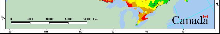
5 The U.S. Portion of NADM is based on the U.S. Drought Monitor Since the U.S. Drought Monitor is produced weekly, the NADM authors take the g p y, ArcGIS shapefiles from the weekly USDM map that best represents U.S. drought conditions at the end month.


6 U.S. Drought Monitor (USDM) A partnership between the National Drought Mitigation Center, USDA/JAWF, NOAA s CPC, NCDC, & WRCC Authors USDM is an operational product issued weekly and provides a general upto-date summary of current drought conditions across the Lower 48 States, Hawaii, Alaska, & Puerto Rico; first issued in drought categories (D1-D4) plus abnormally dry (D0) category, based on percentile rank Percentile Rank: D0 Abnormally Dry D1 Drought Moderate D2 Drought Severe D3 Drought Extreme D4 Drought Exceptional 6
7 USDM Drought Severity Classification The USDM depiction was designed to reflect the consensus of key indicators. Drought Severity Classification Table Ranges Category Description Possible Impacts Palmer Index CPC Soil Moisture Percentiles Weekly Streamflow Percentiles SPI Drought Indicator Blends Percentiles D0 Abnormally dry Slowed planting, lingering water shortages -1 to to D1 Moderate drought Some crop damage, water supplies low -2 to to D2 Severe drought Crop losses likely, water shortages common -3 to to D3 Extreme drought Major crop losses, widespread water shortages -4 to to D4 Exceptional drought Exceptional and widespread crop losses, water emergencies -5 or less or less 0-2
8 Pros and Cons of the USDM Methodology Pros Cons Incorporates numerous drought indicators ***Draft maps elicit feedback from the field. *** Authors do not necessarily follow the indicators, and each one interprets and weights them differently. Subjectivity introduced. Feedback may not follow guidelines for assigning drought intensity levels DM authors reluctant to oppose advice even when suspect. Diversification ifi of drought authors, offering 9 authors among 5 agencies results in fresh perspectives inconsistencies. Ground truth/impacts considered Each DM author has considerable flexibility when creating the DM maps. Impacts difficult to quantify No standards/rules followed on minimum size of areas, assignment of D levels, training of authors, removal of authors. No verification or audits of results. No final arbiter of results. No method of arbitrating disputes.


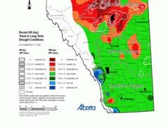
9 Assessment for Canada The Canadian drought contours are analyzed by the NAIS of AAFC. Then the shapefiles h fil are produced d d & merged d with ith the U.S. drought contours, and provided to the NADM author. The monthly Th thl assessments t are based b d on a wide range of products at national, provincial and regional scales. The data consist of near real time monitoring maps, maps from the national drought model, and a wide variety of provincial/regional products. Assessments also use conditions & reports from other agencies including provincial crop reports, stream flow p, low water level advisories. reports,


10 Canadian Analysis Other Supplemental l Indicators for Canada Data gathered through monthly producer surveys Remotely Sensed Data CPC

, NDVI imagery and")
11 Assessment for Mexico Mexico i performs internal drought assessment and provides shapefiles for the country by the 8th of each month. A number of inputs are utilized, such as station precipitation data, Palmer drought indices, SPI, reservoir information (when available), NDVI imagery and other sources of climate/hydrological data.


12 Mexican Analysis Other Supplemental l Indicators for Mexico SMN CPC CPC


13 The map drafts are distributed via and any user comments are considered for possible modifications, mainly along the international borders. However, since all 3 countries drought analyses had been previously reviewed internally, there is usually little or no feedback at this point. Draft #3


14 DRAFT#1 Text Summaries Each country writes their own summaries and sends the text t to the NADM lead author. The U.S. summary is often a condensed version of the 4 to 5 weekly U.S. Drought Monitor summaries, or from the monthly U.S. summary in NCDC s monthly drought report or JAWF s Weekly Weather and Crop Bulletin, or a combination. The combined draft text summary is disseminated via , and any user comments are considered for possible modifications. When finalized, the text summary is translated into French & Spanish then sent back to NCDC for Web inclusion. i
15 Final Product
16 NADM Procedure & Deadlines By 5 th of the Month: NCDC receives international ti (station) ti data from Mexico and Canada NADM author decides which weekly U.S. Drought Monitor depiction will be used for the U.S., sends USDM shapefiles to Canada By 7 th of the Month: NCDC produces (and puts online) continent-scale indicator maps from the Canadian, Mexican, Alaska, and contiguous U.S. data By 8 th of the Month: Mexico provides shapefiles of Mexican depiction to lead author Canada provides shapefiles of Canadian depiction to lead author Lead author merges all shapefiles to create continental shapefiles/map
17 NADM Procedure & Deadlines By 10 th of the Month: NADM lead author adjusts drought depiction along international boundaries, distributes NADM map to all participants for peer review, produces additional drafts as necessary per peer review comments By 12 th of the Month: Each country provides the narrative text to the lead author, who integrates all text & distributes the continental narrative for peer review NADM continental map depiction finalized By 14 th of the Month: Each country gives final approval of NADM map & narrative to lead author Lead author receives final merged shapefiles
18 NADM Procedure & Deadlines By 15 th of the Month: Lead author distributes final continental map depiction & narrative Final operational NADM map, narrative, and shapefiles made available to NCDC by close of business on the 15 th By 16 th of the Month: NCDC places NADM map and narrative product online by 0900 Eastern time Objective: Release NADM by 16th of each month Objective: Release NADM by 16th of each month, sooner if possible
19 Summary Good Example of international/interagency cooperation and commitment Benefits drought monitoring in participating countries Bad Differing drought analyses techniques Challenges in meeting deadlines
The North American Drought Monitor - The Canadian Perspective -
 The North American Drought Monitor - The Canadian Perspective - Trevor Hadwen National Agroclimate Information Service AAFC-PFRA, Regina Canmore, Alberta March 16-18, 2008 Background The NADM is a cooperative
NADM, NACEM, and Opportunities for Future Collaboration
 NADM, NACEM, and Opportunities for Future Collaboration Richard R. Heim Jr. NOAA/NESDIS/National Climatic Data Center Asheville, North Carolina, U.S.A. 4th Annual DRI Workshop 26-28 January 2009, Regina,
Drought and Climate Extremes Indices for the North American Drought Monitor and North America Climate Extremes Monitoring System. Richard R. Heim Jr.
 Drought and Climate Extremes Indices for the North American Drought Monitor and North America Climate Extremes Monitoring System Richard R. Heim Jr. NOAA/NESDIS/National Climatic Data Center Asheville,
From a North American to a Global Drought Monitor Richard R. Heim Jr.
 From a North American to a Global Drought Monitor Richard R. Heim Jr. NOAA/NESDIS/ Asheville, North Carolina, USA GEO-DRI Drought Monitoring Workshop Winnipeg, Manitoba, Canada 10-11 May 2010 NADM History
The United States Drought Monitor How is it Made?
 The United States Drought Monitor How is it Made? Brian Fuchs, Climatologist National Drought Mitigation Center School of Natural Resources University of Nebraska-Lincoln September 14-17, 2009 Bamako,
of an early warning system
 The benefits and the development of an early warning system In the context of: The Mesoamerican Food Security and Early Warning System Project Angel (Bennett) McCoy Angel.M.Bennett@noaa.gov NOAA/Climate
The U.S. Drought Monitor: Parameters, People, Process, Policy
 The U.S. Drought Monitor: Parameters, People, Process, Policy Mark Svoboda, Climatologist Monitoring Program Area Leader National Drought Mitigation Center School of Natural Resources University of Nebraska-Lincoln
ISO Canadian Drought Monitor Data Product Specifications
 ISO 19131 Canadian Drought Monitor Data Product Specifications Revision: A Page 1 of 14 Data product specifications: Canadian Drought Monitor - Table of Contents- 1. Overview... 3 1.1. Informal description...
The U.S. Drought Monitor: A Composite Indicator Approach
 The U.S. Drought Monitor: A Composite Indicator Approach Mark Svoboda, Climatologist Monitoring Program Area Leader National Drought Mitigation Center University of Nebraska-Lincoln NWS IN Climate Services
The U.S. Drought Monitor and tools from the National Drought Mitigation Center
 The U.S. Drought Monitor and tools from the National Drought Mitigation Center Brian Fuchs, Climatologist National Drought Mitigation Center School of Natural Resources University of Nebraska-Lincoln Winter
The History and Making of the U.S. Drought Monitor
 The History and Making of the U.S. Drought Monitor Mike Hayes, Director Mark Svoboda, Climatologist/Monitoring Program Area Leader Kelly Smith, Communications Specialist National Drought Mitigation Center
NATIONAL HYDROPOWER ASSOCIATION MEETING. December 3, 2008 Birmingham Alabama. Roger McNeil Service Hydrologist NWS Birmingham Alabama
 NATIONAL HYDROPOWER ASSOCIATION MEETING December 3, 2008 Birmingham Alabama Roger McNeil Service Hydrologist NWS Birmingham Alabama There are three commonly described types of Drought: Meteorological drought
The U.S. Drought Monitor: A Composite Indicator Approach
 The U.S. Drought Monitor: A Composite Indicator Approach Mark Svoboda, Climatologist Monitoring Program Area Leader National Drought Mitigation Center School of Natural Resources University of Nebraska-Lincoln
Indices and Indicators for Drought Early Warning
 Indices and Indicators for Drought Early Warning ADRIAN TROTMAN CHIEF, APPLIED METEOROLOGY AND CLIMATOLOGY CARIBBEAN INSTITUTE FOR METEOROLOGY AND HYDROLOGY IN COLLABORATION WITH THE NATIONAL DROUGHT MITIGATION
Water Availability in Alaska: Using and Understanding NOAA s Drought Monitor and Drought Outlook
 Water Availability in Alaska: Using and Understanding NOAA s Drought Monitor and Drought Outlook Douglas Le Comte,, Drought Specialist, NOAA/NWS/Climate Prediction Center June 10, 2008 Water is Important
Richard R. Heim Jr. Michael J. Brewer
 Linking GDIS Data Sets Using the NIDIS Drought Portal Richard R. Heim Jr. Michael J. Brewer NOAA/NESDIS/ Asheville, North Carolina International Global Drought Information System Workshop: Next Steps Caltech
The Recent Long Island Drought
 The Recent Long Island Drought David J. Tonjes Department of Technology and Society Stony Brook University david.tonjes@stonybrook.edu Abstract Drought is a qualitatively defined and determined phenomenon.
Chapter 12 Monitoring Drought Using the Standardized Precipitation Index
 University of Nebraska - Lincoln DigitalCommons@University of Nebraska - Lincoln Drought Mitigation Center Faculty Publications Drought -- National Drought Mitigation Center 2000 Chapter 12 Monitoring
HIGHLIGHTS. Selected stations in eight parishes received below-normal rainfall in November.
 AGROMET BULLETIN Volume 6. No. 11 November 2018 Weather Summary November 2018 HIGHLIGHTS Selected stations in eight parishes received below-normal rainfall in November. Drier conditions were noticeable
Improving Drought Forecasts: The Next Generation of Seasonal Outlooks
 Improving Drought Forecasts: The Next Generation of Seasonal Outlooks Douglas Le Comte, CPC Douglas.lecomte@noaa.gov Outline Review of how the current Drought Outlooks are made Sample experimental products
NIDIS Intermountain West Drought Early Warning System December 11, 2018
 NIDIS Drought and Water Assessment NIDIS Intermountain West Drought Early Warning System December 11, 2018 Precipitation The images above use daily precipitation statistics from NWS COOP, CoCoRaHS, and
Funding provided by NOAA Sectoral Applications Research Project MONITORING DROUGHT. Basic Climatology Colorado Climate Center
 Funding provided by NOAA Sectoral Applications Research Project MONITORING DROUGHT Basic Climatology Colorado Climate Center DEFINING DROUGHT First off, just what is drought? Define a tornado Define a
COMPARISON OF DROUGHT INDICES AND SC DROUGHT ALERT PHASES
 COMPARISON OF DROUGHT INDICES AND SC DROUGHT ALERT PHASES Ekaterina Altman 1 AUTHORS : 1 Master of Environmental Resource Management Candidate, Environment and Sustainability Program, University of South
New Assessment Tools in Monitoring Drought
 New Assessment Tools in Monitoring Drought David Miskus Supervisory Meteorologist Joint Agricultural Weather Facility, Climate Prediction Center, NCEP/NWS/NOAA Washington, D.C. David.Miskus@noaa.gov Prepared
4) At the end of this presentation we have an operator that will organize the Q & A s.
 At the end of this presentation we have an operator that will organize the Q & A s.") Hello and welcome to the next in a series of Missouri Basin specific climate outlook Webinars 2011-2012. My name is Dennis Todey and I am the State Climatologist for the State of South Dakota. We are taking
Hello and welcome to the next in a series of Missouri Basin specific climate outlook Webinars 2011-2012. My name is Dennis Todey and I am the State Climatologist for the State of South Dakota. We are taking
GIS Tools, Data, & Methods in the Weekly US Drought Monitor
 GIS Tools, Data, & Methods in the Weekly US Drought Monitor International Workshop on Agromet and GIS Applications for Agricultural Decision Making Jeju, South Korea December 5, 2016 Eric Luebehusen USDA/OCE/WAOB
Historical Drought Analysis for: East Central Oklahoma, Climate Division 6
 Historical Drought Analysis for: East Central Oklahoma, Climate Division 6 Irenea Lodangco, Rachel Riley & Gina Fujan University of Oklahoma Prepared by the Southern Climate Impacts Planning Program November
1.6 TRENDS AND VARIABILITY OF SNOWFALL AND SNOW COVER ACROSS NORTH AMERICA AND EURASIA. PART 2: WHAT THE DATA SAY
 1.6 TRENDS AND VARIABILITY OF SNOWFALL AND SNOW COVER ACROSS NORTH AMERICA AND EURASIA. PART 2: WHAT THE DATA SAY David A. Robinson* Rutgers University, Department of Geography, Piscataway, New Jersey
NIDIS Intermountain West Drought Early Warning System July 18, 2017
 NIDIS Drought and Water Assessment NIDIS Intermountain West Drought Early Warning System July 18, 2017 Precipitation The images above use daily precipitation statistics from NWS COOP, CoCoRaHS, and CoAgMet
April Figure 1: Precipitation Pattern from for Jamaica.
 April 2018 Introduction This rainfall summary is prepared by the Climate Branch of the Meteorological Service, Jamaica. The Meteorological Service maintains a network of approximately one hundred and seventy
Michael B. Ek 1, Youlong Xia 1,2, Jesse Meng 1,2, and Jiarui Dong 1,2
 Michael B. Ek 1, Youlong Xia 1,2, Jesse Meng 1,2, and Jiarui Dong 1,2 1 Land-Hydrology Team Environmental Modeling Center (EMC) National Centers for Environmental Prediction (NCEP) National Weather Service
Drought Monitoring Activities in Mexico
 Drought Monitoring Activities in Mexico Reynaldo Pascual, Adelina Albanil, Minerva López, Lorena Cruz, Jorge L. Vázquez and R. Lobato National Meteorological Service of Mexico (SMN) U.S. Drought Monitor
Ashraf S. Zakey The Egyptian Meteorological Autority
 Ashraf S. Zakey The Egyptian Meteorological Autority A new inter-regional climate outlook forum for the Mediterranean Region. Development and dissemination of a consensus-based seasonal climate outlook.
Historical Drought Analysis for: Oklahoma Panhandle, Climate Division 8
 Historical Drought Analysis for: Oklahoma Panhandle, Climate Division 8 Irenea Lodangco, Rachel Riley & Gina Fujan University of Oklahoma Prepared by the Southern Climate Impacts Planning Program, November
Historical Drought Analysis for: Central Oklahoma, Climate Division 5
 Historical Drought Analysis for: Central Oklahoma, Climate Division 5 Irenea Lodangco, Rachel Riley & Gina Fujan University of Oklahoma Prepared by the Southern Climate Impacts Planning Program November
NIDIS Intermountain West Drought Early Warning System May 23, 2017
 NIDIS Drought and Water Assessment NIDIS Intermountain West Drought Early Warning System May 23, 2017 Precipitation The images above use daily precipitation statistics from NWS COOP, CoCoRaHS, and CoAgMet
The Kentucky Mesonet: Entering a New Phase
 The Kentucky Mesonet: Entering a New Phase Stuart A. Foster State Climatologist Kentucky Climate Center Western Kentucky University KCJEA Winter Conference Lexington, Kentucky February 9, 2017 Kentucky
March Figure 1: Precipitation Pattern from for Jamaica.
 March 2018 Introduction This rainfall summary is prepared by the Climate Branch of the Meteorological Service, Jamaica. The Meteorological Service maintains a network of approximately one hundred and seventy
NIDIS Intermountain West Drought Early Warning System September 4, 2018
 NIDIS Drought and Water Assessment NIDIS Intermountain West Drought Early Warning System September 4, 2018 Precipitation The images above use daily precipitation statistics from NWS COOP, CoCoRaHS, and
Using ArcGIS 10 to Estimate the U.S. Population Affected by Drought
 Using ArcGIS 10 to Estimate the U.S. Population Affected by Drought Jeff Nothwehr National Drought Mitigation Center University of Nebraska-Lincoln Overview What is the U.S. Drought Monitor Mapping Process
NIDIS Intermountain West Drought Early Warning System February 6, 2018
 NIDIS Intermountain West Drought Early Warning System February 6, 2018 Precipitation The images above use daily precipitation statistics from NWS COOP, CoCoRaHS, and CoAgMet stations. From top to bottom,
NIDIS Intermountain West Drought Early Warning System August 8, 2017
 NIDIS Drought and Water Assessment 8/8/17, 4:43 PM NIDIS Intermountain West Drought Early Warning System August 8, 2017 Precipitation The images above use daily precipitation statistics from NWS COOP,
Customizable Drought Climate Service for supporting different end users needs
 1 Customizable Drought Climate Service for supporting different end users needs Ramona MAGNO, T. De Filippis, E. Di Giuseppe, M. Pasqui, E. Rapisardi, L. Rocchi (IBIMET-CNR; LaMMA Consortium) 1 Congresso
Historical Drought Analysis for: Southwest Oklahoma, Climate Division 7
 Historical Drought Analysis for: Southwest Oklahoma, Climate Division 7 Irenea Lodangco, Rachel Riley & Gina Fujan University of Oklahoma Prepared by the Southern Climate Impacts Planning Program November
Water Availability and Drought Conditions Report. October 2015
 Water Availability and Drought Conditions Report October 2015 Executive Summary The Water Availability and Drought Conditions Report provides an update on drought conditions throughout Manitoba for October
HIGHLIGHTS. Central and some western stations experienced abovenormal rainfall and wet conditions.
 AGROMET BULLETIN Volume 5. No. 3 March 2017 HIGHLIGHTS Central and some western stations experienced abovenormal rainfall and wet conditions. Below normal rainfall is forecast for most areas for April
August Figure 1: Precipitation Pattern from for Jamaica.
 August 2018 Introduction This rainfall summary is prepared by the Climate Branch of the Meteorological Service, Jamaica (MSJ). The MSJ maintains a network of rainfall stations located in every parish across
KEY WORDS: Palmer Meteorological Drought Index, SWAP, Kriging spatial analysis and Digital Map.
 PALMER METEOROLOGICAL DROUGHT CLASSIFICATION USING TECHNIQUES OF GEOGRAPHIC INFORMATION SYSTEM IN THAILAND S. Baimoung, W. Waranuchit, S. Prakanrat, P. Amatayakul, N. Sukhanthamat, A. Yuthaphan, A. Pyomjamsri,
NIDIS Weekly Climate, Water and Drought Assessment Summary. Upper Colorado River Basin
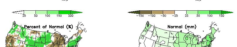
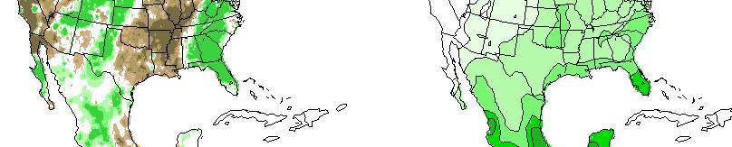
 NIDIS Weekly Climate, Water and Drought Assessment Summary Upper Colorado River Basin August 3, 2010 Precipitation and Snowpack Fig. 1: July precipitation in inches Fig. 2: July precip as percent of average
Arizona Drought Monitoring Sensitivity and Verification Analyses
 Arizona Drought Monitoring Sensitivity and Verification Analyses A Water Sustainability Institute, Technology and Research Initiative Fund Project Christopher L. Castro, Francina Dominguez, Stephen Bieda
Precipitation. Standardized Precipitation Index. NIDIS Intermountain West Regional Drought Early Warning System January 3, 2017
 1/3/2017 NIDIS Drought and Water Assessment NIDIS Intermountain West Regional Drought Early Warning System January 3, 2017 Precipitation The images above use daily precipitation statistics from NWS COOP,
HIGHLIGHTS. The majority of stations experienced above-normal rainfall in November.
 AGROMET BULLETIN Volume 5. No. 11 November 2017 HIGHLIGHTS The majority of stations experienced above-normal rainfall in November. Near-normal to above-normal rainfall is forecast for December through
Earth s Atmosphere. U.S. and Global Temperature. Drought. Heat Waves. Exosphere. Thermosphere. Mesosphere. Stratosphere. Troposphere. Shuttle.
 Weather and Earth s Atmosphere Exosphere Mesosphere Thermosphere Shuttle Aurora Meteors Stratosphere Weather balloon Troposphere Mount Everest Source: NOAA, 29 1 2 U.S. and Global Temperature Heat Waves
Current Water Conditions in Massachusetts January 11, 2008
 Current Water Conditions in Massachusetts January 11, 2008 December precipitation was above normal December streamflows were below normal and normal December ground-water levels were below normal and normal
NIDIS Intermountain West Drought Early Warning System January 16, 2018
 NIDIS Drought and Water Assessment NIDIS Intermountain West Drought Early Warning System January 16, 2018 Precipitation The images above use daily precipitation statistics from NWS COOP, CoCoRaHS, and
The MRCC and Monitoring Drought in the Midwest
 The and Monitoring Drought in the Midwest Steve Hilberg Director, Illinois State Water Survey Prairie Research Institute, University of Illinois The A partner of a national climate service program that
Historical Drought Analysis for: Northeast Oklahoma, Climate Division 3
 Historical Drought Analysis for: Northeast Oklahoma, Climate Division 3 Irenea Lodangco, Rachel Riley & Gina Fujan University of Oklahoma Prepared by the Southern Climate Impacts Planning Program November
An introduction to drought indices
 An introduction to drought indices WMO-ETSCI Workshop, Barbados 17 February 2015 Acacia Pepler Australian Bureau of Meteorology "Drought" by Tomas Castelazo - Own work. Licensed under CC BY 3.0 via Commons
NIDIS Intermountain West Drought Early Warning System January 15, 2019
 NIDIS Drought and Water Assessment NIDIS Intermountain West Drought Early Warning System January 15, 2019 Precipitation The images above use daily precipitation statistics from NWS COOP, CoCoRaHS, and
Transboundary water management with Remote Sensing. Oluf Jessen DHI Head of Projects, Water Resources Technical overview
 Transboundary water management with Remote Sensing Oluf Jessen DHI Head of Projects, Water Resources Technical overview ozj@dhigroup.com Transboundary water management Water management across national
What Can Citizen Scientists Tell Us about Drought?
 What Can Citizen Scientists Tell Us about Drought? Using CoCoRaHS to Improve the Monitoring and Reporting of Drought Impacts Amanda Farris, Kirsten Lackstrom Carolinas Integrated Sciences & Assessments
National Drought Mitigation Center. Drought Services: Collaborative Efforts Towards Drought Early Warning and Information Systems
 National Drought Mitigation Center Drought Services: Collaborative Efforts Towards Drought Early Warning and Information Systems Mark Svoboda, Climatologist Monitoring Program Area Leader National Drought
NIDIS Intermountain West Drought Early Warning System October 17, 2017
 NIDIS Drought and Water Assessment NIDIS Intermountain West Drought Early Warning System October 17, 2017 Precipitation The images above use daily precipitation statistics from NWS COOP, CoCoRaHS, and
USGS/EROS Accomplishments and Year 3 Plans. Enhancement of the U.S. Drought Monit Through the Integration of NASA Vegetation Index Imagery
 USGS/EROS Accomplishments and Year 3 Plans Enhancement of the U.S. Drought Monit Through the Integration of NASA Vegetation Index Imagery Jesslyn Brown Team Meeting, Austin, TX, 10/6/09 U.S. Department
High Resolution Indicators for Local Drought Monitoring
 High Resolution Indicators for Local Drought Monitoring REBECCA CUMBIE, STATE CLIMATE OFFICE OF NC, NCSU Monitoring Drought Multiple indicators, multiple sources Local detail important 1 Point-Based Climate-Division
Drought Criteria. Richard J. Heggen Department of Civil Engineering University of New Mexico, USA Abstract
 Drought Criteria Richard J. Heggen Department of Civil Engineering University of New Mexico, USA rheggen@unm.edu Abstract Rainwater catchment is an anticipatory response to drought. Catchment design requires
Drought Monitoring in Mainland Portugal
 Drought Monitoring in Mainland Portugal 1. Accumulated precipitation since 1st October 2014 (Hydrological Year) The accumulated precipitation amount since 1 October 2014 until the end of April 2015 (Figure
Agrometeorological activities in RHMSS
 Republic of Serbia Republic Hydrometeorological Service of Serbia Agrometeorological activities in RHMSS Department for applied climatology and agrometeorology www.hidmet.gov.rs Meteorological Observing
The Palfai Drought Index (PaDI) Expansion of applicability of Hungarian PAI for South East Europe (SEE) region Summary
 Expansion of applicability of Hungarian PAI for South East Europe (SEE) region Summary") The Palfai Drought Index () Expansion of applicability of Hungarian PAI for South East Europe (SEE) region Summary In Hungary the Palfai drought index (PAI) worked out for users in agriculture and in water
The Palfai Drought Index () Expansion of applicability of Hungarian PAI for South East Europe (SEE) region Summary In Hungary the Palfai drought index (PAI) worked out for users in agriculture and in water
DROUGHT ASSESSMENT USING SATELLITE DERIVED METEOROLOGICAL PARAMETERS AND NDVI IN POTOHAR REGION
 DROUGHT ASSESSMENT USING SATELLITE DERIVED METEOROLOGICAL PARAMETERS AND NDVI IN POTOHAR REGION Researcher: Saad-ul-Haque Supervisor: Dr. Badar Ghauri Department of RS & GISc Institute of Space Technology
NIDIS Intermountain West Regional Drought Early Warning System February 7, 2017
 NIDIS Drought and Water Assessment NIDIS Intermountain West Regional Drought Early Warning System February 7, 2017 Precipitation The images above use daily precipitation statistics from NWS COOP, CoCoRaHS,
Central Region Climate Outlook May 15, 2014
 Central Region Climate Outlook May 15, 2014 Dr. Jim Angel State Climatologist IL State Water Survey University of Illinois jimangel@illinois.edu 217-333-0729 Chicago-area flooding General Information Providing
Analysis of real-time prairie drought monitoring and forecasting system. Lei Wen and Charles A. Lin
 Analysis of real-time prairie drought monitoring and forecasting system Lei Wen and Charles A. Lin Back ground information A real-time drought monitoring and seasonal prediction system has been developed
NOAA Spring Flood Outlook for Iowa
 NOAA Spring Flood Outlook for Iowa Safeguard Iowa Partnership March 10, 2015 1 Agenda Orientation Maps Current Conditions Weather Outlook Spring Flood Outlook 2 1 Orientation Maps 3 4 2 5 Current Conditions
HIGHLIGHTS. All thirteen parishes received below-normal rainfall in July.
 AGROMET BULLETIN Volume 6. No. 7 July 2018 HIGHLIGHTS All thirteen parishes received below-normal rainfall in July. Except for Trelawny and St. Catherine, all other parishes recorded meteorological drought
NIDIS Intermountain West Drought Early Warning System January 22, 2019
 NIDIS Drought and Water Assessment NIDIS Intermountain West Drought Early Warning System January 22, 2019 Precipitation The images above use daily precipitation statistics from NWS COOP, CoCoRaHS, and
NIDIS Intermountain West Drought Early Warning System March 26, 2019
 NIDIS Intermountain West Drought Early Warning System March 26, 2019 The images above use daily precipitation statistics from NWS COOP, CoCoRaHS, and CoAgMet stations. From top to bottom, and left to right:
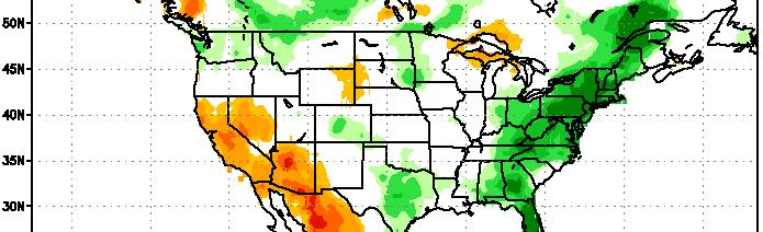
National Drought Summary July 18, 2017
 National Drought Summary July 18, 2017 The discussion in the Looking Ahead section is a description of what the official national guidance from the National Weather Service (NWS) National Centers for Environmental
LESSON 9: HOT, HOTTER, HOTTEST Extreme Weather s Impact on Our Resources
 LESSON 9: HOT, HOTTER, HOTTEST Extreme Weather s Impact on Our Resources TEACHER BACKGROUND Overview: Scientists project global warming will bring more uncertainty, potentially causing both more extremely
Weather versus Climate: What is the difference? Sources of Weather Information
 Joel O. Paz, Extension Agrometerologist and Gerrit Hoogenboom, Professor & REI Coordinator Department of Biological and Agricultural Engineering Weather versus Climate: What is the difference? The difference
Agrometeorological services in Greece
 Eleftheria Tsiniari Hellenic National Meteorological Service Operational Forecaster MSc in Meteorology MSc in Prevention and Management of Natural Disasters Email: elefth.tsiniari@gmail.com 1 Past (last
AN INSIDE LOOK AT THE U.S. DROUGHT MONITOR
 AN INSIDE LOOK AT THE U.S. DROUGHT MONITOR Great Basin Climate Forum Desert Research Institute Reno, Nevada December 6, 2018 David B. Simeral U.S. Drought Monitor Author Associate Research Scientist -
Ganbat.B, Agro meteorology Section
 NATIONAL AGENCY FOR METEOROLOGY, HYDROLOGY AND ENVIRONMENT MONITORING OF MONGOLIA Ganbat.B, Agro meteorology Section OF INSTITUTE OF METEOROLOGY AND HYDROLOGY 2009 YEAR Location Climate Northern Asia,
National Drought Summary August 14, 2018
 National Drought Summary August 14, 2018 The discussion in the Looking Ahead section is a description of what the official national guidance from the National Weather Service (NWS) National Centers for
Westmap: The Western Climate Mapping Initiative An Update
 Westmap: The Western Climate Mapping Initiative An Update Andrew Comrie 1, Kelly Redmond 2, Mary Glueck 1, Hauss Reinbold 3, Chris Daly 4 1 University of Arizona, 2 DRI / Western Regional Climate Center
The use of VIC soil moisture in drought monitoring and forecasting in Canada and China. Lei Wen 1, Charles A. Lin 1,2, Zhiyong Wu 3, Yufei Zhu 2
 The use of VIC soil moisture in drought monitoring and forecasting in Canada and China Lei Wen 1, Charles A. Lin 1,2, Zhiyong Wu 3, Yufei Zhu 2 1 2 3 VIC prairie/china soil moisture modeling three soil
4) At the end of this presentation we have an operator that will organize the Q & A s.
 At the end of this presentation we have an operator that will organize the Q & A s.") Welcome to the next in the series of central US drought status and outlook webinars through the cooperation of several regional partners including NOAA/USDA/RCCs/SCs and several other partnering groups.
Welcome to the next in the series of central US drought status and outlook webinars through the cooperation of several regional partners including NOAA/USDA/RCCs/SCs and several other partnering groups.
Unit 2 Text Worksheet # 2
 Unit 2 Text Worksheet # 2 Read Pages 74-77 1. Using fig. 5.1 on page 75 identify: Climatic Region the most widespread climatic region in the low latitudes two climatic subregions with dry conditions for
NIDIS Intermountain West Drought Early Warning System December 30, 2018
 1/2/2019 NIDIS Drought and Water Assessment NIDIS Intermountain West Drought Early Warning System December 30, 2018 Precipitation The images above use daily precipitation statistics from NWS COOP, CoCoRaHS,
Water Supply Conditions and Outlook October 1, 2018
 Water Supply Conditions and Outlook October 1, 2018 Flow Forecasting & Operations Planning Water Security Agency Overview Water supply conditions across Saskatchewan remain near normal, with most reservoirs
Creating a WeatherSMART nation: SAWS drought related research, services and products
 Creating a WeatherSMART nation: SAWS drought related research, services and products Drought Dialogue 23-24 June 2016 Western Cape Government Hannes Rautenbach South African Weather Service SAWS mandate
METEOROLOGICAL SERVICE JAMAICA CLIMATE BRANCH
 METEOROLOGICAL SERVICE JAMAICA CLIMATE BRANCH PRELIMINARY MONTHLY RAINFALL SUMMARY FOR JANUARY 2016 Introduction This rainfall summary is prepared by the Climate Branch of the Meteorological Service, Jamaica.
Midwest and Great Plains Drought and Climate Summary 20 February 2014
 Midwest and Great Plains Drought and Climate Summary 20 February 2014 Wendy Ryan Assistant State Climatologist Colorado Climate Center Colorado State University wendy.ryan@colostate.edu 970-491-8506 General
NIDIS Intermountain West Drought Early Warning System December 18, 2018
 NIDIS Intermountain West Drought Early Warning System December 18, 2018 Precipitation The images above use daily precipitation statistics from NWS COOP, CoCoRaHS, and CoAgMet stations. From top to bottom,
Assessing Drought in Agricultural Area of central U.S. with the MODIS sensor
 Assessing Drought in Agricultural Area of central U.S. with the MODIS sensor Di Wu George Mason University Oct 17 th, 2012 Introduction: Drought is one of the major natural hazards which has devastating
Local Precipitation Variability
 Local Precipitation Variability Precipitation from one storm can vary from neighborhood to neighborhood. What falls in your yard may not fall in the next. The next time it rains see how the precipitation
SOUTHERN CLIMATE MONITOR
 SOUTHERN CLIMATE MONITOR MARCH 2011 VOLUME 1, ISSUE 3 IN THIS ISSUE: Page 2 to 4 Severe Thunderstorm Climatology in the SCIPP Region Page 4 Drought Update Page 5 Southern U.S. Precipitation Summary for
Journal of Pharmacognosy and Phytochemistry 2017; 6(4): Sujitha E and Shanmugasundaram K
: Sujitha E and Shanmugasundaram K") 2017; 6(4): 452-457 E-ISSN: 2278-4136 P-ISSN: 2349-8234 JPP 2017; 6(4): 452-457 Received: 01-05-2017 Accepted: 02-06-2017 Sujitha E Research Scholar, Department of Soil and Water Conservation Engineering,
2017; 6(4): 452-457 E-ISSN: 2278-4136 P-ISSN: 2349-8234 JPP 2017; 6(4): 452-457 Received: 01-05-2017 Accepted: 02-06-2017 Sujitha E Research Scholar, Department of Soil and Water Conservation Engineering,
Drought risk assessment using GIS and remote sensing: A case study of District Khushab, Pakistan
 15 th International Conference on Environmental Science and Technology Rhodes, Greece, 31 August to 2 September 2017 Drought risk assessment using GIS and remote sensing: A case study of District Khushab,
NIDIS Intermountain West Drought Early Warning System November 13, 2018
 NIDIS Intermountain West Drought Early Warning System November 13, 2018 Precipitation The images above use daily precipitation statistics from NWS COOP, CoCoRaHS, and CoAgMet stations. From top to bottom,