The United States Drought Monitor How is it Made?
|
|
|
- Eleanor Mathews
- 6 years ago
- Views:
Transcription


1 The United States Drought Monitor How is it Made? Brian Fuchs, Climatologist National Drought Mitigation Center School of Natural Resources University of Nebraska-Lincoln September 14-17, 2009 Bamako, Mali


2 The U.S. Drought Monitor Since 1999, NOAA (CPC and NCDC), USDA, and the NDMC have produced a weekly composite drought map -- the U.S. Drought Monitor -- with input from numerous federal and non-federal partners
3 How do we get there???


4 Approaches to Drought Assessment Single index or indicator (parameter) Multiple indices or indicators Composite Indicator
5 The Drought Monitor Concept A partnership between the National Drought Mitigation Center (NDMC), the United States Department of Agriculture (USDA) and the National Oceanic and Atmospheric Administration s (NOAA) Climate Prediction Center (CPC), National Climatic Data Center (NCDC), and Regional Climate Centers (RCC) (authors) Incorporate relevant information and products from all entities (and levels of government) dealing with drought (RCC s, State Climate Offices, federal/state agencies, etc.) (local experts) The Drought Monitor is updated weekly and provides a general up-to-date summary of current drought conditions across the 50 states, Puerto Rico and the Pacific possessions
6 Drought Monitor Authors Currently 10 authors in the United States split amongst all the agencies involved. 1 Lead Author each week. This author is responsible for the production of the map and makes the final decision on all drought depictions on the map. Each author works a 2 week shift and then the responsibilities are assigned to the next author.
7 Original Objectives for the United States Drought Monitor Fujita-like scale for Drought Intensity The Drought Monitor is NOT a forecast! The Drought Monitor is NOT a drought declaration! Identify drought impacts; Agricultural (A), Hydrological (H), or both (AH) Assessment of current conditions Incorporate local expert input Being as objective as possible
8 Original Objectives for the United States Drought Monitor Fujita-like scale for Drought Intensity The Drought Monitor is NOT a forecast! The Drought Monitor is NOT a drought declaration! Identify drought impacts; Agricultural (A), Hydrological (H), or both (AH) Assessment of current conditions Incorporate local expert input Being as objective as possible
9 The Drought Monitor Concept A consolidation of indices and indicators into one comprehensive national drought map Trying to capture these characteristics: the drought s magnitude (duration + intensity) spatial extent probability of occurrence Impacts Rates drought intensity by Percentile Rankings
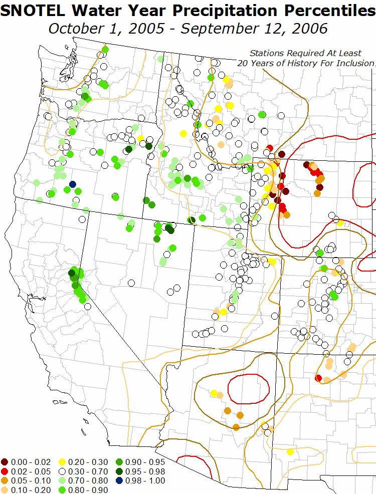
10 U.S. Drought Monitor Map Drought Intensity Categories D0 Abnormally Dry (30%tile) D1 Drought Moderate (20%tile) D2 Drought Severe (10%tile) D3 Drought Extreme (5%tile) D4 Drought Exceptional (2%tile)
 D2 Drought Severe (10%tile) D3 Drought Extreme (5%tile) D4 Drought Exceptional")
11 U.S. Drought Monitor Map Drought Intensity Categories D0 Abnormally Dry (30%tile) D1 Drought Moderate (20%tile) D2 Drought Severe (10%tile) D3 Drought Extreme (5%tile) D4 Drought Exceptional (2%tile)
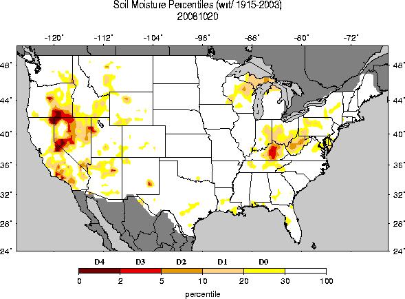
12 Key Variables For Monitoring Drought climate data soil moisture stream flow ground water reservoir and lake levels snow pack short, medium, and long range forecasts vegetation health/stress and fire danger Drought related Impacts other local drought indicators
13 Drought Monitor Timeline Day 1: Production of the next weekly map starts when the last map is published. In the United States, this is Thursday Day 2: Data and information continues to be collected and analyzed while feeback from the current map is received. In the United States, this is on Friday. Days 3-4: Not much is done over the weekend. It is at the authors discretion to continue on Saturday/Sunday. Days 5-7: Production of the Drought Monitor takes place with data for the full week and feedback from local experts considered. In the United States, the data period for the current Drought Monitor is from 12 Z Tuesday to 12 Z Tuesday, with the map being released on Thursday.
14 Drought Monitor Production (Period starts 12Z last Tuesday) Monday (Day 5) (5 Days of data available) Draft map sent to local experts Tuesday (Day 6) (6 Days of data available) Local expert feedback Draft map sent to local experts Draft text sent to local experts Wednesday (Day 7)(7 Days of data available; Local expert feedback ending 12Z yesterday) Draft map(s) sent to local experts Draft text(s) sent to local experts (Outlook) Final map and text sent to secured ftp server Thursday (Day 1 for the next week) Final map & text released on NDMC Website


15 Principal Drought Monitor Inputs USGS Streamflow CPC Daily Soil Model Palmer Drought Index SPI Drought Index USDA Soil Ratings Satellite Veg Health
16

17 These are the Local Experts

18 USDM Listserve Subscribers (Local Experts)


19 Integrates Key Drought Indicators: U.S. Drought Monitor Palmer Drought Index SPI KBDI - Modeled Soil Moisture 7-Day Avg. Streamflow Precipitation Anomalies Growing Season: Crop Moisture Index Sat. Veg. Health Index - Soil Moisture - Mesonet data In The West: SWSI Reservoir levels - Snowpack - Streamflow Created in ArcGIS

20 Indices for The West

21 Objective Blends Short-Term Blend 35% Palmer Z Index 25% 3-Month Precip. 20% 1-Month Precip. 13% CPC Soil Model 7% Palmer Drought Index

22 Objective Blends Long-Term Blend 25% Palmer Hydrological Index 20% 24-Month Precip. 20% 12-Month Precip. 15% 6-Month Precip. 10% 60-Month Precip. 10% CPC Soil Model

23 Applied Climate Information System (ACIS) is a key player..
24
25 CoCoRaHS
26 The Drought Monitor is widely used: Policy: Farm Bill/IRS/USDA/NOAA DGT/State drought plan triggers ~3.75M page views and ~2M visitors/year Media: The Weather Channel/USA Today and all major newspapers/internet Media/ Network News/ CNN/NPR/etc. Presidential/Congressional briefings NIDIS portal/portlet A model of interagency/level collaboration
27 Some Examples of Decision Making Using the DM USDA Dried Milk Program USDA CRP Release hot spot trigger Numerous states use as a drought trigger (Governor s declarations) USDA Livestock Assistance IRS (tax deferral on livestock losses) 2008 Farm Bill (NOT the only trigger) NWS Drought Information Statements (DGTs)
28 The NDMC (and DM authors) have engaged stakeholder communities : USDM/NADM Forums and surveys USDM/NADM Listservers (participatory) USDA/RMA and other projects: workshops, listening session, focus groups w/ producers/etc. (50 since 2003) Meetings w/ Media (face-to-face, conferences) Meetings at annual conferences/trade shows/etc. Meetings/briefings/workshops with/for various federal/state/tribal officials
29 Any Questions? Any Questions? Thank you! Brian Fuchs National Drought Mitigation Center
The U.S. Drought Monitor: A Composite Indicator Approach
 The U.S. Drought Monitor: A Composite Indicator Approach Mark Svoboda, Climatologist Monitoring Program Area Leader National Drought Mitigation Center School of Natural Resources University of Nebraska-Lincoln
The U.S. Drought Monitor: A Composite Indicator Approach
 The U.S. Drought Monitor: A Composite Indicator Approach Mark Svoboda, Climatologist Monitoring Program Area Leader National Drought Mitigation Center University of Nebraska-Lincoln NWS IN Climate Services
The History and Making of the U.S. Drought Monitor
 The History and Making of the U.S. Drought Monitor Mike Hayes, Director Mark Svoboda, Climatologist/Monitoring Program Area Leader Kelly Smith, Communications Specialist National Drought Mitigation Center
The U.S. Drought Monitor and tools from the National Drought Mitigation Center
 The U.S. Drought Monitor and tools from the National Drought Mitigation Center Brian Fuchs, Climatologist National Drought Mitigation Center School of Natural Resources University of Nebraska-Lincoln Winter
The U.S. Drought Monitor: Parameters, People, Process, Policy
 The U.S. Drought Monitor: Parameters, People, Process, Policy Mark Svoboda, Climatologist Monitoring Program Area Leader National Drought Mitigation Center School of Natural Resources University of Nebraska-Lincoln
Water Availability in Alaska: Using and Understanding NOAA s Drought Monitor and Drought Outlook
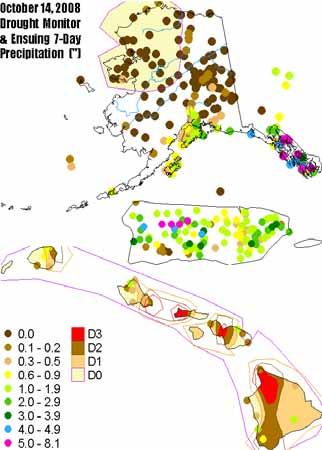
 Water Availability in Alaska: Using and Understanding NOAA s Drought Monitor and Drought Outlook Douglas Le Comte,, Drought Specialist, NOAA/NWS/Climate Prediction Center June 10, 2008 Water is Important
Drought Decision Support
 Drought Decision Support Doug Kluck Regional Climate Services Director Kansas City, MO NOAA s National Centers for Environmental Information September 12, 2018 NOAA Satellite and Information Service Mission
Funding provided by NOAA Sectoral Applications Research Project MONITORING DROUGHT. Basic Climatology Oklahoma Climatological Survey
 Funding provided by NOAA Sectoral Applications Research Project MONITORING DROUGHT Basic Climatology Oklahoma Climatological Survey DEFINING DROUGHT First off, just what is drought? Define a tornado Define
AN INSIDE LOOK AT THE U.S. DROUGHT MONITOR
 AN INSIDE LOOK AT THE U.S. DROUGHT MONITOR Great Basin Climate Forum Desert Research Institute Reno, Nevada December 6, 2018 David B. Simeral U.S. Drought Monitor Author Associate Research Scientist -
The North American Drought Monitor - The Canadian Perspective -
 The North American Drought Monitor - The Canadian Perspective - Trevor Hadwen National Agroclimate Information Service AAFC-PFRA, Regina Canmore, Alberta March 16-18, 2008 Background The NADM is a cooperative
Funding provided by NOAA Sectoral Applications Research Project MONITORING DROUGHT. Basic Climatology Colorado Climate Center
 Funding provided by NOAA Sectoral Applications Research Project MONITORING DROUGHT Basic Climatology Colorado Climate Center DEFINING DROUGHT First off, just what is drought? Define a tornado Define a
New Assessment Tools in Monitoring Drought
 New Assessment Tools in Monitoring Drought David Miskus Supervisory Meteorologist Joint Agricultural Weather Facility, Climate Prediction Center, NCEP/NWS/NOAA Washington, D.C. David.Miskus@noaa.gov Prepared
National Drought Mitigation Center. Drought Services: Collaborative Efforts Towards Drought Early Warning and Information Systems
 National Drought Mitigation Center Drought Services: Collaborative Efforts Towards Drought Early Warning and Information Systems Mark Svoboda, Climatologist Monitoring Program Area Leader National Drought
Drought and Climate Extremes Indices for the North American Drought Monitor and North America Climate Extremes Monitoring System. Richard R. Heim Jr.
 Drought and Climate Extremes Indices for the North American Drought Monitor and North America Climate Extremes Monitoring System Richard R. Heim Jr. NOAA/NESDIS/National Climatic Data Center Asheville,
NIDIS Intermountain West Drought Early Warning System October 17, 2017
 NIDIS Drought and Water Assessment NIDIS Intermountain West Drought Early Warning System October 17, 2017 Precipitation The images above use daily precipitation statistics from NWS COOP, CoCoRaHS, and
NIDIS Intermountain West Drought Early Warning System May 23, 2017
 NIDIS Drought and Water Assessment NIDIS Intermountain West Drought Early Warning System May 23, 2017 Precipitation The images above use daily precipitation statistics from NWS COOP, CoCoRaHS, and CoAgMet
Precipitation. Standardized Precipitation Index. NIDIS Intermountain West Drought Early Warning System September 5, 2017
 9/6/2017 NIDIS Drought and Water Assessment NIDIS Intermountain West Drought Early Warning System September 5, 2017 Precipitation The images above use daily precipitation statistics from NWS COOP, CoCoRaHS,
CARIWIN Regional Seminar January 14-15, 2010, Georgetown, Guyana
 Creating the North American Drought Monitor Angel (Bennett) McCoy Angel.M.Bennett@noaa.gov NOAA/Climate Prediction Center Camp Springs, Maryland, U.S.A. Doug LeComte NOAA/Climate Prediction Center Richard
NIDIS Intermountain West Drought Early Warning System September 4, 2018
 NIDIS Drought and Water Assessment NIDIS Intermountain West Drought Early Warning System September 4, 2018 Precipitation The images above use daily precipitation statistics from NWS COOP, CoCoRaHS, and
NIDIS Intermountain West Drought Early Warning System March 26, 2019
 NIDIS Intermountain West Drought Early Warning System March 26, 2019 The images above use daily precipitation statistics from NWS COOP, CoCoRaHS, and CoAgMet stations. From top to bottom, and left to right:
NIDIS Intermountain West Drought Early Warning System November 13, 2018
 NIDIS Intermountain West Drought Early Warning System November 13, 2018 Precipitation The images above use daily precipitation statistics from NWS COOP, CoCoRaHS, and CoAgMet stations. From top to bottom,
The National Integrated Drought Information System (NIDIS) Moving the Nation from Reactive to Proactive Drought Risk Management
 Moving the Nation from Reactive to Proactive Drought Risk Management") The National Integrated Drought Information System (NIDIS) Moving the Nation from Reactive to Proactive Drought Risk Management CSG-West Annual Meeting Agriculture & Water Committee Snowbird, UT September
The National Integrated Drought Information System (NIDIS) Moving the Nation from Reactive to Proactive Drought Risk Management CSG-West Annual Meeting Agriculture & Water Committee Snowbird, UT September
NIDIS Intermountain West Drought Early Warning System July 18, 2017
 NIDIS Drought and Water Assessment NIDIS Intermountain West Drought Early Warning System July 18, 2017 Precipitation The images above use daily precipitation statistics from NWS COOP, CoCoRaHS, and CoAgMet
NIDIS Intermountain West Drought Early Warning System January 16, 2018
 NIDIS Drought and Water Assessment NIDIS Intermountain West Drought Early Warning System January 16, 2018 Precipitation The images above use daily precipitation statistics from NWS COOP, CoCoRaHS, and
NOAA S2S Planning. Dave DeWitt Fred Toepfer
 NOAA S2S Planning Dave DeWitt Fred Toepfer 1 Agenda 1. Brief synopsis of The Weather Research and Forecasting Act of 2017 2. Report to Congress a. Timeline b. Process c. Document Outline 3. Some Preliminary
NIDIS Intermountain West Drought Early Warning System April 16, 2019
 NIDIS Intermountain West Drought Early Warning System April 16, 2019 Precipitation The images above use daily precipitation statistics from NWS COOP, CoCoRaHS, and CoAgMet stations. From top to bottom,
NIDIS Intermountain West Drought Early Warning System February 6, 2018
 NIDIS Intermountain West Drought Early Warning System February 6, 2018 Precipitation The images above use daily precipitation statistics from NWS COOP, CoCoRaHS, and CoAgMet stations. From top to bottom,
NADM, NACEM, and Opportunities for Future Collaboration
 NADM, NACEM, and Opportunities for Future Collaboration Richard R. Heim Jr. NOAA/NESDIS/National Climatic Data Center Asheville, North Carolina, U.S.A. 4th Annual DRI Workshop 26-28 January 2009, Regina,
NIDIS Intermountain West Drought Early Warning System December 11, 2018
 NIDIS Drought and Water Assessment NIDIS Intermountain West Drought Early Warning System December 11, 2018 Precipitation The images above use daily precipitation statistics from NWS COOP, CoCoRaHS, and
Improving Drought Forecasts: The Next Generation of Seasonal Outlooks
 Improving Drought Forecasts: The Next Generation of Seasonal Outlooks Douglas Le Comte, CPC Douglas.lecomte@noaa.gov Outline Review of how the current Drought Outlooks are made Sample experimental products
GIS Tools, Data, & Methods in the Weekly US Drought Monitor
 GIS Tools, Data, & Methods in the Weekly US Drought Monitor International Workshop on Agromet and GIS Applications for Agricultural Decision Making Jeju, South Korea December 5, 2016 Eric Luebehusen USDA/OCE/WAOB
NIDIS Drought and Water Assessment
 NIDIS Drought and Water Assessment PRECIPITATION The images above use daily precipitation statistics from NWS COOP, CoCoRaHS, and CoAgMet stations. From top to bottom, and left to right: most recent 7-days
NIDIS Intermountain West Drought Early Warning System December 18, 2018
 NIDIS Intermountain West Drought Early Warning System December 18, 2018 Precipitation The images above use daily precipitation statistics from NWS COOP, CoCoRaHS, and CoAgMet stations. From top to bottom,
NIDIS Intermountain West Drought Early Warning System November 21, 2017
 NIDIS Drought and Water Assessment NIDIS Intermountain West Drought Early Warning System November 21, 2017 Precipitation The images above use daily precipitation statistics from NWS COOP, CoCoRaHS, and
NIDIS Intermountain West Drought Early Warning System August 8, 2017
 NIDIS Drought and Water Assessment 8/8/17, 4:43 PM NIDIS Intermountain West Drought Early Warning System August 8, 2017 Precipitation The images above use daily precipitation statistics from NWS COOP,
NIDIS Intermountain West Drought Early Warning System November 14, 2017
 NIDIS Intermountain West Drought Early Warning System November 14, 2017 Precipitation The images above use daily precipitation statistics from NWS COOP, CoCoRaHS, and CoAgMet stations. From top to bottom,
North Central U.S. Climate Summary and Outlook Webinar December 15, 2016
 North Central U.S. Climate Summary and Outlook Webinar December 15, 2016 Stuart Foster State Climatologist for Kentucky Department of Geography and Geology Western Kentucky University Stuart.foster@wku.edu
Indices and Indicators for Drought Early Warning
 Indices and Indicators for Drought Early Warning ADRIAN TROTMAN CHIEF, APPLIED METEOROLOGY AND CLIMATOLOGY CARIBBEAN INSTITUTE FOR METEOROLOGY AND HYDROLOGY IN COLLABORATION WITH THE NATIONAL DROUGHT MITIGATION
NIDIS Intermountain West Drought Early Warning System May 1, 2018
 NIDIS Intermountain West Drought Early Warning System May 1, 2018 Precipitation The images above use daily precipitation statistics from NWS COOP, CoCoRaHS, and CoAgMet stations. From top to bottom, and
NIDIS Intermountain West Drought Early Warning System October 30, 2018
 10/30/2018 NIDIS Drought and Water Assessment NIDIS Intermountain West Drought Early Warning System October 30, 2018 Precipitation The images above use daily precipitation statistics from NWS COOP, CoCoRaHS,
High Resolution Indicators for Local Drought Monitoring
 High Resolution Indicators for Local Drought Monitoring REBECCA CUMBIE, STATE CLIMATE OFFICE OF NC, NCSU Monitoring Drought Multiple indicators, multiple sources Local detail important 1 Point-Based Climate-Division
Behind the Climate Prediction Center s Extended and Long Range Outlooks Mike Halpert, Deputy Director Climate Prediction Center / NCEP
 Behind the Climate Prediction Center s Extended and Long Range Outlooks Mike Halpert, Deputy Director Climate Prediction Center / NCEP September 2012 Outline Mission Extended Range Outlooks (6-10/8-14)
Precipitation. Standardized Precipitation Index. NIDIS Intermountain West Regional Drought Early Warning System January 3, 2017
 1/3/2017 NIDIS Drought and Water Assessment NIDIS Intermountain West Regional Drought Early Warning System January 3, 2017 Precipitation The images above use daily precipitation statistics from NWS COOP,
NOAA and Partners Midwest and Great Plains Drought Update Webinar
 NOAA and Partners Midwest and Great Plains Drought Update Webinar Brian Fuchs National Drought Mitigation Center School of Natural Resources University of Nebraska-Lincoln NOAA Webinar Series, July 18,
NIDIS Intermountain West Drought Early Warning System January 22, 2019
 NIDIS Drought and Water Assessment NIDIS Intermountain West Drought Early Warning System January 22, 2019 Precipitation The images above use daily precipitation statistics from NWS COOP, CoCoRaHS, and
Drought Impacts in the Southern Great Plains. Mark Shafer University of Oklahoma Norman, OK
 Drought Impacts in the Southern Great Plains Mark Shafer University of Oklahoma Norman, OK Causes of Drought: Large-Scale, Stationary High Pressure Air rotates clockwise around high pressure steers storms
NIDIS Intermountain West Drought Early Warning System December 30, 2018
 1/2/2019 NIDIS Drought and Water Assessment NIDIS Intermountain West Drought Early Warning System December 30, 2018 Precipitation The images above use daily precipitation statistics from NWS COOP, CoCoRaHS,
Great Plains and Midwest Drought Impacts and Outlook May 16, 2013
 Great Plains and Midwest Drought Impacts and Outlook May 16, 2013 Dr. Martha Shulski Director, High Plains Regional Climate Center University of Nebraska - Lincoln mshulski3@unl.edu 402-472-6711 May snow
NIDIS Intermountain West Regional Drought Early Warning System February 7, 2017
 NIDIS Drought and Water Assessment NIDIS Intermountain West Regional Drought Early Warning System February 7, 2017 Precipitation The images above use daily precipitation statistics from NWS COOP, CoCoRaHS,
Central Region Climate Outlook May 15, 2014
 Central Region Climate Outlook May 15, 2014 Dr. Jim Angel State Climatologist IL State Water Survey University of Illinois jimangel@illinois.edu 217-333-0729 Chicago-area flooding General Information Providing
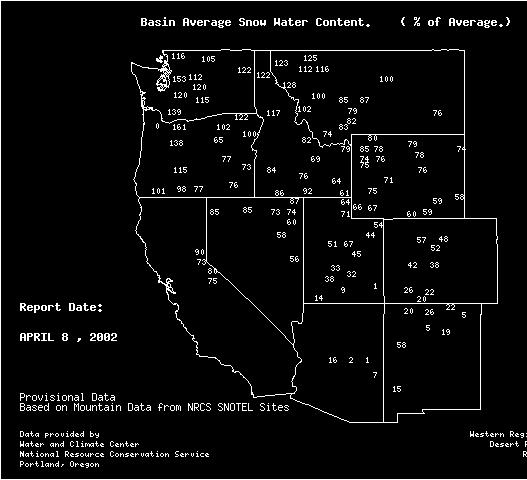
Oregon Water Conditions Report April 17, 2017
 Oregon Water Conditions Report April 17, 2017 Mountain snowpack continues to maintain significant levels for mid-april. By late March, statewide snowpack had declined to 118 percent of normal after starting
The MRCC and Monitoring Drought in the Midwest
 The and Monitoring Drought in the Midwest Steve Hilberg Director, Illinois State Water Survey Prairie Research Institute, University of Illinois The A partner of a national climate service program that
NIDIS Intermountain West Drought Early Warning System February 12, 2019
 NIDIS Intermountain West Drought Early Warning System February 12, 2019 Precipitation The images above use daily precipitation statistics from NWS COOP, CoCoRaHS, and CoAgMet stations. From top to bottom,
Weekly Weather Briefing. NWS Albuquerque. Tuesday Soaker. NWS Albuquerque August 25, Weekly Weather Briefing
 Weekly Weather Briefing Weekly Weather Briefing Tuesday Soaker August 25, 2014 August 2014 vs. 2013 Precipitation Percent of Average August 1-24, 2014 August 2013 Weekly Weather Briefing ABQ **Preliminary**
The U.S. National Integrated Drought Information System. Roger S. Pulwarty National Oceanic and Atmospheric Administration USA
 The U.S. National Integrated Drought Information System Roger S. Pulwarty National Oceanic and Atmospheric Administration USA Drought: Weather-climate continuum and adaptation deficits 2010 2011 2012 2015
What Can Citizen Scientists Tell Us about Drought?
 What Can Citizen Scientists Tell Us about Drought? Using CoCoRaHS to Improve the Monitoring and Reporting of Drought Impacts Amanda Farris, Kirsten Lackstrom Carolinas Integrated Sciences & Assessments
NIDIS Intermountain West Drought Early Warning System February 19, 2019
 NIDIS Intermountain West Drought Early Warning System February 19, 2019 Precipitation The images above use daily precipitation statistics from NWS COOP, CoCoRaHS, and CoAgMet stations. From top to bottom,
Wind River Indian Reservation and Surrounding Area Climate and Drought Summary
 Northern Arapaho Tribe Wind River Indian Reservation and Surrounding Area Climate and Drought Summary Summer Events & Fall Outlook 2015 Summer Was Near, Precipitation Was Highly Variable Across The Region
NIDIS Intermountain West Drought Early Warning System January 15, 2019
 NIDIS Drought and Water Assessment NIDIS Intermountain West Drought Early Warning System January 15, 2019 Precipitation The images above use daily precipitation statistics from NWS COOP, CoCoRaHS, and
COMPARISON OF DROUGHT INDICES AND SC DROUGHT ALERT PHASES
 COMPARISON OF DROUGHT INDICES AND SC DROUGHT ALERT PHASES Ekaterina Altman 1 AUTHORS : 1 Master of Environmental Resource Management Candidate, Environment and Sustainability Program, University of South
The Kentucky Mesonet: Entering a New Phase
 The Kentucky Mesonet: Entering a New Phase Stuart A. Foster State Climatologist Kentucky Climate Center Western Kentucky University KCJEA Winter Conference Lexington, Kentucky February 9, 2017 Kentucky
Regional Drought Decision Support System (RDDSS) Project Update and Product Concepts
 Project Update and Product Concepts") Regional Drought Decision Support System (RDDSS) Project Update and Product Concepts Part of the Red River Basin Decision Information Network (RRBDIN) NEXT-GEN RRBDIN Decision Support for the Red River
Regional Drought Decision Support System (RDDSS) Project Update and Product Concepts Part of the Red River Basin Decision Information Network (RRBDIN) NEXT-GEN RRBDIN Decision Support for the Red River
Drought, A Global Perspective: Efforting Toward a Global Drought Early Warning System
 Drought, A Global Perspective: Efforting Toward a Global Drought Early Warning System Mark Svoboda, Climatologist Monitoring Program Area Leader National Drought Mitigation Center University of Nebraska-Lincoln
NIDIS Intermountain West Drought Early Warning System April 24, 2018
 NIDIS Intermountain West Drought Early Warning System April 24, 2018 Precipitation The images above use daily precipitation statistics from NWS COOP, CoCoRaHS, and CoAgMet stations. From top to bottom,
An introduction to drought indices
 An introduction to drought indices WMO-ETSCI Workshop, Barbados 17 February 2015 Acacia Pepler Australian Bureau of Meteorology "Drought" by Tomas Castelazo - Own work. Licensed under CC BY 3.0 via Commons
NIDIS Intermountain West Drought Early Warning System December 4, 2018
 12/4/2018 NIDIS Drought and Water Assessment NIDIS Intermountain West Drought Early Warning System December 4, 2018 Precipitation The images above use daily precipitation statistics from NWS COOP, CoCoRaHS,
NIDIS Intermountain West Drought Early Warning System April 18, 2017
 1 of 11 4/18/2017 3:42 PM Precipitation NIDIS Intermountain West Drought Early Warning System April 18, 2017 The images above use daily precipitation statistics from NWS COOP, CoCoRaHS, and CoAgMet stations.
North Central U.S. Climate Summary and Outlook Webinar July 21, 2016
 North Central U.S. Climate Summary and Outlook Webinar July 21, 2016 Stuart Foster State Climatologist for Kentucky Department of Geography and Geology Western Kentucky University Stuart.foster@wku.edu
Wind River Indian Reservation and Surrounding Area Climate and Drought Summary
 Northern Arapaho Tribe Wind River Indian Reservation and Surrounding Area Climate and Drought Summary Spring Events & Summer Outlook 2015 Spring Was Warm And Very Wet Across The Region The spring season
Michael B. Ek 1, Youlong Xia 1,2, Jesse Meng 1,2, and Jiarui Dong 1,2
 Michael B. Ek 1, Youlong Xia 1,2, Jesse Meng 1,2, and Jiarui Dong 1,2 1 Land-Hydrology Team Environmental Modeling Center (EMC) National Centers for Environmental Prediction (NCEP) National Weather Service
PRECIPITATION. Last Week Precipitation:
 12/3/2014 NIDIS Drought and Water Assessment PRECIPITATION The images above use daily precipitation statistics from NWS COOP, CoCoRaHS, and CoAgMet stations. From top to bottom, and left to right: most
Midwest and Great Plains Climate- Drought Outlook 20 April 2017
 Midwest and Great Plains Climate- Drought Outlook 20 April 2017 Dr. Dennis Todey Director USDA Midwest Climate Hub Nat l Lab. for Ag. and Env. Ames, IA dennis.todey@ars.usda.gov 515-294-2013 Photo: BJ
Midwest/Great Plains Climate-Drought Outlook August 17, 2017
 Midwest/Great Plains Climate-Drought Outlook August 17, 2017 Brian Fuchs National Drought Mitigation Center University of Nebraska-Lincoln School of Natural Resources General Information Providing climate
Oregon Water Conditions Report May 1, 2017
 Oregon Water Conditions Report May 1, 2017 Mountain snowpack in the higher elevations has continued to increase over the last two weeks. Statewide, most low and mid elevation snow has melted so the basin
Precipitation. Standardized Precipitation Index. NIDIS Intermountain West Regional Drought Early Warning System December 6, 2016
 12/9/2016 NIDIS Drought and Water Assessment NIDIS Intermountain West Regional Drought Early Warning System December 6, 2016 Precipitation The images above use daily precipitation statistics from NWS COOP,
Using ArcGIS 10 to Estimate the U.S. Population Affected by Drought
 Using ArcGIS 10 to Estimate the U.S. Population Affected by Drought Jeff Nothwehr National Drought Mitigation Center University of Nebraska-Lincoln Overview What is the U.S. Drought Monitor Mapping Process
Climate Impacts to Southwest Water Sector. Dr. Dave DuBois New Mexico State Climatologist
 Climate Impacts to Southwest Water Sector Dr. Dave DuBois New Mexico State Climatologist Presented at EPA Extreme Events and Climate Adaptation Planning Workshop June 3, 2015 Water Year Precip. % of Average
Midwest and Great Plains Climate- Drought Outlook 16 April 2015
 Midwest and Great Plains Climate- Drought Outlook 16 April 2015 Dr. Dennis Todey State Climatologist South Dakota State Univ. dennis.todey@sdstate.edu 605-688-5141 Photo taken Feb 19, 2013 Wildfire Wind
Condition Monitoring: A New System for Drought Impacts Reporting through CoCoRaHS
 Condition Monitoring: A New System for Drought Impacts Reporting through CoCoRaHS Amanda Farris Carolinas Integrated Sciences & Assessments (CISA) University of South Carolina WERA 1012 Annual Conference
PRECIPITATION. Last Week Precipitation:
 PRECIPITATION The images above use daily precipitation statistics from NWS COOP, CoCoRaHS, and CoAgMet stations. From top to bottom, and left to right: most recent 7-days of accumulated precipitation in
Brian McGurk, P.G. DEQ Office of Water Supply. Contents. Overview of Virginia s Drought Assessment & Response Plan
 Drought Preparedness in Virginia Or, Whatcha Gonna Do When the Well, Creek, River, or Reservoir (Might) Run Dry? Rappahannock-Rapidan Regional Commission Living Lands Workshop November 18, 2014 Brian McGurk,
UNITED STATES AND SOUTH AMERICA OUTLOOK (FULL REPORT) Thursday, December 28, 2017
 Thursday, December 28, 2017") T-storm Weather Summary Despite scattered t-storms Sat.-Sun. in central and northern areas in Argentina, more will likely be needed especially in sunflower areas of the southwest. Some t-storms likely
T-storm Weather Summary Despite scattered t-storms Sat.-Sun. in central and northern areas in Argentina, more will likely be needed especially in sunflower areas of the southwest. Some t-storms likely
Applications/Users for Improved S2S Forecasts
 Applications/Users for Improved S2S Forecasts Nolan Doesken Colorado Climate Center Colorado State University WSWC Precipitation Forecasting Workshop June 7-9, 2016 San Diego, CA First -- A short background
Arizona Drought Monitoring Sensitivity and Verification Analyses
 Arizona Drought Monitoring Sensitivity and Verification Analyses A Water Sustainability Institute, Technology and Research Initiative Fund Project Christopher L. Castro, Francina Dominguez, Stephen Bieda
Great Plains and Midwest Climate Outlook 18 December 2014
 Great Plains and Midwest Climate Outlook 18 December 2014 Wendy Ryan Assistant State Climatologist Colorado State University wendy.ryan@colostate.edu 30 Nov 2014 Looking down at the Yampa Valley near Steamboat
CoCoRaHS Condition Monitoring. Webinar with Carolinas Observers January 25, 2017
 CoCoRaHS Condition Monitoring Webinar with Carolinas Observers January 25, 2017 Amanda Kirsten David Ellie & Meghan Project Partners CoCoRaHS Condition Monitoring Overview Regular reports describing how
Central Region Climate Outlook March20, 2014
 Central Region Climate Outlook March20, 2014 Dr. Jim Angel State Climatologist IL State Water Survey University of Illinois jimangel@illinois.edu 217-333-0729 Happy Spring Equinox! General Information
Drought History. for the Low Rolling Plains of Texas. Prepared by the South Central Climate Science Center in Norman, Oklahoma
 Drought History for the Low Rolling Plains of Texas Prepared by the South Central Climate Science Center in Norman, Oklahoma May 28, 2013 http://southcentralclimate.org/ info@southcentralclimate.org (This
Midwest and Great Plains Climate- Drought Outlook 20 October 2016
 Midwest and Great Plains Climate- Drought Outlook 20 October 2016 Laura Edwards Acting State Climatologist SDSU Extension, Aberdeen, SD Laura.edwards@sdstate.edu 605-626-2870 Cottonwood Fire 17 Oct 2016
Drought History. for the Edwards Plateau of Texas. Prepared by the South Central Climate Science Center in Norman, Oklahoma
 Drought History for the Edwards Plateau of Texas Prepared by the South Central Climate Science Center in Norman, Oklahoma May 28, 2013 http://southcentralclimate.org/ info@southcentralclimate.org (This
Midwest and Great Plains Climate & Drought Outlook 16 November 2017
 Midwest and Great Plains Climate & Drought Outlook 16 November 2017 Jim Angel IL State Climatologist University of Illinois Champaign, IL jimangel@illinois.edu 217-333-0729 Harvest underway in Illinois
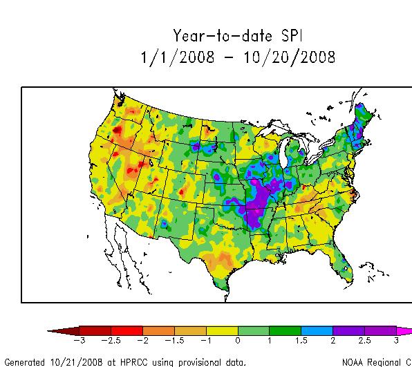
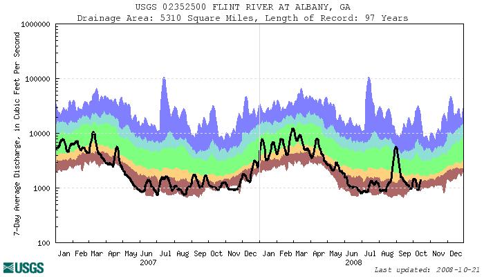
Current Water Conditions in Massachusetts January 11, 2008
 Current Water Conditions in Massachusetts January 11, 2008 December precipitation was above normal December streamflows were below normal and normal December ground-water levels were below normal and normal
Wind River Indian Reservation and Surrounding Area Climate and Drought Summary
 Northern Arapaho Tribe Wind River Indian Reservation and Surrounding Area Climate and Drought Summary Fall Events & Winter Outlook 2016-2017 Warm And Wet Fall The fall season was warm and very wet throughout
Wind River Indian Reservation and Surrounding Area Climate and Drought Summary
 Northern Arapaho Tribe Wind River Indian Reservation and Surrounding Area Climate and Drought Summary Spring Events & Summer Outlook 2016 Wet Spring Leads To Flooding Spring was very wet across most of
NIDIS Weekly Climate, Water and Drought Assessment Summary. Upper Colorado River Basin
 NIDIS Weekly Climate, Water and Drought Assessment Summary Upper Colorado River Basin August 3, 2010 Precipitation and Snowpack Fig. 1: July precipitation in inches Fig. 2: July precip as percent of average
Midwest and Great Plains Climate- Drought Outlook 21 August 2014
 Midwest and Great Plains Climate- Drought Outlook 21 August 2014 Dr. Jeff Andresen State Climatologist Michigan State University andresen@msu.edu 517-432-4756 Flooding along I-696 in Warren, MI 11 AUG
NATIONAL WATER RESOURCES OUTLOOK
 NATIONAL WATER RESOURCES OUTLOOK American Meteorological Society Annual Meeting 24 th Hydrology Conference 9.2 James Noel Service Coordination Hydrologist National Weather Service-Ohio River Forecast Center
PRECIPITATION. Last Week Precipitation:
 PRECIPITATION The images above use daily precipitation statistics from NWS COOP, CoCoRaHS, and CoAgMet stations. From top to bottom, and left to right: most recent 7-days of accumulated precipitation in
Regional Consultative Workshop on
 Regional Consultative Workshop on El Niño in Asia-Pacific Country Presentation of Myanmar 7-9 June 2016 Bangkok, Thailand El Niño Impact (Myanmar Aspect) The impacts of El Nino event on the climate and
NIDIS Drought and Water Assessment
 7/23/13 1:57 PM PRECIPITATION The images above use daily precipitation statistics from NWS COOP, CoCoRaHS, and CoAgMet stations. From top to bottom, and left to right: most recent 7-days of accumulated