Caribbean Tropical Cyclone Modeling
|
|
|
- Sabrina Pierce
- 5 years ago
- Views:
Transcription

1 Caribbean Tropical Cyclone Modeling Filmon Habte, PhD 2018 RAA Catastrophe Risk Management Conference Orlando, Florida February 14, 2018
2 Agenda Hurricane risk in the Caribbean 2017 hurricane season Lessons from KCC post disaster surveys KCC Tropical Cyclone Reference Model for the Caribbean 2

3 Hurricane Risk In the Caribbean ~ 2.5 Hurricanes per year ~ 1.9 Hurricanes per year affect at least one Caribbean island 21 CAT 4 and CAT 5 Hurricanes in the Caribbean Since 2000 Different islands have different vulnerabilities based on economics, building practices, etc. 3
 resulted in extensive damage throughout the Caribbean 1 Major Hurricane (Jose) passed just to the north of the Leeward")
4 The 2017 Hurricane Season 5 th most active season since 1851 Highest number of major hurricanes since 2005 Costliest season in the Caribbean 3 Tropical Storms (Phillippe, Bret, Harvey) impacted Caribbean Islands Jose 2 Landfalling Major Hurricanes (Maria and Irma) resulted in extensive damage throughout the Caribbean 1 Major Hurricane (Jose) passed just to the north of the Leeward Islands 4
 Wide divergence in modeler loss estimates Initial Modeler Estimates of Maria Losses in")
5 Hurricane Maria (2017) in the Caribbean Second Category 5 hurricane to impact the Leeward Islands within a month Maria intensified from CAT1 to CAT5 in 15 hours (Second to Hurricane Wilma) Wide divergence in modeler loss estimates Initial Modeler Estimates of Maria Losses in PR 5
6 KCC Hurricane Maria Modeled Insured Losses in the Caribbean Puerto Rico United States Virgin Islands Dominica Guadeloupe Dominican Republic Martinique British Virgin Islands Saint Lucia $26500 M $800 M $400 M $35 M $10 M $8 M $5 M $3 M Majority of loss in Puerto Rico was to commercial structures KCC conducted detailed damage survey in Puerto Rico Comparison of Modeled and PCS Losses for Puerto Rico LOB KCC Modeled Loss PCS Losses AUT $0.32 B $0.37 B Antigua and Barbuda St Kitts and Nevis $2 M $1 M COM IND $21 B $2.78 B $19.2 B Sint Maarten Saint-Martin $1 M $1 M RES $2.40 B $2.36 B 6


7 KCC s Hurricane Maria Post Disaster Survey in Puerto Rico Independent damage survey Arecibo San Juan Fajardo Humacao Ponce Post Disaster Survey Survey and discussion with claims adjustors Review of actual claims files 7

8 Residential Building Damage Varied by Building Type 8


9 Residential Reinforced Concrete Buildings Performed Well Wall stucco damage and peeling paint Water infiltration induced damage Damage to doors and windows Damage to lighting fixtures Damage to sheds, fences and gates 9

10 Roof Tiles on Concrete Slabs Vertical Wind Profile 10


11 Wood-Frame and Mixed Construction In mixed construction, damage limited to the wood frame part Wood frame buildings performed poorly Corrugated zinc sheet roofs performed poorly 11

12 Wood-Frame and Mixed Construction in Low Wind Speeds 12


13 Different Commercial Constructions and Occupancies were Surveyed Schools and Universities Airport Restaurants Retail Stadiums and Sport Arenas 13


14 Observed Relative Vulnerability of Commercial Buildings Gas Stations performed poorly Low-rise RC apartments performed well 14


15 Low and Mid-Rise Apartments and Condos A significant portion of the low-rise apartment buildings in Puerto Rico are constructed using reinforced concrete, hence they experienced minimal structural damage Damage to Balcony Elements Damage to Decorative Tile 15


16 High-Rise Apartments and Condos Steel frame structures with EIFS cladding Frequent damage to balcony doors and windows was observed Most of this damage occurred because of weak door/window wall frame systems 16


17 Low-Rise Office Buildings Many low-rise offices experienced damage to EIFS and stucco claddings Significant damage to windows, including their frames 17


18 High-Rise Office Buildings Damage to cladding of tall buildings constructed with glass Damage due to high pressure Damage to mechanical systems including elevators 18


19 High-Rise Office Building Interior Damage Estimated total cost to repair ~ 25% of building value Insurers pay financial loss i.e. the cost to repair (usually higher than new construction) 19


20 Chain Pharmacies, Restaurants, Malls and Shopping Centers in Low Speeds Damage to such structures was prevalent, even in low wind speeds Low-quality of building finishing and lack of attention to details were observed 20


21 Chain Pharmacies, Restaurants, Malls and Shopping Centers in High Speeds Even small roof, wall or window openings can lead to heavy building interior and contents damage 21


22 Limited Damage to Industrial Buildings Damage limited to steel structures with metal roofs 22


23 Damage to Sources of Renewable Energy The wind turbines became operational in 2012 were designed to withstand wind gusts of 134 mph More than 70% of the solar panels experienced significant damage Punta Lima Wind Farm Fonroche Solar Farm 23

24 Caribbean Hurricane Loss Model Framework 24
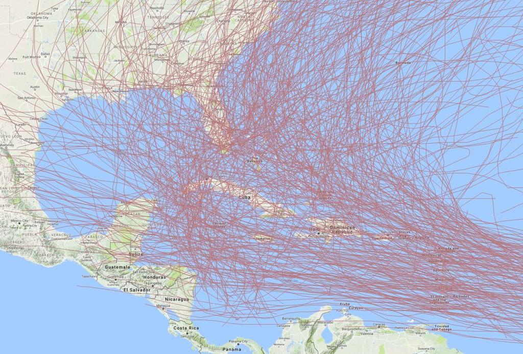
25 Historical Hurricanes in the Caribbean Basin Since
 including Maximum wind speed (Vmax) Radius to maximum speed (Rmax) Forward speed Track A rate is assigned to each event 26")
26 Characteristic Event (CE) Approach for Catalog Generation The basin is divided into regions and historical hurricane data are analyzed separately for each region Each event in a region is assigned appropriate parameters defining the characteristics of that region (i.e. Characteristic Events) including Maximum wind speed (Vmax) Radius to maximum speed (Rmax) Forward speed Track A rate is assigned to each event 26
 for one region CE s corresponding to 3, 4, 5, 10, 20, 50, 100, 250, 500 years are")
27 Maximum Wind Speed (Vmax) Each hurricane is assigned a Vmax based on its return period and region The chart below shows the historical data (blue diamonds) along with the Vmax selected for the return period events (red squares) for one region CE s corresponding to 3, 4, 5, 10, 20, 50, 100, 250, 500 years are derived 27

 and loss costs at high resolution, including")
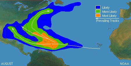
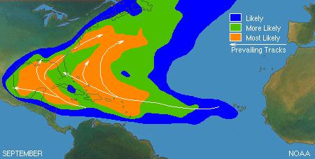
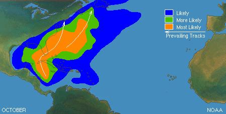
28 Modeling of Storm Tracks Primary track is the most typical track for that region There must be a smooth transition between tracks Enables robust calculations of Average Annual Losses (AALs) and loss costs at high resolution, including location level 28


29 Caribbean and US Models are Integrated A proportion of tracks impact the Caribbean and the US Hurricane San Felipe II / Okeechobee (1928) 29


30 Validation of Event Magnitudes and Rates TS CAT1 CAT2 CAT3 CAT4 CAT5 TS CAT1 CAT2 CAT3 CAT4 CAT5 TS CAT1 CAT2 CAT3 CAT4 CAT5 TS CAT1 CAT2 CAT3 CAT4 CAT5 TS CAT1 CAT2 CAT3 CAT4 CAT5 TS CAT1 CAT2 CAT3 CAT4 CAT5 TS CAT1 CAT2 CAT3 CAT4 CAT5 TS CAT1 CAT2 CAT3 CAT4 CAT5 TS CAT1 CAT2 CAT3 CAT4 CAT5 30

31 Generation of the Hurricane Windfield The Willoughby wind profile model used to develop the windfield Asymmetry in the windfield dependent on the forward speed and wind inflow angle Asymmetry in the wind profile Inflow Angle 31


 E E Direction dependent topography")
32 Addressing Effect of Surface Roughness and Local Topography Surface Roughness Land Use Land Cover Data Develop effective roughness lengths Surface Roughness N Topography N Direction dependent surface friction factors Local Topography High resolution elevation data (30 m) E E Direction dependent topography factors S S 32


 Hurricane")
33 Validation of Hurricane Footprints Wind speed are limited and observations need to be standardized before used Wind observations can have errors of 10-15% Anemometers fail at high wind speeds Hurricane Ivan (2005) Hurricane Georges (1998) Hurricane Marilyn (1991) Hurricane Hugo (1989) 33
34 VULNERABILITY Vulnerability Relativities Between Different Islands Building stock Type of buildings Construction practices Year built Building codes and enforcement Economic level Haiti : : : Dominican Republic Jamaica : : USVI and Bahamas : : Puerto Rico 34
 Comparison")


35 Hurricane Maria and Hurricane San Felipe II (1928) Comparison Hurricane San Felipe II (1928) CAT 5 at landfall Modelled loss ~ $25.5 Billion Hurricane Maria (2017) CAT 4 at landfall Modelled loss ~ $26.5 Billion 35
36 Summary and Conclusion The Caribbean Region is highly active with respect to tropical cyclone frequency and severity Hurricane Maria clearly illustrated the differences in the vendor models and loss estimates In Puerto Rico, commercial properties dominate the insured loss potential The KCC Tropical Cyclone Reference Model for the Caribbean produces credible and reliable EP curves as well as accurate loss estimates for actual events 36
HURRICANE MARIA PUERTO RICO ASSESSMENT FOUR & SIX MONTHS POST LANDFALL. January & March 2018
 HURRICANE MARIA PUERTO RICO ASSESSMENT FOUR & SIX MONTHS POST LANDFALL January & March 2018 CONCLUSIONS OF FIELD RECON JANUARY AND MARCH 2018 JLT Re conducted an island wide damage survey four month after
Macroeconomic implications of natural disasters on small economies
 Macroeconomic implications of natural disasters on small economies Sebastian Acevedo IMF Western Hemisphere Department Central Bank of Curaçao and Sint Maarten March 22, 2018 Disclaimer: The views expressed
Lessons Learned from Hurricane Harvey and Irma
 EOL Visit to NSF 3 March 2016 Lessons Learned from Hurricane Harvey and Irma Wen-Chau Lee National Center for Atmospheric Research 23 November 2017 Outline: Meteorological elements of the active 2017 Atlantic
The AIR Tropical Cyclone Model for the Carribean
 The AIR Tropical Cyclone Model for the Carribean In October 212, Hurricane Sandy wreaked havoc across Jamaica, Cuba, and the Bahamas. The AIR Tropical Cyclone Model for the Caribbean incorporates the latest
AIR Tropical Cyclone Model for the Caribbean
 AIR Tropical Cyclone Model for the Caribbean In October 212, Hurricane Sandy wreaked havoc across Jamaica, Cuba, and the Bahamas. The AIR Tropical Cyclone Model for the Caribbean incorporates the latest
The AIR Tropical Cyclone Model for Mexico
 The AIR Tropical Cyclone Model for Mexico In September 214, Hurricane Odile made landfall near Cabo San Lucas, Mexico, as a Category 3 hurricane, then moved up the center of Baja California, bringing strong
Regional Wind Vulnerability. Extratropical Cyclones Differ from Tropical Cyclones in Ways That Matter
 Regional Wind Vulnerability in Europe AIRCurrents 04.2011 Edited Editor s note: European winter storms cause significant damage. Their expected annual insured losses far surpass those of any other peril
11/28/2017 MET Cyclone Tracy. David & Frederic in Hurricane Hugo in 1989
 MET 4532 Cyclone Tracy Lecture 37 Final Exam Review 6 8 December 2017 Formed on 20DEC74, 500 km NE of Darwin Became visible on Darwin Radar on the 22 nd as a 50 m/s cyclone Slowed and tracked around Bathurst
LECTURE #18: Hurricane Damage, Monitoring & Case Study
 GEOL 0820 Ramsey Natural Disasters Spring, 2018 LECTURE #18: Hurricane Damage, Monitoring & Case Study Date: 27 March 2018 I. Exam II grades now posted online o high: 98, low: 46, average: 80 (~3 points
Design Wind Speeds for the Caribbean for use with the Wind Load Provisions of ASCE 7
 Design Wind Speeds for the Caribbean for use with the Wind Load Provisions of ASCE 7 Prepared by Peter J Vickery and Dhiraj Wadhera Applied Research Associates 854 Colonnade Center Drive, Suite 37 Raleigh,
Preliminary Assessment of 2017 Atlantic Hurricane Season. Phil Klotzbach. Department of Atmospheric Science. Phil Klotzbach
 Atlantic Basin Basin Tropical Seasonal Cyclone Hurricane Climatology Prediction and Preliminary Assessment of 2017 Atlantic Hurricane Season Phil Klotzbach Department of Atmospheric Science Colorado Phil
Covered Area Rainfall Event (18-19 September 2017) Hurricane Maria Excess Rainfall
 Hurricane Maria Excess Rainfall") Covered Area Rainfall Event (18-19 September 2017) Hurricane Maria Excess Rainfall Event Briefing Barbados 28 September 2017 Registered Office: CCRIF SPC c/o Sagicor Insurance Managers Ltd., 198 North
Covered Area Rainfall Event (18-19 September 2017) Hurricane Maria Excess Rainfall Event Briefing Barbados 28 September 2017 Registered Office: CCRIF SPC c/o Sagicor Insurance Managers Ltd., 198 North
The Wind Speeds in Selected Islands During Hurricanes Irma and Maria in 2017 compiled by Tony Gibbs FREng
 The Wind Speeds in Selected Islands During Hurricanes Irma and Maria in 2017 compiled by Tony Gibbs FREng Structural failures leading to serious damage or collapse, or those severely affecting the use
ARUBA CLIMATOLOGICAL SUMMARY 2017 PRECIPITATION
 ARUBA CLIMATOLOGICAL SUMMARY 2017 PRECIPITATION The total amount of rainfall recorded at Reina Beatrix International Airport for the year 2017 was 391.0 mm. This is 17.1 % below normal ( Figure 1 ). During
ovember 2008 Antigua and Barbuda Meteorological Service
 ovember 2008 Antigua and Barbuda Meteorological Service The Atlantic Hurricane Season Summary 2008 Special Focus on Antigua and Barbuda The Season in Brief Sixteen (16) named storms formed in the Atlantic
Footprinting Global Tropical Cyclones
 Footprinting Global Tropical Cyclones James Done, Greg Holland and Ming Ge: NCAR, Willis Research Network Ioana Dima-West, Geoffrey Saville and Sam Phibbs: Willis Towers Watson Yuqing Wang: U. Hawaii WRN
Daily Operations Briefing. Thursday, September 21, :30 a.m. EDT
 Daily Operations Briefing Thursday, September 21, 2017 8:30 a.m. EDT Significant Activity Sep 20-21 Significant Events: Response for Hurricane Maria Tropical Activity: Atlantic Tropical Storm Jose; Hurricane
Ensuring the Building of Community Resiliency through Effective Partnership December 4, 2017 Melia Nassau Beach Valentino A. Hanna
 Ensuring the Building of Community Resiliency through Effective Partnership December 4, 2017 Melia Nassau Beach Valentino A. Hanna Sol Caribbean Presence What Occurred Mega Storms 2017 Cat 5 Hurricane
After 2017 Is the Future Predictable?
 After 2017 Is the Future Predictable? Presented by: Evan Thompson Director, Meteorological Service, Jamaica At Caribbean Insurance Conference, Montego Bay, Jamaica June 4, 2018 What s Happening with the
11/17/2017. Memorable Hurricanes of 2004 MET 4532
 MET 4532 2004 Hurricane Season Lecture 31 & 32 2004, 2005, and After 17-20 November 2017 1 2 Memorable Hurricanes of 2004 Hurricane Dates Damage (US) Deaths (US) Charlie (4) 9-14 AUG $14B 10 Ivan (4) 2-24
Hurricane Wilma Post Storm Data Acquisition Estimated Peak Wind Analysis and Storm Tide Data. December 27, 2005
 Hurricane Wilma Post Storm Data Acquisition Estimated Peak Wind Analysis and Storm Tide Data December 27, 2005 Hurricane Wilma was the sixth major hurricane of the record-breaking 2005 Atlantic hurricane
2017 North Atlantic Hurricane Season Review
 2017 North Atlantic Hurricane Season Review RMS REPORT Executive Summary T H E 2 0 1 7 N O R T H AT L A N T I C H U R R I C A N E S E A S O N will be remembered as one of the most active, damaging, and
photo courtesy of
 BRITISH VIRGIN ISLANDS REPORT TROPICAL STORM JEANNE photo courtesy of www.bviplatinum.com PREPARED BY THE DEPARTMENT OF DISASTER MANAGEMENT 1 EVENT 13 th -16 th September, 2004 TROPICAL STORM JEANNE Sequence
2017 Hurricane Season and Beyond
 2017 Hurricane Season and Beyond Ken Graham National Hurricane Center Building a Weather-Ready Nation Much of U.S. Coast Saw Tropical Wind Watches or Warnings 2017 Hurricane Season Facts and Figures 7th
CURRENT AND FUTURE TROPICAL CYCLONE RISK IN THE SOUTH PACIFIC
 CURRENT AND FUTURE TROPICAL CYCLONE RISK IN THE SOUTH PACIFIC COUNTRY RISK PROFILE: SAMOA JUNE 2013 Samoa has been affected by devastating cyclones on multiple occasions, e.g. tropical cyclones Ofa and
HURRICANE JEANNE CHARACTERISTICS and STORM TIDE EVALUATION
 HURRICANE JEANNE CHARACTERISTICS and STORM TIDE EVALUATION ((DRAFT)) By Robert Wang and Michael Manausa Sponsored by Florida Department of Environmental Protection, Bureau of Beaches and Coastal Systems
NOAA Storm Surge Modeling Gaps and Priorities
 NOAA Storm Surge Modeling Gaps and Priorities HFIP Meeting November 9 th, 2017 Laura Paulik Alaka NHC Storm Surge Unit Introduction to Probabilistic Storm Surge P-Surge is based on an ensemble of Sea,
WELCOME TO THE 2018 RA-IV WORKSHOP ON HURRICANE FORECASTING AND WARNING
 WELCOME TO THE 2018 RA-IV WORKSHOP ON HURRICANE FORECASTING AND WARNING Richard J. Pasch and Daniel P. Brown Senior Hurricane Specialists National Hurricane Center ORIENTATION Use of PCs NHC Facility Workshop
Current Details from the National Hurricane Center (NHC)
") Current Watches and Warnings A Hurricane Warning is in effect for U.S. Virgin Islands; British Virgin Islands; Puerto Rico, Culebra, and Vieques; Dominican Republic from Cabo Engano to Puerto Plata; Turks
Current Watches and Warnings A Hurricane Warning is in effect for U.S. Virgin Islands; British Virgin Islands; Puerto Rico, Culebra, and Vieques; Dominican Republic from Cabo Engano to Puerto Plata; Turks
KCC White Paper: The 100 Year Hurricane. Could it happen this year? Are insurers prepared? KAREN CLARK & COMPANY. June 2014
 KAREN CLARK & COMPANY KCC White Paper: The 100 Year Hurricane Could it happen this year? Are insurers prepared? June 2014 Copyright 2014 Karen Clark & Company The 100 Year Hurricane Page 1 2 COPLEY PLACE
Current Details from the National Hurricane Center (NHC)
") Current Watches and Warnings A Hurricane Warning is in effect for Anguilla; Saba, St. Eustatius, and Sint Maarten; Saint Martin and Saint Barthelemy; British Virgin Islands; U.S. Virgin Islands; Puerto
Current Watches and Warnings A Hurricane Warning is in effect for Anguilla; Saba, St. Eustatius, and Sint Maarten; Saint Martin and Saint Barthelemy; British Virgin Islands; U.S. Virgin Islands; Puerto
HURRICANES. Source:
 HURRICANES Source: http://www.dc.peachnet.edu/~pgore/students/w97/matheson/hpage.htm What is a hurricane? Violent cyclonic storm that develops in the tropical region Wind speeds are > 74 mph Source: http://www.google.com/imgres?hl=en&sa=x&biw=1920&bih=955&tbm=
Disaster Risk Management in India. Kamal Kishore New Delhi, 27 October 2016
 Disaster Risk Management in India Kamal Kishore New Delhi, 27 October 2016 Hazard, Exposure and Vulnerability Disaster Prevention Mitigation Hurricane Matthew: Cuba & Haiti Emergency Response Coordination
Tropical Update. 5 AM EDT Wednesday, September 6, 2017 Hurricane Irma, Tropical Storm Jose, and Tropical Storm Katia
 Tropical Update 5 AM EDT Wednesday, September 6, 2017 Hurricane Irma, Tropical Storm Jose, and Tropical Storm Katia This update is intended for government and emergency response officials, and is provided
Tropical Update. 5 PM EDT Thursday, August 27, 2015 Tropical Storm Erika
 Tropical Update 5 PM EDT Thursday, August 27, 2015 Tropical Storm Erika This update is intended for government and emergency response officials, and is provided for informational and situational awareness
2/27/2015. Perils. Risk. Loss PRICING TORNADOES: USING CAT MODELS FOR GRANULAR RISK UNDERWRITING WHY MODEL TORNADO RISK? FIRST, YOU HAVE TO ANSWER:
 PURPOSE OF RMS Tool for the Insurance Industry to help with: PRICING TORNADOES: USING CAT MODELS FOR GRANULAR RISK UNDERWRITING Kevin Van Leer, Product Manager Americas Climate National Summit Oklahoma
Climate Change Impacts and Adaptation for Coastal Transport Infrastructure in Caribbean SIDS
 UNCTAD National Workshop Saint Lucia 24 26 May 2017, Rodney Bay, Saint Lucia Climate Change Impacts and Adaptation for Coastal Transport Infrastructure in Caribbean SIDS Impacts of Natural Hazards on the
Hurricane Season 2018
 Hurricane Season 2018 Mission Protect LIFE and Property (Save Lives and Livelihoods) NOAA/ National Weather Service We are NOT a 9-to-5 agency. We operate 24/7/365 serving communities. We are available
Hurricane Tracking Lab
 Hurricane Tracking Lab Background: Hurricanes are one of nature s most powerful disasters. To equal the power of a hurricane, one would have to set off about a thousand nuclear devices per second for as
Disaster Risk Assessment: Opportunities for GIS and data management with Open DRI
 Disaster Risk Assessment: Opportunities for GIS and data management with Open DRI Jacob Opadeyi Department of Geomatics Engineering and Land Management, The University of the West Indies, St. Augustine,
WEATHER SYSTEMS IMPACTING THE CAYMAN ISLANDS Prepared by the staff of the Cayman Islands National Weather Service
 WEATHER SYSTEMS IMPACTING THE CAYMAN ISLANDS 2008 Prepared by the staff of the Cayman Islands National Weather Service TROPICAL STORM DOLLY Formed 194 miles west of Grand Cayman July 19 th. The tropical
Tropical Cyclone Harvey (AL092017)
") Tropical Cyclone Harvey (AL092017) Wind and Storm Surge Preliminary Event Briefing Windward Islands 20 August 2017 Registered Office: CCRIF SPC c/o Sagicor Insurance Managers Limited, 198 North Church
Tropical Cyclone Harvey (AL092017) Wind and Storm Surge Preliminary Event Briefing Windward Islands 20 August 2017 Registered Office: CCRIF SPC c/o Sagicor Insurance Managers Limited, 198 North Church
Hurricane Florence. This bulletin is being issued for information only; it reflects the current situation and details available at this time.
 Information Bulletin Americas: Tropical Depression Isaac and Hurricane Florence Information Bulletin N 3 Date of issue: 14 September 2018 Date of disaster: Ongoing since 6 September 2018 Point of contact:
WEDNESDAY 30 TH AUGUST, :57 p.m. Tropical Storm Irma forms in the Atlantic. Don t let your guard down, always #Be Ready.
 Chapter 1 - The Set Up In the days leading up to Irma a series of composed and sobering text messages, presented in truncated form below, from Department of Disaster Management warned us of the pending
Marshall Alexander Forecaster Commonwealth of Dominica
 Marshall Alexander Forecaster Commonwealth of Dominica Dominica 2015 Impacts Tropical Storm Danny (August 24 th ) Tropical Storm Erika (August 27 th ) Tropical Storm Grace (Remnants) (September 10 th -11
PRICING TORNADOES: USING CAT MODELS FOR GRANULAR RISK UNDERWRITING
 PRICING TORNADOES: USING CAT MODELS FOR GRANULAR RISK UNDERWRITING Kevin Van Leer, Product Manager Americas Climate National Tornado Summit Oklahoma City, OK February 24, 2015 PURPOSE OF RMS Tool for the
The Saffir-Simpson Hurricane Wind Scale
 The Saffir-Simpson Hurricane Wind Scale The Saffir-Simpson Hurricane Wind Scale is a one to five categorization based on the hurricane's intensity at the indicated time. The scale provides examples of
Daily Operations Briefing. Tuesday, November 7, :30 a.m. EST
 Daily Operations Briefing Tuesday, November 7, 2017 8:30 a.m. EST Significant Activity Nov 6-7 Significant Events: Tropical Cyclones Harvey, Irma, and Maria Tropical Activity: Atlantic Tropical Storm Rina
Post-Hurricane Recovery: How Long Does it Take?
 Post-Hurricane Recovery: How Long Does it Take? Implications for disaster recovery after hurricanes Harvey and Irma In the following report, BuildFax analyzed the geographic areas impacted by three of
Hurricane Irma. Willis Re Hurricane Damage Survey Report. Executive Summary
 Willis Re Hurricane Damage Survey Report Hurricane Irma Willis Re s post-event field damage survey report Representatives from Willis Re spent four days in the field assessing the damage caused by Hurricane
2017 Annual Hurricane. Preparedness. Welcome Navy Tropical Information History 2017 Forecast Evacuation Duncan St - Sep 2004.
 2017 Annual Hurricane Preparedness Welcome Navy Tropical Information History 2017 Forecast Evacuation Duncan St - Sep 2004 Preparedness (looking south from front gate) Conditions of Readiness (CORs) Hurricane
Daily Operations Briefing. Sunday, September 24, :30 a.m. EDT
 Daily Operations Briefing Sunday, September 24, 2017 8:30 a.m. EDT Significant Activity Sep 23-24 Significant Events: Response for Hurricane Maria Tropical Activity: Atlantic Hurricane Maria (CAT 2); Hurricane
Climate Change Impacts and Risks: The Challenge for Caribbean Ports. STC-13, April Georgetown, Guyana
 Climate Change Impacts and Risks: The Challenge for Caribbean Ports STC-13, April 15-18 Georgetown, Guyana Leonard A. Nurse, PhD CERMES, Faculty of Pure and Applied Sciences University of the West Indies
Management Workshop. Sponsored by: University of Florida Hinkley Center for Solid and Hazardous Waste
 Hurricane Debris Management Workshop Sponsored by: Alachua County Solid Waste and Emergency Management University of Florida Hinkley Center for Solid and Hazardous Waste April 9, 2008 Agenda 9:45 10:00
Tropical Storm Isaac. INFORMATION NOTE No. 3 AS OF 8:00 PM (AST) ON SEPTEMBER 12, Synopsis of Tropical Storm Isaac
 ON SEPTEMBER 12, Synopsis of Tropical Storm Isaac") Synopsis of Tropical Storm Isaac LOCATION: 260 MILES EAST NORTH EAST OF MARTINIQUE PRESENT MOVEMENT: WEST AT 20 MPH MAXIMUM SUSTAINED WINDS: 60 MPH MINIMUM CENTRAL PRESSURE: 1003 MB WATCHES AND WARNINGS
Synopsis of Tropical Storm Isaac LOCATION: 260 MILES EAST NORTH EAST OF MARTINIQUE PRESENT MOVEMENT: WEST AT 20 MPH MAXIMUM SUSTAINED WINDS: 60 MPH MINIMUM CENTRAL PRESSURE: 1003 MB WATCHES AND WARNINGS
Pacific Catastrophe Risk Assessment And Financing Initiative
 Pacific Catastrophe Risk Assessment And Financing Initiative TIMOR-LESTE September Timor-Leste is expected to incur, on average, 5.9 million USD per year in losses due to earthquakes and tropical cyclones.
Tropical Cyclone Gonzalo (AL082014)
") Tropical Cyclone Gonzalo (AL082014) Event Briefing 20 October 2014 Registered Office: c/o Sagicor Insurance Managers Ltd., 103 South Church Street 1st Floor Harbour Place, P.O. Box 1087, Grand Cayman KY1-1102,
Tropical Cyclone Gonzalo (AL082014) Event Briefing 20 October 2014 Registered Office: c/o Sagicor Insurance Managers Ltd., 103 South Church Street 1st Floor Harbour Place, P.O. Box 1087, Grand Cayman KY1-1102,
Are You Ready For Hurricane Season? 2018 Hurricane Talk B Y : S T O R M T E A M 8 M E T E O R O L O G I S T J U L I E P H I L L I P S
 Are You Ready For Hurricane Season? 2018 Hurricane Talk B Y : S T O R M T E A M 8 M E T E O R O L O G I S T J U L I E P H I L L I P S About Me I am Currently a Weekday Meteorologist at WFLA Channel 8.
The AIR Severe Thunderstorm Model for the United States
 The AIR Severe Thunderstorm Model for the United States In 2011, six severe thunderstorms generated insured losses of over USD 1 billion each. Total losses from 24 separate outbreaks that year exceeded
The AIR Tropical Cyclone Model for India
 The AIR Tropical Cyclone Model for India Tropical cyclones have caused millions, and even billions, of dollars in damage in India. The growing number of properties on the coast, together with growing insurance
5PM EDT 11, 2017 (21 UTC)
") REPORT DATE: September 11, 2017 HURRICANE IRMA Tropical Storm Irma Date September 11, 2017 Time 5PM EDT (21 UTC) Position 31.5N, 84.0W Maximum Sustained Winds Motion Minimum Central Pressure Status 50
REPORT DATE: September 11, 2017 HURRICANE IRMA Tropical Storm Irma Date September 11, 2017 Time 5PM EDT (21 UTC) Position 31.5N, 84.0W Maximum Sustained Winds Motion Minimum Central Pressure Status 50
6 semanas de embarazo. Orient beach after hurricane Inicio / Embarazo / 6 semanas de embarazo
 Inicio / Embarazo / 6 semanas de embarazo 6 semanas de embarazo Orient beach after hurricane 2017 8 Sep 2017, 10:10 AM. Shore Excursion: St Maarten Beach. and can use the internet - please be careful as
User s Guide to Storm Hazard Maps and Data
 Storm Hazard Assessment for St. Lucia and San Pedro/Ambergris Caye, Belize User s Guide to Storm Hazard Maps and Data Prepared For: Caribbean Development Bank Advanced technology and analysis solving problems
National Situation Report As of 3:00 a.m. EDT, Thursday, September 21, 2017 Table of Contents Current Operations Monitoring Recovery
 25k Overview National Situation Report As of 3:00 a.m. EDT, Thursday, September 21, 2017 Table of Contents Current Operations Monitoring Recovery FEMA Headquarters Status FEMA Region Status NRCC Level
Coping With Disaster: The Impact of Hurricanes on International Financial Flows,
 Coping With Disaster: The Impact of Hurricanes on International Financial Flows, 1970-2001 Dean Yang Gerald R. Ford School of Public Policy University of Michigan 1 Motivation Disasters cause huge human
Wind Tower Deployments and Pressure Sensor Installation on Coastal Houses Preliminary Data Summary _ Sea Grant Project No.
 Wind Tower Deployments and Pressure Sensor Installation on Coastal Houses Preliminary Data Summary _ Sea Grant Project No.:1020040317 Submitted to: South Carolina Sea Grant Consortium 287 Meeting Street
Weather Research Center
 Weather Research Center 3227 Audley Houston, Texas 77098 Phone: 713-529-3076 Fax: 713-528-3538 E-mail: wrc@wxresearch.org Press Release For Immediate Release November 29, 2005 For Information Contact:
30 If Vmax > 150, HSI intensity pts = 25
 Hurricane Severity Index: A New Way of Estimating a Tropical Cyclone s Destructive Potential 1. Introduction Christopher G. Hebert*, Robert A. Weinzapfel*, Mark A. Chambers* Impactweather, Inc., Houston,
Pacific Catastrophe Risk Assessment And Financing Initiative
 Pacific Catastrophe Risk Assessment And Financing Initiative PALAU September is expected to incur, on average,.7 million USD per year in losses due to earthquakes and tropical cyclones. In the next 5 years,
Climate Change Impacts and Adaptation for Coastal Transport Infrastructure in Caribbean SIDS
 UNCTAD National Workshop Jamaica 30 May 1 June 2017, Kingston, Jamaica Climate Change Impacts and Adaptation for Coastal Transport Infrastructure in Caribbean SIDS Impacts of Natural Hazards on the Transport
The AIR Bushfire Model for Australia
 The AIR Bushfire Model for Australia In February 2009, amid tripledigit temperatures and drought conditions, fires broke out just north of Melbourne, Australia. Propelled by high winds, as many as 400
At the Midpoint of the 2008
 At the Midpoint of the 2008 Atlantic Hurricane Season Editor s note: It has been an anxious couple of weeks for those with financial interests in either on- or offshore assets in the Gulf of Mexico and
Ch. 11: Hurricanes. Be able to. Define what hurricane is. Identify the life and death of a hurricane. Identify the ways we track hurricanes.
 Ch. 11: Hurricanes Be able to Define what hurricane is. Identify the life and death of a hurricane. Identify the ways we track hurricanes. What are Hurricanes? Smaller than mid-latitude cyclones. Don t
Daily Operations Briefing. Saturday, September 30, :30 a.m. EDT
 Daily Operations Briefing Saturday, September 30, 2017 8:30 a.m. EDT Significant Activity Sep 29-30 Significant Events: Response for Hurricane Maria Tropical Activity: Atlantic Tropical Storm Maria; Post-Tropical
A Hurricane Outlook for the 21st Century.
 A Hurricane Outlook for the 21st Century. Hugh Willoughby Florida International University Cat Winds Effects One 74-95 mph No real damage to building structures. Two Three Four Five 96-110 mph 111-130
Effectiveness of Disaster Risk Reduction (DRR) programs funded by ECHO in the Caribbean
 programs funded by ECHO in the Caribbean") Effectiveness of Disaster Risk Reduction (DRR) programs funded by ECHO in the Caribbean Evidence collected after hurricanes Irma and Maria 1 Introduction The 2017 hurricane season has been exceptionally
Effectiveness of Disaster Risk Reduction (DRR) programs funded by ECHO in the Caribbean Evidence collected after hurricanes Irma and Maria 1 Introduction The 2017 hurricane season has been exceptionally
Pacific Catastrophe Risk Assessment And Financing Initiative
 Pacific Catastrophe Risk Assessment And Financing Initiative VANUATU September 211 Country Risk Profile: VANUATU is expected to incur, on average, 48 million USD per year in losses due to earthquakes and
Pacific Catastrophe Risk Assessment And Financing Initiative
 Pacific Catastrophe Risk Assessment And Financing Initiative TUVALU is expected to incur, on average,. million USD per year in losses due to earthquakes and tropical cyclones. In the next 5 years, has
Residents of the Southeastern United
 Summary of 2004 Atlantic Basin Tropical Cyclone Activity and Verification of Seasonal Forecasts By Philip Klotzbach Department of Atmospheric Science Colorado State University Fort Collins, CO 80523 philk@atmos.colostate.edu
Why Hydrological Services are Important to Business
 Why Hydrological Services are Important to Business Dr. David Green Program Manager, Disasters Earth Science Division David.s.green@nasa.gov May 8, 2018 2 Communities and Areas of Intensive Risk Socio-Economic
Global warming, U.S. hurricanes, and insured losses
 Global warming, U.S. hurricanes, and insured losses Anticipating the hurricane peril in the United States American Meterological Society January 20-24, 2008 New Orleans James B. Elsner Florida State University
Initiative. Country Risk Profile: papua new guinea. Better Risk Information for Smarter Investments PAPUA NEW GUINEA.
 Pacific Catastrophe Risk Assessment And Financing Initiative PAPUA NEW GUINEA September 211 Country Risk Profile: papua new is expected to incur, on average, 85 million USD per year in losses due to earthquakes
Chapter 16, Part Hurricane Paths. 2. Hurricane Paths. Hurricane Paths and Damage
 Chapter 16, Part 2 Hurricane Paths and Damage 1. Hurricane Paths Start over tropical water except South Atlantic and eastern South Atlantic, where water is too cold. Initially steered by easterly winds
Kimberly J. Mueller Risk Management Solutions, Newark, CA. Dr. Auguste Boissonade Risk Management Solutions, Newark, CA
 1.3 The Utility of Surface Roughness Datasets in the Modeling of United States Hurricane Property Losses Kimberly J. Mueller Risk Management Solutions, Newark, CA Dr. Auguste Boissonade Risk Management
Future climate change in the Antilles: Regional climate, tropical cyclones and sea states
 Future climate change in the Antilles: Regional climate, tropical cyclones and sea states Ali Belmadani Météo-France Antilles-Guiana (DIRAG), Martinique Acknowledgements: P. Palany, R. Pilon, F. Chauvin,
Hurricane Risk: Importance of Climate Time Scale and Uncertainty
 Hurricane Risk: Importance of Climate Time Scale and Uncertainty FCHLPM Workshop Peter S. Dailey, Ph.D. July 23-24, 2009 2009 AIR WORLDWIDE CORPORATION 1 Agenda Importance of Understanding Climate Change,
Risk Assessment and Mitigation. Hurricane Checklist
 Risk Assessment and Mitigation Hurricane Checklist Hurricane Checklist Hurricanes are severe tropical storms with sustained winds of at least 74 miles per hour. Hurricane winds can reach 160 miles per
CARIBBEAN TOURISM CLIMATIC BULLETIN
 A Joint Bulletin of the CTO, the CHTA and the CIMH CARIBBEAN TOURISM CLIMATIC BULLETIN for Tourism Businesses and Policymakers Sept-Oct-Nov 2018 I Vol 2 I Issue 3 Photo Credit: Cayman Islands Department
Lecture #18 (April 12, 2010, Monday) Tropical Storms & Hurricanes Part 3. Hurricane Floyd September 15, 1999
 Tropical Storms & Hurricanes Part 3. Hurricane Floyd September 15, 1999") Lecture #18 (April 12, 2010, Monday) Tropical Storms & Hurricanes Part 3 Hurricane Floyd September 15, 1999 Tropical Cyclone Names Names are given to distinguish storms and for ease of communication. Names
Lecture #18 (April 12, 2010, Monday) Tropical Storms & Hurricanes Part 3 Hurricane Floyd September 15, 1999 Tropical Cyclone Names Names are given to distinguish storms and for ease of communication. Names
Observations and projections of extreme events. Carolina Vera CIMA/CONICET-Univ. of Buenos Aires, Argentina
 Observations and projections of extreme events Carolina Vera CIMA/CONICET-Univ. of Buenos Aires, Argentina Overview of SREX Chapter 3 More literature: ~ 900 references, ~ 75% of these published since AR4
Daily Operations Briefing. Tuesday, October 24, :30 a.m. EDT
 Daily Operations Briefing Tuesday, October 24, 2017 8:30 a.m. EDT Significant Activity Oct 23-24 Significant Events: Response and recovery Tropical Cyclones Harvey, Irma, Maria Tropical Activity: Atlantic
STATUS OF HAZARD MAPS VULNERABILITY ASSESSMENTS AND DIGITAL MAPS
 JapanInternational Cooperation Agency STATUS OF HAZARD MAPS VULNERABILITY ASSESSMENTS AND DIGITAL MAPS ANGUILLA REPORT THE CARIBBEAN DISASTER EMERGENCY RESPONSE AGENCY () Table of Contents Page Preface
Moving from Hazard to Risk: The Hurricane Risk Calculator. Dr. Jonathan L. Vigh National Center for Atmospheric Research 12 June 2018
 Moving from Hazard to Risk: The Hurricane Risk Calculator Dr. Jonathan L. Vigh National Center for Atmospheric Research 12 June 2018 Direct Hazards from Tropical Cyclones Surge Inland flooding Landslides
Hurricane Matthew Page 1 Location Forecast Analysis Summary Report - Advanced Wind Estimation On
 Page 1 Current NHC Forecast Predictions Maximum Sustained Winds / Storm Category: 138 MPH / Category 4 Forward motion: 9 mph towards the North Hurricane Force winds extend from the center: 46 miles Tropical
Business Preparedness. Hurricane Preparedness 2018 NFP InForum February 15, 2018
 Business Preparedness Hurricane Preparedness 2018 NFP InForum February 15, 2018 Agenda Past Experience Hugo Floyd Matthew Irma Hurricane Tabletop Exercise Pre-Landfall Post-Landfall (1 day and 10 days)
Published by: CCRIF, a Not-For-Profit Company, is the First and Only Multi-Country Risk Pool in the World. Country Risk Profile St.
 Published by: Caribbean Catastrophe Risk Insurance Facility c/o Sagicor Insurance Managers, 1 st Floor Harbour Place, 103 South Church Street, George Town, KY1 1102, Grand Cayman, Cayman Islands. 1 CCRIF,
Earthquakes Science & Safety. Dr. Richard Robertson Geologist & Head Seismic Research Unit
 Earthquakes Science & Safety Dr. Richard Robertson Geologist & Head Seismic Research Unit Summary The Eastern Caribbean islands are in a seismically active part of the world. Earthquake safety tips should
2015 Hurricane Season BY: STORM TEAM 8 METEOROLOGIST JULIE PHILLIPS
 2015 Hurricane Season BY: STORM TEAM 8 METEOROLOGIST JULIE PHILLIPS FORECAST COLORADO STATE UNIVERSITY FORECAST IS CALLING FOR ONE OF THE LEAST ACTIVE SEASONS SINCE THE MID 20 TH CENTURY! THE OFFICIAL
Aon Benfield Analytics Impact Forecasting. Hurricane Maria Event Recap Report. March Risk. Reinsurance. Human Resources.
 Hurricane Maria Event Recap Report March 2018 Risk. Reinsurance. Human Resources. Table of Contents Executive Summary 3 Meteorological Recap 4 Event Details 11 Lesser Antilles 11 Greater Antilles 14 Energy
Florida Flood Risks. Heavy Rainfall. Groundwater. Tidal Flooding. Storm Surge. King Tides. Runoff/Riverine
 Florida Flood Risks Heavy Rainfall Storm Surge Groundwater Tidal Flooding Runoff/Riverine King Tides Sawgrass Mills Mall Sunrise, Florida 15 of rain in 3 days, with most in 24 hours. Mall closed for 3