Moving from Hazard to Risk: The Hurricane Risk Calculator. Dr. Jonathan L. Vigh National Center for Atmospheric Research 12 June 2018
|
|
|
- Emerald Caldwell
- 5 years ago
- Views:
Transcription


1 Moving from Hazard to Risk: The Hurricane Risk Calculator Dr. Jonathan L. Vigh National Center for Atmospheric Research 12 June 2018
2 Direct Hazards from Tropical Cyclones Surge Inland flooding Landslides Wind hazard Building collapse Falling trees Waves Rip currents Tornadoes
3 Indirect Hazards Cardiovascular failure strenuous exertion during preparations or cleanup heat exhaustion Medical device failure due to power outages Falls (preparation, power outages) Electrocution Carbon monoxide poisoning Fires Hypothermia Car accidents (e.g., stoplights out, downed trees, hydroplaning) Rip currents Disease outbreaks (e.g., cholera, etc.) Rappaport and Blanchard (2016)
4 Evacuations also pose risks The risks of remaining in a storm-affected area must be weighed against the very real, but often under-appreciated risks of evacuation Car accidents Lack of power Lack of medical services Heat exhaustion Stress on the elderly In Hurricane Rita (2005), there were approximately 80 evacuationrelated deaths In Hurricane Irma, 6.8 million people are estimated to have evacuated, but 3 million of these were not from evacuation zones!
5 Current emergency management practice Forecast enterprise (observations, modeling -> forecast, products) Coordination meetings between forecasters, federal/state/local agencies, emergency managers (EMs) Emergency management recommendations made for each local jurisdiction -> communication channels Local evacuations (sometimes staged optimally by surge risk zones, sometimes not) Response rates of 30-80% (FEMA estimated that 10,000 people stayed in Keys during Irma)
6 Problems with the U.S. system Too much emphasis on deterministic scenarios People receive info from many different channels, some of questionable quality (e.g., web, social media) Since people have trouble interpreting complex information under stress, decision making is often haphazard All-or-nothing evacuation scenarios e.g., stay put vs. go out of state Those with economic means are able to evacuate; most vulnerable are often still in harm s way Timing of evacuations is often not optimal Local leaders know best... (e.g., Harvey local officials contracted state governor, did not recommend evacs) Stakeholders (such as homeowners and other residents) find it difficult or impossible to get detailed and trustworthy info needed to optimize their own cost/loss situation

7 Seminar 11 June 2018 Presented at: Universidad Nacional Autónoma de México, Instituto de Ingeniería, Laboratorio de Ingeniería y Procesos Costeros
8 What do people need? They need information specific to their location on the impacts from: storm surge wind impacts inland flooding (It s fairly irrelevant to them where the exact track is, what the size of the cone is, or what the maximum intensity of the storm will be) More specifically, they really need to know probabilistic information translated into forms that they can understand and which are relevant to their situation The next few slides will examine some of the state-of-the-art sources of hurricane wind hazard information and highlight some deficiencies

9 Example of current stateof-the-art NWP: the Hurricane WRF model (HWRF) Due to the use of the parent domain for the coastal-land mask and land surface, wind speeds over land are not well represented Furthermore, use of the metric of 1-min sustained winds also accentuates the marine vs. land differences in model products This 62-h forecast for Irma shows that Cat 3-4 winds would suddenly diminish to Category 1 winds within a couple miles of the coast unrealistic! What really matters for damage are the gusts. These do not differ as much from sea to land as sustained winds. Use of 1-min sustained wind in products can send the wrong message to users

10 This shows a NWS TCMWindTool forecast for Irma (TCMWindTool is developed by Pablo Santos and Craig Mattocks at NWS Miami/NHC) This is used to populate the National Digital Forecast Database (NDFD) which drives the NWS grid-point forecasts. Use of tool by each local NWS office results in blending mismatches (this will be solved when a national version is created) Tool assumes inland decay of the intensity of the storm as the storm moves inland, but does not physically account for the fetch of wind moving over land apart from some empirical adjustment factors or a set reduction (e.g., 15%) Usually the grid point forecasts over land are considerably too high. There are plenty of other deficiencies, but a main problem is that this tool is deterministic. NOTE: The next version of TCMWindTool will use a boundary layer model to adjust the parametric wind model based on the fetch along the upstream trajectory Does not yet include topographic speed-up Personal communication, Mark DeMaria

11 Here is a NDFD representation of Hurricane Maria 18 hours before landfall in Puerto Rico.
12 Other problems with TCMWindTool (and similar approaches) Using sustained winds to define storm intensity is problematic because these are typically considerably lower over land than over the ocean, yet the gust factor over land is typically much higher than over the ocean. For land impacts, the gusts are what are most important. Use of an improper wind metric results in sub-optimal results over land. Additionally, the analyzed storm intensity is set based on whatever the maximum winds are. Typically, when a storm is on land, these still occur over the water (especially later on when the storm has weakened considerably). When the storm center is well on-shore, the winds well away from the center that are over the ocean sometimes are the highest sustained winds, so this may lead to a designation of the storm intensity that is actually not appropriate for modeling the winds over land (if terrain/friction is not appropriately accounted for).

13 NWS grid-point forecast for Lehigh Acres, an eastern suburb of Fort Myers, FL. This forecast was made approximately 18 hours before the core of the storm moved through. 18 h before: 98 mph, gusts to 120 mph (low Cat 2)

14 Five hours prior to impact: 5 h before: 105 mph, gusts to 128 mph (mid Cat 2)

15 Two hours prior to closest approach: 2 h before: 105 mph, gusts to 141 mph (upper Cat 2)

16 Verification: The eyewall rapidly collapsed resulting in perhaps mph gusts at my friend s house (no damage). Lehigh Acres is about 5 miles east of the 89 mph gust reported at Southwest Florida Regional Airport Irma was already experiencing vertical wind shear and dry air. By the time it made landfall on Marco Island, it had weakened to a Category 3 hurricane (100 kt) and had an asymmetric structure.
 three days prior to landfall appropriately showed that his location had a high (60-70%) chance of hurricane force winds.")
17 Probabilistic Information Probabilistic approaches offer a much better way to incorporate all of the various sources of uncertainty (track uncertainty, intensity uncertainty, size uncertainty, etc.). The NHC Wind Probability Product (developed by NESDIS/RAMMB at CSU/CIRA) three days prior to landfall appropriately showed that his location had a high (60-70%) chance of hurricane force winds. Problems: uses inland decay rather than an explicitly physical modeling of the changes in wind over land does not account for terrain does not provide info for > 64 kt
, with trees and urban exposure (category B) to the north.")
18 Importance of adjustment for local terrain, fetch, and drag characteristics The place marker shows the location of my friend s house. He has an open exposure to the south (category C), with trees and urban exposure (category B) to the north. His house is 32 feet above sea level, meaning that he is quite safe from all but the most catastrophic storm surges. The local exposure (within a few miles) is very important to the strength of the gusts that can be experienced for a given strength of winds in the boundary layer.
19 The problem of topographic speedup Hurricane wind fields impacting terrain (even low hills of just 50 m) can experience a significant speedup due to the Bernoulli effect. A modeling study of Hurricane Fabian over Bermuda found that topographic speedup on ridgetops in Bermuda resulted in more than a category increase in winds (from upper Cat 2 to Cat 4 winds). Damage surveys and observations have borne this out. Topographic speedup is especially dangerous in islands such as St. Thomas (USVI) where residents have described horizontal tornadoes causing severe damage in past hurricane events. For certain regions of the storm, the higher wind risk posed by topographic speedup will depend critically on the exact track. Tracks which result in a hillside locations getting exposed to the upslope wind may experience a 30-50% speedup in the winds, while a track shift may result in the same location being sheltered and getting a 20-30% decrease in the expected winds. The only rationale way to take all of this into account is in a fully probabilistic framework which accounts for the many possible track scenarios and upwind vs. downwind fetches. It s possible an eddy-resolving boundary layer may be required to fully capture this effect.
20 Importance of translation Even if the wind information is accurate, users will not know how to interpret this without context (e.g., 120 mph sounds bad, but will my house hold up? ) Translation includes assessing the forecasted wind hazard in relation to the thresholds at which damage is expected to occur for their structure Needs to account for additional risks such as falling trees, wind-borne debris from neighboring structures, etc. Can also include estimates of how long it will take for power and other services to be restored Needs to stress uncertainty and get users to incorporate high-end scenarios rather than just the most-likely scenario
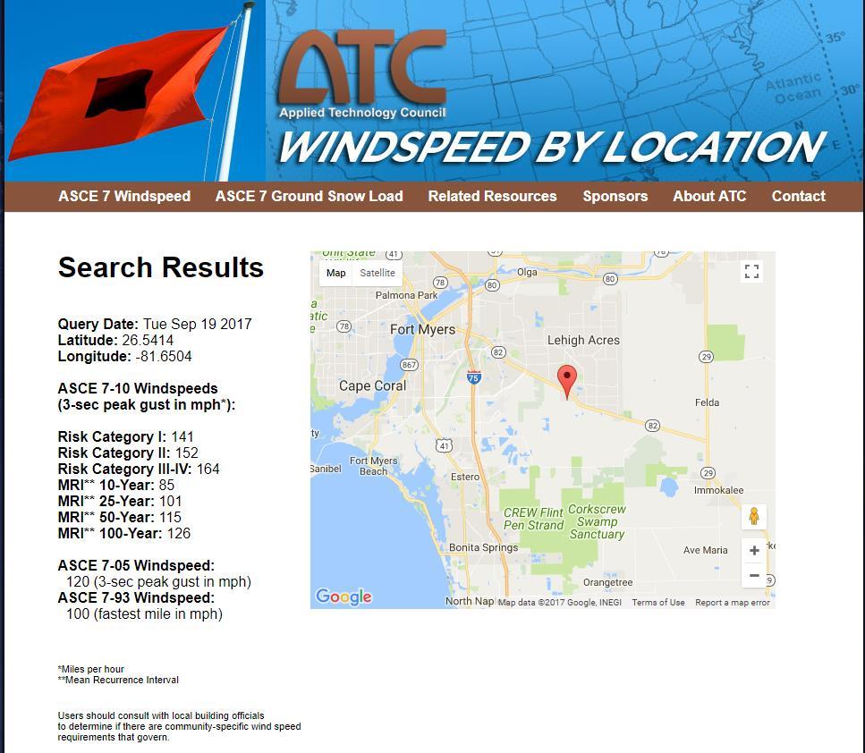
21 Translating Wind Hazard to Impacts In the absence of actual information about a given structure, the design wind speeds that the structure was built to can be used as a rough guide to formulate an expectation on how a residential structure may perform during a hurricane. The acceptable stress design wind speed (v asd ) is the 3-sec gust wind speed that has a 50 year return period (2% probability of occurring in a given year), measured in an open exposure (Category C) at 10 m height. New standards, such as the ASCE 7-16, now use what is called the ultimate design wind speed (v ultimate ) which is set by structure category. For residential construction (Risk Category II), v ultimate is determined by the 700-year return level wind speed. For purposes of estimating damage to the structure itself, and losses of the contents therein, the relevant structural performance characteristic is the breach of the building envelope (Li and Ellingwood 2009). Building components are typically rated such that they will not experience inelastic deformation or other types of failure so long as v < v asd. For wind speeds above v asd but still below v ultimate, inelastic deformations may occur (i.e., damage to the building envelope), sometimes leading to significant damage to the contents within (e.g., water damage) which could compromise the ability of occupants to remain in the home after the storm (e.g., mold). The structure should still generally maintain significant ability to protect life and safety of its occupants. As the wind speed approaches and exceeds v ultimate, significant damage becomes likely with an increasing possibility of total structural collapse.
22
23 More sophisticated approaches Another approach to estimating the wind impact is a fragility analysis on the individual building components: roofing system method by which roof is attached to walls large windows patio doors garage doors Generally, the weakest component in the building envelope represents the most significant risk to experiencing a breach of the envelope, although this depends significantly on the wind direction. If such information is available, a more accurate picture of the potential damage can be provided. Gathering the requisite information however, would likely require a structural inspection. When coupled with probabilistic wind information, fragility analysis can provide an estimated range of damage that may occur. The likelihood that the structure may lose its ability to provide life and safety protection can also be estimated.
24 Keeping the message simple The Hurricane Risk Calculator will likely display potential damage in a 3-point color categorical scale that relates to the potential safety of the structure during the storm and the habitability after the storm: Green tag condition likely (v v asd ): no significant structural damage is expected (non-structural damage possible, e.g. fences, out-buildings, etc.) Yellow tag condition is likely (v asd < v v ultimate ): some structural damage possible; some loss to contents is likely; structure may not be habitable following the storm due to water damage, mold, and/or loss of utility services Red tag condition is likely (v > v ultimate ): significant damage is possible up to a total loss of the structure and its contents. Structure could lose its ability to protect life and safety of occupants, the real-time predicted wind information can be convolved with vulnerability curves for that particular class of structures to estimate a dollar figure for the probable damage. The presence of large trees, wind-borne debris, and other factors must also be considered. The calculator will ask some basic questions of users to screen for these risks.

25 The Risk Spectrum
26 Goals of the Hurricane Risk Calculator Provide wind risk information localized by a user s address Users will enter their address, then get back wind hazard and risk information customized for their specific location, including: Their elevation (if <40 feet, flag the potential storm surge risk which would take precedence over wind risk) NDFD grid-point-forecasted winds Official NHC hurricane wind probabilities for 34-, 50-, and 64-kt winds at their location Additionally, the tool will use the terrain-adjusted Kepert-Wang boundary layer model to provide an estimate of the local wind over land that accounts for terrain Timing of onset of tropical storm-force and hurricane-force winds Provide a swath or storm footprint showing the maximum expected winds. Provide the ASCE 7-16 wind hazard information for their location to provide context Information will then be translated into understandable forms in a dashboard-like interface with graphs and text, with a goal of informing evacuation vs. shelter-inplace decisions. The initial project is funded by the RAL Opportunity Fund. The tool will be incorporated into the Tropical Cyclone Guidance Project by 2018 hurricane season.
Moving from Hazard to Risk: The Hurricane Risk Calculator
 Moving from Hazard to Risk: The Hurricane Risk Calculator Dr. Jonathan L. Vigh with thanks to Bruce Ellingwood, Cao Wang, Thomas Kloetzke WWRP Typhoon Landfall Demonstration Project Workshop 10 July 2018
2017 Hurricane Season and Beyond
 2017 Hurricane Season and Beyond Ken Graham National Hurricane Center Building a Weather-Ready Nation Much of U.S. Coast Saw Tropical Wind Watches or Warnings 2017 Hurricane Season Facts and Figures 7th
Are You Ready For Hurricane Season? 2018 Hurricane Talk B Y : S T O R M T E A M 8 M E T E O R O L O G I S T J U L I E P H I L L I P S
 Are You Ready For Hurricane Season? 2018 Hurricane Talk B Y : S T O R M T E A M 8 M E T E O R O L O G I S T J U L I E P H I L L I P S About Me I am Currently a Weekday Meteorologist at WFLA Channel 8.
2015 Hurricane Season BY: STORM TEAM 8 METEOROLOGIST JULIE PHILLIPS
 2015 Hurricane Season BY: STORM TEAM 8 METEOROLOGIST JULIE PHILLIPS FORECAST COLORADO STATE UNIVERSITY FORECAST IS CALLING FOR ONE OF THE LEAST ACTIVE SEASONS SINCE THE MID 20 TH CENTURY! THE OFFICIAL
The Wind Hazard: Messaging the Wind Threat & Corresponding Potential Impacts
 The Wind Hazard: Messaging the Wind Threat & Corresponding Potential Impacts Scott Spratt Warning Coordination Meteorologist NWS Melbourne, FL David Sharp Science & Operations Officer NWS Melbourne, FL
Planning for the Threat Preparing for the Impacts The Role of the Local Forecast
 Planning for the Threat Preparing for the Impacts The Role of the Local Forecast 2014 Florida Governor Hurricane Conference Pablo Santos NOAA/NWS WFO Miami, FL 2014 - FLGHC 2014 - FLGHC Decision Support
Hurricane Season 2018
 Hurricane Season 2018 Mission Protect LIFE and Property (Save Lives and Livelihoods) NOAA/ National Weather Service We are NOT a 9-to-5 agency. We operate 24/7/365 serving communities. We are available
Frank Revitte National Weather Service. Weather Forecast Office New Orleans/Baton Rouge
 Frank Revitte National Weather Service Weather Forecast Office New Orleans/Baton Rouge Above normal activity 17 Total Named Storms 7 Tropical Storms 4 Hurricanes 6 Major Hurricanes Not the most active,
Diagnosing the Large Swell Event Associated with the Extratropical Transition of Hurricane Florence
 Diagnosing the Large Swell Event Associated with the Extratropical Transition of Hurricane Florence Mark Willis National Hurricane Center Tropical Analysis and Forecast Branch (TAFB) Thanks to: Jack Beven,
GC Briefing. Weather Sentinel Tropical Storm Michael. Status at 8 AM EDT (12 UTC) Today (NHC) Discussion. October 11, 2018
 Today (NHC) Discussion. October 11, 2018") GC Briefing Weather Sentinel Tropical Storm Michael October 11, 2018 After making landfall as a high-end category-4 hurricane on the Florida Panhandle, Michael weakened to tropical storm status early this
GC Briefing Weather Sentinel Tropical Storm Michael October 11, 2018 After making landfall as a high-end category-4 hurricane on the Florida Panhandle, Michael weakened to tropical storm status early this
The Saffir-Simpson Hurricane Wind Scale
 The Saffir-Simpson Hurricane Wind Scale The Saffir-Simpson Hurricane Wind Scale is a one to five categorization based on the hurricane's intensity at the indicated time. The scale provides examples of
Major Hurricane Matthew Briefing Situation Overview
 Major Hurricane Matthew Briefing Situation Overview THIS IS NOW A WORST CASE STORM SURGE SCENARIO Catastrophic Damage is Anticipated for Coastal Areas. Major Hurricane Matthew is still expected to move
Hurricane Charley: A Retrospective 2014 Florida Governor s Hurricane Conference
 Hurricane Charley: A Retrospective 2014 Florida Governor s Hurricane Conference 2004 Hurricane Season: Storm Tracks Satellite Images of 2004 Hurricanes Charley Frances Ivan Jeanne Three Hurricanes in Polk
Miami-Dade County Overview
 Miami-Dade County Overview 2,000 square miles World s busiest cruise port 2.6 million residents Second busiest US airport for international travelers Gateway to the Caribbean and Latin America Natural
Careful, Cyclones Can Blow You Away!
 Title: Careful, Cyclones Can Blow You Away! (Meteorology) Grade(s): 6-8 Introduction: Most people associate twisters with tornadoes, but in fact tropical twisters come from hurricanes. Hurricanes are what
NWS HURRICANES June 3, 2015
 NWS HURRICANES June 3, 2015 Hurricane Season June 1 November 30 2 What s the concern? All tropical systems passing within 125nm of central Maryland since 1950 Mid-Atlantic Hurricanes Greatest Risk: August
Footprinting Global Tropical Cyclones
 Footprinting Global Tropical Cyclones James Done, Greg Holland and Ming Ge: NCAR, Willis Research Network Ioana Dima-West, Geoffrey Saville and Sam Phibbs: Willis Towers Watson Yuqing Wang: U. Hawaii WRN
Tropical Update. 5 AM EDT Wednesday, September 6, 2017 Hurricane Irma, Tropical Storm Jose, and Tropical Storm Katia
 Tropical Update 5 AM EDT Wednesday, September 6, 2017 Hurricane Irma, Tropical Storm Jose, and Tropical Storm Katia This update is intended for government and emergency response officials, and is provided
Hurricane Matthew Threats and Impacts Briefing for Eastern NC
 Hurricane Matthew Threats and Impacts Briefing for Eastern NC October 6 th, 2016 Date/Time Created: 10/6/2016, Noon EDT National Weather Service Newport/Morehead City, NC Hurricane Matthew Key Points Changes
The Local Wind Forecast and Its Uncertainty (Completing the Wind Forecast)
") The Local Wind Forecast and Its Uncertainty (Completing the Wind Forecast) Florida Governor Hurricane Conference May 11-16 2014 Pablo Santos Meteorologist In Charge NWS Miami/South Florida Forecast Office
The Local Wind Forecast and Its Uncertainty (Completing the Wind Forecast) Florida Governor Hurricane Conference May 11-16 2014 Pablo Santos Meteorologist In Charge NWS Miami/South Florida Forecast Office
HVX-HURREVAC (Beta) Webinar Series
 Webinar Series") HVX-HURREVAC (Beta) Webinar Series Day 1 - An introduction to HURREVAC and the new web-based HVX platform 2018 HVX-HURREVAC Webinar Series 1. Intro to HURREVAC and General Overview of the Program (August
HVX-HURREVAC (Beta) Webinar Series Day 1 - An introduction to HURREVAC and the new web-based HVX platform 2018 HVX-HURREVAC Webinar Series 1. Intro to HURREVAC and General Overview of the Program (August
Comparative Analysis of Hurricane Vulnerability in New Orleans and Baton Rouge. Dr. Marc Levitan LSU Hurricane Center. April 2003
 Comparative Analysis of Hurricane Vulnerability in New Orleans and Baton Rouge Dr. Marc Levitan LSU Hurricane Center April 2003 In order to compare hurricane vulnerability of facilities located in different
GC Briefing. Weather Sentinel Hurricane Florence. Status at 5 PM EDT (21 UTC) Today (NHC) Discussion. September 13, 2018
 Today (NHC) Discussion. September 13, 2018") GC Briefing September 13, 2018 Weather Sentinel Hurricane Florence Tropical storm conditions have been reported for areas of North Carolina and will continue to spread inland to the west and south. Hurricane
GC Briefing September 13, 2018 Weather Sentinel Hurricane Florence Tropical storm conditions have been reported for areas of North Carolina and will continue to spread inland to the west and south. Hurricane
2008 Hurricane Caravan. Daniel Noah Meteorologist National Weather Service x1 May 22, 2008
 2008 Hurricane Caravan Daniel Noah Meteorologist National Weather Service daniel.noah@noaa.gov, 813-645-2323 x1 May 22, 2008 National Weather Service We never close! Open 24 hours a day 365 days per year
Probabilistic Hurricane Storm Surge A Local Perspective
 Probabilistic Hurricane Storm Surge A Local Perspective Florida Governor Hurricane Conference May 11-16 2014 2014 FLGHC TS 22 Pablo Santos Meteorologist In Charge NWS Miami/South Florida Forecast Office
Tropical Update. 5 PM EDT Thursday, September 7, 2017 Hurricane Irma, Hurricane Jose, and Hurricane Katia
 Tropical Update 5 PM EDT Thursday, September 7, 2017 Hurricane Irma, Hurricane Jose, and Hurricane Katia This update is intended for government and emergency response officials, and is provided for informational
Daily Operations Briefing. Sunday, September 24, :30 a.m. EDT
 Daily Operations Briefing Sunday, September 24, 2017 8:30 a.m. EDT Significant Activity Sep 23-24 Significant Events: Response for Hurricane Maria Tropical Activity: Atlantic Hurricane Maria (CAT 2); Hurricane
Daily Operations Briefing. Monday, October 9, :30 a.m. EDT
 Daily Operations Briefing Monday, October 9, 2017 8:30 a.m. EDT Significant Activity Oct 8-9 Significant Events: Response for Hurricane Maria Tropical Activity: Atlantic Tropical Depression Seventeen Eastern
Tropical Update. 5 AM EDT Thursday, September 7, 2017 Hurricane Irma, Hurricane Jose, and Hurricane Katia
 Tropical Update 5 AM EDT Thursday, September 7, 2017 Hurricane Irma, Hurricane Jose, and Hurricane Katia This update is intended for government and emergency response officials, and is provided for informational
Hurricane Matthew. National Weather Service Wilmington NC. Steven Pfaff, WCM.
 Hurricane Matthew Threat Assessment for northeast South Carolina & southeast North Carolina National Weather Service Wilmington NC 730 AM EDT Tuesday October 4, 2016 Steven Pfaff, WCM Steven.Pfaff@noaa.gov
Daily Operations Briefing. Thursday, September 21, :30 a.m. EDT
 Daily Operations Briefing Thursday, September 21, 2017 8:30 a.m. EDT Significant Activity Sep 20-21 Significant Events: Response for Hurricane Maria Tropical Activity: Atlantic Tropical Storm Jose; Hurricane
10 years after Hurricane Charley
 10 years after Hurricane Charley Hurricane Charley (2004) A Retrospective Scott M. Spratt Warning Coordination Meteorologist NWS Melbourne, FL Florida Governors Hurricane Conference May 15, 2014 11 AM
Daily Operations Briefing. Wednesday, September 27, :30 a.m. EDT
 Daily Operations Briefing Wednesday, September 27, 2017 8:30 a.m. EDT Significant Activity Sep 26-27 Significant Events: Response for Hurricane Maria Tropical Activity: Atlantic Tropical Storm Maria; Hurricane
Betty Hearn Morrow Consulting Sociologist Professor Emerita, Florida International University
 Betty Hearn Morrow Consulting Sociologist Professor Emerita, Florida International University 2018 WMO RA-IV Workshop on Hurricane Forecasting and Warning National Hurricane Center - Miami, Florida 8 March
Tropical Update. 12 PM EDT Friday, October 7, 2016 Hurricane Matthew & Tropical Storm Nicole
 Tropical Update 12 PM EDT Friday, October 7, 2016 Hurricane Matthew & Tropical Storm Nicole This update is intended for government and emergency response officials, and is provided for informational and
Hurricane Recipe. Hurricanes
 Hurricanes A hurricane is a powerful, rotating storm that forms over warm oceans near the Equator. Hurricanes have strong, rotating winds (at least 74 miles per hour), a huge amount of rain, low air pressure,
National Situation Report As of 3:00 a.m. EDT, Thursday, September 21, 2017 Table of Contents Current Operations Monitoring Recovery
 25k Overview National Situation Report As of 3:00 a.m. EDT, Thursday, September 21, 2017 Table of Contents Current Operations Monitoring Recovery FEMA Headquarters Status FEMA Region Status NRCC Level
Natural Disasters PASSAGE 5
 PASSAGE 5 Name Directions: Read Natural Disasters. Then answer questions 1 8. Natural Disasters Our planet can be a calm place, but weather conditions often change rapidly. Gentle breezes can blow into
PUBLIC SAFETY POWER SHUTOFF POLICIES AND PROCEDURES
 PACIFIC GAS AND ELECTRIC COMPANY PUBLIC SAFETY POWER SHUTOFF POLICIES AND PROCEDURES SEPTEMBER 2018 1 PACIFIC GAS AND ELECTRIC COMPANY PUBLIC SAFETY POWER SHUTOFF POLICIES AND PROCEDURES SEPTEMBER 2018
Hurricane Readiness for Coastal Communities
 Hurricane Readiness for Participant Guide Developed for: Federal Emergency Management Agency Emergency Management Institute 16825 South Seton Avenue Emmitsburg, MD 21727-8998 Developed by: C² Technologies,
A HURRICANE IS COMING. Presented by Atiba Upchurch Broward Emergency Management Division
 A HURRICANE IS COMING Presented by Atiba Upchurch Broward Emergency Management Division Mission Statement To safeguard the lives and property of the people of Broward County from major hazards and emergencies
Name Earth Science Pd. Hurricanes. Directions: Read the information, view diagrams and answer the questions in the worksheet.
 Hurricanes Directions: Read the information, view diagrams and answer the questions in the worksheet. Hurricane Basics The ingredients for a hurricane include a pre-existing weather disturbance, warm tropical
Donna J. Kain, PhD and Catherine F. Smith, PhD East Carolina University
 Risk Perceptions and Emergency Communication Effectiveness in Coastal Zones Preliminary Findings on Interpretations of Weather Related Messages and Maps Donna J. Kain, PhD (kaind@ecu.edu), and Catherine
Hurricane Shelter Standards Governors Hurricane Conference 2018
 Hurricane Shelter Standards Governors Hurricane Conference 2018 Partnership with Florida Local Level State Level Hurricane Evacuation Studies Hurricane Evacuation Study Fresh Water Flooding Storm Surge
Natural Disasters. in Florida. Severe Thunderstorms
 Natural Disasters in Florida SC.6.E.7.7 Investigate how natural disasters have affected human life in Florida. Severe Thunderstorms While the typical afternoon thunderstorm in Florida may not appear to
Hurricanes. Cause: a low pressure storm system over warm ocean water. Effect: potential massive widespread destruction and flooding.
 Hurricanes Hurricanes Cause: a low pressure storm system over warm ocean water. Effect: potential massive widespread destruction and flooding. Hurricanes also known as: cyclone (Indian Ocean) or typhoon
RSMC-Miami Update Daniel Brown Warning Coordination Meteorologist
 RSMC-Miami Update 2016 Daniel Brown Warning Coordination Meteorologist L-0324 Emergency Management Hurricane Preparedness Training Course Funding provided by FEMA s National Hurricane Program - partnership
HURRICANES. Source:
 HURRICANES Source: http://www.dc.peachnet.edu/~pgore/students/w97/matheson/hpage.htm What is a hurricane? Violent cyclonic storm that develops in the tropical region Wind speeds are > 74 mph Source: http://www.google.com/imgres?hl=en&sa=x&biw=1920&bih=955&tbm=
Hazard Warnings and Warning Systems
 Hazard Warnings and Warning Systems Lecture Objectives: -Know the main features and limitations of our national warning system -learn the key features of an effective warning system Sorensen, J.H. (2000)
Chapter 16, Part Hurricane Paths. 2. Hurricane Paths. Hurricane Paths and Damage
 Chapter 16, Part 2 Hurricane Paths and Damage 1. Hurricane Paths Start over tropical water except South Atlantic and eastern South Atlantic, where water is too cold. Initially steered by easterly winds
LECTURE #18: Hurricane Damage, Monitoring & Case Study
 GEOL 0820 Ramsey Natural Disasters Spring, 2018 LECTURE #18: Hurricane Damage, Monitoring & Case Study Date: 27 March 2018 I. Exam II grades now posted online o high: 98, low: 46, average: 80 (~3 points
NOAA Storm Surge Modeling Gaps and Priorities
 NOAA Storm Surge Modeling Gaps and Priorities HFIP Meeting November 9 th, 2017 Laura Paulik Alaka NHC Storm Surge Unit Introduction to Probabilistic Storm Surge P-Surge is based on an ensemble of Sea,
Tropical Update. 5 PM EDT Thursday, August 27, 2015 Tropical Storm Erika
 Tropical Update 5 PM EDT Thursday, August 27, 2015 Tropical Storm Erika This update is intended for government and emergency response officials, and is provided for informational and situational awareness
Hazardous Weather and Flooding Preparedness. Hazardous Weather and Flooding Preparedness
 Hazardous Weather and Flooding Preparedness 1 A Cooperative Effort 2 Administrative Information Emergency exits and procedures Location of restrooms Mobile devices Procedure for questions Course materials
Tropical Update 6 AM EDT Friday, October 7, 2016 Hurricane Matthew & Hurricane Nicole
 Tropical Update 6 AM EDT Friday, October 7, 2016 Hurricane Matthew & Hurricane Nicole This update is intended for government and emergency response officials, and is provided for informational and situational
HURRICANE IRMA. 12 PM ET Saturday, September Prepared by: Kyle Thiem / Sid King.
 HURRICANE IRMA 12 PM ET Saturday, September 9 2017 Prepared by: Kyle Thiem / Sid King www.weather.gov/atlanta/briefings @NWSAtlanta www.weather.gov/atlanta Situation Overview 11:00 AM EDT Sat Sep 9 Location:
#FakeWeather, Cape Fear Hurricanes, and the 2018 Hurricane Season Outlook. Building a Weather-Ready Nation
 #FakeWeather, Cape Fear Hurricanes, and the 2018 Hurricane Season Outlook The #FakeWeather Epidemic #FakeWeather Expect it Before, During, & After an Event Before an event the spread of highly uncertain
Where Do Hurricanes Occur?
 Where Do Hurricanes Occur? How Often Do Hurricanes Hit the U.S.? Hurricane Return Periods Hurricane return periods are the frequency at which a certain intensity of hurricane can be expected within a
Hurricane Florence: Rain this heavy comes along once every 1,000 years
 Hurricane Florence: Rain this heavy comes along once every 1,000 years By Associated Press, adapted by Newsela staff on 09.17.18 Word Count 786 Level 810L Image 1. This satellite image provided by the
Daily Operations Briefing. Tuesday, October 24, :30 a.m. EDT
 Daily Operations Briefing Tuesday, October 24, 2017 8:30 a.m. EDT Significant Activity Oct 23-24 Significant Events: Response and recovery Tropical Cyclones Harvey, Irma, Maria Tropical Activity: Atlantic
Enhancing Weather Information with Probability Forecasts. An Information Statement of the American Meteorological Society
 Enhancing Weather Information with Probability Forecasts An Information Statement of the American Meteorological Society (Adopted by AMS Council on 12 May 2008) Bull. Amer. Meteor. Soc., 89 Summary This
photo courtesy of
 BRITISH VIRGIN ISLANDS REPORT TROPICAL STORM JEANNE photo courtesy of www.bviplatinum.com PREPARED BY THE DEPARTMENT OF DISASTER MANAGEMENT 1 EVENT 13 th -16 th September, 2004 TROPICAL STORM JEANNE Sequence
KCC White Paper: The 100 Year Hurricane. Could it happen this year? Are insurers prepared? KAREN CLARK & COMPANY. June 2014
 KAREN CLARK & COMPANY KCC White Paper: The 100 Year Hurricane Could it happen this year? Are insurers prepared? June 2014 Copyright 2014 Karen Clark & Company The 100 Year Hurricane Page 1 2 COPLEY PLACE
Scenario-based Language for Hurricane Decision Support
 Scenario-based Language for Hurricane Decision Support David Sharp NOAA/National Weather Service Melbourne, FL Pablo Santos NOAA/National Weather Service Miami, FL Weather Model Outcomes (as seen on TV)
Wind Tower Deployments and Pressure Sensor Installation on Coastal Houses Preliminary Data Summary _ Sea Grant Project No.
 Wind Tower Deployments and Pressure Sensor Installation on Coastal Houses Preliminary Data Summary _ Sea Grant Project No.:1020040317 Submitted to: South Carolina Sea Grant Consortium 287 Meeting Street
Tropical Storm Ana. Created 6:00 AM Sun May 10, 2015 John Cole Warning Coordination Meteorologist
 Tropical Storm Ana Threat Assessment for Eastern North Carolina Created 6:00 AM Sun May 10, 2015 John Cole Warning Coordination Meteorologist John.cole@noaa.gov National Weather Service Newport/Morehead
Hurricanes and coastal storms pose a risk because powerful winds and storm surges can:
 HURRICANES A hurricane is a violent area of low pressure forming in the tropical Atlantic Ocean from June to November. August and September are peak months. (Similar Western Pacific Ocean storms are called
Wind Speed Probability Products
 Wind Speed Probability Products Daniel Brown National Hurricane Center 2018 WMO Course 6 March 2018 Wind Speed Probabilities A Tool to Deal with Uncertainty Hurricane Irene Advisory Number 12 Issued 5:00
WEATHER SYSTEMS IMPACTING THE CAYMAN ISLANDS Prepared by the staff of the Cayman Islands National Weather Service
 WEATHER SYSTEMS IMPACTING THE CAYMAN ISLANDS 2008 Prepared by the staff of the Cayman Islands National Weather Service TROPICAL STORM DOLLY Formed 194 miles west of Grand Cayman July 19 th. The tropical
2006 & 2007 Pre-Hurricane Scenario Analyses
 2006 & 2007 Pre-Hurricane Scenario Analyses Executive Summary May 2007 Page 1 OF X FOR OFFICIAL USE ONLY 4 Public Availability to be Determined Under 5 U.S.C. 552 NOTE: Limited Distribution. Release of
Hurricane Tracking Lab
 Hurricane Tracking Lab Background: Hurricanes are one of nature s most powerful disasters. To equal the power of a hurricane, one would have to set off about a thousand nuclear devices per second for as
CURRENT AND FUTURE TROPICAL CYCLONE RISK IN THE SOUTH PACIFIC
 CURRENT AND FUTURE TROPICAL CYCLONE RISK IN THE SOUTH PACIFIC COUNTRY RISK PROFILE: SAMOA JUNE 2013 Samoa has been affected by devastating cyclones on multiple occasions, e.g. tropical cyclones Ofa and
The Wind Speeds in Selected Islands During Hurricanes Irma and Maria in 2017 compiled by Tony Gibbs FREng
 The Wind Speeds in Selected Islands During Hurricanes Irma and Maria in 2017 compiled by Tony Gibbs FREng Structural failures leading to serious damage or collapse, or those severely affecting the use
Tropical Update. 5 PM EDT Tuesday, September 5, 2017 Hurricane Irma, Tropical Storm Jose, and Tropical Depression Thirteen
 Tropical Update 5 PM EDT Tuesday, September 5, 2017 Hurricane Irma, Tropical Storm Jose, and Tropical Depression Thirteen This update is intended for government and emergency response officials, and is
Storm Surge Forecast with Shifting Forecast Tracks
 Storm Surge Forecast with Shifting Forecast Tracks Storm Surge Findings in the Florida Keys Jon Rizzo Warning Coordination Meteorologist National Weather Service Florida Keys Florida Keys Life History
Lessons Learned from Hurricane Harvey and Irma
 EOL Visit to NSF 3 March 2016 Lessons Learned from Hurricane Harvey and Irma Wen-Chau Lee National Center for Atmospheric Research 23 November 2017 Outline: Meteorological elements of the active 2017 Atlantic
 Hazard Warnings GE 4150 Natural Hazards September 17, 2007 http://www.sdr.gov/ndis_rev_oct27.pdf Sorensen, J.H. (2000) Hazard warning systems: Review of 20 years of progress. Natural Hazards Review, May,
James M. Shultz MS PhD 1 Zelde Espinel MD MA MPH 2 Andreas Rechkemmer MA Dr rer pol 3
 National Academy of Sciences: Data matters: ethics, data, and international research collaboration in a changing world Domain-specific examples: Disasters James M. Shultz MS PhD 1 Zelde Espinel MD MA MPH
HURRICANE SURVIVAL KIT
 HURRICANE SURVIVAL KIT DEFINITION-A hurricane is a very vast and powerful storm that originates in the tropics of the Atlantic Ocean. They become hurricanes when the sustained winds associated with it
HURREVAC The software Tool used by emergency officials for hurricane evacuation assistance
 HURREVAC 2010 A Quick Reference enc e Guide The software Tool used by emergency officials for hurricane evacuation assistance www.hurrevac.com FinalHURREVAC2010Guide.indd 1 About HURREVAC HURREVAC is a
Tropical Cyclone Hazards. Presentation
 Tropical Cyclone Hazards Presentation Kerry N Mallory AE5JY September 7, 2011 Tropical Cyclone Hazards The Four Primary Weapons of a Tropical Cyclone are: 1. Wind 2. Storm Surge 3. Rain/Freshwater Flooding
HURRICANES IRMA AND MARIA
 EXECUTIVE SUMMARY HURRICANES IRMA AND MARIA Bloomberg Philanthropies USVI Hurricane Recovery and Resilience Task Force 1 Hurricanes Irma and Maria, both Category 5 storms with wind gusts of up to 178 MPH
Tropical Update. 5 PM EDT Sunday, September 10, 2017 Hurricane Irma, Hurricane Jose, Tropical Wave (60%)
") Tropical Update 5 PM EDT Sunday, September 10, 2017 Hurricane Irma, Hurricane Jose, Tropical Wave (60%) This update is intended for government and emergency response officials, and is provided for informational
Tropical Update 5 PM EDT Sunday, September 10, 2017 Hurricane Irma, Hurricane Jose, Tropical Wave (60%) This update is intended for government and emergency response officials, and is provided for informational
Coastal Resiliency: Planning for Natural Variability and Recovering from Extreme Events
 Coastal Resiliency: Planning for Natural Variability and Recovering from Extreme Events Stephanie Showalter, J.D., M.S.E.L. Director, National Sea Grant Law Center University of Mississippi Coastal Hazards
Advisory #35 Briefing 630 PM EDT Thursday October 06, 2016
 Advisory #35 Briefing 630 PM EDT Thursday October 06, 2016 Disclaimer: The information contained within this briefing is time-sensitive, do not use beyond 6 hours after the issuance Next Webinar Update:
HURRICANE CHARLEY CHARACTERISTICS and STORM TIDE EVALUATION
 HURRICANE CHARLEY CHARACTERISTICS and STORM TIDE EVALUATION By Robert Wang, Michael Manausa And Jenny Cheng Sponsored by Florida Department of Environmental Protection, Bureau of Beaches and Coastal Systems
Tropical Update. 5 AM EDT Tuesday, September 12, 2017 Post-Tropical Cyclone Irma, Hurricane Jose, & Tropical Wave (10%)
") Tropical Update 5 AM EDT Tuesday, September 12, 2017 Post-Tropical Cyclone Irma, Hurricane Jose, & Tropical Wave (10%) This update is intended for government and emergency response officials, and is provided
Tropical Update 5 AM EDT Tuesday, September 12, 2017 Post-Tropical Cyclone Irma, Hurricane Jose, & Tropical Wave (10%) This update is intended for government and emergency response officials, and is provided
Daily Operations Briefing. Sunday, October 22, :30 a.m. EDT
 Daily Operations Briefing Sunday, October 22, 2017 8:30 a.m. EDT Significant Activity Oct 21-22 Significant Events: Response and recovery Harvey, Irma, Maria; CA Wildfires Tropical Activity: Atlantic No
1.2 DEVELOPMENT OF THE NWS PROBABILISTIC EXTRA-TROPICAL STORM SURGE MODEL AND POST PROCESSING METHODOLOGY
 1.2 DEVELOPMENT OF THE NWS PROBABILISTIC EXTRA-TROPICAL STORM SURGE MODEL AND POST PROCESSING METHODOLOGY Huiqing Liu 1 and Arthur Taylor 2* 1. Ace Info Solutions, Reston, VA 2. NOAA / NWS / Science and
Earth Science Hurricanes
 Earth Science - Hurricanes Earth Science Hurricanes Hurricanes are tropical 1 storms that start in the ocean waters near the equator. 2 The storm moves its way north where the air is cooler. The wind gets
Wind Speed Probability Products. Daniel Brown and Michael Brennan National Hurricane Center
 Wind Speed Probability Products Daniel Brown and Michael Brennan National Hurricane Center 2017 WMO Course 7 March 2017 Wind Speed Probabilities A Tool to Deal with Uncertainty Hurricane Irene Advisory
Hurricane Preparedness and Awareness!
 Hurricane Preparedness and Awareness! Check these out Time to begin executing the evacuation plan What kind of damage are we talking about here? What Exactly Is a Hurricane? A hurricane can best be described
Overview of the Tropical Cyclone Guidance Project
 Overview of the Tropical Cyclone Guidance Project Dr. Jonathan L. Vigh With thanks to Mahsa Mirzargar (Univ. of Miami) Shanghai Typhoon Institute 09 July 2018 NCAR is sponsored by the National Science
WELCOME TO THE 2018 RA-IV WORKSHOP ON HURRICANE FORECASTING AND WARNING
 WELCOME TO THE 2018 RA-IV WORKSHOP ON HURRICANE FORECASTING AND WARNING Richard J. Pasch and Daniel P. Brown Senior Hurricane Specialists National Hurricane Center ORIENTATION Use of PCs NHC Facility Workshop
Storm Summary for Hurricane Joaquin
 Storm Summary for Hurricane Joaquin Wednesday, September 30, 2015 at 5 PM EDT (Output from Hurrevac, based on National Hurricane Center Forecast Advisory #12) Joaquin is currently a Category 1 hurricane
COMMUNITY EMERGENCY RESPONSE TEAM TORNADOES
 Tornadoes are powerful, circular windstorms that may be accompanied by winds in excess of 200 miles per hour. Tornadoes typically develop during severe thunderstorms and may range in width from several
Analysis of fatalities attributed to Hurricane Florence in the US.
 Analysis of fatalities attributed to Hurricane Florence in the US. Jonathan van Leeuwen Hurricane Florence impacted the US East Coast in September 2018 resulting in dangerous surf conditions, strong winds,
Communications and Lessons Learned from
 Weather Forecast Office Charleston, SC Communications and Lessons Learned from Southeast and Caribbean and Climate Community of Practice - April, 2017 Public Information and Communications During Extremes
HURREVAC Webinar Series Day 1 Intro to HURREVAC and General Overview of the Program. National Hurricane Program Training Course
 HURREVAC Webinar Series Day 1 Intro to HURREVAC and General Overview of the Program 2017 HURREVAC Webinar Series 1. Intro to HURREVAC and General Overview of the Program (August 7 th or 14 th ) 2. Evacuation
HURRICANE IRENE. CONFERENCE CALL BRIEFING SLIDES Saturday August 27, :30 AM
 HURRICANE IRENE CONFERENCE CALL BRIEFING SLIDES Saturday August 27, 2011 8:30 AM NHC TRACK AND CONE HURRICANE IRENE WATCHES/WARNINGS Hurricane Warning along south coast including all of Cape Cod and Islands