Footprinting Global Tropical Cyclones
|
|
|
- Ella Boone
- 6 years ago
- Views:
Transcription


1 Footprinting Global Tropical Cyclones James Done, Greg Holland and Ming Ge: NCAR, Willis Research Network Ioana Dima-West, Geoffrey Saville and Sam Phibbs: Willis Towers Watson Yuqing Wang: U. Hawaii WRN Autumn Seminar Nov 1 st 2017
 Major hurricanes: 6 (2.")
2 The 2017 Hurricane Season Named storms: 16 (12.1) Hurricanes: 10 (6.4) Major hurricanes: 6 (2.7) Harvey Irma Maria Easterly Wave Developments WRN Autumn Seminar Nov 1 st 2017
3 Records Smashed September: Named-Storm Days (2004) Hurricane Days (2006) (Phil Klotzbach, CSU) Major Hurricane Days (1961) ACE (1928) Harvey: Irma: 1.54m of rain 185mph for 37 hours. Phil Klotzbach (CSU) Three cat 4+ U.S. landfalls. WRN Autumn Seminar Nov 1 st 2017

4 A Hurricane Drought? Harvey was the first major hurricane U.S. landfall since Wilma (2005). Why the drought? - physical? - luck? - definitional? storms Emphasis on count of storms above wind speed threshold is misplaced. WRN Autumn Seminar Nov 1 st 2017
5 Warm Oceans Phil Klotzbach (CSU) WRN Autumn Seminar Nov 1 st 2017
6 Warm Oceans Promotes Rapid Intensification: Harvey and Jose: Cat 1 to Cat 4 in 24 hours Maria: Cat 1 to Cat 5 in 15 hours WRN Autumn Seminar Nov 1 st 2017 Phil Klotzbach (CSU)
7 Light Winds Phil Klotzbach (CSU) WRN Autumn Seminar Nov 1 st 2017


8 Slow-Moving Harvey Rapid coastal strengthening to category 4. Track guidance fell away. Perfect set-up for record rains over Houston. WRN Autumn Seminar Nov 1 st 2017


9 Intense Irma 10-day warning of a strong hurricane in the U.S. Southeast. Repeated eye-wall cycles kept winds below 200mph. Uncertain right turn. Best possible route to minimize damage. WRN Autumn Seminar Nov 1 st 2017

10 Pinhole Maria Pinhole eye, 10 miles across. Eye-wall cycle prevented a category 5 landfall on PR. Second strongest behind San Felipe II (1928). WRN Autumn Seminar Nov 1 st 2017

11 Fast-Moving Nate Crossed Gulf of Mexico in 24 hours. Warm waters, loop current. Landfalling depression or Category 3? WRN Autumn Seminar Nov 1 st 2017
12 200 Historical Global Footprints WRN Autumn Seminar Nov 1 st
13 Current Footprinting Approaches Parametric radial wind profiles: - fast, simple terrain, landuse, inland decay factors. WRN Autumn Seminar Nov 1 st
14 Current Footprinting Approaches Parametric radial wind profiles: - fast, simple terrain, landuse, inland decay factors. Spatial analysis of observations: - asymmetries, but few storms, globally inconsistent. WRN Autumn Seminar Nov 1 st
15 Current Footprinting Approaches Parametric radial wind profiles: - fast, simple terrain, landuse, inland decay factors. Spatial analysis of observations: - asymmetries, but few storms, globally inconsistent. Geostatistical spatial modeling: - fast, only applied to European windstorm so far. WRN Autumn Seminar Nov 1 st


16 Current Footprinting Approaches Parametric radial wind profiles: - fast, simple terrain, landuse, inland decay factors. Spatial analysis of observations: - asymmetries, but few storms, globally inconsistent. Geostatistical spatial modeling: - fast, only applied to European windstorm so far. Numerical modeling: - many physical processes, but slow, track error. WRN Autumn Seminar Nov 1 st
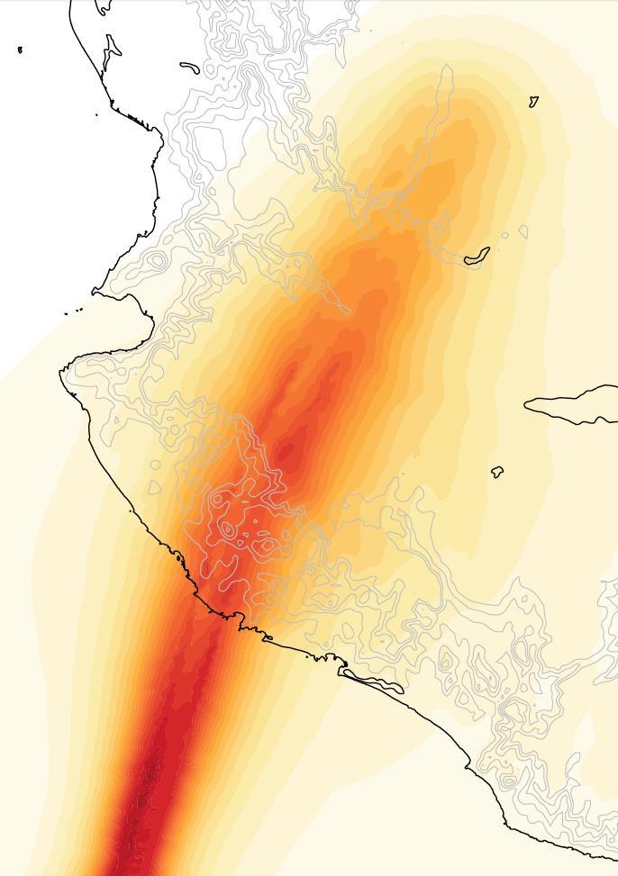
17 Topographic Speed-Up A factor proportional to terrain height and shape. Can reach 2. (Miller et al. 2012) WRN Autumn Seminar Nov 1 st


18 Channel Effects Winds parallel to mountains. Winds between mountains. WRN Autumn Seminar Nov 1 st

 WRN Autumn Seminar Nov 1")
19 Terrain drives damage Damaged roof locations in hurricane Fabian (2003). Miller et al. (2012) WRN Autumn Seminar Nov 1 st
 parametric pressure profile Kepert and Wang (2001) numerical boundary")

20 Footprinting Approach Historical track data (EBTrACS and JTWC) Holland et al. (2010) parametric pressure profile Kepert and Wang (2001) numerical boundary layer model. Fast, topographic and roughness effects, no track error, but some missing processes (e.g., strong thermal effects). WRN Autumn Seminar Nov 1 st
21 The KW01 Model Diagnoses boundary-layer flow using dry equations of motion for a given pressure field. High-order turbulence scheme - prognostic TKE, turbulence dissipation. - diagnostic length scale (<80m). Ignores strong thermal effects. Rapidly achieves steady state. 22 WRN Autumn Seminar Nov 1 st 2017
22 Mods to KW01 1. Allow storms to move: - add environment pressure gradient to TC forcing, - add storm translation velocity to horizontal advection. 23 WRN Autumn Seminar Nov 1 st 2017
23 Mods to KW01 1. Allow storms to move: - add environment pressure gradient to TC forcing, - add storm translation velocity to horizontal advection. 2. Allow storms to change intensity and size: - update pressure gradient and allow winds to respond, - force gradient winds at model top. 24 WRN Autumn Seminar Nov 1 st 2017
24 Mods to KW01 1. Allow storms to move: - add environment pressure gradient to TC forcing, - add storm translation velocity to horizontal advection. 2. Allow storms to change intensity and size: - update pressure gradient and allow winds to respond, - force gradient winds at model top. 3. Include some topographic effects: - included in model equations. 4. Include variable surface roughness effects: - drag coefficient = f(terrain height and landuse). 25 WRN Autumn Seminar Nov 1 st 2017
25 Effects of Complex Topography Hurricane Maria (2017) ms -1 WRN Autumn Seminar Nov 1 st
 ms -1 WRN Autumn Seminar Nov 1 st 2017")
26 Variable Surface Roughness Hurricane Wilma (2005) ms -1 WRN Autumn Seminar Nov 1 st
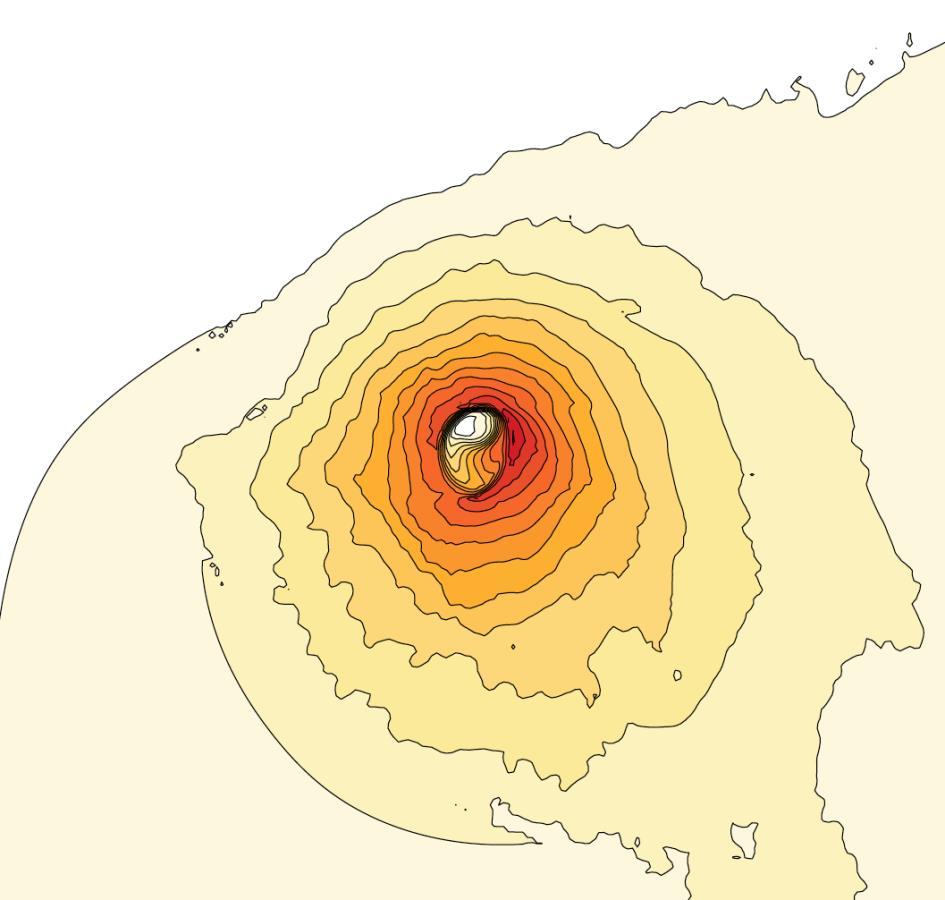
27 Eye-Wall Asymmetries? Hurricane Patricia (2015) WRN Autumn Seminar Nov 1 st

28 Good comparison with HWIND Hurricane Wilma (2005) WRN HWIND ms -1 Similar asymmetry. Similar wind speed reduction at the coast. WRN Autumn Seminar Nov 1 st
29 Surface Station Comparisons Hurricane Maria (2017) ms -1 WRN Autumn Seminar Nov 1 st

30 Hurricane Harvey ms -1 ms -1 ms -1 WRN Autumn Seminar Nov 1 st
31 Hurricane Harvey WRN Autumn Seminar Nov 1 st

32 Hurricane Irma ms -1 ms -1 WRN Autumn Seminar Nov 1 st


33 Reconstructing older events Typhoon Ellen (1983): Data: V max, lat, lon: IBTrACS. R max : Hong Kong radar. Constant 35km. R 34 : Hong Kong barogram. Set to 150km at landfall, then decrease following wind decay WRN Autumn Seminar Nov 1 st

34 Ellen s Footprint at 78m Unique view of risk to high rise structures. ms -1 WRN Autumn Seminar Nov 1 st

35 Application to Hazard Risk Combining with TC risk modeling to produce new views of global wind risk. Particularly valuable in regions of complex terrain. 10% annual wind speed (ms -1 ) WRN Autumn Seminar Nov 1 st
36 Summary A globally-consistent topography-aware historical footprint dataset. New views of historical events. Dataset version 1.0. WRN Autumn Seminar Nov 1 st
LECTURE #18: Hurricane Damage, Monitoring & Case Study
 GEOL 0820 Ramsey Natural Disasters Spring, 2018 LECTURE #18: Hurricane Damage, Monitoring & Case Study Date: 27 March 2018 I. Exam II grades now posted online o high: 98, low: 46, average: 80 (~3 points
Inner core dynamics: Eyewall Replacement and hot towers
 Inner core dynamics: Eyewall Replacement and hot towers FIU Undergraduate Hurricane Internship Lecture 4 8/13/2012 Why inner core dynamics is important? Current TC intensity and structure forecasts contain
11/17/2017. Memorable Hurricanes of 2004 MET 4532
 MET 4532 2004 Hurricane Season Lecture 31 & 32 2004, 2005, and After 17-20 November 2017 1 2 Memorable Hurricanes of 2004 Hurricane Dates Damage (US) Deaths (US) Charlie (4) 9-14 AUG $14B 10 Ivan (4) 2-24
and Weather extremes Tropical cyclones Today and in the Future Greg Holland c3we.ucar.edu
 Tropical cyclones and Weather extremes Today and in the Future c3we.ucar.edu Greg Holland (gholland@ucar.edu) Supported by NSF, Willis Re, IAG, and Zurich Insurance 1 Topics State of the Climate and its
Lessons Learned from Hurricane Harvey and Irma
 EOL Visit to NSF 3 March 2016 Lessons Learned from Hurricane Harvey and Irma Wen-Chau Lee National Center for Atmospheric Research 23 November 2017 Outline: Meteorological elements of the active 2017 Atlantic
LECTURE #17: Severe Weather: Introduction to Hurricanes
 GEOL 0820 Ramsey Natural Disasters Spring, 2018 LECTURE #17: Severe Weather: Introduction to Hurricanes Date: 15 March 2018 I. Hurricane Overview hurricanes o what they are? o how they form? storm stages:
Lecture 18 Hurricanes
 Lecture 18 Hurricanes Part I Structure and Climatology What is a hurricane? What is the structure or anatomy of a hurricane? How to build a hurricane - hurricane energy Hurricane climatology - when and
A Hurricane Outlook for the 21st Century.
 A Hurricane Outlook for the 21st Century. Hugh Willoughby Florida International University Cat Winds Effects One 74-95 mph No real damage to building structures. Two Three Four Five 96-110 mph 111-130
H.3 Severe Impacts of Hurricane Irma in Cuba: Forecast Models, Forecast and Warning Processes.
 H.3 Severe Impacts of Hurricane Irma in Cuba: Forecast Models, Forecast and Warning Processes. Jose Rubiera Institute of Meteorology, La Habana, Cubauba Special Session: Recent high-impact landfalling
The 2014 Atlantic Hurricane Season. What is New and What to Expect. Mark Chambers President & CEO ImpactWeather, Inc.
 The 2014 Atlantic Hurricane Season What is New and What to Expect Mark Chambers President & CEO ImpactWeather, Inc. Hurricane Climatology for the Gulf of Mexico A Look back at 2013 The outlook for this
Comparative Analysis of Hurricane Vulnerability in New Orleans and Baton Rouge. Dr. Marc Levitan LSU Hurricane Center. April 2003
 Comparative Analysis of Hurricane Vulnerability in New Orleans and Baton Rouge Dr. Marc Levitan LSU Hurricane Center April 2003 In order to compare hurricane vulnerability of facilities located in different
Unit 5 Part 2 Test PPT
 Unit 5 Part 2 Test PPT Standard 1: Air Masses Air Mass An air mass is an immense body of air that is characterized by similar temperatures and amounts of moisture at any given altitude When an air mass
Tropical Cyclone Megh
 Tropical Cyclone Megh 4-10 November 2015 NE Somalia and S Yemen Desert Locust Information Service FAO, Rome www.fao.org/ag/locusts Keith Cressman (Senior Locust Forecasting Officer) 04/11/2015 Tropical
Are You Ready For Hurricane Season? 2018 Hurricane Talk B Y : S T O R M T E A M 8 M E T E O R O L O G I S T J U L I E P H I L L I P S
 Are You Ready For Hurricane Season? 2018 Hurricane Talk B Y : S T O R M T E A M 8 M E T E O R O L O G I S T J U L I E P H I L L I P S About Me I am Currently a Weekday Meteorologist at WFLA Channel 8.
HURRICANES. Source:
 HURRICANES Source: http://www.dc.peachnet.edu/~pgore/students/w97/matheson/hpage.htm What is a hurricane? Violent cyclonic storm that develops in the tropical region Wind speeds are > 74 mph Source: http://www.google.com/imgres?hl=en&sa=x&biw=1920&bih=955&tbm=
Tropical Cyclone Hazards. Presentation
 Tropical Cyclone Hazards Presentation Kerry N Mallory AE5JY September 7, 2011 Tropical Cyclone Hazards The Four Primary Weapons of a Tropical Cyclone are: 1. Wind 2. Storm Surge 3. Rain/Freshwater Flooding
Preliminary Assessment of 2017 Atlantic Hurricane Season. Phil Klotzbach. Department of Atmospheric Science. Phil Klotzbach
 Atlantic Basin Basin Tropical Seasonal Cyclone Hurricane Climatology Prediction and Preliminary Assessment of 2017 Atlantic Hurricane Season Phil Klotzbach Department of Atmospheric Science Colorado Phil
Tropical Update. 5 AM EDT Wednesday, September 6, 2017 Hurricane Irma, Tropical Storm Jose, and Tropical Storm Katia
 Tropical Update 5 AM EDT Wednesday, September 6, 2017 Hurricane Irma, Tropical Storm Jose, and Tropical Storm Katia This update is intended for government and emergency response officials, and is provided
Tropical Storms & Hurricanes Part 1. August 1992
 Lecture #16 (April 5, 2010, Monday) Tropical Storms & Hurricanes Part 1 August 1992 Tracks of rain accumulation & clouds from Hurricane Rita September 2005 Tropical Cyclones Around the Globe Why none here?
2017 Hurricane Season and Beyond
 2017 Hurricane Season and Beyond Ken Graham National Hurricane Center Building a Weather-Ready Nation Much of U.S. Coast Saw Tropical Wind Watches or Warnings 2017 Hurricane Season Facts and Figures 7th
Tropical Update. 5 PM EDT Tuesday, September 5, 2017 Hurricane Irma, Tropical Storm Jose, and Tropical Depression Thirteen
 Tropical Update 5 PM EDT Tuesday, September 5, 2017 Hurricane Irma, Tropical Storm Jose, and Tropical Depression Thirteen This update is intended for government and emergency response officials, and is
Hurricane Katrina Tracking Lab
 Hurricane Katrina Tracking Lab Introduction: The 2005 hurricane season was the most active season on record resulting in 28 named storms. Hurricane Katrina was the eleventh named storm and would end up
Huracan: evil Taino & Mayan god of winds & destruction
 Huracan: evil Taino & Mayan god of winds & destruction Profile of a Tropical Cyclone! Hurricane = typhoon = cyclone! All different words for the same thing Eye: clear area in the center Eyewall: clouds
Hurricanes Part I Structure and Climatology by Professor Steven Businger. Hurricane Katrina
 Hurricanes Part I Structure and Climatology by Professor Steven Businger Hurricane Katrina Hurricanes Part I Structure and Climatology by Professor Steven Businger What is a hurricane? What is the structure
Chapter 24 Tropical Cyclones
 Chapter 24 Tropical Cyclones Tropical Weather Systems Tropical disturbance a cluster of thunderstorms about 250 to 600 km in diameter, originating in the tropics or sub-tropics Tropical depression a cluster
Module 11: Meteorology Topic 6 Content: Severe Weather Notes
 Severe weather can pose a risk to you and your property. Meteorologists monitor extreme weather to inform the public about dangerous atmospheric conditions. Thunderstorms, hurricanes, and tornadoes are
Hurricanes. Cause: a low pressure storm system over warm ocean water. Effect: potential massive widespread destruction and flooding.
 Hurricanes Hurricanes Cause: a low pressure storm system over warm ocean water. Effect: potential massive widespread destruction and flooding. Hurricanes also known as: cyclone (Indian Ocean) or typhoon
Caribbean Tropical Cyclone Modeling
 Caribbean Tropical Cyclone Modeling Filmon Habte, PhD 2018 RAA Catastrophe Risk Management Conference Orlando, Florida February 14, 2018 Agenda Hurricane risk in the Caribbean 2017 hurricane season Lessons
GC Briefing. Weather Sentinel Tropical Storm Michael. Status at 8 AM EDT (12 UTC) Today (NHC) Discussion. October 11, 2018
 Today (NHC) Discussion. October 11, 2018") GC Briefing Weather Sentinel Tropical Storm Michael October 11, 2018 After making landfall as a high-end category-4 hurricane on the Florida Panhandle, Michael weakened to tropical storm status early this
GC Briefing Weather Sentinel Tropical Storm Michael October 11, 2018 After making landfall as a high-end category-4 hurricane on the Florida Panhandle, Michael weakened to tropical storm status early this
Variations of Typhoon Activity in Asia - Global Warming and/or Natural Cycles?
 Variations of Typhoon Activity in Asia - Global Warming and/or Natural Cycles? Johnny Chan Guy Carpenter Asia-Pacific Climate Impact Centre City University of Hong Kong Outline The common perception and
Daily Operations Briefing. Monday, October 9, :30 a.m. EDT
 Daily Operations Briefing Monday, October 9, 2017 8:30 a.m. EDT Significant Activity Oct 8-9 Significant Events: Response for Hurricane Maria Tropical Activity: Atlantic Tropical Depression Seventeen Eastern
Canes on Canes: Keeping South Florida Prepared During the Calm Before the Storm. Matt Onderlinde and Pete Finocchio
 Canes on Canes: Keeping South Florida Prepared During the Calm Before the Storm Matt Onderlinde and Pete Finocchio Outline The Science of Hurricanes Why and When South Floridians Must Be Weather-Ready
Chapter 24. Tropical Cyclones. Tropical Cyclone Classification 4/19/17
 Chapter 24 Tropical Cyclones Tropical Cyclones Most destructive storms on the planet Originate over tropical waters, but their paths often take them over land and into midlatitudes Names Hurricane (Atlantic
ERTH 365 Homework #2: Hurricane Harvey. 100 points
 ERTH 365 Homework #2: Hurricane Harvey 100 points Due by 6pm, Tuesday 30 October 2018, ELECTRONIC SUBMISSON BY EMAIL ONLY BY 6PM (send to klevey@sfsu.edu) (acceptable formats: MS Word, Google Doc, plain
Variations of Typhoon Activity in Asia - Global Warming and/or Natural Cycles?
 Variations of Typhoon Activity in Asia - Global Warming and/or Natural Cycles? Johnny Chan Guy Carpenter Asia-Pacific Climate Impact Centre City University of Hong Kong Tropical Cyclones Affecting the
Storm and Storm Systems Related Vocabulary and Definitions. Magnitudes are measured differently for different hazard types:
 Storm and Storm Systems Related Vocabulary and Definitions Magnitude: this is an indication of the scale of an event, often synonymous with intensity or size. In natural systems, magnitude is also related
11/19/14. Chapter 11: Hurricanes. The Atmosphere: An Introduction to Meteorology, 12 th. Lutgens Tarbuck
 Chapter 11: Hurricanes The Atmosphere: An Introduction to Meteorology, 12 th Lutgens Tarbuck Lectures by: Heather Gallacher, Cleveland State University! Hurricanes: " Hurricanes are intense centers of
10 years after Hurricane Charley
 10 years after Hurricane Charley Hurricane Charley (2004) A Retrospective Scott M. Spratt Warning Coordination Meteorologist NWS Melbourne, FL Florida Governors Hurricane Conference May 15, 2014 11 AM
Agricultural Outlook Forum Presented: February 17, 2006 THE SCIENCE BEHIND THE ATLANTIC HURRICANES AND SEASONAL PREDICTIONS
 Agricultural Outlook Forum Presented: February 17, 2006 THE SCIENCE BEHIND THE ATLANTIC HURRICANES AND SEASONAL PREDICTIONS Gerald Bell Meteorologist, National Centers for Environmental Prediction NOAA,
Ch. 11: Hurricanes. Be able to. Define what hurricane is. Identify the life and death of a hurricane. Identify the ways we track hurricanes.
 Ch. 11: Hurricanes Be able to Define what hurricane is. Identify the life and death of a hurricane. Identify the ways we track hurricanes. What are Hurricanes? Smaller than mid-latitude cyclones. Don t
Tropical Update. 5 AM EDT Thursday, September 7, 2017 Hurricane Irma, Hurricane Jose, and Hurricane Katia
 Tropical Update 5 AM EDT Thursday, September 7, 2017 Hurricane Irma, Hurricane Jose, and Hurricane Katia This update is intended for government and emergency response officials, and is provided for informational
Tuesday, September 13, 16
 Weather Weather State Objectives 4.c, 4.d, 4.h. Discussion What are some ways in which weather affects your everyday life? Discussion What are some ways in which weather affects your everyday life? What
Current Details from the National Hurricane Center (NHC)
") Current Watches and Warnings A Warning is in effect from San Blas to Punta San Telmo, Mexico A Warning is in effect from east of Punta San Telmo to Lazaro Cardenas, Mexico; north of San Blas to El Roblito,
Current Watches and Warnings A Warning is in effect from San Blas to Punta San Telmo, Mexico A Warning is in effect from east of Punta San Telmo to Lazaro Cardenas, Mexico; north of San Blas to El Roblito,
ESCI 241 Meteorology Lesson 19 Tropical Cyclones Dr. DeCaria
 ESCI 241 Meteorology Lesson 19 Tropical Cyclones Dr. DeCaria READING: Chapter 16 GENERAL A tropical cyclone is a large, low-pressure system that forms over the tropical oceans. Tropical cyclones are classified
WEDNESDAY 30 TH AUGUST, :57 p.m. Tropical Storm Irma forms in the Atlantic. Don t let your guard down, always #Be Ready.
 Chapter 1 - The Set Up In the days leading up to Irma a series of composed and sobering text messages, presented in truncated form below, from Department of Disaster Management warned us of the pending
NOAA Storm Surge Modeling Gaps and Priorities
 NOAA Storm Surge Modeling Gaps and Priorities HFIP Meeting November 9 th, 2017 Laura Paulik Alaka NHC Storm Surge Unit Introduction to Probabilistic Storm Surge P-Surge is based on an ensemble of Sea,
Hurricane Wilma Post Storm Data Acquisition Estimated Peak Wind Analysis and Storm Tide Data. December 27, 2005
 Hurricane Wilma Post Storm Data Acquisition Estimated Peak Wind Analysis and Storm Tide Data December 27, 2005 Hurricane Wilma was the sixth major hurricane of the record-breaking 2005 Atlantic hurricane
Hurricane Recipe. Hurricanes
 Hurricanes A hurricane is a powerful, rotating storm that forms over warm oceans near the Equator. Hurricanes have strong, rotating winds (at least 74 miles per hour), a huge amount of rain, low air pressure,
Talk Overview. Concepts. Climatology. Monitoring. Applications
 Atmospheric Rivers Talk Overview Concepts Climatology Monitoring Applications Satellite View Where is the storm? Where is the impact? Atmospheric Rivers Plume or fire hose of tropical moisture Heavy precipitation
Tropical Update. 11 AM EDT Tuesday, October 9, 2018 Hurricane Michael, Tropical Storm Leslie, Tropical Storm Nadine
 Tropical Update 11 AM EDT Tuesday, October 9, 2018 Hurricane Michael, Tropical Storm Leslie, Tropical Storm Nadine This update is intended for government and emergency response officials, and is provided
2018 Atlantic Hurricane Season Outlook: June 1, 2018
 event Willis Research Network Hurricane Season Outlook 2018 Atlantic Hurricane Season Outlook: June 1, 2018 This seasonal forecast briefing is the first in this season s series to be released as new information
5 Atmospheric Disturbances 7 1.Cyclones- tropical and temperate and associated weather conditions. 2.Anticyclones and associated weather conditions.
 5 Atmospheric Disturbances 7 1.Cyclones- tropical and temperate and associated weather conditions. 2.Anticyclones and associated weather conditions. atmospheric disturbances (weather systems) that are
1. Sea Surface Temperatures (SSTs) > 27 and extending to some depth.
 > 27 and extending to some depth.") Formation Factors for Hurricanes 1. Sea Surface Temperatures (SSTs) > 27 and extending to some depth. 2. Location >5 away from the equator (usually 10 ). Coriolis force is necessary for rotation. 3. High
Formation Factors for Hurricanes 1. Sea Surface Temperatures (SSTs) > 27 and extending to some depth. 2. Location >5 away from the equator (usually 10 ). Coriolis force is necessary for rotation. 3. High
Extreme Weather and Climate Change: the big picture Alan K. Betts Atmospheric Research Pittsford, VT NESC, Saratoga, NY
 Extreme Weather and Climate Change: the big picture Alan K. Betts Atmospheric Research Pittsford, VT http://alanbetts.com NESC, Saratoga, NY March 10, 2018 Increases in Extreme Weather Last decade: lack
Frank Revitte National Weather Service. Weather Forecast Office New Orleans/Baton Rouge
 Frank Revitte National Weather Service Weather Forecast Office New Orleans/Baton Rouge Above normal activity 17 Total Named Storms 7 Tropical Storms 4 Hurricanes 6 Major Hurricanes Not the most active,
National Situation Report As of 3:00 a.m. EDT, Thursday, September 21, 2017 Table of Contents Current Operations Monitoring Recovery
 25k Overview National Situation Report As of 3:00 a.m. EDT, Thursday, September 21, 2017 Table of Contents Current Operations Monitoring Recovery FEMA Headquarters Status FEMA Region Status NRCC Level
Exploring the Use of Dynamical Weather and Climate Models for Risk Assessment
 Exploring the Use of Dynamical Weather and Climate Models for Risk Assessment James Done Willis Research Network Fellow National Center for Atmospheric Research Boulder CO, US Leverages resources in the
HURRICANE IRMA. 12 PM ET Saturday, September Prepared by: Kyle Thiem / Sid King.
 HURRICANE IRMA 12 PM ET Saturday, September 9 2017 Prepared by: Kyle Thiem / Sid King www.weather.gov/atlanta/briefings @NWSAtlanta www.weather.gov/atlanta Situation Overview 11:00 AM EDT Sat Sep 9 Location:
Trends in the Character of Hurricanes and their Impact on Heavy Rainfall across the Carolinas
 Trends in the Character of Hurricanes and their Impact on Heavy Rainfall across the Carolinas Chip Konrad Carolina Integrated Science and Assessments (CISA) The Southeast Regional Climate Center Department
ARUBA CLIMATOLOGICAL SUMMARY 2017 PRECIPITATION
 ARUBA CLIMATOLOGICAL SUMMARY 2017 PRECIPITATION The total amount of rainfall recorded at Reina Beatrix International Airport for the year 2017 was 391.0 mm. This is 17.1 % below normal ( Figure 1 ). During
Precipitation Structure and Processes of Typhoon Nari (2001): A Modeling Propsective
: A Modeling Propsective") Precipitation Structure and Processes of Typhoon Nari (2001): A Modeling Propsective Ming-Jen Yang Institute of Hydrological Sciences, National Central University 1. Introduction Typhoon Nari (2001) struck
Precipitation Structure and Processes of Typhoon Nari (2001): A Modeling Propsective Ming-Jen Yang Institute of Hydrological Sciences, National Central University 1. Introduction Typhoon Nari (2001) struck
Tropical Cyclones and Climate Change: Historical Trends and Future Projections
 Tropical Cyclones and Climate Change: Historical Trends and Future Projections Thomas R. Knutson Geophysical Fluid Dynamics Laboratory / NOAA, Princeton, NJ U.S.A. IOGP/JCOMM/WCRP Workshop September 25-27,
Flooding in Western North Carolina: Some Spatial, Hydrologic, and Seasonal Characteristics CAUTION!! Outline. Basic Flood Facts.
 Flooding in Western North Carolina: Some Spatial, Hydrologic, and Seasonal Characteristics J. Greg Dobson CAUTION!! National Environmental Modeling and Analysis Center RENCI at UNC-Asheville Engagement
18A.2 PREDICTION OF ATLANTIC TROPICAL CYCLONES WITH THE ADVANCED HURRICANE WRF (AHW) MODEL
 MODEL") 18A.2 PREDICTION OF ATLANTIC TROPICAL CYCLONES WITH THE ADVANCED HURRICANE WRF (AHW) MODEL Jimy Dudhia *, James Done, Wei Wang, Yongsheng Chen, Qingnong Xiao, Christopher Davis, Greg Holland, Richard Rotunno,
18A.2 PREDICTION OF ATLANTIC TROPICAL CYCLONES WITH THE ADVANCED HURRICANE WRF (AHW) MODEL Jimy Dudhia *, James Done, Wei Wang, Yongsheng Chen, Qingnong Xiao, Christopher Davis, Greg Holland, Richard Rotunno,
2016 Hurricane Season Preview
 2016 Hurricane Season Preview Eric Uhlhorn, Ph.D. 1 2 Recap of 2015 Hurricane Season - El Niño played a significant role in activity - Atlantic activity was slightly below normal 11 named storms, 4 hurricanes,
Forecast Challenges of the 2017 Hurricane Season and NHC Priorities for 2018
 Forecast Challenges of the 2017 Hurricane Season and NHC Priorities for 2018 Michael J. Brennan, Mark DeMaria, Eric S. Blake, Richard J. Pasch, Andrew Penny Annual HFIP Meeting 8 November 2017 Outline
2017 Atlantic Hurricane Season Outlook: Jul 28, 2017
 event Hurricane Season Outlook 2017 Atlantic Hurricane Season Outlook: Jul 28, 2017 This seasonal forecast briefing is the second in this season s series, released as new information becomes available.
Goal: Understand the classification and basic structure of tropical cyclones
 Tropical cyclone background Saffir-Simpson scale Overview of structure Hurricane Isidore, 09/19/02 from a NOAA Orion P-3 Hurricane Hunter Goal: Understand the classification and basic structure of tropical
AN EMPIRICAL MODEL FOR AERODROME WIND FORECASTING DURING THE PASSAGE OF TROPICAL CYCLONES
 P1.1 AN EMPIRICAL MODEL FOR AERODROME WIND FORECASTING DURING THE PASSAGE OF TROPICAL CYCLONES T. C. Cheung The Chinese University of Hong Kong Hong Kong China P. Cheung C. C. Lam * Hong Kong Observatory
Tropical Update. 5 AM EDT Monday, October 8, 2018 Tropical Storm Michael, Tropical Storm Leslie, Invest 92L (10%) & African Tropical Wave (50%)
 & African Tropical Wave (50%)") Tropical Update 5 AM EDT Monday, October 8, 2018 Tropical Storm Michael, Tropical Storm Leslie, Invest 92L (10%) & African Tropical Wave (50%) This update is intended for government and emergency response
Tropical Update 5 AM EDT Monday, October 8, 2018 Tropical Storm Michael, Tropical Storm Leslie, Invest 92L (10%) & African Tropical Wave (50%) This update is intended for government and emergency response
Ocean in Motion 7: El Nino and Hurricanes!
 Ocean in Motion 7: El Nino and Hurricanes! A. Overview 1. Ocean in Motion -- El Nino and hurricanes We will look at the ocean-atmosphere interactions that cause El Nino and hurricanes. Using vocabulary
(April 7, 2010, Wednesday) Tropical Storms & Hurricanes Part 2
 Tropical Storms & Hurricanes Part 2") Lecture #17 (April 7, 2010, Wednesday) Tropical Storms & Hurricanes Part 2 Hurricane Katrina August 2005 All tropical cyclone tracks (1945-2006). Hurricane Formation While moving westward, tropical disturbances
Lecture #17 (April 7, 2010, Wednesday) Tropical Storms & Hurricanes Part 2 Hurricane Katrina August 2005 All tropical cyclone tracks (1945-2006). Hurricane Formation While moving westward, tropical disturbances
1. Introduction. 2. Verification of the 2010 forecasts. Research Brief 2011/ February 2011
 Research Brief 2011/01 Verification of Forecasts of Tropical Cyclone Activity over the Western North Pacific and Number of Tropical Cyclones Making Landfall in South China and the Korea and Japan region
Hurricane Science Tutorial. Kerry Emanuel Lorenz Center, MIT
 Hurricane Science Tutorial Kerry Emanuel Lorenz Center, MIT Why Should You Care? Forecasting Much progress in social science of response to warnings, requests to evacuate, etc. Forecasters are ambassadors
July Forecast Update for Atlantic Hurricane Activity in 2017
 July Forecast Update for Atlantic Hurricane Activity in 2017 Issued: 4 th July 2017 by Professor Mark Saunders and Dr Adam Lea Dept. of Space and Climate Physics, UCL (University College London), UK Forecast
LECTURE #15: Thunderstorms & Lightning Hazards
 GEOL 0820 Ramsey Natural Disasters Spring, 2018 LECTURE #15: Thunderstorms & Lightning Hazards Date: 1 March 2018 (lecturer: Dr. Shawn Wright) I. Severe Weather Hazards focus for next few weeks o somewhat
Tropical Cyclones. Objectives
 Tropical Cyclones FIU Undergraduate Hurricane Internship Lecture 2 8/8/2012 Objectives From this lecture you should understand: Global tracks of TCs and the seasons when they are most common General circulation
A pragmatic view of rates and clustering
 North Building Atlantic the Chaucer Hurricane Brand A pragmatic view of rates and clustering North Atlantic Hurricane What we re going to talk about 1. Introduction; some assumptions and a basic view of
Chapter 16, Part Hurricane Paths. 2. Hurricane Paths. Hurricane Paths and Damage
 Chapter 16, Part 2 Hurricane Paths and Damage 1. Hurricane Paths Start over tropical water except South Atlantic and eastern South Atlantic, where water is too cold. Initially steered by easterly winds
Kevin E Trenberth NCAR
 Attribution of Recent Increases in Atlantic Hurricane Activity Kevin E Trenberth NCAR Issues for detection and attribution of changes in hurricanes What has happened? How good is the observational record?
Hurricanes. Hurricanes are large, tropical storm systems that form and develop over the warm waters near the equator.
 Hurricanes Hurricanes are large, tropical storm systems that form and develop over the warm waters near the equator. They are responsible for weather that can devastate entire communities: Heavy rain --
Foundations of Earth Science, 6e Lutgens, Tarbuck, & Tasa
 Foundations of Earth Science, 6e Lutgens, Tarbuck, & Tasa Weather Patterns and Severe Weather Foundations, 6e - Chapter 14 Stan Hatfield Southwestern Illinois College Air masses Characteristics Large body
Homework 9: Hurricane Forecasts (adapted from Pipkin et al.)
") November 2010 MAR 110 HW9 Hurricane Forecasts 1 Homework 9: Hurricane Forecasts (adapted from Pipkin et al.) Movement of Hurricanes The advance of a tropical storm or hurricane is controlled by the prevailing
November 2010 MAR 110 HW9 Hurricane Forecasts 1 Homework 9: Hurricane Forecasts (adapted from Pipkin et al.) Movement of Hurricanes The advance of a tropical storm or hurricane is controlled by the prevailing
Global Climate Change and Human Health Cycloning out of Control: Climate Change Impacts on Natural Disasters; Cyclones
 INSTRUCTOR BACKGROUND Cyclones are one of the world s most devastating natural disasters causing billions of dollars in damages to homes, building and infrastructure annually. The United Nations estimates
Name Earth Science Pd. Hurricanes. Directions: Read the information, view diagrams and answer the questions in the worksheet.
 Hurricanes Directions: Read the information, view diagrams and answer the questions in the worksheet. Hurricane Basics The ingredients for a hurricane include a pre-existing weather disturbance, warm tropical
On the presence of tropical vortices over the Southeast Asian Sea- Maritime Continent region
 Technical Conference of 50 th Annual Session of Typhoon Committee 2018 On the presence of tropical vortices over the Southeast Asian Sea- Maritime Continent region Nguyen Dang-Quang 1, James Renwick 2,
Hurricane Harvey the Name says it all. by Richard H. Grumm and Charles Ross National Weather Service office State College, PA
 Hurricane Harvey the Name says it all by Richard H. Grumm and Charles Ross National Weather Service office State College, PA 16803. 1. Overview Hurricane Harvey crossed the Texas coast (Fig. 1) as a category
ANALYSIS AND DETECTION OF TORNADOES ASSOCIATED WITH HURRICANE EMILY
 ANALYSIS AND DETECTION OF TORNADOES ASSOCIATED WITH HURRICANE EMILY Kurt M. Van Speybroeck*, M. Martin, Jr., A. Patrick and J. Haro National Weather Service Brownsville, TX 1. INTRODUCTION Hurricane Emily
Hurricane Basics and Preparedness. Jim Weyman Director, Central Pacific Hurricane Center Phone Office:
 Hurricane Basics and Preparedness Jim Weyman Director, Central Pacific Hurricane Center Phone Office: 973-5270 james.weyman@noaa.gov United States Hurricane/Typhoon Centers National Hurricane Center, Miami
Introduction to How Hurricanes Work hurricane season hurricanes typhoons cyclones Defining a Hurricane tropical cyclone tropical depressions
 How Hurricanes Work Introduction to How Hurricanes Work Every year between June 1 and November 30 (commonly called hurricane season), hurricanes threaten the eastern and gulf coasts of the United States,
Recent studies on tropical cyclone landfalling in China
 Recent studies on tropical cyclone landfalling in China Lei Xiaotu Shanghai Typhoon Institute CMA, Shanghai, China email: xtlei@21cn.com 1. Losses caused by tropical cyclones in China China is one of the
Tropical Update. 5 PM EDT Thursday, September 7, 2017 Hurricane Irma, Hurricane Jose, and Hurricane Katia
 Tropical Update 5 PM EDT Thursday, September 7, 2017 Hurricane Irma, Hurricane Jose, and Hurricane Katia This update is intended for government and emergency response officials, and is provided for informational
The Atlantic Hurricane Database Reanalysis Project
 The Atlantic Hurricane Database Reanalysis Project 9 November, 2015 14 th International Workshop on Wave Hindcasting and Forecasting Chris Landsea, National Hurricane Center, Miami, USA Chris.Landsea@noaa.gov
Current Details from the National Hurricane Center (NHC)
") Current Watches and Warnings A Hurricane Warning is in effect from Port Mansfield to Sargent, Texas A Warning is in effect from north of Sargent to High Island, Texas A Surge Warning is in effect from
Current Watches and Warnings A Hurricane Warning is in effect from Port Mansfield to Sargent, Texas A Warning is in effect from north of Sargent to High Island, Texas A Surge Warning is in effect from
Tropical Update. 5 AM EDT Tuesday, September 12, 2017 Post-Tropical Cyclone Irma, Hurricane Jose, & Tropical Wave (10%)
") Tropical Update 5 AM EDT Tuesday, September 12, 2017 Post-Tropical Cyclone Irma, Hurricane Jose, & Tropical Wave (10%) This update is intended for government and emergency response officials, and is provided
Tropical Update 5 AM EDT Tuesday, September 12, 2017 Post-Tropical Cyclone Irma, Hurricane Jose, & Tropical Wave (10%) This update is intended for government and emergency response officials, and is provided
Hurricanes and Tropical Weather Systems:
 Hurricanes and Tropical Weather Systems: An influence on weather in parts of the USA Meteorology 411 Iowa State University Week 2 Bill Gallus Classification/Terminology Tropical Disturbance enhanced convection
Monthly Long Range Weather Commentary Issued: SEPTEMBER 19, 2016 Steven A. Root, CCM, Chief Analytics Officer, Sr. VP,
 Monthly Long Range Weather Commentary Issued: SEPTEMBER 19, 2016 Steven A. Root, CCM, Chief Analytics Officer, Sr. VP, sroot@weatherbank.com SEPTEMBER 2016 Climate Highlights The Month in Review The contiguous
Storms. Tropical Cyclone?
 Storms Tropical Cyclone? Tropical Cyclone: low pressure storm forming in the tropics (Start as Thunder Storms). They form around a center, producing heavy winds and rains. Storms What strengthens a Tropical
Waves and Weather. 1. Where do waves come from? 2. What storms produce good surfing waves? 3. Where do these storms frequently form?
 Waves and Weather 1. Where do waves come from? 2. What storms produce good surfing waves? 3. Where do these storms frequently form? 4. Where are the good areas for receiving swells? Where do waves come
Hurricanes. Environmental Geology Mr. Paul Lowrey. Stacey Singleton, Cassandra Combs, Dwight Stephenson, Matt Smithyman
 Environmental Geology Mr. Paul Lowrey Stacey Singleton, Cassandra Combs, Dwight Stephenson, Matt Smithyman Hurricanes EMPACTS Project, Spring 2017 Northwest Arkansas Community College, Bentonville, AR