Hurricane Science Tutorial. Kerry Emanuel Lorenz Center, MIT
|
|
|
- Chad Miles
- 5 years ago
- Views:
Transcription

1 Hurricane Science Tutorial Kerry Emanuel Lorenz Center, MIT
2 Why Should You Care? Forecasting Much progress in social science of response to warnings, requests to evacuate, etc. Forecasters are ambassadors to meteorology Opportunity to inform public Knowledge if hurricane science increases public interest and trust
3 Program Brief overview of hurricanes Current understanding Basic state of the tropical atmosphere Instability of the basic state genesis Energy cycle of mature hurricanes concept of potential intensity Negative influences on hurricanes Statistics of hurricane intensification Hurricane motion Hurricanes and climate change Summary
4 Overview: What is a Hurricane? Formal definition: A tropical cyclone with 1-min average winds at 10 m altitude in excess of 32 m/s (64 knots or 74 MPH) occurring over the North Atlantic or eastern North Pacific A tropical cyclone is a nearly symmetric, warm-core cyclone powered by windinduced enthalpy fluxes from the sea surface

5 Global Climatology Tracks of all tropical cyclones in the historical record from 1851 to The tracks are colored according to the maximum wind at 10 m altitude, on the scale at lower right.

6 Global Tropical Cyclone Frequency, Data Sources: NOAA/TPC and NAVY/JTWC
7 Number of Events per Month Annual Cycle of Tropical Cyclones Northern Hemisphere (NH) a a Southern Hemisphere (SH) Jan Feb Mar Apr May Jun Jul Aug Sep Oct Nov Dec NH Jul Aug Sep Oct Nov Dec Jan Feb Mar Apr May Jun SH
8

9 Outer radius very nearly follows a log-normal distribution with a median value of about 420 km (Courtesy Dan Chavas)
10 The Global Hurricane Hazard About 10,000 deaths per year since 1971 $700 Billion 2015 U.S. Dollars in Damages Annually since 1971 EM-DAT, 2016: The OFDA/CRED International Disaster Database
11 Privately insured $$$ Publicly insured No $$$
12 QUIZ In an average year, the globe experiences TCs TCs TCs The most lethal aspect of a hurricane is 1. Wind 2. Rain and storm surge

13 The View from Space

14 View of the eye of Hurricane Katrina on August 28 th, 2005, as seen from a NOAA WP-3D hurricane reconnaissance aircraft.

15 Airborne Radar: Horizontal Map 360 km (220 mi)
 120 km")
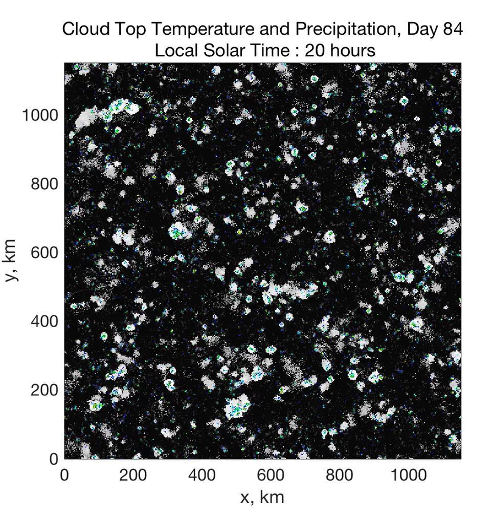
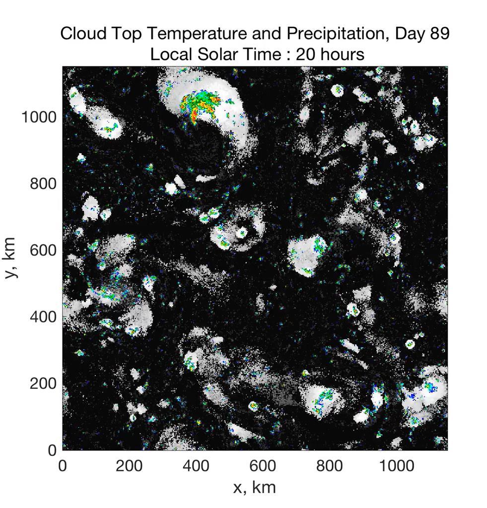
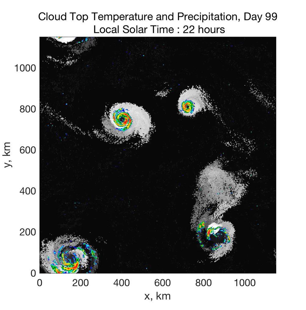
16 Airborne Radar: Vertical Slice 20 km (12 mi) 120 km (75 mi)


17 Hurricane Structure: Wind Speed Azimuthal component of wind < 11 5 ms -1 - > 60 ms -1

18 Vertical Air Motion Updraft Speed Strong upward motion in the eyewall
19 Specific entropy

20 Absolute angular momentum per unit mass M rv r 2
21 Starting Point: Radiative-Moist Convective Equilibrium Equilibrium state in which convective and radiative energy fluxes balance at each altitude Vertical profile nearly neutral to moist convection Strongly-two way interaction: Radiation drives profile toward instability, convection lofts water that strongly affects radiative transfer Jump in humidity near ocean surface

22 Majuro, 00 GMT August 2, 2015

23 The radiation physicist s heart knoweth its own bitterness, but a stranger meddleth not with its joy

24 Cloud-permitting models of radiative-convective equilibrium run in moderately large domains Example: System for Atmospheric Modeling (SAM) of Khairoutdinov and Randall (2003) 28 km Rigid Lid Fixed SST 300 K 1152 km Horizontal Resolution: 2km Vertical Resolution: 64 levels Periodic lateral boundaries Initial sounding from domain average of smaller domain run in RCE No solar fluxes; specified radiative cooling rate km Courtesy Tim Cronin, MIT
25
26
27
28
29 Physics of Mature Hurricanes
 Ocean")
30 Height above ocean Cross-section through a Hurricane & Energy Production eye edge Isothermal compression Nearly isothermal expansion Low entropy Radius (km) Ocean surface
31 Carnot Theorem: Maximum efficiency results from a particular energy cycle: Isothermal expansion Adiabatic expansion Isothermal compression Adiabatic compression Note: Last leg is not adiabatic in hurricanes: Air cools radiatively. But since the environmental temperature profile is moist adiabatic, the amount of radiative cooling is the same as if air were saturated and descending moist adiabatically. Maximum rate of energy production: P T s T s T o Q&
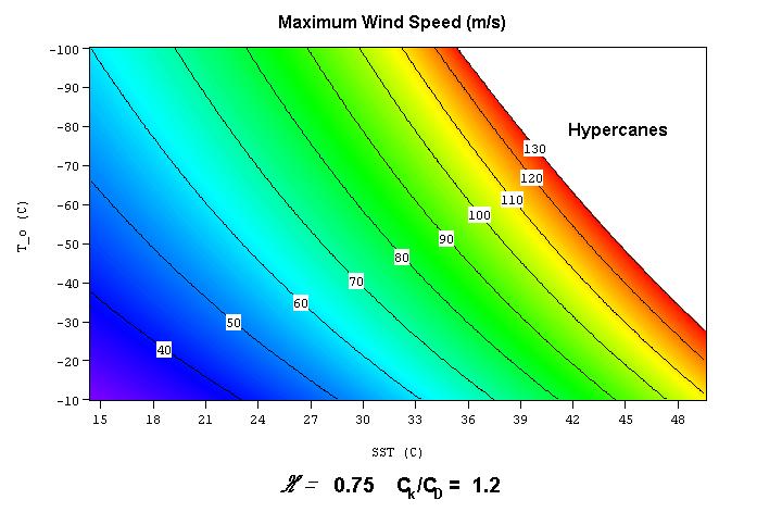
32 Theoretical Upper Bound on Hurricane Maximum Wind Speed: Surface temperature C T T V 2 k s o k * max k C T 0 D o Ratio of exchange coefficients of enthalpy and Outflow temperature momentum p v Air-sea enthalpy disequilibrium k c T L q
33
34 Annual Maximum Potential Intensity (m/s) 60 o N 30 o N 0 o 30 o S 60 o S 0 o 60 o E 120 o E 180 o W 120 o W 60 o W
35 Dependence on Sea Surface Temperature (SST): Potential Intensity is not the same thing as SST!
36 QUIZ Tropical cyclones are powered by 1. Latent heat 2. Surface heat fluxes 3. Horizontal temperature gradients The upper limit on hurricane wind speeds is determined by 1. Sea surface temperature 2. How warm the ocean is relative to the atmosphere above
37 Relationship between potential intensity (PI) and intensity of real tropical cyclones
38
39
40 Why do real storms seldom reach their thermodynamic potential? One Reason: Ocean Interaction

41 Strong Mixing of Upper Ocean

42 Mixed layer depth and currents

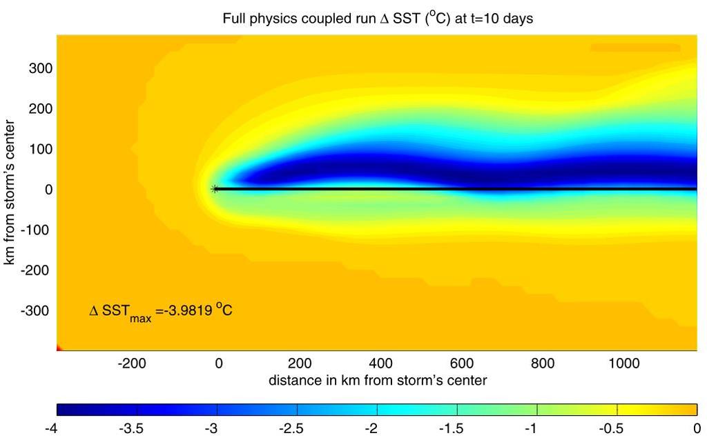
43 SST Change
44 Comparing Fixed to Interactive SST:
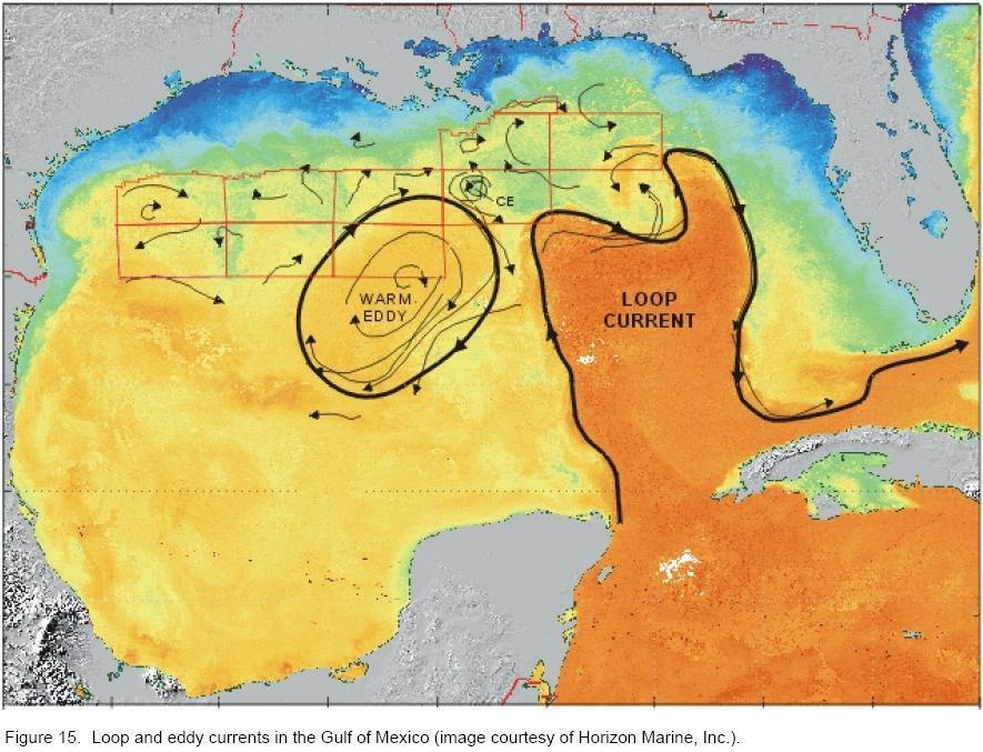
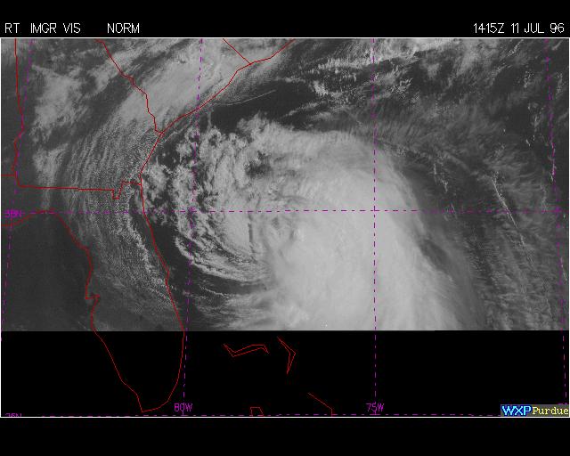
45 A good simulation of Camille can only be obtained by assuming that it traveled right up the axis of the Loop Current:
46

47 Loop Current

48 Wind Shear
49 Shear appears to weaken TCs by blowing dry, low theta_e air into the core
50 Statistics of Hurricane Intensification Common logarithms of the probability densities of open-ocean tropical cyclone intensity change rates in the North Atlantic region from 3504 observations (blue) and from synthetic samples (red) of hurricane-intensity storms. Green lines or dots indicate the 5th and 95th percentiles of 1000 subsamples of the synthetic tracks data at the rate of the observed data for each intensity change bin. All distributions are bounded below by The synthetic data are subsampled every 6 h and rounded to 5 kt to match the best track data
51 Tropical Cyclone Motion
52 Tropical cyclones move approximately with a suitably defined vertical vector average of the flow in which they are embedded
53
54
55 Latitude Longitude
56 Lagrangian chaos:
57 Vortices in interacting with Earth s vorticity:
58 Baroclinic vortices in shear: A simple model Two layers, with upper layer moving with respect to lower layer Lower layer contains point vortex, whose circulation projects outward and upward Upper layer has point source of zero vorticity air colocated with lower point vortex; zero PV air separated from surroundings by a single, expanding contour (From Wu and Emanuel, 1993)
59 Lower (left) and upper (right) flows for zero shear:
60 Evolution of upper layer vortex patch when weak shear is present
61 Evolution of upper layer vortex patch when moderate shear is present
62 Evolution of upper layer vortex patch when strong shear is present
63
64 Hurricanes and Climate
65 Prior to 1970, Many Storms Were Missed Major hurricanes in the North Atlantic, , smoothed using a 10- year running average. Shown in blue are storms that either passed through the chain of Lesser Antilles or made landfall in the continental U.S.; all other major hurricanes are shown in red. The dashed lines show the best fit trend lines for each data set.

66 Trends in Global TC Frequency Over Threshold Intensities, from Historical TC Data, Trends Shown Only When p < 0.05.

67 Hurricanes are reaching peak intensity at higher latitudes Time series of the latitudes at which tropical cyclones reach maximum intensity. From Kossin et al. (2014)
 ms")
68 Trends in Thermodynamic Potential for Hurricanes, (NCAR/NCEP Reanalysis) ms -1 decade -1

69 Projected Trend Over 21 st Century: GFDL model under RCP 8.5 ms -1 decade -1
70 Inferences from Basic Theory: Potential intensity increases with global warming Incidence of high-intensity hurricanes should increase Increases in potential intensity should be faster in sub-tropics Hurricanes will produce substantially more rain: Clausius-Clapeyron yields ~7% increase in water vapor per 1 o C warming
71 2017 Hurricane Records Harvey s storm total rainfall was largest ever recorded from a hurricane in the U.S. Hurricane Irma sustained Category 5 winds for longer than ever recorded in any tropical cyclone on the planet Hurricane Irma was the first recorded Atlantic hurricane to reach Cat 4 status outside the Caribbean and the second strongest hurricane ever recorded in the Atlantic The 2017 hurricanes caused more than $300 billion in damages, the largest of any hurricane season on record

72 Dominica in the wake of Hurricane Maria

73 Probability of Storm Accumulated Rainfall at Houston, from 6 Climate models, and , Based on 2000 Events Each. Shading shows spread among the models. Harvey

74 Probabilities of Storms of Irma s Intensity within 300 km of Barbuda, from 6 Climate models, and , Based on 2000 Events Each. Shading shows spread among the models.

75 Summary Hurricanes appear to result from the instability of the radiative-convective equilibrium of the tropical atmosphere Hurricanes are almost perfect Carnot heat engines, operating off the thermodynamic disequilibrium between the tropical ocean and atmosphere, made possible by the greenhouse effect
76 Most hurricanes are prevented from reaching their potential intensity by storm-induced ocean cooling and environmental wind shear Hurricanes move with some vertical average of the environmental flow plus effects due to the earth s rotation and curvature, and to wind shear
77 Hurricanes are expected to become more intense and rain more as the climate warms
Hurricanes: Their physics and relationship to climate. Kerry Emanuel Massachusetts Institute of Technology
 Hurricanes: Their physics and relationship to climate Kerry Emanuel Massachusetts Institute of Technology Topics Overview of Tropical Cyclones Tropical Cyclone Physics What have TCs been like in the past,
Inner core dynamics: Eyewall Replacement and hot towers
 Inner core dynamics: Eyewall Replacement and hot towers FIU Undergraduate Hurricane Internship Lecture 4 8/13/2012 Why inner core dynamics is important? Current TC intensity and structure forecasts contain
Annual Number of Peer Reviewed Articles with Hurricane or Tropical Cyclone in their Titles, according to Meteorological and Geoastrophysical
 Hurricanes and Climate Kerry Emanuel Program in Atmospheres, Oceans, and Climate MIT Program Potential Intensity Role of potential ti li intensity it in storm intensity it Role of potential intensity in
Ch. 11: Hurricanes. Be able to. Define what hurricane is. Identify the life and death of a hurricane. Identify the ways we track hurricanes.
 Ch. 11: Hurricanes Be able to Define what hurricane is. Identify the life and death of a hurricane. Identify the ways we track hurricanes. What are Hurricanes? Smaller than mid-latitude cyclones. Don t
Hurricanes in the Gulf of Mexico: The History and Future of the Texas Coast
 # 82 Hurricanes in the Gulf of Mexico: The History and Future of the Texas Coast Dr. Kerry Emanuel January 8, 2013 Produced by and for Hot Science - Cool Talks by the Environmental Science Institute. We
Tropical Cyclone Genesis: What we know, and what we don t!
 Tropical Cyclone Genesis: What we know, and what we don t! Allison Wing! NSF Postdoctoral Research Fellow! Lamont-Doherty Earth Observatory! Columbia University! Overview! Climatology! What We Know! Theories!
Hurricanes are intense vortical (rotational) storms that develop over the tropical oceans in regions of very warm surface water.
 storms that develop over the tropical oceans in regions of very warm surface water.") Hurricanes: Observations and Dynamics Houze Section 10.1. Holton Section 9.7. Emanuel, K. A., 1988: Toward a general theory of hurricanes. American Scientist, 76, 371-379 (web link). http://ww2010.atmos.uiuc.edu/(gh)/guides/mtr/hurr/home.rxml
Hurricanes: Observations and Dynamics Houze Section 10.1. Holton Section 9.7. Emanuel, K. A., 1988: Toward a general theory of hurricanes. American Scientist, 76, 371-379 (web link). http://ww2010.atmos.uiuc.edu/(gh)/guides/mtr/hurr/home.rxml
Tropical Cyclones. Objectives
 Tropical Cyclones FIU Undergraduate Hurricane Internship Lecture 2 8/8/2012 Objectives From this lecture you should understand: Global tracks of TCs and the seasons when they are most common General circulation
Hurricanes and Tropical Weather Systems:
 Hurricanes and Tropical Weather Systems: An influence on weather in parts of the USA Meteorology 411 Iowa State University Week 2 Bill Gallus Classification/Terminology Tropical Disturbance enhanced convection
Tropical Cyclones and Climate Change: Historical Trends and Future Projections
 Tropical Cyclones and Climate Change: Historical Trends and Future Projections Thomas R. Knutson Geophysical Fluid Dynamics Laboratory / NOAA, Princeton, NJ U.S.A. IOGP/JCOMM/WCRP Workshop September 25-27,
Chapter 24. Tropical Cyclones. Tropical Cyclone Classification 4/19/17
 Chapter 24 Tropical Cyclones Tropical Cyclones Most destructive storms on the planet Originate over tropical waters, but their paths often take them over land and into midlatitudes Names Hurricane (Atlantic
Radiative-Convective Instability
 Radiative-Convective Instability Kerry Emanuel, Allison Wing, and Emmanuel Vincent Massachusetts Institute of Technology Self-Aggregation of Deep Moist Convection Cloud Clusters Tropical Cyclone Genesis
Intensity of North Indian Ocean Tropical Cyclones
 Chapter 6 Intensity of North Indian Ocean Tropical Cyclones 6.1 Introduction Intensity of tropical cyclones is dependent on several parameters both thermodynamic and dynamic. It includes thermodynamic
Chapter 24 Tropical Cyclones
 Chapter 24 Tropical Cyclones Tropical Weather Systems Tropical disturbance a cluster of thunderstorms about 250 to 600 km in diameter, originating in the tropics or sub-tropics Tropical depression a cluster
AnuMS 2018 Atlantic Hurricane Season Forecast
 AnuMS 2018 Atlantic Hurricane Season Forecast Issued: May 10, 2018 by Dale C. S. Destin (follow @anumetservice) Director (Ag), Antigua and Barbuda Meteorological Service (ABMS) The *AnuMS (Antigua Met
Hurricanes. Hurricanes are large, tropical storm systems that form and develop over the warm waters near the equator.
 Hurricanes Hurricanes are large, tropical storm systems that form and develop over the warm waters near the equator. They are responsible for weather that can devastate entire communities: Heavy rain --
The Tropical Atmosphere: Hurricane Incubator
 The Tropical Atmosphere: Hurricane Incubator Images from journals published by the American Meteorological Society are copyright AMS and used with permission. A One-Dimensional Description of the Tropical
Extreme Weather and Climate Change: the big picture Alan K. Betts Atmospheric Research Pittsford, VT NESC, Saratoga, NY
 Extreme Weather and Climate Change: the big picture Alan K. Betts Atmospheric Research Pittsford, VT http://alanbetts.com NESC, Saratoga, NY March 10, 2018 Increases in Extreme Weather Last decade: lack
Lecture 18 Hurricanes
 Lecture 18 Hurricanes Part I Structure and Climatology What is a hurricane? What is the structure or anatomy of a hurricane? How to build a hurricane - hurricane energy Hurricane climatology - when and
Adiabatic expansion Isothermal compression Adiabatic compression
 Tropical Cyclones: Steady State Physics 1 Energy Production 2 Carnot Theorem: Maximum efficiency results from a pa rticular energy e cycle: Isothermal expansion Adiabatic expansion Isothermal compression
Thermodynamic and Flux Observations of the Tropical Cyclone Surface Layer
 Thermodynamic and Flux Observations of the Tropical Cyclone Surface Layer 1. INTRODUCTION Alex M. Kowaleski and Jenni L. Evans 1 The Pennsylvania State University, University Park, PA Understanding tropical
Lessons Learned from Hurricane Harvey and Irma
 EOL Visit to NSF 3 March 2016 Lessons Learned from Hurricane Harvey and Irma Wen-Chau Lee National Center for Atmospheric Research 23 November 2017 Outline: Meteorological elements of the active 2017 Atlantic
Lectures on Tropical Cyclones
 Lectures on Tropical Cyclones Chapter 1 Observations of Tropical Cyclones Outline of course Introduction, Observed Structure Dynamics of Mature Tropical Cyclones Equations of motion Primary circulation
AnuMS 2018 Atlantic Hurricane Season Forecast
 AnuMS 2018 Atlantic Hurricane Season Forecast Issued: April 10, 2018 by Dale C. S. Destin (follow @anumetservice) Director (Ag), Antigua and Barbuda Meteorological Service (ABMS) The *AnuMS (Antigua Met
Hurricanes Part I Structure and Climatology by Professor Steven Businger. Hurricane Katrina
 Hurricanes Part I Structure and Climatology by Professor Steven Businger Hurricane Katrina Hurricanes Part I Structure and Climatology by Professor Steven Businger What is a hurricane? What is the structure
PRMS WHITE PAPER 2014 NORTH ATLANTIC HURRICANE SEASON OUTLOOK. June RMS Event Response
 PRMS WHITE PAPER 2014 NORTH ATLANTIC HURRICANE SEASON OUTLOOK June 2014 - RMS Event Response 2014 SEASON OUTLOOK The 2013 North Atlantic hurricane season saw the fewest hurricanes in the Atlantic Basin
Presentation A simple model of multiple climate regimes
 A simple model of multiple climate regimes Kerry Emanuel March 21, 2012 Overview 1. Introduction 2. Essential Climate Feedback Processes Ocean s Thermohaline Circulation, Large-Scale Circulation of the
Hurricane: an organized tropical storm system featuring vigorous convection and sustained winds in excess of 64 knots (74 mph)
") Hurricane: an organized tropical storm system featuring vigorous convection and sustained winds in excess of 64 knots (74 mph) The storms have different names, depending on where they form: Western Hemisphere:
Hurricane: an organized tropical storm system featuring vigorous convection and sustained winds in excess of 64 knots (74 mph) The storms have different names, depending on where they form: Western Hemisphere:
AnuMS 2018 Atlantic Hurricane Season Forecast
 AnuMS 2018 Atlantic Hurricane Season Forecast : June 11, 2018 by Dale C. S. Destin (follow @anumetservice) Director (Ag), Antigua and Barbuda Meteorological Service (ABMS) The *AnuMS (Antigua Met Service)
August Forecast Update for Atlantic Hurricane Activity in 2012
 August Forecast Update for Atlantic Hurricane Activity in 2012 Issued: 6 th August 2012 by Professor Mark Saunders and Dr Adam Lea Dept. of Space and Climate Physics, UCL (University College London), UK
Exploring the Use of Dynamical Weather and Climate Models for Risk Assessment
 Exploring the Use of Dynamical Weather and Climate Models for Risk Assessment James Done Willis Research Network Fellow National Center for Atmospheric Research Boulder CO, US Leverages resources in the
Kevin E Trenberth NCAR
 Attribution of Recent Increases in Atlantic Hurricane Activity Kevin E Trenberth NCAR Issues for detection and attribution of changes in hurricanes What has happened? How good is the observational record?
Meteorology Lecture 21
 Meteorology Lecture 21 Robert Fovell rfovell@albany.edu 1 Important notes These slides show some figures and videos prepared by Robert G. Fovell (RGF) for his Meteorology course, published by The Great
IV. Atmospheric Science Section
 EAPS 100 Planet Earth Lecture Topics Brief Outlines IV. Atmospheric Science Section 1. Introduction, Composition and Structure of the Atmosphere Learning objectives: Understand the basic characteristics
ARUBA CLIMATOLOGICAL SUMMARY 2017 PRECIPITATION
 ARUBA CLIMATOLOGICAL SUMMARY 2017 PRECIPITATION The total amount of rainfall recorded at Reina Beatrix International Airport for the year 2017 was 391.0 mm. This is 17.1 % below normal ( Figure 1 ). During
Huracan: evil Taino & Mayan god of winds & destruction
 Huracan: evil Taino & Mayan god of winds & destruction Profile of a Tropical Cyclone! Hurricane = typhoon = cyclone! All different words for the same thing Eye: clear area in the center Eyewall: clouds
11/17/2017. Memorable Hurricanes of 2004 MET 4532
 MET 4532 2004 Hurricane Season Lecture 31 & 32 2004, 2005, and After 17-20 November 2017 1 2 Memorable Hurricanes of 2004 Hurricane Dates Damage (US) Deaths (US) Charlie (4) 9-14 AUG $14B 10 Ivan (4) 2-24
2016 Hurricane Season Preview
 2016 Hurricane Season Preview Eric Uhlhorn, Ph.D. 1 2 Recap of 2015 Hurricane Season - El Niño played a significant role in activity - Atlantic activity was slightly below normal 11 named storms, 4 hurricanes,
AnuMS 2018 Atlantic Hurricane Season Forecast
 AnuMS 2018 Atlantic Hurricane Season : August 12, 2018 by Dale C. S. Destin (follow @anumetservice) Director (Ag), Antigua and Barbuda Meteorological Service (ABMS) The *AnuMS (Antigua Met Service) is
April Forecast Update for North Atlantic Hurricane Activity in 2019
 April Forecast Update for North Atlantic Hurricane Activity in 2019 Issued: 5 th April 2019 by Professor Mark Saunders and Dr Adam Lea Dept. of Space and Climate Physics, UCL (University College London),
The 2009 Hurricane Season Overview
 The 2009 Hurricane Season Overview Jae-Kyung Schemm Gerry Bell Climate Prediction Center NOAA/ NWS/ NCEP 1 Overview outline 1. Current status for the Atlantic, Eastern Pacific and Western Pacific basins
地球系统科学前沿讲座 台风研究现状和问题 林岩銮
 地球系统科学前沿讲座 台风研究现状和问题 林岩銮 2013.3.18 Satellite image of Hurricane Floyd approaching the east coast of Florida in 1999. The image has been digitally enhanced to lend a three-dimensional perspective. Credit:
August Forecast Update for Atlantic Hurricane Activity in 2016
 August Forecast Update for Atlantic Hurricane Activity in 2016 Issued: 5 th August 2016 by Professor Mark Saunders and Dr Adam Lea Dept. of Space and Climate Physics, UCL (University College London), UK
A Preliminary Exploration of the Upper Bound of Tropical Cyclone Intensification
 A Preliminary Exploration of the Upper Bound of Tropical Cyclone Intensification Jonathan L. Vigh (NCAR/RAL) Kerry Emanuel (MIT) Mrinal K. Biswas (NCAR/RAL) Eric A. Hendricks (Naval Postgraduate School)
Foundations of Earth Science, 6e Lutgens, Tarbuck, & Tasa
 Foundations of Earth Science, 6e Lutgens, Tarbuck, & Tasa Weather Patterns and Severe Weather Foundations, 6e - Chapter 14 Stan Hatfield Southwestern Illinois College Air masses Characteristics Large body
A Hurricane Outlook for the 21st Century.
 A Hurricane Outlook for the 21st Century. Hugh Willoughby Florida International University Cat Winds Effects One 74-95 mph No real damage to building structures. Two Three Four Five 96-110 mph 111-130
Tuesday, September 13, 16
 Weather Weather State Objectives 4.c, 4.d, 4.h. Discussion What are some ways in which weather affects your everyday life? Discussion What are some ways in which weather affects your everyday life? What
Why the Atlantic was surprisingly quiet in 2013
 1 Why the Atlantic was surprisingly quiet in 2013 by William Gray and Phil Klotzbach Preliminary Draft - March 2014 (Final draft by early June) ABSTRACT This paper discusses the causes of the unusual dearth
4. Climatic changes. Past variability Future evolution
 4. Climatic changes Past variability Future evolution TROPICAL CYCLONES and CLIMATE How TCs have varied during recent and distant past? How will TC activity vary in the future? 2 CURRENT CLIMATE : how
(April 7, 2010, Wednesday) Tropical Storms & Hurricanes Part 2
 Tropical Storms & Hurricanes Part 2") Lecture #17 (April 7, 2010, Wednesday) Tropical Storms & Hurricanes Part 2 Hurricane Katrina August 2005 All tropical cyclone tracks (1945-2006). Hurricane Formation While moving westward, tropical disturbances
Lecture #17 (April 7, 2010, Wednesday) Tropical Storms & Hurricanes Part 2 Hurricane Katrina August 2005 All tropical cyclone tracks (1945-2006). Hurricane Formation While moving westward, tropical disturbances
2013 ATLANTIC HURRICANE SEASON OUTLOOK. June RMS Cat Response
 2013 ATLANTIC HURRICANE SEASON OUTLOOK June 2013 - RMS Cat Response Season Outlook At the start of the 2013 Atlantic hurricane season, which officially runs from June 1 to November 30, seasonal forecasts
Introduction to Meteorology & Climate. Climate & Earth System Science. Atmosphere Ocean Interactions. A: Structure of the Ocean.
 Climate & Earth System Science Introduction to Meteorology & Climate MAPH 10050 Peter Lynch Peter Lynch Meteorology & Climate Centre School of Mathematical Sciences University College Dublin Meteorology
Interhemispheric climate connections: What can the atmosphere do?
 Interhemispheric climate connections: What can the atmosphere do? Raymond T. Pierrehumbert The University of Chicago 1 Uncertain feedbacks plague estimates of climate sensitivity 2 Water Vapor Models agree
What We Know about the Climate Change Hurricane Connection Some links are indisputable; others are more subtle, but the science is improving all the
 What We Know about the Climate Change Hurricane Connection Some links are indisputable; others are more subtle, but the science is improving all the time By Michael E. Mann, Thomas C. Peterson, Susan Joy
Hurricane Intensity: Governing Factors and Forecasting Challenges. EAS 470 Final Paper Allison Wing
 Hurricane Intensity: Governing Factors and Forecasting Challenges EAS 470 Final Paper Allison Wing Tropical cyclones are undoubtedly among the mostly deadly and destructive natural phenomena found on Earth
Introduction to Climate ~ Part I ~
 2015/11/16 TCC Seminar JMA Introduction to Climate ~ Part I ~ Shuhei MAEDA (MRI/JMA) Climate Research Department Meteorological Research Institute (MRI/JMA) 1 Outline of the lecture 1. Climate System (
Transient and Eddy. Transient/Eddy Flux. Flux Components. Lecture 3: Weather/Disturbance. Transient: deviations from time mean Time Mean
 Lecture 3: Weather/Disturbance Transients and Eddies Climate Roles Mid-Latitude Cyclones Tropical Hurricanes Mid-Ocean Eddies Transient and Eddy Transient: deviations from time mean Time Mean Eddy: deviations
August Forecast Update for Atlantic Hurricane Activity in 2015
 August Forecast Update for Atlantic Hurricane Activity in 2015 Issued: 5 th August 2015 by Professor Mark Saunders and Dr Adam Lea Dept. of Space and Climate Physics, UCL (University College London), UK
ovember 2008 Antigua and Barbuda Meteorological Service
 ovember 2008 Antigua and Barbuda Meteorological Service The Atlantic Hurricane Season Summary 2008 Special Focus on Antigua and Barbuda The Season in Brief Sixteen (16) named storms formed in the Atlantic
Macroeconomic implications of natural disasters on small economies
 Macroeconomic implications of natural disasters on small economies Sebastian Acevedo IMF Western Hemisphere Department Central Bank of Curaçao and Sint Maarten March 22, 2018 Disclaimer: The views expressed
April Forecast Update for Atlantic Hurricane Activity in 2018
 April Forecast Update for Atlantic Hurricane Activity in 2018 Issued: 5 th April 2018 by Professor Mark Saunders and Dr Adam Lea Dept. of Space and Climate Physics, UCL (University College London), UK
and Weather extremes Tropical cyclones Today and in the Future Greg Holland c3we.ucar.edu
 Tropical cyclones and Weather extremes Today and in the Future c3we.ucar.edu Greg Holland (gholland@ucar.edu) Supported by NSF, Willis Re, IAG, and Zurich Insurance 1 Topics State of the Climate and its
Link between Hurricanes and Climate Change: SST
 Link between Hurricanes and Climate Change: SST FRIDAY: PROJECT 2 Proposals due! Bring laptops on weds (at least one per group)! Discuss assessment on Weds. Roger Francois will talk on Friday about the
Tropical Storms & Hurricanes Part 1. August 1992
 Lecture #16 (April 5, 2010, Monday) Tropical Storms & Hurricanes Part 1 August 1992 Tracks of rain accumulation & clouds from Hurricane Rita September 2005 Tropical Cyclones Around the Globe Why none here?
July Forecast Update for Atlantic Hurricane Activity in 2016
 July Forecast Update for Atlantic Hurricane Activity in 2016 Issued: 5 th July 2016 by Professor Mark Saunders and Dr Adam Lea Dept. of Space and Climate Physics, UCL (University College London), UK Forecast
Will a warmer world change Queensland s rainfall?
 Will a warmer world change Queensland s rainfall? Nicholas P. Klingaman National Centre for Atmospheric Science-Climate Walker Institute for Climate System Research University of Reading The Walker-QCCCE
Introduction. One way to monitor the status of this energy is though monitoring sea surface
 Sears 1 Understanding Hurricane Intensity Using Sea Surface Height and Temperature Information John Sears (Plymouth State University) Robbie Hood (NASA-MSFC) Frank LaFontaine (Raytheon) Abstract Warmer
TROPICAL CYCLONES AND THE CLIMATE OF THE EARLY PLIOCENE
 TROPICAL CYCLONES AND THE CLIMATE OF THE EARLY PLIOCENE Chris Brierley With Alexey Fedorov (Yale), Zhonghui Liu (Hong Kong), Kerry Emanuel (MIT) and Tim Herbert (Brown) Outline Introduction to the early
July Forecast Update for Atlantic Hurricane Activity in 2017
 July Forecast Update for Atlantic Hurricane Activity in 2017 Issued: 4 th July 2017 by Professor Mark Saunders and Dr Adam Lea Dept. of Space and Climate Physics, UCL (University College London), UK Forecast
Vertical structure of the atmosphere
 Vertical structure of the atmosphere Stratosphere ozone layer / ozone hole ultraviolet solar radiation sulfate aerosols from volcanic eruptions increasing GHG produces cooling Troposphere most clouds
The Impact of air-sea interaction on the extratropical transition of tropical cyclones
 The Impact of air-sea interaction on the extratropical transition of tropical cyclones Sarah Jones Institut für Meteorologie und Klimaforschung Universität Karlsruhe / Forschungszentrum Karlsruhe 1. Introduction
ENSO Outlook by JMA. Hiroyuki Sugimoto. El Niño Monitoring and Prediction Group Climate Prediction Division Japan Meteorological Agency
 ENSO Outlook by JMA Hiroyuki Sugimoto El Niño Monitoring and Prediction Group Climate Prediction Division Outline 1. ENSO impacts on the climate 2. Current Conditions 3. Prediction by JMA/MRI-CGCM 4. Summary
SUPPLEMENTAL MATERIALS FOR:
 SUPPLEMENTAL MATERIALS FOR: Simulated reduction in Atlantic hurricane frequency under 21 st century warming conditions Thomas R. Knutson, Joseph J. Sirutis, Stephen T. Garner, Gabriel A. Vecchi, and Isaac
Radiative-Convective Instability. Kerry Emanuel Massachusetts Institute of Technology
 Radiative-Convective Instability Kerry Emanuel Massachusetts Institute of Technology Program Basic radiative-convective equilibrium Macro-instability of the RC state Some consequences Radiative Equilibrium
El Niño Update Impacts on Florida
 Current Issues in Emergency Management (CIEM) Sessions 1 &2 October 12 th and 26 th, 2006 Florida Division of Emergency Management Tallahassee, Florida El Niño Update Impacts on Florida Bart Hagemeyer
Forecasting Hurricane Intensity: Lessons from Application of the Coupled Hurricane Intensity Prediction System (CHIPS)
") Forecasting Hurricane Intensity: Lessons from Application of the Coupled Hurricane Intensity Prediction System (CHIPS) Coupled Model Design Atmospheric Component: (from Emanuel, 1995) Gradient and hydrostatic
Forecasting Hurricane Intensity: Lessons from Application of the Coupled Hurricane Intensity Prediction System (CHIPS) Coupled Model Design Atmospheric Component: (from Emanuel, 1995) Gradient and hydrostatic
Observed Climate Variability and Change: Evidence and Issues Related to Uncertainty
 Observed Climate Variability and Change: Evidence and Issues Related to Uncertainty David R. Easterling National Climatic Data Center Asheville, North Carolina Overview Some examples of observed climate
The meteorology of monsoons
 978--521-84799-5 - The Asian Monsoon: Causes, History and Effects 1 The meteorology of monsoons 1.1 Introduction Monsoon circulations are major features of the tropical atmosphere, which, primarily through
Research on Climate of Typhoons Affecting China
 Research on Climate of Typhoons Affecting China Xu Ming Shanghai Typhoon Institute November,25 Outline 1. Introduction 2. Typhoon disasters in China 3. Climatology and climate change of typhoon affecting
Tropical Cyclones: Steady State Physics
 Tropical Cyclones: Steady State Physics Energy Production Carnot Theorem: Maximum efficiency results from a particular energy cycle: Isothermal expansion Adiabatic expansion Isothermal compression Adiabatic
July Forecast Update for North Atlantic Hurricane Activity in 2018
 July Forecast Update for North Atlantic Hurricane Activity in 2018 Issued: 5 th July 2018 by Professor Mark Saunders and Dr Adam Lea Dept. of Space and Climate Physics, UCL (University College London),
Module 11: Meteorology Topic 6 Content: Severe Weather Notes
 Severe weather can pose a risk to you and your property. Meteorologists monitor extreme weather to inform the public about dangerous atmospheric conditions. Thunderstorms, hurricanes, and tornadoes are
Pre-Season Forecast for North Atlantic Hurricane Activity in 2018
 Pre-Season Forecast for North Atlantic Hurricane Activity in 2018 Issued: 30 th May 2018 by Professor Mark Saunders and Dr Adam Lea Dept. of Space and Climate Physics, UCL (University College London),
1. What type of wind is needed for a hurricane to form? Low to medium winds, blowing in the same direction (weak wind shear).
.") Explain 1. What type of wind is needed for a hurricane to form? Low to medium winds, blowing in the same direction (weak wind shear). 2. What is wind shear? Any change in wind speed or direction. When
Explain 1. What type of wind is needed for a hurricane to form? Low to medium winds, blowing in the same direction (weak wind shear). 2. What is wind shear? Any change in wind speed or direction. When
Section 13-1: Thunderstorms
 Section 13-1: Thunderstorms Chapter 13 Main Idea: The intensity and duration of thunderstorms depend on the local conditions that create them. Air-mass thunderstorm Mountain thunderstorm Sea-breeze thunderstorm
LECTURE #18: Hurricane Damage, Monitoring & Case Study
 GEOL 0820 Ramsey Natural Disasters Spring, 2018 LECTURE #18: Hurricane Damage, Monitoring & Case Study Date: 27 March 2018 I. Exam II grades now posted online o high: 98, low: 46, average: 80 (~3 points
Extreme Rainfall in the Southeast U.S.
 Extreme Rainfall in the Southeast U.S. David F. Zierden Florida State Climatologist Center for Ocean Atmospheric Prediction Studies The Florida State University March 7, 2016 Causes of Extreme Rainfall
Hurricane Structure: Theory and Diagnosis
 Hurricane Structure: Theory and Diagnosis 7 March, 2016 World Meteorological Organization Workshop Chris Landsea Chris.Landsea@noaa.gov National Hurricane Center, Miami Outline Structure of Hurricanes
Radiative-Convective Models. The Hydrological Cycle Hadley Circulation. Manabe and Strickler (1964) Course Notes chapter 5.1
 Course Notes chapter 5.1") Climate Modeling Lecture 8 Radiative-Convective Models Manabe and Strickler (1964) Course Notes chapter 5.1 The Hydrological Cycle Hadley Circulation Prepare for Mid-Term (Friday 9 am) Review Course Notes
Climate Modeling Lecture 8 Radiative-Convective Models Manabe and Strickler (1964) Course Notes chapter 5.1 The Hydrological Cycle Hadley Circulation Prepare for Mid-Term (Friday 9 am) Review Course Notes
Crux of AGW s Flawed Science (Wrong water-vapor feedback and missing ocean influence)
") 1 Crux of AGW s Flawed Science (Wrong water-vapor feedback and missing ocean influence) William M. Gray Professor Emeritus Colorado State University There are many flaws in the global climate models. But
1 Crux of AGW s Flawed Science (Wrong water-vapor feedback and missing ocean influence) William M. Gray Professor Emeritus Colorado State University There are many flaws in the global climate models. But
Hurricane Harvey the Name says it all. by Richard H. Grumm and Charles Ross National Weather Service office State College, PA
 Hurricane Harvey the Name says it all by Richard H. Grumm and Charles Ross National Weather Service office State College, PA 16803. 1. Overview Hurricane Harvey crossed the Texas coast (Fig. 1) as a category
Atmospheric Moisture, Precipitation, and Weather Systems
 Atmospheric Moisture, Precipitation, and Weather Systems 6 Chapter Overview The atmosphere is a complex system, sometimes described as chaotic in nature. In this chapter we examine one of the principal
Water in the Atmosphere The Role of Water in Earth s Surface Processes. Hurricane Warning
 Hurricane Warning 1 Earth, the lue Planet. What makes Earth blue? It has to do with all of the water on Earth. There is water in more places than the vast oceans. Water is also in the atmosphere. High
Comments by William M. Gray (Colorado State University) on the recently published paper in Science by Webster, et al
 on the recently published paper in Science by Webster, et al") Comments by William M. Gray (Colorado State University) on the recently published paper in Science by Webster, et al., titled Changes in tropical cyclone number, duration, and intensity in a warming environment
Comments by William M. Gray (Colorado State University) on the recently published paper in Science by Webster, et al., titled Changes in tropical cyclone number, duration, and intensity in a warming environment
LECTURE #17: Severe Weather: Introduction to Hurricanes
 GEOL 0820 Ramsey Natural Disasters Spring, 2018 LECTURE #17: Severe Weather: Introduction to Hurricanes Date: 15 March 2018 I. Hurricane Overview hurricanes o what they are? o how they form? storm stages:
Hurricanes and Climate Change: Expectations versus Observations
 Hurricanes and Climate Change: Expectations versus Observations 15 June, 2010 Lloyd s Market Academy Chris Landsea, National Hurricane Center, Miami, USA Chris.Landsea@noaa.gov How is global warming affecting:
p = ρrt p = ρr d = T( q v ) dp dz = ρg
 dp dz = ρg") Chapter 1: Properties of the Atmosphere What are the major chemical components of the atmosphere? Atmospheric Layers and their major characteristics: Troposphere, Stratosphere Mesosphere, Thermosphere
Chapter 1: Properties of the Atmosphere What are the major chemical components of the atmosphere? Atmospheric Layers and their major characteristics: Troposphere, Stratosphere Mesosphere, Thermosphere
Global Climate Change and Human Health Cycloning out of Control: Climate Change Impacts on Natural Disasters; Cyclones
 INSTRUCTOR BACKGROUND Cyclones are one of the world s most devastating natural disasters causing billions of dollars in damages to homes, building and infrastructure annually. The United Nations estimates
South Eastern Australian Rainfall in relation to the Mean Meridional Circulation
 South Eastern Australian Rainfall in relation to the Mean Meridional Circulation Bertrand Timbal, Hanh Nguyen, Robert Fawcett, Wasyl Drosdowsky and Chris Lucas CAWCR / Bureau of Meteorology Long-term SEA
The Arctic Energy Budget
 The Arctic Energy Budget The global heat engine [courtesy Kevin Trenberth, NCAR]. Differential solar heating between low and high latitudes gives rise to a circulation of the atmosphere and ocean that