Approve or disapprove Concept Plan as presented. (II A)
|
|
|
- Alan Stone
- 5 years ago
- Views:
Transcription

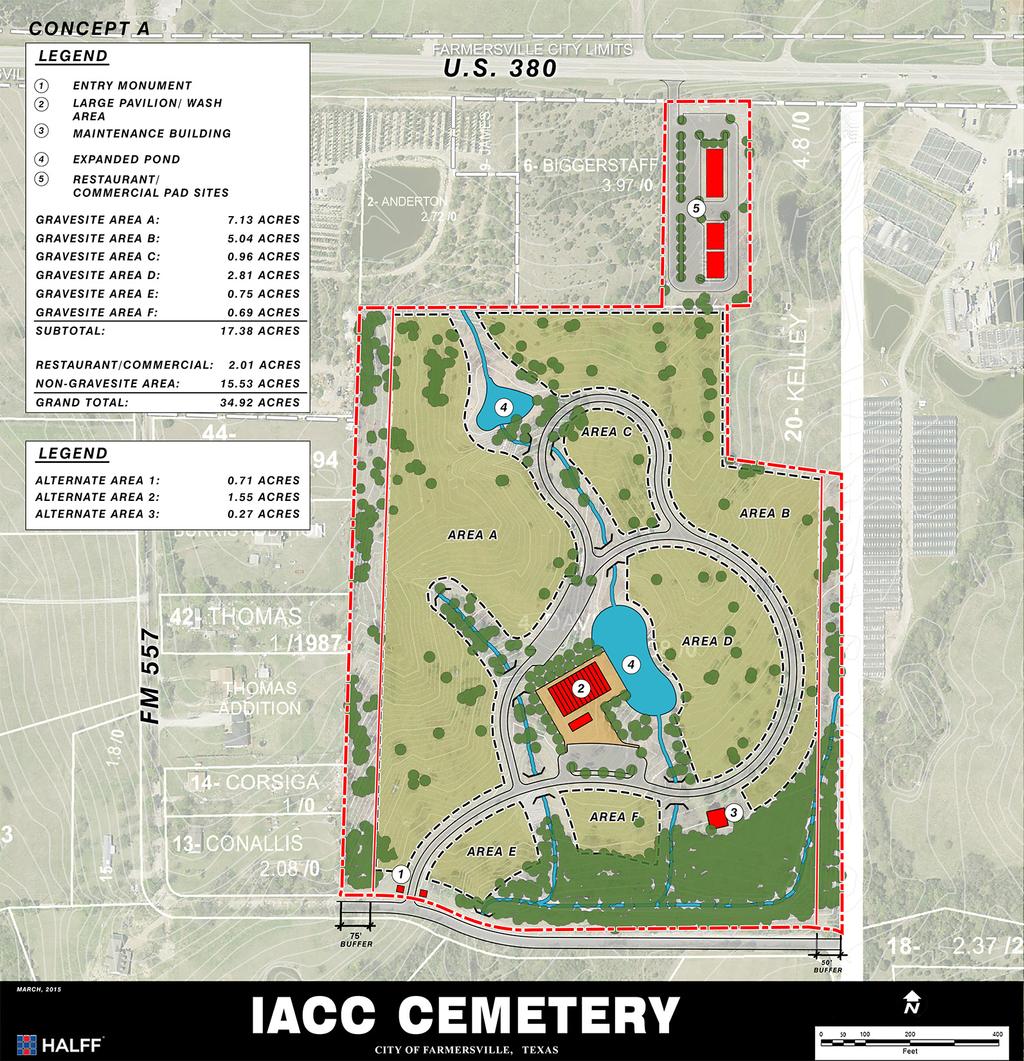
1 TO: Planning and Zoning Commission FROM: Ben White, City Manager DATE: May 28, 2015 SUBJECT: Consider, discuss and act upon a Concept Plan for development of a cemetery situated in the James Innerarity Survey, Abstract #467, Tract 7 and 4 between FM 557 and West Audie Murphy Parkway ACTION: Approve or disapprove Concept Plan as presented. (II A)
2
3
4
5
6 WV MB Owner's Certificate State of Texas} WEST AUDIE MURPHY PARKWAY (VARIABLE RIGHT-OF-WAY) US HIGHWAY 380 EXISTING DRIVEWAY ACCESS County of Collin} Legend of Symbols & Abbreviations NG NATURAL OUND EOC EDGE OF CONCRETE CLF CHAIN LINK FENCE EOA EDGE OF ASPHALT RD ROOF DRAIN UGC UNDEROUND CABLE MONTXDOT ROW TXDOT MON JESSE LEE JAMES, ETUX VOL. 999, PG POINT OF BEGINNING TXDOT MON UGC STATE OF TEXAS INST. No FUTURE DRIVEWAY CONNECTION, TYP FH WV MONTXDOT ROW RCP/ RCP/18 L /2" IRS L UGC MON VAULT PIPE RCP/4X HDWL /2" IRS PIPE VAULT " OAK MAJESTIC TREE TPED WM RCP/ MONNTMWD AIR VALVE MON CITY OF FAMERSVILLE CITY LIMITS UGC MON WDF WDF Whereas Brenda Moreland, is the Owner ofa tract of land situated in Collin County, Texas, situated in the James Innerarity Survey, Abstract NO. 467, and being all of Tract 7 and Tract 4, described in Warranty Deed to Brenda Moreland, as recorded in Instrument No , of the Official Public Records of Collin County, Texas, and being the remainder of a tract of land described in Warranty Deed to Nugent Davis and wife, Gladys Davis, as recorded in Volume 676, Page 811, of the Official Public Records of Collin County, Texas, and being the remainder of First tract of a tract of land described in Deed to Nugent Davis and wife, Gladys H. Davis, as recorded in Volume 627, Page 161, of the Official Public Records of Collin County, Texas, and being more particularly described as follows: WDF WOOD FENCE UGG UNDEROUND GAS OW LINE UGT UNDEROUND TELEPHONE PP POWER POLE SS MH SANITARY SEWER MANHOLE LP LIGHT POLE FH FIRE HYDRANT CO CLEANOUT LID LID WMH WATER MANHOLE WV WATER VALVE GUY GUY WIRE 48" R.C.P. 48" R.C.P. HDG HEDGE WM WATER METER TC TOP OF CURB G GUTTER HYC HICKORY TREE SDMH STORM MANHOLE EB ELECTRIC BOX OT/12 OAK TREE SD MH STORM DRAIN MANHOLE T/12 CREPE MYRTLE TREE CT/12 CEDAR TREE HKT/12 HACKBERRY TREE CONCRETE COL COLUMN CTWD/12 COTTONWOOD TREE ICV IRRIGATION CONTROL VALVE ET/12 ELM TREE DI DROP INLET WT/12 WILLOW TREE BO BUILDING OVERHANG PROJECT SITE TO PRINCETON FM 560 N.T.S. 380 VICINITY MAP HANNA CITY OF FARMERSVILLE, TEAXS TO FARMERSVILLE FM 606 GENERAL NOTES: 1. THE PURPOSE OF THIS PLAT IS TO CREATE TWO LOTS. 2. The basis of bearing is The Texas State Plane Coordinate System, North Central Zone, North American Datum of Coordinates shown are Texas State Plane Coordinate System, North Central Zone, North American Datum of 1983 on Grid Coordinate Values, no scale and no projection. 4. Lot-to-lot drainage is not permitted without Engineering section approval. 5. This property is located within the City of Farmersville E.T.J. (VARIABLE RIGHT-OF-WAY) MONTXDOT GPS2 OLD WIF WIF WIF OLD BURRIS ADDITION 2.0 ACRES VOL.C, PG.745 LOT 1 THOMAS ADDITION LOT 1 AND 2 VOL. P, PG. 440 LOT 2 DAVID ANDERTON VOL. 5156, PG. 343 FONDA STEWART & RONALD L. PRUITT INST. No D.R.C.C.C.T. JOHN THOMAS DOC ZOSIMO P CORSIGA VOL. 2682, PG. 832 BLT REJV3 DALLAS LLC INST. No ' SET PK NAIL FENCE CORNER IRF/12 N 01 25'52" E 560 (VARIABLE RIGHT-OF-WAY) VEGETATION SCREENING VEGETATION SCREENING PROPOSED VEGETATIVE SCREENING N 89 43'19" E ' CITY OF FAMERSVILLE ETJ ,408,322 SQ. FT. 530 LOT Ac PROPOSED CEMETERY EASEMENT NORTH TEXAS MUNICIPAL WATER DISTRICT INST. No ROYA S. KHADEMI INT. No REMAINDER OF VOL. 627, PG NUGENT DAVIS AND GLADYS DAVIS TRACT 7 BRENDA MORELAND INST. No ' SHED BLD BRENDA MORELAND INST. No ' PROPOSED DRIVEWAY ACCESS 1/2" IRON ROD Ac N 01 23'13" E IRF/ ,493,154 SQ. FT. PROPOSED POND TOTAL: 545 N 85 31'01" W REMAINDER OF NUGENT DAVIS AND GLADYS DAVIS ' S 88 56'09" E TRACT OUTDOOR PAVILION VOL. 676, PG ' CONCRETE DRIVE IRF/RR SPIKE S 02 15'01" E ' L L RR SPIKE OLD FENCE 535 RESTROOM/WASH AREA Ac ,832 SQ. FT. REBECCA KELLY INST. No OLD FENCE ' LOT 1 S 84 21'44" E 525 PROPOSED CEMETERY FUTURE COMMERCIAL MAINTENACE BUILDING PROPOSED CEMETERY S 01 44'06" W ' OLD FENCE FUTURE CEMETERY DEVELOPMENT (OUTSIDE DASHED LINE) PHASE I CEMETERY DEVELOPMENT 0 (WITHIN DASHED LINE) EVENS FARM LTD. INST. No FUTURE 4 LANE UNDIVIDED ROADWAY (70' R.O.W.) SCALE IN FEET LINE BEARING DISTANCE L1 S 88 54'50" E 90.71' L2 S 77 36'14" E ' L3 S 00 53'06" W ' L4 N 86 50'06" W 66.45' BEGINNING at a found aluminum disk stamped "TxDot Right-of-Way", being the southwest corner of a tract of land conveyed to State of Texas, as recorded in Instrument No , of the Official Public Records of Collin County, Texas, being in the east line of a tract of land conveyed to Roya S. Khademi, as recorded in Instrument No , of the Official Public Records of Collin County, Texas, and being in the west line of said Tract 7; THENCE along the south line of said Texas tract and over and across said Tract 7, South 88 degrees 54 minutes 50 seconds East, a distance of feet to a set 1/2" Iron rod with yellow cap stamped "SGI RPLS 3664", being a interior point of said Texas tract; THENCE South 77 degrees 36 minutes 14 seconds East, a distance of feet to a set 1/2" Iron rod with yellow cap stamped "SGI RPLS 3664", being the southeast corner of said Texas Tract, and being in the east line of said Tract 7; THENCE departing the south line of said Texas tract and along the east line of said Tract 7 of said Moreland tract, South 00 degrees 53 minutes 06 seconds West, a distance of feet to a found old Fence Post, being the southeast corner of Tract 7, and being a interior corner of a tract of land conveyed to Rebecca Kelley, as recorded in Instrument No , of the Official Public Records of Collin County, Texas; THENCE along the south line of said Tract 7, South 86 degrees 50 minutes 06 seconds East, a distance of feet to a Found Old Fence Post, being in the south line of said Tract 7, and being the most westerly corner of said Kelley tract, and being the most northerly northeast corner of said Tract 4; THENCE departing the south line of said Tract 7 and along a old Fence line, and the most westerly east line of said Tract 4, South 02 degrees 15 minutes 01 seconds East, a distance of feet to a found railroad Spike, being a interior corner of said Tract 4, and the southwest corner of said Kelly tract; THENCE departing the most westerly east line of said Tract 4 and along the most southerly north line of said Tract 4, South 84 degrees 21 minutes 44 seconds East, a distance of feet to a found old post, being the northeast corner of said Tract 4, being the southeast corner of said Kelly tract, and being in the west line of a tract of land conveyed to Evens Farm LTD., as recorded in Instrument No , of the Official Public Records of Collin County, Texas; THENCE departing the most southerly north line of said Tract 4 and along the most easterly east line of said Tract 4, South 01 degrees 44 minutes 06 seconds West, a distance of feet to a found "S" shaped Spike in the abandoned Centerline of Farm to Market Road 577, being the southwest corner of said Evens Farm tract, being the southeast corner of said Tract 4; THENCE departing the southwest corner of said Evens Farm tract and along the south line of said Tract 4, North 85 degrees 31 minutes 01 seconds West, a distance of feet to a set PK nail in the centerline of Farm to Market road 577, being the southeast corner of a tract of land conveyed to BLT REJV3 Dallas LLC., as recorded in Instrument No , of the Official Public Records of Collin County, Texas, and being the southwest corner of said Tract 4; THENCE departing the southwest corner of said Tract 4 and along the west line of said Tract 4 also along a long standing fence, North 01 degrees 25 minutes 52 seconds East, a distance of feet, to a found fence corner, being the northeast corner of said Tract 4, a interior corner of a tract of land conveyed to David Anderton, as recorded in Volume 5156, Page 343, of the Official Public Records of Collin County, Texas; THENCE departing the northwest corner of said Tract 4 and along the most northerly north line of said Tract 4 also along a long standing fence, North 89 degrees 43 minutes 19 seconds East, a distance of feet, to a found 1/2 inch iron rod, being in the most northerly north line of said Tract 4 and the southwest corner of said Tract 7, and being the southeast corner of said Khademi tract; THENCE departing the north line of said Tract 4, and along the west line of said Tract 7 and along a long standing fence, North 01 degrees 23 minutes 13 seconds East, a distance of feet, to the POINT OF BEGINNING and containing 1,492,911 square feet or acres of land, more or less. CONCEPT PLAN ISLAMIC ASSOCIATION OF COLLIN COUNTY ADDITION LOTS 1 AND AC. TRACT AN UNPLATTED TRACT OF LAND IN THE JAMES INNERARITY SURVEY, ABSTRACT No. 467 COLLIN COUNTY, TEXAS OOD STATEMENT: According to Community Map No C0320 J, dated June 2, 2009 of the Federal Emergency Management Agency, National Flood Insurance Program map part of this property is within Flood Zone "X", which is not a special flood hazard area. If this site is not within an identified special flood hazard area, this flood statement does not imply that the property and/or structures thereon will be free from flooding or flood damage. On rare occasions, greater floods can and will occur and flood heights may be increased by man-made or natural causes. This statement shall not create liability on the part of the Surveyor IRS/12 RCP\ (VARIABLE RIGHT-OF-WAY) SIGN IRS/ OWNER BRENDA MORELAND 917 COLCHESTER ST. GARLAND, TX (972) AGGED PIPE/S OLD STAKE "S" SURVEYOR SALCEDO OUP, INC. 400 S. ZANG BLVD., SUITE 1420 DALLAS, TEXAS (214) Texas P.E. F-5482 : Texas PLS Firm License SALCEDO OUP, INC. 400 S. ZANG BLVD., SUITE 1420 DALLAS, TX PHONE: (214) SHEET 1 OF 1
7
1 i12 4( H nnd Fl) (2 F Fxhtht I} Pa:e of
 (2 F Fxhtht I} Pa:e of") 28231 11iB9 Exhibit 621A GIS Approved PROPOSED METES AND BOUNDS PD 621 PROPERTY AND SUBDISTRICT DESCRIPTIONS SUBDISTRICT 1 EXCLUDING Planned Development District (PDD) No. 339 (containing 9,865 square
28231 11iB9 Exhibit 621A GIS Approved PROPOSED METES AND BOUNDS PD 621 PROPERTY AND SUBDISTRICT DESCRIPTIONS SUBDISTRICT 1 EXCLUDING Planned Development District (PDD) No. 339 (containing 9,865 square
Request Applicant Owner Zoning Location Attachments Site and Surrounding Area Direction Surrounding Zoning Surrounding Land Use Access
 Planning & Zoning Commissionn Planning & Development Department September, 0 Preliminary/Final Plat Westwood, Section, Phase Request Applicant Owner Zoning Location Attachments Subdivision of approximately.
TOWN OF SEVERANCE, COLORADO. NOTICE OF PUBLIC HEARINGS FOR A PROJECT Hunters Crossing Annexation & Zoning
 TOWN OF SEVERANCE, COLORADO NOTICE OF PUBLIC HEARINGS FOR A PROJECT Hunters Crossing Annexation & Zoning NOTICE IS HEREBY GIVEN that the Public Hearing required by C.R.S. 31-12-108 before the Severance
CITY OF PORTLAND, TEXAS SERVICE PLAN FOR ANNEXATION AREA
 CITY OF PORTLAND, TEXAS SERVICE PLAN FOR ANNEXATION AREA Location and Acreage Approximately 1,863 acres of land in San Patricio County, located in the ETJ northwest of the existing City Limits. Metes and
Proclaiming Certain Lands as Reservation for the Confederated Tribes of the
 This document is scheduled to be published in the Federal Register on 11/05/2018 and available online at https://federalregister.gov/d/2018-24174, and on govinfo.gov [4337-15] DEPARTMENT OF THE INTERIOR
For Sale on Bids. Open House By Appointment
 For Sale on Bids Written Bid Deadline: Friday, September 7, by 12:00 P.M. Noon 52+/- Acres & Storage Facility Grand Forks, ND Property Location: Conveniently located off Interstate 29 and North Washington
BACKGROUND AND PROJECT DESCRIPTION
 June 7, 2017 Applicant: Murdock Builders Location: Approximately 600 West 1200 North Prepared by: Brian Tucker Public Hearing Item: Yes Zone: A-2, RA-2 ATTACHMENTS 1. Findings for Decision. 2. Resolution
12"CMP DIA. ELEV. PVC CI DI CMP VCP RCP RCAP LRCP LCPP STA. LA LB BM-2 ROW PI POT LF TH PVC
 PLANS FOR X-REFS: FILE PATH: Z:\WEST BRANCH 3682 MAIN STREET SIDEWALK IMPROVEMENTS - PHASE 3\DRAWINGS\_PRODUCTION DRAWINGS\TITLE & INDEX PLOTTED: Thursday, May 26, 216 4:7:42 PM MAIN STREET SIDEWALK PHASE
ATTACHMENT A. Item #1 Minimum Bid: $3, Parcel No Assessed Value: $10,000 Acreage: 0
 ATTACHMENT A Item #1 Minimum Bid: $3,634.59 Parcel No. 0610540500 Assessed Value: $10,000 Acreage: 0 Lots 5 and 6, Block 54, Town of Coulee Dam, Washington, according to the Second Revised Okanogan County
CITY OF PAPILLION PLANNING COMMISSION STAFF REPORT MAY 27, 2015 AGENDA 2015 ANNEXATION MISC
 PLANNING COMMISSION STAFF REPORT MAY 27, 2015 AGENDA 2015 ANNEXATION MISC-15-0005 I. GENERAL INFORMATION A. APPLICANT: City of Papillion 122 East Third St. Papillion, NE 68046 B. LEGAL DESCRIPTION: See
CONGLETON INDUSTRIAL PARK LT 6 EX W 300' & E 350' LT 7 BLK 1, a subdivision of land in the City of Overland Park, Johnson County, Kansas.
 NOTICE OF PUBLIC HEARING CITY PLANNING COMMISSION CITY OF OVERLAND PARK, KANSAS Notice is hereby given that the City Planning Commission of Overland Park, Kansas, will hold a public hearing Monday, July
Summary of Legal Descriptions
 Perimeter Descriptions Bounds Descriptions - perimeter descriptions without a direction of travel. Metes Descriptions - perimeter descriptions with a direction of travel described by a series of measurements.
Planning & Zoning Commission
 Request Applicant Owner Zoning Location Attachments Subdivision of 50.03 acres of previously unplatted property to create one lot for the construction of a K-6 th Grade Education Village for Dickinson
Owatonna Planning Commission Agenda
 Owatonna Planning Commission Agenda Tuesday, September 11, 2018 5:30 PM City Council Chambers Roll Call: Jessop, Meneguzzo, Kain, Meillier, Linders, Steckelberg, Meier 1. Approve minutes of the August
73-2 have been satisfied; and
 RESOLUTION NO. R- 86-104 W'dEREAS, the Board of County Commissioners, as the governing body, pursuant to the authority vested in Chapter 163 and Chapter 125, Florida Statutes, is authorized and empowered
An ordinance changing the zoning classification on the following property:
 Page 150449 2-24-15 2 9 664 An ordinance changing the zoning classification on the following property: BEING part of Lots 5, 6, 10, 11, 13, 14, 15, 16, 17, and 18 in City Block 5/7077; fronting approximately
ORDINANCE NO A municipal setting designation ordinance prohibiting the use of designated groundwater from
 City 1 53 1 2-11-15 ORDNANCE NO. 2 9 6 4 2 A municipal setting designation ordinance prohibiting the use of designated groundwater from beneath property generally located in the Dallas Floodway on the
MILLS COUNTY, IOWA FARMLAND FOR SALE PRICE REDUCED
 MILLS COUNTY, IOWA FARMLAND FOR SALE PRICE REDUCED Owners: Riverdale Farm Corp. Acres: 302.59 Legal Description: Location: Description: See Attached From I-29/Highway 370 exit, 1 ¾ Miles west on Highway
UTILITY REPORT FOR THORNTON SELF STORAGE THORNTON, COLORADO
 UTILITY REPORT FOR THORNTON SELF STORAGE THORNTON, COLORADO Prepared by: Bowman Consulting 63 Park Point Dr. Suite 1 Golden, CO 841 (33)-81-29 June 29, 215 Revised August 14, 215 Revised September 3, 215
C-62 RELATED ACTS. Priv. Acts 1955, Ch. 275, "An Act to redefine the boundaries of the City of Belle Meade... C-63
 C-62 RELATED ACTS Priv. Acts 1955, Ch. 275, "An Act to redefine the boundaries of the City of Belle Meade... C-63 C-63 CHAPTER NO. 275 1 HOUSE BILL NO. 758 (By Davidson Delegation) AN ACT to redefine the
Hydrology Study Report
 Hafeez Consulting www.hafeezconsulting.com Civil/ Structural Engineering, Design & Construction 1451 S. Hacienda St. Anaheim CA 92804 (714) 225-4565 Fax (714)917-2977 engineer@hafeezconsulting.com Hydrology
TOWNSHIP OF SCHUYUULL COUNTY OF SCRUYLMLL RESOLUTIONS ADOPTED 7.9 RESOLUTION
 TOWNSHIP OF SCHUYUULL COUNTY OF SCRUYLMLL RESOLUTIONS ADOPTED 7.9, 1999 RESOLUTION C/9.3, DECLARING ThE INTENT OF THE TOWNSHIP OF SCHUYLKILL THAT THE PORTION OF UMON STREET ADJACENT TO THE PROPERTY OF
STORMWATER REPORT FRITO LAY SUBDIVISION NO. 3
 STORMWATER REPORT FRITO LAY SUBDIVISION NO. 3 May 2018 STORMWATER REPORT I. Subdivision Data a. The parcel is adjacent to the existing Frito Lay property in Topeka; and the subject plat application encompasses
CITY OF PERRIS FLOOD CONTROL MAINTENANCE DISTRICT NO. 1. ANNUAL ENGINEER S REPORT FISCAL YEAR 2015/2016 May 12, 2015
 CITY OF PERRIS FLOOD CONTROL MAINTENANCE DISTRICT NO. 1 ANNUAL ENGINEER S REPORT FISCAL YEAR 2015/2016 May 12, 2015 AGENCY: City of Perris PROJECT: Flood Control Maintenance District No. 1 TO: City Council
C11 EDR - STRONGHOLD BUILDING STORM WATER QUALITY MANAGEMENT PLAN ROBSTOWN, TEXAS, COUNTY ROAD 69 MUNOZ ENGINEERING CIVIL STRUCTURAL MARINE
 RMIII 6/3/7 U I U I TENTION POND REV ISSUED FOR CONSTRUCTION PHONE: 36-946-4848 38 ANDREA LN CORPUS CHRISTI, TX, 7844 TBPE FIRM No. F-4 TENTION DITCH LEGEND PROPOSED STORMWATER / DRAINAGE FLOW DIRECTION
I 34. Applicable Urban Design Priorities Project Should Achieve. elm. main. pryor. crowd. henry. canto. Policy References. Deep Ellum Garage + Office
 Applicable Urban Design Priorities Project Should Achieve Westdale Deep Ellum (UDPRP Reviewed) The Epic (UDPRP Reviewed) elm 42 Deep Ellum (UDPRP Reviewed) pryor r latime lm x malco e us henry R Street
CITY OF PERRIS FLOOD CONTROL MAINTENANCE DISTRICT NO. 1. ANNUAL ENGINEER S REPORT FISCAL YEAR 2011/2012 April 26, 2011
 CITY OF PERRIS FLOOD CONTROL MAINTENANCE DISTRICT NO. 1 ANNUAL ENGINEER S REPORT FISCAL YEAR 2011/2012 April 26, 2011 AGENCY: City of Perris PROJECT: Flood Control Maintenance District No. 1 TO: City Council
OKLAHOMA CORPORATION COMMISSION OIL & GAS CONSERVATION DIVISION P.O. BOX OKLAHOMA CITY, OK (Rule 165:10-3-1) PERMIT TO DRILL
 PERMIT TO DRILL") API NUMBER: 039 Horizontal Hole 22513 Oil & Gas OKLAHOMA CORPORATION COMMISSION OIL & GAS CONSERVATION DIVISION P.O. BOX 52000 OKLAHOMA CITY, OK 73152-2000 (Rule 165:10-3-1) Approval Date: 08/11/2017 Expiration
API NUMBER: 039 Horizontal Hole 22513 Oil & Gas OKLAHOMA CORPORATION COMMISSION OIL & GAS CONSERVATION DIVISION P.O. BOX 52000 OKLAHOMA CITY, OK 73152-2000 (Rule 165:10-3-1) Approval Date: 08/11/2017 Expiration
SURVEYING AND MAPPING, INC. COORDINATE DATA SHEET JOB: CITY OF DECATUR CLIENT: CITY OF DECATUR SAM JOB#:
 13 March 2001 SURVEYING AND MAPPING, INC. COORDINATE DATA SHEET JOB: CITY OF DECATUR CLIENT: CITY OF DECATUR SAM JOB#: 21038-20 HORIZONTAL DATUM: NAD-83 GEODETIC VERTICAL STATION ID LATITUDE LONGITUDE
UA SURVEY CONTROL MONUMENT UA #1 CLEVELAND STREET GARLAND AVENUE. Northing / Easting / Elevation
 #1 Northing 640586.689 / Easting 669419.281 / Elevation 1443.178 Center of bronze cap with UA seal. Located in sidewalk approx. 10 W of curb on Garland Ave. Approx. 24.5 SE of traffic signal post. UA #1
Eastlake Assited Living & Memory Care
 UTILITY REPORT FOR Eastlake Assited Living & Memory Care 1 st Submittal January 23, 2016 2 nd Submittal March 04, 2016 June 7, 2016 Final Submittal August 08, 2016 Prepared for: 3301 E. 120 th Ave, LLC.
Chapter 1 Homework - Elements of Real Estate Law
 Chapter 1 Homework - Elements of Real Estate Law The following questions are a small example of what you might expect to see on the Real Estate Law portion of the Cadastral Mapping exam. First try answering
NCEES FS Practice Exam
 NCEES FS Practice Exam Terrametra Resources Lynn Patten 1. One corner of a 60-ft. 120-ft. lot, otherwise rectangular, is a curve with a radius of 20 ft. and a central angle of 90. The area (ft. 2 ) of
REQUEST FOR PROPOSALS CLOSING DATE:
 Request for Proposals 110 Westlake Drive City of West Lake Hills 110 Westlake Drive REQUEST FOR PROPOSALS CLOSING DATE: Tuesday, October 23, 2018 City of West Lake Hills Request for Proposals 1 I. INTRODUCTION
Legislation Passed June 9, 2015
 Legislation Passed June, 0 The Tacoma City Council, at its regular City Council meeting of June, 0, adopted the following resolutions and/or ordinances. The summary of the contents of said resolutions
BRANDON LAKES AVENUE PRE AND POST CONDITIONS DRAINAGE REPORT
 BRANDON LAKES AVENUE PRE AND POST CONDITIONS DRAINAGE REPORT Hillsborough County Public Works County Center, 22nd Floor 601 E. Kennedy Blvd. Tampa, FL 33602 BRANDON LAKES AVENUE DRAINAGE IMPROVEMENTS Capital
NOTICE OF PUBLIC HEARING GREEN MEADOWS ANNEXATION (Formally Known as Rude Annexation) (File No. A-17-04)
 (File No. A-17-04)") NOTICE OF PUBLIC HEARING GREEN MEADOWS ANNEXATION (Formally Known as Rude Annexation) (File No. A-17-04) NOTICE IS HEREBY GIVEN that the City Council of Post Falls will hold a public hearing at City Hall,
NOTICE OF PUBLIC HEARING GREEN MEADOWS ANNEXATION (Formally Known as Rude Annexation) (File No. A-17-04) NOTICE IS HEREBY GIVEN that the City Council of Post Falls will hold a public hearing at City Hall,
3301 East 120 th Avenue Assited Living & Memory Care
 UTILITY REPORT FOR 3301 East 120 th Avenue Assited Living & Memory Care 1 st Submittal January 23, 2016 2 nd Submittal March 04, 2016 Prepared for: 3301 E. 120 th Ave, LLC. 8200 E. Maplewood Ave., Suite
VILLAGE OF ORLAND PARK
 14700 Ravinia Avenue Orland Park, IL 60462 www.orland-park.il.us Ordinance No: File Number: 2013-0373 AN ORDINANCE ESTABLISHING SPECIAL SERVICE AREA NUMBER 3 STATE OF ILLINOIS, COUNTIES OF COOK AND WILL
TOWN OF GARDEN CITY 150 SOUTH STREET BEACH ACCESS PARKING
 TOWN OF GARDEN CITY 150 SOUTH STREET BEACH ACCESS PARKING GARDEN CITY, UTAH Sheet Number Sheet List Table Sheet Title PROJECT NO. 57-14-017:003 February 20, 2015 NOTICE AND DISCLAIMER The plans and/or
Preliminary Hydraulic Report
 Tarrant County, Texas Preliminary Hydraulic Report Prepared for: Texas Department of Transportation Fort Worth District Prepared by: AECOM Corporation Scott C. Williams, P.E. No. 101334, Date 2009 This
WHEREAS, a zoning district map and legaldescription for the subject property are provided in Ordinance Exhibits A and B, respectively; and
 ORDINANCE NO S.907. AN ORDINANCE AMENDING ORDINANCE NO 4441, WHICH ADOPTED THE CITY OF ALBANY ZONING MAP, BY AMENDING THE ALBANY ZONING MAP AND ADOPTING FINDINGS FOR UNADDRESSED PARCELS, LINN COUNTY ASSESSOR'
NGS Data Sheets for Rifle HARN Points
 NGS Data Sheets for Rifle HARN Points DATABASE = Sybase,PROGRAM = datasheet, VERSION = 6.98 1 National Geodetic Survey, Retrieval Date = MARCH 17, 2004 ***********************************************************************
BEFORE THE BOARD OF COUNTY COMMISSIONERS OF LANE COUNTY, OREGON
 BEFORE THE BOARD OF COUNTY COMMISSIONERS OF LANE COUNTY, OREGON ORDER NO. 18-05-22-06 IN THE MATTER OF SURRENDER OF A PORTION OF COAST GUARD STATION ROAD (COUNTY ROAD NUMBER 65) AND A PORTION OF S. HARBOR
Villages at Riverdale Thornton, CO
 FINAL UTILITY REPORT Villages at Riverdale Thornton, CO October 14, 216 Revised: March 29, 217 JN: 1539 Prepared for: PCS Group, Inc. 11 16 th Street #3 B-18 Denver, CO 8265 P: 33.531.495 Prepared by:
VILLAGE OF ORLAND PARK
 14700 Ravinia Avenue Orland Park, IL 60462 www.orland-park.il.us Ordinance No: File Number: 2013-0239 AN ORDINANCE PROPOSING THE ESTABLISHMENT OF SPECIAL SERVICE AREA NUMBER 2 IN THE, AND PROVIDING FOR
DE PUBLIC SERVICE COMPANY OF NEW HAMPSHIRE
 DE 05-142 PUBLIC SERVICE COMPANY OF NEW HAMPSHIRE Petition for License to Construct and Maintain Electric Lines Over and Across the Public Waters of the Nashua River in the City of Nashua, New Hampshire
WHITEHEAD 30 (10) (570) (30) (10) & TRACY MILLER.
 (570) (30) (10) & TRACY MILLER.") BEGINNING at a point in the center of Pennsylvania State Highway Route No. 414, said point located on the boundary between the lands herein described and lands now or formerly of Carman Tartaglia; thence
BEGINNING at a point in the center of Pennsylvania State Highway Route No. 414, said point located on the boundary between the lands herein described and lands now or formerly of Carman Tartaglia; thence
APPENDIX B DRAINAGE REPORT
 APPENDIX B DRAINAGE REPORT B-1 South Lamar Blvd. Transportation Corridor Study Drainage Report Prepared for: City of Austin and HDR, Inc. Prepared by: and Services, Inc. Final 07-09-2015 Michael C. Meriwether,
STORM DRAINAGE IMPROVEMENT PETITION TERRACE AND METCALF CITY OF OVERLAND PARK JOHNSON COUNTY, KANSAS
 STORM DRAINAGE IMPROVEMENT PETITION STANLEY STORM DRAINAGE IMPROVEMENTS, 151sT TERRACE AND METCALF CITY OF OVERLAND PARK JOHNSON COUNTY, KANSAS TO: THE GOVERNING BODY OF THE CITY OF OVERLAND PARK, KANSAS
ALLEGHENY COUNTY AIRPORT AUTHORITY PITTSBURGH INTERNATIONAL AIRPORT
 ALLEGHENY COUNTY AIRPORT AUTHORITY PITTSBURGH INTERNATIONAL AIRPORT SURVEYING STANDARDS AND RECOVERY NOTES Prepared by: BSC Group, Inc. 15 Elkins Street Boston, Massachusetts 02127 August 2003 Survey Standards
FINAL UTILITY REPORT Creekside Thornton, CO
 FINAL UTILITY REPORT Creekside Thornton, CO March 4, 216 Revised: June 27, 216 JN: 1539 Prepared for: HW Sodbusters, LLC 2733 E. Parleys Way, Suite 3 Salt Lake City, UT 8419 P: 81.485.777 Prepared by:
HILLSIDE DEVELOPMENT APPLICATION CHECKLIST C (Proposal to create lots as of 9/12/2007)
") HILLSIDE DEVELOPMENT APPLICATION CHECKLIST C (Proposal to create lots as of 9/12/2007) Applicability for lands to be partitioned and/or divided, without ultimate building construction proposed. Submittal
HILLSIDE DEVELOPMENT APPLICATION CHECKLIST C (Proposal to create lots as of 9/12/2007) Applicability for lands to be partitioned and/or divided, without ultimate building construction proposed. Submittal
PRELIMINARY ENGINEERING REPORT FOR SANITARY SEWER COLLECTION SYSTEM OSKALOOSA, IOWA 2017
 PRELIMINARY ENGINEERING REPORT FOR SANITARY SEWER COLLECTION SYSTEM OSKALOOSA, IOWA 2017 PRELIMINARY ENGINEERING REPORT FOR SANITARY SEWER COLLECTION SYSTEM OSKALOOSA, IOWA 2017 I hereby certify that this
Analysis of Hydraulic Impacts on the Schuylkill River
 Analysis of Hydraulic Impacts on the Schuylkill River Manayunk Sewer Basin Construction Project and the Venice Island Recreation Center Reconstruction Project Venice Island, Manayunk, Philadelphia, PA
BUILDING AND SAFETY FEE SCHEDULE (Effective July1, 2013)
") BUILDING AND SAFETY DIVISION TELEPHONE (949) 724-6300 BUILDING AND SAFETY FEE SCHEDULE (Effective July1, 2013) Payment: When a plan is required by the Administrative Authority to be submitted, a plan check
BUILDING AND SAFETY DIVISION TELEPHONE (949) 724-6300 BUILDING AND SAFETY FEE SCHEDULE (Effective July1, 2013) Payment: When a plan is required by the Administrative Authority to be submitted, a plan check
WATER MANAGEMENT REPORT FOR PAGE ESTATES
 WATER MANAGEMENT REPORT FOR PAGE ESTATES SLB Consulting of SW Florida, LLC PO Box 2826 Bonita Springs, FL. 34133 Phone: 239-948-9566 sandra@slbconsult.com C.O.A. # 25395 September 1, 2014 Sandra L. Bottcher
LAKEHAYEN UTILITY DISTRICT King County, Washington. Resolution No
 LAKEHAYEN UTILITY DISTRICT King County, Washington Resolution No. 2014-1242 A Resolution of the Board of Commissioners of the Lakehaven Utility District, King County, Washington, approving the establishment
AN ARCHAEOLOGICAL SURVEY FOR THE EASTHAM STATE PRISON FARM UNIT PROJECT IN HOUSTON COUNTY TEXAS
 AN ARCHAEOLOGICAL SURVEY FOR THE EASTHAM STATE PRISON FARM UNIT PROJECT IN HOUSTON COUNTY TEXAS Antiquities Permit 5693 By William E. Moore and Edward P. Baxter Brazos Valley Research Associates Contract
MAP, PLAN AND REPORT FOR THE PROPOSED TOWNS OF VARICK AND ROMULUS WATER DISTRICT (NYS ROUTE 89) TOWNS OF ROMULUS & VARICK SENECA COUNTY, NEW YORK
 TOWNS OF ROMULUS & VARICK SENECA COUNTY, NEW YORK") MAP, PLAN AND REPORT OR THE PROPOSED TOWNS O VARICK AND ROMULUS WATER DISTRICT (NYS ROUTE 8) TOWNS O ROMULUS & VARICK SENECA COUNTY, NEW YORK Prepared or: TOWN O ROMULUS TOWN BOARD 45 Prospect St., PO
MAP, PLAN AND REPORT OR THE PROPOSED TOWNS O VARICK AND ROMULUS WATER DISTRICT (NYS ROUTE 8) TOWNS O ROMULUS & VARICK SENECA COUNTY, NEW YORK Prepared or: TOWN O ROMULUS TOWN BOARD 45 Prospect St., PO
Lake Worth Lagoon Hydrographic Survey Report
 C-51 Canal Sediment Trap Lake Worth Lagoon Hydrographic Survey Report July 11, 2013 South Florida Water Management District 3301 Gun Club Road West Palm Beach, Florida 33406 Table of Contents Background...
MINUTES OF THE BOARD OF PUBLIC WORKS MEETING HELD AT GREENFIELD CITY HALL, COMMON COUNCIL CHAMBERS, ROOM 100, ON TUESDAY, MARCH 27, 2018 AT 6:30 P.M.
 MINUTES OF THE BOARD OF PUBLIC WORKS MEETING HELD AT GREENFIELD CITY HALL, COMMON COUNCIL CHAMBERS, ROOM 100, ON TUESDAY, MARCH 27, 2018 AT 6:30 P.M. 1. Ald. Lubotsky called the meeting to order at 6:33
SOURCE: NAVD88 (Computed using GEOID12B)
") Shared Solution https://www.ngs.noaa.gov/opus/getdatasheet.jsp?pid=... 1 of 1 10/2/2018, 2:52 PM Shared Solution PID: Designation: NYKT R1 Stamping: NYKT R1 2005 Stability: May hold commonly subject to
Shared Solution https://www.ngs.noaa.gov/opus/getdatasheet.jsp?pid=... 1 of 1 10/2/2018, 2:52 PM Shared Solution PID: Designation: NYKT R1 Stamping: NYKT R1 2005 Stability: May hold commonly subject to
City of Thornton Attn: Tim Semones Development Engineeering 9500 Civic Center Dr. Thornton, CO 80229
 Development Engineering Land Surveying Construction Administration District Services October 20, 2017 City of Thornton Attn: Tim Semones Development Engineeering 9500 Civic Center Dr. Thornton, CO 80229
Frequently Asked Questions about MnDOT s Railroad Map Conversion Project
 Frequently Asked Questions about MnDOT s Railroad Map Conversion Project What were the main objectives of the project? What are the results and end products? What can these railroad maps be used for? Who
SITE SUMMARY REPORT Candor Dump NONCD Montgomery County
 SITE SUMMARY REPORT Candor Dump NONCD 0000433 Montgomery County Senate Bill 1492 State of North Carolina State Contract N06009S Schnabel Project No. 06210002.23 February 23, 2010 Prepared for: North Carolina
February 27, 2013
 COUNCIL CHAMBER 10421 Februry 27, 201 WHEREAS, the City of Dlls owns trcts of lnd which re used for Lke Ry Hubbrd; nd WHEREAS, the City of Rowlett hs requested dringe esement with temporry construction
UPPER COSUMNES RIVER FLOOD MAPPING
 UPPER COSUMNES RIVER FLOOD MAPPING DRAFT BASIC DATA NARRATIVE FLOOD INSURANCE STUDY SACRAMENTO COUTY, CALIFORNIA Community No. 060262 November 2008 Prepared By: CIVIL ENGINEERING SOLUTIONS, INC. 1325 Howe
CHAPTER 5 DOWNTOWN DEVELOPMENT AUTHORITY
 CHAPTER 5 DOWNTOWN DEVELOPMENT AUTHORITY Sec. 5-1. Purposes. Sec. 5-2. Definitions. Sec. 5-3. Determination of Necessity. Sec. 5-4. Establishment; Title. Sec. 5-5. Ordinance approving development plan
REZONING GUIDE. Zone Map Amendment (Rezoning) - Application. Rezoning Application Page 1 of 3. Return completed form to
 - Application. Rezoning Application Page 1 of 3. Return completed form to") Zone Map Amendment (Rezoning) - Application COMMUNITY PLANNING & DEVELOPMENT REZONING GUIDE Rezoning Application Page 1 of 3 PROPERTY OWNER INFORMATION* CHECK IF POINT OF CONTACT FOR APPLICATION Property
Zone Map Amendment (Rezoning) - Application COMMUNITY PLANNING & DEVELOPMENT REZONING GUIDE Rezoning Application Page 1 of 3 PROPERTY OWNER INFORMATION* CHECK IF POINT OF CONTACT FOR APPLICATION Property
CITY OF CAPE CORAL STORMWATER MASTER PLAN PHASE II - PART 1 BASINS 4, 10, & 14 SUB-BASIN DRAINAGE IMPROVEMENTS HYDRAULIC ANALYSIS SUMMARY
 CITY OF CAPE CORAL STORMWATER MASTER PLAN PHASE II - PART 1 BASINS 4, 10, & 14 SUB-BASIN DRAINAGE IMPROVEMENTS HYDRAULIC ANALYSIS SUMMARY Cape Coral, FL Prepared for: The City of Cape Coral Public Works
STREUVER FIDELCO CAPPELLI, LLC YONKERS DOWNTOWN DEVELOPMENT PHASE 1. DRAFT ENVIRONMENTAL IMPACT STATEMENT For: PALISADES POINT
 STREUVER FIDELCO CAPPELLI, LLC YONKERS DOWNTOWN DEVELOPMENT PHASE 1 DRAFT ENVIRONMENTAL IMPACT STATEMENT For: PALISADES POINT Prepared by: PAULUS, SOKOLOWSKI & SARTOR STORMWATER MANAGEMENT 1. Methodology
OKLAHOMA CORPORATION COMMISSION OIL & GAS CONSERVATION DIVISION P.O. BOX OKLAHOMA CITY, OK (Rule 165:10-3-1) PERMIT TO DRILL
 PERMIT TO DRILL") API NUMBER: 039 Horizontal Hole 22504 Oil & Gas OKLAHOMA CORPORATION COMMISSION OIL & GAS CONSERVATION DIVISION P.O. BOX 52000 OKLAHOMA CITY, OK 73152-2000 (Rule 165:10-3-1) Approval Date: 06/05/2017 Expiration
API NUMBER: 039 Horizontal Hole 22504 Oil & Gas OKLAHOMA CORPORATION COMMISSION OIL & GAS CONSERVATION DIVISION P.O. BOX 52000 OKLAHOMA CITY, OK 73152-2000 (Rule 165:10-3-1) Approval Date: 06/05/2017 Expiration
5J Minimum Technical Standards: Definitions. As used in this chapter, the following terms have the following meanings: (1) Benchmark: a
 Benchmark: a") 5J-17.050 Minimum Technical Standards: Definitions. As used in this chapter, the following terms have the following meanings: (1) Benchmark: a relatively permanent material object, natural or artificial,
5J-17.050 Minimum Technical Standards: Definitions. As used in this chapter, the following terms have the following meanings: (1) Benchmark: a relatively permanent material object, natural or artificial,
FOR LEASE ±1,800 SF OUTPARCEL NEW CONSTRUCTION, SINGLE TENANT
 FOR LEASE ±1,800 SF OUTPARCEL NEW CONSTRUCTION, SINGLE TENANT DEERFIELD BEACH FL 33441 ROXANNE REGISTER Vice President of Leasing & Sales RoxanneRegister@dkatz.com (561) 869-4346 HIGHLIGHTS Retail only
Sacramento County Recorder Craig A, Kramer, Clerk/Recorder BOOK PAGE 0708
 I\~ nt"lr'iiaaci\it,.,""'", L...L.. LJ,-/VVIVIL.../Y I Government Code 27383 Oi=r()onlll.ll'::: Oi=()1 Il::CTcn cv I '\,L-"",-,' '-LJII'\,J I ''-\"a(vl..v I L..LJ U r AND WHEN RECORDED RETURN TO: Office
VIKING INSPECTION PROPERTY 4921 U.S. Hwy. 85, Williston, ND 58801
 SALE PRICE: $799,000 LOT SIZE: +/-2.49 Acres BUILDING SIZE: +/-3,800 SF DRIVE-IN DOORS 2 CEILING HEIGHT: 16' YEAR BUILT: 2007 ZONING: Commercial PROPERTY OVERVIEW Highly visible, hard-to-find small shop/office/apartment
Sewer Lateral Mapping: An Automated Approach
 Sewer Lateral Mapping: An Automated Approach MSGIC 2016 Fall Quarterly Meeting David Thaler, GISP david.thaler@ebaengineering.com EBA Engineering, Inc. 6100 Chevy Chase Drive Suite 200 Laurel, MD 20707-2917
2. That the designated areas consists of approximately acres, the population in the subject area is zero, and the land use type is industrial.
 Joint Resolution City of Lewiston Minnesota Resolution 2016-16 Utica Township Resolution 6A In the matter of the Orderly Annexation Between the City of Lewiston and Utica Township Pursuant to Minnesota
Winning Farm of Winchester
 Winning Farm of Winchester Planning Board Presentation Winning Farm of Winchester 12.9 acres of undeveloped forest on the former Winning Farm site Located north of Thornberry Road in the northwestern corner
Mock Trial. Harper v. Sunshower Resort. Murfreesboro, Tennessee Saturday March 10, 2018
 Mock Trial Harper v. Sunshower Resort Murfreesboro, Tennessee Saturday March 10, 2018 The Harpers had Peyton Mann perform a survey to prepare for construction of a new house on their lakefront property.
COLORING PAGES. Follow Raindy the Raindrop as he travels from your house out to sea.
 COLORING PAGES www.hcfcd.org Follow Raindy the Raindrop as he travels from your house out to sea. Raindy the Raindrop falls from the sky and lands on your house or in your neighborhood. Once he s on the
Franklin County Engineer's Office - Highway Design Dublin Road And Fishinger Road Improvements Rebid Bid Tabulation
 2/20/2015 Page 1 of 16 Strawser Paving Co., Inc. Double Z Construction Co Decker Construction Company Shelly & Sands, Inc. 1595 Frank Road 2550 Harrison Road 3040 McKinley Avenue P.O.Box 2469 Columbus,
PUBLIC UTILITY COMMISSION OF TEXAS DOCKET NO
 Application of CenterPoint Energy Houston Electric, LLC for a Certificate of Convenience and Necessity for a Proposed 138 kv Transmission Line within Harris County, Texas PUBLIC UTILITY COMMISSION OF TEXAS
TOWN OF WESTLAKE GPS CONTROL MONUMENTS 1-10
 GPS CONTROL MONUMENTS 1-1 GPS MONUMENT NO. 1 September 22, 1999 NAO 1983 (H.A.R.N. 1993) POSTON Latitude: Longitude: 32 58' 16.59982" N 97 1' 42.52797" W TEXAS GRD COORDNATES - North Central Zone (422)
CITY OF FORT COLLINS MEMORANDUM
 CITY OF FORT COLLINS MEMORANDUM DATE: NOVEMBER 2013 TO: FROM: RE: INTERESTED PARTIES NEEDING VERTICAL CONTROL IN THE CITY OF FORT COLLINS JOHN VON NIEDA PLS, CITY SURVEYOR UPDATED CITY OF FORT COLLINS
Mr. Michael Malone CPS Energy 145 Navarro Street San Antonio, Texas Project No
 January 17, 2018 Mr. Michael Malone 145 Navarro Street San Antonio, Texas 78205 Project No. 0337367 Environmental Resources Management CityCentre Four 840 West Sam Houston Pkwy N. Suite 600 Houston, Texas
2267 N o r t h 1500 W C l i n t o n U T 84015
 P l a n n i n g C o m m i s s i o n M e m b e r s C h a i r J a c o b B r i g g s V i c e C h a i r G a r y T y l e r T o n y T h o m p s o n J o l e n e C r e s s a l l A n d y H a l e D e r e c k B a
D. B. G R A Y E N G I N E E R I N G I N C.
 STORMWATER MANAGEMENT REPORT 948 Hunt lub Road Ottawa, Ontario Report No. 12020-SWM August 27, 2012 Revised April 21, 2014 Revised December 9, 2014 Revised April 14, 2015 D. B. G R A Y E N G I N E E R
DRAINAGE REPORT FOR THORNTON SELF STORAGE THORNTON, COLORADO
 DRAINAGE REPORT FOR THORNTON SELF STORAGE THORNTON, COLORADO Prepared by: Bowman Consulting 603 Park Point Dr. Suite 100 Golden, CO 80401 (303)-801-2900 June 29, 2015 Revised August 14, 2015 CERTIFICATE
[LLAZC X.L EA0000; AZ SRP ] Notice of Temporary Closures: Selected Public Lands in La Paz County, AZ
![[LLAZC X.L EA0000; AZ SRP ] Notice of Temporary Closures: Selected Public Lands in La Paz County, AZ](/thumbs/89/100188672.jpg "[LLAZC X.L EA0000; AZ SRP ] Notice of Temporary Closures: Selected Public Lands in La Paz County, AZ") This document is scheduled to be published in the Federal Register on 12/29/2017 and available online at https://federalregister.gov/d/2017-28217, and on FDsys.gov 4310-32 DEPARTMENT OF THE INTERIOR Bureau
This document is scheduled to be published in the Federal Register on 12/29/2017 and available online at https://federalregister.gov/d/2017-28217, and on FDsys.gov 4310-32 DEPARTMENT OF THE INTERIOR Bureau
Public Land Survey System Knowledge Remains an Important Skill
 By Douglas S. Helmke, P.G., Water Rights / Source Water Specialist Public Land Survey System Knowledge Remains an Important Skill In our new world of global positioning system (GPS) navigation, with digital
Planning. plat. RSF-7-PUD. 1. Proposed 2. Aerial Map. Area. Land Use. Direction North. Surrounding PS-PUD
 lanning Zoning Commissionn reliminy / Final lat Magnolia Creek, Section, hase II lanning Development Deptment November 2, 2055 equest pplicant Owner Zoning Location ttachments Site and Surrounding rea
THE PARKE AT OCEAN PINES HOME OWNERS ASSOCIATION, INC. Policy Resolution Snow Removal Policy
 THE PARKE AT OCEAN PINES HOME OWNERS ASSOCIATION, INC. Policy Resolution 20141029 Snow Removal Policy THIS POLICY RESOLUTION 20141029, Snow Removal Policy is made, effective as of October 29, 2014 by THE
STREET LIGHTING AUSTIN ENERGY ILLUMINATION DEPARTMENT
 STREET LIGHTING AUSTIN ENERGY ILLUMINATION DEPARTMENT http://www.austinenergy.com/ Physical Address: 4411 Meinardus Drive Austin, Texas 78744 Hours of Operation: Monday Friday 6am to 3pm Key Contact: Joyce
TREASURE COAST REGIONAL PLANNING COUNCIL M E M O R A N D U M. To: Council Members AGENDA ITEM 4B10
 TREASURE COAST REGIONAL PLANNING COUNCIL M E M O R A N D U M To: Council Members AGENDA ITEM 4B10 From: Date: Subject: Staff December 14, 2018 Council Meeting Local Government Comprehensive Plan Review
BEFORE THE BOARD OF COUNTY COMMISSIONERS OF LANE COUNTY, OREGON
 BEFORE THE BOARD OF COUNTY COMMISSIONERS OF LANE COUNTY, OREGON ORDER NO. 18-04-10-06 IN THE MATTER OF SETTING A PUBLIC HEARING FOR THE PROPOSED SURRENDER OF A PORTION OF COAST GUARD STATION ROAD (COUNTY
Wyoming State Operations Center
 Wyoming State Operations Center Updated Situation Report, Bordeaux Tornado site 14: 36 hrs 8 June 2012 Wyoming Office of Homeland Security (WOHS) arrived at the incident command post at the corner of Olson
City of Saginaw Right of Way Division Snow and Ice Removal Policy January 18, 2016
 Snow and Ice Removal Policy January 18, 2016 It is the policy of the to provide snowplowing and ice removal services in order to: Provide safe traveling conditions for motorists and pedestrians Assist
State Of the City Update CITY OF MAGNOLIA MAY 2018
 State Of the City Update CITY OF MAGNOLIA MAY 2018 FM1488- FM149 Flyover This image cannot currently be displayed. Magnolia High School State of the City Roads FM 1488 /FM 149 Railroad Flyover Under Construction