Instrument Ground School Analyzing Weather Data
|
|
|
- Isabella Bryan
- 5 years ago
- Views:
Transcription
1 Analyzing Weather Data


2 METEOROLOGY PRINTED REPORTS & FORECASTS Getting Weather Reports and Forecasts BY TELEPHONE TALK TO A HUMAN BEING WX-BRIEF Flight Service INTERNET
3 METEOROLOGY PRINTED REPORTS & FORECASTS METAR (Aviation Route Information Report) Hourly report of weather conditions at the specific reporting station. WHY: NEED TO KNOW WHAT TYPE OF WEATHER IS AT DEPARTURE, DESTINATION AND ALONG ROUTE OF FLIGHT (SHOULD WE NEED TO DIVERT TO AN DESTINATION). FORMAT

4 METEOROLOGY PRINTED REPORTS & FORECASTS METAR (Aviation Route Information Report) Types: standard METAR or SPECI for special notification (change) Identifier (USA always begin with letter K Date/Time: DDHHMM (Day#, ITC Zulu Time HHMM ending Z Modifier: none=manual input, or AUTO (check remarks A01/A02 or COR meaning automated facility with no remarks. Wind: XXX(direction) YY (speed) G=GUST TO ZZ=speed minimum 5 digits (1 st 3 direction, next 2 speed) end KTS. samples
 Runway Visual Range (how far can a pilot see down a runway) giving as Runway / feet of visibility above is Runway 36 Left visibility 2400 ft.")
5 METEOROLOGY PRINTED REPORTS & FORECASTS METAR (Aviation Route Information Report)She WIND INFORMATION Prevailing Visibility in Statue Miles. If preceded by P (i.e., P2SM) it means greater than (P2SM = visibility greater than 2 stature miles). M preceding visibility is translated less than. (i.e., M2SM = less than 2 SM) Runway Visual Range (how far can a pilot see down a runway) giving as Runway / feet of visibility above is Runway 36 Left visibility 2400 ft. if given as R36L/2400V3600FT it means 2 measures were taken with the lowest visibility at 2,400 ft and the greatest visibility at 3,600 ft

6 METEOROLOGY METAR (Aviation Route Information Report) Weather: Describes conditions and cloud coverage. These codes are the most complex and require some study See METAR TAF ABBREVIATIONS ON CD (25 pgs)
 0-1/4 = FEW 3/8-1/2 = SCT 5/8-7/8 = BKN >50% coverage = ceiling OVERCAST = OVC Type (CB) Height (AGL): add 2 zeros Barometric")
 Dew point (F) ) / 4.")
7 METEOROLOGY PRINTED REPORTS & FORECASTS METAR (Aviation Route Information Report) VISIBILITY AND HEIGHT INFORMATION CLEAR (SKC OR CLR) 0-1/4 = FEW 3/8-1/2 = SCT 5/8-7/8 = BKN >50% coverage = ceiling OVERCAST = OVC Type (CB) Height (AGL): add 2 zeros Barometric Pressure preceded with A WHY SHOULD WE CARE ABOUT THE DEW POINT? FOG & PREDICT CEILINGS Calculation for expected cloud base AGL = ((Temp (F) Dew point (F) ) / 4.4) x 1000 With temp/dp spread of 20/18, we can expect cloud bases as low as (2/4.4x1000) 455 ft AGL

8 METEOROLOGY PRINTED REPORTS & FORECASTS METAR (Aviation Route Information Report) REMARKS HAVE GREAT VARIETY AND TAKE PRACTICE TO INTERPRET AND MASTER.. BE PATIENT
9 METAR Oddities: not easily recognized Peak Wind (PK_WND) Wind Shift (WSHFT_time) BINOVC (Breaks in Overcast) BINOVC denotes a few, small clear patches in the overcast sky Tower or Surface Visibility (TWR_VIS SFC_VIS) CIG (Ceiling=Lowest BKN/OVC layer or height of VV) V (Variable) i.e. BKN V SCT, VIS 2V3 [2 variable 3 miles], CIG 025V030 [2500 ft-3000ft]) Lightning (Frequency_LTG-type) CG: Cloud to ground IC: Intracloud CC: Cloud to Cloud CA: Cloud to Air OCNL: Occasional FRQ: Frequent CONS: Continuous Beginning/Ending of Thunderstorms/Rain/Snow (TSB, SNE, RAB, etc) Thunderstorm Location (TS_LOC_(MOV_DIR) LOC=Location (N, NE, S, VC, OHD [Overhead], ALQDS [All Quadrants]) DIR=Direction (N, NE, S, etc) Hailstone Size (GR_[size]) Virga (VIRGA_[ DIR]) Cumulonimbus or Cumulonimbus Mammatus (CB or CBMAM_LOC_(MOV_DIR). Towering cumulus (TCU_[DIR]) Altocumulus castellanus (ACC_[DIR]) Standing lenticular or Rotor clouds (CLD_[DIR]) Pressure Rising or Falling Rapidly (PRESRR/PRESFR) Sea-Level Pressure (SLP###) Aircraft Mishap (ACFT_MSHP) Snow Increasing Rapidly (SNINCR_amount this hour/total)
10 Hourly Precipitation Amount (P####). 3- and 6-Hour Precipitation Amount (6####) 24-Hour Precipitation Amount (7####). Snow Depth on Ground (4/###) Water Equivalent of Snow on Ground (9####) Hourly Temperature and Dewpoint (Tsn###sn###) T=Temp sn=type (0=above zero celcius, 1=below zero celcius) ###=celcius temperature to nearest tenth of a degree 6-Hourly Maximum Temperature (1sn###) 6-Hourly Minimum Temperature (2sn###) 24-Hour Maximum and Minimum Temperature (4sn######) First three numbers=maximum temp to nearest tenth of a degree celcius Last three numbers=mimimum temp to nearest tenth of a degree celcius -Hourly Pressure Tendency (5a###)--see table below for a (type) Primary Requirement Description Code Figure Increasing, then decreasing. 0 Atmospheric pressure now higher than 3 hours ago. Atmospheric pressure now same as 3 hours ago. Atmospheric pressure now lower than 3 hours ago. Increasing, then steady, or increasing then increasing more slowly. 1 Increasing steadily or unsteadily. 2 Decreasing or steady, then increasing; or increasing then increasing more rapidly. 3 Increasing, then decreasing. 0 Steady 4 Decreasing then increasing. 5 Decreasing, then increasing. 5 Decreasing, then steady, or decreasing then decreasing more slowly. 6 Decreasing steadily or unsteadily. 7 Steady or increasing, then decreasing; or decreasing then decreasing more rapidly. 8
11 KAPF KBCT KBKV KCEW KCOF KCRG METEOROLOGY PRINTED REPORTS & FORECASTS METAR (Aviation Route Information Report) M E T A R P R A C T I C E Z 28004KT 10SM FEW035 31/23 A2998 RMK AO2 SLP150 T Z 13006KT 10SM CLR 30/24 A Z AUTO 28007KT 10SM CLR 29/24 A2998 RMK AO2 LTG DSNT N AND E SLPNO T Z AUTO 20005KT 10SM CLR 32/24 A2999 RMK AO2 SLP152 T Z 12011KT 7SM FEW022CB FEW100 FEW240 28/25 A3001 RMK WND DATA ESTMD CB DSNT S-SW MOV S SLP Z 12009KT 8SM FEW095 28/23 A3000 RMK AO2 SLP157 T KCTY Z AUTO 06003KT 32/22 A2997 RMK AO2 SLP149 T PWINO TSNO $ KDAB KDTS KEYW KFLL KFMY Z 06009KT 10SM CLR 28/23 A3002 RMK AO2 SLP166 CB DSNT S-SW T Z AUTO 21005KT 10SM CLR 29/23 A2998 RMK AO2 SLP150 T Z 10006KT 10SM FEW031 31/25 A2998 RMK AO2 SLP151 T Z 14006KT 10SM FEW030 SCT120 29/23 A2999 RMK AO2 SLP155 T Z 26006KT 10SM SCT055 31/24 A2997 RMK AO2 LTG DSNT NW-E SLP149 T
 and range (nm) of points defining the echoes Pattern movement Maximum tops")
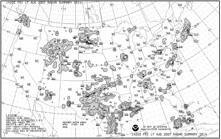
12 METEOROLOGY PRINTED REPORTS & FORECASTS SD RADAR WEATHER REPORTS Issued 35 minutes passed each hour Location and time (UTC) Echo pattern: CELL = single cell; LN = line; Coverage in tenths Type intensity and trend of weather otrw++/+ = Thunderstorm, very heavy rain showers/increasing intensity Azimuth (true north) and range (nm) of points defining the echoes Pattern movement Maximum tops Remarks Example: LIC 1825 CELL RW/NEW 162/30 D8 MT 180 AREA 1R-/NC 14/ /72 298/56 C3005 MT U140 ISOLD R ^JM11 KM1 LM121 MO1 NN2= INTERPRETATION AS FOLLOWS: LIC (LIMON, CO) RADAR WEATHER REPORT AT 1825 UTC A CELL OF ECHOES OF RAIN SHOWERS, NEWLY DEVELOPED 162 DEGREES, 30 NM, 8 MILES IN DIAMETER MAX TOP18000 FT AN AREA OF ECHOES 1 TENTH COVERAGE OF LIGHT RAIN NO CHANGE 14 DEGREES, 104 NM/105 DEGREES, 72 NM AND 298 DEGREES, 56 NM CELL MOVEMENT FROM 300 DEGREES AT 5 KNOTS. MAXIMUM TOP UNIFORM FEET REMARKS:ISOLATED RAIN

13 METEOROLOGY PRINTED REPORTS & FORECASTS PILOT REPORTS (PIREPS) PILOTS ARE EXPECTED TO REPORT TURBULENCE, ICING, OR OTHER HAZARDS ENCOUNTERED.

14 UA/OV GGG /TM 1450/FL 060/TP C182/SK 080 OVC/WX FV 04R/TA 05/WV /TB LGT/RM HVY RAIN Explanation: Type:...Routine pilot report Location: NM out on the 090 radial, Gregg County VOR Time: Zulu Altitude or Flight Level: 6,000 feet Aircraft Type:... Cessna 182 Sky Cover:... 8,000 overcast Visibility/Weather:... 4 miles in rain Temperature:...5 Celsius Wind: at 30 knots Turbulence:...Light Icing:... None reported
15 METEOROLOGY PRINTED REPORTS & FORECASTS PILOT REPORTS (PIREPS) Intensity Light Moderate Severe Extreme Aircraft Reaction Turbulence Intensity Loose objects in aircraft remain at rest. Unsecured objects are dislodged. Occupants feel definite strains against seat belts and shoulder straps. Occupants thrown violently against seat belts. Momentary loss of aircraft control. Unsecured objects tossed about. Aircraft is tossed violently about, impossible to control. May cause structural damage. Intensity Trace Light Moderate Severe Aircraft Reaction Icing Intensity Ice becomes perceptible. Rate of accumulation slightly greater than sublimation. Deicing/anti-icing equipment is not used unless encountered for an extended period of time (over 1 hour). The rate of accumulation may create a problem if flight is prolonged in this environment (over 1 hour). Occasional use of deicing/anti-icing equipment removes or prevents accumulation. It does not present a problem if this equipment is used. The rate of accumulation is such that even short encounters become potentially hazardous, and use of deicing/anti-icing equipment or diversion is necessary. The rate of accumulation is such that deicing/anti-icing equipment fails to reduce or control the hazard. Immediate diversion is necessary.
16 METEOROLOGY PRINTED REPORTS & FORECASTS PILOT REPORTS (PIREPS) FAA facilities are required to solicit PIREPs when the following weather conditions exist, are reported, or forecast to occur: 1. Ceilings at or below 5,000 feet. 2. Visibility reported on the surface or aloft is 5 miles or less. 3. Thunderstorms and related phenomenon. 4. Turbulence of moderate degree or greater. 5. Icing of light degree or greater. 6. Wind shear. 7. Volcanic ash clouds are reported or forecast. PIREP 1:28Z 11/18/03 DEH UUA /OV UKN/TM 0128/FL170/TP BE20/TA M08/TB MDT/IC SVR MXD PIREP 02:34Z 11/18/03 LAX UA /OV LAX350050/TM 0234/FL240/TP FA10/TA M25/WV 33036KT
17 TERMINAL AERODROME FORECAST (TAF) TAF KPIT Z 0918/ KT 5SM HZ FEW020 WS010/31022KT FM G25KT 3SM SHRA OVC015 TEMPO 0920/0922 1/2SM +TSRA OVC008CB FM KT 5SM SHRA BKN020 OVC040 PROB /1007 1SM -RA BR FM KT 6SM -SHRA OVC020 BECMG 1013/1015 P6SM SKC Z Issuance time: ALL times in UTC Z, 2-digit date, 4-digit time Z 0918/1024 Valid period, either 24 hours or 30 hours. The first two digits of EACH four digit number indicate the date of the valid period, the final two digits indicate the time (valid from 18Z on the 9th to 24Z on the 10th). In U.S. METAR: CORrected of; or AUTOmated ob for automated report with no human intervention; omitted when observer logs on KT Wind: 3 digit true-north direction, nearest 10 degrees (or VaRiaBle); next 2-3 digits for speed and unit, KT (KMH or MPS); as needed, Gust and maximum speed; 00000KT for calm; for METAR, if direction varies 60 degrees or more, Variability appended, e.g., 180V260 5SM Prevailing visibility; in U.S., Statute Miles & fractions; above 6 miles in TAF Plus6SM. Runway Visual Range: R; 2-digit runway designator Left, Center, or Right as needed; /, Minus or Plus in U.S., 4-digit value, FeeT in U.S., (usually meters elsewhere); 4-digit value Variability 4-digit value (and tendency Down, Up or No change) R28L/2600FT HZ Significant present, forecast and recent weather FEW020 Cloud amount, height and type: SKy Clear 0/8, FEW >0/8-2/8, SCaTtered 3/8-4/8, BroKeN 5/8-7/8, OVerCast 8/8; 3-digit height in hundreds of ft; Towering CUmulus or CumulonimBus in METAR; in TAF, only CB. Vertical Visibility for obscured sky and height VV004. More than 1 layer may be reported or forecast. In automated METAR reports only, CLeaR for clear below 12,000 feet OVC 010CB Temperature: degrees Celsius; first 2 digits, temperature / last 2 digits, dew-point temperature; Minus for below zero, e.g., M06 18/16 Altimeter setting: indicator and 4 digits; in U.S., A- inches and hundredths; (Q-hectoPascals, e.g., Q1013) A2992 WS010/31022KT In U.S. TAF, non-convective low-level ( 2,000 ft) Wind Shear; 3-digit height (hundreds of ft); / ; 3-digit wind direction and 2-3 digit wind speed above the indicated height, and unit, KT In METAR, ReMarK indicator & remarks. For example: Sea- Level Pressure in hectopascals & tenths, as shown: hpa; Temp/dew-point in tenths _C, as shown: temp. 18.2_C, dew-point 15.9_C RMK SLP045 T FM FroM: changes are expected at: 2-digit date, 2-digit hour, and 2-digit minute beginning time: indicates significant change. Each FM starts on a new line, indented 5 spaces TEMPO 0920/0922 TEMPOrary: changes expected for <1 hour and in total, < half of the period between the 2-digit date and 2-digit hour beginning, and 2-digit date and 2-digit hour ending time PROB /1007 PROBability and 2-digit percent (30 or 40): probable condition in the period between the 2-digit date & 2-digit hour beginning time, and the 2-digit date and 2-digit hour ending time BECMG 1013/1015 BECoMinG: change expected in the period between the 2-digit date and 2-digit hour beginning time, and the 2-digit date and 2-digit hour ending time

18 QNH Ground School 2011


19 METEOROLOGY PRINTED WEATHER FORECASTS TERMINAL AERODROME FORECAST (TAF)-PRACTICE
 REGIONAL EACH HAS MANY STATES")
20 METEOROLOGY PRINTED REPORTS & FORECASTS AREA FORECASTS (FA) REGIONAL EACH HAS MANY STATES
 Each contains HEADERS - WHEN AND HOW LONG VALID PRECAUTIONARY STATEMENT EVERY")
21 METEOROLOGY PRINTED REPORTS & FORECASTS AREA FORECASTS (FA) Issued 3 times daily, each covering a forecast period of 18 hours. WHY: Give us 2 very important pieces of information: projected forecast pattern and OUTLOOK (VFR, MVFR or IFR) Each contains HEADERS - WHEN AND HOW LONG VALID PRECAUTIONARY STATEMENT EVERY FA SYNOPSIS ( OVERALL PICTURE ) VFR CLOUDS AND WEATHER ( OUTLOOK )
22 FA Header Sample Forecast Valid Date/s Times Synopsis Validity date and time CLDS/WX Validity date and time OTLK Validity date and time Area Forecast - Southeast1830 AMD SYNOPSIS AND VFR CLDS/WX SYNOPSIS VALID UNTIL CLDS/WX VALID UNTIL OTLK VALID NC SC GA FL AND CSTL WTRS. SEE AIRMET SIERRA FOR IFR CONDS AND MTN OBSCN. TS IMPLY SEV OR GTR TURB SEV ICE LLWS AND IFR CONDS. NON MSL HGTS DENOTED BY AGL OR CIG.. SYNOPSIS...QSTNRY FNT FM NRN AL INTO NERN SC BECMG CDFNT AND CONTG INTO ATLC CSTL WTRS. LTL CHG THRU PD. ISOL TO WDLY SCT AFTN AND EVE TSRA WL DVLP ALG AND S OF FNT. DEEP MOIST AIRMASS WL REMAIN ACRS CNTRL/SRN FL WITH SCT DIURNAL TSRA EXP....POULOS... WHY: Pilot gets a general overview over many states in planning a X/C flight or it can be used In the absence of a terminal forecast at the destination.
23 Area Forecast (FA) Details SC...UPDT MTNS...OVC030 TOP 080. ISOL -SHRA/-TSRA. CB TOP FL Z BKN040. OTLK...MVFR CIG BR. PIEDMONT...OVC020 TOP 080. ISOL -SHRA/-TSRA. CB TOP FL Z SCT CI. OTLK...VFR BECMG 08Z MVFR BR. CSTL PLAIN...SCT030. ISOL -SHRA/-TSRA. CB TOP FL Z SCT CI. OTLK...VFR BECMG 08Z MVFR BR.. GA...UPDT NRN...SCT-BKN050 TOP 080. ISOL -SHRA/-TSRA. CB TOP FL Z SCT CI. OTLK...VFR BECMG 08Z MVFR BR. SRN...SCT-BKN040. ISOL -TSRA. CB TOP FL Z SCT060. OTLK...VFR BECMG 08Z MVFR BR.. FL PNHDL/NRN PEN...SCT030. AFT 21Z OCNL BKN030 IN WDLY SCT -TSRA. CB TOP FL Z FEW CI. OTLK...VFR BECMG 08Z MVFR BR. CNTRL PEN...SCT030. OCNL BKN030 IN SCT -TSRA. CB TOP FL Z FEW030 SCT100 SCT-BKN CI. OTLK...VFR. SRN PEN...SCT025 SCT-BKN130 LYRD FL250. OCNL BKN025 IN SCT -TSRA. CB TOP FL Z SCT025 SCT080 SCT CI. OTLK...VFR.
 WHY?")
24 METEOROLOGY PRINTED REPORTS & FORECASTS WINDS AND TEMPERATURE ALOFT (FD) WHY? CALCULATE GS/TRACK FAVORABLE CRUISE ALTITUDE FREEZING LEVELS
25 FD (Winds Aloft Forecast) Greater than 100 Kts i.e., Wind direction is coded as a number between 51 and 86 (vice 01 to 36) when the wind speed is 100 knots or greater. To derive the actual wind direction, subtract 50 from the first pair of numbers. To derive wind speed, add 100 to the second pair of numbers. For example, a forecast at 39,000 feet of "731960" shows a wind direction from 230 degrees (73-50=23) with a wind speed of 119 knots (100+19=119). Above 24,000 feet the temperature is assumed to be negative, therefore the third pair of numbers indicate a temperature of minus 60 degrees Celsius. If the wind speed is forecast to be 200 knots or greater, the wind group is coded as 199 knots. For example, "7799" is decoded as 270 degrees (77-50=27) at 199 knots or greater.
")
26 METEOROLOGY PRINTED REPORTS & FORECASTS WINDS AND TEMPERATURE ALOFT (FD) Practice
 -2 day prediction of convection activity [THUNDERSTORMS] SEVERE WEATHER WATCH (WW) Notification of severe thunderstorms (preceded by alert AWW) AIRMETS (WA) Concerns for")

27 METEOROLOGY PRINTED REPORTS & FORECASTS SEVERE WEATHER REPORTS/FORECASTS HURRICANE ADVISORIES (WH) Issued when at least 300 miles offshore. CONVECTIVE OUTLOOK (AC) -2 day prediction of convection activity [THUNDERSTORMS] SEVERE WEATHER WATCH (WW) Notification of severe thunderstorms (preceded by alert AWW) AIRMETS (WA) Concerns for GENERAL AVIATION PILOTS (light aircraft hazards) Issued for moderate icing/turbulence, winds > 30, CIG < 1000 and/or visibility < 3 over 50% area. Sierra identifier used for IFR conditions & mountain obscuration. Tango identifier used for turbulence, strong surface wind, LLWS. Zulu identifier used for icing and freezing levels. SIGMETS (WS) - Concerns for COMMERCIAL AND GA PILOTS - SIGNIFICANT WEATHER Issued for severe icing/turbulence, CAT, sand/dust storms, visibility < 3, and for volcanic ash. CONVECTIVE SIGMENTS (WST) significant convective activity and thunderstorms.


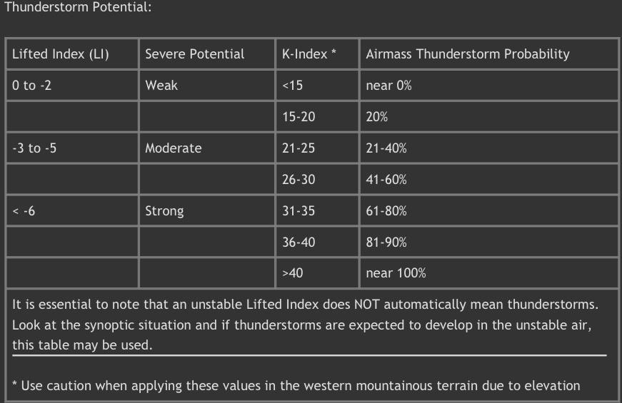
28 Stability for Instrument/Commercial First a bit of history. We used to have to determine stability potentially effecting our instrument-commercial flights by reviewing an old style of Lift Index Chart and compare the Lift and K-Indexes to Radar Summaries to get a reliable prediction of instability, convection, and thunderstorm development. Used to be on the Instrument written examination.
29

30 Stability for Instrument/Commercial NOAA has now made it easy!
 ATCSCC Real-time Airport Status Graphic TFRs Aeronautical Navigation Products NOTAM")
31 NOTICE TO AIRMEN: NOTAMS Aeronautical Information Advisories Database ATCSCC Operational Information System (OIS) ATCSCC Real-time Airport Status Graphic TFRs Aeronautical Navigation Products NOTAM Contractions JO Published NOTAMs National Flight Data Center Construction Notices Foreign Terminal Instrument Procedures NAV Canada NOTAM
32 METEOROLOGY PRACTICE EXERCISES STANDARD BRIEFING PRINTED PRACTICE MATERIALS
")


33 Graphic Weather Products Winds Aloft Comparison (text and graphic) Special notes If 9900 direction Variable and <= 5 kts Wind direction >36 indicates that wind speed is kts wind direction = value 50. (7602) = 76-50= 26 and 102 kts If wind is 99 then speed is => 200 kts


34 METEOROLOGY GRAPHIC WEATHER PRODUCTS SURFACE ANALYSIS Computer generated graphic of surface conditions. Patterns and station models help visualize conditions across the continental United States.

35 METEOROLOGY GRAPHIC WEATHER PRODUCTS Surface Analysis Chart The surface analysis chart depicts an analysis of the current surface weather. This chart is a computer prepared report that is transmitted every 3 hours and covers the contiguous 48 states and adjacent areas. A surface analysis chart shows the areas of high and low pressure, fronts, temperatures, dew points, wind directions and speeds, local weather, and visual obstructions.

36
 weather.")
37 METEOROLOGY Weather Depiction Charts This type of chart typically displays major fronts or areas of high and low pressure. The weather depiction chart also provides a graphic display of IFR, VFR, and MVFR (marginal VFR) weather. Areas of IFR conditions (ceilings less than 1,000 feet and visibility less than three miles) are shown by a hatched area outlined by a smooth line. MVFR regions (ceilings 1,000 to 3,000 feet, visibility 3 to 5 miles) are shown by a non-hatched area outlined by a smooth line. Areas of VFR (no ceiling or ceiling greater than 3,000 feet and visibility greater than five miles) are not outlined.
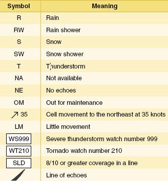
38 METEOROLOGY Radar Summary Charts RADAR SUMMARY CHARTS: Graphic depiction of RADAR SUMMARY REPORTS. Helps understand shape, size, intensity, and movement of adverse weather. Published every 35 minutes past the hour. SATELLITE WEATHER PICTURES GREAT No information if information is not reported, the chart will say NA. If no echoes are detected, the chart will say NE. Precipitation intensity contours intensity can be described as one of six levels and is shown on the chart by three contour intervals. Height of tops the heights of the echo tops are given in hundreds of feet MSL. Movement of cells individual cell movement is indicated by an arrow pointing in the direction of movement. The speed of movement in knots is the number at the top of the arrow head. LM indicates little movement. Type of precipitation the type of precipitation is marked on the chart using specific symbols. These symbols are not the same as used on the METAR charts. Echo configuration echoes are shown as being areas, cells, or lines. Weather watches severe weather watch areas for tornadoes and severe thunderstorms are depicted by boxes outlined with heavy dashed lines. The radar summary chart is a valuable tool for preflight planning. It does, however, contain several limitations for the usage of the chart. This chart depicts only areas of precipitation. It will not show areas of clouds and fog with no appreciable precipitation, or the height of the tops and bases of the clouds. Radar summary charts are a depiction of current precipitation and should be used in conjunction with current METAR and weather forecasts.
39


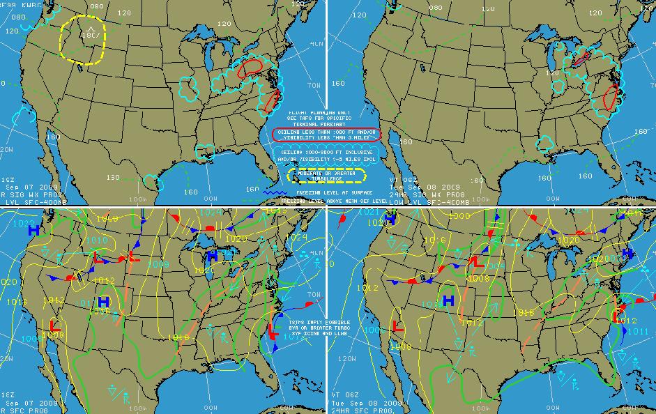
40 Low Level Significant Weather Prognostic Chart LOW LEVEL SIGNIFICANT WEATHER PROG CHART: 4 PANELS, 12/24 hr Upper/Lower levels
41 FRONTAL DESIGNATIONS ON SURFACE AND LOW LEVEL PROGNOSTIC CHARTS
42
![METEOROLOGY GRAPHIC WEATHER PRODUCTS SYMBOLS 1 = Tornado [not used] 14 = Moderate/Heavy rain shower 27 = Light Freezing Drizzle 2 = Thunderstorm 15 = Light rain shower 28 = Light Drizzle 3 =](/docs-images/84/90591516/images/43-0.jpg "Thunderstorm with rain 16 = Light rain 29 = Moderate Drizzle 4 = Thunderstorm with snow 17 = Moderate rain 30 = Heavy Drizzle 5 = Thunderstorm with freezing rain 18 = Heavy rain 31 = Light sleet")
43 METEOROLOGY GRAPHIC WEATHER PRODUCTS SYMBOLS 1 = Tornado [not used] 14 = Moderate/Heavy rain shower 27 = Light Freezing Drizzle 2 = Thunderstorm 15 = Light rain shower 28 = Light Drizzle 3 = Thunderstorm with rain 16 = Light rain 29 = Moderate Drizzle 4 = Thunderstorm with snow 17 = Moderate rain 30 = Heavy Drizzle 5 = Thunderstorm with freezing rain 18 = Heavy rain 31 = Light sleet shower 6 = Thunderstorm with hail or sleet 19 = Light snow shower 32 = Moderate/Heavy sleet shower 7 = Heavy Thunderstorm 20 = Moderate/Heavy snow shower 33 = Ice Crystals 8 = Thunderstorm with heavy rain 21 = Light snow 34 = Fog or Mist 9 = Thunderstorm with heavy snow 22 = Moderate snow 35 = Drifting snow [not used] 10 = Thunderstorm with heavy frzg rain 23 = Heavy snow 36 = Blowing sand/dust 11 = Thunderstorm with heavy sleet/hail 24 = Light Sleet 37 = Mix of rain and snow 12 = Moderate/Heavy freezing rain 25 = Moderate/Heavy Sleet 38 = Thunder without precipitation Instrument 13 = Light Ground freezing School rain = Moderate/Heavy freezing drizzle 39 = Smoke
 Convection SLIGHT(SLT) Convection HIGH not shown above Expect THUNDERSTORMS in areas of")
44 METEOROLOGY GRAPHIC WEATHER PRODUCTS 2 Day Convective Outlook. Heads up for instability! MODERATE (MDT) Convection SLIGHT(SLT) Convection HIGH not shown above Expect THUNDERSTORMS in areas of convective activity
 indicated by numbers.")
45 METEOROLOGY GRAPHIC WEATHER PRODUCTS FORECAST WINDS / TEMP ALOFT Two of 8 panels on a 12 hour forecast winds and temperatures. Wind/Speed shown by pointers and temperature ( C ) indicated by numbers. They are a graphic representation of the standard winds aloft forecast (FDs).

46 METEOROLOGY GRAPHIC WEATHER PRODUCTS VOLCANIC ASH GRAPHICS
47 METEOROLOGY WEATHER REPORTING FREQUENCY Weather Reports Issued Age when recv d Valid Period Aviation Routine Weather Reports (METAR) Hourly (50-55 past Hr.) Few Minutes to 30 Until the next METAR or SPECI issued RADAR Weather Reports (SD) Hourly (35 past Hr.) Approximately 20 mins. Until next SD issued Pilot Weather Reports (PIREP) On Observation Few Minutes to 30 Observed Data Terminal Aerodrome Forecast (TAF) 0000z, 0600z, 1200z, 1800z Forecasted Data 24 Hr. Forecast Winds and Temperature Aloft Forecast (FD), (CHART) 0000z, 1200z Forecasted Data Time interval of use is stated on forecast. Area Forecast (FA) 0045z, 0845z, 1745z Forecasted Data AIRMETS (WA) SIGMETS (WS) Every 6 Hrs. When specific SIGMET whether phenomena occurs Observed with forecasted data Observed with forecasted data Total 18 Hrs., Synopsis 18 Hrs., 12 Hr Forecast with 6 Hr Outlook. Maximum forecast period is 6 Hrs. Maximum forecast period is 4 Hrs. Convective SIGMETS (WST) Hourly (55 past the hour) Few minutes Until next WST or 2 Hrs. Outlook 2 to 6 Hours. Surface Weather Analysis (CHART) Every 3 Hours 1.5 to 2 Hours Observed Data RADAR Summary (CHART) Hourly (35 past Hr.) One Hour Until next SD report Weather Depiction (CHART) Every 3 Hours Approximately mins. Observed Data Low-Level Significant Weather Prognostic (CHART) 0000z, 0600z, 1200z, 1800z Forecasted Data Left Panels-12 Hr, Right Panel=24 Hr Composite Moisture Stability (CHART) 0000z, 1200z Approximately 1 Hour Observed Data Sever Weather Outlook (CHART) 0800z Forecasted Data Left Panel-1st 24Hrs,Right=2nd 24Hrs Constant Pressure Analysis (CHART) 0000z, 1200z 2 to 3 Hours Observed Data
 Graphical echo tops (ECHO TOPS) Graphical cloud tops (CLD TOPS) Graphical lightning strikes (LTNG) Graphical storm cell movement (CELL MOV) NEXRAD radar")
48 Electronic Flight Displays (EFD) /Multi-Function Display (MFD) Weather Graphical NEXRAD data (NEXRAD) Graphical METAR data (METAR) Textual METAR data Textual terminal aerodrome forecasts (TAF) City forecast data Graphical wind data (WIND) Graphical echo tops (ECHO TOPS) Graphical cloud tops (CLD TOPS) Graphical lightning strikes (LTNG) Graphical storm cell movement (CELL MOV) NEXRAD radar coverage (information displayed with the NEXRAD data) SIGMETs/AIRMETs (SIG/AIR) Surface analysis to include city forecasts (SFC) County warnings (COUNTY) Freezing levels (FRZ LVL) Hurricane track (CYCLONE) Temporary flight restrictions (TFR)


49 The Next Generation Weather Radar System (NEXRAD) The NEXRAD system is comprised of a series of 159 Weather Surveillance Radar 1988 Doppler (WSR-88D) sites situated throughout the United States as well as selected oversees sites. AIRMET information Box and addt l info AIRMET/SIGMET Legend information

50 Graphical METARS: Each flag is color coded to depict the type of weather that is currently reported at that station.
51 METEOROLOGY SOURCE OF WEATHER INFO AUTOMATED FLIGHT SERVICE STATION (AFSS) 24 HOURS A DAY Centralized (6 centers nationwide) service calls WX BRIEF ( ) Press 1 to speak to a Briefer; enter state code (FL=35). Press 2 to issue, cancel, or amend Notams (authorized persons only). Press 3 to listen to TIBS (transcribed information briefing service); enter state code. Press 4 to record a Fast File Flight Plan. Press 5 to hear Special Announcements.
 flight plan (or just local information request), type aircraft, point of depart, route of flight, destination, estimated time of")
52 METEOROLOGY SOURCE OF WEATHER INFO FSS provides person weather briefings. You are required to give the N number of the aircraft, type (VFR) flight plan (or just local information request), type aircraft, point of depart, route of flight, destination, estimated time of departure (ETD, and estimated time enroute (ETE) and TYPE OF BRIEFING (Outlook, Standard, or Abbreviated). OUTLOOK BRIEFING Used to make an initial judgment as to feasibility of the future flight (more than 6 hrs out). It provides initial forecast information that is limited in scope due to the timeframe of the planned flight.

53 METEOROLOGY SOURCE OF WEATHER INFO STANDARD BRIEFING DETAILED BRIEFING with all applicable information for the intended flight. Most complete briefing. Weather service gives you more than you will need.
54 STANDARD BRIEFING A standard briefing is the most complete report and provides the overall weather picture. This type of briefing should be obtained prior to the departure of any flight and should be used during flight planning. A standard briefing provides the following information in sequential order if it is applicable to the route of flight. 1. Adverse conditions this includes information about adverse conditions that may influence a decision to cancel or alter the route of flight. Adverse conditions include significant weather, such as thunderstorms or aircraft icing, or other important items such as airport closings. 2. VFR flight not recommended if the weather for the route of flight is below VFR minimums, or if it is doubtful the flight could be made under VFR conditions due to the forecast weather, the briefer may state that VFR is not recommended. It is the pilot s decision whether or not to continue the flight under VFR, but this advisory should be weighed carefully. 3. Synopsis an overview of the larger weather picture. Fronts and major weather systems that affect the general area are provided. 4. Current conditions this portion of the briefing contains the current ceilings, visibility, winds, and temperatures. If the departure time is more than 2 hours away, current conditions are not included in the briefing. 5. En route forecast a summary of the weather forecast for the proposed route of flight. 6. Destination forecast a summary of the expected weather for the destination airport at the estimated time of arrival (ETA). 7. Winds and temperatures aloft a report of the winds at specific altitudes for the route of flight. The temperature information is provided only on request. 8. Notices to Airmen (NOTAM) information pertinent to the route of flight which has not been published in the NOTAM publication. Published NOTAM information is provided during the briefing only when requested. 9. ATC delays an advisory of any known ATC delays that may affect the flight. 10. Other information at the end of the standard briefing, the FSS specialist provides the radio frequencies needed to open a flight plan and to contact EFAS. Any additional information

55 METEOROLOGY SOURCE OF WEATHER INFO ABBREVIATED Update of the standard briefing received by the pilot just prior to departure to find changes that may have occurred since the standard briefing.

56 In-flight Weather Service

57 In-flight Weather Service

58 Internet Services Weather

59 METEOROLOGY SOURCE OF WEATHER INFO AOPA and EAA Both organizations have flight planning and briefing internet access that integrates DUAT information. AOPA also permits AIRCRAFT PROFILE to provide not only briefing, route planning, but with aircraft performance will prepare a valid FLIGHT PLAN you can use to file a VFR flight plan with FSS. GOOD PLANNING WEATHER SITES AVIATION WEATHER AVIATION DIGITAL DATA SERVICES
. ENROUTE FLIGHT ADVISORY SERVICE (EFAS) Available advise (not radar service) for weather between 6 A.M.")
60 METEOROLOGY SOURCE OF WEATHER INFO IN-FLIGHT WEATHER SOURCES FSS Provide services by radio communications and via navigation facilities. Frequencies are indicated at SECTIONAL CHARTS and the AIRPORT FACILITIES DIRECTORY (AFD). ENROUTE FLIGHT ADVISORY SERVICE (EFAS) Available advise (not radar service) for weather between 6 A.M. to 10 P.M. flying between 5,000 17,500 AGL. TRANSCRIBED WEATHER BROADCAST (TWEB) Broadcasts on VORs and NDBs (Navigation facilities) hourly when so indicated on the sectional charts. VORs/NDB also broadcast HIWAS as required (Hazardous In-Flight Weather Advisories) as indicated on sectional charts. CENTER WEATHER ADVISORIES (CWA) Air Route Traffic Control Centers (ARTCC) are primarily used for IFR traffic but can be monitored (listen) for weather information within 50 miles of airspace under their jurisdiction HAZARDOUS INFLIGHT WEATHER ADVISTORY (HIWAS) Broadcasting hazardous weather information continuously over selected navigation aids (NAVAIDs). The broadcasts include advisories such as AIRMETS, SIGMETS, convective SIGMETS, and urgent PIREPs. NAVAIDs that have HIWAS capability are depicted on sectional charts with an H in the upper right corner of the identification box.
61 METEOROLOGY SOURCE OF WEATHER INFO AUTOMATED WEATHER REPORTING SYSTEMS Pilots can tune on radio (25nm up to ft AGL) or telephone these devices AWOS ASOS Automated Weather Observing Systems Voice synthesized real time weather data transmitted and available by phone on some fields without control towers. AWOS-A Altimeter setting only AWOS-1 Altimeter, wind speed, direction/gusts, temperature, & dew point AWOS-2 AWOS-1 plus visibility AWOS-3 AWOS-2 plus info on clouds and ceilings Automated Surface Observation Systems More common than AWOS contains all info as AWOS-3 PLUS variable cloud heights/visibility, rapid pressure changes, precipitation (intensity, accumulation, times beginning/ending). Two types designated: A01 (as described above) A02 (as described above PLUS capability to differ liquid/frozen precipitation
62 Analyzing Weather Summary Checklist-Printed Reports An aviation routine weather report (METAR) is an observation of surface weather written in a standard format which typically contains 10 or more separate elements. A non-routine aviation weather report (SPECI) is issued when a significant change in one or more of the elements of a METAR has occurred. Prevailing visibility is the greatest distance an observer can see and identify objects through at least half the horizon. Runway visual range (RVR) is based on what a pilot in a moving aircraft should see when looking down the runway. If included in a METAR, RVR is reported following prevailing visibility. A ceiling is the height above ground level of the lowest layer of clouds aloft which is reported as broken (BKN) or overcast (OVC), or the vertical visibility (VV) into an obscuration. Radar weather reports (SDs) define general areas of precipitation, particularly thunderstorms. The bases and tops of cloud layers, in-flight visibility, icing conditions, wind shear, and turbulence may be included in a pilot weather report (PIREP). Terminal aerodrome forecasts (TAFs) predict the weather at a specific airport for a 36-hour period An aviation area forecast (FA) is a good source of information for weather at airports which do not have terminal aerodrome forecasts, as well as for enroute weather. An estimate of wind direction in relation to true north, wind speed in knots, and the temperature in degrees Celsius for selected altitudes can be found in the winds and temperatures aloft forecast (FD). A convective outlook (AC) forecasts general thunderstorm activity for the next 48-hour period. Areas of possible severe thunderstorms or tornadoes are defined by a sever weather watch bulletin (WW).
63 Analyzing Weather Summary Checklist-Graphic Reports To get a picture of atmospheric pressure patterns at the earth s surface, you can refer to the surface analysis chart. The surface analysis chart is a good source of weather information over a wide area. The weather depiction chart is particularly useful during the preflight planning process for obtaining an overview of favorable and adverse weather conditions. A radar summary chart shows the location, size, shape, and intensity of areas of precipitation, as well as the direction of individual cell movement. Although the chart plots the location of lines and cells of hazardous thunderstorms, it does not show cloud formations. When single-site radar images are combined to produce the composite radar image, viewing distance is increased and ground clutter reduced. Both visibility and infrared (IR) imagery are available from weather satellites. The visibility picture is generally to indicate the presence of clouds as well as the cloud tops and the earth s surface, can be used to determine cloud height. The composite moisture stability chart can help avoid areas of icing and thunderstorms and determine the characteristics of a particular weather system by depicting the stability and moisture of a given airmass. The constant pressure analysis chart depicts observed weather data of six divergent levels. The information includes temperature, temperature/dew point spread, wind direction, wind speed, height of the pressure surface in meters, the change in height in the previous 12 hours, as well as upper air high, low, trough, ridge and fronts. The observed winds and temperatures aloft chart is useful for determining the optimum altitude for the most favorable winds and temperature for your flight.
64 Analyzing Weather Summary Checklist-Graphic Reports The U.S. Low-Level Significant Weather Prog Chart can not only help you avoid areas of significant turbulence, but also can provide you with information to help you avoid areas where temperatures are conducive to aircraft icing. The char is valid from the surface up to 24,000 feet. The upper panels of the LL Prog chart shows areas of nonconvective turbulence and freezing levels, as well as areas of IFR, marginal VFR, and VFR weather from the surface to 24,000 feet. The surface prog panels contained in the lower portion of the chart use standard symbols for fronts and pressure centers. The high-level significant weather prog chart is valid for altitudes from 24,000 feet up to 63,000 feet. It presents a forecast of thunderstorms, tropical cyclones, severe squalls, moderate or greater turbulence, widespread dust storms and sandstorms, tropopause heights, the location of the jet streams, and volcanic activity. The convective outlook chart is a two-panel chart, which forecasts thunderstorm activity over the next 48 hours. The day 1 panel depicts the outlook for general thunderstorm activity and sever thunderstorms for the fist 24-hour period beginning at 1200Z. The day 2 panel of the convective outlook chart provides a forecast for the second 24 hours forecast period. The forecast winds and temperatures aloft chart contains eight panels each of which corresponds to a forecast level-6, 9, 12, 18, 24, 30, 34 and 39 thousand feet MSL issued ant 1200Z and 0000Z and is valid for a 12 hour forecast period. The National Convective Weather Forecast (NCWF) depicts current convective weather and extrapolated forecasts of convective weather based on information from NEXRAD radar observations and cloud-ground lightning reports updated ever 5 minutes Volcanic Ash Forecast Transport and Dispersion (FAFTAD) summarizes ash in 6 and 12 hr intervals beginning 6 hours following a volcanic eruption.
65 Analyzing Weather Summary Checklist-Sources You can obtain a preflight briefing 24 hours a day at WX-BRIEF Request a standard briefing when you have received no previous weather information (within 6 hours of departure. Earlier, request an Outlook Briefing, and just before takeoff an Update Briefing You can receive an FAA-approved weather briefing using advance mobile device apps such as Foreflight or using DUATS and even file a flight plan using those devices. AIRMETs are issued ever 6 hours with amendments issued as necessary for weather phenomena which are potentially hazardous to light aircraft. AIRMETs are issued for moderate icing, moderate turbulence, sustain winds of 30 knots or more at the surface, ceilings less than 1,000 feet and/or visibility less than 3 miles affecting over 50%of an area at any one time, and extensive mountain obscuration..sigmets are issued for hazardous weather such as severe icing, severe and extreme turbulence, volcanic ash, and dust storms or sandstorms lower than 3 miles. Existing or forecast hazardous convective weather is significant to the safety of all aircraft contained in convective SIGMETS (WSTs). Enroute Flight Advisory Service (EFAS, or Flight Following) is one of the primary means of obtaining up-to-date weather information during flight. Below 18,000 feet it is available throughout the contiguous United States on MHz. Other frequencies are available at and above 18,000. In some areas, transcribed weather broadcasts (TWEB) provides recorded, route based weather information over selected VORs and NDBs. A center weather advisory (CWA) is an unscheduled advisory issued by ARTCC to alert pilots of existing or anticipated adverse weather conditions within the next 2 hours. It can precede the issuance of a SIGMET.
66 Analyzing Weather Summary Checklist-Sources Hazardous in-flight weather advisory service (HIWAS) is a continuous broadcast of summarized server weather forecast alerts (AWW), SIGMETs, convective SIGMETs, CWAs, AIRMETs, and urgent PIREPs over selected VORs.. The automated surface observation system (ASOS) and the automated weather obseration system (AWOS) are the systems from which pilots and weather forecasters obtain most surface observations. Airborne radar or lightning detection equipment usually can locate areas of hazardous weather ahead of your aircraft with greater reliability than ground-based radar.
KEY TO DECODING THE U.S. METAR OBSERVATION REPORT
 KEY TO DECODING THE U.S. METAR OBSERVATION REPORT Example METAR Report METAR KABC 121755Z AUTO 21016G24KT 180V240 1SM R11/P6000FT -RA BR BKN015 0VC025 06/04 A2990 RMK A02 PK WND 20032/25 WSHFT 1715 VIS
Weather Charts And Briefings
 Page M1 Chapter Thirteen Weather Charts And Briefings PIREPS, Progs & METARS The Telephone Briefing 1. [M4/1/9] When telephoning a weather briefing facility for preflight weather information, pilots should
Chapter 12 Weather Charts & Briefings: PIREPS, Progs & METARS
 Chapter 12 Weather Charts & Briefings: PIREPS, Progs & METARS The Telephone Briefing 1. [12-4/1/9] When telephoning a weather briefing facility for preflight weather information, pilots should A. identify
Preflight Weather Analysis Lesson 4 Part 4 of 4
 Preflight Weather Analysis Lesson 4 Part 4 of 4 Presented by Find-it Fast Books Unlimited FREE Downloads of this course available at www.finditfastbooks.org 1 The slide sequence for Lesson 4 is a little
TAF Decoder Courtesy of the Aviation Weather Center
 TAF Decoder Courtesy of the Aviation Weather Center A Terminal Aerodrome Forecast (TAF) is a concise statement of the expected meteorological conditions at an airport during a specified period (usually
TAF CCCC YYGGggZ YYHHHH dddff(f)gffkt VVVVSM [ww NNNhhh] [Wshhh/dddffKT] [TTTTT xxxx] repeated as needed
![TAF CCCC YYGGggZ YYHHHH dddff(f)gffkt VVVVSM [ww NNNhhh] [Wshhh/dddffKT] [TTTTT xxxx] repeated as needed](/thumbs/80/81003809.jpg "TAF CCCC YYGGggZ YYHHHH dddff(f)gffkt VVVVSM [ww NNNhhh] [Wshhh/dddffKT] [TTTTT xxxx] repeated as needed") Encoding TAFs Terminal Aerodome Forecast (TAF) Terminal forecasts for the world follow an internationally accepted format. The TAFs are issued four times daily for 24 hour periods beginning at 00Z, 06Z,
Encoding TAFs Terminal Aerodome Forecast (TAF) Terminal forecasts for the world follow an internationally accepted format. The TAFs are issued four times daily for 24 hour periods beginning at 00Z, 06Z,
Issue of SIGMET/AIRMET warning
 Issue of SIGMET/AIRMET warning 1 Presentation Objectives After this presentation session you will be able to: Warn for Hazardous weather phenomena using the correct ICAO coding with regards to SIGMET/AIRMET
Meteorology METARs. References: FTGU pages AWWS:
 Meteorology 5.09 METARs References: FTGU pages 160-163 AWWS: www.flightplanning.navcanada.ca 5.09 METARs MTPs: Weather Observing Stations METARs Weather Observing Stations Weather observation are taken
Meteorology METARs Weather Observing Stations. MTPs: 5.09 METARs References: FTGU pages AWWS:
 Meteorology 5.09 References: FTGU pages 160-163 AWWS: www.flightplanning.navcanada.ca MTPs: Weather Observing Stations 5.09 Weather Observing Stations Weather observation are taken every hour at selected
Gleim Private Pilot FAA Knowledge Test 2015 Edition, 1st Printing Updates July 2015
 Page 1 of 6 Gleim Private Pilot FAA Knowledge Test 2015 Edition, 1st Printing Updates July 2015 NOTE: Deleted text is displayed with a line through it. New text is shown with a blue background. If you
Aerodrome Forecast (TAF)
") AVIATION WEATHER PRODUCTS () Bureau of Meteorology Aviation Weather Services A is a coded statement of meteorological conditions expected at an and within a radius of five nautical miles of the reference
AVIATION WEATHER PRODUCTS () Bureau of Meteorology Aviation Weather Services A is a coded statement of meteorological conditions expected at an and within a radius of five nautical miles of the reference
STUDY UNIT SEVENTEEN GRAPHICAL AIRMAN S METEOROLOGICAL ADVISORY (G-AIRMET)
") STUDY UNIT SEVENTEEN GRAPHICAL AIRMAN S METEOROLOGICAL ADVISORY (G-AIRMET) 341 (10 pages of outline) 17.1 Product Description....................................................... 341 17.2 Issuance...............................................................
STUDY UNIT SEVENTEEN GRAPHICAL AIRMAN S METEOROLOGICAL ADVISORY (G-AIRMET) 341 (10 pages of outline) 17.1 Product Description....................................................... 341 17.2 Issuance...............................................................
Severe Icing Severe or Extreme Turbulence Dust storms and/or sand storms lowering visibilities to less than three (3) miles Volcanic Ash
 miles Volcanic Ash") SIGMETs A SIGMET advises of weather, other than convective activity, that is potentially hazardous to all aircraft. SIGMETs are issued (for the lower 48 states and adjacent coastal waters) for the following
SIGMETs A SIGMET advises of weather, other than convective activity, that is potentially hazardous to all aircraft. SIGMETs are issued (for the lower 48 states and adjacent coastal waters) for the following
ENSTROM 480B OPERATOR S MANUAL AND FAA APPROVED ROTORCRAFT FLIGHT MANUAL SUPPLEMENT GARMIN GDL 69AH XM WX SATELLITE WEATHER/RADIO RECEIVER
 ENSTROM 480B OPERATOR S MANUAL AND FAA APPROVED ROTORCRAFT FLIGHT MANUAL SUPPLEMENT GARMIN GDL 69AH XM WX SATELLITE WEATHER/RADIO RECEIVER * * * * * REPORT NO. 28-AC-062 HELICOPTER SERIAL NO. HELICOPTER
III.B. Weather Information
 III.B. Weather Information References: AC 00-6; AC 00-45; FAA-H-8083-25 Objectives Key Elements Elements Schedule Equipment IP s Actions SP s Actions Completion Standards The student should develop knowledge
Aviation Weather Reports
 Aviation Weather Reports Aviation Weather Reports METAR: hourly weather report (issued on the hour every hour) SPECI: special weather observations issued at times other than on the hour, as a result of
Answer Key. Page 1 of 5
 Answer Key Name: Score: [1] When telephoning a weather briefing facility for preflight weather information, pilots should state A. whether they intend to fly VFR only. B. the full name and address of the
Sport / Private Ground School. Lesson 7 Weather Products
 Sport / Private Ground School Lesson 7 Weather Products Weather Types Text Weather Actual Condi=ons Forecasts Graphical Weather Current Condi=ons Forecasts Text Weather Notes Winds are reported in reference
Section 7: Hazard Avoidance
 7.1 In-Flight Hazard Awareness Section 7: Hazard Avoidance As technology improves, pilots have more and more real-time information within reach in all phases of flight. Terrain proximity, real-time weather
ForeFlight Mobile Legends
 ForeFlight Mobile Legends ForeFlight, LLC 11th Edition - Covers ForeFlight Mobile v8.1 and later RADAR LEGENDS (WHEN FROM INTERNET) Snowy/Icy Precipitation Mixed Precipitation Rain Echo top (in 100 s of
CHAPTER 9 - SPECIAL OBSERVATIONS
 CHAPTER 9 - AL OBSERVATIONS 9.1 Introduction This chapter explains the criteria for taking special observations (). 9.2 Special Observations s are taken whenever mandatory criteria are met, and at the
Weather Legends in FOREFLIGHT MOBILE
 Weather Legends in FOREFLIGHT MOBILE 14th Edition Covers ForeFlight Mobile v9.4 on ipad Radar Legends (when from Internet) Snowy/Icy Precipitation Mixed Precipitation Rain Echo top (in 100 s of feet) ex:
USE OF WEATHER INFORMATION BY GENERAL AVIATION PILOTS: PROVIDERS AND PRODUCTS
 USE OF WEATHER INFORMATION BY GENERAL AVIATION PILOTS: PROVIDERS AND PRODUCTS William R. Knecht Civil Aerospace Medical Institute Oklahoma City, OK Data obtained from 211 general aviation (GA) pilots were
777 Neptune Groundschool Weather reporting & forecasts
 777 Neptune Groundschool 2018 Weather reporting & forecasts Weather Reporting Weather Forecast is a prediction of what the weather conditions will be in the future Weather Report tells the reader of what
Weather Legends in FOREFLIGHT MOBILE
 Weather Legends in FOREFLIGHT MOBILE 15th Edition Covers ForeFlight Mobile v9.6 on ipad Radar Legends (when from Internet) Snowy/Icy Precipitation Mixed Precipitation Rain Echo top (in 100 s of feet) ex:
ROYAL CANADIAN AIR CADETS PROFICIENCY LEVEL FOUR INSTRUCTIONAL GUIDE SECTION 5 EO C ANALYZE WEATHER INFORMATION PREPARATION
 ROYAL CANADIAN AIR CADETS PROFICIENCY LEVEL FOUR INSTRUCTIONAL GUIDE SECTION 5 EO C436.03 ANALYZE WEATHER INFORMATION Total Time: 90 min PREPARATION PRE-LESSON INSTRUCTIONS Resources needed for the delivery
Issue of SIGMET/AIRMET warning part II
 Issue of SIGMET/AIRMET warning part II 1 SIGMET SIGMET is warning information and hence it is of highest priority amongst other types of meteorological information provided to the aviation users. This
Flight Dispatcher Aviation Meteorology Required Knowledge
 Flight Dispatcher Aviation Meteorology Required Knowledge 3.1 THE EARTH'S ATMOSPHERE 1 Properties 2 Vertical Structure 3 ICAO Standard Atmosphere 3.2 ATMOSPHERIC PRESSURE 1 Pressure Measurements 2 Station
Aerodrome Reports and Forecasts
 Aerodrome Reports and Forecasts A Users Handbook to the Codes WMO-No. 782 Aerodrome Reports and Forecasts A Users Handbook to the Codes WMO-No. 782 Fifth edition November 2008 WMO-No. 782 World Meteorological
Atmospheric Pressure. Pressure Altimeter. Pressure Altimeter
 Atmospheric Pressure The : An instrument to measure altitude based on an aneroid barometer. It can be adjusted for changes in atmospheric pressure 1 2 Altimeter Setting Is not SLP, but close to it. If
National Transportation Safety Board Office of Aviation Safety Washington, D.C December 10, 2012 WEATHER STUDY DCA13RA025
 A. ACCIDENT National Transportation Safety Board Office of Aviation Safety Washington, D.C. 20594-2000 December 10, 2012 WEATHER STUDY DCA13RA025 Location: Monterrey, Mexico Date: December 9, 2012 Time:
METEOROLOGICAL AIRPORT REPORT
 1. Introduction 1.1. METAR IVAO TM Training Department Headquarters METEOROLOGICAL AIRPORT REPORT A METAR (Meteorological Airport Report) is a meteorological observation report (not a prediction) dedicated
TERMINAL AERODROME FORECAST
 1. Introduction TERMINAL AERODROME FORECAST Basically, a Terminal Aerodrome Forecast (or Terminal Area Forecast, TAF) is a message with a defined format with the objective to report a weather forecast
TAIWIN: Operational Concept Review
 TAIWIN: Operational Concept Review S.D. Green November 19, 2015 Overview Changes to FAR Parts 25 and 33 including FAR 25.1420 and Appendix O, will allow limited icing certification for transport category
GEN 3.5 METEOROLOGICAL SERVICES
 GEN-3.5-1 3.5.1 RESPONSIBLE SERVICE GEN 3.5 METEOROLOGICAL SERVICES The authority entrusted with the provision of aeronautical meteorological service is the Lithuanian Hydrometeorological Service. Lithuanian
METEOROLOGY PANEL (METP) WORKING GROUP- METEOROLOGICAL OPERATION GROUP (MOG) FIRST MEETING
 WORKING GROUP- METEOROLOGICAL OPERATION GROUP (MOG) FIRST MEETING") 8 28/7/15 METEOROLOGY PANEL (METP) WORKING GROUP- METEOROLOGICAL OPERATION GROUP (MOG) FIRST MEETING Gatwick, United Kingdom, 08 to 11 September 2015 Agenda Item 3: Matters relating to SADIS 3.3: Operations
8 28/7/15 METEOROLOGY PANEL (METP) WORKING GROUP- METEOROLOGICAL OPERATION GROUP (MOG) FIRST MEETING Gatwick, United Kingdom, 08 to 11 September 2015 Agenda Item 3: Matters relating to SADIS 3.3: Operations
and good his flight and take impact on Moderate Icing
 Learning Goals Weather Report Flying has always been about safety and good planning. A good pilot is the one who takes the time to plan his flight and take into account all of the variables. One of the
Earth and Atmospheric Sciences. Sky condition. Prof. J. Haase EAS535 EAS535
 Sky condition Prof. J. Haase Federal Meteorological Handbook http://www.ofcm.gov/fmh-1/fmh1.htm Estimating cloud height Report cloud levels to nearest 100 feet below 5000 feet (in practice, human observers
Air Traffic Control Weather Certification
 3 d Weather Squadron Air Traffic Control Weather Certification Mr B.J. Ortner, 3 WS/DOV Weather Forecaster Current as of: 8 June 2017 Overview Requirements/References RGAAF (KGRK) Observations HAAF (KHLR)
July 13, 2017 Session #1 In Lieu of the Surface Observation Including EWINS Authority, RTMA, Web Cams, and Remote Observation Systems
 July 13, 2017 Session #1 In Lieu of the Surface Observation Including EWINS Authority, RTMA, Web Cams, and Remote Observation Systems Part 121 Operator Perspective: Equivalent Level of Safety Using Remote
2. A mountain breeze (katabatic wind) blows : DOWN THE SLOPE DURING THE NIGHT
 blows : DOWN THE SLOPE DURING THE NIGHT") MODEL E-EXAM (ATPL) NO.3 1. Among the ten groups of clouds, the following two are mentioned specifically in MET-reports and forecasts intended for aviation: CUMULONIMBUS AND TOWERING CUMULUS 2. A mountain
MODEL E-EXAM (ATPL) NO.3 1. Among the ten groups of clouds, the following two are mentioned specifically in MET-reports and forecasts intended for aviation: CUMULONIMBUS AND TOWERING CUMULUS 2. A mountain
Section 1 THE AVIATION WEATHER SERVICE PROGRAM NATIONAL OCEANIC AND ATMOSPHERIC ADMINISTRATION (NOAA)
") Section 1 THE AVIATION WEATHER SERVICE PROGRAM Providing weather service to aviation is a joint effort of the National Weather Service (NWS), the Federal Aviation Administration (FAA), the Department of
Section 1 THE AVIATION WEATHER SERVICE PROGRAM Providing weather service to aviation is a joint effort of the National Weather Service (NWS), the Federal Aviation Administration (FAA), the Department of
PREFLIGHT WEATHER ANALYSIS MADE EASY
 PREFLIGHT WEATHER ANALYSIS MADE EASY ebook Series Version 1.3 Copyright 2012 Find-it Fast Books No part of this ebook, or in its entirety, may be reproduced or retransmitted by any electronic or mechanical
AERODROME METEOROLOGICAL OBSERVATION AND FORECAST STUDY GROUP (AMOFSG)
") 24/4/13 AERODROME METEOROLOGICAL OBSERVATION AND FORECAST STUDY GROUP (AMOFSG) TENTH MEETING Montréal, 17 to 19 June 2013 Agenda Item 6: Forecasting at the aerodrome and in the terminal area and ATIS requirements
24/4/13 AERODROME METEOROLOGICAL OBSERVATION AND FORECAST STUDY GROUP (AMOFSG) TENTH MEETING Montréal, 17 to 19 June 2013 Agenda Item 6: Forecasting at the aerodrome and in the terminal area and ATIS requirements
Metar And Taf Decoding
 Metar And Taf Decoding 1 / 6 2 / 6 3 / 6 Metar And Taf Decoding examples: kmem 230853z auto 18014g18kt 10sm clr 16/m02 a3008 rmk ao2 slp117 t01561022 tsno $ klax 161550z cor 11004kt 2 1/2sm hz bkn011 bkn015
Decoding Observations and Terminal Aerodrome Forecasts. Weather Observer/Forecaster O-LD 18 th Weather Squadron Ft Polk, LA
 Decoding Observations and Terminal Aerodrome Forecasts Weather Observer/Forecaster O-LD 18 th Weather Squadron Ft Polk, LA Part I. Decoding Observations What types of data goes into a weather observation?
Preflight Weather Analysis Lesson 2 Part 2 of 4
 Preflight Weather Analysis Lesson 2 Part 2 of 4 Presented by Find-it Fast Books Unlimited FREE Downloads of this course available at www.finditfastbooks.org 1 NATIONAL MOSAIC RADAR CHART Precipitation
Introduction to SIGMET. 28 June 2016 Japan Meteorological Agency
 Introduction to SIGMET 28 June 2016 Japan Meteorological Agency SIGMET Definition SIGMET information Information issued by a meteorological watch office concerning the occurrence or expected occurrence
The Informed Scheduler
 The Informed Scheduler Thursday, January 21, 2016 1:00 p.m. 2:30 p.m. PRESENTED BY: Vinton Brown, Flight Safety International James M. Kohler, Chief Pilot, DuPont Andrew M. Bourland, CAM, Chief Pilot,
Weather Technology in the Cockpit (WTIC) Shortfall Analysis of Weather Information in Remote Airspace Friends and Partners of Aviation Weather Summer
 Shortfall Analysis of Weather Information in Remote Airspace Friends and Partners of Aviation Weather Summer") Weather Technology in the Cockpit (WTIC) Shortfall Analysis of Weather Information in Remote Airspace Friends and Partners of Aviation Weather Summer Meeting Tim Myers Metron Aviation August 26, 2015 2
Weather Technology in the Cockpit (WTIC) Shortfall Analysis of Weather Information in Remote Airspace Friends and Partners of Aviation Weather Summer Meeting Tim Myers Metron Aviation August 26, 2015 2
U.S. Aviation Meteorology
 U.S. Aviation Meteorology U.S. Aviation Meteorology FAA is U.S. Meteorological Authority for Aviation FAA and NWS share costs and ownership of observation systems ASOS/METAR Weather Radar ITWS NWS is U.S.
2012 National SAFECON SCAN Test
 Today is Friday, November 18, 2011. Your school's flight team has recently qualified for the National SAFECON. You have a couple days off from school and decide to return to your hometown of Rhinelander,
METEOROLOGY. 1 The average height of the tropopause at 50 N is about A 14 km B 16 km C 11 km D 8 km
 1 The average height of the tropopause at 50 N is about A 14 km B 16 km C 11 km D 8 km 2 In the lower part of the stratosphere the temperature A is almost constant B decreases with altitude C increases
Science Olympiad Meteorology Quiz #2 Page 1 of 8
 1) The prevailing general direction of the jet stream is from west to east in the northern hemisphere: 2) Advection is the vertical movement of an air mass from one location to another: 3) Thunderstorms
AERODROME METEOROLOGICAL OBSERVATION AND FORECAST STUDY GROUP (AMOFSG)
") AMOFSG/9-SN No. 31 22/8/11 AERODROME METEOROLOGICAL OBSERVATION AND FORECAST STUDY GROUP (AMOFSG) NINTH MEETING Montréal, 26 to 30 September 2011 Agenda Item 5: Observing and forecasting at the aerodrome
AMOFSG/9-SN No. 31 22/8/11 AERODROME METEOROLOGICAL OBSERVATION AND FORECAST STUDY GROUP (AMOFSG) NINTH MEETING Montréal, 26 to 30 September 2011 Agenda Item 5: Observing and forecasting at the aerodrome
Calculates CAT and MWT diagnostics. Paired down choice of diagnostics (reduce diagnostic redundancy) Statically weighted for all forecast hours
 Statically weighted for all forecast hours") 1 Major Upgrades All diagnostics mapped to Eddy Dissipation Rate ADDS now displays EDR values CAT diagnostic extended down to 1000 feet MSL & forecast hours 15 and 18 New Mountain Wave diagnostic CAT diagnostics
1 Major Upgrades All diagnostics mapped to Eddy Dissipation Rate ADDS now displays EDR values CAT diagnostic extended down to 1000 feet MSL & forecast hours 15 and 18 New Mountain Wave diagnostic CAT diagnostics
QLD-S NSW-E NSW-W VIC TAS. A HEADER giving details of the time of issue and the associated validity period.
 FLIGHT FORECASTS Flight Forecasts are issued on request for flights for which GAFs are not available. They are subject to the requirements of AIP GEN 3.5 para 3.1 and AIP GEN 3.5 para 10.3. Flight forecasts
Subject: Aviation Weather Services Date: 11/14/16 AC No: 00-45H Initiated by: AFS-400 Change:
 U.S. Department of Transportation Federal Aviation Administration Advisory Circular Subject: Aviation Weather Services Date: 11/14/16 AC No: 00-45H Initiated by: AFS-400 Change: The Federal Aviation Administration
How to issue SIGMET. SIGMET Seminar for Asia/Pacific Region Bangkok, Thailand, July 2007
 How to issue SIGMET SIGMET Seminar for Asia/Pacific Region Bangkok, Thailand, 11-13 July 2007 Shikembaru, Toru 志堅原透 Japan Meteorological Agency (JMA) 日本気象庁 Japan Meteorological Agency 1 Contents of lecture
Multi-Function Display Pilot s Guide Addendum
 Multi-Function Display Pilot s Guide Addendum Software Release 4.2 or Later 600-00344-000 Rev: 01-1- EX500/EX600 Document Revision History Date Revision Description February 21, 2018 00 Initial Release
AVIATION WEATHER SERVICES
 AVIATION WEATHER SERVICES U.S. DEPARTMENT OF COMMERCE NATIONAL OCEANIC AND ATMOSPHERIC ADMINISTRATION NATIONAL WEATHER SERVICE U.S. DEPARTMENT OF TRANSPORTATION FEDERAL AVIATION ADMINISTRATION AC 00-45E
GEN 3.5 METEOROLOGICAL SERVICES
 AIP GEN 3.5-1 GEN 3.5 METEOROLOGICAL SERVICES 1. RESPONSIBLE SERVICE The meteorological services for civil aviation at Jordan are provided by the Jordanian Meteorological Department. Postal Address: Director
Your Source for Global Aviation Forecasts
 Your Source for Global Aviation Forecasts (831) 238-5054 100 Sky Park Drive Monterey, CA 93940 Weather4Cast.com Live Weather Data Feeds Weather4Cast.com provides Live Aviation Weather Data Feeds formatted
GRAPHICAL AREA FORECASTS (GAF) feet. Flight Information Region boundary QLD-S NSW-E VIC TAS
 feet. Flight Information Region boundary QLD-S NSW-E VIC TAS") GRAPHICAL AREA FORECASTS (GAF) Unlike at TAF, a Graphical Area Forecasts (GAFs) does not describe conditions expected at a particular location, it refers to a defined area and is intended for use in planning
GRAPHICAL AREA FORECASTS (GAF) Unlike at TAF, a Graphical Area Forecasts (GAFs) does not describe conditions expected at a particular location, it refers to a defined area and is intended for use in planning
Recap of the NTSB PIREP Forum: Optimizing Safety Benefits for Pilots, ATC, and Meteorologists. Paul Suffern NTSB Meteorologist
 Recap of the NTSB PIREP Forum: Optimizing Safety Benefits for Pilots, ATC, and Meteorologists Paul Suffern NTSB Meteorologist 1 2 Wx Accident Trend 3 Preflight Planning TAF KRDU 162340Z 1700/1724 28003KT
MxVision WeatherSentry Web Services Content Guide
 MxVision WeatherSentry Web Services Content Guide July 2014 DTN 11400 Rupp Drive Minneapolis, MN 55337 00.1.952.890.0609 This document and the software it describes are copyrighted with all rights reserved.
MET 3502 Synoptic Meteorology. Lecture 5: Surface Weather Elements
 MET 3502 Synoptic Meteorology Lecture 5: Surface Weather Elements Surface Weather Elements Not observations of the surface, but Observations made by an observer (or instrument) at the surface Example:
Explanation and decode for code figures used in the Wokingham 0900 and 1500 GMT observations
 Appendix 2. Explanation and decode for code figures used in the Wokingham 0900 and 1500 GMT observations VV : Visibility. Code figures 00 to 50 are in km and tenths e.g. 01 = 0.1 km = 100 m, 33 = 3.3 km,
Effective: SPECI ALERTING
 AUSTRALIA AERONAUTICAL INFORMATION SERVICE AIRSERVICES AUSTRALIA GPO BOX 367, CANBERRA ACT 2601 Phone: 02 6268 4874 Email: aim.editorial@airservicesaustralia.com Effective: AERONAUTICAL INFORMATION CIRCULAR
ERTH 465 Fall Laboratory Exercise 5. Surface Weather Observations (METARS) and Frontal Analysis (300 pts)
 and Frontal Analysis (300 pts)") ERTH 465 Fall 2017 Laboratory Exercise 5 Surface Weather Observations (METARS) and Frontal Analysis (300 pts) Insert in ringed-three hole binder. Point deductions for sloppy or late work. Due date: Tuesday
ERTH 465 Fall 2017 Laboratory Exercise 5 Surface Weather Observations (METARS) and Frontal Analysis (300 pts) Insert in ringed-three hole binder. Point deductions for sloppy or late work. Due date: Tuesday
Syllabus details and associated Learning Objectives (A) and EIR METEOROLOGY
 and EIR METEOROLOGY") Syllabus details associated Learning Objectives 050 00 00 00 METEOROLOGY 050 01 00 00 THE ATMOSPHERE 050 01 02 00 Air temperature 050 01 02 04 Lapse rates LO Describe qualitatively quantitatively the temperature
Syllabus details associated Learning Objectives 050 00 00 00 METEOROLOGY 050 01 00 00 THE ATMOSPHERE 050 01 02 00 Air temperature 050 01 02 04 Lapse rates LO Describe qualitatively quantitatively the temperature
Subject: Aviation Weather Services Date: 1/8/18 AC No: 00-45H Initiated by: AFS-400 Change: 1
 U.S. Department of Transportation Federal Aviation Administration Advisory Circular Subject: Aviation Weather Services Date: 1/8/18 AC No: 00-45H Initiated by: AFS-400 Change: 1 1 PURPOSE OF THIS ADVISORY
1 of 5 20/01/2015 2:05 PM
 1 of 5 20/01/2015 2:05 PM AWWS News : There are 2 active notices. Last update: 2014/09/17 Request Generated 01/20/2015 at 22:01:08 UTC. Weather information available at that time is displayed. Go to a
THUNDERSTORMS-RISK FACTORS IN AVIATION. CASE STUDY: AREA OF RESPONSABILITY OF THE BUCHAREST- OTOPENI AERODROME ON
 RISCURI ŞI CATASTROFE, NR. XIV, VOL. 17, NR.2/2015 THUNDERSTORMS-RISK FACTORS IN AVIATION. CASE STUDY: AREA OF RESPONSABILITY OF THE BUCHAREST- OTOPENI AERODROME ON 30.06.2009 C. L. ŞCHIOPU 1, NICOLETA
Subject No 8 - PPL Meteorology
 Subject No 8 - PPL Meteorology Notes: This syllabus is principally based on the meteorology as applicable to flying a single piston-engine General Aviation type aeroplane or helicopter, within New Zealand
GEMPAK Symbols, Lines, and Markers APPENDIX C. SYMBOLS, LINES, and MARKERS. Past Weather. Pressure tendency with change.
 APPENDIX C SYMBOLS, LINES, and MARKERS SYMBOLS The World Meteorological Organization (WMO) has established a standard set of symbols depicting descriptive reports of certain types of weather observations.
Aeronautical Information Service
 , St. Maarten and The Netherlands EFFECTIVE DATE: 31 MARCH 2016 KNMI Meteorological Services Information for TNCB, TNCE and TNCS Page: GEN 2.7-1 Sunrise / sunset tables 1. The tables on the following pages
AOPA. Mitigating Turbulence Impacts in Aviation Operations. General Aviation Perspective
 AOPA Mitigating Turbulence Impacts in Aviation Operations General Aviation Perspective Rune Duke Senior Director, Airspace & Air Traffic Services Aircraft Owners & Pilots Association AOPA Air Safety Institute
General Aviation Pilot s Guide to Preflight Weather Planning, Weather Self-Briefings, and Weather Decision Making. Federal Aviation Administration
 General Aviation Pilot s Guide to Preflight Weather Planning, Weather Self-Briefings, and Weather Decision Making Federal Aviation Administration General Aviation Pilot s Guide Preflight Planning, Weather
PLOTTED DATA AROUND STATION CIRCLE ON SURFACE ANALYSIS CHART TYPE OF HIGH CLOUD TYPE OF WIND SPEED MIDDLE CLOUD SEA-LEVEL PRESSURE
 WIND SPEED WIND DIRECTION TYPE OF HIGH CLOUD TYPE OF MIDDLE CLOUD SEA-LEVEL PRESSURE TOTAL AMOUNT OF SKY COVERED BY CLOUDS TEMPERATURE F VISIBILITY PRESENT WEATHER DEW POINT F TYPE OF LOW CLOUD 31 2 30
DEPARTMENT OF EARTH & CLIMATE SCIENCES SAN FRANCISCO STATE UNIVERSITY. Metr Fall 2014 Test #1 September 30, 2014
 DEPARTMENT OF EARTH & CLIMATE SCIENCES SAN FRANCISCO STATE UNIVERSITY NAME Metr 302.02 Fall 2014 Test #1 September 30, 2014 200 pts (4 pts each answer) Part I. Surface Chart Interpretation. Questions 1
Sources of Hourly Surface Data and Weather Maps for the U.S.
 Sources of Hourly Surface Data and Weather Maps for the U.S. Weather Underground Weather Underground http://www.wunderground.com/history/ maintains a deep archive of hourly reports for around the world.
Atmospheric Moisture. Atmospheric Moisture:Clouds. Atmospheric Moisture:Clouds. Atmospheric Moisture:Clouds
 Sec A Atmospheric Moisture I. Measuring Relative Humidity A. A Psychrometer is an instrument for measuring relative humidity B. A common psychrometer uses two thermometers with a wet gauze wrapped over
GRAPHICAL NZ SIGWX Graphical New Zealand Significant Weather Chart
 GRAPHICAL NZ SIGWX Graphical New Zealand Significant Weather Chart USER GUIDE GRAPHICAL NZ SIGWX (Graphical New Zealand Significant Weather Chart) 1. Introduction 1.1 The GNZSIGWX Chart provides forecast
Mechanical Turbulence Wind forms eddies as it blows around hanger, stands of trees or other obstructions
 Turbulence Low-level Turbulence below 15,000 feet consists of Mechanical Turbulence Convective Turbulence Frontal Turbulence Wake Turbulence Mechanical Turbulence Wind forms eddies as it blows around hanger,
AWOS Level Descriptions
 AWOS Level Descriptions AWOS System Configurations. The AWOS is a modular system utilizing a central processor which may receive input from several sensors. Eight standard groups of sensors are defined
Aviation Weather For Pilots. Aviation Weather Decoded
 Aviation Weather For Pilots Aviation Weather Decoded Presented by Mike Cetinich About Your Instructor n B.S. Meteorology San Jose State University n Flight Training n Career at Jeppesen (30+ years) Aviation
KMD 550/850. Flight Information Services (FIS) Pilot s Guide Addendum. Multi-Function Display. For Software Version 02/02 and later
 Pilot s Guide Addendum. Multi-Function Display. For Software Version 02/02 and later") N B KMD 550/850 Multi-Function Display Flight Information Services (FIS) Pilot s Guide Addendum For Software Version 02/02 and later 006-18237-0000 The information contained in this manual is for reference
N B KMD 550/850 Multi-Function Display Flight Information Services (FIS) Pilot s Guide Addendum For Software Version 02/02 and later 006-18237-0000 The information contained in this manual is for reference
WEATHER THEORY. Weather Theory Page 100 Aviation Seminars. Measurement Of Temperature, Pressure And Moisture. Stability (Cont)
") Weather Theory Page 100 WEATHER THEORY Measurement Of Temperature, Pressure And Moisture The primary cause of all changes in the earth s weather is variation of solar energy received by the Earth s regions..
Weather Theory Page 100 WEATHER THEORY Measurement Of Temperature, Pressure And Moisture The primary cause of all changes in the earth s weather is variation of solar energy received by the Earth s regions..
FAA-NWS Aviation Weather Weather Policy and Product Transition Panel. Friends and Partners in Aviation Weather October 22, 2014 NOAA NOAA
 FAA-NWS Aviation Weather Weather Policy and Product Transition Panel Friends and Partners in Aviation Weather October 22, 2014 Airplanes have changed. Lockheed Constellation Airbus A380 Aviation weather
FLYSAFE meteorological hazard nowcasting driven by the needs of the pilot
 FLYSAFE meteorological hazard nowcasting driven by the needs of the pilot R. W. Lunnon, Met Office, Exeter, EX1 3PB, United Kingdom., Thomas Hauf, Thomas Gerz, and Patrick Josse. 1. Introduction The FLYSAFE
Weather can change quickly...are you on top of the changes?
 Weather Access Bob Glancy NOAA National Weather Service, Boulder, CO Near Cedar Point, CO May 9, 2004 Weather can change quickly...are you on top of the changes? National Weather Service Local offices:
CHAPTER THREE Mechanics of Frontal Systems
 Mechanics of Frontal Systems 300. INTRODUCTION The purpose of this chapter is to introduce the student to various frontal systems, including their formation, flight conditions, and associated weather patterns,
Information Note on the Webpage for Significant Convection Monitoring and Forecast
 Information Note on the Webpage for Significant Convection Monitoring and Forecast The webpage displays both the real-time products for monitoring of significant convection and forecast products for significant
SEYCHELLES TECHNICAL STANDARDS
 SEYCHELLES TECHNICAL STANDARDS Aviation Meteorological Standards Seychelles Technical Standards Aviation Meteorological Standards Issue 01 July 2017 CONTENTS (general layout) FOREWORD Aviation Meteorological
AWE: Aviation Weather Data Visualization Environment
 AWE: Aviation Weather Data Visualization Environment Lilly Spirkovska NASA Ames Research Center Suresh K. Lodha Univ. of California, Santa Cruz Abstract The two official sources for aviation weather reports
ESCI 241 Meteorology Lesson 9 Clouds and Fog
 References and Reading: MT Chapter 7 FORMATION OF CLOUDS ESCI 241 Meteorology Lesson 9 Clouds and Fog When air becomes saturated with water vapor, any excess water vapor condenses to form clouds The air
B KMD 550/850 Multi-Function Display Quick Reference For Software Version 01/14 or Later
 F N B KMD 550/850 Multi-Function Display Quick Reference For Software Version 01/14 or Later 12 1 11 2 3 4 10 13 9 6 5 7 1. Brightness Control 2. Data Card 3. Display 4. Available Functions Legend 5. On/Off
Sources of Hourly Surface Data and Weather Maps for the U.S.
 Sources of Hourly Surface Data and Weather Maps for the U.S. Weather Underground Weather Underground http://www.wunderground.com/history/ maintains a deep archive of hourly reports for around the world.
Lab 19.2 Synoptic Weather Maps
 Lab 19.2 Synoptic Weather Maps Name: Partner: Purpose The purpose of this lab is to have you read and interpret the information displayed on synoptic weather maps. You will also learn the techniques used