Your Source for Global Aviation Forecasts
|
|
|
- Charlotte Owens
- 6 years ago
- Views:
Transcription


1 Your Source for Global Aviation Forecasts (831) Sky Park Drive Monterey, CA 93940

2 Weather4Cast.com Live Weather Data Feeds Weather4Cast.com provides Live Aviation Weather Data Feeds formatted to work with your flight following/planning and routing software. We offer numerous live data streams which are available via several formats including WMS, HTML, REST API, Text Products, , FTP and can be customized to work with your system. The following list includes live weather data feeds available via the Qatar Airways TOPS flight watch platform which are provided and supported by Weather4Cast.com. Please note that many of these layers are interactive when viewed via the TOPS Flight Watch Platform and, hence, the user can zoom in and out for additional details as well as add or remove any layer. The following pages include these live weather data feeds available via the Qatar Airways TOPS flight watch platform which are provided and supported by Weather4Cast.com [click any title below to quickly advance to that page]. Tropical Weather Overlay Volcanic Ash Overlay Satellite Weather Overlay Sigmet Overlay Convective Overlay Icing Threat Overlay Freezing Level Overlay Turbulence Overlay FIR BoundaryOverlay Weather Radar Overlay SigWx Prog Overlay Upper Wind Overlay Each weather layer is described in detail below including issue times and an example image(s) for each layer. If a weather layer is required that is not listed, Weather4Cast. com can custom design any layer requested and provide this layer to work with your flight watch system. 2

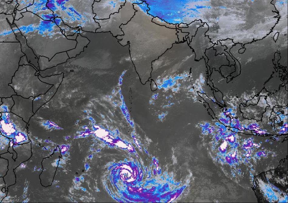
3 Tropical Weather Overlay The Tropical Weather Layer consists of current positions and forecasted tracks of tropical storms, hurricanes, tropical cyclones and typhoons across the globe. Tropical systems are represented by standard symbols and have embedded links to tropical weather discussions provided by various government agencies. The Tropical Weather Layer includes the name of the system being tracked, the projected path with estimated time of impact and wind radius displayed graphically. The Tropical Weather Layer is updated 4 times daily at 00Z, 06Z, 12Z and 18Z with data compiled from the seven governmental tropical centers located around the world. The refresh time and rate for the Tropical Weather Overlay via TOPS is updated every 15 minutes of every hour i.e. XX:00, XX:15, XX:30 and XX:45. The following is an example screenshot of the Tropical Weather Layer via the TOPS Flight Watch platform. Please note that this layer will include a legend as well as interactive links providing further details when viewed via the TOPS platform. Tropical Weather Overlay 3

4 Volcanic Ash Overlay The Volcanic Ash Layer (ASHTAM) is a compilation of all advisories issued by the official VAACs across the globe with the location of the volcano, volcano name and observation listed within the layer. These advisories are issued by 9 centers: VAAC Anchorage, VAAC Montreal, VAAC London, VAAC Washington, VAAC Wellington, VAAC Buenos Aires, VAAC Toulouse, VAAC Darwin and VAAC Tokyo. Active volcanoes are listed with the standard symbols with a red volcano symbol delineating a volcano with cloud observation while a yellow volcano symbol will represent a volcano without a cloud observation. Every active volcano will have embedded links to volcanic discussions provided by the listed volcanic agencies around the world with ash cloud observations and forecasts color coded and provided for each volcano. The Volcanic Ash Overlay is updated 4 times per hour i.e. every 15 minutes of every day to provide the most up-to-date volcanic ash advisories available. The refresh time and rate for the Volcanic Ash Overlay via TOPS is updated every 15 minutes of every hour i.e. XX:00, XX:15, XX:30 and XX:45. The following is an example screenshot of the Volcanic Ash Layer via the TOPS Flight Watch platform with the first image a global perspective and second image when the user zooms into the layer for further details. In addition, this layer will include a legend as well as interactive links providing further details when viewed via the TOPS platform. 4
 5")
5 Volcanic Ash Overlay Volcanic Ash Overlay (Zoomed In) 5

6 Satellite Weather Overlay The Satellite Layer consists of live global satellite feeds from GOES-E, GOES-W, MTSAT and METEOSAT with Infrared and Visible imagery provided across the world. Infrared satellite imagery is provided via Grayscale and Color Enhanced with Visible satellite imagery provided via Grayscale with a global blend provided using the listed satellite sources. Satellite coverage is provided across the world from 70N to 70S latitude with both visible and infrared satellite imagery covering most of the globe. The most up-to-date image for each satellite will be provided with GOES-E and GOES-W updated every 30 minutes and MTSAT and METEOSAT data updated every hour with a global blend of all satellites provided every hour. During daylight hours across that portion of the globe, visible satellite imagery will be available while grayscale and color enhanced infrared satellite imagery will be available at all times. The refresh time and rate for the satellite overlay via TOPS is updated per the following: Grayscale Infrared updated at XX:50 every hour, Color Enhanced Infrared updated at XX:45 every hour and Grayscale Visible updated at XX:20 every hour. The following is an example screenshot of the Satellite Layer via the TOPS Flight Watch platform with Grayscale Infrared, Color Enhanced Infrared and Grayscale Visible satellite images provided. 6


7 Satellite Overlay (Grayscale Infrared) Satellite Overlay (Color-Enhanced Infrared) Satellite Overlay (Visible) 7

8 aromatherapy - professional Sigmet Overlay The Sigmet Layer consists of graphical boxes highlighting areas of adverse weather across the globe with data from various official meteorological agencies that include convective and non-convective Sigmets. The Sigmet layer includes advisories issued for the following: Icing, Thunderstorms, Turbulence, Sand Storms, Dust Storms, Volcanic Ash, Tropical Cyclone and Mountain Wave Turbulence. The Sigmet Layer graphical boxes have embedded links listing further details such as the FIR boundary the advisory is listed in, the hazard with valid time period as well as Latitude and Longitude for the associated weather. The Sigmet Overlay is updated 4 times per hour i.e. every 15 minutes of every day to provide the most up-to-date Sigmets issued around the world. The refresh time and rate for the Sigmet Overlay via TOPS is updated every 15 minutes of every hour per the following: XX:05, XX:20, XX:35 and XX:55. The following is an example screenshot of the Sigmet Layer via the TOPS Flight Watch platform. Please note that this layer will include a legend as well as interactive links providing further details when viewed via the TOPS platform, i.e. the user can zoom into any region and click on embedded links listed for each Sigmet for additional details listed above. 8 Sigmet Overlay
 numerical model convective parameters and QPF output.")
9 Convective Overlay: The Convective Layer will show forecasted areas of convection (thunderstorms) across the globe and is based off forecasted model data out to 36 hours. The Convective Layer is derived via the Global Forecast System (GFS) numerical model convective parameters and QPF output. Forecasted regions of convection are color-coded highlighting areas of light, moderate and heavy thunderstorms with a legend provided when this layer is viewed via the TOPS platform. The Convective Layer provides areas of forecasted thunderstorms 6 hours, 12 hours, 18 hours, 24 hours, 30 hours and 36 hours in advance across the globe via the GFS. The Convective Overlay is updated 4 times per day via the GFS numerical model 00Z, 06Z, 12Z and 18Z data. The Convective Overlay refresh time and rate via the TOPS platform is per the following: 05:05Z, 11:05Z, 17:05Z and 23:05Z every day. The following is an example screenshot of the Convective Layer via the TOPS Flight Watch platform. Convective Overlay 9
 numerical model with a legend provided for light, moderate and heavy icing when viewed via the TOPS platform.")
10 Icing Threat Overlay The Icing Threat Layer provides forecasted areas of icing across the globe from 6,000 feet to 30,000 feet with icing intensity color coded. The Icing Threat Layer is derived from the Global Forecast System (GFS) numerical model with a legend provided for light, moderate and heavy icing when viewed via the TOPS platform. The Icing Threat Layer shows icing for the following flight levels: FL060, FL100, FL140, FL180, FL240 and FL300 across the globe with icing at all of these levels forecasted 6 hours, 12 hours, 18 hours, 24 hours, 30 hours and 36 hours in advance. The Icing Threat Overlay is updated 4 times per day via the GFS numerical model 00Z, 06Z, 12Z and 18Z data. The refresh time and rate for the Icing Threat Overlay via TOPS is updated per the following: 03:15Z, 09:15Z, 15:15Z and 21:15Z every day. The following is an example screenshot of the Icing Threat Layer via the TOPS Flight Watch platform. Icing Threat Overlay 10
 numerical model temperature and RH parameters with a legend provided when view via the TOPS platform.")
11 Freezing Level Overlay The Freezing Level Layer consists of a single layer that provides freezing level heights across the globe that are color coded. The Freezing Level Layer is derived using the Global Forecast System (GFS) numerical model temperature and RH parameters with a legend provided when view via the TOPS platform. The Freezing Level Layer provides forecasts for freezing level heights 6 hours, 12 hours, 18 hours, 24 hours, 30 hours and 36 hours in advance. The Freezing Level Overlay is updated 4 times per day via the GFS numerical model 00Z, 06Z, 12Z and 18Z data. The refresh time and rate for the Freezing Level Overlay via TOPS is updated per the following: 03:15Z, 09:15Z, 15:15Z and 21:15Z every day. The following is an example screenshot of the Freezing Level Layer via the TOPS Flight Watch platform. Freezing Level Overlay 11
 numerical model with a legend provided for light, moderate and severe turbulence when viewed via the TOPS platform.")


12 Turbulence Overlay The Turbulence Layer provides forecasted areas of turbulence across the globe from 10,000 feet to 39,000 feet with turbulence intensity color coded. The Turbulence Layer is derived from the Global Forecast System (GFS) numerical model with a legend provided for light, moderate and severe turbulence when viewed via the TOPS platform. The Turbulence Layer shows areas of forecasted turbulence across the world for Mid-Levels (In-Cloud) at the following levels: FL100, FL140 and FL180 as well as High-Levels (Clear-Air) at the following levels: FL240, FL300, FL340 and FL390. The Turbulence Layer provides forecasted areas of turbulence for all levels at the following: 6 hours, 12 hours, 18 hours, 24 hours, 30 hours and 36 hours in advance. The Turbulence Overlay is updated 4 times per day via the GFS numerical model 00Z, 06Z, 12Z and 18Z data. The refresh time and rate for the Turbulence Overlay via TOPS is updated per the following: 05:05Z, 11:05Z, 17:05Z and 23:05Z every day. The following is an example screenshot of the Turbulence Layer via the TOPS Flight Watch platform with both Mid-Level (In-Cloud) and High-Level (Clear- Air) layers provided. 12
")
13 Turbulence Overlay (Low Level) Turbulence Overlay (High Level) 13
14 FIR Boundary Overlay The FIR Boundary Layer provides FIR Names and Boundaries across the world with this layer derived via the official International Civil Aviation Organization (ICAO) database. The FIR Boundary Layer is constantly updated throughout the year via official data from ICAO to provide the latest FIR Boundary names and boundaries available. The FIR Boundary Layer is a static image listing the most up-to-date FIR boundaries and names across the globe with this layer interactive when viewed via the TOPS platform i.e. the user can zoom in and out across any region for further details. The following is an example screenshot of the FIR Boundary Overlay via the TOPS Flight Watch Platform. FIR Boundary Overlay 14

15 Weather Radar Overlay The Weather Radar layer provides an estimated global radar image based off infrared satellite imagery using an algorithm which calculates cloud top temperatures with precipitation. While a true global radar is not yet available due to many countries not having the adequate equipment or broadcasting capabilities, the Weather Radar Layer uses the infrared satellite layer to provide a pseudo-global radar image across the world based off these cloud top temps with regions of precipitation color coded from light (green) to moderate (yellow) to heavy (red) with a legend provided when viewed via the TOPS platform. The Weather Radar Layer is useful in depicting areas of light to moderate precipitation associated with adverse weather such as low pressure centers as well as heavy precipitation associated with areas of convection. The Weather Radar Layer is also useful as an analysis of the convective layer providing a realtime estimated depiction of thunderstorms across the world. The Weather Radar Overlay is updated every hour per the latest infrared satellite imagery. The refresh time and rate for the Weather Radar Overlay via TOPS is updated at XX:55 every hour. The following is an example screenshot of the Weather Radar Layer via the TOPS Flight Watch platform. Weather Radar Overlay 15
 as well as a Mid-Level chart (FL100-FL450) covering forecasted")
16 SigWx Prog Overlay The SigWx Prog Layer consists of a static image providing forecasted significant weather features across the globe. The SigWx Prog Layer includes 6 charts covering forecasted significant weather features across the globe at High Levels (FL240-FL630) as well as a Mid-Level chart (FL100-FL450) covering forecasted significant weather features across the North Atlantic. The SigWx Prog Layer provides forecasted significant weather features approx. 12 hours in advance including jet stream locations and levels, moderate or severe turbulence, areas of convection, tropical cyclones, tropopause heights, volcanic eruptions and more. The SigWx Prog layer is derived via the Aviation Weather Center (AWC) High- Level and Mid-Level Significant Weather Charts and are updated 4 times per day. The following is an example screenshot of the SigWx Prog Overlay via the TOPS Flight Watch Platform and is interactive when viewed via TOPS i.e. the user can zoom in and out of the layer for further details. SigWx Prog Overlay 16

17 Upper Wind Overlay The Upper Wind Layer provides forecasted winds at several levels across the globe highlighting upper troughs, upper ridges and jet stream regions across the world with wind intensity color coded. The Upper Wind Layer also provides standard wind barbs depicting speed and direction within the layer for further verification of the above listed upper level features. The Upper Wind Layer is derived via the Global Forecast System (GFS) numerical model forecasted wind parameters from FL180 to FL450 with a legend provided when viewed via the TOPS platform. The Upper Wind layer provides forecasted upper level winds at FL180 (500mb), FL240 (400mb), FL300 (300mb), FL340 (250mb), FL390 (200mb) and FL450 (150mb) with forecasts provided 6 hours, 12 hours, 18 hours, 24 hours, 30 hours and 36 hours in advance. The Upper Wind Overlay is updated 4 times per day via the GFS numerical model 00Z, 06Z, 12Z and 18Z data. The refresh time and rate for the Upper Wind Overlay via TOPS is updated per the following: 03:15Z, 09:15Z, 15:15Z and 21:15Z every day. The following is an example screenshot of the Upper Wind Layer via the TOPS Flight Watch platform. Upper Wind Overlay 17
P3.13 GLOBAL COMPOSITE OF VOLCANIC ASH SPLIT ` WINDOW GEOSTATIONARY SATELLITE IMAGES
 P3.13 GLOBAL COMPOSITE OF VOLCANIC ASH SPLIT ` WINDOW GEOSTATIONARY SATELLITE IMAGES Frederick R. Mosher * Embry-Riddle Aeronautical University Daytona Beach, FL 1.0 Introduction Volcanic ash is exceptionally
MEETING OF THE METEOROLOGY PANEL (METP) WORKING GROUP MOG (WAFS)
 WORKING GROUP MOG (WAFS)") International Civil Aviation Organization STUDY NOTE METPWGMOG/7/SN/23 21/03/18 MEETING OF THE METEOROLOGY PANEL (METP) WORKING GROUP MOG (WAFS) SEVENTH MEETING Offenbach, Germany, 11 to 13 April 2018
International Civil Aviation Organization STUDY NOTE METPWGMOG/7/SN/23 21/03/18 MEETING OF THE METEOROLOGY PANEL (METP) WORKING GROUP MOG (WAFS) SEVENTH MEETING Offenbach, Germany, 11 to 13 April 2018
Issue of SIGMET/AIRMET warning part II
 Issue of SIGMET/AIRMET warning part II 1 SIGMET SIGMET is warning information and hence it is of highest priority amongst other types of meteorological information provided to the aviation users. This
MEETING OF THE METEOROLOGY PANEL (METP) WORKING GROUP MOG (WAFS)
 WORKING GROUP MOG (WAFS)") International Civil Aviation Organization STUDY NOTE METPWGMOG/7/SN/21 22/03/18 MEETING OF THE METEOROLOGY PANEL (METP) WORKING GROUP MOG (WAFS) SEVENTH MEETING Offenbach, Germany, 11 to 13 April 2018
International Civil Aviation Organization STUDY NOTE METPWGMOG/7/SN/21 22/03/18 MEETING OF THE METEOROLOGY PANEL (METP) WORKING GROUP MOG (WAFS) SEVENTH MEETING Offenbach, Germany, 11 to 13 April 2018
and good his flight and take impact on Moderate Icing
 Learning Goals Weather Report Flying has always been about safety and good planning. A good pilot is the one who takes the time to plan his flight and take into account all of the variables. One of the
WAFS_Word. 2. Menu. 2.1 Untitled Slide
 WAFS_Word 2. Menu 2.1 Untitled Slide Published by Articulate Storyline 1. Introduction 1.1 Introduction Notes: As you will probably be aware, the traditional significant weather forecasts, usually seen
FAA-NWS Aviation Weather Requirements Working Group (ARWG)
") FAA-NWS Aviation Weather Requirements Working Group (ARWG) Friends and Partners in Aviation Weather October 23, 2013 Airplanes have changed. Lockheed Constellation Airbus A380 Aviation weather products
FAA-NWS Aviation Weather Requirements Working Group (ARWG) Friends and Partners in Aviation Weather October 23, 2013 Airplanes have changed. Lockheed Constellation Airbus A380 Aviation weather products
GRAPHICAL NZ SIGWX Graphical New Zealand Significant Weather Chart
 GRAPHICAL NZ SIGWX Graphical New Zealand Significant Weather Chart USER GUIDE GRAPHICAL NZ SIGWX (Graphical New Zealand Significant Weather Chart) 1. Introduction 1.1 The GNZSIGWX Chart provides forecast
Issue of SIGMET/AIRMET warning
 Issue of SIGMET/AIRMET warning 1 Presentation Objectives After this presentation session you will be able to: Warn for Hazardous weather phenomena using the correct ICAO coding with regards to SIGMET/AIRMET
Response of the London Volcanic Ash Advisory Centre to the Eyjafjallajökull Eruption
 Paper 1B.3 Response of the London Volcanic Ash Advisory Centre to the Eyjafjallajökull Eruption Ian Lisk, Volcanic Ash Programme Manager, Met Office, UK 1. INTRODUCTION The Met Office is home to the London
Weather Legends in FOREFLIGHT MOBILE
 Weather Legends in FOREFLIGHT MOBILE 14th Edition Covers ForeFlight Mobile v9.4 on ipad Radar Legends (when from Internet) Snowy/Icy Precipitation Mixed Precipitation Rain Echo top (in 100 s of feet) ex:
How to issue SIGMET. SIGMET Seminar for Asia/Pacific Region Bangkok, Thailand, July 2007
 How to issue SIGMET SIGMET Seminar for Asia/Pacific Region Bangkok, Thailand, 11-13 July 2007 Shikembaru, Toru 志堅原透 Japan Meteorological Agency (JMA) 日本気象庁 Japan Meteorological Agency 1 Contents of lecture
Add NOAA nowcoast Layers to Maps
 WebEOC Maps Add-on Quick Reference Guide Add NOAA nowcoast Layers to Maps Overview With Maps Add-on, you can configure an unlimited number of map layers. These layers allow you to control the data you
METEOROLOGY (MET) PANEL (METP) MET OPERATIONS GROUP (WG-MOG) INTERNATIONAL AIRWAYS VOLCANIC WATCH WORK STREAM
 PANEL (METP) MET OPERATIONS GROUP (WG-MOG) INTERNATIONAL AIRWAYS VOLCANIC WATCH WORK STREAM") International Civil Aviation Organization METP-WG/MOG /VA IP/5 24/10/18 INFORMATION PAPER METEOROLOGY (MET) PANEL (METP) MET OPERATIONS GROUP (WG-MOG) INTERNATIONAL AIRWAYS VOLCANIC WATCH WORK STREAM EIGHTH
International Civil Aviation Organization METP-WG/MOG /VA IP/5 24/10/18 INFORMATION PAPER METEOROLOGY (MET) PANEL (METP) MET OPERATIONS GROUP (WG-MOG) INTERNATIONAL AIRWAYS VOLCANIC WATCH WORK STREAM EIGHTH
Calculates CAT and MWT diagnostics. Paired down choice of diagnostics (reduce diagnostic redundancy) Statically weighted for all forecast hours
 Statically weighted for all forecast hours") 1 Major Upgrades All diagnostics mapped to Eddy Dissipation Rate ADDS now displays EDR values CAT diagnostic extended down to 1000 feet MSL & forecast hours 15 and 18 New Mountain Wave diagnostic CAT diagnostics
1 Major Upgrades All diagnostics mapped to Eddy Dissipation Rate ADDS now displays EDR values CAT diagnostic extended down to 1000 feet MSL & forecast hours 15 and 18 New Mountain Wave diagnostic CAT diagnostics
Volcanic Ash Guidance Material Docs. 9766, 9691 and 9974
 International Civil Aviation Organization Raul Romero ICAO IAVWOPSG Secretary 2 Section 1 Scientific background Chapter 1. Volcanic eruptions 1.1 Classification 1.2 Mechanism of volcanic eruptions 1.3
New Meteorological Services Supporting ATM
 New Meteorological Services Supporting ATM Meteorological Services in the Terminal Area (MSTA)...providing MET services to support a move from Air Traffic Control (ATC) to more integrated and collaborative
WMO/ICAO AMF Competencies
 WMO/ICAO AMF Competencies Workshop on Aeronautical Competencies and SIGMETs August 26 st, 2015 Karine Dumas Meteorological Service of Canada Montreal Competency Hierarchy Top-level Competencies WMO 49
NOAA s National Weather Service VAAC Anchorage. Don Moore
 NOAA s National Weather Service VAAC Anchorage Don Moore VAAC Best Practices Workshop May 2015 Volcanic Eruptions Volcanic Eruptions Volcanic Eruptions VAAC Anchorage and Alaska Aviation Weather Unit (AAWU)
ForeFlight Mobile Legends
 ForeFlight Mobile Legends ForeFlight, LLC 11th Edition - Covers ForeFlight Mobile v8.1 and later RADAR LEGENDS (WHEN FROM INTERNET) Snowy/Icy Precipitation Mixed Precipitation Rain Echo top (in 100 s of
JOINT WMO TECHNICAL PROGRESS REPORT ON THE GLOBAL DATA PROCESSING AND FORECASTING SYSTEM AND NUMERICAL WEATHER PREDICTION RESEARCH ACTIVITIES FOR 2016
 JOINT WMO TECHNICAL PROGRESS REPORT ON THE GLOBAL DATA PROCESSING AND FORECASTING SYSTEM AND NUMERICAL WEATHER PREDICTION RESEARCH ACTIVITIES FOR 2016 New Zealand / Meteorological Service of New Zealand
SIXTH MEETING. (Presented by SUMMARY
 12/9/11 INTERNATIONAL AIRWAYS VOLCANO WATCH OPERATIONS GROUP (IAVWOPSG) SIXTH MEETING Dakar, Senegal, 19 to 23 September 20111 Agenda Item 5: Operation of the IAVW 5.2: Improvement of the format and content
IVATF/4-WP/11 Revision 1 07/06/12. International WORKING PAPER IVATF TASK. (Presented SUMMARY 1.1. (5 pages)
") International Civil Aviation Organization WORKING PAPER Revision 1 07/06/12 INTERNATIONAL VOLCANIC ASH TASK FORCE (IVATF) FOURTH MEETING Montréal, 13 to 15 June 2012 Agenda Item 2: Report of the science
International Civil Aviation Organization WORKING PAPER Revision 1 07/06/12 INTERNATIONAL VOLCANIC ASH TASK FORCE (IVATF) FOURTH MEETING Montréal, 13 to 15 June 2012 Agenda Item 2: Report of the science
NOWCASTING PRODUCTS BASED ON MTSAT-1R RAPID SCAN OBSERVATION. In response to CGMS Action 38.33
 CGMS-39, JMA-WP-08 Prepared by JMA Agenda Item: G.II/8 Discussed in WG II NOWCASTING PRODUCTS BASED ON MTSAT-1R RAPID SCAN OBSERVATION In response to CGMS Action 38.33 This document reports on JMA s MTSAT-1R
STUDY UNIT SEVENTEEN GRAPHICAL AIRMAN S METEOROLOGICAL ADVISORY (G-AIRMET)
") STUDY UNIT SEVENTEEN GRAPHICAL AIRMAN S METEOROLOGICAL ADVISORY (G-AIRMET) 341 (10 pages of outline) 17.1 Product Description....................................................... 341 17.2 Issuance...............................................................
STUDY UNIT SEVENTEEN GRAPHICAL AIRMAN S METEOROLOGICAL ADVISORY (G-AIRMET) 341 (10 pages of outline) 17.1 Product Description....................................................... 341 17.2 Issuance...............................................................
Implementation Guidance of Aeronautical Meteorological Forecaster Competency Standards
 Implementation Guidance of Aeronautical Meteorological Forecaster Competency Standards The following guidance is supplementary to the AMP competency Standards endorsed by Cg-16 in Geneva in May 2011. Implicit
VAAC Operational Dispersion Model Configuration Snap Shot Version 2. March 2016
 VAAC Operational Dispersion Model Configuration Snap Shot Version 2 March 2016 Introduction The VAACs are responsible for producing volcanic ash cloud analysis and forecasts to assist the aviation community
INTERNATIONAL CIVIL AVIATION ORGANISATION
 AFI MTF/5-WP/14 INTERNATIONAL CIVIL AVIATION ORGANISATION AFI PLANNING AND IMPLEMENTATION REGIONAL GROUP (APIRG) METEOROLOGY SUB-GROUP ELEVENTH MEETING (MET/SG/11) (Nairobi, Kenya, 8-10 July 2013) Agenda
Weather Technology in the Cockpit (WTIC) Shortfall Analysis of Weather Information in Remote Airspace Friends and Partners of Aviation Weather Summer
 Shortfall Analysis of Weather Information in Remote Airspace Friends and Partners of Aviation Weather Summer") Weather Technology in the Cockpit (WTIC) Shortfall Analysis of Weather Information in Remote Airspace Friends and Partners of Aviation Weather Summer Meeting Tim Myers Metron Aviation August 26, 2015 2
Weather Technology in the Cockpit (WTIC) Shortfall Analysis of Weather Information in Remote Airspace Friends and Partners of Aviation Weather Summer Meeting Tim Myers Metron Aviation August 26, 2015 2
Weather Legends in FOREFLIGHT MOBILE
 Weather Legends in FOREFLIGHT MOBILE 15th Edition Covers ForeFlight Mobile v9.6 on ipad Radar Legends (when from Internet) Snowy/Icy Precipitation Mixed Precipitation Rain Echo top (in 100 s of feet) ex:
Building a Weather-Ready Nation For Aviation
 Building a Weather-Ready Nation For Aviation Laura Furgione NOAA Deputy Assistant Administrator for Weather Services Friends and Partners in Aviation Weather July 22, 2014 Case for Change Average Year
FREEZING CONTAMINATION : AIRCRAFT ICING
 FREEZING CONTAMINATION : AIRCRAFT ICING PUTTING THE FORECASTS IN PLACE A transmission chain of adapted information SIGMET, AIRMET, GAMET, SIGWX charts PIREPS Awareness of the icing phenomena A few points
Unique Vaisala Global Lightning Dataset GLD360 TM
 Unique Vaisala Global Lightning Dataset GLD360 TM / THE ONLY LIGHTNING DETECTION NETWORK CAPABLE OF DELIVERING HIGH-QUALITY DATA ANYWHERE IN THE WORLD GLD360 provides high-quality lightning data anywhere
Hyper Borey User Guide
 METEO-GRAPHICS SYSTEMS IN C. Hyper Borey version 1.0 Meteo-Graphics Systems Inc. 5790 Rembrandt Avenue, suite 405. Montreal, Canada, H4B 2V2 T 514.262.5487 E info@meteograph.ca W www.meteograph.ca Table
Implementation Guidance of Aeronautical Meteorological Observer Competency Standards
 Implementation Guidance of Aeronautical Meteorological Observer Competency Standards The following guidance is supplementary to the AMP competency Standards endorsed by Cg-16 in Geneva in May 2011. Please
DESIGNED FOR EASY INTEGRATION HOW TO GET STARTED. Global Data Products
 DESIGNED FOR EASY INTEGRATION The easy-to-implement Baron Weather API allows precision aviation weather information to be added to any of your websites, apps or software. Backed by extensive documentation
2 November WSI Hubcast VERSION 3.5 USER GUIDE
 2 November 2016 WSI Hubcast VERSION 3.5 USER GUIDE THE WEATHER COMPANY WSI Hubcast 2 COPYRIGHT All Rights Reserved; Confidential Material. The Weather Company 400 Minuteman Road Andover, MA 01810 EXAMPLES
WORLD AREA FORECAST SYSTEM OPERATIONS GROUP (WAFSOPSG)
") International Civil Aviation Organization WAFSOPSG/7-WP/10 5/7/12 WORKING PAPER WORLD AREA FORECAST SYSTEM OPERATIONS GROUP (WAFSOPSG) SEVENTH MEETING Lima, Peru, 17 to 21 September 2012 Agenda Item 6:
International Civil Aviation Organization WAFSOPSG/7-WP/10 5/7/12 WORKING PAPER WORLD AREA FORECAST SYSTEM OPERATIONS GROUP (WAFSOPSG) SEVENTH MEETING Lima, Peru, 17 to 21 September 2012 Agenda Item 6:
Enhancing The Delivery Of Weather & Climate Information To End-Users. by Meteorological Services Division, NEA, Singapore
 Enhancing The Delivery Of Weather & Climate Information To End-Users by Meteorological Services Division, NEA, Singapore WMO RA V Seminar on Enhancing Service Delivery Kuala Lumpur, Malaysia, 2-6 April
ENSTROM 480B OPERATOR S MANUAL AND FAA APPROVED ROTORCRAFT FLIGHT MANUAL SUPPLEMENT GARMIN GDL 69AH XM WX SATELLITE WEATHER/RADIO RECEIVER
 ENSTROM 480B OPERATOR S MANUAL AND FAA APPROVED ROTORCRAFT FLIGHT MANUAL SUPPLEMENT GARMIN GDL 69AH XM WX SATELLITE WEATHER/RADIO RECEIVER * * * * * REPORT NO. 28-AC-062 HELICOPTER SERIAL NO. HELICOPTER
DEPARTMENT OF EARTH & CLIMATE SCIENCES SAN FRANCISCO STATE UNIVERSITY. Metr Fall 2014 Test #1 September 30, 2014
 DEPARTMENT OF EARTH & CLIMATE SCIENCES SAN FRANCISCO STATE UNIVERSITY NAME Metr 302.02 Fall 2014 Test #1 September 30, 2014 200 pts (4 pts each answer) Part I. Surface Chart Interpretation. Questions 1
IAVW. International PAPER WORKING. reports SUMMARY. is in paragraph 1.1. France providing 1.2. (6 pages) (IAVWOPSG))
 (IAVWOPSG))") International Civil Aviation Organization IAVWOPSG/7-WP/25 22/1/ /13 WORKING PAPER INTERNATIONAL AIRWAYS VOLCANO WATCH OPERATIONS GROUP (IAVWOPSG)) SEVENTH MEETING Bangkok, Thailand, 18 to 22 March 2013
International Civil Aviation Organization IAVWOPSG/7-WP/25 22/1/ /13 WORKING PAPER INTERNATIONAL AIRWAYS VOLCANO WATCH OPERATIONS GROUP (IAVWOPSG)) SEVENTH MEETING Bangkok, Thailand, 18 to 22 March 2013
Answer Key. Page 1 of 5
 Answer Key Name: Score: [1] When telephoning a weather briefing facility for preflight weather information, pilots should state A. whether they intend to fly VFR only. B. the full name and address of the
Introduction to Weather Analytics & User Guide to ProWxAlerts. August 2017 Prepared for:
 Introduction to Weather Analytics & User Guide to ProWxAlerts August 2017 Prepared for: Weather Analytics is a leading data and analytics company based in Washington, DC and Dover, New Hampshire that offers
Gleim Private Pilot FAA Knowledge Test 2015 Edition, 1st Printing Updates July 2015
 Page 1 of 6 Gleim Private Pilot FAA Knowledge Test 2015 Edition, 1st Printing Updates July 2015 NOTE: Deleted text is displayed with a line through it. New text is shown with a blue background. If you
DIFFERING REGIONAL CAPABILITIES IN SATELLITE-BASED VOLCANIC ASH CLOUD DETECTION
 Prepared by NOAA Agenda Item: II/8 Discussed in WGII DIFFERING REGIONAL CAPABILITIES IN SATELLITE-BASED VOLCANIC ASH CLOUD DETECTION The GOES-R AWG is responsible for the developing the algorithms that
2) What general circulation wind belt is the place of origin for hurricanes? A) westerlies B) trade winds C) doldrums D) horse latitudes
 What general circulation wind belt is the place of origin for hurricanes? A) westerlies B) trade winds C) doldrums D) horse latitudes") Meteo 1010 Homework 6 1) What is the difference between a typhoon and a hurricane? A) A hurricane is a true tropical cyclone, but a typhoon is not. B) A hurricane is stronger than a typhoon. C) They represent
Meteo 1010 Homework 6 1) What is the difference between a typhoon and a hurricane? A) A hurricane is a true tropical cyclone, but a typhoon is not. B) A hurricane is stronger than a typhoon. C) They represent
Multi-Function Display Pilot s Guide Addendum
 Multi-Function Display Pilot s Guide Addendum Software Release 8.1 600-00248-000 Rev: 01 600-00248-000 Rev: 01-1- Entegra EX5000 Document Revision History Date Revision Description Nov. 13, 2009 00 Initial
International Civil Aviation Organization THIRD MEETING OF THE METEOROLOGICAL REQUIREMENTS TASK FORCE (MET/R TF/3)
") MET/R TF/3 IP/02 International Civil Aviation Organization THIRD MEETING OF THE METEOROLOGICAL REQUIREMENTS TASK FORCE (MET/R TF/3) 28 29 November 2013, Bangkok, Thailand Agenda Item 3a: Current and future
MET/R TF/3 IP/02 International Civil Aviation Organization THIRD MEETING OF THE METEOROLOGICAL REQUIREMENTS TASK FORCE (MET/R TF/3) 28 29 November 2013, Bangkok, Thailand Agenda Item 3a: Current and future
Survey EFB Weather Applications CAT FW
 Survey Summary The Use of Electronic Flight Bags (EFB) and Installed Weather Applications to Facilitate inflight Weather Updates to the Cockpit 14 May 2018 EXECUTIVE SUMMARY The European Aviation Safety
ADL110B ADL120 ADL130 ADL140 How to use radar and strike images. Version
 ADL110B ADL120 ADL130 ADL140 How to use radar and strike images Version 1.00 22.08.2016 How to use radar and strike images 1 / 12 Revision 1.00-22.08.2016 WARNING: Like any information of the ADL in flight
Tailored Weather for smooth Flights across Europe Klaus Sievers ECA, 04 / 2018
 Tailored Weather for smooth Flights across Europe Klaus Sievers ECA, 04 / 2018 Weatherproofing the network: Priorities and first steps 1. Priority > get modern weather information to NM, Centers, Controllers
SATELLITE SIGNATURES ASSOCIATED WITH SIGNIFICANT CONVECTIVELY-INDUCED TURBULENCE EVENTS
 SATELLITE SIGNATURES ASSOCIATED WITH SIGNIFICANT CONVECTIVELY-INDUCED TURBULENCE EVENTS Kristopher Bedka 1, Wayne Feltz 1, John Mecikalski 2, Robert Sharman 3, Annelise Lenz 1, and Jordan Gerth 1 1 Cooperative
INTEGRATED TURBULENCE FORECASTING ALGORITHM 2001 METEOROLOGICAL EVALUATION
 INTEGRATED TURBULENCE FORECASTING ALGORITHM 2001 METEOROLOGICAL EVALUATION Jeffrey A. Weinrich* Titan Systems Corporation, Atlantic City, NJ Danny Sims Federal Aviation Administration, Atlantic City, NJ
MET PANEL (METP) MET OPERATIONS GROUP (MOG) VOLCANIC ASH (VA)
 MET OPERATIONS GROUP (MOG) VOLCANIC ASH (VA)") MOG VA /2 SN/18 18/04/16 MET PANEL (METP) MET OPERATIONS GROUP (MOG) VOLCANIC ASH (VA) SECOND MEETING Buenos Aires, Argentina, 29 April 2016 Agenda Item 6 VAAC Management Reports: VAAC Toulouse, IAVW Management
MOG VA /2 SN/18 18/04/16 MET PANEL (METP) MET OPERATIONS GROUP (MOG) VOLCANIC ASH (VA) SECOND MEETING Buenos Aires, Argentina, 29 April 2016 Agenda Item 6 VAAC Management Reports: VAAC Toulouse, IAVW Management
CHAPTER 13 WEATHER ANALYSIS AND FORECASTING MULTIPLE CHOICE QUESTIONS
 CHAPTER 13 WEATHER ANALYSIS AND FORECASTING MULTIPLE CHOICE QUESTIONS 1. The atmosphere is a continuous fluid that envelops the globe, so that weather observation, analysis, and forecasting require international
the issue of for Aviation
 2/3/12 INTERNATIONAL VOLCANIC ASH TASK FORCE (IVATF) SECOND MEETING Montréal, 11 to 15 July 2011 List of Recommendations The second meeting of the International Volcanic Ash Task Force (IVATF/2), held
Regional Hazardous Weather Advisory Centres (RHWACs)
") Regional Hazardous Weather Advisory Centres (RHWACs) The following outlines the criteria for the selection of RHWACs based on operational and functional requirements 1. Basic Principles The RHWAC must:
Regional Hazardous Weather Advisory Centres (RHWACs) The following outlines the criteria for the selection of RHWACs based on operational and functional requirements 1. Basic Principles The RHWAC must:
Volcanic Sulphur Dioxide
 Volcanic Sulphur Dioxide Overview Background & context Claire Witham VAAC SO 2 forecast demonstration Dov Bensimon Rolls Royce work on SO2 Rory Clarkson New capabilities to remotely sense SO2 - Marcel
Flight Dispatcher Aviation Meteorology Required Knowledge
 Flight Dispatcher Aviation Meteorology Required Knowledge 3.1 THE EARTH'S ATMOSPHERE 1 Properties 2 Vertical Structure 3 ICAO Standard Atmosphere 3.2 ATMOSPHERIC PRESSURE 1 Pressure Measurements 2 Station
Advances in weather and climate science
 Advances in weather and climate science Second ICAO Global Air Navigation Industry Symposium (GANIS/2) 11 to 13 December 2017, Montreal, Canada GREG BROCK Scientific Officer Aeronautical Meteorology Division
How to display RGB imagery by SATAID
 How to display RGB imagery by SATAID Akihiro SHIMIZU Meteorological Satellite Center (MSC), Japan Meteorological Agency (JMA) Ver. 2015110500 RGB imagery on SATAID SATAID software has a function of overlapping
Explosive volcanic eruptions in the North Pacific: Interactions between the Alaska Volcano Observatory and Volcanic Ash Advisory Centers
 Explosive volcanic eruptions in the North Pacific: Interactions between the Alaska Volcano Observatory and Volcanic Ash Advisory Centers David Schneider U.S. Geological Survey Alaska Volcano Observatory
WORKING PAPER IAVW FIFTH MEETING. reports (VONA) (Presented by IUGG) SUMMARY. countries. States. It is 1.1. International. development and.
 (Presented by IUGG) SUMMARY. countries. States. It is 1.1. International. development and.") International Civil Aviation Organization 20/11/09 WORKING PAPER INTERNATIONAL AIRWAYS VOLCANO WATCH OPERATIONS GROUP (IAVWOPSG) FIFTH MEETING Lima, Peru, 15 to 19 March 2010 Agenda Item 5: Operation of
International Civil Aviation Organization 20/11/09 WORKING PAPER INTERNATIONAL AIRWAYS VOLCANO WATCH OPERATIONS GROUP (IAVWOPSG) FIFTH MEETING Lima, Peru, 15 to 19 March 2010 Agenda Item 5: Operation of
DYNAMICS ACT-AM-1. Students will identify the climate and seasonal changes of the earth s atmosphere.
 PROGRAM CONCENTRATION: CAREER PATHWAY: COURSE TITLE: Architecture, Construction, Communications & Transportation Flight Operations Aviation Meteorology Atmospheric dynamics and concepts are addressed to
Daily Operations Briefing Monday, December 26, :30 a.m. EST
 Daily Operations Briefing Monday, December 26, 2016 8:30 a.m. EST Significant Activity Dec 25-26 Significant Events: None Significant Weather: Heavy Snow Pacific Northwest, Northern Intermountain and the
Explain in plain language the coded or pictorial information contained in:
 Subject No. 20 CPL METEOROLOGY Notes: This syllabus is principally based on the regional meteorology as applicable to flying a twin engine aircraft IFR, within the South Pacific region at or below FL 250.
Unique Vaisala Global Lightning Dataset GLD360 TM
 Unique Vaisala Global Lightning Dataset GLD360 TM / THE ONLY LIGHTNING DETECTION NETWORK CAPABLE OF DELIVERING SUCH HIGH-QUALITY DATA ANYWHERE IN THE WORLD GLD360 provides high-quality lightning data anywhere
Washington Volcanic Ash Advisory Center
 How a Volcanic Ash Advisory and a Dispersion Forecast is Prepared: Jamie Kibler Washington VAAC Operations Manger/Meteorologist October 25, 2011 ICAO Seminar on Volcanic Ash Products and Communications
Introduction to SIGMET. 28 June 2016 Japan Meteorological Agency
 Introduction to SIGMET 28 June 2016 Japan Meteorological Agency SIGMET Definition SIGMET information Information issued by a meteorological watch office concerning the occurrence or expected occurrence
Weather can change quickly...are you on top of the changes?
 Weather Access Bob Glancy NOAA National Weather Service, Boulder, CO Near Cedar Point, CO May 9, 2004 Weather can change quickly...are you on top of the changes? National Weather Service Local offices:
Flight north of Iceland...near Eyjafjallajokull
 Flight north of Iceland...near Eyjafjallajokull Presented by Cpt. Heinz Frühwirth, IFALPA Prepared by Cpt. Klaus Sievers, German ALPA 27 June 2011 This presentation concerns a flight from Europe to the
Pilots watch the clouds, because clouds can indicate the kind of weather in store for a flight.
 Low stratus Cumulonimbus Pilots watch the clouds, because clouds can indicate the kind of weather in store for a flight. FILL IN THE BLANKS OR CIRCLE ONE: A. Stratus means flat or on one level. Low stratus
FUTURE PLAN AND RECENT ACTIVITIES FOR THE JAPANESE FOLLOW-ON GEOSTATIONARY METEOROLOGICAL SATELLITE HIMAWARI-8/9
 FUTURE PLAN AND RECENT ACTIVITIES FOR THE JAPANESE FOLLOW-ON GEOSTATIONARY METEOROLOGICAL SATELLITE HIMAWARI-8/9 Toshiyuki Kurino Japan Meteorological Agency, 1-3-4 Otemachi Chiyodaku, Tokyo 100-8122,
" The usefulness of RGB products: the perspective of the Australian Bureau of Meteorology "
 " The usefulness of RGB products: the perspective of the Australian Bureau of Meteorology " Presenter: Bodo Zeschke. Bureau of Meteorology Training Centre, Australian VLab Centre of Excellence Point of
Regional Hazardous Weather Advisory Centres (RHWACs)
") Regional Hazardous Weather Advisory Centres (RHWACs) The following outlines the criteria for the selection of RHWACs based on operational and functional requirements 1. Basic Principles The RHWAC must:
Regional Hazardous Weather Advisory Centres (RHWACs) The following outlines the criteria for the selection of RHWACs based on operational and functional requirements 1. Basic Principles The RHWAC must:
Volcanic Ash Monitoring Claus Zehner, ESA
 Volcanic Ash Monitoring Claus Zehner, ESA Slide: 1 Support to Aviation Control Service A global Alert (and Analysis demonstration only) system for volcanic Ash and SO2 emissions using satellite measurements
WEATHER FORECASTING Acquisition of Weather Information WFO Regions Weather Forecasting Tools Weather Forecasting Tools Weather Forecasting Methods
 1 2 3 4 5 6 7 8 WEATHER FORECASTING Chapter 13 Acquisition of Weather Information 10,000 land-based stations, hundreds of ships and buoys; four times a day, airports hourly Upper level: radiosonde, aircraft,
MET PANEL (METP) MET OPERATIONS GROUP (MOG) INTERNATIONAL AIRWAYS VOLCANO WATCH (IAVW)
 MET OPERATIONS GROUP (MOG) INTERNATIONAL AIRWAYS VOLCANO WATCH (IAVW)") METP MOG/8 -SN/11 28/10/18 MET PANEL (METP) MET OPERATIONS GROUP (MOG) INTERNATIONAL AIRWAYS VOLCANO WATCH (IAVW) EIGHTH MEETING Wellington, New Zealand, 12 to 14 November 2018 Agenda Item 6: VAAC Management
METP MOG/8 -SN/11 28/10/18 MET PANEL (METP) MET OPERATIONS GROUP (MOG) INTERNATIONAL AIRWAYS VOLCANO WATCH (IAVW) EIGHTH MEETING Wellington, New Zealand, 12 to 14 November 2018 Agenda Item 6: VAAC Management
GRAPHICAL AREA FORECASTS (GAF) feet. Flight Information Region boundary QLD-S NSW-E VIC TAS
 feet. Flight Information Region boundary QLD-S NSW-E VIC TAS") GRAPHICAL AREA FORECASTS (GAF) Unlike at TAF, a Graphical Area Forecasts (GAFs) does not describe conditions expected at a particular location, it refers to a defined area and is intended for use in planning
GRAPHICAL AREA FORECASTS (GAF) Unlike at TAF, a Graphical Area Forecasts (GAFs) does not describe conditions expected at a particular location, it refers to a defined area and is intended for use in planning
Daily Operations Briefing Sunday, November 16, :30 a.m. EST
 Daily Operations Briefing Sunday, November 16, 2014 8:30 a.m. EST Significant Activity: Nov 15 16 Significant Events: None Tropical Activity: Atlantic/Eastern Pacific No tropical cyclone activity expected
Overview of the Tropical Cyclone Guidance Project
 Overview of the Tropical Cyclone Guidance Project Dr. Jonathan L. Vigh With thanks to Mahsa Mirzargar (Univ. of Miami) Shanghai Typhoon Institute 09 July 2018 NCAR is sponsored by the National Science
Instructor: Prof. Shawn Milrad Office: CoA 358A Phone:
 EMBRY-RIDDLE AERONAUTICAL UNIVERSITY Department of Applied Aviation Sciences WX 301: Aviation Weather Section: 02 Spring 2017: 3 Credits MWF 12 p.m. 12:50 p.m. CoA 351 Instructor: Prof. Shawn Milrad Office:
Exercise Brunswick ALPHA 2018
 ALPHA Exercise Brunswick ALPHA 2018 Who we are (our structure) What we do (our forecasts) How you can access the information Tropical cyclone information (basic) Overview of the products used for Exercise
Guidance on Aeronautical Meteorological Observer Competency Standards
 Guidance on Aeronautical Meteorological Observer Competency Standards The following guidance is supplementary to the AMP competency Standards endorsed by Cg-16 in Geneva in May 2011. Format of the Descriptions
Subject: Clear Air Turbulence Avoidance Date: 3/22/16 AC No: 00-30C Initiated by: AFS-400 Change:
 U.S. Department of Transportation Federal Aviation Administration Advisory Circular Subject: Clear Air Turbulence Avoidance Date: 3/22/16 AC No: 00-30C Initiated by: AFS-400 Change: 1 PURPOSE. This advisory
Section 7: Hazard Avoidance
 7.1 In-Flight Hazard Awareness Section 7: Hazard Avoidance As technology improves, pilots have more and more real-time information within reach in all phases of flight. Terrain proximity, real-time weather
Winter Weather. National Weather Service Buffalo, NY
 Winter Weather National Weather Service Buffalo, NY Average Seasonal Snowfall SNOWFALL = BIG IMPACTS School / government / business closures Airport shutdowns/delays Traffic accidents with injuries/fatalities
An Initial Assessment of a Clear Air Turbulence Forecasting Product. Ankita Nagirimadugu. Thomas Jefferson High School for Science and Technology
 An Initial Assessment of a Clear Air Turbulence Forecasting Product Ankita Nagirimadugu Thomas Jefferson High School for Science and Technology Alexandria, VA Abstract Clear air turbulence, also known
Module 11: Meteorology Topic 5 Content: Weather Maps Notes
 Introduction A variety of weather maps are produced by the National Weather Service and National Oceanographic Atmospheric Administration. These maps are used to help meteorologists accurately predict
FAA-NWS Aviation Weather Weather Policy and Product Transition Panel. Friends and Partners in Aviation Weather October 22, 2014 NOAA NOAA
 FAA-NWS Aviation Weather Weather Policy and Product Transition Panel Friends and Partners in Aviation Weather October 22, 2014 Airplanes have changed. Lockheed Constellation Airbus A380 Aviation weather
Oceanic Weather Product Development Team
 Oceanic Weather Product Development Team Cathy Kessinger, Ted Tsui, Paul Herzegh, Earle Williams, Gary Blackburn, Gary Ellrod ASAP Science Review 13-14 April 2005 2005 NASA ASAP Science Meeting, Boulder,
Multi-Function Display Pilot s Guide Addendum
 Multi-Function Display Pilot s Guide Addendum Software Release 4.2 or Later 600-00344-000 Rev: 01-1- EX500/EX600 Document Revision History Date Revision Description February 21, 2018 00 Initial Release
Science Olympiad Meteorology Quiz #1 Page 1 of 7
 1) What is generally true about the stratosphere: a) Has turbulent updrafts and downdrafts. b) Has either a stable or increasing temperature profile with altitude. c) Where the auroras occur. d) Both a)
Operations of VAAC. before/after Eyjafjalla2010. ESA / EUMESAT Workshop on Eyjafjalla eruption and ash monitoring from space.
 Operations of VAAC before/after Eyjafjalla2010 ESA / EUMESAT Workshop on Eyjafjalla eruption and ash monitoring from space Philippe Husson IAVW : 9 V A A C T.J Casadevall,., T. B Thompson,., and T. Fox
Improvement of ASECNA nowcasting and MET services through SAAPI solution
 Loïc Le Gallou, MFI Thomas Sobakam, ASECNA Saly, Senegal, November 28 th, 2018 Improvement of ASECNA nowcasting and MET services through SAAPI solution SUMMARY 1. About SAAPI Project : needs and solution
Dispersion modelling and warnings for volcanic ash in the Australian Region
 Dispersion modelling and warnings for volcanic ash in the Australian Region R Potts, R Dare, E Jansons, C Lucas, A Tupper, M Zidikheri The Centre for Australian Weather and Climate Research A partnership
International Civil Aviation Organization
 CNS/MET SG/14 IP/19 International Civil Aviation Organization FOURTEENTH MEETING OF THE COMMUNICATIONS/NAVIGATION/SURVEILL ANCE AND METEOROLOGY SUB-GROUP OF APANPIRG (CNS/MET SG/14) Jakarta, Indonesia,
FLYSAFE meteorological hazard nowcasting driven by the needs of the pilot
 FLYSAFE meteorological hazard nowcasting driven by the needs of the pilot R. W. Lunnon, Met Office, Exeter, EX1 3PB, United Kingdom., Thomas Hauf, Thomas Gerz, and Patrick Josse. 1. Introduction The FLYSAFE
WORKING PAPER IAVW. International SIXTH MEETING ANCHORAGE. States) SUMMARY. issues and through June 30, the VAAs. were issued 9/8/11.
 SUMMARY. issues and through June 30, the VAAs. were issued 9/8/11.") International Civil Aviation Organization IAVWOPSG/6-WP/38 9/8/11 WORKING PAPER INTERNATIONAL AIRWAYS VOLCANO WATCH OPERATIONS GROUP (IAVWOPSG) SIXTH MEETING Dakar, Senegal, 19 to 23 September 20111 Agenda
International Civil Aviation Organization IAVWOPSG/6-WP/38 9/8/11 WORKING PAPER INTERNATIONAL AIRWAYS VOLCANO WATCH OPERATIONS GROUP (IAVWOPSG) SIXTH MEETING Dakar, Senegal, 19 to 23 September 20111 Agenda