2013 Hurricane Briefing Institute for Catastrophic Loss Reduction
|
|
|
- Heather Short
- 6 years ago
- Views:
Transcription

1 2013 Hurricane Briefing Institute for Catastrophic Loss Reduction Bob Robichaud Warning Preparedness Meteorologist Canadian Hurricane Centre Environment Canada June 14 th, 2013
2 Contents Tropical Cyclones 101: Lifecycle, climatology and associated hazards Summary of the 2012 Hurricane Season Operational Response to Approaching Storms: Forecasting and Communications Outlook for the 2013 Hurricane Season
 Forms over tropical or subtropical oceans")
3 What is a Tropical Cyclone? A relatively large and long-lasting low pressure system Can be dozens to hundreds of km wide and last for days No fronts attached (unlike a winter storm) Forms over tropical or subtropical oceans Produces organized thunderstorm activity Has a closed surface wind circulation around a well-defined center Classified by maximum sustained surface wind speed Tropical depression: < 63 km/h Tropical storm: km/h Hurricane: 118 km/h or greater Major hurricane: 178 km/h or greater Often storms will transform into a system that looks more like a winter storm


4 Why do they form? Tropical Cyclones form due to excess heat stored in the ocean Nature redistributes this heat into the atmosphere through hurricanes
5 What do they look like?

6 In the Eye of the Storm

7 Typical life cycle of a hurricane


8 How do they behave when they approach Canada? Weaken as they get cut off from the warm water source (either over land or over colder water) Merge with or become absorbed by a larger weather system and then weaken They can become Post-Tropical and sometimes re-intensify Purely Tropical Slow-moving Symmetrical wind and rain patterns Transition to PT Speeding up Rain shifting to the left of track Wind covers larger area Post-Tropical Fast-moving Asymmetrical wind and rain patterns

9 Tropical Cyclone Climatology

10 Areas of Origin and Typical Hurricane Tracks by Month
11 Canadian Hurricane Centre Response Zone On average, 1 or 2 storms directly affect Canadian land regions each year. Another 2 or 3 typically threaten our offshore waters.


12 Tropical Cyclones in Canada This is where we are most likely to see a posttropical storm!
 1 119-153 2 154-177 Description Very dangerous winds will produce some damage Extremely dangerous")

13 Tropical Cyclone Hazards Wind Storm direction and speed Storm movement in opposite direction of wind motion speed is subtracted from the circulation Storm movement in same direction of wind motion speed is added to the circulation Category Saffir-Simpson Scale for Hurricanes Wind Speed (km/h) Description Very dangerous winds will produce some damage Extremely dangerous winds will cause extensive damage Devastating damage will occur Catastrophic damage will occur 5 >249 Catastrophic damage will occur Circulation around the centre Example 1: Hurricane Storm winds are blowing at 150 km/h Storm Speed is 10 km/h Wind on the right: 160 km/h Wind on the left: 140 km/h Example 2: Post-Tropical Storm Storm winds are blowing at 115 km/h Storm Speed is 50 km/h Wind on the right: 165 km/h Wind on the left: 65 km/h
14 Tropical Cyclone Hazards Wind Storm maximum wind location for storms entering the CHC Response Zone. (Location by quadrant of occurrence)

15 Tropical Cyclone Hazards Wind Evolution of the location of maximum winds relative to the storm center during extratropical transition.
 2. Motion (slower storm = more rain) 3.")
16 Tropical Cyclone Hazards Rain Tropical systems by their very nature produce extreme rainfall rates. Rainfall rates can reach mm per hour Factors affecting rainfall amounts and distribution in tropical cyclones 1. Size (bigger storm = more rain) 2. Motion (slower storm = more rain) 3. Rain rate (higher rain rate = more rain) 4. Duration (longer duration = more rain) 5. Stage of ET Transition A post-tropical storm will have most of the rain left of the track Rain in extratropical transition will begin to shift to the left although still have rain on both side Purely tropical system will have heavy rain on both sides of the track


17 Tropical Cyclone Hazards Storm Surge Abnormal rise in water generated by a storm, over and above the astronomical tide Caused primarily by force of wind blowing across water surface Contribution by low pressure within center of storm is minimal Some Factors Affecting Storm Surge: Wind speed Direction of the storm Size of the storm Coastal bathymetry


18 Tropical Cyclone Hazards Storm Surge
 have investigated the problem of waves that are trapped within a weather")

19 Tropical Cyclone Hazards Damaging Waves On occasion a particular phenomenon can give rise to extreme wave heights Meteorologists at the (CHC) have investigated the problem of waves that are trapped within a weather system Waves move in harmony with a storm, allowing waves to build to enormous heights This threat is most significant along the Atlantic coast Large waves and ponding surf can also be a threat in the Gulf of St Lawrence


20 Typical Threat Areas Relative threat areas associated with transitioning or post-tropical storms in Canada Storm Track Strong winds Heavy rain


21 Hurricane Season 2012 in Review Summary: 19 Named Storms 10 Hurricanes 2 Major hurricanes
22 2012 Season in Review 2012 Forecast Named Storms Hurricanes Cat. 3-5 Hurricanes National Oceanographic and Atmospheric Administration (NOAA) Actual storms entered CHC response zone 3 storms affecting land in Canada

23 2012 Season in Review

24 2012 Season in Review 2012 Hurricane Season in 4.5 minutes

25 2012 Season in Review Hurricane Isaac Became Category 1 hurricane just before landfall Storm then became almost stationary over Louisiana producing extreme, record rainfall Total of 34 fatalities $2.35 Billion in damages The perception of many residents was that the threat was minimal because it was only a Category 1 storm


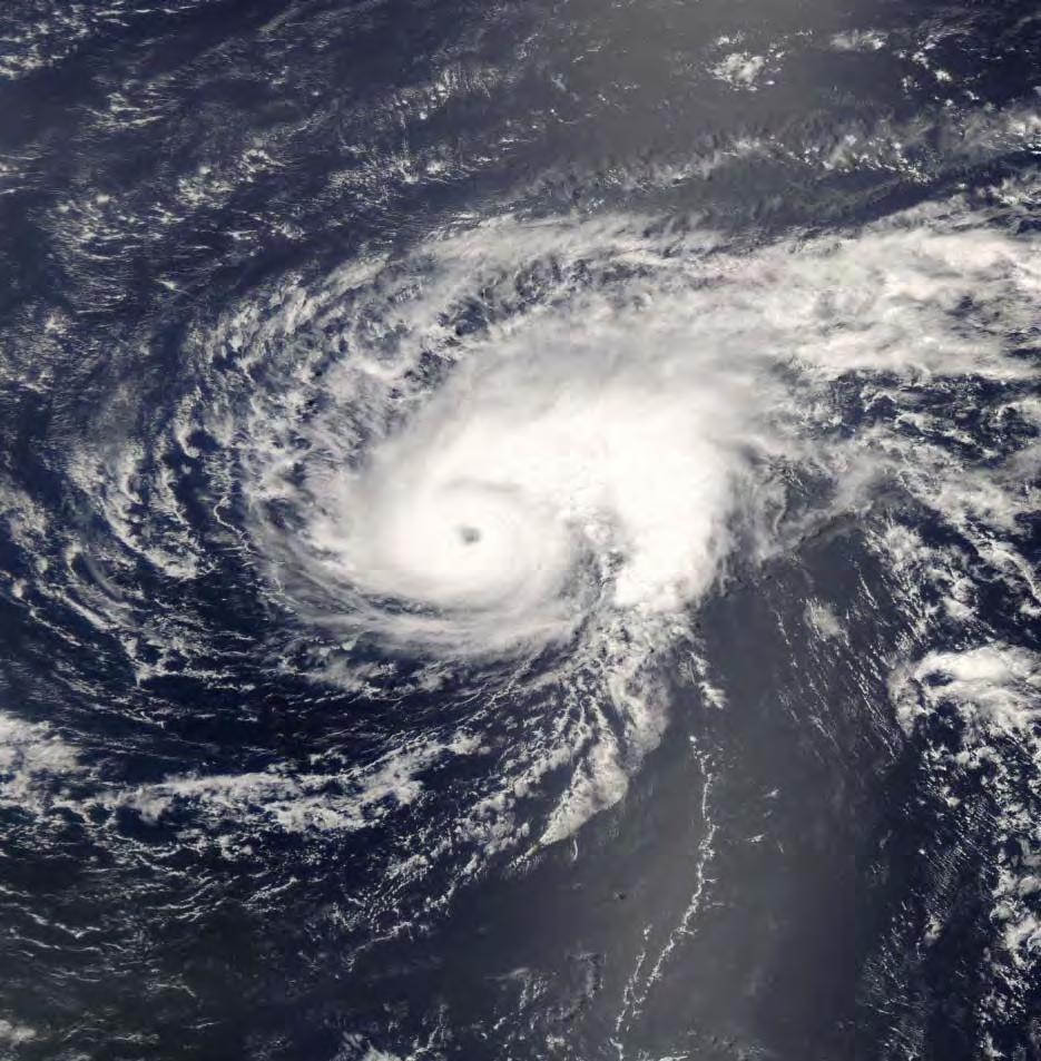
26 2012 Season in Review Hurricane Isaac

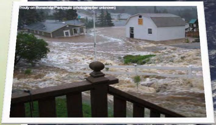
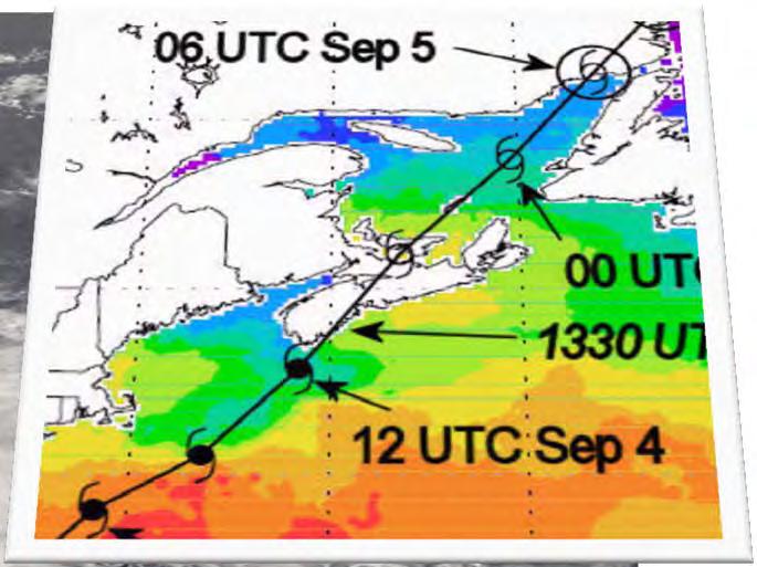
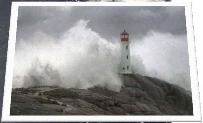
27 2012 Season in Review Hurricane Leslie Leslie formed in early September Spent a prolonged period of time moving very slowly northward Leslie finally began to approach Atlantic Canada on September 9 th On September 11th, the storm tracked into eastern Newfoundland as a hurricane-force Post- Tropical Storm

28 2012 Season in Review Hurricane Leslie Also a front stalled over Nova Scotia as it approached Leslie. Moisture converging along the front streamed across central Nova Scotia
29 2012 Season in Review Hurricane Leslie Truro, NS


30 2012 Season in Review Hurricane Rafael No significant impact over land other than large swell and rapid water level fluctuations


31 2012 Season in Review Hurricane Sandy Post-Trop Post-Trop Transition Transition Transition Transition Tropical Tropical Tropical Tropical


32 2012 Season in Review Hurricane Sandy Wind warnings were posted for many areas of southern Canada specifically in Ontario and along the St. Lawrence River in Quebec Sandy s circulation while in the Post- Tropical phase exceeded 1600 km, extending from the U.S South to Atlantic Canada and as far west as Wisconsin Major to record storm surge with catastrophic damage along large portions of the New Jersey, New York, Connecticut, Rhode Island and Massachusetts coasts 147 direct fatalities from the Caribbean up to Canada Over $74 billion property damage Nearly 9 million homes lost power some outages lasted weeks Recovery is STILL ongoing!

33 Patterns affecting Sandy s track Strong area of high pressure over the North Atlantic essentially created a blocking pattern preventing Sandy from following a more conventional track
34 Sandy s Track
35 Sandy s Track

36 Sandy s Track

37 Sandy s Landfall Sandy made landfall as a post-tropical cyclone near Brigantine, New Jersey


38 Sandy s Extreme Weather Sandy s Winds Strongest to the right of track Sandy s Rainfall Heaviest to the left of track Sandy s Snowfall
39 Sandy s Impacts Peak surge was about 3 m

40 2012 Season in Review Hurricane Sandy New York s Costliest Disasters to Date (FEMA Public Assistance Costs)
41 Sandy s Impacts


42 Sandy s Impacts
43 Sandy s Impacts


44 Sandy s Impacts Sandy s Impacts in Canada Sarnia, ON hotel roof Toronto, ON awning collapse

45 Warning Challenges Weather a storm is Tropical or Post Tropical has major operational implications Operational handling of cyclone types requires a yes or no response - tropical cyclone (TC) warnings or non-tropical wind warnings It also has major insurance implications in the U.S. NHC (Miami) procedures prevented them from issuing tropical warnings for post-tropical storms Their procedures have been changed this year and are now aligned with those at the Canadian Hurricane Center 45
46 2012 Season in Review Hurricane Sandy Why Post-Tropical Storm Sandy is Important for Eastern Canada The main factor affecting intensity at landfall was no longer the warm water temperature but rather the horizontal air temperature difference This means that a storm like Sandy could just as easily track up towards Atlantic Canada as it did into New Jersey This would represent a worst-case scenario of sorts for eastern Canada: Late season hurricane becoming post-tropical south of Atlantic Canada Cold front or trough of low pressure to the west Re-intensification as a Post-Tropical Storm and the storm increasing in size


47 2012 Season in Review Hurricane Sandy Other interesting facts about Sandy Sandy was an unprecedented storm for the Canadian Hurricane Centre from a communications standpoint NY 911 Call Centre received 20,000 calls per hour at the peak Residents had difficulty getting through an resorted to social media 911 Call Centre had people taking Twitter Emergency Calls Hurricane Sandy dumped 11billion gallons of raw sewage in eastern US waterways Waves generated by Sandy hitting each other and the shore rattled the seafloor and much of the United States - shaking was detected by seismometers across the country
48 Operational Response to Hurricanes Time (HR:MM) (Eastern time) Forecast/Business Cycle at the CHC Event or Task 8:00 am Issue CHC Hurricane Information Statement, Technical Bulletin and the forecast track map Update any Tropical Warnings 8:15 am Emergency Management Briefings (if necessary) 9:00 am Federal GOC Briefing (if necessary) 10:00 am Internal coordination call 11:00 pm Transmit intermediate bulletin (if necessary) Prepare material for media briefing Review NHC updated advisory Review new model guidance 12:00 pm Media technical media briefing 1:00 pm Blackout period for the media Intermediate consultation with emergency managers 2:00 pm New cycle begins


49 Operational Response to Hurricanes CHC Website Public Bulletin Non technical language Intended for the public Technical Bulletin More technical details Intended for other weather centres

50 Operational Response to Hurricanes


51 Operational Response to Hurricanes Hurricane Position Forecast Errors Avg. Position Error 72 hrs 237 km 48 hrs 170 km 24 hrs 96 km Track error has diminished by about 8% from 2012


 Size of the circles")


52 Operational Response to Hurricanes Common Misconception Track Forecast Represents the probable track of the center of the tropical cyclone Track error cone is formed by connecting circles centered on each forecast point (at 12, 24, 36 h, etc.) Size of the circles are determined so that the actual storm position at a certain time will be within the corresponding circle 67% of the time


53 Operational Response to Hurricanes Seasonal Media Briefing CHC holds pre-seasonal briefings timed with the release of the NOAA Hurricane Season Forecast Used primarily to explain what the NOAA numbers mean for Canada and to promote preparedness Emergency management officials typically invited to speak to enhance the preparedness messages Storm Specific Media Briefings Generally held for higher impact storms Start 3-4 days prior to storm s arrival In-person briefing to explain what the storm is doing and what is expected Typically held in the afternoon


54 Operational Response to Hurricanes Emergency Management Seasonal Briefing Cover the basics of tropical cyclones and how they affect Canada, review of previous year and outlook for the current year Review of the established operational practices used during actual storms Typically held around the start of the season Occasionally we will deliver a full-day or ½-day training session Emergency Management Storm Briefing Briefing held by the CHC for provincial EMO and PS representatives Key step in the coordinated approach to getting the latest information on the storm to key emergency management officials These briefings are held using WebEx


55 Operational Response to Hurricanes 1. General update on the storm with potential impacts 2. Briefing usually 15 minutes plus time for questions and discussion 3. Total time minutes 4. WPMs also take in the briefing Emergency Management Briefings Canadian Hurricane Centre Morning Briefing (0915 AT) (Robichaud/Fogarty) WebEx Government Operations Centre Ottawa Held at the request of any EM agency OR when CHC deems appropriate Nova Scotia EMO & PSC Newfoundland and Labrador FES & PSC Prince Edward Island Office of Public Safety & PSC New Brunswick EMO & PSC Other affected Provinces


56 Operational Response to Hurricanes Provincial Emergency Management Briefings Nova Scotia EMO and WPM NS Response agencies Municipalities Provincial Departments Critical Infrastructure Newfoundland and Labrador FES and WPM NL Response agencies Municipalities Provincial Departments Critical Infrastructure PEI Office of Public Safety and WPM PEI Response agencies Municipalities Provincial Departments Critical Infrastructure New Brunswick EMO and WPM NB Response agencies Municipalities Provincial Departments Critical Infrastructure

57 Operational Response to Hurricanes Use caution when interpreting model track forecasts! Models Track forecast based on lowlevel steering winds caused concern It was known to forecasters that Sandy would be steered by mid and high level winds not lowlevel winds resulting in this track being rejected About 35 different track models Some of these models will provide more than one possibility Some models simply do not apply under certain situations


58 Operational Response to Hurricanes New and Upcoming Tools Shape files are produced by the Canadian Hurricane Centre to be ingested into GIS applications Can also be viewed using Google Earth


59 Operational Response to Hurricanes Social Media Using Twitter more this year to point to updates in the hurricane status Experimenting with YouTube to post short updates on active storms approaching


60
61 2013 Atlantic Hurricane Forecast Named Storms Hurricanes Category 1 to 5 Major Hurricanes Category 3-5 National Oceanic and Atmospheric Administration (US) Average Average or 3

62 Latest Sea Surface Temperature Patterns Warmer than normal sea surface temperature Water temperatures are higher than normal in the main storm formation region of the tropical Atlantic Ocean.


63 Number of Storms per Year
64 List of Atlantic Storm Names Andrea Arthur Ana Alex Arlene Alberto Barry Bertha Bill Bonnie Bret Beryl Chantal Cristobal Claudette Colin Cindy Chris Dorian Dolly Danny Danielle Don Debby Erin Edouard Erika Earl Emily Ernesto Fernand Fay Fred Fiona Franklin Florence Gabrielle Gonzalo Grace Gaston Gert Gordon Humberto Hanna Henri Hermine Harvey Helene Ingrid Isaias Ida Ian Irma Isaac Jerry Josephine Joaquin Julia Jose Joyce Karen Kyle Kate Karl Katia Kirk Lorenzo Laura Larry Lisa Lee Leslie Melissa Marco Mindy Matthew Maria Michael Nestor Nana Nicholas Nicole Nate Nadine Olga Omar Odette Otto Ophelia Oscar Pablo Paulette Peter Paula Philippe Patty Rebekah Rene Rose Richard Rina Rafael Sebastien Sally Sam Shary Sean Sara* Tanya Teddy Teresa Tobias Tammy Tony Van Vicky Victor Virginie Vince Valerie Wendy Wilfred Wanda Walter Whitney William * Sandy was replaced with Sara


65 BE CAREFUL WHAT YOU EXERCISE! Emergency management officials conducted and exercise involving Hurricane Gispert Strong hurricane about to make landfall on Tampa in the middle of the republican convention with 70,000 new visitors in the storm's path.


66 BE CAREFUL WHAT YOU EXERCISE! On August 27 th strengthening Tropical Storm Isaac tracked just west of Tampa producing strong winds and heavy rain


67 BE CAREFUL WHAT YOU EXERCISE! In October 1997, emergency management officials in New York ran a hurricane simulation The fictional storm was loosely based on the 1938 Long Island Express Hurricane which produced devastating storm surge and wind damage The practice hurricane was set to come inland on in the evening hours with hurricane-force winds Can you guess the name of the fictional storm?


68
69 Hurricane Juan Retrospective Before After No tropical type watches or warnings CHC handled media requests as they came in There was no formal response to the seasonal tropical outlook CHC now has the ability to issue tropical-type watches and warnings CHC now holds media technical briefings during the larger events The CHC now coordinates a formal response to the seasonal forecast by holding a media technical briefing and engaging emergency management partners Media would come into the operational area to conduct interviews and take B-roll MSC now has a media room designed for these types of interviews and other media related activities Two landfalling hurricanes in Nova Scotia in the ten years prior to Juan Two landfalling hurricanes in Nova Scotia in the ten years after Juan CHC used to be on the 19 th floor of Queen Square in Dartmouth Canada had never requested a tropical cyclone name be retired Typical forecast track errors for 72, 48 and 24 hours were 140 nm, 115 nm and 72 nm respectively No emergency management-specific hurricane training was available CHC is now on the 3 rd floor Two tropical cyclone names have been retired at Canada s request: Juan and Igor Typical forecast track error for 72, 48 and 24 hours are now 128 nm, 92 nm and 52 nm respectively Weather related training is now available to emergency management agencies which includes extensive hurricane related info Any emergency management-specific hurricane briefings were strictly on an ad-hoc basis The CHC now coordinates and hosts emergency management hurricane briefings at the beginning of the season and during real-time events. During severe events a trained MSC meteorologist may relocated to an EOC for direct support (e.g. Kyle, Earl)
70 Thank you! Bob Robichaud Warning Preparedness Meteorologist Canadian Hurricane Centre Dartmouth, NS Tel:
Understanding Hurricanes. Kieran Bhatia
 Understanding Hurricanes Kieran Bhatia Why do we care? What are they? When should we be ready? Why aren t forecasts perfect? If a hurricane makes landfall, what should we expect? Tropical cyclones have
Hurricanes and Global Climate Change
 Key Concepts: Greenhouse Gas Cyclone El Niño Hurricane IPCC La Niña Saffir-Simpson Scale Storm surge Typhoon WHAT YOU WILL LEARN 1. You will learn the difference between hurricanes, typhoons, and cyclones.
TROPICS. The Tropics. What are Tropical Cyclones? Atlantic Hurricane Season The official Atlantic hurricane season is from June 1 to November 30
 Hurricanes: Formation Mechanisms, Forecasting, and Impacts in North Carolina The Tropics Located 23½ N to 23½ S TROPICS Dr. Christopher M. Godfrey Associate Professor Department of Atmospheric Sciences
Tropical Cyclones. Part 10
 Tropical Cyclones Part 10 What is a Tropical Cyclone? A tropical cyclone is the general term for all rotating weather systems that originate over warm tropical waters. Tropical cyclones are classified
Hurricanes. GEOG/ENST 2331 Lecture 18 Ahrens: Chapter 14. Figure to right Atlantic Hurricanes: 2017
 Hurricanes GEOG/ENST 2331 Lecture 18 Ahrens: Chapter 14 Figure to right Atlantic Hurricanes: 2017 Western Pacific Typhoons: 2017 Hurricanes Tropical cyclones Dynamics Formation Structure Movement Dissipation
Canadian Hurricane Center: How NHC Products are used to issue Warnings and Communicate Hazards
 Canadian Hurricane Center: How NHC Products are used to issue Warnings and Communicate Hazards Bob Robichaud Warning Preparedness Meteorologist Canadian Hurricane Centre Contents Brief background on the
HURRICANES. Part 1/Group 1 Student Handout Historical Occurrence Study 2. Part 2/Group2 Student Handout Storm Tracking 5
 LEARNING EXPERIENCE 1 STUDENT HANDOUT HURRICANES Developed by Rebecca C. Smyth 1, Matt Morris 2,3 and Kathy Ellins 4 1. Research Scientist Associate, Bureau of Economic Geology, Jackson School of Geosciences,
HURRICANES. The History, Structure, Development, and Destruction. Source:
 HURRICANES The History, Structure, Development, and Destruction Source: http://www.dc.peachnet.edu/~pgore/students/w97/matheson/hpage.htm Hurricane Sandy was the deadliest and most destructive tropical
An Assessment of the Climatology of Florida Hurricane-Induced Tornadoes (HITs): Technology versus Meteorology
: Technology versus Meteorology") 5218 J O U R N A L O F C L I M A T E VOLUME 24 An Assessment of the Climatology of Florida Hurricane-Induced Tornadoes (HITs): Technology versus Meteorology ERNEST M. AGEE AND ALYSSA HENDRICKS Department
5218 J O U R N A L O F C L I M A T E VOLUME 24 An Assessment of the Climatology of Florida Hurricane-Induced Tornadoes (HITs): Technology versus Meteorology ERNEST M. AGEE AND ALYSSA HENDRICKS Department
The 2014 Atlantic Hurricane Season. What is New and What to Expect. Mark Chambers President & CEO ImpactWeather, Inc.
 The 2014 Atlantic Hurricane Season What is New and What to Expect Mark Chambers President & CEO ImpactWeather, Inc. Hurricane Climatology for the Gulf of Mexico A Look back at 2013 The outlook for this
A hurricane is a. Low pressure, tropical cyclone, over warm water Winds exceeding 74 mph Winds move counterclockwise and inward.
 Topic: Hurricanes Astronaut Douglas Wheelock aboard the International Space Station (ISS) caught this image of the eye of the storm as the ISS flew over Hurricane Earl just to the east on Sept. 3. Wheelock
HURRICANE SURVIVAL KIT
 HURRICANE SURVIVAL KIT DEFINITION-A hurricane is a very vast and powerful storm that originates in the tropics of the Atlantic Ocean. They become hurricanes when the sustained winds associated with it
City of Punta Gorda Community Emergency Management Plan 2013
 City of Punta Gorda Community Emergency Management Plan 2013 Hurricane Andrew- August 24, 1992 Category 5 hurricane. The second-most-destructive hurricane in U.S. history. The first named storm of the
Frank Revitte National Weather Service. Weather Forecast Office New Orleans/Baton Rouge
 Frank Revitte National Weather Service Weather Forecast Office New Orleans/Baton Rouge Above normal activity 17 Total Named Storms 7 Tropical Storms 4 Hurricanes 6 Major Hurricanes Not the most active,
2015 Hurricane Season Summary for Eastern Canada Impacts and Operational Notes
 2015 Hurricane Season Summary for Eastern Canada Impacts and Operational Notes John Parker Canadian Hurricane Centre, Meteorological Service of Canada April, 2016 Storms affecting Canadian territory in
Tropical Update. 5 PM EDT Tuesday, September 5, 2017 Hurricane Irma, Tropical Storm Jose, and Tropical Depression Thirteen
 Tropical Update 5 PM EDT Tuesday, September 5, 2017 Hurricane Irma, Tropical Storm Jose, and Tropical Depression Thirteen This update is intended for government and emergency response officials, and is
2012 Hurricane Season Summary for Eastern Canada Impacts and Operational Notes
 2012 Hurricane Season Summary for Eastern Canada Impacts and Operational Notes John Parker and Chris Fogarty Canadian Hurricane Centre, Meteorological Service of Canada 2 April 2013 Storms affecting Canadian
Hurricanes. Hurricanes LEVELED BOOK W. Visit for thousands of books and materials.
 Hurricanes A Reading A Z Level W Leveled Book Word Count: 1,715 LEVELED BOOK W Hurricanes Written by Shaun Taylor Visit www.readinga-z.com for thousands of books and materials. www.readinga-z.com Hurricanes
A summary of recent notable ET events over Eastern Canada. IWET4 - May 2012 Chris Fogarty Canadian Hurricane Center
 A summary of recent notable ET events over Eastern Canada IWET4 - May 2012 Chris Fogarty Canadian Hurricane Center Canadian Hurricane Center Response Zone On average, 1 or 2 storms directly affect Canadian
Tropical Update. 11 AM EDT Tuesday, October 9, 2018 Hurricane Michael, Tropical Storm Leslie, Tropical Storm Nadine
 Tropical Update 11 AM EDT Tuesday, October 9, 2018 Hurricane Michael, Tropical Storm Leslie, Tropical Storm Nadine This update is intended for government and emergency response officials, and is provided
Tropical Update. 5 AM EDT Wednesday, September 6, 2017 Hurricane Irma, Tropical Storm Jose, and Tropical Storm Katia
 Tropical Update 5 AM EDT Wednesday, September 6, 2017 Hurricane Irma, Tropical Storm Jose, and Tropical Storm Katia This update is intended for government and emergency response officials, and is provided
Tropical Update. 5 AM EDT Monday, October 8, 2018 Tropical Storm Michael, Tropical Storm Leslie, Invest 92L (10%) & African Tropical Wave (50%)
 & African Tropical Wave (50%)") Tropical Update 5 AM EDT Monday, October 8, 2018 Tropical Storm Michael, Tropical Storm Leslie, Invest 92L (10%) & African Tropical Wave (50%) This update is intended for government and emergency response
Tropical Update 5 AM EDT Monday, October 8, 2018 Tropical Storm Michael, Tropical Storm Leslie, Invest 92L (10%) & African Tropical Wave (50%) This update is intended for government and emergency response
Hurricane Preparedness and Awareness!
 Hurricane Preparedness and Awareness! Check these out Time to begin executing the evacuation plan What kind of damage are we talking about here? What Exactly Is a Hurricane? A hurricane can best be described
Marc Ferguson Calcasieu Parish Office of Homeland Security & Emergency Preparedness
 HURRICANE PREPAREDNESS Marc Ferguson Calcasieu Parish Office of Homeland Security & Emergency Preparedness 2015 Colorado Terms To Know State University Hurricane Outlook Tropical Depression Tropical Storm
The Wind Hazard: Messaging the Wind Threat & Corresponding Potential Impacts
 The Wind Hazard: Messaging the Wind Threat & Corresponding Potential Impacts Scott Spratt Warning Coordination Meteorologist NWS Melbourne, FL David Sharp Science & Operations Officer NWS Melbourne, FL
GC Briefing. Weather Sentinel Tropical Storm Michael. Status at 8 AM EDT (12 UTC) Today (NHC) Discussion. October 11, 2018
 Today (NHC) Discussion. October 11, 2018") GC Briefing Weather Sentinel Tropical Storm Michael October 11, 2018 After making landfall as a high-end category-4 hurricane on the Florida Panhandle, Michael weakened to tropical storm status early this
GC Briefing Weather Sentinel Tropical Storm Michael October 11, 2018 After making landfall as a high-end category-4 hurricane on the Florida Panhandle, Michael weakened to tropical storm status early this
ovember 2008 Antigua and Barbuda Meteorological Service
 ovember 2008 Antigua and Barbuda Meteorological Service The Atlantic Hurricane Season Summary 2008 Special Focus on Antigua and Barbuda The Season in Brief Sixteen (16) named storms formed in the Atlantic
GC Briefing. Weather Sentinel Hurricane Florence. Status at 5 PM EDT (21 UTC) Today (NHC) Discussion. September 13, 2018
 Today (NHC) Discussion. September 13, 2018") GC Briefing September 13, 2018 Weather Sentinel Hurricane Florence Tropical storm conditions have been reported for areas of North Carolina and will continue to spread inland to the west and south. Hurricane
GC Briefing September 13, 2018 Weather Sentinel Hurricane Florence Tropical storm conditions have been reported for areas of North Carolina and will continue to spread inland to the west and south. Hurricane
Tropical Update. 5 PM EDT Thursday, September 7, 2017 Hurricane Irma, Hurricane Jose, and Hurricane Katia
 Tropical Update 5 PM EDT Thursday, September 7, 2017 Hurricane Irma, Hurricane Jose, and Hurricane Katia This update is intended for government and emergency response officials, and is provided for informational
Tropical Update. 5 AM EDT Thursday, September 7, 2017 Hurricane Irma, Hurricane Jose, and Hurricane Katia
 Tropical Update 5 AM EDT Thursday, September 7, 2017 Hurricane Irma, Hurricane Jose, and Hurricane Katia This update is intended for government and emergency response officials, and is provided for informational
NWS HURRICANES June 3, 2015
 NWS HURRICANES June 3, 2015 Hurricane Season June 1 November 30 2 What s the concern? All tropical systems passing within 125nm of central Maryland since 1950 Mid-Atlantic Hurricanes Greatest Risk: August
Tropical Update. 5 PM EDT Sunday, October 7, 2018 Tropical Storm Michael, Tropical Storm Leslie, & Invest 92L (30%)
") Tropical Update 5 PM EDT Sunday, October 7, 2018 Tropical Storm Michael, Tropical Storm Leslie, & Invest 92L (30%) This update is intended for government and emergency response officials, and is provided
Tropical Update 5 PM EDT Sunday, October 7, 2018 Tropical Storm Michael, Tropical Storm Leslie, & Invest 92L (30%) This update is intended for government and emergency response officials, and is provided
Tropical Update. 5 PM EDT Sunday, September 10, 2017 Hurricane Irma, Hurricane Jose, Tropical Wave (60%)
") Tropical Update 5 PM EDT Sunday, September 10, 2017 Hurricane Irma, Hurricane Jose, Tropical Wave (60%) This update is intended for government and emergency response officials, and is provided for informational
Tropical Update 5 PM EDT Sunday, September 10, 2017 Hurricane Irma, Hurricane Jose, Tropical Wave (60%) This update is intended for government and emergency response officials, and is provided for informational
National Hurricane Center Products. Jack Beven National Hurricane Center
 National Hurricane Center Products Jack Beven National Hurricane Center Florida Governor s Hurricane Conference 11 May 2014 NHC Tropical Cyclone Products NHC provides the big picture that complements and
At the Midpoint of the 2008
 At the Midpoint of the 2008 Atlantic Hurricane Season Editor s note: It has been an anxious couple of weeks for those with financial interests in either on- or offshore assets in the Gulf of Mexico and
Exercise Brunswick ALPHA 2018
 ALPHA Exercise Brunswick ALPHA 2018 Who we are (our structure) What we do (our forecasts) How you can access the information Tropical cyclone information (basic) Overview of the products used for Exercise
Major Hurricane Matthew Briefing Situation Overview
 Major Hurricane Matthew Briefing Situation Overview THIS IS NOW A WORST CASE STORM SURGE SCENARIO Catastrophic Damage is Anticipated for Coastal Areas. Major Hurricane Matthew is still expected to move
Tropical Update. 11 AM EDT Wednesday, October 10, 2018 Hurricane Michael, Hurricane Leslie & Tropical Storm Nadine, Caribbean Low (40%)
") Tropical Update 11 AM EDT Wednesday, October 10, 2018 Hurricane Michael, Hurricane Leslie & Tropical Storm Nadine, Caribbean Low (40%) This update is intended for government and emergency response officials,
Tropical Update 11 AM EDT Wednesday, October 10, 2018 Hurricane Michael, Hurricane Leslie & Tropical Storm Nadine, Caribbean Low (40%) This update is intended for government and emergency response officials,
Chapter 24 Tropical Cyclones
 Chapter 24 Tropical Cyclones Tropical Weather Systems Tropical disturbance a cluster of thunderstorms about 250 to 600 km in diameter, originating in the tropics or sub-tropics Tropical depression a cluster
2 nd. Annual FDOT District Two Traffic Incident Management Team HURRICANE PREPAREDNESS NEWSLETTER
 2 nd Annual FDOT District Two Traffic Incident Management Team HURRICANE PREPAREDNESS NEWSLETTER CCTV camera image of Tropical Storm Colin as it was moving through the Jacksonville area on June 6, 2016
2017 Annual Hurricane. Preparedness. Welcome Navy Tropical Information History 2017 Forecast Evacuation Duncan St - Sep 2004.
 2017 Annual Hurricane Preparedness Welcome Navy Tropical Information History 2017 Forecast Evacuation Duncan St - Sep 2004 Preparedness (looking south from front gate) Conditions of Readiness (CORs) Hurricane
Very Dangerous Coastal Storm Sandy October 28 th 31 st 2012
 Very Dangerous Coastal Storm Sandy October 28 th 31 st 2012 Prepared 600 PM EDT Monday October 29, 2012 Gary Szatkowski NOAA s NJ Forecast Office Weather.gov/phi Purpose of Briefing Briefing #11 for event
Tropical Storm Harvey: SE Texas Impacts
 Tropical Storm Harvey: SE Texas Impacts 10 AM CDT UPDATE Thursday, August 24, 2017 Prepared by: Dan Reilly, Brian Kyle PLEASE MUTE YOUR LINES AND DON T PUT ON HOLD! Situation Overview Tropical Storm Harvey
Hurricane Sandy October 28 th 31 st 2012
 Hurricane Sandy October 28 th 31 st 2012 Prepared 530 PM EDT Saturday October 27, 2012 Gary Szatkowski NOAA s NJ Forecast Office Weather.gov/phi Purpose of Briefing Briefing #7 for event Promote situational
LECTURE #18: Hurricane Damage, Monitoring & Case Study
 GEOL 0820 Ramsey Natural Disasters Spring, 2018 LECTURE #18: Hurricane Damage, Monitoring & Case Study Date: 27 March 2018 I. Exam II grades now posted online o high: 98, low: 46, average: 80 (~3 points
Tropical Update. 5 AM EDT Tuesday, September 12, 2017 Post-Tropical Cyclone Irma, Hurricane Jose, & Tropical Wave (10%)
") Tropical Update 5 AM EDT Tuesday, September 12, 2017 Post-Tropical Cyclone Irma, Hurricane Jose, & Tropical Wave (10%) This update is intended for government and emergency response officials, and is provided
Tropical Update 5 AM EDT Tuesday, September 12, 2017 Post-Tropical Cyclone Irma, Hurricane Jose, & Tropical Wave (10%) This update is intended for government and emergency response officials, and is provided
Are You Ready For Hurricane Season? 2018 Hurricane Talk B Y : S T O R M T E A M 8 M E T E O R O L O G I S T J U L I E P H I L L I P S
 Are You Ready For Hurricane Season? 2018 Hurricane Talk B Y : S T O R M T E A M 8 M E T E O R O L O G I S T J U L I E P H I L L I P S About Me I am Currently a Weekday Meteorologist at WFLA Channel 8.
Continuity in the Face of Hurricanes: What Every Business Needs To Know. Cameron Self, Tropical Meteorologist. StormGeo
 Continuity in the Face of Hurricanes: What Every Business Needs To Know Cameron Self, Tropical Meteorologist. StormGeo A Hurricane is a Big Heat Engine Forming over warm tropical waters, wind speeds range
Storm Summary for Hurricane Jose
 Storm Summary for Hurricane Jose Tuesday, September 19, 2017 at 11 AM EDT (Output from Hurrevac, based on National Hurricane Center Forecast Advisory #57) Jose is currently a Category 1 hurricane on the
2017 Hurricane Season and Beyond
 2017 Hurricane Season and Beyond Ken Graham National Hurricane Center Building a Weather-Ready Nation Much of U.S. Coast Saw Tropical Wind Watches or Warnings 2017 Hurricane Season Facts and Figures 7th
Outlook 2008 Atlantic Hurricane Season. Kevin Lipton, Ingrid Amberger National Weather Service Albany, New York
 Outlook 2008 Atlantic Hurricane Season Kevin Lipton, Ingrid Amberger National Weather Service Albany, New York Summary 2007 Hurricane Season Two hurricanes made landfall in the Atlantic Basin at category-5
2006 ATLANTIC HURRICANE SUMMARY. Weather Research Center Houston, Texas
 2006 ATLANTIC HURRICANE SUMMARY Weather Research Center Houston, Texas Weather Research Center 5104 Caroline Houston, Texas 77004 Phone: 713-529-3076 Fax: 713-528-3538 E-mail: wrc@wxresearch.org 2006 Atlantic
Atlantic Basin Satellite Image
 Tropical Update 11 AM EDT Friday, September 7, 2018 Tropical Depression Gordon, Tropical Storm Florence, Potential Tropical Cyclone #8 (90%), Invest 92L (90%) This update is intended for government and
& ~ Hurricane Season Review ~
 & ~ Hurricane Season Review ~ St. Maarten experienced drought conditions in 2016 with no severe weather events. All Photos compliments Paul G. Ellinger Meteorological Department St. Maarten Airport Rd.
RSMC-Miami Update Daniel Brown Warning Coordination Meteorologist
 RSMC-Miami Update 2016 Daniel Brown Warning Coordination Meteorologist L-0324 Emergency Management Hurricane Preparedness Training Course Funding provided by FEMA s National Hurricane Program - partnership
Hurricanes. Hurricanes are large, tropical storm systems that form and develop over the warm waters near the equator.
 Hurricanes Hurricanes are large, tropical storm systems that form and develop over the warm waters near the equator. They are responsible for weather that can devastate entire communities: Heavy rain --
(April 7, 2010, Wednesday) Tropical Storms & Hurricanes Part 2
 Tropical Storms & Hurricanes Part 2") Lecture #17 (April 7, 2010, Wednesday) Tropical Storms & Hurricanes Part 2 Hurricane Katrina August 2005 All tropical cyclone tracks (1945-2006). Hurricane Formation While moving westward, tropical disturbances
Lecture #17 (April 7, 2010, Wednesday) Tropical Storms & Hurricanes Part 2 Hurricane Katrina August 2005 All tropical cyclone tracks (1945-2006). Hurricane Formation While moving westward, tropical disturbances
Careful, Cyclones Can Blow You Away!
 Title: Careful, Cyclones Can Blow You Away! (Meteorology) Grade(s): 6-8 Introduction: Most people associate twisters with tornadoes, but in fact tropical twisters come from hurricanes. Hurricanes are what
HURRICANE PLANNING GUIDE
 UNIVERSITY OF HOUSTON HURRICANE PLANNING GUIDE Guidelines for Hurricane Planning and Response 2014 UNIVERSITY OF HOUSTON A Carnegie-Designated Tier One Public Reasearch University 1 OFFICE OF EMERGENCY
MUNICIPALITY OF THE DISTRICT OF WEST HANTS Committee of the Whole Agenda July 25, :00p.m. Sanford Council Chambers
 MUNICIPALITY OF THE DISTRICT OF WEST HANTS Committee of the Whole Agenda July 25, 2017 6:00p.m. Sanford Council Chambers 1. Call to Order 2. Announcements 3. Approval of Agenda, including additions or
WEDNESDAY 30 TH AUGUST, :57 p.m. Tropical Storm Irma forms in the Atlantic. Don t let your guard down, always #Be Ready.
 Chapter 1 - The Set Up In the days leading up to Irma a series of composed and sobering text messages, presented in truncated form below, from Department of Disaster Management warned us of the pending
Chapter 11 Hurricanes
 Natural Disasters Tenth Edition Chapter 11 Hurricanes Copyright The McGraw-Hill Companies, Inc. Permission required for reproduction or display. 11-1 Hurricanes Large tropical cyclones Heat engines converting
HURRICANE PLANNING GUIDE
 UNIVERSITY OF HOUSTON HURRICANE PLANNING GUIDE Guidelines for Hurricane Planning and Response 2015 UNIVERSITY OF HOUSTON A Carnegie-Designated Tier One Public Reasearch University 1 OFFICE OF EMERGENCY
A Look Back at the 2012 Hurricane Season and a Look Ahead to 2013 & Beyond. Daniel Brown National Hurricane Center Miami, Florida 24 April 2013
 A Look Back at the 2012 Hurricane Season and a Look Ahead to 2013 & Beyond Daniel Brown National Hurricane Center Miami, Florida 24 April 2013 2012 Atlantic Verification Good News- Lots of Accuracy Records
Case Studies in Communication Challenges: Hurricane Sandy
 Case Studies in Communication Challenges: Hurricane Sandy International Workshop on Tropical Cyclones Jeju Island, South Korea Chris Landsea, National Hurricane Center, RSMC Miami Major Hurricane Sandy
Tropical Update 11 AM EDT Thursday, September 6, 2018 Tropical Depression Gordon, Hurricane Florence, Invest 92L (90%) & African Tropical Wave (50%)
 & African Tropical Wave (50%)") Tropical Update 11 AM EDT Thursday, September 6, 2018 Tropical Depression Gordon, Hurricane Florence, Invest 92L (90%) & African Tropical Wave (50%) This update is intended for government and emergency
Tropical Update 11 AM EDT Thursday, September 6, 2018 Tropical Depression Gordon, Hurricane Florence, Invest 92L (90%) & African Tropical Wave (50%) This update is intended for government and emergency
ESCI 241 Meteorology Lesson 19 Tropical Cyclones Dr. DeCaria
 ESCI 241 Meteorology Lesson 19 Tropical Cyclones Dr. DeCaria READING: Chapter 16 GENERAL A tropical cyclone is a large, low-pressure system that forms over the tropical oceans. Tropical cyclones are classified
Tropical Update. 12 PM EDT Friday, October 7, 2016 Hurricane Matthew & Tropical Storm Nicole
 Tropical Update 12 PM EDT Friday, October 7, 2016 Hurricane Matthew & Tropical Storm Nicole This update is intended for government and emergency response officials, and is provided for informational and
ARUBA CLIMATOLOGICAL SUMMARY 2017 PRECIPITATION
 ARUBA CLIMATOLOGICAL SUMMARY 2017 PRECIPITATION The total amount of rainfall recorded at Reina Beatrix International Airport for the year 2017 was 391.0 mm. This is 17.1 % below normal ( Figure 1 ). During
HURRICANE IRENE. CONFERENCE CALL BRIEFING SLIDES Saturday August 27, :30 AM
 HURRICANE IRENE CONFERENCE CALL BRIEFING SLIDES Saturday August 27, 2011 8:30 AM NHC TRACK AND CONE HURRICANE IRENE WATCHES/WARNINGS Hurricane Warning along south coast including all of Cape Cod and Islands
Ch. 11: Hurricanes. Be able to. Define what hurricane is. Identify the life and death of a hurricane. Identify the ways we track hurricanes.
 Ch. 11: Hurricanes Be able to Define what hurricane is. Identify the life and death of a hurricane. Identify the ways we track hurricanes. What are Hurricanes? Smaller than mid-latitude cyclones. Don t
Storm Summary for Hurricane Joaquin
 Storm Summary for Hurricane Joaquin Wednesday, September 30, 2015 at 5 PM EDT (Output from Hurrevac, based on National Hurricane Center Forecast Advisory #12) Joaquin is currently a Category 1 hurricane
Weather forecasts and warnings: Support for Impact based decision making
 Weather forecasts and warnings: Support for Impact based decision making Gerry Murphy, Met Éireann www.met.ie An Era of Change Climate and weather is changing Societal vulnerability is increasing The nature
Prolonged Coastal Storm October 9 th -12 th, 2013
 Prolonged Coastal Storm October 9 th -12 th, 2013 Prepared 400 PM EDT Tuesday, October 8th, 2013 Gary Szatkowski NOAA s NJ Forecast office http://www.erh.noaa.gov/phi/ Purpose of Briefing Briefing #1 for
COLORADO STATE UNIVERSITY FORECAST OF ATLANTIC HURRICANE ACTIVITY FROM AUGUST 31 SEPTEMBER 13, 2012
 COLORADO STATE UNIVERSITY FORECAST OF ATLANTIC HURRICANE ACTIVITY FROM AUGUST 31 SEPTEMBER 13, 2012 We expect that the next two weeks will be characterized by average amounts (70-130 percent) of activity
National Situation Report As of 3:00 a.m. EDT, Thursday, September 21, 2017 Table of Contents Current Operations Monitoring Recovery
 25k Overview National Situation Report As of 3:00 a.m. EDT, Thursday, September 21, 2017 Table of Contents Current Operations Monitoring Recovery FEMA Headquarters Status FEMA Region Status NRCC Level
HURRICANE HARVEY COE Navigation BRIEFING
 HURRICANE HARVEY COE Navigation BRIEFING 10:00 AM CDT Friday, August 25, 2017 NWSNewOrleans www.weather.gov/neworleans Situation Overview New Information Harvey continues to strengthen Max sustained winds
National Hurricane Program. FEMA Region IV
 National Hurricane Program FEMA Region IV Percent NHP A quick background Hurricane Program major buckets (Toolboxes) Hurricane Evacuation Study HURREVAC Post Storm Assessments Training Hurricane Liaison
WELCOME TO THE 2018 RA-IV WORKSHOP ON HURRICANE FORECASTING AND WARNING
 WELCOME TO THE 2018 RA-IV WORKSHOP ON HURRICANE FORECASTING AND WARNING Richard J. Pasch and Daniel P. Brown Senior Hurricane Specialists National Hurricane Center ORIENTATION Use of PCs NHC Facility Workshop
& ~ Hurricane Season Review ~
 & ~ Hurricane Season Review ~ St. Maarten Hurricane Gonzalo: Monday October 13 th 2014 @ 5:15pm Meteorological Department St. Maarten Airport Rd. # 69, Simpson Bay (721) 545-2024 or (721) 545-4226 www.meteosxm.com
Name Earth Science Pd. Hurricanes. Directions: Read the information, view diagrams and answer the questions in the worksheet.
 Hurricanes Directions: Read the information, view diagrams and answer the questions in the worksheet. Hurricane Basics The ingredients for a hurricane include a pre-existing weather disturbance, warm tropical
Weather Research Center
 Weather Research Center 3227 Audley Houston, Texas 77098 Phone: 713-529-3076 Fax: 713-528-3538 E-mail: wrc@wxresearch.org Press Release For Immediate Release November 29, 2005 For Information Contact:
Hurricane Matthew Life Threatening Flash Flooding Likely
 Hurricane Matthew Life Threatening Flash Flooding Likely Threat Assessment for northeast South Carolina & southeast North Carolina National Weather Service Wilmington NC 12 AM EDT Saturday October 8, 2016
2008 ATLANTIC HURRICANE SUMMARY
 2008 ATLANTIC HURRICANE SUMMARY Hurricane Dolly Hurricane Ike Hurricane Gustav Weather Research Center Houston, Texas Weather Research Center 5104 Caroline Houston, Texas 77004 Phone: 713-529-3076 Fax:
COLORADO STATE UNIVERSITY FORECAST OF ATLANTIC HURRICANE ACTIVITY FROM SEPTEMBER 27-OCTOBER 10, 2018
 COLORADO STATE UNIVERSITY FORECAST OF ATLANTIC HURRICANE ACTIVITY FROM SEPTEMBER 27-OCTOBER 10, 2018 We expect that the next two weeks will be characterized by above-normal amounts of hurricane activity,
Hurricane Recipe. Hurricanes
 Hurricanes A hurricane is a powerful, rotating storm that forms over warm oceans near the Equator. Hurricanes have strong, rotating winds (at least 74 miles per hour), a huge amount of rain, low air pressure,
Hurricane Matthew. Life Threatening Flash Flooding Likely. National Weather Service Wilmington NC. Josh Weiss, Meteorologist
 Hurricane Matthew Life Threatening Flash Flooding Likely Threat Assessment for northeast South Carolina & southeast North Carolina National Weather Service Wilmington NC 630 PM EDT Friday October 7, 2016
Chapter 24. Tropical Cyclones. Tropical Cyclone Classification 4/19/17
 Chapter 24 Tropical Cyclones Tropical Cyclones Most destructive storms on the planet Originate over tropical waters, but their paths often take them over land and into midlatitudes Names Hurricane (Atlantic
Hurricane Matthew Threats and Impacts Briefing for Eastern NC
 Hurricane Matthew Threats and Impacts Briefing for Eastern NC October 6 th, 2016 Date/Time Created: 10/6/2016, Noon EDT National Weather Service Newport/Morehead City, NC Hurricane Matthew Key Points Changes
NOAA s National Weather Service Philadelphia/Mt. Holly NJ
 Next Briefing Package: Friday, October 2, 2015 no later than 300 PM Hazards and Impacts: Overview: A dangerous weather pattern still threatens our region. Threats include very heavy rainfall, inland river
Severe Weather: Tornadoes and Hurricanes
 Severe Weather: Tornadoes and Hurricanes Tornadoes Grab Toto!! TORNADOES Are a low pressure storm that usually forms over land in an average year, 800 tornadoes are reported in the U.S. a tornado is defined
Tropical Cyclone Isaac (AL092012)
") Tropical Cyclone Isaac (AL092012) Event Briefing, Central Caribbean Impacts Caribbean Risk Managers Ltd Facility Supervisor 27 August 2012 Facility Supervisor: Caribbean Risk Managers Ltd Email: ccrif@ccrif.org
Tropical Cyclone Isaac (AL092012) Event Briefing, Central Caribbean Impacts Caribbean Risk Managers Ltd Facility Supervisor 27 August 2012 Facility Supervisor: Caribbean Risk Managers Ltd Email: ccrif@ccrif.org
2006 & 2007 Pre-Hurricane Scenario Analyses
 2006 & 2007 Pre-Hurricane Scenario Analyses Executive Summary May 2007 Page 1 OF X FOR OFFICIAL USE ONLY 4 Public Availability to be Determined Under 5 U.S.C. 552 NOTE: Limited Distribution. Release of
Saturday, October 6, :30 a.m. EDT
 Saturday, October 6, 2018 8:30 a.m. EDT Significant Activity Oct 5-6 Significant Events: None Tropical Activity: Atlantic Tropical Storm Leslie; Disturbance 1 (High: 90%) Eastern Pacific Hurricane Sergio
Homework 8: Hurricane Damage (adapted from Pipkin et al.)
") 1 Homework 8: Hurricane Damage (adapted from Pipkin et al.) Tropical cyclones have a significant impact on coastal areas of the world. In the Atlantic and Eastern Pacific Oceans they are called hurricanes
1 Homework 8: Hurricane Damage (adapted from Pipkin et al.) Tropical cyclones have a significant impact on coastal areas of the world. In the Atlantic and Eastern Pacific Oceans they are called hurricanes
Introduction to Tropical Cyclones
 Introduction to Tropical Cyclones Daniel Brown & Robbie Berg National Hurricane Center Florida Governor s Hurricane Conference 24 May 2010 Image courtesy of NASA/Goddard Space Flight Center Scientific
Major Hurricane Earl
 Major Hurricane Earl Advisory 32 North Carolina Threat Assessment Prepared at: 8 AM Thursday September 2, 2010 Hurricane and Tropical Storm Warnings in effect for the North Carolina Coast and Sounds. NWS
Your Task: Read each slide then use the underlined red or underlined information to fill in your organizer.
 Severe Weather: Tornadoes and Hurricanes Thunderstorms and Lightning S6E4 d. Construct an explanation of the relationship between air pressure, weather fronts, and air masses and meteorological events
Hurricane Season 2010 & NOAA s Deepwater Response
 Hurricane Season 2010 & NOAA s Deepwater Response What s Happened? What Will 2010 Bring? Possible Shoreline Effects Darin Figurskey Meteorologist-in-Charge NOAA s NWS Raleigh, NC NOAA s National Weather
2013 ATLANTIC HURRICANE SEASON OUTLOOK. June RMS Cat Response
 2013 ATLANTIC HURRICANE SEASON OUTLOOK June 2013 - RMS Cat Response Season Outlook At the start of the 2013 Atlantic hurricane season, which officially runs from June 1 to November 30, seasonal forecasts