2008 ATLANTIC HURRICANE SUMMARY
|
|
|
- Elvin Stokes
- 6 years ago
- Views:
Transcription


1 2008 ATLANTIC HURRICANE SUMMARY Hurricane Dolly Hurricane Ike Hurricane Gustav Weather Research Center Houston, Texas

2 Weather Research Center 5104 Caroline Houston, Texas Phone: Fax: Atlantic Tropical Storm/Hurricane Statistics and Summary NAME DATES INTENSITY CAT LOWEST* MAX** DEATHS PRESSURE WIND MBS KTS ARTHUR 31 May 2 June Tropical Storm BERTHA 3 20 July Hurricane CRISTOBAL July Tropical Storm DOLLY July Hurricane EDOUARD 3 5 August Tropical Storm FAY August Tropical Storm Unknown GUSTAV 25 Aug 2 Sept Hurricane HANNA 28 Aug 7 Sept Hurricane IKE 1 14 Sept Hurricane JOSEPHINE 2 6 Sept Tropical Storm KYLE Sept Hurricane LAURA 29 Sept 1 Oct Tropical Storm MARCO 6 8 Oct Tropical Storm NANA Oct Tropical Storm OMAR Oct Hurricane PALOMA 5 10 Nov Hurricane Total Hurricanes 8 Total Major Hurricanes 5 Total Sub-Tropical Storms 0 Total Tropical Storms 8 Total US Landfalls 6 Total Named Tropical Cyclones 16 To obtain wind speed in miles per hour (mph), multiply the wind by *Lowest pressure during the life of the storm. **Highest maximum wind during the life of the storm taken from NHC advisories.
3 SEASON HIGHLIGHTS 2008 was an active season in the Atlantic basin with the development of 16 named storms, eight intensifying into hurricanes, five of which became major hurricanes (Category 3 or higher). Tropical Storm Arthur was the first storm to develop on May 31 st just off the coast of Belize, one day before the official start of the season. Arthur was short-lived and dissipated after it moved inland over the Yucatan Peninsula. The remainder of June was quiet and it was not until the beginning of July that the next storm developed. Bertha formed in the eastern Atlantic on July 3 rd and became the first hurricane of the 2008 season on July 7 th. Conditions allowed for intensification of Bertha into a major hurricane during its long duration of 17 days. This makes Bertha the longest lived July storm on record. Tropical Storm Cristobal and Hurricane Dolly formed later in the month. Cristobal tracked along the east coast, coming very close to moving over the Outer Banks of North Carolina. Hurricane Dolly made landfall on South Padre, Texas as a Category 2 on July 23 rd. August was active with two tropical storms and two hurricanes, all of which made landfall in the United States. This was this first year that six consecutive tropical cyclones (Dolly, Edouard, Fay, Gustav, Hanna and Ike) made landfall in the United States. Tropical Storm Edouard formed early in the month in the Gulf of Mexico and made landfall at McFaddin National Wildlife Refuge in Texas on the morning of August 5 th. Tropical Storm Fay was the first storm to make landfall in Florida four times as well as to prompt tropical storm and hurricane watches and warnings for the state s entire coastline. Because of Fay s slow movement, heavy rainfall was dumped over portions in Florida, some receiving over two feet of rain. Gustav developed late in the month over the central Caribbean and moved on a northwest track, passing over Cuba as a Category 4 hurricane. Gustav made another landfall along the central Gulf coast near Cocodrie, Louisiana on September 1 st. The last storm of the month was Hanna which was responsible for over 500 deaths in Haiti due to flooding. After stalling just north of Hispaniola, Hanna began to move toward the east coast and made landfall along the North Carolina/South Carolina border on September 6 th. Both Gustav and Hanna were still active in the Atlantic when September began. Four more systems developed during the month including Hurricane Ike, which devastated the Upper Texas Coast and continued to cause damage along its track across the United States. Ike formed in the eastern Atlantic and tracked across the central Atlantic before moving over Cuba as a Category 3 hurricane. Ike then moved into the Gulf of Mexico, grew in size and headed for the Upper Texas Coast, causing tides to rise the day before landfall. Hurricane Ike moved over Galveston Island, Texas in the early morning hours of September 13 th. Fatalities in Haiti, the Dominican Republic, Cuba and across the United States were caused by Ike. Storm surge from Ike destroyed parts of Galveston Island and the Bolivar Peninsula along the Upper Texas Coast. The remnants of Ike produced gusts to hurricane force in the Ohio Valley. Luckily the other systems that formed in September, Tropical Storm Josephine, Hurricane Kyle, and Tropical Storm Laura, all remained over the Atlantic and were not a threat to the U.S. mainland.
4 Tropical Storm Marco formed in the Bay of Campeche during the first week in October and moved inland between Tuxpan and Veracruz, Mexico. The tropical storm force winds of Marco only extended out 12 miles, making it the smallest tropical storm on record. Strong upper level winds caused Tropical Storm Nana to be a short lived system in the eastern Atlantic during the middle of the month. Omar developed over the eastern Caribbean and took a northeast track through the Virgin and Northern Leeward Islands into the central Atlantic. During its lifetime, Omar strengthened into a Category 3 hurricane, becoming the fourth major hurricane of the season. Hurricane Paloma was the only cyclone to develop in November but it did become a major hurricane, which occurs about once a decade in November. Peak intensity of Paloma reached 125 knots, making it the second strongest November cyclone behind Lenny in This was the first year that five major hurricanes formed in consecutive months (July Bertha; August Gustav; September Ike; October Omar; November Paloma). Paloma made landfall along the southern coast of Cuba as a Category 3 hurricane on November 8 th. This was the third major hurricane to hit Cuba during the season. adfasdfasdfa
![2008 Atlantic Tropical Cyclone Tracks SAFFIR/SIMPSON DAMAGE POTENTIAL SCALE CATEGORY WIND SPEED [KTS] PRESSURE](/docs-images/73/68885046/images/5-0.jpg "[MB] SURGE [FT] 1 64-82 > 980 4-5 2 83-95 965-979 6-8 3 96-113 945-964 9 12 4 114-135 920-944 13 18 5 >135 < 920")
5 2008 Atlantic Tropical Cyclone Tracks SAFFIR/SIMPSON DAMAGE POTENTIAL SCALE CATEGORY WIND SPEED [KTS] PRESSURE [MB] SURGE [FT] > >135 <
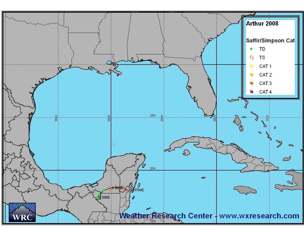
6 NATIONAL SUMMARY 1. Tropical Storm ARTHUR - 31 May 2 June 2008 Northeastern Belize A tropical wave moved into the western Caribbean on May 30 and combined with the remnants of eastern Pacific Tropical Storm Alma, causing an increase in showers and thunderstorms as well as the development of a low, about 75 nautical miles southeast of Belize. The low developed into Tropical Storm Arthur late on the 30 th east of Belize City, Belize. Arthur did not remain over water for a long time and made landfall in northeastern Belize between Belize City and Chetumal Mexico very early on the morning of the 31 st with peak wind of 40 knots. Arthur weakened to a tropical depression the next day as the storm moved further inland. Arthur was responsible for five deaths in Belize due to flooding. 2. Hurricane BERTHA 3-20 July 2008 A strong tropical wave with an associated low moved off the west coast of Africa on July 1 st and conditions were favorable for the low to become a tropical depression very early on the 3 rd, about 220 nautical miles south-southeast of the Cape Verde Islands. Tropical Storm Bertha developed just six hours after the depression formed while passing south of the Cape Verde Islands. As Bertha remained on a west-northwest track over the eastern Atlantic, strengthening continued and Bertha became the first hurricane of the season early on July 7 th. The intensity of Bertha fluctuated over the next few days beginning with rapid intensification of the system to a major hurricane reaching peak sustained winds of 110 knots just 18 hours after becoming a hurricane. On July 8 th, shear increased over the system causing rapid weakening of Bertha to a Category 1 hurricane. As Bertha continued on a northwest to west-northwest track around the western periphery of a ridge of high pressure on the 9 th, the shear decreased which allowed for another period of rapid intensification to a Category 2 hurricane with winds of 90 knots. The system weakened to a Category 1 and remained a weak hurricane through the morning of July 13 th. As Bertha neared Bermuda, it went over cooler waters causing the hurricane to weaken to a tropical storm. On July 14 th, Bertha passed about 40 nautical miles to the east, bringing tropical storm conditions to the island. After passing near Bermuda, Bertha moved to the east and southeast around a low in the north-central Atlantic. On the afternoon of the 18 th, Bertha became a hurricane again for a 24 hour period before becoming extratropical early on July 20 th, southeast of Cape Race Newfoundland. The track of Bertha lasted 17 days making it the longest July storm on record. Much of the east coast of the United States experienced rip currents and dangerous surf conditions due to Bertha. 3. Tropical Storm CRISTOBAL July 2008 An area of low pressure developed along a trough of low pressure near the southwest coast of Florida on July 16 th. The low moved northeast across Florida and into the Atlantic, just off the coast of Georgia on July 17 th. Showers and thunderstorms increased with the system and a tropical depression formed late on July 18 th, about 60
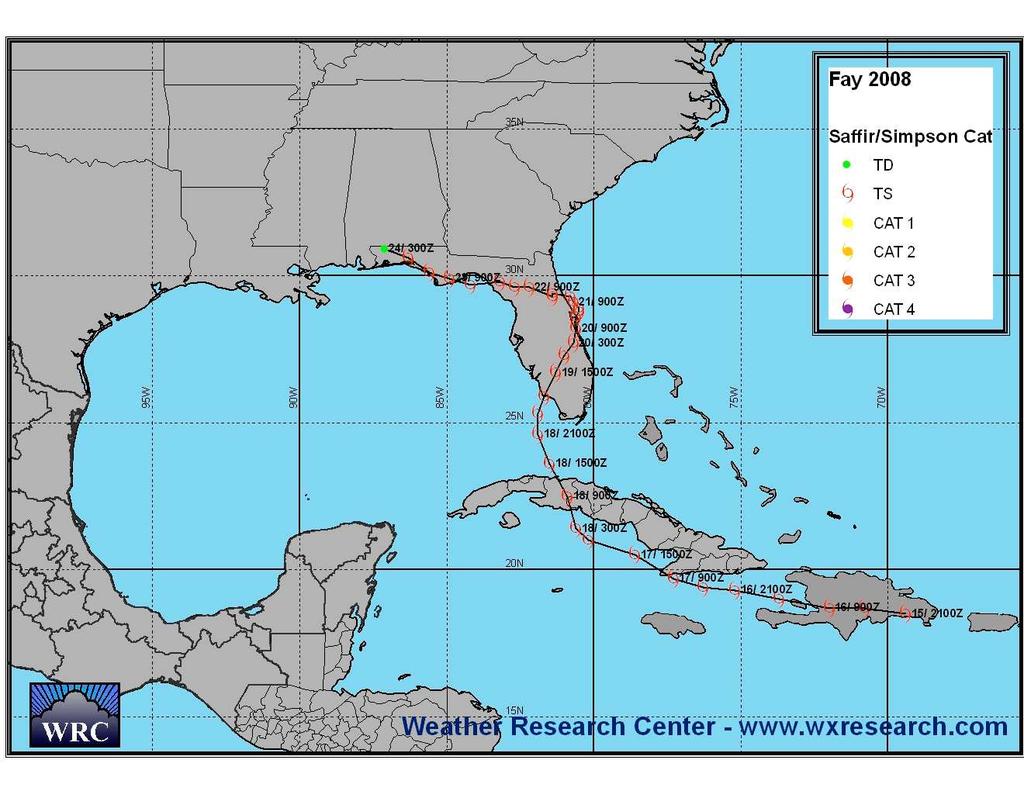
7 nautical miles east of the Georgia/South Carolina border. Tropical Depression Three intensified into Tropical Storm Cristobal 12 hours later while passing near the Outer Banks of North Carolina. Cristobal experienced favorable atmospheric conditions over the next few days and reached peak intensity of 55 knots with a minimum central pressure of 998 mb, on the morning of July 22 nd. After which, Cristobal weakened as the storm encountered cooler waters southeast of Cape Cod, Massachusetts. 4. Hurricane DOLLY July 2008 South Padre, Texas Hurricane Dolly began as a tropical wave that moved off the coast of Africa on July 11 th. A low pressure system developed along the wave on July 13 th, about 1,600 nautical miles east of the Windward Islands. The wave and low moved across the Caribbean and when the system moved into the western Caribbean on July 20 th, Tropical Storm Dolly developed about 300 nautical miles east of Chetumal, Mexico. Dolly moved over the northern tip of the Yucatan Peninsula and into the Gulf of Mexico on the 21 st. Conditions were favorable for intensification in the Gulf of Mexico allowing Dolly to strengthen and reach hurricane intensity on the afternoon of July 22 nd. Dolly became a Category 2 hurricane with peak intensity of 85 knots just prior to making landfall on South Padre, Texas during the late morning of July 23 rd. As Dolly moved inland, the system gradually weakened, becoming a tropical depression as it crossed the Rio Grande River. One death was attributed to Dolly in Florida. 5. Tropical Storm EDOUARD 3-5 August 2008 McFaddin National Wildlife Refuge, Texas A trough of low pressure moved into the northern Gulf of Mexico on August 2 nd. By the morning of August 3 rd, an area of low pressure developed along the trough south of the Florida panhandle. The low became Tropical Depression Four that morning, about 140 nautical miles south of Pensacola, Florida, and continued to intensify into Tropical Storm Edouard that night. The storm remained weak the next day as it tracked west around the southern periphery of high pressure over the south-central United States. Shear over the system decreased on the 5 th allowing Edouard to intensify as it took a west-northwest turn toward the upper Texas Coast. Edouard reached peak intensity of 55 knots prior to making landfall at McFaddin National Wildlife Refuge, between High Island and Sabine Pass, on the morning of the 5 th. The interaction with land caused Edouard to weaken and become a tropical depression late on July 5 th. One death was reported in the Mississippi River caused by Edouard. 6. Tropical Storm FAY August 2008 Western Cuba; Key West, Florida; Cape Romano, Florida; Flagler Beach, Florida; Carrabelle, Florida Tropical Storm Fay formed from a tropical wave on August 15 th as it crossed the eastern coast of Hispaniola. Fay moved off the west coast of Hispaniola on the 16 th and tracked to the west, moving just off the southern coast of eastern Cuba on August 17 th. High pressure over the Atlantic allowed Fay to take a turn toward the northnorthwest which caused the storm to move over central Cuba early on the 18 th. Winds
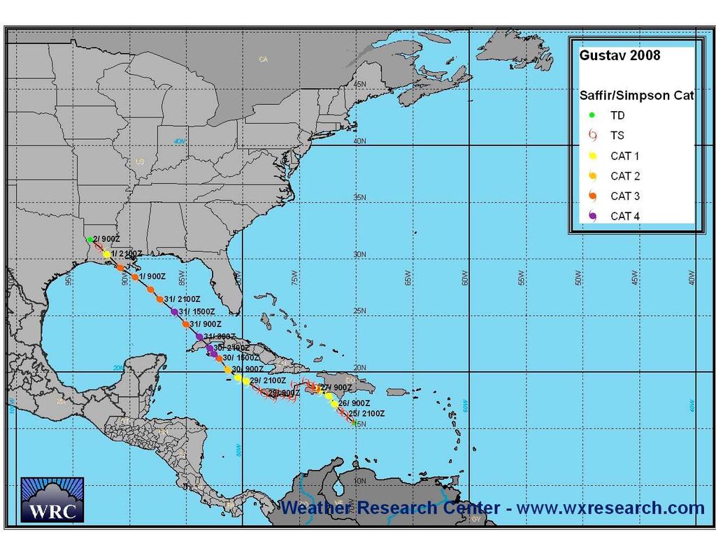
8 increased once Fay moved into the southeastern Gulf of Mexico later that day and the system made its first landfall over Key West late on the 18 th. Tropical Storm Fay made its second landfall in the United States at Cape Romano, Florida early on August 19 th. Strengthening occurred over land and Fay reached peak intensity of 55 knots while over the western shores of Lake Okeechobee. After which, Fay weakened slightly as it moved toward the northeast over southern Florida. Fay moved off the east coast of Florida for a brief period on August 20 th and 21 st then moved back inland near Flagler Beach, Florida. High pressure over the eastern United States caused Fay to be steered to the west-northwest to west over the Florida panhandle. Along this track, the tropical storm moved off the Florida coast once again into Apalachee Bay early on August 23 rd. Fay then made its fourth US landfall over Florida near Carrabelle. This is the only storm on record to make landfall four times in the state of Florida and to prompt tropical storm and hurricane watches and warnings for the state s entire coastline. Fay weakened to a tropical depression after making landfall on the 24 th. Because of Fay s slow movement, heavy rainfall was dumped over portions in Florida, some receiving over two feet of rain. Fay is responsible for numerous deaths in the Dominican Republic, Haiti and Florida. 7. Hurricane GUSTAV 25 August 2 September 2008 Southwestern Haiti; Jamaica; Pinar del Rio, Cuba; Cocodrie, Louisiana Tropical Depression Seven developed early on August 25 th over the southeastern Caribbean Sea, about 110 nautical miles northeast of Bonaire in the Netherlands Antilles, from a tropical wave that moved off the west coast of Africa on August 13 th. TD Seven became Tropical Storm Gustav later on the 25 th as it moved to the northwest and continued to intensify, becoming a hurricane early on August 26 th. Gustav made its first landfall as a Category 1 hurricane over the southwestern peninsula of Haiti on the afternoon of the 26 th. Gustav moved west-southwest back over the waters of the Caribbean on August 27 th then moved over Jamaica on the 28 th as a tropical storm. By the 29 th, Gustav moved into the northwestern Caribbean and strengthened back into a hurricane as it approached the Cayman Islands. The hurricane moved over the Cayman Islands early on August 30 th as a Category 1 then rapidly intensified into a Category 4 hurricane later that day prior to making landfall in the Cuban provinces of the Isle of Youth and Pinar del Rio. Gustav moved toward the northwest across the southeastern Gulf of Mexico on August 31 st and September 1 st heading toward the central Gulf Coast. Hurricane Gustav made its final landfall near Cocodrie, Louisiana on the morning of September 1 st as a Category 2. Over 112 deaths were attributed to Gustav, 77 of which were in Haiti. 8. Hurricane HANNA 28 August 7 September 2008 South Carolina/North Carolina border On August 26 th, an area of low pressure formed along a tropical wave, about 550 nautical miles east-northeast of the northern Leeward Islands. The low became Tropical Depression Eight on the morning of August 28 th and intensified into Tropical Storm Hanna by the afternoon. Over the next several days, Tropical Storm Hanna
9 moved a west-northwest track, remaining north of the Leeward Islands and Puerto Rico. By the 1 st of September, Hanna began moving toward the south and intensified into a hurricane, reaching peak intensity of 70 knots early on September 2 nd while passing over portions of the Caicos Islands. Shear increased over the system causing it to weaken later that day into the next day, while making a counter-clockwise loop between the Turks and Caicos Islands and the northern coast of Hispaniola. Hanna then began moving on a northwest track toward the southeast coast of the United States. The system took a turn to the north on September 5 th and made landfall near the border of North Carolina and South Carolina during the early morning of the 6 th. After making landfall, Hanna remained a tropical storm and began moving to the northeast along the mid-atlantic coast. Hanna transitioned to an extratropical cyclone early on September 7 th when it moved off the coast of Massachusetts. Hanna caused heavy rainfall in Haiti resulting in over 500 deaths. 9. Hurricane IKE 1-14 September 2008 Province of Holguin, Cuba; Pinar del Rio, Cuba; Galveston, Texas A strong tropical wave moved off the coast of Africa on August 28 th and developed into Tropical Depression Nine on the 1 st of September, about 1,470 nautical miles east of the Leeward Islands. TD Nine became Tropical Storm Ike just six hours later and gradual intensification followed over the next two days as it moved toward the westnorthwest in the central Atlantic. Ike became a hurricane on the afternoon of September 3 rd then rapidly intensified, becoming a Category 3 that night and a Category 4 by the next morning. Peak intensity of 125 knots was reached on the morning of the 4 th, about 550 nautical miles northeast of the Leeward Islands. An increase of wind shear along the track of the system caused Ike to weaken slightly on September 5 th and 6 th, but then Ike re-intensified into a Category 4 hurricane prior to moving across the Turks and Caicos Islands and Great Inagua Island in the southeastern Bahamas early on the 7 th. Ike made landfall in the Province of Holguin in Cuba early on September 8 th as a Category 3 on the Saffir-Simpson Scale. Weakening occurred as Ike moved west across the southern coast of Cuba. Ike made a second landfall over the southeastern part of the Province of Pinar Del Rio on September 9 th. The hurricane emerged in the southeastern Gulf of Mexico later on the 9 th and tracked northwest across the Gulf of Mexico toward the Texas Coast, intensifying into a Category 2 hurricane. Ike made landfall along the north end of Galveston Island in the early morning hours of September 13 th with maximum sustained winds of 95 knots. The interaction with land caused Ike to weaken, although the extratropical remnants of Ike produced winds gusts to hurricane force causing major damage along its path through eastern Texas, Arkansas and up through the Ohio Valley. Flooding caused 74 deaths in Haiti and two in the Dominican Republic. Seven deaths were reported in Cuba from Ike. Storm surge from Hurricane Ike devastated parts of the Upper Texas Coast including Galveston Island and the Bolivar Peninsula. Nineteen deaths were caused along its path in the United States. Ike grew in size while tracking across the Gulf of Mexico, which caused the tides along the Texas coast to rise on Friday, while the center of Ike was still over 200 miles from landfall.
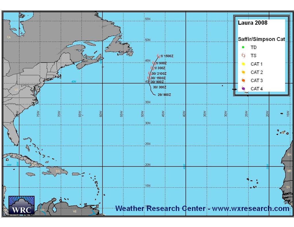
10 10. Tropical Storm JOSEPHINE 2-6 September 2008 Tropical Depression Ten developed late on September 1 st about 275 nautical miles south-southeast of Sal in the Cape Verde Islands, from a strong tropical wave that moved off the west coast of Africa 24 hours before. Thunderstorm activity increased quickly and TD Ten intensified into Josephine six hours after development. Josephine was steered on a west to west-northwest track around the southern edge of a high pressure system to the north. Josephine reached peak intensity of 55 knots very early on September 3 rd. Later that day, shear increased over the system causing the storm to begin to weaken. Josephine weakened to a tropical depression early on September 6 th. The remnant low of Josephine was monitored over the next few days for any signs of re-intensification but conditions remained unfavorable. 11. Hurricane KYLE September 2008 Southwestern Nova Scotia A tropical wave moved off the coast of Africa on September 12 th and moved west to west-southwest across the eastern and central Atlantic over the next few days. The wave interacted with an upper level low over the eastern Caribbean Sea as it approached the Lesser Antilles causing an increase in thunderstorms. An area of low pressure developed along the wave on the 19 th and moved northwest, causing it to separate from the wave. The low moved over Hispaniola and continued into the Atlantic where it was able to intensify. Tropical Depression Eleven developed late on September 24 th, about 100 nautical miles north of the Dominican Republic, which then intensified into Tropical Storm Kyle six hours later. Kyle moved on a northerly track through the western Atlantic and became a hurricane on the morning of the 27 th about 300 nautical miles west of Bermuda. Peak intensity of 75 knots was reached on the morning of September 28 th. Kyle made landfall as a Category 1 hurricane on the southwestern tip of Nova Scotia just north of Yarmouth on the evening of September 28 th. 12. Tropical Storm LAURA 29 September 1 October 2008 A non-tropical low pressure system over the north-central Atlantic was named Subtropical Storm Laura early on September 29 th, about 1,000 nautical miles west of the westernmost Azores Islands. Laura moved to the north and acquired tropical characteristics on the 30 th but quickly lost the tropical characteristics on October 1 st, about 300 nautical miles east of Cape Race, Newfoundland.
11 13. Tropical Storm MARCO 6-8 October 2008 Between Tuxpan and Veracruz, Mexico A broad area of low pressure persisted over the northwestern Caribbean Sea and Yucatan Peninsula during the end of September. A tropical wave moved into the southwestern Caribbean Sea on October 4 th causing the low to become better defined. The low then moved across the Yucatan Peninsula and became Tropical Depression Thirteen late on October 5 th while centered over the Terminos Lagoon in the state of Campeche, Mexico. When TD 13 moved into the Bay of Campeche, strengthening occurred and Tropical Storm Marco developed on the morning of the 6 th, about 60 nautical miles northeast of Coatzacoalcos, Mexico. Conditions remained favorable for further development over the next 12 hours allowing Marco to reach peak intensity of 55 knots later that day. Marco made landfall east of Misantla between Tuxpan and Veracruz, Mexico on the morning of October 7 th. Marco was very small in size with tropical storm force winds only extending out 12 miles, making it the smallest tropical storm on record. 14. Tropical Storm NANA October 2008 Tropical Depression Fourteen formed very early on October 12 th, about 690 nautical miles west of the Cape Verde Islands, from a tropical wave that moved off the coast of Africa on October 6 th. TD 14 intensified into Tropical Storm Nana six hours later reaching peak intensity of 35 knots, but strong upper level winds prevented any further strengthening over the next day. Nana weakened back into a tropical depression on the morning of the 13 th, about 870 nautical miles west of the Cape Verde Islands, and became a remnant low on October 14 th. 15. Hurricane OMAR October 2008 A tropical wave moved off the west coast of Africa on September 30 th and reached the eastern Caribbean Sea on October 10 th. An area of low pressure developed and intensified into a tropical depression on the 13 th, about 220 nautical miles northnorthwest of Curacao in the Netherlands Antilles. Weak steering currents kept the depression fairly stationary over the next 24 hours. On the morning of the 14 th, the depression became Tropical Storm Omar. Omar rapidly intensified as it moved northeast in the eastern Caribbean Sea, becoming a hurricane late on October 15 th, and reaching peak intensity of 110 knots on the morning of the 16 th as it passed through the Virgin and Northern Leeward Islands. Shear increased over the track of Omar later that day causing the hurricane to weaken. A small window of favorable conditions allowed Omar to re-intensify on October 17 th as the system moved rapidly toward the northeast across the central Atlantic. Omar weakened again and became a remnant low on the 18 th, about 865 nautical miles south-southeast of Cape Race, Newfoundland.
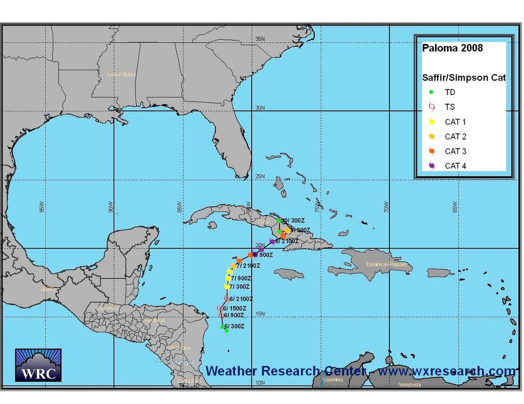
12 16. Hurricane PALOMA 5-10 November 2008 Santa Cruz del Sur, Cuba A tropical wave moved into the southwestern Caribbean Sea on November 4 th and combined with a broad area of low pressure that had persisted over the region for several days to increase showers and thunderstorms. The area of disturbed weather intensified into a tropical depression on the 5 th, about 115 nautical miles east of Cabo Gracias a Dios along the Nicaragua/Honduras border. The depression became Tropical Storm Paloma early on November 6 th then began to rapidly intensify, becoming a hurricane early on the 7 th, about 280 nautical miles west-southwest of Montego Bay, Jamaica. Paloma moved north then northeast in the western Caribbean and continued to rapidly intensify. Paloma reached peak intensity of 125 knots on the afternoon of November 8 th near the southern coast of Cuba, making it the second strongest November hurricane on record. An increase in wind shear caused Paloma to weaken slightly to a Category 3 before making landfall near Santa Cruz del Sur, Cuba late on November 8 th. Rapid weakening of Paloma began after landfall due to interaction with land and continued high wind shear causing the system to become a tropical storm on the 9 th and tropical depression by November 10 th.
13
14
15
16
17
18
19
20
21
22
23
24
25
26
27
28
29
30
31
32
33
34
35
36
37
38
39
40
41
42
43
44
45
46
2006 ATLANTIC HURRICANE SUMMARY. Weather Research Center Houston, Texas
 2006 ATLANTIC HURRICANE SUMMARY Weather Research Center Houston, Texas Weather Research Center 5104 Caroline Houston, Texas 77004 Phone: 713-529-3076 Fax: 713-528-3538 E-mail: wrc@wxresearch.org 2006 Atlantic
ovember 2008 Antigua and Barbuda Meteorological Service
 ovember 2008 Antigua and Barbuda Meteorological Service The Atlantic Hurricane Season Summary 2008 Special Focus on Antigua and Barbuda The Season in Brief Sixteen (16) named storms formed in the Atlantic
Tropical Update. 5 AM EDT Wednesday, September 6, 2017 Hurricane Irma, Tropical Storm Jose, and Tropical Storm Katia
 Tropical Update 5 AM EDT Wednesday, September 6, 2017 Hurricane Irma, Tropical Storm Jose, and Tropical Storm Katia This update is intended for government and emergency response officials, and is provided
Tropical Update. 5 AM EDT Thursday, September 7, 2017 Hurricane Irma, Hurricane Jose, and Hurricane Katia
 Tropical Update 5 AM EDT Thursday, September 7, 2017 Hurricane Irma, Hurricane Jose, and Hurricane Katia This update is intended for government and emergency response officials, and is provided for informational
Tropical Update. 5 PM EDT Thursday, September 7, 2017 Hurricane Irma, Hurricane Jose, and Hurricane Katia
 Tropical Update 5 PM EDT Thursday, September 7, 2017 Hurricane Irma, Hurricane Jose, and Hurricane Katia This update is intended for government and emergency response officials, and is provided for informational
Hurricane Matthew Page 1 Location Forecast Analysis Summary Report - Advanced Wind Estimation On
 Page 1 Current NHC Forecast Predictions Maximum Sustained Winds / Storm Category: 138 MPH / Category 4 Forward motion: 9 mph towards the North Hurricane Force winds extend from the center: 46 miles Tropical
Tropical Update. 5 PM EDT Tuesday, September 5, 2017 Hurricane Irma, Tropical Storm Jose, and Tropical Depression Thirteen
 Tropical Update 5 PM EDT Tuesday, September 5, 2017 Hurricane Irma, Tropical Storm Jose, and Tropical Depression Thirteen This update is intended for government and emergency response officials, and is
Tropical Update. 5 AM EDT Monday, October 8, 2018 Tropical Storm Michael, Tropical Storm Leslie, Invest 92L (10%) & African Tropical Wave (50%)
 & African Tropical Wave (50%)") Tropical Update 5 AM EDT Monday, October 8, 2018 Tropical Storm Michael, Tropical Storm Leslie, Invest 92L (10%) & African Tropical Wave (50%) This update is intended for government and emergency response
Tropical Update 5 AM EDT Monday, October 8, 2018 Tropical Storm Michael, Tropical Storm Leslie, Invest 92L (10%) & African Tropical Wave (50%) This update is intended for government and emergency response
SUMMARY OF 2008 ATLANTIC TROPICAL CYCLONE ACTIVITY AND VERIFICATION OF AUTHOR S SEASONAL AND MONTHLY FORECASTS
 SUMMARY OF 2008 ATLANTIC TROPICAL CYCLONE ACTIVITY AND VERIFICATION OF AUTHOR S SEASONAL AND MONTHLY FORECASTS The 2008 hurricane season had activity at well above-average levels. Our project s new forecast
2015 Hurricane Season Summary for Eastern Canada Impacts and Operational Notes
 2015 Hurricane Season Summary for Eastern Canada Impacts and Operational Notes John Parker Canadian Hurricane Centre, Meteorological Service of Canada April, 2016 Storms affecting Canadian territory in
Tropical Update. 5 PM EDT Sunday, October 7, 2018 Tropical Storm Michael, Tropical Storm Leslie, & Invest 92L (30%)
") Tropical Update 5 PM EDT Sunday, October 7, 2018 Tropical Storm Michael, Tropical Storm Leslie, & Invest 92L (30%) This update is intended for government and emergency response officials, and is provided
Tropical Update 5 PM EDT Sunday, October 7, 2018 Tropical Storm Michael, Tropical Storm Leslie, & Invest 92L (30%) This update is intended for government and emergency response officials, and is provided
Tropical Update. 5 PM EDT Sunday, September 10, 2017 Hurricane Irma, Hurricane Jose, Tropical Wave (60%)
") Tropical Update 5 PM EDT Sunday, September 10, 2017 Hurricane Irma, Hurricane Jose, Tropical Wave (60%) This update is intended for government and emergency response officials, and is provided for informational
Tropical Update 5 PM EDT Sunday, September 10, 2017 Hurricane Irma, Hurricane Jose, Tropical Wave (60%) This update is intended for government and emergency response officials, and is provided for informational
WEATHER SYSTEMS IMPACTING THE CAYMAN ISLANDS Prepared by the staff of the Cayman Islands National Weather Service
 WEATHER SYSTEMS IMPACTING THE CAYMAN ISLANDS 2008 Prepared by the staff of the Cayman Islands National Weather Service TROPICAL STORM DOLLY Formed 194 miles west of Grand Cayman July 19 th. The tropical
& ~ Hurricane Season Review ~
 & ~ Hurricane Season Review ~ St. Maarten Hurricane Gonzalo: Monday October 13 th 2014 @ 5:15pm Meteorological Department St. Maarten Airport Rd. # 69, Simpson Bay (721) 545-2024 or (721) 545-4226 www.meteosxm.com
Tropical Update. 5 PM EDT Thursday, August 27, 2015 Tropical Storm Erika
 Tropical Update 5 PM EDT Thursday, August 27, 2015 Tropical Storm Erika This update is intended for government and emergency response officials, and is provided for informational and situational awareness
Atlantic Basin Satellite Image
 Tropical Update 11 AM EDT Friday, September 7, 2018 Tropical Depression Gordon, Tropical Storm Florence, Potential Tropical Cyclone #8 (90%), Invest 92L (90%) This update is intended for government and
GC Briefing. Weather Sentinel Tropical Storm Michael. Status at 8 AM EDT (12 UTC) Today (NHC) Discussion. October 11, 2018
 Today (NHC) Discussion. October 11, 2018") GC Briefing Weather Sentinel Tropical Storm Michael October 11, 2018 After making landfall as a high-end category-4 hurricane on the Florida Panhandle, Michael weakened to tropical storm status early this
GC Briefing Weather Sentinel Tropical Storm Michael October 11, 2018 After making landfall as a high-end category-4 hurricane on the Florida Panhandle, Michael weakened to tropical storm status early this
Current Details from the National Hurricane Center (NHC)
") Current Watches and Warnings A Hurricane Warning is in effect for Dominican Republic from Cabo Engano to the northern border with Haiti; Haiti from the northern border with the Dominican Republic to Le
Current Watches and Warnings A Hurricane Warning is in effect for Dominican Republic from Cabo Engano to the northern border with Haiti; Haiti from the northern border with the Dominican Republic to Le
Ch. 11: Hurricanes. Be able to. Define what hurricane is. Identify the life and death of a hurricane. Identify the ways we track hurricanes.
 Ch. 11: Hurricanes Be able to Define what hurricane is. Identify the life and death of a hurricane. Identify the ways we track hurricanes. What are Hurricanes? Smaller than mid-latitude cyclones. Don t
Residents of the Southeastern United
 Summary of 2004 Atlantic Basin Tropical Cyclone Activity and Verification of Seasonal Forecasts By Philip Klotzbach Department of Atmospheric Science Colorado State University Fort Collins, CO 80523 philk@atmos.colostate.edu
At the Midpoint of the 2008
 At the Midpoint of the 2008 Atlantic Hurricane Season Editor s note: It has been an anxious couple of weeks for those with financial interests in either on- or offshore assets in the Gulf of Mexico and
What s s New for 2009
 What s s New for 2009 Graphical Tropical Weather Outlook becomes operational Special Tropical Disturbance Statement replaced with Special Tropical Weather Outlook Tropical Cyclone Wind Field Graphic becomes
Storm Summary for Hurricane Joaquin
 Storm Summary for Hurricane Joaquin Wednesday, September 30, 2015 at 5 PM EDT (Output from Hurrevac, based on National Hurricane Center Forecast Advisory #12) Joaquin is currently a Category 1 hurricane
Tropical Update 11 AM EDT Thursday, September 6, 2018 Tropical Depression Gordon, Hurricane Florence, Invest 92L (90%) & African Tropical Wave (50%)
 & African Tropical Wave (50%)") Tropical Update 11 AM EDT Thursday, September 6, 2018 Tropical Depression Gordon, Hurricane Florence, Invest 92L (90%) & African Tropical Wave (50%) This update is intended for government and emergency
Tropical Update 11 AM EDT Thursday, September 6, 2018 Tropical Depression Gordon, Hurricane Florence, Invest 92L (90%) & African Tropical Wave (50%) This update is intended for government and emergency
Tropical Update. 11 AM EDT Tuesday, October 9, 2018 Hurricane Michael, Tropical Storm Leslie, Tropical Storm Nadine
 Tropical Update 11 AM EDT Tuesday, October 9, 2018 Hurricane Michael, Tropical Storm Leslie, Tropical Storm Nadine This update is intended for government and emergency response officials, and is provided
HURRICANE JEANNE CHARACTERISTICS and STORM TIDE EVALUATION
 HURRICANE JEANNE CHARACTERISTICS and STORM TIDE EVALUATION ((DRAFT)) By Robert Wang and Michael Manausa Sponsored by Florida Department of Environmental Protection, Bureau of Beaches and Coastal Systems
Hurricane Wilma Post Storm Data Acquisition Estimated Peak Wind Analysis and Storm Tide Data. December 27, 2005
 Hurricane Wilma Post Storm Data Acquisition Estimated Peak Wind Analysis and Storm Tide Data December 27, 2005 Hurricane Wilma was the sixth major hurricane of the record-breaking 2005 Atlantic hurricane
photo courtesy of
 BRITISH VIRGIN ISLANDS REPORT TROPICAL STORM JEANNE photo courtesy of www.bviplatinum.com PREPARED BY THE DEPARTMENT OF DISASTER MANAGEMENT 1 EVENT 13 th -16 th September, 2004 TROPICAL STORM JEANNE Sequence
Tropical Update. 12 PM EDT Friday, October 7, 2016 Hurricane Matthew & Tropical Storm Nicole
 Tropical Update 12 PM EDT Friday, October 7, 2016 Hurricane Matthew & Tropical Storm Nicole This update is intended for government and emergency response officials, and is provided for informational and
Monthly Long Range Weather Commentary Issued: SEPTEMBER 19, 2016 Steven A. Root, CCM, Chief Analytics Officer, Sr. VP,
 Monthly Long Range Weather Commentary Issued: SEPTEMBER 19, 2016 Steven A. Root, CCM, Chief Analytics Officer, Sr. VP, sroot@weatherbank.com SEPTEMBER 2016 Climate Highlights The Month in Review The contiguous
HURRICANE FRANCES CHARACTERISTICS and STORM TIDE EVALUATION
 HURRICANE FRANCES CHARACTERISTICS and STORM TIDE EVALUATION ((DRAFT)) By Robert Wang and Michael Manausa Sponsored by Florida Department of Environmental Protection, Bureau of Beaches and Coastal Systems
GC Briefing. Weather Sentinel Hurricane Florence. Status at 5 PM EDT (21 UTC) Today (NHC) Discussion. September 13, 2018
 Today (NHC) Discussion. September 13, 2018") GC Briefing September 13, 2018 Weather Sentinel Hurricane Florence Tropical storm conditions have been reported for areas of North Carolina and will continue to spread inland to the west and south. Hurricane
GC Briefing September 13, 2018 Weather Sentinel Hurricane Florence Tropical storm conditions have been reported for areas of North Carolina and will continue to spread inland to the west and south. Hurricane
An upper to mid level circulation (Low) in the NW Caribbean is
 in the NW Caribbean is") WEEKLY WEATHER OUTLOOK BELIZE, CENTRAL AMERICA PERIOD: Monday-Monday, Oct. 1 October 8, 2012 DATE ISSUED: Monday, Oct 1, 2012 6:00 am RFrutos EcoSolutions & Services SYNOPSIS: An upper to mid level circulation
WEEKLY WEATHER OUTLOOK BELIZE, CENTRAL AMERICA PERIOD: Monday-Monday, Oct. 1 October 8, 2012 DATE ISSUED: Monday, Oct 1, 2012 6:00 am RFrutos EcoSolutions & Services SYNOPSIS: An upper to mid level circulation
Weather Research Center
 Weather Research Center 3227 Audley Houston, Texas 77098 Phone: 713-529-3076 Fax: 713-528-3538 E-mail: wrc@wxresearch.org Press Release For Immediate Release November 29, 2005 For Information Contact:
(April 7, 2010, Wednesday) Tropical Storms & Hurricanes Part 2
 Tropical Storms & Hurricanes Part 2") Lecture #17 (April 7, 2010, Wednesday) Tropical Storms & Hurricanes Part 2 Hurricane Katrina August 2005 All tropical cyclone tracks (1945-2006). Hurricane Formation While moving westward, tropical disturbances
Lecture #17 (April 7, 2010, Wednesday) Tropical Storms & Hurricanes Part 2 Hurricane Katrina August 2005 All tropical cyclone tracks (1945-2006). Hurricane Formation While moving westward, tropical disturbances
Major Hurricane Earl
 Major Hurricane Earl Advisory 33 North Carolina Threat Assessment Prepared at: 11 AM Thursday September 2, 2010 Hurricane and Tropical Storm Warnings in effect for the North Carolina Coast and Sounds NWS
Tropical Storm Harvey: SE Texas Impacts
 Tropical Storm Harvey: SE Texas Impacts 10 AM CDT UPDATE Thursday, August 24, 2017 Prepared by: Dan Reilly, Brian Kyle PLEASE MUTE YOUR LINES AND DON T PUT ON HOLD! Situation Overview Tropical Storm Harvey
Major Hurricane Earl
 Major Hurricane Earl Advisory 32 North Carolina Threat Assessment Prepared at: 8 AM Thursday September 2, 2010 Hurricane and Tropical Storm Warnings in effect for the North Carolina Coast and Sounds. NWS
HURRICANE IRENE. CONFERENCE CALL BRIEFING SLIDES Saturday August 27, :30 AM
 HURRICANE IRENE CONFERENCE CALL BRIEFING SLIDES Saturday August 27, 2011 8:30 AM NHC TRACK AND CONE HURRICANE IRENE WATCHES/WARNINGS Hurricane Warning along south coast including all of Cape Cod and Islands
Tropical Update. 11 AM EDT Wednesday, October 10, 2018 Hurricane Michael, Hurricane Leslie & Tropical Storm Nadine, Caribbean Low (40%)
") Tropical Update 11 AM EDT Wednesday, October 10, 2018 Hurricane Michael, Hurricane Leslie & Tropical Storm Nadine, Caribbean Low (40%) This update is intended for government and emergency response officials,
Tropical Update 11 AM EDT Wednesday, October 10, 2018 Hurricane Michael, Hurricane Leslie & Tropical Storm Nadine, Caribbean Low (40%) This update is intended for government and emergency response officials,
Tropical Update. 1 PM EDT Monday, May 21, 2018 Caribbean Disturbance (20%)
") Tropical Update 1 PM EDT Monday, May 21, 2018 Caribbean Disturbance (20%) This update is intended for government and emergency response officials, and is provided for informational and situational awareness
Tropical Update 1 PM EDT Monday, May 21, 2018 Caribbean Disturbance (20%) This update is intended for government and emergency response officials, and is provided for informational and situational awareness
Hurricanes. Hurricanes are large, tropical storm systems that form and develop over the warm waters near the equator.
 Hurricanes Hurricanes are large, tropical storm systems that form and develop over the warm waters near the equator. They are responsible for weather that can devastate entire communities: Heavy rain --
Chapter 24 Tropical Cyclones
 Chapter 24 Tropical Cyclones Tropical Weather Systems Tropical disturbance a cluster of thunderstorms about 250 to 600 km in diameter, originating in the tropics or sub-tropics Tropical depression a cluster
Chapter 16, Part Hurricane Paths. 2. Hurricane Paths. Hurricane Paths and Damage
 Chapter 16, Part 2 Hurricane Paths and Damage 1. Hurricane Paths Start over tropical water except South Atlantic and eastern South Atlantic, where water is too cold. Initially steered by easterly winds
The 2014 Atlantic Hurricane Season. What is New and What to Expect. Mark Chambers President & CEO ImpactWeather, Inc.
 The 2014 Atlantic Hurricane Season What is New and What to Expect Mark Chambers President & CEO ImpactWeather, Inc. Hurricane Climatology for the Gulf of Mexico A Look back at 2013 The outlook for this
Hurricane Irma Page 1 HURRTRAK RM/Pro 2017 Summary Report for Tampa, FL 09/09/ EDT, Adv. # 43
 Hurricane Irma Page 1 Description of impact to Tampa, FL, Tampa, FL, is expected to receive a major impact from Hurricane Irma. The forecast maximum wind for this location has decreased since the last
Tropical Update 6 AM EDT Friday, October 7, 2016 Hurricane Matthew & Hurricane Nicole
 Tropical Update 6 AM EDT Friday, October 7, 2016 Hurricane Matthew & Hurricane Nicole This update is intended for government and emergency response officials, and is provided for informational and situational
GOES-13 IMAGE OF HURRICANE SANDY AT 1745 UTC 28 OCTOBER ABSTRACT
 NATIONAL HURRICANE CENTER ANNUAL SUMMARY 2012 ATLANTIC HURRICANE SEASON Stacy Stewart 23 January 2014 GOES-13 IMAGE OF HURRICANE SANDY AT 1745 UTC 28 OCTOBER 2012. ABSTRACT The 2012 Atlantic hurricane
Hurricane Irma Page 1 HURRTRAK RM/Pro 2017 Summary Report for Tampa, FL 09/10/ EDT, Adv. # 46
 Hurricane Irma Page 1 Description of impact to Tampa, FL, Tampa, FL, is expected to receive a major impact from Hurricane Irma. The forecast maximum wind for this location has increased since the last
STORM HISTORY FOR COLLIER COUNTY
 STORM HISTORY FOR COLLIER COUNTY In 1960, when hurricane 'Donna' struck, there were approximately 15,500 people living full time in Collier County. Today there are more than 330,000 residents, most of
Severe Weather: Tornadoes and Hurricanes
 Severe Weather: Tornadoes and Hurricanes Tornadoes Grab Toto!! TORNADOES Are a low pressure storm that usually forms over land in an average year, 800 tornadoes are reported in the U.S. a tornado is defined
Tropical Update. 5 AM EDT Tuesday, September 12, 2017 Post-Tropical Cyclone Irma, Hurricane Jose, & Tropical Wave (10%)
") Tropical Update 5 AM EDT Tuesday, September 12, 2017 Post-Tropical Cyclone Irma, Hurricane Jose, & Tropical Wave (10%) This update is intended for government and emergency response officials, and is provided
Tropical Update 5 AM EDT Tuesday, September 12, 2017 Post-Tropical Cyclone Irma, Hurricane Jose, & Tropical Wave (10%) This update is intended for government and emergency response officials, and is provided
HURRICANE HARVEY COE Navigation BRIEFING
 HURRICANE HARVEY COE Navigation BRIEFING 10:00 AM CDT Friday, August 25, 2017 NWSNewOrleans www.weather.gov/neworleans Situation Overview New Information Harvey continues to strengthen Max sustained winds
Coastal Storm Potential
 Coastal Storm Potential Event Date/Time: 11/12/2009-11/14/2009 Today through Saturday National Weather Service Newport/Morehead City, NC Date: 11/12/2009 1000 am Coastal Storm Remnants of Ida, coupled
& ~ Hurricane Season Review ~
 & ~ Hurricane Season Review ~ St. Maarten experienced drought conditions in 2016 with no severe weather events. All Photos compliments Paul G. Ellinger Meteorological Department St. Maarten Airport Rd.
Navigating the Hurricane Highway Understanding Hurricanes With Google Earth
 Navigating the Hurricane Highway Understanding Hurricanes With Google Earth 2008 Amato Evan, Kelda Hutson, Steve Kluge, Lindsey Kropuenke, Margaret Mooney, and Joe Turk Images and data courtesy hurricanetracking.com,
METEOROLOGICAL SERVICE NETHERLANDS ANTILLES & ARUBA CLIMATOLOGICAL SUMMARY 2001
 METEOROLOGICAL SERVICE NETHERLANDS ANTILLES & ARUBA CLIMATOLOGICAL SUMMARY 2001 PUBLISHED BY THE METEOROLOGICAL SERVICE OF THE NETHERLANDS ANTILLES AND ARUBA. FEBRUARY 2002. 1 Table of Contents Introduction...
Current Details from the National Hurricane Center (NHC)
") Current Watches and Warnings A Hurricane Warning is in effect from Grand Isle Louisiana to the Alabama/Florida border A Warning is in effect from Punta Herrero to Rio Lagartos Mexico; Pinar del Rio; metropolitan
Current Watches and Warnings A Hurricane Warning is in effect from Grand Isle Louisiana to the Alabama/Florida border A Warning is in effect from Punta Herrero to Rio Lagartos Mexico; Pinar del Rio; metropolitan
Preliminary Assessment of 2017 Atlantic Hurricane Season. Phil Klotzbach. Department of Atmospheric Science. Phil Klotzbach
 Atlantic Basin Basin Tropical Seasonal Cyclone Hurricane Climatology Prediction and Preliminary Assessment of 2017 Atlantic Hurricane Season Phil Klotzbach Department of Atmospheric Science Colorado Phil
Hurricane Harvey: SE Texas Impacts. 10 PM CDT UPDATE Friday, August 25, 2017 Prepared by: Lance Wood
 Hurricane Harvey: SE Texas Impacts 10 PM CDT UPDATE Friday, August 25, 2017 Prepared by: Lance Wood Latest Observations Hurricane Harvey making landfall this evening near Rockport as a category 4 hurricane.
Current Details from the National Hurricane Center (NHC)
") Current Watches/Warnings A Hurricane Warning is in effect from Surf City, North Carolina to the North Carolina/Virginia border; Pamlico Sound; Eastern Albemarle Sound A Hurricane Watch is in effect from
Current Watches/Warnings A Hurricane Warning is in effect from Surf City, North Carolina to the North Carolina/Virginia border; Pamlico Sound; Eastern Albemarle Sound A Hurricane Watch is in effect from
ARUBA CLIMATOLOGICAL SUMMARY 2017 PRECIPITATION
 ARUBA CLIMATOLOGICAL SUMMARY 2017 PRECIPITATION The total amount of rainfall recorded at Reina Beatrix International Airport for the year 2017 was 391.0 mm. This is 17.1 % below normal ( Figure 1 ). During
Major Hurricane Matthew Briefing Situation Overview
 Major Hurricane Matthew Briefing Situation Overview THIS IS NOW A WORST CASE STORM SURGE SCENARIO Catastrophic Damage is Anticipated for Coastal Areas. Major Hurricane Matthew is still expected to move
Storm Summary for Hurricane Jose
 Storm Summary for Hurricane Jose Tuesday, September 19, 2017 at 11 AM EDT (Output from Hurrevac, based on National Hurricane Center Forecast Advisory #57) Jose is currently a Category 1 hurricane on the
Current Details from the National Hurricane Center (NHC)
") Current Watches and Warnings A Hurricane Warning is in effect for the Dominican Republic from Cabo Engano to Puerto Plata; Turks and Caicos Islands and the Southeastern Bahamas A Warning is in effect for
Current Watches and Warnings A Hurricane Warning is in effect for the Dominican Republic from Cabo Engano to Puerto Plata; Turks and Caicos Islands and the Southeastern Bahamas A Warning is in effect for
Hurricane Harvey: SE Texas Impacts. 10 AM CDT UPDATE Saturday, August 26, 2017 Prepared by: Dan Reilly, Brian Kyle
 Hurricane Harvey: SE Texas Impacts 10 AM CDT UPDATE Saturday, August 26, 2017 Prepared by: Dan Reilly, Brian Kyle Latest Observations and Radar Hurricane Harvey centered near Victoria and weakening Wind
Hurricane Tracking Lab
 Hurricane Tracking Lab Background: Hurricanes are one of nature s most powerful disasters. To equal the power of a hurricane, one would have to set off about a thousand nuclear devices per second for as
TROPICAL STORM HARVEY BRIEFING
 TROPICAL STORM HARVEY BRIEFING 10:00 AM CDT Sunday, August 27, 2017 Prepared by: NWS LIX NWSNewOrleans www.weather.gov/neworleans Situation Overview New Information Tropical Storm Winds 40mph Immediate
Current Details from the National Hurricane Center (NHC)
") Current Watches and Warnings A Hurricane Warning is in effect for Anguilla; Saba, St. Eustatius, and Sint Maarten; Saint Martin and Saint Barthelemy; British Virgin Islands; U.S. Virgin Islands; Puerto
Current Watches and Warnings A Hurricane Warning is in effect for Anguilla; Saba, St. Eustatius, and Sint Maarten; Saint Martin and Saint Barthelemy; British Virgin Islands; U.S. Virgin Islands; Puerto
Tropical Storm Ana. Created 6:00 AM Sun May 10, 2015 John Cole Warning Coordination Meteorologist
 Tropical Storm Ana Threat Assessment for Eastern North Carolina Created 6:00 AM Sun May 10, 2015 John Cole Warning Coordination Meteorologist John.cole@noaa.gov National Weather Service Newport/Morehead
Region IX Daily Situational Awareness Report (DSAR) As of 0900 PDT, Monday, October 05, 2015
 As of 0900 PDT, Monday, October 05, 2015") Region IX Daily Situational Awareness Report (DSAR) As of 0900 PDT, Monday, October 05, 2015 For Official Use Only (FOUO) by the employees of the Federal Emergency Management Agency and other agencies
Region IX Daily Situational Awareness Report (DSAR) As of 0900 PDT, Monday, October 05, 2015 For Official Use Only (FOUO) by the employees of the Federal Emergency Management Agency and other agencies
Introduction to Tropical Cyclones
 Introduction to Tropical Cyclones Daniel Brown & Robbie Berg National Hurricane Center Florida Governor s Hurricane Conference 24 May 2010 Image courtesy of NASA/Goddard Space Flight Center Scientific
9. Besides tourism, what other methods do people in the Caribbean islands use to generate
 9. Besides tourism, what other methods do people in the Caribbean islands use to generate wealth? 10. How do differences in musical styles tell a story of Caribbean culture? G E O G R A P H Y E X E R C
WEDNESDAY 30 TH AUGUST, :57 p.m. Tropical Storm Irma forms in the Atlantic. Don t let your guard down, always #Be Ready.
 Chapter 1 - The Set Up In the days leading up to Irma a series of composed and sobering text messages, presented in truncated form below, from Department of Disaster Management warned us of the pending
CHAPTER 12 TROPICAL WEATHER SYSTEMS MULTIPLE CHOICE QUESTIONS
 CHAPTER 12 TROPICAL WEATHER SYSTEMS MULTIPLE CHOICE QUESTIONS 1. A hurricane differs from an extra-tropical cyclone in that a hurricane a. has no fronts. b. develops within a uniform warm and humid air
Current Details from the National Hurricane Center (NHC)
") Current Watches and Warnings A Hurricane Warning is in effect from Port Mansfield to Sargent, Texas A Warning is in effect from north of Sargent to High Island, Texas; south of Port Mansfield, Texas to
Current Watches and Warnings A Hurricane Warning is in effect from Port Mansfield to Sargent, Texas A Warning is in effect from north of Sargent to High Island, Texas; south of Port Mansfield, Texas to
Current Details from the National Hurricane Center (NHC)
") Current Watches and Warnings A Hurricane Warning is in effect from Fernandina Beach southward around the Florida peninsula to the Aucilla River; Florida Keys; Lake Okeechobee; Florida Bay; Cuban provinces
Current Watches and Warnings A Hurricane Warning is in effect from Fernandina Beach southward around the Florida peninsula to the Aucilla River; Florida Keys; Lake Okeechobee; Florida Bay; Cuban provinces
Current Details from the National Hurricane Center (NHC)
") Current Watches and Warnings A Warning is in effect from Anclote River to the Okaloosa/Walton County Line; north of the Volusia/Brevard County line to the South Santee River A Surge Warning is in effect
Current Watches and Warnings A Warning is in effect from Anclote River to the Okaloosa/Walton County Line; north of the Volusia/Brevard County line to the South Santee River A Surge Warning is in effect
Hurricanes and Storm Surge : Before coming to lab, visit the following web site:
 Geol 108 Lab #7 Week of October 15-19, 2012 Coastal Studies Hurricanes and Storm Surge : Before coming to lab, visit the following web site: http://www.usatoday.com/graphics/weather/gra/gsurge/flash.htm
Chapter 24. Tropical Cyclones. Tropical Cyclone Classification 4/19/17
 Chapter 24 Tropical Cyclones Tropical Cyclones Most destructive storms on the planet Originate over tropical waters, but their paths often take them over land and into midlatitudes Names Hurricane (Atlantic
ANALYSIS AND DETECTION OF TORNADOES ASSOCIATED WITH HURRICANE EMILY
 ANALYSIS AND DETECTION OF TORNADOES ASSOCIATED WITH HURRICANE EMILY Kurt M. Van Speybroeck*, M. Martin, Jr., A. Patrick and J. Haro National Weather Service Brownsville, TX 1. INTRODUCTION Hurricane Emily
Major Hurricane Matthew Briefing Situation Overview
 Major Hurricane Matthew Briefing Situation Overview At 5 p.m. Tuesday, Category 4 Hurricane Matthew was about 860 miles South-Southeast of Mayport, Florida, moving north around 10 mph. Maximum sustained
LECTURE #18: Hurricane Damage, Monitoring & Case Study
 GEOL 0820 Ramsey Natural Disasters Spring, 2018 LECTURE #18: Hurricane Damage, Monitoring & Case Study Date: 27 March 2018 I. Exam II grades now posted online o high: 98, low: 46, average: 80 (~3 points
Tropical Storm Ana. Created 615 AM Sat May 9, 2015 Reid Hawkins, Science Officer
 Tropical Storm Ana Threat Assessment for northeast South Carolina & southeast North Carolina Created 615 AM Sat May 9, 2015 Reid Hawkins, Science Officer National Weather Service Wilmington, NC 1 New Information
National Hurricane Center Products. Jack Beven National Hurricane Center
 National Hurricane Center Products Jack Beven National Hurricane Center Florida Governor s Hurricane Conference 11 May 2014 NHC Tropical Cyclone Products NHC provides the big picture that complements and
Current Details from the National Hurricane Center (NHC)
") Current Watches and Warnings A Hurricane Warning is in effect for the Central Bahamas; Northwestern Bahamas (including the Abacos, Berry Islands, Eleuthera, Grand Bahama Island, and New Providence); The
Current Watches and Warnings A Hurricane Warning is in effect for the Central Bahamas; Northwestern Bahamas (including the Abacos, Berry Islands, Eleuthera, Grand Bahama Island, and New Providence); The
Homework 9: Hurricane Forecasts (adapted from Pipkin et al.)
") November 2010 MAR 110 HW9 Hurricane Forecasts 1 Homework 9: Hurricane Forecasts (adapted from Pipkin et al.) Movement of Hurricanes The advance of a tropical storm or hurricane is controlled by the prevailing
November 2010 MAR 110 HW9 Hurricane Forecasts 1 Homework 9: Hurricane Forecasts (adapted from Pipkin et al.) Movement of Hurricanes The advance of a tropical storm or hurricane is controlled by the prevailing
The National Hurricane Center
 The National Hurricane Center Where we are and where we hope to go Bill Read, Director National Hurricane Center U.S. HURRICANE FORECAST SERVICE HISTORY MODERN ERA HIGHLIGHTS 1935: Began 24 hour forecast
Goal: Understand the classification and basic structure of tropical cyclones
 Tropical cyclone background Saffir-Simpson scale Overview of structure Hurricane Isidore, 09/19/02 from a NOAA Orion P-3 Hurricane Hunter Goal: Understand the classification and basic structure of tropical
Current Details from the National Hurricane Center (NHC)
") Current Watches and Warnings A Hurricane Warning is in effect from Port Mansfield to Sargent, Texas A Warning is in effect from north of Sargent to High Island, Texas A Surge Warning is in effect from
Current Watches and Warnings A Hurricane Warning is in effect from Port Mansfield to Sargent, Texas A Warning is in effect from north of Sargent to High Island, Texas A Surge Warning is in effect from
Subtropical Storm Ana
 Subtropical Storm Ana Threat Assessment for northeast South Carolina & southeast North Carolina Created 745 AM Fri May 8, 2015 Reid Hawkins, Science Officer National Weather Service Wilmington, NC 1 New
NWS HURRICANES June 3, 2015
 NWS HURRICANES June 3, 2015 Hurricane Season June 1 November 30 2 What s the concern? All tropical systems passing within 125nm of central Maryland since 1950 Mid-Atlantic Hurricanes Greatest Risk: August
Are You Ready For Hurricane Season? 2018 Hurricane Talk B Y : S T O R M T E A M 8 M E T E O R O L O G I S T J U L I E P H I L L I P S
 Are You Ready For Hurricane Season? 2018 Hurricane Talk B Y : S T O R M T E A M 8 M E T E O R O L O G I S T J U L I E P H I L L I P S About Me I am Currently a Weekday Meteorologist at WFLA Channel 8.
Hurricanes: Nature's Wildest Storms
 Name: Hurricanes: Nature's Wildest Storms by Erin Ryan You may already know that hurricanes are major tropical storms that can cause devastating waves, wind, and rain. They happen during Hurricane Season,
Current Details from the National Hurricane Center (NHC)
") Current Watches and Warnings A Hurricane Warning is in effect for U.S. Virgin Islands; British Virgin Islands; Puerto Rico, Culebra, and Vieques; Dominican Republic from Cabo Engano to Puerto Plata; Turks
Current Watches and Warnings A Hurricane Warning is in effect for U.S. Virgin Islands; British Virgin Islands; Puerto Rico, Culebra, and Vieques; Dominican Republic from Cabo Engano to Puerto Plata; Turks
ARUBA CLIMATOLOGICAL SUMMARY 2014 PRECIPITATION
 ARUBA CLIMATOLOGICAL SUMMARY 2014 PRECIPITATION The total amount of rainfall recorded at Reina Beatrix International Airport for the year 2014 was 309.2 mm. This is 34.4 % below normal ( Figure 1 ). During
Frank Revitte National Weather Service. Weather Forecast Office New Orleans/Baton Rouge
 Frank Revitte National Weather Service Weather Forecast Office New Orleans/Baton Rouge Above normal activity 17 Total Named Storms 7 Tropical Storms 4 Hurricanes 6 Major Hurricanes Not the most active,
Hurricanes and Their Tracks
 LESSON PLAN 1 Hurricanes 3 5 Hurricanes and Their Tracks Children will know better what to expect of an approaching hurricane if they understand what a hurricane is and the weather associated with it.
Tropical Activity. Atlantic Hurricane Florence (CAT 4)
") Tropical Activity Atlantic Hurricane Florence (CAT 4) As of 8 a.m. ET Tuesday, Florence's center had maximum sustained winds of 130 mph and was about 950 miles east-southeast of Cape Fear, North Carolina.
Tropical Activity Atlantic Hurricane Florence (CAT 4) As of 8 a.m. ET Tuesday, Florence's center had maximum sustained winds of 130 mph and was about 950 miles east-southeast of Cape Fear, North Carolina.