Joint International Surface Working Group and Satellite Applications Facility on Land Surface Analysis Workshop, IPMA, Lisboa, June 2018
|
|
|
- Garey Chambers
- 5 years ago
- Views:
Transcription


1 Joint International Surface Working Group and Satellite Applications Facility on Land Surface Analysis Workshop, IPMA, Lisboa, June 2018


2 Introduction Soil moisture Evapotranspiration Future plan

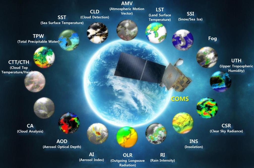
3 1. Introduction COMS status KMA hydrological products

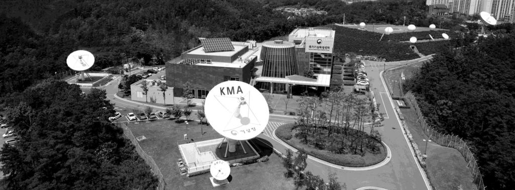
4 Located in E 4


5 - Combining Geo and Leo satellites 5
6 2. Hydrological Variables Soil Moisture Evapotranspiration
 LST spatial")


7 LST (COMS), NDVI (MODIS), Rainfall (AWS) LST spatial interpolation using Kriging method NDVI Low-peak correction Rainfall weighted average using Gaussian function Statistics analysis of In-situ Soil moisture NDVI Precipitation 7


 GLDAS")


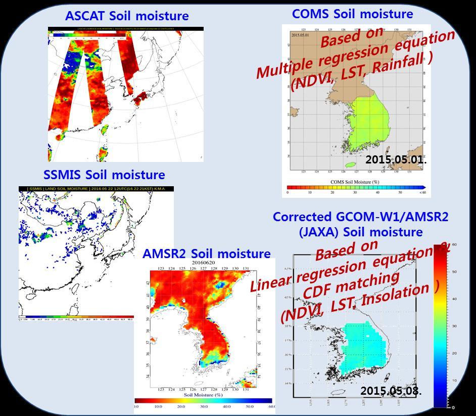
8 CDF matching between AMSR-2 and GLDAS Comparisons AMSR2 and GLDAS to In-situ GCOM-W1/AMSR2 (local time is 13:30) GLDAS every 3h (0600 UTC) Collocated data using nearest neighborhood method AMSR2 : 7 days moving average 8

: similar variation with in-situ SM")
: Reasonable scatter, well matched one-to-one line")
9 Linear Regression+CDF R: RMSE: Bias: In-situ GLDAS AMSR2 CDF Linear Regression R: RMSE: Bias: Time series Upper(Reg+CDF): similar variation with in-situ SM Lower(Reg): do not considered low SM domain(red arrow) Scatter plot Upper(Reg+CDF): Reasonable scatter, well matched one-to-one line Lower(Reg): overestimation < 0.2 m 3 /m 3, underestimation > 0.3 m 3 /m 3 9

, Hidden node(100),")
")
10 Using R studio, H2O library Feed-forward network Supervised (using Truth) feedback propagation Hidden layer(3), Hidden node(100), Epochs(3000) Gaussian distribution (response variable distribution) Rectifier activation function 10
11 Grid search with early stopping Tolerance: (improvement < 0.5% stop training, Mean Squared Error) Rounds: 3(average of recent 3 rounds compared with average of prior 3 rounds) Hidden RMSE R 2 R Epochs Hidden RMSE R 2 R Epochs [600, 600, 600, 600] [400, 400, 400, 400, 400] [700, 700, 700, 700] [400, 400, 400] [700, 700, 700] [300, 300, 300, 300] [600, 600, 600] [500, 500, 500, 500] [700, 700, 700, 700, 700, 700, 700] [400, 400, 400, 400, 400, 400, 400] [600, 600, 600, 600, 600] [400, 400, 400, 400, 400, 400] [300, 300, 300, 300, 300] [500, 500, 500, 500, 500, 500] [600, 600, 600, 600, 600, 600] [600, 600, 600, 600, 600, 600, 600] [500, 500, 500] [300, 300, 300, 300, 300, 300] [400, 400, 400, 400] [500, 500, 500, 500, 500] [500, 500, 500, 500, 500, 500, 500] [300, 300, 300, 300, 300, 300, 300] [700, 700, 700, 700, 700, 700] [300, 300, 300] [700, 700, 700, 700, 700]
 Deep learning SM Jincheon (R: 0.")
 DL GLDAS AMSR2 R 0.89 0.36 0.")


12 Youngcheon (R: 0.87/RMSE: 3.10/Bias: ) Deep learning SM Jincheon (R: 0.68/RMSE: 4.03/Bias: 0.376) DL GLDAS AMSR2 R RMSE Bias DL: relatively well matched with in-situ GLDAS: relatively high correlation with some bias AMSR2: different pattern with large bias 12


 Z 0 Canopy height low: Z")
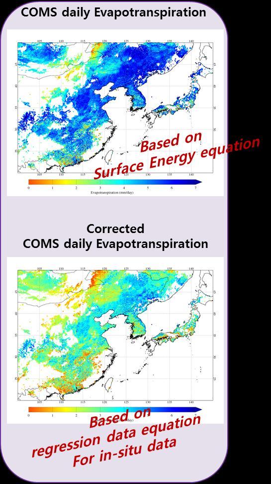
13 Based on the Surface Energy Equation COMS ET is characterized by simply simulated aerodynamic resistance, considering a variety of surface roughness length in the sensible heat flux (the so-called B-method of Jackson et al (1977)). Mapping Area : 20~50 N, 100~145 E (only clear skies, except on urban, desert area) Temporal/Spatial resolution : 1-day/1 km Estimation Period Z 0 Canopy height high: : April 1 ST 2011 ~ present Ecoclimap - Surface roughness (monthly) Z 0 Canopy height low: Z 0 =exp( NDVI) (Gupta et al., 2002) 13


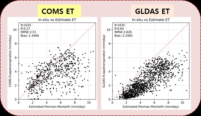
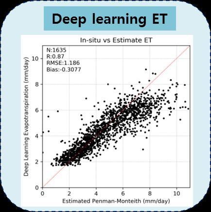
14 2012 COMS ET MODIS ET GLDAS ET N.obs R RMSE Bias COMS ET MODIS GLDAS N. obs R RMSE Bias ( ) COMS daily ET MODIS AET MODIS PET GLDAS ET 14
")
, Hidden node(72),")
")
15 R studio, H2O library/ Feed-forward network Supervised (using Truth) Error back propagation Hidden layer(3), Hidden node(72), Epochs(3000) Gaussian distribution (response variable distribution) Rectifier activation function 15

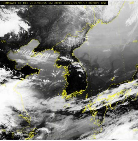
16 COMS ET Himawari-8 (Ch12) UTC 16
 Actual Evapotranspiration : COMS daily")
 - Simplified input data for")
 - Proposed for application in humid areas 2012.06.")
 γ:")
 G : Soil heat flux (MJ m -2 day -1 ) λ : Latent heat of")
17 Drought index (%) = AET/PET (Nicolas Ghilain, Royal Meteorological Institute, 2014) Actual Evapotranspiration : COMS daily Evapotranspiration Potential Evapotranspiration: COMS priestly-taylor Evapotranspiration (using COMS Ta, ins) - Simplified input data for estimating of evapotranspiration - Reference evapotranspiration (in grass conditions) - Proposed for application in humid areas COMS AET 16days α: Priestley-Taylor coefficient (dimensionless) : slope of the saturation vapour pressure curve (kpa C -1 ) γ: Psychrometric constant (kpa C -1 ) Rn : Net radiation (MJ m -2 day -1 ) G : Soil heat flux (MJ m -2 day -1 ) λ : Latent heat of vaporization COMS PET 16days 17
 Satellite based")


18 Reference data : MODIS VHI (Vegetation Health index, 16days) Satellite based meteorological-agriculture drought index Reflect on the Vegetation Condition Index (VCI) and Temperature Condition Index (TCI) Fig.1. KMA Drought Index. COMS AET/PET ratio : 16 days MODIS VHI : 16 days Fig.2. KMA average temperature of temperature anomaly during 30years Fig.3. KMA average rainfall of Rainfall anomaly during 30years The Possibility of COMS evapotranspiration Plan to comparison of land state index (LST, NDVI, NDWI, etc) 18
19 3. Future plan


, Snow (snow, snow depth)")
 - Radiation (upward, downward solar")

 - IR based soil moisture :")


 Vegetation Index Fraction")
20 COMS-2A is scheduled to launch on November 2018 COMS-2A will have 52 baseline products including hydrological variables GK-2A Products - Soil moisture, Vegetation Health Index - Land surface temperature, - Vegetation (VI, FVC), Snow (snow, snow depth) - Precipitation (potential precipitation, rainfall) - Radiation (upward, downward solar radiation, longwave radiation) - Flood detection Soil moisture - MW based on soil moisture : Low orbital satellite (AMSR2, SMOS, ASCAT) - IR based soil moisture : Geostationary satellite (COMS) - Deep learning based soil moisture using Himawari -8 Evapotranspiration - IR based evapotranspiration : COMS - Deep learning based evapotranspiration using Himawari-8(plan) Vegetation Index Fraction Vegetation Cover VHI (drougt index) IR based soil moisture Flood detection 20
21
EUMETSAT LSA-SAF EVAPOTRANSPIRATION PRODUCTS STATUS AND PERSPECTIVES
 EUMETSAT LSA-SAF EVAPOTRANSPIRATION PRODUCTS STATUS AND PERSPECTIVES Arboleda, N. Ghilain, F. Gellens-Meulenberghs Royal Meteorological Institute, Avenue Circulaire, 3, B-1180 Bruxelles, BELGIUM Corresponding
EVAPORATION GEOG 405. Tom Giambelluca
 EVAPORATION GEOG 405 Tom Giambelluca 1 Evaporation The change of phase of water from liquid to gas; the net vertical transport of water vapor from the surface to the atmosphere. 2 Definitions Evaporation:
Evapotranspiration monitoring with Meteosat Second Generation satellites: method, products and utility in drought detection.
 Evapotranspiration monitoring with Meteosat Second Generation satellites: method, products and utility in drought detection. Nicolas Ghilain Royal Meteorological Institute Belgium EUMeTrain Event week
Near Real-time Evapotranspiration Estimation Using Remote Sensing Data
 Near Real-time Evapotranspiration Estimation Using Remote Sensing Data by Qiuhong Tang 08 Aug 2007 Land surface hydrology group of UW Land Surface Hydrology Research Group ❶ ❷ ❸ ❹ Outline Introduction
Evaluation of a MODIS Triangle-based Algorithm for Improving ET Estimates in the Northern Sierra Nevada Mountain Range
 Evaluation of a MODIS Triangle-based Algorithm for Improving ET Estimates in the Northern Sierra Nevada Mountain Range Kyle R. Knipper 1, Alicia M. Kinoshita 2, and Terri S. Hogue 1 January 5 th, 2015
Jun Park National Meteorological Satellite Center Korea Meteorological Administration
 KMA Implementation Plan for Satellite Climate products Jun Park National Meteorological Satellite Center Korea Meteorological Administration jun.park@kma.go.kr Outline 1. Introduction : Current & Future
Indian National (Weather) SATellites for Agrometeorological Applications
 SATellites for Agrometeorological Applications") Indian National (Weather) SATellites for Agrometeorological Applications Bimal K. Bhattacharya Agriculture-Terrestrial Biosphere- Hydrology Group Space Applications Centre (ISRO) Ahmedabad 380015, India
Indian National (Weather) SATellites for Agrometeorological Applications Bimal K. Bhattacharya Agriculture-Terrestrial Biosphere- Hydrology Group Space Applications Centre (ISRO) Ahmedabad 380015, India
Satellite Soil Moisture Content Data Assimilation in Operational Local NWP System at JMA
 Satellite Soil Moisture Content Data Assimilation in Operational Local NWP System at JMA Yasutaka Ikuta Numerical Prediction Division Japan Meteorological Agency Acknowledgment: This research was supported
Assimilation of satellite derived soil moisture for weather forecasting
 Assimilation of satellite derived soil moisture for weather forecasting www.cawcr.gov.au Imtiaz Dharssi and Peter Steinle February 2011 SMOS/SMAP workshop, Monash University Summary In preparation of the
Validation of MODIS Data for Localized Spatio- Temporal Evapotranspiration Mapping
 IOP Conference Series: Earth and Environmental Science OPEN ACCESS Validation of MODIS Data for Localized Spatio- Temporal Evapotranspiration Mapping To cite this article: M I Nadzri and M Hashim 2014
Monitoring daily evapotranspiration in the Alps exploiting Sentinel-2 and meteorological data
 Monitoring daily evapotranspiration in the Alps exploiting Sentinel-2 and meteorological data M. Castelli, S. Asam, A. Jacob, M. Zebisch, and C. Notarnicola Institute for Earth Observation, Eurac Research,
Eric. W. Harmsen 1, John Mecikalski 2, Vanessa Acaron 3 and Jayson Maldonado 3
 Estimating Ground-Level Solar Radiation and Evapotranspiration In Puerto Rico Using Satellite Remote Sensing Eric. W. Harmsen 1, John Mecikalski 2, Vanessa Acaron 3 and Jayson Maldonado 3 1 Department
METRIC tm. Mapping Evapotranspiration at high Resolution with Internalized Calibration. Shifa Dinesh
 METRIC tm Mapping Evapotranspiration at high Resolution with Internalized Calibration Shifa Dinesh Outline Introduction Background of METRIC tm Surface Energy Balance Image Processing Estimation of Energy
Remote sensing derived evapotranspiration: comparisons to observations and models and results over the full MSG disk and selected basins
 4 th LSA-SAF WORKSHOP Toulouse,France, 15 th to 17 th November 2010 Remote sensing derived evapotranspiration: comparisons to observations and models and results over the full MSG disk and selected basins
Development of the Canadian Precipitation Analysis (CaPA) and the Canadian Land Data Assimilation System (CaLDAS)
 and the Canadian Land Data Assimilation System (CaLDAS)") Development of the Canadian Precipitation Analysis (CaPA) and the Canadian Land Data Assimilation System (CaLDAS) Marco L. Carrera, Vincent Fortin and Stéphane Bélair Meteorological Research Division Environment
Development of the Canadian Precipitation Analysis (CaPA) and the Canadian Land Data Assimilation System (CaLDAS) Marco L. Carrera, Vincent Fortin and Stéphane Bélair Meteorological Research Division Environment
Soil moisture retrieval with remote sensing images for debris flow forecast in humid regions
 Monitoring, Simulation, Prevention and Remediation of Dense and Debris Flows III 89 Soil moisture retrieval with remote sensing images for debris flow forecast in humid regions Y. Zhao 1,2,3, H. Yang 1,2
Remote Sensing Applications for Land/Atmosphere: Earth Radiation Balance
 Remote Sensing Applications for Land/Atmosphere: Earth Radiation Balance - Introduction - Deriving surface energy balance fluxes from net radiation measurements - Estimation of surface net radiation from
A methodology for estimation of surface evapotranspiration
 1 A methodology for estimation of surface evapotranspiration over large areas using remote sensing observations Le Jiang and Shafiqul Islam Cincinnati Earth Systems Science Program, Department of Civil
The role of soil moisture in influencing climate and terrestrial ecosystem processes
 1of 18 The role of soil moisture in influencing climate and terrestrial ecosystem processes Vivek Arora Canadian Centre for Climate Modelling and Analysis Meteorological Service of Canada Outline 2of 18
Evaporative Fraction and Bulk Transfer Coefficients Estimate through Radiometric Surface Temperature Assimilation
 Evaporative Fraction and Bulk Transfer Coefficients Estimate through Radiometric Surface Temperature Assimilation Francesca Sini, Giorgio Boni CIMA Centro di ricerca Interuniversitario in Monitoraggio
2. Irrigation. Key words: right amount at right time What if it s too little too late? Too much too often?
 2. Irrigation Key words: right amount at right time What if it s too little too late? 2-1 Too much too often? To determine the timing and amount of irrigation, we need to calculate soil water balance.
A SATELLITE LAND DATA ASSIMILATION SYTEM COUPLED WITH A MESOSCALE MODEL: TOWARDS IMPROVING NUMERICAL WEATHER PREDICTION
 A SATELLITE LAND DATA ASSIMILATION SYTEM COUPLED WITH A MESOSCALE MODEL: TOWARDS IMPROVING NUMERICAL WEATHER PREDICTION Mohamed Rasmy*, Toshio Koike*, Souhail Bousseta**, Xin Li*** Dept. of Civil Engineering,
Indian Journal of Hill Farming
 Content list available at http://epubs.icar.org.in, www.kiran.nic.in; ISSN: 0970-6429 Indian Journal of Hill Farming June 2016, Volume 29, Issue 1, Page 79-86 Evaluation of Methods for Estimation of Reference
Flux Tower Data Quality Analysis in the North American Monsoon Region
 Flux Tower Data Quality Analysis in the North American Monsoon Region 1. Motivation The area of focus in this study is mainly Arizona, due to data richness and availability. Monsoon rains in Arizona usually
School on Modelling Tools and Capacity Building in Climate and Public Health April Remote Sensing
 2453-5 School on Modelling Tools and Capacity Building in Climate and Public Health 15-26 April 2013 Remote Sensing CECCATO Pietro International Research Institute for Climate and Society, IRI The Earth
5. General Circulation Models
 5. General Circulation Models I. 3-D Climate Models (General Circulation Models) To include the full three-dimensional aspect of climate, including the calculation of the dynamical transports, requires
Indices and Indicators for Drought Early Warning
 Indices and Indicators for Drought Early Warning ADRIAN TROTMAN CHIEF, APPLIED METEOROLOGY AND CLIMATOLOGY CARIBBEAN INSTITUTE FOR METEOROLOGY AND HYDROLOGY IN COLLABORATION WITH THE NATIONAL DROUGHT MITIGATION
ECMWF. ECMWF Land Surface Analysis: Current status and developments. P. de Rosnay M. Drusch, K. Scipal, D. Vasiljevic G. Balsamo, J.
 Land Surface Analysis: Current status and developments P. de Rosnay M. Drusch, K. Scipal, D. Vasiljevic G. Balsamo, J. Muñoz Sabater 2 nd Workshop on Remote Sensing and Modeling of Surface Properties,
The Delaware Environmental Monitoring & Analysis Center
 The Delaware Environmental Monitoring & Analysis Center Tina Callahan Delaware Estuary Science & Environmental Summit 2013 January 27-30, 2013 What is DEMAC? Delaware Environmental Monitoring & Analysis
Eric. W. Harmsen 1, John Mecikalski 2, Pedro Tosado Cruz 1 Ariel Mercado Vargas 1
 Estimating Evapotranspiration using Satellite Remote Sensing in Puerto Rico, Haiti and the Dominican Republic Eric. W. Harmsen 1, John Mecikalski 2, Pedro Tosado Cruz 1 Ariel Mercado Vargas 1 1. University
ASSESSMENT OF DIFFERENT WATER STRESS INDICATORS BASED ON EUMETSAT LSA SAF PRODUCTS FOR DROUGHT MONITORING IN EUROPE
 ASSESSMENT OF DIFFERENT WATER STRESS INDICATORS BASED ON EUMETSAT LSA SAF PRODUCTS FOR DROUGHT MONITORING IN EUROPE G. Sepulcre Canto, A. Singleton, J. Vogt European Commission, DG Joint Research Centre,
Evapotranspiration: Theory and Applications
 Evapotranspiration: Theory and Applications Lu Zhang ( 张橹 ) CSIRO Land and Water Evaporation: part of our everyday life Evapotranspiration Global Land: P = 800 mm Q = 315 mm E = 485 mm Evapotranspiration
Evaluation of a New Land Surface Model for JMA-GSM
 Evaluation of a New Land Surface Model for JMA-GSM using CEOP EOP-3 reference site dataset Masayuki Hirai Takuya Sakashita Takayuki Matsumura (Numerical Prediction Division, Japan Meteorological Agency)
GEOG415 Mid-term Exam 110 minute February 27, 2003
 GEOG415 Mid-term Exam 110 minute February 27, 2003 1 Name: ID: 1. The graph shows the relationship between air temperature and saturation vapor pressure. (a) Estimate the relative humidity of an air parcel
Customizable Drought Climate Service for supporting different end users needs
 1 Customizable Drought Climate Service for supporting different end users needs Ramona MAGNO, T. De Filippis, E. Di Giuseppe, M. Pasqui, E. Rapisardi, L. Rocchi (IBIMET-CNR; LaMMA Consortium) 1 Congresso
Estimation of Wavelet Based Spatially Enhanced Evapotranspiration Using Energy Balance Approach
 Estimation of Wavelet Based Spatially Enhanced Evapotranspiration Using Energy Balance Approach Dr.Gowri 1 Dr.Thirumalaivasan 2 1 Associate Professor, Jerusalem College of Engineering, Department of Civil
The Application of Satellite Data i n the Global Surface Data Assimil ation System at KMA
 The Application of Satellite Data i n the Global Surface Data Assimil ation System at KMA Mee-Ja Kim, Hae-Mi Noh, SeiYoung Park, Sangwon Joo KMA/NIMS kimmee74@korea.kr 14 March, 2016 The 4th Workshop on
Estimating Evaporation : Principles, Assumptions and Myths. Raoul J. Granger, NWRI
 Estimating Evaporation : Principles, Assumptions and Myths Raoul J. Granger, NWRI Evaporation So what is it anyways? Evaporation is the phenomenon by which a substance is converted from the liquid or solid
ECMWF. ECMWF Land Surface modelling and land surface analysis. P. de Rosnay G. Balsamo S. Boussetta, J. Munoz Sabater D.
 Land Surface modelling and land surface analysis P. de Rosnay G. Balsamo S. Boussetta, J. Munoz Sabater D. Vasiljevic M. Drusch, K. Scipal SRNWP 12 June 2009 Slide 1 Surface modelling (G. Balsamo) HTESSEL,
Promoting Rainwater Harvesting in Caribbean Small Island Developing States Water Availability Mapping for Grenada Preliminary findings
 Promoting Rainwater Harvesting in Caribbean Small Island Developing States Water Availability Mapping for Grenada Preliminary findings National Workshop Pilot Project funded by The United Nations Environment
GCOM-W1 now on the A-Train
 GCOM-W1 now on the A-Train GCOM-W1 Global Change Observation Mission-Water Taikan Oki, K. Imaoka, and M. Kachi JAXA/EORC (& IIS/The University of Tokyo) Mini-Workshop on A-Train Science, March 8 th, 2013
The Canadian Land Data Assimilation System (CaLDAS)
") The Canadian Land Data Assimilation System (CaLDAS) Marco L. Carrera, Stéphane Bélair, Bernard Bilodeau and Sheena Solomon Meteorological Research Division, Environment Canada Dorval, QC, Canada 2 nd Workshop
The Canadian Land Data Assimilation System (CaLDAS) Marco L. Carrera, Stéphane Bélair, Bernard Bilodeau and Sheena Solomon Meteorological Research Division, Environment Canada Dorval, QC, Canada 2 nd Workshop
Radiation, Sensible Heat Flux and Evapotranspiration
 Radiation, Sensible Heat Flux and Evapotranspiration Climatological and hydrological field work Figure 1: Estimate of the Earth s annual and global mean energy balance. Over the long term, the incoming
NCEP Land-Surface Modeling
 NCEP Land-Surface Modeling Michael Ek and the EMC Land-Hydrology Team Environmental Modeling Center (EMC) National Centers for Environmental Prediction (NCEP) 5200 Auth Road, Room 207 Suitland, Maryland
The Two Source Energy Balance model using satellite, airborne and proximal remote sensing
 The using satellite, airborne and proximal remote sensing 7 years in a relationship Héctor Nieto Hector.nieto@irta.cat Resistance Energy Balance Models (REBM) E R e n H G Physics based on an analogy to
Eric. W. Harmsen Agricultural and Biosystems Engineering Department, University of Puerto Rico Mayaguez Campus
 AN OPERATIONAL WATER AND ENERGY BALANCE ALGORITHM FOR PUERTO RICO Eric. W. Harmsen Agricultural and Biosystems Engineering Department, University of Puerto Rico Mayaguez Campus DÉCIMA REUNIÓN NACIONAL
Soil Water Atmosphere Plant (SWAP) Model: I. INTRODUCTION AND THEORETICAL BACKGROUND
 Model: I. INTRODUCTION AND THEORETICAL BACKGROUND") Soil Water Atmosphere Plant (SWAP) Model: I. INTRODUCTION AND THEORETICAL BACKGROUND Reinder A.Feddes Jos van Dam Joop Kroes Angel Utset, Main processes Rain fall / irrigation Transpiration Soil evaporation
Soil Water Atmosphere Plant (SWAP) Model: I. INTRODUCTION AND THEORETICAL BACKGROUND Reinder A.Feddes Jos van Dam Joop Kroes Angel Utset, Main processes Rain fall / irrigation Transpiration Soil evaporation
Thermal Crop Water Stress Indices
 Page 1 of 12 Thermal Crop Water Stress Indices [Note: much of the introductory material in this section is from Jackson (1982).] The most established method for detecting crop water stress remotely is
Evapotranspiration. Here, liquid water on surfaces or in the very thin surface layer of the soil that evaporates directly to the atmosphere
 Evapotranspiration Evaporation (E): In general, the change of state from liquid to gas Here, liquid water on surfaces or in the very thin surface layer of the soil that evaporates directly to the atmosphere
SMAP and SMOS Integrated Soil Moisture Validation. T. J. Jackson USDA ARS
 SMAP and SMOS Integrated Soil Moisture Validation T. J. Jackson USDA ARS Perspective Linkage of SMOS and SMAP soil moisture calibration and validation will have short and long term benefits for both missions.
Surface issues for High Resolution NWP
 Surface issues for High Resolution NWP François Bouyssel - Jean-François Mahfouf with many contributors High Resolution NWP Workshop, 17-20 May 2010, Brac, Croatia Outline Introduction (specificities of
Estimation of Reference Evapotranspiration by Artificial Neural Network
 Estimation of Reference Evapotranspiration by Artificial Neural Network A. D. Bhagat 1, P. G. Popale 2 PhD Scholar, Department of Irrigation and Drainage Engineering, Dr. ASCAE&T, Mahatma Phule Krishi
Land Surface Processes and Their Impact in Weather Forecasting
 Land Surface Processes and Their Impact in Weather Forecasting Andrea Hahmann NCAR/RAL with thanks to P. Dirmeyer (COLA) and R. Koster (NASA/GSFC) Forecasters Conference Summer 2005 Andrea Hahmann ATEC
Use of satellite soil moisture information for NowcastingShort Range NWP forecasts
 Use of satellite soil moisture information for NowcastingShort Range NWP forecasts Francesca Marcucci1, Valerio Cardinali/Paride Ferrante1,2, Lucio Torrisi1 1 COMET, Italian AirForce Operational Center
Aquarius/SAC-D Soil Moisture Product using V3.0 Observations
 Aquarius/SAC-D Soil Moisture Product using V3. Observations R. Bindlish, T. Jackson, M. Cosh November 214 Overview Soil moisture algorithm Soil moisture product Validation Linkage between Soil Moisture
NOAA Soil Moisture Operational Product System (SMOPS): Version 2
: Version 2") CICS-MD Science Meeting (November 12-13, 2014) NOAA Soil Moisture Operational Product System (SMOPS): Version 2 Jicheng Liu 1, 2, Xiwu Zhan 2, Limin Zhao 3, Christopher R. Hain 1, 2, Li Fang 1,2, Jifu
CICS-MD Science Meeting (November 12-13, 2014) NOAA Soil Moisture Operational Product System (SMOPS): Version 2 Jicheng Liu 1, 2, Xiwu Zhan 2, Limin Zhao 3, Christopher R. Hain 1, 2, Li Fang 1,2, Jifu
WATER AND ENERGY BALANCE ESTIMATION IN PUERTO RICO USING SATELLITE REMOTE SENSING
 WATER AND ENERGY BALANCE ESTIMATION IN PUERTO RICO USING SATELLITE REMOTE SENSING Eric. W. Harmsen, Ariel Mercado Vargas, Pedro Tosado Cruz, Jonellys M Maldonado Morales and Angel O. Ortiz Lozada OCTAVA
Land Data Assimilation at NCEP NLDAS Project Overview, ECMWF HEPEX 2004
 Dag.Lohmann@noaa.gov, Land Data Assimilation at NCEP NLDAS Project Overview, ECMWF HEPEX 2004 Land Data Assimilation at NCEP: Strategic Lessons Learned from the North American Land Data Assimilation System
Flux Tower Data Quality Analysis. Dea Doklestic
 Flux Tower Data Quality Analysis Dea Doklestic Motivation North American Monsoon (NAM) Seasonal large scale reversal of atmospheric circulation Occurs during the summer months due to a large temperature
DroughtWatch system operation in Mongolia
 REGIONAL WORKSHOP ON UNDERSTANDING THE OPERATIONAL ASPECTS OF THE DROUGHT OBSERVATION SYSTEM IN MONGOLIA DroughtWatch system operation in Mongolia Dr. Munkhzul Dorjsuren Remote Sensing Specilist, IRIMHE
Current status of lake modelling and initialisation at ECMWF
 Current status of lake modelling and initialisation at ECMWF G Balsamo, A Manrique Suñen, E Dutra, D. Mironov, P. Miranda, V Stepanenko, P Viterbo, A Nordbo, R Salgado, I Mammarella, A Beljaars, H Hersbach
Land Data Assimilation for operational weather forecasting
 Land Data Assimilation for operational weather forecasting Brett Candy Richard Renshaw, JuHyoung Lee & Imtiaz Dharssi * *Centre Australian Weather and Climate Research Contents An overview of the Current
Water Balance in the Murray-Darling Basin and the recent drought as modelled with WRF
 18 th World IMACS / MODSIM Congress, Cairns, Australia 13-17 July 2009 http://mssanz.org.au/modsim09 Water Balance in the Murray-Darling Basin and the recent drought as modelled with WRF Evans, J.P. Climate
ONE DIMENSIONAL CLIMATE MODEL
 JORGE A. RAMÍREZ Associate Professor Water Resources, Hydrologic and Environmental Sciences Civil Wngineering Department Fort Collins, CO 80523-1372 Phone: (970 491-7621 FAX: (970 491-7727 e-mail: Jorge.Ramirez@ColoState.edu
A Facility for Producing Consistent Remotely Sensed Biophysical Data Products of Australia
 TERRESTRIAL ECOSYSTEM RESEARCH NETWORK - AusCover - A Facility for Producing Consistent Remotely Sensed Biophysical Data Products of Australia June, 2011 Mervyn Lynch Professor of Remote Sensing Curtin
GE G Climate Science Lab
 GE G Climate Science Lab North American Soil Moisture Database: Development and Applications Steven M. Quiring Texas A&M University Trenton Ford Texas A&M University http://climatology.tamu.edu http://facebook.com/geogcsl
Mapping Evapotranspiration and Drought at Local to Continental Scales Using Thermal Remote Sensing
 Mapping Evapotranspiration and Drought at Local to Continental Scales Using Thermal Remote Sensing M.C. Anderson, W.P. Kustas USDA-ARS, Hydrology and Remote Sensing Laboratory J.M Norman University of
School on Modelling Tools and Capacity Building in Climate and Public Health April Rainfall Estimation
 2453-6 School on Modelling Tools and Capacity Building in Climate and Public Health 15-26 April 2013 Rainfall Estimation CECCATO Pietro International Research Institute for Climate and Society, IRI The
Contents. 1. Evaporation
 Contents 1 Evaporation 1 1a Evaporation from Wet Surfaces................... 1 1b Evaporation from Wet Surfaces in the absence of Advection... 4 1c Bowen Ratio Method........................ 4 1d Potential
Assimilation of ASCAT soil wetness
 EWGLAM, October 2010 Assimilation of ASCAT soil wetness Bruce Macpherson, on behalf of Imtiaz Dharssi, Keir Bovis and Clive Jones Contents This presentation covers the following areas ASCAT soil wetness
Supplement of Upside-down fluxes Down Under: CO 2 net sink in winter and net source in summer in a temperate evergreen broadleaf forest
 Supplement of Biogeosciences, 15, 3703 3716, 2018 https://doi.org/10.5194/bg-15-3703-2018-supplement Author(s) 2018. This work is distributed under the Creative Commons Attribution 4.0 License. Supplement
ROBUST EVAPORATION ESTIMATES: RESULTS FROM A COLLABORATIVE PROJECT
 ROBUST EVAPORATION ESTIMATES: RESULTS FROM A COLLABORATIVE PROJECT MG MCGLINCHEY 1 AND NG INMAN-BAMBER 1 Swaziland Sugar Association Technical Services, Simunye, Swaziland CSIRO, Davies Lab, Townsville,
John R. Mecikalski #1, Martha C. Anderson*, Ryan D. Torn #, John M. Norman*, George R. Diak #
 P4.22 THE ATMOSPHERE-LAND EXCHANGE INVERSE (ALEXI) MODEL: REGIONAL- SCALE FLUX VALIDATIONS, CLIMATOLOGIES AND AVAILABLE SOIL WATER DERIVED FROM REMOTE SENSING INPUTS John R. Mecikalski #1, Martha C. Anderson*,
VIC Hydrology Model Training Workshop Part II: Building a model
 VIC Hydrology Model Training Workshop Part II: Building a model 11-12 Oct 2011 Centro de Cambio Global Pontificia Universidad Católica de Chile Ed Maurer Civil Engineering Department Santa Clara University
Pan evaporation in Hong Kong
 Pan evaporation in Hong Kong John K. W. Chan Hong Kong Observatory, Kowloon, Hong Kong In 1957, the Hong Kong Observatory installed two evaporation pans at the King s Park Meteorological Station in Kowloon,
Surface temperature what does this data tell us about micro-meteorological processes?
 Surface temperature what does this data tell us about micro-meteorological processes? Prof. Dr. Eberhard Parlow Meteorology, Climatology and Remote Sensing (MCR Lab) Department of Environmental Sciences
Amita Mehta and Ana Prados
 Building Capacity in Utilizing NASA Remote Sensing Observations in SWAT for Water Resources and Agricultural Management Applications Amita Mehta and Ana Prados NASA - University of Maryland Baltimore County
Bugs in JRA-55 snow depth analysis
 14 December 2015 Climate Prediction Division, Japan Meteorological Agency Bugs in JRA-55 snow depth analysis Bugs were recently found in the snow depth analysis (i.e., the snow depth data generation process)
LSA SAF evapotranspiration products and on going research at RMI
 WMO RAVI Hydrological Forum 2016 Workshop on hydrological modelling, forecasting and warnings 20 September 2016, Oslo, Norway LSA SAF evapotranspiration products and on going research at RMI by Françoise
Remote sensing estimates of actual evapotranspiration in an irrigation district
 Engineers Australia 29th Hydrology and Water Resources Symposium 21 23 February 2005, Canberra Remote sensing estimates of actual evapotranspiration in an irrigation district Cressida L. Department of
Toward improving the representation of the water cycle at High Northern Latitudes
 Toward improving the representation of the water cycle at High Northern Latitudes W. A. Lahoz a, T. M. Svendby a, A. Griesfeller a, J. Kristiansen b a NILU, Kjeller, Norway b Met Norway, Oslo, Norway wal@nilu.no
Evaluation of Satellite and Reanalysis Products of Downward Surface Solar Radiation over East Asia
 International Workshop on Land Use/Cover Changes and Air Pollution in Asia August 4-7th, 2015, Bogor, Indonesia Evaluation of Satellite and Reanalysis Products of Downward Surface Solar Radiation over
Land data assimilation in the NASA GEOS-5 system: Status and challenges
 Blueprints for Next-Generation Data Assimilation Systems Boulder, CO, USA 8-10 March 2016 Land data assimilation in the NASA GEOS-5 system: Status and challenges Rolf Reichle Clara Draper, Ricardo Todling,
A 2016 CEOS Chair Initiative. Non-meteorological Applications for Next Generation Geostationary Satellites
 A 2016 CEOS Chair Initiative Committee on Earth Observation Satellites Non-meteorological Applications for Next Generation Geostationary Satellites Co-chaired by EUMETSAT (Holmlund), CSIRO (Schroeder),
Global Water Cycle. Surface (ocean and land): source of water vapor to the atmosphere. Net Water Vapour Flux Transport 40.
: source of water vapor to the atmosphere. Net Water Vapour Flux Transport 40.") Global Water Cycle Surface (ocean and land): source of water vapor to the atmosphere Water Vapour over Land 3 Net Water Vapour Flux Transport 40 Water Vapour over Sea 10 Glaciers and Snow 24,064 Permafrost
Global Water Cycle Surface (ocean and land): source of water vapor to the atmosphere Water Vapour over Land 3 Net Water Vapour Flux Transport 40 Water Vapour over Sea 10 Glaciers and Snow 24,064 Permafrost
Regional offline land surface simulations over eastern Canada using CLASS. Diana Verseghy Climate Research Division Environment Canada
 Regional offline land surface simulations over eastern Canada using CLASS Diana Verseghy Climate Research Division Environment Canada The Canadian Land Surface Scheme (CLASS) Originally developed for the
GFAS Methodology & Results
 GFAS Methodology & Results Johannes W. Kaiser, Imke Hüser, Berit Gehrke Max Planck Institute for Chemistry, DE Tadas Nikonovas, Weidong Xu, Martin G. Wooster King s College London, UK Ioannis Bistinas,
Dependence of evaporation on meteorological variables at di erent time-scales and intercomparison of estimation methods
 Hydrological Processes Hydrol. Process. 12, 429±442 (1998) Dependence of evaporation on meteorological variables at di erent time-scales and intercomparison of estimation methods C.-Y. Xu 1 and V.P. Singh
ESTIMATION OF ATMOSPHERIC COLUMN AND NEAR SURFACE WATER VAPOR CONTENT USING THE RADIANCE VALUES OF MODIS
 ESTIMATION OF ATMOSPHERIC COLUMN AND NEAR SURFACE WATER VAPOR CONTENT USIN THE RADIANCE VALUES OF MODIS M. Moradizadeh a,, M. Momeni b, M.R. Saradjian a a Remote Sensing Division, Centre of Excellence
High resolution land reanalysis
 Regional Reanalysis Workshop 19-20 May 2016, Reading High resolution land reanalysis P. de Rosnay, G. Balsamo, J. Muñoz Sabater, E. Dutra, C. Albergel, N. Rodríguez-Fernández, H. Hersbach Introduction:
P1.34 MULTISEASONALVALIDATION OF GOES-BASED INSOLATION ESTIMATES. Jason A. Otkin*, Martha C. Anderson*, and John R. Mecikalski #
 P1.34 MULTISEASONALVALIDATION OF GOES-BASED INSOLATION ESTIMATES Jason A. Otkin*, Martha C. Anderson*, and John R. Mecikalski # *Cooperative Institute for Meteorological Satellite Studies, University of
APPLICATION OF BACKPROPAGATION NEURAL NETWORK TO ESTIMATE EVAPOTRANSPIRATION FOR CHIANAN IRRIGATED AREA, TAIWAN
 USCID Fourth International Conference 1253 APPLICATION OF BACKPROPAGATION NEURAL NETWORK TO ESTIMATE EVAPOTRANSPIRATION FOR CHIANAN IRRIGATED AREA, TAIWAN Sheng-Feng Kuo 1 Ming-Hua Tsai 2 Wei-Taw Lin 3
Soil Moisture Prediction and Assimilation
 Soil Moisture Prediction and Assimilation Analysis and Prediction in Agricultural Landscapes Saskatoon, June 19-20, 2007 STEPHANE BELAIR Meteorological Research Division Prediction and Assimilation Atmospheric
11 days (00, 12 UTC) 132 hours (06, 18 UTC) One unperturbed control forecast and 26 perturbed ensemble members. --
 132 hours (06, 18 UTC) One unperturbed control forecast and 26 perturbed ensemble members. --") APPENDIX 2.2.6. CHARACTERISTICS OF GLOBAL EPS 1. Ensemble system Ensemble (version) Global EPS (GEPS1701) Date of implementation 19 January 2017 2. EPS configuration Model (version) Global Spectral Model
APPENDIX 2.2.6. CHARACTERISTICS OF GLOBAL EPS 1. Ensemble system Ensemble (version) Global EPS (GEPS1701) Date of implementation 19 January 2017 2. EPS configuration Model (version) Global Spectral Model
Remote Sensing for Water Resource Management
 Remote Sensing for Water Resource Management Natascha Oppelt Kiel University Department of Geography Kiel University Ludewig-Meyn-Str 14 Department for Geography 24098 Kiel oppelt@geographie.uni-kiel.de
Use of satellite information in research and operational activities at NIMH of Bulgaria
 Use of satellite information in research and operational activities at NIMH of Bulgaria Rilka Valcheva NIMH, Bulgaria WMO/EUMETSAT Satellite Products Training Course 24-28 April 2017, Budapest, Hungary
Evaporation and Evapotranspiration
 Evaporation and Evapotranspiration Wossenu Abtew Assefa Melesse Evaporation and Evapotranspiration Measurements and Estimations 123 Dr. Wossenu Abtew South Florida Water Management District West Palm
HydroUmcal Interactions Between Atmosphere, Soil and Vernation (Proceedings of the Vienna Symposium, August 1991). IAHS Publ. no. 204,1991.
. IAHS Publ. no. 204,1991.") HydroUmcal Interactions Between Atmosphere, Soil and Vernation (Proceedings of the Vienna Symposium, August 1991). IAHS Publ. no. 204,1991. Theoretical and Experimental Analysis of the Relationship Between
HydroUmcal Interactions Between Atmosphere, Soil and Vernation (Proceedings of the Vienna Symposium, August 1991). IAHS Publ. no. 204,1991. Theoretical and Experimental Analysis of the Relationship Between
THE ROLE OF MICROSTRUCTURE IN FORWARD MODELING AND DATA ASSIMILATION SCHEMES: A CASE STUDY IN THE KERN RIVER, SIERRA NEVADA, USA
 MICHAEL DURAND (DURAND.8@OSU.EDU), DONGYUE LI, STEVE MARGULIS Photo: Danielle Perrot THE ROLE OF MICROSTRUCTURE IN FORWARD MODELING AND DATA ASSIMILATION SCHEMES: A CASE STUDY IN THE KERN RIVER, SIERRA
Planning for next generation geostationary satellites (GK-2A) of Korea Meteorological Administration (KMA)
 of Korea Meteorological Administration (KMA)") Planning for next generation geostationary satellites (GK-2A) of Korea Meteorological Administration (KMA) Yunbok Lee & Geun-Hyeok Ryu 1 NMSC Goal To operate timely COMS, to gather reliable satellite data
Planning for next generation geostationary satellites (GK-2A) of Korea Meteorological Administration (KMA) Yunbok Lee & Geun-Hyeok Ryu 1 NMSC Goal To operate timely COMS, to gather reliable satellite data