Eric. W. Harmsen 1, John Mecikalski 2, Pedro Tosado Cruz 1 Ariel Mercado Vargas 1
|
|
|
- Austin Lamb
- 6 years ago
- Views:
Transcription

1 Estimating Evapotranspiration using Satellite Remote Sensing in Puerto Rico, Haiti and the Dominican Republic Eric. W. Harmsen 1, John Mecikalski 2, Pedro Tosado Cruz 1 Ariel Mercado Vargas 1 1. University of Puerto Rico Mayaguez 2. University of Alabama - Huntsville The 46th Annual Meeting of the Caribbean Food Crops Society, July 12, 2010 USDA Hatch


2 Evapotranspiration (ET) In Agriculture Optimal crop yield depends on providing the plants potential ET via rainfall or irrigation. In Water Resources Planning ET strongly influences aquifer recharge, surface runoff and stream flow


3 Currently situation in Puerto Rico Estimation of ET requires weather data, including solar radiation In PR, solar radiation is only available at selected locations. The majority of the UPR Experiment Stations are currently not measuring solar radiation A number of the radiation sensors are PAR sensors and are not appropriate for use in ET equations. At this time there are approximately fifteen functional solar radiation sensors (pyranometers) in Puerto Rico.
 is like having 9,000 pyranometers in Puerto Rico!")

4 Since Puerto Rico s land area is approximately 9,000 km 2, estimating solar radiation using remote sensing (assuming a 1 km 2 satellite resolution) is like having 9,000 pyranometers in Puerto Rico!! Satellite Remote Sensing Estimate solar radiation Estimate ET Remote sensing of solar radiation has several advantages over the use of pyranometer networks Large spatial coverage Relatively high spatial resolution Availability of data in remote areas Data (or maps) can be made easily accessible to the public via the Internet

5 OBJECTIVE To introduce several new water resourcerelated remote sensing products for Puerto Rico, Haiti and the Dominican Republic. The development of the methodology has advanced more quickly in Puerto Rico, therefore, the information presented here can be considered a prototype of what is being developed for the other two countries (i.e., Haiti and the Dominican Republic).
6 Technical Approach
7 Remotely Sensed Solar Radiation Solar radiation was obtained using the Modified Gautier and Diak method (Gautier et al., 1980; Diak and Gautier, 1983). Data were obtained from the GOES-East satellite. Geostationary platform 1 km resolution visible channel 2 km Haiti and the Dominican Republic High time resolution (30 minutes)
8 Remotely Sensed Solar Radiation (MJ/m 2 /day) A calibrated, high-resolution GOES satellite solar insolation product for a climatology of Florida Evapotranspiration (Paech et al., 2009) Measured Solar Radiation (MJ/m 2 /day)
9 Solar Radiation (MJ/m 2 day) Comparison of remotely sensed and measured solar radiation at Fortuna, PR, during the period April 1 through June 21, Apr Apr May Jun-09 Date Estimated Solar Radiation Observed Solar Radiation

10 How do we solve remote sensing problems?
11 Hargreaves Equation for Reference Evapotranspiration ET o = R s (T+17.8) ET o is reference evapotranspiration R s is daily integrated solar radiation (insolation) T is mean temperature
12 Actual Evapotranspiration ET a = λ LE λ is the Latent Heat of Vaporization (2.45 MJ/kg) LE is the Latent Heat Flux
13 Surface Energy Balance R n LE H G = 0 R n is net radiation LE is the latent heat flux H is the sensible heat flux G is soil heat flux, assumed to be zero for 24 hour analysis. The only unknown variable in the above equation is the effective surface temperature T s. We solve for T s using the fzero function in MatLab

14 Latent Heat Flux LE C p e o T s et a r a r s. LE is the latent heat flux ρ is density of dry air C p is specifc heat of air γ is the psychrometric constant e is vapor pressure T s is effective surface temperature T a is the air temperature r a is aerodynamic resistance r s is surface resistance
15 Sensible Heat Flux H C p T s T a. r a HE is the Sensible Heat Flux ρ is density of dry air C p is specifc heat of air T s is effective surface temperature T a is the air temperature r a is aerodynamic resistance
16 Aerodynamic Resistance (r a ) r a r ao r bh. r a is aerodynamic resistance r ao is aerodynamic resistance under conditions of neutral atmospheric stability ϕ is stability coefficient r bh is excess resistance
17 Aerodynamic Resistance (r a ) r ao ln z z disp z o ln z z disp ( 0.1) z o k 2 u. r ao is aerodynamic resistance under conditions of neutral atmospheric stability z is height at which meteorologic measurements are taken Z disp is zero plane displacement Z o is roughness length K is Van Karman constant (0.41) u is wind velocity
18 Stability Coefficient (ϕ) 1 z z disp T o u 2 g T s T a. ϕ is stability constant η is a constant commonly taken as 5 z height at which meteorological measurements are taken g gravitational constant Z disp is zero plane displacement T s is effective surface temperature T a is air temperature T o is average of T s and T a u is wind velocity
19 Water Balance SMD2 = PRECIP ET a RO DP + SMD1 SMD1 and SMD2 are the soil moisture content at beginning and end of the 24 hour period PRECIP is the rainfall during the day ETa is daily actual evapotranspiration RO is surface runoff DP is deep percolation
20 Surface Runoff (RO) RO = (PRECIP 0.2S) 2 / (PRECIP + 0.8S) S = [(25400 / CN) 254] RO is surface runoff PRECIP is rainfall S is the maximum potential difference between rainfall and runoff at the moment of rainfall initiation CN is the curve number which is a proportion of rainfall converted to runoff
21 Soil Moisture and Deep Perclation An initial value of SMD2 is calculated with a modification of water balance equation: SMD2 i = PRECIP ET a RO + SMD1. If the Value of SMD2 i is larger than the depth of water in the profile at field capacity (FCD), then DP = SMD2 i - FCD and the value of SMD2 is equal to FCD. If however, SMD2 i < FCD, then DP = 0, and SMD2 = SMD2 i.

22 RESULTS An analysis was performed for a10 day period between June 20 and June 29, The soil moisture was adjusted daily based on the surface water balance Images are shown for June 29, 2010


23 Field Capacity Wilting Point


24 Percent Sand, Percent Silt Percent Clay
25 Land Cover Zero Plane Displacement Surface Roughness


26 Root depth CN number


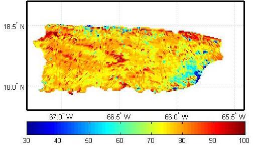
27 Estimated reference evapotranspiration (ET o ) for Puerto Rico on June 29 th, 2010.

28 Estimated reference evapotranspiration (ET o ) for Haiti and the Dominican Republic on June 29 th, Haiti Dominican Republic
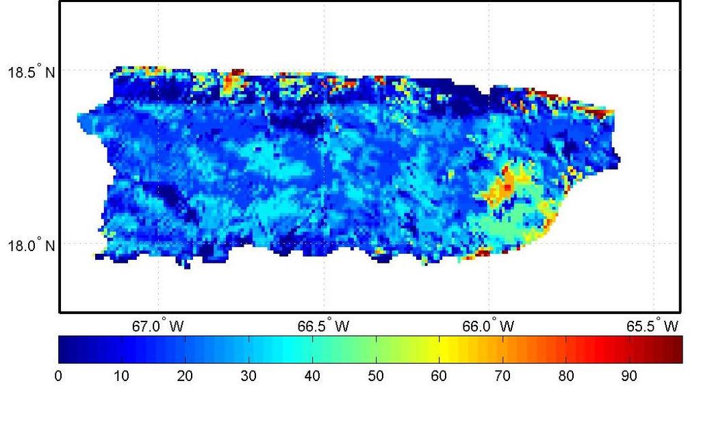
29 Estimated actual evapotranspiration (ET a ) for Puerto Rico on June 29 th, 2010.

30 Wind Speed (m/s) (National Weather Service s National Digital Forecast Database ).
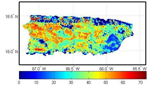
31 Estimate crop coefficient (K c ) over Puerto Rico on June 29, 2010.

32 Rainfall over Puerto Rico on June 29, 2010 (NOAA s Advance Hydrologic Prediction Services).
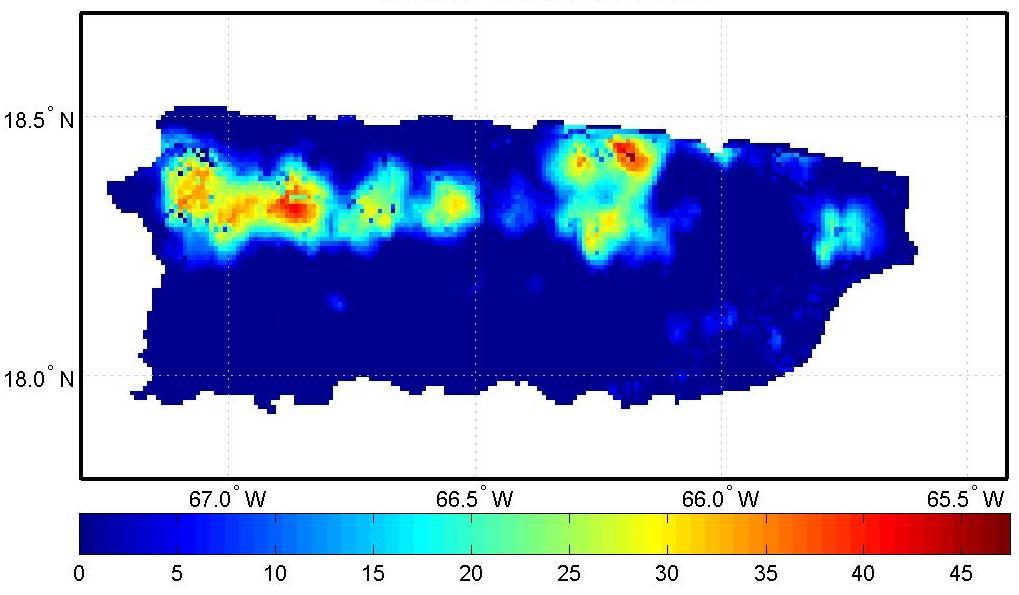
33 Estimated surface runoff in Puerto Rico on June 29, 2010.

34 Estimated deep percolation on June 29, 2010.
35 Estimated soil moisture in Puerto Rico on June 29, 2010.
36 Summary and Conclusions We describe a method for estimating reference evapotranspiration in Puerto Rico, Haiti and the Dominican Republic. Methods for estimating the actual evapotranspiration and the hydrologic water balance over Puerto Rico were also described. Estimates of reference evapotranspiration for June 29, 2010, were provided for Puerto Rico, Haiti and the Dominican Republic, Estimated actual evapotranspiration, surface runoff, deep percolation and soil moisture content for Puerto Rico for the same day were presented.
37 Acknowledgements Financial Support: USDA-Hatch (H-402) NOAA-CREST (NA17AE1625) NSF-CASA (NSF )
WATER AND ENERGY BALANCE ESTIMATION IN PUERTO RICO USING SATELLITE REMOTE SENSING
 WATER AND ENERGY BALANCE ESTIMATION IN PUERTO RICO USING SATELLITE REMOTE SENSING Eric. W. Harmsen, Ariel Mercado Vargas, Pedro Tosado Cruz, Jonellys M Maldonado Morales and Angel O. Ortiz Lozada OCTAVA
Eric. W. Harmsen 1, John Mecikalski 2, Vanessa Acaron 3 and Jayson Maldonado 3
 Estimating Ground-Level Solar Radiation and Evapotranspiration In Puerto Rico Using Satellite Remote Sensing Eric. W. Harmsen 1, John Mecikalski 2, Vanessa Acaron 3 and Jayson Maldonado 3 1 Department
Eric. W. Harmsen Agricultural and Biosystems Engineering Department, University of Puerto Rico Mayaguez Campus
 AN OPERATIONAL WATER AND ENERGY BALANCE ALGORITHM FOR PUERTO RICO Eric. W. Harmsen Agricultural and Biosystems Engineering Department, University of Puerto Rico Mayaguez Campus DÉCIMA REUNIÓN NACIONAL
Estimating Daily Evapotranspiration in Puerto Rico using Satellite Remote Sensing
 Estimating Daily Evapotranspiration in Puerto Rico using Satellite Remote Sensing ERIC. W. HARMSEN 1, JOHN MECIKALSKI 2, MELVIN J. CARDONA-SOTO 3, ALEJANDRA ROJAS GONZALEZ 4 AND RAMÓN VASQUEZ 5 1 Department
Research Note COMPUTER PROGRAM FOR ESTIMATING CROP EVAPOTRANSPIRATION IN PUERTO RICO 1,2. J. Agric. Univ. P.R. 89(1-2): (2005)
: (2005)") Research Note COMPUTER PROGRAM FOR ESTIMATING CROP EVAPOTRANSPIRATION IN PUERTO RICO 1,2 Eric W. Harmsen 3 and Antonio L. González-Pérez 4 J. Agric. Univ. P.R. 89(1-2):107-113 (2005) Estimates of crop
Research Note COMPUTER PROGRAM FOR ESTIMATING CROP EVAPOTRANSPIRATION IN PUERTO RICO 1,2 Eric W. Harmsen 3 and Antonio L. González-Pérez 4 J. Agric. Univ. P.R. 89(1-2):107-113 (2005) Estimates of crop
A GROUND-BASED PROCEDURE FOR ESTIMATING LATENT HEAT ENERGY FLUXES 1 Eric Harmsen 2, Richard Díaz 3 and Javier Chaparro 3
 A GROUND-BASED PROCEDURE FOR ESTIMATING LATENT HEAT ENERGY FLUXES 1 Eric Harmsen 2, Richard Díaz 3 and Javier Chaparro 3 1. This material is based on research supported by NOAA-CREST and NASA-EPSCoR (NCC5-595).
2. Irrigation. Key words: right amount at right time What if it s too little too late? Too much too often?
 2. Irrigation Key words: right amount at right time What if it s too little too late? 2-1 Too much too often? To determine the timing and amount of irrigation, we need to calculate soil water balance.
P1.34 MULTISEASONALVALIDATION OF GOES-BASED INSOLATION ESTIMATES. Jason A. Otkin*, Martha C. Anderson*, and John R. Mecikalski #
 P1.34 MULTISEASONALVALIDATION OF GOES-BASED INSOLATION ESTIMATES Jason A. Otkin*, Martha C. Anderson*, and John R. Mecikalski # *Cooperative Institute for Meteorological Satellite Studies, University of
John R. Mecikalski #1, Martha C. Anderson*, Ryan D. Torn #, John M. Norman*, George R. Diak #
 P4.22 THE ATMOSPHERE-LAND EXCHANGE INVERSE (ALEXI) MODEL: REGIONAL- SCALE FLUX VALIDATIONS, CLIMATOLOGIES AND AVAILABLE SOIL WATER DERIVED FROM REMOTE SENSING INPUTS John R. Mecikalski #1, Martha C. Anderson*,
METRIC tm. Mapping Evapotranspiration at high Resolution with Internalized Calibration. Shifa Dinesh
 METRIC tm Mapping Evapotranspiration at high Resolution with Internalized Calibration Shifa Dinesh Outline Introduction Background of METRIC tm Surface Energy Balance Image Processing Estimation of Energy
Land Data Assimilation at NCEP NLDAS Project Overview, ECMWF HEPEX 2004
 Dag.Lohmann@noaa.gov, Land Data Assimilation at NCEP NLDAS Project Overview, ECMWF HEPEX 2004 Land Data Assimilation at NCEP: Strategic Lessons Learned from the North American Land Data Assimilation System
Evaluation of MPE Radar Estimation Using a High Density Rain Gauge Network within a Hydro-Estimator Pixel and Small SubWatershed
 Evaluation of MPE Radar Estimation Using a High Density Rain Gauge Network within a Hydro-Estimator Pixel and Small SubWatershed ALEJANDRA M. ROJAS GONZÁLEZ 1, ERIC W. HARMSEN 2 AND SANDRA CRUZ POL 3 1
12 SWAT USER S MANUAL, VERSION 98.1
 12 SWAT USER S MANUAL, VERSION 98.1 CANOPY STORAGE. Canopy storage is the water intercepted by vegetative surfaces (the canopy) where it is held and made available for evaporation. When using the curve
Estimation of Wavelet Based Spatially Enhanced Evapotranspiration Using Energy Balance Approach
 Estimation of Wavelet Based Spatially Enhanced Evapotranspiration Using Energy Balance Approach Dr.Gowri 1 Dr.Thirumalaivasan 2 1 Associate Professor, Jerusalem College of Engineering, Department of Civil
The Delaware Environmental Monitoring & Analysis Center
 The Delaware Environmental Monitoring & Analysis Center Tina Callahan Delaware Estuary Science & Environmental Summit 2013 January 27-30, 2013 What is DEMAC? Delaware Environmental Monitoring & Analysis
AWRA 2010 SUMMER SPECIALTY CONFERENCE San Juan, Puerto Rico CALIBRATION AND VALIDATION OF CASA RADAR RAINFALL ESTIMATION
 AWRA 2010 SUMMER SPECIALTY CONFERENCE San Juan, Puerto Rico August 30 September 1, 2010 Copyright 2010 AWRA CALIBRATION AND VALIDATION OF CASA RADAR RAINFALL ESTIMATION Sionel A. Arocho-Meaux, Ariel Mercado-Vargas,
Analyzing spatial and temporal variation of water balance components in La Vi catchment, Binh Dinh province, Vietnam
 Analyzing spatial and temporal variation of water balance components in La Vi catchment, Binh Dinh province, Vietnam Nguyen Duy Liem, Vo Ngoc Quynh Tram, Nguyen Le Tan Dat, Nguyen Kim Loi Nong Lam University-
5B.1 DEVELOPING A REFERENCE CROP EVAPOTRANSPIRATION CLIMATOLOGY FOR THE SOUTHEASTERN UNITED STATES USING THE FAO PENMAN-MONTEITH ESTIMATION TECHNIQUE
 DEVELOPING A REFERENCE CROP EVAPOTRANSPIRATION CLIMATOLOGY FOR THE SOUTHEASTERN UNITED STATES USING THE FAO PENMAN-MONTEITH ESTIMATION TECHNIQUE Heather A. Dinon*, Ryan P. Boyles, and Gail G. Wilkerson
KEY WORDS: Palmer Meteorological Drought Index, SWAP, Kriging spatial analysis and Digital Map.
 PALMER METEOROLOGICAL DROUGHT CLASSIFICATION USING TECHNIQUES OF GEOGRAPHIC INFORMATION SYSTEM IN THAILAND S. Baimoung, W. Waranuchit, S. Prakanrat, P. Amatayakul, N. Sukhanthamat, A. Yuthaphan, A. Pyomjamsri,
Hydrologic Modelling of the Upper Malaprabha Catchment using ArcView SWAT
 Hydrologic Modelling of the Upper Malaprabha Catchment using ArcView SWAT Technical briefs are short summaries of the models used in the project aimed at nontechnical readers. The aim of the PES India
Promoting Rainwater Harvesting in Caribbean Small Island Developing States Water Availability Mapping for Grenada Preliminary findings
 Promoting Rainwater Harvesting in Caribbean Small Island Developing States Water Availability Mapping for Grenada Preliminary findings National Workshop Pilot Project funded by The United Nations Environment
Atmospheric Sciences 321. Science of Climate. Lecture 14: Surface Energy Balance Chapter 4
 Atmospheric Sciences 321 Science of Climate Lecture 14: Surface Energy Balance Chapter 4 Community Business Check the assignments HW #4 due Today, HW#5 is posted Quiz Today on Chapter 3, too. Mid Term
CIMIS. California Irrigation Management Information System
 CIMIS California Irrigation Management Information System What is CIMIS? A network of over 130 fully automated weather stations that collect weather data throughout California and provide estimates of
Validation of MODIS Data for Localized Spatio- Temporal Evapotranspiration Mapping
 IOP Conference Series: Earth and Environmental Science OPEN ACCESS Validation of MODIS Data for Localized Spatio- Temporal Evapotranspiration Mapping To cite this article: M I Nadzri and M Hashim 2014
Assimilation of satellite derived soil moisture for weather forecasting
 Assimilation of satellite derived soil moisture for weather forecasting www.cawcr.gov.au Imtiaz Dharssi and Peter Steinle February 2011 SMOS/SMAP workshop, Monash University Summary In preparation of the
AQRP Project Use of Satellite Data to Improve Specifications of Land Surface Parameters
 AQRP Project 14-022 Use of Satellite Data to Improve Specifications of Land Surface Parameters By Richard T. McNider, Kevin Doty and Yu Ling Wu, ESSC University of Alabama Huntsville And Pius Lee NOAA
A MODEL IN SPATIAL AND TEMPORAL DOMAIN TO PREDICT RADAR RAINFALL DATA
 A MODEL IN SPATIAL AND TEMPORAL DOMAIN TO PREDICT RADAR RAINFALL DATA Nazario D. Ramirez-Beltran, Luz Torres Molina, Joan M. Castro, Sandra Cruz-Pol, José G. Colom-Ustáriz and Nathan Hosanna PRYSIG 2014
Precipitation. Standardized Precipitation Index. NIDIS Intermountain West Drought Early Warning System September 5, 2017
 9/6/2017 NIDIS Drought and Water Assessment NIDIS Intermountain West Drought Early Warning System September 5, 2017 Precipitation The images above use daily precipitation statistics from NWS COOP, CoCoRaHS,
Land Surface Processes and Their Impact in Weather Forecasting
 Land Surface Processes and Their Impact in Weather Forecasting Andrea Hahmann NCAR/RAL with thanks to P. Dirmeyer (COLA) and R. Koster (NASA/GSFC) Forecasters Conference Summer 2005 Andrea Hahmann ATEC
Joint International Surface Working Group and Satellite Applications Facility on Land Surface Analysis Workshop, IPMA, Lisboa, June 2018
 Joint International Surface Working Group and Satellite Applications Facility on Land Surface Analysis Workshop, IPMA, Lisboa, 26-28 June 2018 Introduction Soil moisture Evapotranspiration Future plan
Snow Melt with the Land Climate Boundary Condition
 Snow Melt with the Land Climate Boundary Condition GEO-SLOPE International Ltd. www.geo-slope.com 1200, 700-6th Ave SW, Calgary, AB, Canada T2P 0T8 Main: +1 403 269 2002 Fax: +1 888 463 2239 Introduction
ONE DIMENSIONAL CLIMATE MODEL
 JORGE A. RAMÍREZ Associate Professor Water Resources, Hydrologic and Environmental Sciences Civil Wngineering Department Fort Collins, CO 80523-1372 Phone: (970 491-7621 FAX: (970 491-7727 e-mail: Jorge.Ramirez@ColoState.edu
Monitoring Sea Surface temperature change at the Caribbean Sea, using AVHRR images. Y. Santiago Pérez, and R. Mendez Yulfo
 Monitoring Sea Surface temperature change at the Caribbean Sea, using AVHRR images. Y. Santiago Pérez, and R. Mendez Yulfo Department of Geology, University of Puerto Rico Mayagüez Campus, P.O. Box 9017,
NIDIS Intermountain West Drought Early Warning System July 18, 2017
 NIDIS Drought and Water Assessment NIDIS Intermountain West Drought Early Warning System July 18, 2017 Precipitation The images above use daily precipitation statistics from NWS COOP, CoCoRaHS, and CoAgMet
Soil Water Atmosphere Plant (SWAP) Model: I. INTRODUCTION AND THEORETICAL BACKGROUND
 Model: I. INTRODUCTION AND THEORETICAL BACKGROUND") Soil Water Atmosphere Plant (SWAP) Model: I. INTRODUCTION AND THEORETICAL BACKGROUND Reinder A.Feddes Jos van Dam Joop Kroes Angel Utset, Main processes Rain fall / irrigation Transpiration Soil evaporation
Soil Water Atmosphere Plant (SWAP) Model: I. INTRODUCTION AND THEORETICAL BACKGROUND Reinder A.Feddes Jos van Dam Joop Kroes Angel Utset, Main processes Rain fall / irrigation Transpiration Soil evaporation
Climate Dynamics (PCC 587): Hydrologic Cycle and Global Warming
: Hydrologic Cycle and Global Warming") Climate Dynamics (PCC 587): Hydrologic Cycle and Global Warming D A R G A N M. W. F R I E R S O N U N I V E R S I T Y O F W A S H I N G T O N, D E P A R T M E N T O F A T M O S P H E R I C S C I E N C
Climate Dynamics (PCC 587): Hydrologic Cycle and Global Warming D A R G A N M. W. F R I E R S O N U N I V E R S I T Y O F W A S H I N G T O N, D E P A R T M E N T O F A T M O S P H E R I C S C I E N C
The role of soil moisture in influencing climate and terrestrial ecosystem processes
 1of 18 The role of soil moisture in influencing climate and terrestrial ecosystem processes Vivek Arora Canadian Centre for Climate Modelling and Analysis Meteorological Service of Canada Outline 2of 18
Geostatistical Analysis of Rainfall Temperature and Evaporation Data of Owerri for Ten Years
 Atmospheric and Climate Sciences, 2012, 2, 196-205 http://dx.doi.org/10.4236/acs.2012.22020 Published Online April 2012 (http://www.scirp.org/journal/acs) Geostatistical Analysis of Rainfall Temperature
May 3, :41 AOGS - AS 9in x 6in b951-v16-ch13 LAND SURFACE ENERGY BUDGET OVER THE TIBETAN PLATEAU BASED ON SATELLITE REMOTE SENSING DATA
 Advances in Geosciences Vol. 16: Atmospheric Science (2008) Eds. Jai Ho Oh et al. c World Scientific Publishing Company LAND SURFACE ENERGY BUDGET OVER THE TIBETAN PLATEAU BASED ON SATELLITE REMOTE SENSING
6.3 ESTIMATING THE LAND-SURFACE RADIANT, TURBULENT AND CONDUCTIVE ENERGY BUDGETS USING SATELLITE SYSTEMS AND COMPLEMENTARY SYNOPTIC DATA
 6.3 ESTIMATING THE LAND-SURFACE RADIANT, TURBULENT AND CONDUCTIVE ENERGY BUDGETS USING SATELLITE SYSTEMS AND COMPLEMENTARY SYNOPTIC DATA George R. Diak *1,John R. Mecikalski 1, Martha C. Anderson 1, John
Regional Consultation on Climate Services at the National Level for South East Europe Antalya, Turkey November
 malsale@meteo.gov.vu Regional Consultation on Climate Services at the National Level for South East Europe Antalya, Turkey 21-22 November 2014 n.rudan@rhmzrs.com Capacities for the management of climatic
Assimilation of ASCAT soil wetness
 EWGLAM, October 2010 Assimilation of ASCAT soil wetness Bruce Macpherson, on behalf of Imtiaz Dharssi, Keir Bovis and Clive Jones Contents This presentation covers the following areas ASCAT soil wetness
Evapotranspiration. Rabi H. Mohtar ABE 325
 Evapotranspiration Rabi H. Mohtar ABE 325 Introduction What is it? Factors affecting it? Why we need to estimate it? Latent heat of vaporization: Liquid gas o Energy needed o Cooling process Saturation
Regional Drought and Crop Yield Information System to enhance drought monitoring and forecasting in Lower Mekong region
 Regional Drought and Crop Yield Information System to enhance drought monitoring and forecasting in Lower Mekong region Asian Disaster Preparedness Center/SERVIR-Mekong 2 Anticipated Results Improved capacity
Estimating the Spatial Variability of Weather in Mountain Environments
 Estimating the Spatial Variability of Weather in Mountain Environments C. Baigorria 1, W. Bowen 2, and j. Stoorvogel Models of crop and soil systems are useful tools for understanding the complexity of
Benefits of NT over CT. Water conservation in the NT benefits from reduced ET and runoff, and increased infiltration.
 Benefits of NT over CT Water conservation in the NT benefits from reduced ET and runoff, and increased infiltration. Weed control. Increased water and root penetration Uniform stands. Typically 4 to 8
IMPACT OF CLIMATE CHANGE OVER THE ARABIAN PENINSULA
 IMPACT OF CLIMATE CHANGE OVER THE ARABIAN PENINSULA By: Talal Alharbi June, 29 2017 1 Motivation: In arid and semi-arid regions of the world the demand for fresh water resources is increasing due to: increasing
EVAPORATION GEOG 405. Tom Giambelluca
 EVAPORATION GEOG 405 Tom Giambelluca 1 Evaporation The change of phase of water from liquid to gas; the net vertical transport of water vapor from the surface to the atmosphere. 2 Definitions Evaporation:
Google Earth Engine METRIC (GEM) Application for Remote Sensing of Evapotranspiration
 Application for Remote Sensing of Evapotranspiration") Google Earth Engine METRIC (GEM) Application for Remote Sensing of Evapotranspiration Nadya Alexander Sanchez, Quinn Hart, Justin Merz, and Nick Santos Center for Watershed Sciences University of California,
Google Earth Engine METRIC (GEM) Application for Remote Sensing of Evapotranspiration Nadya Alexander Sanchez, Quinn Hart, Justin Merz, and Nick Santos Center for Watershed Sciences University of California,
NIDIS Intermountain West Drought Early Warning System October 17, 2017
 NIDIS Drought and Water Assessment NIDIS Intermountain West Drought Early Warning System October 17, 2017 Precipitation The images above use daily precipitation statistics from NWS COOP, CoCoRaHS, and
USGS Water Census Guidelines and Specifications for ET Remote Sensing
 USGS Water Census Guidelines and Specifications for ET Remote Sensing U.S. Department of the Interior U.S. Geological Survey Guidelines and specifications Many prior and ongoing crop ET remote sensing
Regional Precipitation and ET Patterns: Impacts on Agricultural Water Management
 Regional Precipitation and ET Patterns: Impacts on Agricultural Water Management Christopher H. Hay, PhD, PE Ag. and Biosystems Engineering South Dakota State University 23 November 2010 Photo: USDA-ARS
Lecture 3A: Interception
 3-1 GEOG415 Lecture 3A: Interception What is interception? Canopy interception (C) Litter interception (L) Interception ( I = C + L ) Precipitation (P) Throughfall (T) Stemflow (S) Net precipitation (R)
EVALUATION OF UPSCALING PARAMETERS AND THEIR INFLUENCE ON HYDROLOGIC PREDICTABILITY IN UPLAND TROPICAL AREAS
 AWRA 20 SUMMER SPECIALTY CONFERENCE San Juan, Puerto Rico August 30 September, 20 Copyright 20 AWRA EVALUATION OF UPSCALING PARAMETERS AND THEIR INFLUENCE ON HYDROLOGIC PREDICTABILITY IN UPLAND TROPICAL
The Colorado Agricultural no Meteorological Network (CoAgMet) and Crop ET Reports
 and Crop ET Reports") C R O P S E R I E S Irrigation Quick Facts The Colorado Agricultural no. 4.723 Meteorological Network (CoAgMet) and Crop ET Reports A.A. Andales, T. A. Bauder and N. J. Doesken 1 (10/09) CoAgMet is a network
C R O P S E R I E S Irrigation Quick Facts The Colorado Agricultural no. 4.723 Meteorological Network (CoAgMet) and Crop ET Reports A.A. Andales, T. A. Bauder and N. J. Doesken 1 (10/09) CoAgMet is a network
The Importance of Snowmelt Runoff Modeling for Sustainable Development and Disaster Prevention
 The Importance of Snowmelt Runoff Modeling for Sustainable Development and Disaster Prevention Muzafar Malikov Space Research Centre Academy of Sciences Republic of Uzbekistan Water H 2 O Gas - Water Vapor
Evaporative Fraction and Bulk Transfer Coefficients Estimate through Radiometric Surface Temperature Assimilation
 Evaporative Fraction and Bulk Transfer Coefficients Estimate through Radiometric Surface Temperature Assimilation Francesca Sini, Giorgio Boni CIMA Centro di ricerca Interuniversitario in Monitoraggio
Remote Sensing Applications for Land/Atmosphere: Earth Radiation Balance
 Remote Sensing Applications for Land/Atmosphere: Earth Radiation Balance - Introduction - Deriving surface energy balance fluxes from net radiation measurements - Estimation of surface net radiation from
Evapotranspiration. Here, liquid water on surfaces or in the very thin surface layer of the soil that evaporates directly to the atmosphere
 Evapotranspiration Evaporation (E): In general, the change of state from liquid to gas Here, liquid water on surfaces or in the very thin surface layer of the soil that evaporates directly to the atmosphere
Haiti-Dominican Republic Flash Flood Guidance (HDRFFG) System: Development of System Products
 System: Development of System Products") Haiti-Dominican Republic Flash Flood Guidance (HDRFFG) System: Development of System Products Theresa M. Modrick, PhD Hydrologic Research Center HDRFFG Initial Planning Meeting 07-09 Sep 2015 Santo Domingo,
Haiti-Dominican Republic Flash Flood Guidance (HDRFFG) System: Development of System Products Theresa M. Modrick, PhD Hydrologic Research Center HDRFFG Initial Planning Meeting 07-09 Sep 2015 Santo Domingo,
Impact on Agriculture
 Weather Variability and the Impact on Agriculture InfoAg 2017 Copyright 2017, awhere. All Rights Reserved The Problem: The Earth s Atmosphere is a Heat Engine In transition 1 C warming of atmosphere Triples
CARFFG System Development and Theoretical Background
 CARFFG Steering Committee Meeting 15 SEPTEMBER 2015 Astana, KAZAKHSTAN CARFFG System Development and Theoretical Background Theresa M. Modrick, PhD Hydrologic Research Center Key Technical Components -
The Colorado Climate Center at CSU. residents of the state through its threefold
 The CoAgMet Network: Overview History and How It Overview, Works N l Doesken Nolan D k and d Wendy W d Ryan R Colorado Climate Center Colorado State University First -- A short background In 1973 the federal
Estimating Evaporation : Principles, Assumptions and Myths. Raoul J. Granger, NWRI
 Estimating Evaporation : Principles, Assumptions and Myths Raoul J. Granger, NWRI Evaporation So what is it anyways? Evaporation is the phenomenon by which a substance is converted from the liquid or solid
2006 Drought in the Netherlands (20 July 2006)
") 2006 Drought in the Netherlands (20 July 2006) Henny A.J. van Lanen, Wageningen University, the Netherlands (henny.vanlanen@wur.nl) The Netherlands is suffering from tropical heat and it is facing a meteorological
2006 Drought in the Netherlands (20 July 2006) Henny A.J. van Lanen, Wageningen University, the Netherlands (henny.vanlanen@wur.nl) The Netherlands is suffering from tropical heat and it is facing a meteorological
Mapping Evapotranspiration and Drought at Local to Continental Scales Using Thermal Remote Sensing
 Mapping Evapotranspiration and Drought at Local to Continental Scales Using Thermal Remote Sensing M.C. Anderson, W.P. Kustas USDA-ARS, Hydrology and Remote Sensing Laboratory J.M Norman University of
MET 3102-U01 PHYSICAL CLIMATOLOGY (ID 17901) Lecture 14
 Lecture 14") MET 3102-U01 PHYSICAL CLIMATOLOGY (ID 17901) Lecture 14 The hydrologic cycle evaporation vapor transport precipitation precipitation evaporation runoff Evaporation, precipitation, etc. in cm Vapor transported
MET 3102-U01 PHYSICAL CLIMATOLOGY (ID 17901) Lecture 14 The hydrologic cycle evaporation vapor transport precipitation precipitation evaporation runoff Evaporation, precipitation, etc. in cm Vapor transported
EUMETSAT LSA-SAF EVAPOTRANSPIRATION PRODUCTS STATUS AND PERSPECTIVES
 EUMETSAT LSA-SAF EVAPOTRANSPIRATION PRODUCTS STATUS AND PERSPECTIVES Arboleda, N. Ghilain, F. Gellens-Meulenberghs Royal Meteorological Institute, Avenue Circulaire, 3, B-1180 Bruxelles, BELGIUM Corresponding
An introduction to drought indices
 An introduction to drought indices WMO-ETSCI Workshop, Barbados 17 February 2015 Acacia Pepler Australian Bureau of Meteorology "Drought" by Tomas Castelazo - Own work. Licensed under CC BY 3.0 via Commons
Characterization of the solar irradiation field for the Trentino region in the Alps
 Characterization of the solar irradiation field for the Trentino region in the Alps L. Laiti*, L. Giovannini and D. Zardi Atmospheric Physics Group University of Trento - Italy outline of the talk Introduction
METR 130: Lecture 2 - Surface Energy Balance - Surface Moisture Balance. Spring Semester 2011 February 8, 10 & 14, 2011
 METR 130: Lecture 2 - Surface Energy Balance - Surface Moisture Balance Spring Semester 2011 February 8, 10 & 14, 2011 Reading Arya, Chapters 2 through 4 Surface Energy Fluxes (Ch2) Radiative Fluxes (Ch3)
Uncertainty in the SWAT Model Simulations due to Different Spatial Resolution of Gridded Precipitation Data
 Uncertainty in the SWAT Model Simulations due to Different Spatial Resolution of Gridded Precipitation Data Vamsi Krishna Vema 1, Jobin Thomas 2, Jayaprathiga Mahalingam 1, P. Athira 4, Cicily Kurian 1,
Moving Freshwater to the Ocean: Hydrology-Ocean Model Coupling
 Moving Freshwater to the Ocean: Hydrology-Ocean Model Coupling Cheryl Ann Blain 1, Tim Campbell 1, Song Yang 2, Aubrey Dugger 3, Paul Martin 1, Tommy Jenson 1 Naval Research Laboratory 1 Oceanography Division,
Zachary Holden - US Forest Service Region 1, Missoula MT Alan Swanson University of Montana Dept. of Geography David Affleck University of Montana
 Progress modeling topographic variation in temperature and moisture for inland Northwest forest management Zachary Holden - US Forest Service Region 1, Missoula MT Alan Swanson University of Montana Dept.
NIDIS Intermountain West Regional Drought Early Warning System February 7, 2017
 NIDIS Drought and Water Assessment NIDIS Intermountain West Regional Drought Early Warning System February 7, 2017 Precipitation The images above use daily precipitation statistics from NWS COOP, CoCoRaHS,
NEW SCHEME TO IMPROVE THE DETECTION OF RAINY CLOUDS IN PUERTO RICO
 NEW SCHEME TO IMPROVE THE DETECTION OF RAINY CLOUDS IN PUERTO RICO Joan Manuel Castro Sánchez Advisor Dr. Nazario Ramirez UPRM NOAA CREST PRYSIG 2016 October 7, 2016 Introduction A cloud rainfall event
1 Introduction. Station Type No. Synoptic/GTS 17 Principal 172 Ordinary 546 Precipitation
 Use of Automatic Weather Stations in Ethiopia Dula Shanko National Meteorological Agency(NMA), Addis Ababa, Ethiopia Phone: +251116639662, Mob +251911208024 Fax +251116625292, Email: Du_shanko@yahoo.com
Indices and Indicators for Drought Early Warning
 Indices and Indicators for Drought Early Warning ADRIAN TROTMAN CHIEF, APPLIED METEOROLOGY AND CLIMATOLOGY CARIBBEAN INSTITUTE FOR METEOROLOGY AND HYDROLOGY IN COLLABORATION WITH THE NATIONAL DROUGHT MITIGATION
CHAPTER VII FULLY DISTRIBUTED RAINFALL-RUNOFF MODEL USING GIS
 80 CHAPTER VII FULLY DISTRIBUTED RAINFALL-RUNOFF MODEL USING GIS 7.1GENERAL This chapter is discussed in six parts. Introduction to Runoff estimation using fully Distributed model is discussed in first
Precipitation. Standardized Precipitation Index. NIDIS Intermountain West Regional Drought Early Warning System January 3, 2017
 1/3/2017 NIDIS Drought and Water Assessment NIDIS Intermountain West Regional Drought Early Warning System January 3, 2017 Precipitation The images above use daily precipitation statistics from NWS COOP,
MODULE 8 LECTURE NOTES 2 REMOTE SENSING APPLICATIONS IN RAINFALL-RUNOFF MODELLING
 MODULE 8 LECTURE NOTES 2 REMOTE SENSING APPLICATIONS IN RAINFALL-RUNOFF MODELLING 1. Introduction The most common application of the remote sensing techniques in the rainfall-runoff studies is the estimation
Haiti and Dominican Republic Flash Flood Initial Planning Meeting
 Dr Rochelle Graham Climate Scientist Haiti and Dominican Republic Flash Flood Initial Planning Meeting September 7 th to 9 th, 2016 Hydrologic Research Center http://www.hrcwater.org Haiti and Dominican
Global Water Cycle. Surface (ocean and land): source of water vapor to the atmosphere. Net Water Vapour Flux Transport 40.
: source of water vapor to the atmosphere. Net Water Vapour Flux Transport 40.") Global Water Cycle Surface (ocean and land): source of water vapor to the atmosphere Water Vapour over Land 3 Net Water Vapour Flux Transport 40 Water Vapour over Sea 10 Glaciers and Snow 24,064 Permafrost
Global Water Cycle Surface (ocean and land): source of water vapor to the atmosphere Water Vapour over Land 3 Net Water Vapour Flux Transport 40 Water Vapour over Sea 10 Glaciers and Snow 24,064 Permafrost
Flux Tower Data Quality Analysis in the North American Monsoon Region
 Flux Tower Data Quality Analysis in the North American Monsoon Region 1. Motivation The area of focus in this study is mainly Arizona, due to data richness and availability. Monsoon rains in Arizona usually
Drought and Climate Extremes Indices for the North American Drought Monitor and North America Climate Extremes Monitoring System. Richard R. Heim Jr.
 Drought and Climate Extremes Indices for the North American Drought Monitor and North America Climate Extremes Monitoring System Richard R. Heim Jr. NOAA/NESDIS/National Climatic Data Center Asheville,
GEOG415 Mid-term Exam 110 minute February 27, 2003
 GEOG415 Mid-term Exam 110 minute February 27, 2003 1 Name: ID: 1. The graph shows the relationship between air temperature and saturation vapor pressure. (a) Estimate the relative humidity of an air parcel
) was measured using net radiometers. Soil heat flux (Q g
 was measured using net radiometers. Soil heat flux (Q g") Paper 4 of 18 Determination of Surface Fluxes Using a Bowen Ratio System V. C. K. Kakane* and E. K. Agyei Physics Department, University of Ghana, Legon, Ghana * Corresponding author, Email: vckakane@ug.edu.gh
Paper 4 of 18 Determination of Surface Fluxes Using a Bowen Ratio System V. C. K. Kakane* and E. K. Agyei Physics Department, University of Ghana, Legon, Ghana * Corresponding author, Email: vckakane@ug.edu.gh
Study of Hydrometeorology in a Hard Rock Terrain, Kadirischist Belt Area, Anantapur District, Andhra Pradesh
 Open Journal of Geology, 2012, 2, 294-300 http://dx.doi.org/10.4236/ojg.2012.24028 Published Online October 2012 (http://www.scirp.org/journal/ojg) Study of Hydrometeorology in a Hard Rock Terrain, Kadirischist
Lecture 4b: Meteorological Satellites and Instruments. Acknowledgement: Dr. S. Kidder at Colorado State Univ.
 Lecture 4b: Meteorological Satellites and Instruments Acknowledgement: Dr. S. Kidder at Colorado State Univ. US Geostationary satellites - GOES (Geostationary Operational Environmental Satellites) US
5. General Circulation Models
 5. General Circulation Models I. 3-D Climate Models (General Circulation Models) To include the full three-dimensional aspect of climate, including the calculation of the dynamical transports, requires
NIDIS Intermountain West Drought Early Warning System October 30, 2018
 10/30/2018 NIDIS Drought and Water Assessment NIDIS Intermountain West Drought Early Warning System October 30, 2018 Precipitation The images above use daily precipitation statistics from NWS COOP, CoCoRaHS,
NATIONAL HYDROPOWER ASSOCIATION MEETING. December 3, 2008 Birmingham Alabama. Roger McNeil Service Hydrologist NWS Birmingham Alabama
 NATIONAL HYDROPOWER ASSOCIATION MEETING December 3, 2008 Birmingham Alabama Roger McNeil Service Hydrologist NWS Birmingham Alabama There are three commonly described types of Drought: Meteorological drought
Contents. 1. Evaporation
 Contents 1 Evaporation 1 1a Evaporation from Wet Surfaces................... 1 1b Evaporation from Wet Surfaces in the absence of Advection... 4 1c Bowen Ratio Method........................ 4 1d Potential
NIDIS Intermountain West Drought Early Warning System September 4, 2018
 NIDIS Drought and Water Assessment NIDIS Intermountain West Drought Early Warning System September 4, 2018 Precipitation The images above use daily precipitation statistics from NWS COOP, CoCoRaHS, and
NCEP non-hydrostatic regional model and surface scheme LAPS: A dynamical scaling tool for use in agricultural models
 NCEP non-hydrostatic regional model and surface scheme LAPS: A dynamical scaling tool for use in agricultural models D.T. Mihailović and B. Lalić Faculty of Agriculture, University of Novi Sad, Novi Sad,
The Role of the Land Surface in Fog Modelling Simulations with COSMO-FOG
 COSMO-USER SEMINAR Langen, 2009 The Role of the Land Surface in Fog Modelling Simulations with COSMO-FOG Isabel Alberts, Matthieu Masbou and Andreas Bott Meteorological Institute University of Bonn, ialberts@uni-bonn.de
Name the surface winds that blow between 0 and 30. GEO 101, February 25, 2014 Monsoon Global circulation aloft El Niño Atmospheric water
 GEO 101, February 25, 2014 Monsoon Global circulation aloft El Niño Atmospheric water Name the surface winds that blow between 0 and 30 What is the atmospheric pressure at 0? What is the atmospheric pressure
Water Balance in the Murray-Darling Basin and the recent drought as modelled with WRF
 18 th World IMACS / MODSIM Congress, Cairns, Australia 13-17 July 2009 http://mssanz.org.au/modsim09 Water Balance in the Murray-Darling Basin and the recent drought as modelled with WRF Evans, J.P. Climate
Evaluation of a MODIS Triangle-based Algorithm for Improving ET Estimates in the Northern Sierra Nevada Mountain Range
 Evaluation of a MODIS Triangle-based Algorithm for Improving ET Estimates in the Northern Sierra Nevada Mountain Range Kyle R. Knipper 1, Alicia M. Kinoshita 2, and Terri S. Hogue 1 January 5 th, 2015
Global Solar Dataset for PV Prospecting. Gwendalyn Bender Vaisala, Solar Offering Manager for 3TIER Assessment Services
 Global Solar Dataset for PV Prospecting Gwendalyn Bender Vaisala, Solar Offering Manager for 3TIER Assessment Services Vaisala is Your Weather Expert! We have been helping industries manage the impact