Evaporative Fraction and Bulk Transfer Coefficients Estimate through Radiometric Surface Temperature Assimilation
|
|
|
- Hilary Andrews
- 5 years ago
- Views:
Transcription

1 Evaporative Fraction and Bulk Transfer Coefficients Estimate through Radiometric Surface Temperature Assimilation Francesca Sini, Giorgio Boni CIMA Centro di ricerca Interuniversitario in Monitoraggio Ambientale Dara Entekhabi Massachusetts Institute of Technology 1
2 Regional estimates of ET Surface water balance hydrology meteorology Eco-hydrology 2


3 Applications Severe Weather Forecast Future NCEP 10 km NWP Domains With Analyzed Soil Moisture Observed Rainfall 0000Z to 0400Z 13/7/96 (Chen et al., 2001) 24-Hours Ahead Atmospheric Model Forecasts With Climate Soil Moisture 3
4 Applications Hydrological modelling With satellite SM estimates (RMSE=1.2) With discharge measurements only (RMSE=1.5) (After Campo et al, 2004) 4

5 Problems Surface heterogeneity: need of spatially distributed ancillary data Surface roughness fractional cover f c LAI... Remote sensing 5
6 ET prediction from remote sensing Classical approach: diagnostic Solve surface energy balance R n = G F +H+LE U wind velocity ρ air density T s =LST T a =air temperature Net radiation Ground flux Sensible heat flux R n G F = c g exp[-κlai/(2cosθ s ) 0.5 ] Norman et al. 1995, Anderson et al c g =0.6, κ=0.35 (Kustas et al. 1999) H= ρ c p C H U (T s -T a ) Latent heat flux LE= R n -G F -H 6
 Radiometric temperature estimates mix radiometric contribution of bare soil and vegetation T s = [f c Tv 4")
7 ET prediction from remote sensing Diagnostic approach: two source model (Norman et al. 1995, Kustas et al 1996) Radiometric temperature estimates mix radiometric contribution of bare soil and vegetation T s = [f c Tv 4 +(1-f c )Tb 4 ] 0.25 Caparrini et al,
8 Limits of the diagnostic approach Flux estimated only when T s available No memory of past thermal states Many parameters, values to be assumed Many ancillary data 8
 LE=H/(1-EF) (Caparrini et al, 2003, 2004) daytime EF variations negligible")
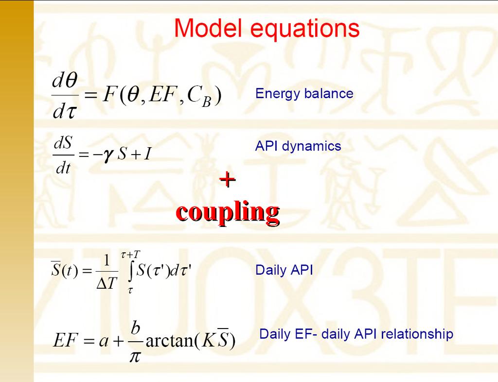
9 Dynamic approach (Castelli e al, 1999, Boni et al, 2001) The evolution of LST, as a response to the surface energy balance, is governed by the law of heat diffusion Force-restore approximation: Soil uniform thermal properties with depth Periodic temperature variations at the surface Assumptions: H= ρ c p C H U (T s -T a ) LE=H/(1-EF) (Caparrini et al, 2003, 2004) daytime EF variations negligible (Crago & Brutsaert, 1996) EF FIFE 87 dataset 9
10 Dynamic approach Advantages Continuous estimates (Castelli et al, 1999) Interpolation between sparse observations (Boni et al, 2001) No Need for a-priori estimate of surface roughness 10
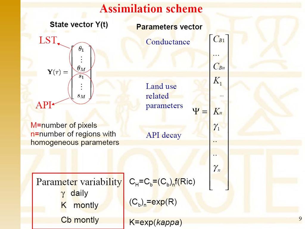
11 Data assimilation Variational data assimilation: minimizing cost function dependent on T obs -T model Goal: find EF (diurnal average) and (C H ) N that minimize RMSE of T model Bouttier & Courtier, (1999) 11
12 Details : variational scheme (Caparrini et al. 2003, 2004) Minimize J... assuming X=T s, Y=[(C H ) N, EF] and (C H ) N =C B =exp(r) 12
13 Performance of the model Both forward and backwards equation depend on C B /(1-EF) The problem tends to be ill posed: there are combinations of EF and C B that leads to almost same results in terms of Ts RMSE The physical interpretation of the retrieval is sometimes compromised Performance is good for sites with large and highly variable Ts-Ta (dry - sparsely vegetated sites) Performance can be enhanced defining a-priori bounds for EF or using TWO Source Models Crow and Kustas (2004) After Crow and Kustas (2004) 13
: -Daily EF correlated to Ts and vegetation cover -correlation dependent on near-surface soil moisture Equation simulating soil surface moisture dynamics added: Antecedent Precipitation Index")
14 Including effects of soil moisture on energy balance Kustas et al. (93): -Daily EF correlated to Ts and vegetation cover -correlation dependent on near-surface soil moisture Equation simulating soil surface moisture dynamics added: Antecedent Precipitation Index (API, indicated as S here) as nearsurface soil moisture proxy: γ I model parameter rainfall intensity Same form of the heat diffusion equation
 = S( τ ') dτ ' T τ EF = a + b arctan( K S) π a, b evaluated from FIFE experiment, K model")
15 Coupling of dynamic equations Daylight values of EF almost constant: Assimilation done in the time window 9 a.m. 4 p.m. Coupling of two dynamic eqs. done with EF-S relation Daily S value: τ + T 1 S( t) = S( τ ') dτ ' T τ EF = a + b arctan( K S) π a, b evaluated from FIFE experiment, K model parameter
16 16
17 17

 100 0 0 5 10 15 20 25 30-100 hour Hourly latent and")
18 Observation Data input Assimilated data Land surface temperature LST Micrometeorological forcing: Air Temperature T a Wind speed U Net Radiation R n Precipitation December July Estimated variables Data output LE (W/m 2 ) Daily EF = f (γ, K ) hour Hourly latent and heat fluxes = f ([C b ] N ) 19
 Ground network Precipitation fields:")
19 VALIDATION: Southern Great Plains 1997 hydrology field experiment data Field site:16000 km 2 Kansas- Oklahoma-USA Model grid: 4km*4 km Period: 18th June-18th July 1997 Forcing Data: LST Data: AVHRR resolution data: 1km*1km GOES resolution data: 50km*50km SSM/I resolution data: 25 km*25km R s : GOES derived products Micrometeorological data (ρ v, U, T a ) Ground network Precipitation fields: WSR-88D Nexrad radar precipitation estimates and raingauge reports Validation data of soil moisture and energy fluxes available!! 20


20 Precipitation input Improvement of EF and LST pattern with a better distributed precipitation field WSR-88D Nexrad radar precipitation estimates and raingauge reports National Weather Service Arkansas-Red Basin River Forecast Center Thiessen interpolation raingauges measurements 21

21 Half hour time step 6-18 local time Data in SGP domain for each time step LST from satellite platform LST by model Wind velocity Air temperature Interpolated ground data Incoming net radiation Meteo Radar precipitation field 22


22 NDVI vs. C B and K 23

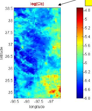
23 DEM vs C B 24

24 EL RENO - SGP97 Heat fluxes (W/m 2 ) LE (W/m 2 ) Dots : model estimates Bars : observed variability inside site pixel H (W/m 2 ) 25

25 FLUXES: the time sequences of diurnal averages in the period of analysis El reno site-sgp97 LE latent heat flux H sensible heat flux 26

- all pixels 0.")
26 SGP97 Estar soil moisture data and Evaporative fraction: pattern comparison Rescaled variables Average over the domain Julian day daily EF EF Daily values Correlation coefficient ρ Available daily data, for the same domain, inside Julian days period Daily average over the domain 0.85 All period (available days)- all pixels 0.52 % ESTAR soil moisture 27
27 DATA: Tanaro MSG, MODIS and AVHRR data LST and cloud mask products Regional micrometeorological ground net measurements Basilicata Application to mediterranean region Basilicata region (~10000 km 2 ) Summer 2004 Tanaro basin (~8500 km 2 ) Fall 2004 Model grid: 3km*3 km 28

28 C B, K vs. NDVI 29
29 ρ (NDVI and log(k) )= 0.67 ρ (NDVI and log(cb N ))=
30 Conclusions Consistent relations between parameters and land use Physical interpretation of model parameters acceptable Energy fluxes consistent with measurements Regional estimates Further development: use of meteorological analyses instead of micrometeorological ground observations for R n, T a and U 31
John R. Mecikalski #1, Martha C. Anderson*, Ryan D. Torn #, John M. Norman*, George R. Diak #
 P4.22 THE ATMOSPHERE-LAND EXCHANGE INVERSE (ALEXI) MODEL: REGIONAL- SCALE FLUX VALIDATIONS, CLIMATOLOGIES AND AVAILABLE SOIL WATER DERIVED FROM REMOTE SENSING INPUTS John R. Mecikalski #1, Martha C. Anderson*,
68 IEEE GEOSCIENCE AND REMOTE SENSING LETTERS, VOL. 12, NO. 1, JANUARY 2015
 68 IEEE GEOSCIENCE AND REMOTE SENSING LETTERS, VOL. 12, NO. 1, JANUARY 2015 Estimating Turbulent Heat Fluxes With a Weak-Constraint Data Assimilation Scheme: A Case Study (HiWATER-MUSOEXE) Tongren Xu,
METRIC tm. Mapping Evapotranspiration at high Resolution with Internalized Calibration. Shifa Dinesh
 METRIC tm Mapping Evapotranspiration at high Resolution with Internalized Calibration Shifa Dinesh Outline Introduction Background of METRIC tm Surface Energy Balance Image Processing Estimation of Energy
A methodology for estimation of surface evapotranspiration
 1 A methodology for estimation of surface evapotranspiration over large areas using remote sensing observations Le Jiang and Shafiqul Islam Cincinnati Earth Systems Science Program, Department of Civil
Mapping Evapotranspiration and Drought at Local to Continental Scales Using Thermal Remote Sensing
 Mapping Evapotranspiration and Drought at Local to Continental Scales Using Thermal Remote Sensing M.C. Anderson, W.P. Kustas USDA-ARS, Hydrology and Remote Sensing Laboratory J.M Norman University of
Surface heat flux estimation with the ensemble Kalman smoother: Joint estimation of state and parameters
 Surface heat flux estimation with the ensemble Kalman smoother: Joint estimation of state and parameters The MIT Faculty has made this article openly available. Please share how this access benefits you.
May 3, :41 AOGS - AS 9in x 6in b951-v16-ch13 LAND SURFACE ENERGY BUDGET OVER THE TIBETAN PLATEAU BASED ON SATELLITE REMOTE SENSING DATA
 Advances in Geosciences Vol. 16: Atmospheric Science (2008) Eds. Jai Ho Oh et al. c World Scientific Publishing Company LAND SURFACE ENERGY BUDGET OVER THE TIBETAN PLATEAU BASED ON SATELLITE REMOTE SENSING
A SATELLITE LAND DATA ASSIMILATION SYTEM COUPLED WITH A MESOSCALE MODEL: TOWARDS IMPROVING NUMERICAL WEATHER PREDICTION
 A SATELLITE LAND DATA ASSIMILATION SYTEM COUPLED WITH A MESOSCALE MODEL: TOWARDS IMPROVING NUMERICAL WEATHER PREDICTION Mohamed Rasmy*, Toshio Koike*, Souhail Bousseta**, Xin Li*** Dept. of Civil Engineering,
ESTIMATION OF ATMOSPHERIC COLUMN AND NEAR SURFACE WATER VAPOR CONTENT USING THE RADIANCE VALUES OF MODIS
 ESTIMATION OF ATMOSPHERIC COLUMN AND NEAR SURFACE WATER VAPOR CONTENT USIN THE RADIANCE VALUES OF MODIS M. Moradizadeh a,, M. Momeni b, M.R. Saradjian a a Remote Sensing Division, Centre of Excellence
Multi-scale Remote Assessment of Land-surface Hydrologic Response to Stress
 Multi-scale Remote Assessment of Land-surface Hydrologic Response to Stress M.C. Anderson J.M. Norman U Wisconsin-Madison W.P. Kustas USDA-ARS, HRSL T.P. Meyers NOAA-ATDD J.M. Jacobs U New Hampshire NASA
Soil Moisture Prediction and Assimilation
 Soil Moisture Prediction and Assimilation Analysis and Prediction in Agricultural Landscapes Saskatoon, June 19-20, 2007 STEPHANE BELAIR Meteorological Research Division Prediction and Assimilation Atmospheric
Monitoring daily evapotranspiration in the Alps exploiting Sentinel-2 and meteorological data
 Monitoring daily evapotranspiration in the Alps exploiting Sentinel-2 and meteorological data M. Castelli, S. Asam, A. Jacob, M. Zebisch, and C. Notarnicola Institute for Earth Observation, Eurac Research,
Research Activities at CIMA Foundation and contributions to task teams activities
 4 HyMeX Workshop Bologna, 8-10 June 2010 Research Activities at CIMA Foundation and contributions to task teams activities G. Boni(1), F. Castelli(2,1), L. Ferraris(1), S. Gabellani(1), A. Parodi(1), N.
A Facility for Producing Consistent Remotely Sensed Biophysical Data Products of Australia
 TERRESTRIAL ECOSYSTEM RESEARCH NETWORK - AusCover - A Facility for Producing Consistent Remotely Sensed Biophysical Data Products of Australia June, 2011 Mervyn Lynch Professor of Remote Sensing Curtin
Evaluation of a MODIS Triangle-based Algorithm for Improving ET Estimates in the Northern Sierra Nevada Mountain Range
 Evaluation of a MODIS Triangle-based Algorithm for Improving ET Estimates in the Northern Sierra Nevada Mountain Range Kyle R. Knipper 1, Alicia M. Kinoshita 2, and Terri S. Hogue 1 January 5 th, 2015
Evaluating Parametrizations using CEOP
 Evaluating Parametrizations using CEOP Paul Earnshaw and Sean Milton Met Office, UK Crown copyright 2005 Page 1 Overview Production and use of CEOP data Results SGP Seasonal & Diurnal cycles Other extratopical
The Two Source Energy Balance model using satellite, airborne and proximal remote sensing
 The using satellite, airborne and proximal remote sensing 7 years in a relationship Héctor Nieto Hector.nieto@irta.cat Resistance Energy Balance Models (REBM) E R e n H G Physics based on an analogy to
Evaluation of a New Land Surface Model for JMA-GSM
 Evaluation of a New Land Surface Model for JMA-GSM using CEOP EOP-3 reference site dataset Masayuki Hirai Takuya Sakashita Takayuki Matsumura (Numerical Prediction Division, Japan Meteorological Agency)
Remote sensing estimation of land surface evapotranspiration of typical river basins in China
 220 Remote Sensing for Environmental Monitoring and Change Detection (Proceedings of Symposium HS3007 at IUGG2007, Perugia, July 2007). IAHS Publ. 316, 2007. Remote sensing estimation of land surface evapotranspiration
Soil moisture analysis combining screen-level parameters and microwave brightness temperature: A test with field data
 403 Soil moisture analysis combining screen-level parameters and microwave brightness temperature: A test with field data G. Seuffert, H.Wilker 1, P. Viterbo, J.-F. Mahfouf 2, M. Drusch, J.-C. Calvet 3
Current status of lake modelling and initialisation at ECMWF
 Current status of lake modelling and initialisation at ECMWF G Balsamo, A Manrique Suñen, E Dutra, D. Mironov, P. Miranda, V Stepanenko, P Viterbo, A Nordbo, R Salgado, I Mammarella, A Beljaars, H Hersbach
Status report on the La Plata Basin (LPB) - A CLIVAR/GEWEX Continental Scale Experiment
 - A CLIVAR/GEWEX Continental Scale Experiment") Status report on the La Plata Basin (LPB) - A CLIVAR/GEWEX Continental Scale Experiment Hugo Berbery and Maria A. Silva Dias (Co-chairs for CLIVAR/VAMOS and GEWEX/GHP) with contributions of the LPB ISG
Status report on the La Plata Basin (LPB) - A CLIVAR/GEWEX Continental Scale Experiment Hugo Berbery and Maria A. Silva Dias (Co-chairs for CLIVAR/VAMOS and GEWEX/GHP) with contributions of the LPB ISG
The role of soil moisture in influencing climate and terrestrial ecosystem processes
 1of 18 The role of soil moisture in influencing climate and terrestrial ecosystem processes Vivek Arora Canadian Centre for Climate Modelling and Analysis Meteorological Service of Canada Outline 2of 18
Mapping surface fluxes using Visible - Near Infrared and Thermal Infrared data with the SEBAL Algorithm
 Mapping surface fluxes using Visible - Near Infrared and Thermal Infrared data with the SEBAL Algorithm F. Jacob 1, A. Olioso 1, X.F. Gu 1, J.F. Hanocq 1, O. Hautecoeur 2, and M. Leroy 2 1 INRA bioclimatologie,
Atmospheric Processes
 Atmospheric Processes Atmospheric prognostic variables Wind Temperature Humidity Cloud Water/Ice Atmospheric processes Mixing Radiation Condensation/ Evaporation Precipitation Surface exchanges Friction
Evapotranspiration. Andy Black. CCRN Processes Workshop, Hamilton, ON, Sept Importance of evapotranspiration (E)
") Evapotranspiration Andy Black CCRN Processes Workshop, Hamilton, ON, 12-13 Sept 213 Importance of evapotranspiration (E) This process is important in CCRN goals because 1. Major component of both terrestrial
Evapotranspiration Andy Black CCRN Processes Workshop, Hamilton, ON, 12-13 Sept 213 Importance of evapotranspiration (E) This process is important in CCRN goals because 1. Major component of both terrestrial
Development of the Canadian Precipitation Analysis (CaPA) and the Canadian Land Data Assimilation System (CaLDAS)
 and the Canadian Land Data Assimilation System (CaLDAS)") Development of the Canadian Precipitation Analysis (CaPA) and the Canadian Land Data Assimilation System (CaLDAS) Marco L. Carrera, Vincent Fortin and Stéphane Bélair Meteorological Research Division Environment
Development of the Canadian Precipitation Analysis (CaPA) and the Canadian Land Data Assimilation System (CaLDAS) Marco L. Carrera, Vincent Fortin and Stéphane Bélair Meteorological Research Division Environment
2009 Progress Report To The National Aeronautics and Space Administration NASA Energy and Water Cycle Study (NEWS) Program
 Program") 2009 Progress Report To The National Aeronautics and Space Administration NASA Energy and Water Cycle Study (NEWS) Program Proposal Title: Grant Number: PI: The Challenges of Utilizing Satellite Precipitation
2009 Progress Report To The National Aeronautics and Space Administration NASA Energy and Water Cycle Study (NEWS) Program Proposal Title: Grant Number: PI: The Challenges of Utilizing Satellite Precipitation
Joint International Surface Working Group and Satellite Applications Facility on Land Surface Analysis Workshop, IPMA, Lisboa, June 2018
 Joint International Surface Working Group and Satellite Applications Facility on Land Surface Analysis Workshop, IPMA, Lisboa, 26-28 June 2018 Introduction Soil moisture Evapotranspiration Future plan
Evapotranspiration monitoring with Meteosat Second Generation satellites: method, products and utility in drought detection.
 Evapotranspiration monitoring with Meteosat Second Generation satellites: method, products and utility in drought detection. Nicolas Ghilain Royal Meteorological Institute Belgium EUMeTrain Event week
1. Current atmospheric DA systems 2. Coupling surface/atmospheric DA 3. Trends & ideas
 1 Current issues in atmospheric data assimilation and its relationship with surfaces François Bouttier GAME/CNRM Météo-France 2nd workshop on remote sensing and modeling of surface properties, Toulouse,
Land Data Assimilation at NCEP NLDAS Project Overview, ECMWF HEPEX 2004
 Dag.Lohmann@noaa.gov, Land Data Assimilation at NCEP NLDAS Project Overview, ECMWF HEPEX 2004 Land Data Assimilation at NCEP: Strategic Lessons Learned from the North American Land Data Assimilation System
Evaluation of SEBAL Model for Evapotranspiration Mapping in Iraq Using Remote Sensing and GIS
 Evaluation of SEBAL Model for Evapotranspiration Mapping in Iraq Using Remote Sensing and GIS Hussein Sabah Jaber* Department of Civil Engineering, University Putra Malaysia, 43400 UPM Serdang, Selangor,
Flux Tower Data Quality Analysis. Dea Doklestic
 Flux Tower Data Quality Analysis Dea Doklestic Motivation North American Monsoon (NAM) Seasonal large scale reversal of atmospheric circulation Occurs during the summer months due to a large temperature
Land Surface Processes and Their Impact in Weather Forecasting
 Land Surface Processes and Their Impact in Weather Forecasting Andrea Hahmann NCAR/RAL with thanks to P. Dirmeyer (COLA) and R. Koster (NASA/GSFC) Forecasters Conference Summer 2005 Andrea Hahmann ATEC
Near Real-time Evapotranspiration Estimation Using Remote Sensing Data
 Near Real-time Evapotranspiration Estimation Using Remote Sensing Data by Qiuhong Tang 08 Aug 2007 Land surface hydrology group of UW Land Surface Hydrology Research Group ❶ ❷ ❸ ❹ Outline Introduction
Assimilating terrestrial remote sensing data into carbon models: Some issues
 University of Oklahoma Oct. 22-24, 2007 Assimilating terrestrial remote sensing data into carbon models: Some issues Shunlin Liang Department of Geography University of Maryland at College Park, USA Sliang@geog.umd.edu,
Assimilation of Snow and Ice Data (Incomplete list)
") Assimilation of Snow and Ice Data (Incomplete list) Snow/ice Sea ice motion (sat): experimental, climate model Sea ice extent (sat): operational, U.S. Navy PIPs model; Canada; others? Sea ice concentration
Assimilation of Snow and Ice Data (Incomplete list) Snow/ice Sea ice motion (sat): experimental, climate model Sea ice extent (sat): operational, U.S. Navy PIPs model; Canada; others? Sea ice concentration
USE OF SATELLITE REMOTE SENSING IN HYDROLOGICAL PREDICTIONS IN UNGAGED BASINS
 USE OF SATELLITE REMOTE SENSING IN HYDROLOGICAL PREDICTIONS IN UNGAGED BASINS Venkat Lakshmi, PhD, P.E. Department of Geological Sciences, University of South Carolina, Columbia SC 29208 (803)-777-3552;
METEOSAT SECOND GENERATION DATA FOR ASSESSMENT OF SURFACE MOISTURE STATUS
 METEOSAT SECOND GENERATION DATA FOR ASSESSMENT OF SURFACE MOISTURE STATUS Simon Stisen (1), Inge Sandholt (1), Rasmus Fensholt (1) (1) Institute of Geography, University of Copenhagen, Oestervoldgade 10,
4.4 EVALUATION OF AN IMPROVED CONVECTION TRIGGERING MECHANISM IN THE NCAR COMMUNITY ATMOSPHERE MODEL CAM2 UNDER CAPT FRAMEWORK
 . EVALUATION OF AN IMPROVED CONVECTION TRIGGERING MECHANISM IN THE NCAR COMMUNITY ATMOSPHERE MODEL CAM UNDER CAPT FRAMEWORK Shaocheng Xie, James S. Boyle, Richard T. Cederwall, and Gerald L. Potter Atmospheric
Remote sensing estimates of actual evapotranspiration in an irrigation district
 Engineers Australia 29th Hydrology and Water Resources Symposium 21 23 February 2005, Canberra Remote sensing estimates of actual evapotranspiration in an irrigation district Cressida L. Department of
ECMWF soil moisture data assimilation
 ECMWF soil moisture data assimilation Janneke Ettema and Pedro Viterbo ECMWF, Shinfield Park, Reading RG2 9AX, United Kingdom J.Ettema@ECMWF.int, P.Viterbo@ECMWF.int 1. Introduction Soil moisture is a
Assessing spatial variability of soil water content through Thermal Inertia and NDVI
 Assessing spatial variability of soil water content through Thermal Inertia and NDVI Pierluigi Claps a, Giovanni Laguardia b a DITIC, Polytechnic of Turin, Turin, Italy b DIFA-CIMA, University of Basilicata,
The Canadian Land Data Assimilation System (CaLDAS)
") The Canadian Land Data Assimilation System (CaLDAS) Marco L. Carrera, Stéphane Bélair, Bernard Bilodeau and Sheena Solomon Meteorological Research Division, Environment Canada Dorval, QC, Canada 2 nd Workshop
The Canadian Land Data Assimilation System (CaLDAS) Marco L. Carrera, Stéphane Bélair, Bernard Bilodeau and Sheena Solomon Meteorological Research Division, Environment Canada Dorval, QC, Canada 2 nd Workshop
EUMETSAT LSA-SAF EVAPOTRANSPIRATION PRODUCTS STATUS AND PERSPECTIVES
 EUMETSAT LSA-SAF EVAPOTRANSPIRATION PRODUCTS STATUS AND PERSPECTIVES Arboleda, N. Ghilain, F. Gellens-Meulenberghs Royal Meteorological Institute, Avenue Circulaire, 3, B-1180 Bruxelles, BELGIUM Corresponding
Drought Monitoring with Hydrological Modelling
 st Joint EARS/JRC International Drought Workshop, Ljubljana,.-5. September 009 Drought Monitoring with Hydrological Modelling Stefan Niemeyer IES - Institute for Environment and Sustainability Ispra -
Improved Fields of Satellite-Derived Ocean Surface Turbulent Fluxes of Energy and Moisture
 Improved Fields of Satellite-Derived Ocean Surface Turbulent Fluxes of Energy and Moisture First year report on NASA grant NNX09AJ49G PI: Mark A. Bourassa Co-Is: Carol Anne Clayson, Shawn Smith, and Gary
EUMETSAT SAF NETWORK. Lothar Schüller, EUMETSAT SAF Network Manager
 1 EUMETSAT SAF NETWORK Lothar Schüller, EUMETSAT SAF Network Manager EUMETSAT ground segment overview METEOSAT JASON-2 INITIAL JOINT POLAR SYSTEM METOP NOAA SATELLITES CONTROL AND DATA ACQUISITION FLIGHT
Climate Impacts of Agriculture Related Land Use Change in the US
 Climate Impacts of Agriculture Related Land Use Change in the US Jimmy Adegoke 1, Roger Pielke Sr. 2, Andrew M. Carleton 3 1 Dept. Of Geosciences, University of Missouri-Kansas City 2 Dept. of Atmospheric
SOIL MOISTURE MAPPING THE SOUTHERN U.S. WITH THE TRMM MICROWAVE IMAGER: PATHFINDER STUDY
 SOIL MOISTURE MAPPING THE SOUTHERN U.S. WITH THE TRMM MICROWAVE IMAGER: PATHFINDER STUDY Thomas J. Jackson * USDA Agricultural Research Service, Beltsville, Maryland Rajat Bindlish SSAI, Lanham, Maryland
4.5 Comparison of weather data from the Remote Automated Weather Station network and the North American Regional Reanalysis
 4.5 Comparison of weather data from the Remote Automated Weather Station network and the North American Regional Reanalysis Beth L. Hall and Timothy. J. Brown DRI, Reno, NV ABSTRACT. The North American
Remote Sensing Applications for Land/Atmosphere: Earth Radiation Balance
 Remote Sensing Applications for Land/Atmosphere: Earth Radiation Balance - Introduction - Deriving surface energy balance fluxes from net radiation measurements - Estimation of surface net radiation from
SUPPORTING INFORMATION. Ecological restoration and its effects on the
 SUPPORTING INFORMATION Ecological restoration and its effects on the regional climate: the case in the source region of the Yellow River, China Zhouyuan Li, Xuehua Liu,* Tianlin Niu, De Kejia, Qingping
Surface issues for High Resolution NWP
 Surface issues for High Resolution NWP François Bouyssel - Jean-François Mahfouf with many contributors High Resolution NWP Workshop, 17-20 May 2010, Brac, Croatia Outline Introduction (specificities of
Assimilation of satellite fapar data within the ORCHIDEE biosphere model and its impacts on land surface carbon and energy fluxes
 Laboratoire des Sciences du Climat et de l'environnement Assimilation of satellite fapar data within the ORCHIDEE biosphere model and its impacts on land surface carbon and energy fluxes CAMELIA project
Length Scale Analysis of Surface Energy Fluxes Derived from Remote Sensing
 1212 JOURNAL OF HYDROMETEOROLOGY VOLUME 4 Length Scale Analysis of Surface Energy Fluxes Derived from Remote Sensing NATHANIEL A. BRUNSELL* Department of Plants, Soils, and Biometeorology, Utah State University,
Arctic System Reanalysis *
 Arctic System Reanalysis * David H. Bromwich 1,2, Keith M. Hines 1 and Le-Sheng Bai 1 1 Polar Meteorology Group, Byrd Polar Research Center 2 Atmospheric Sciences Program, Dept. of Geography The Ohio State
Influence of variations in low-level moisture and soil moisture on the organization of summer convective systems in the US Midwest
 Influence of variations in low-level moisture and soil moisture on the organization of summer convective systems in the US Midwest Jimmy O. Adegoke 1, Sajith Vezhapparambu 1, Christopher L. Castro 2, Roger
STUDIES ON MODEL PREDICTABILITY IN VARIOUS CLIMATIC CONDITIONS: AN EFFORT USING CEOP EOP1 DATASET
 STUDIES ON MODEL PREDICTABILITY IN VARIOUS CLIMATIC CONDITIONS: AN EFFORT USING CEOP EOP DATASET KUN YANG, KATSUNORI TAMAGAWA, PETRA KOUDELOVA, TOSHIO KOIKE Department of Civil Engineering, University
The National Operational Hydrologic Remote Sensing Center Operational Snow Analysis
 The National Operational Hydrologic Remote Sensing Center Operational Snow Analysis World Meteorological Organization Global Cryosphere Watch Snow-Watch Workshop Session 3: Snow Analysis Products Andrew
The Ocean-Atmosphere System II: Oceanic Heat Budget
 The Ocean-Atmosphere System II: Oceanic Heat Budget C. Chen General Physical Oceanography MAR 555 School for Marine Sciences and Technology Umass-Dartmouth MAR 555 Lecture 2: The Oceanic Heat Budget Q
Soil moisture retrieval with remote sensing images for debris flow forecast in humid regions
 Monitoring, Simulation, Prevention and Remediation of Dense and Debris Flows III 89 Soil moisture retrieval with remote sensing images for debris flow forecast in humid regions Y. Zhao 1,2,3, H. Yang 1,2
European Drought Observatory Progress on Drought Monitoring
 European Drought Observatory Progress on Drought Monitoring Alfred de Jager Diego Magni European Commission Joint Research Centre (JRC) Disaster Risk Management Unit Outline 1. Introduction Philosophy
Assimilation of ASCAT soil wetness
 EWGLAM, October 2010 Assimilation of ASCAT soil wetness Bruce Macpherson, on behalf of Imtiaz Dharssi, Keir Bovis and Clive Jones Contents This presentation covers the following areas ASCAT soil wetness
NCEP non-hydrostatic regional model and surface scheme LAPS: A dynamical scaling tool for use in agricultural models
 NCEP non-hydrostatic regional model and surface scheme LAPS: A dynamical scaling tool for use in agricultural models D.T. Mihailović and B. Lalić Faculty of Agriculture, University of Novi Sad, Novi Sad,
Predicting ectotherm disease vector spread. - Benefits from multi-disciplinary approaches and directions forward
 Predicting ectotherm disease vector spread - Benefits from multi-disciplinary approaches and directions forward Naturwissenschaften Stephanie Margarete THOMAS, Carl BEIERKUHNLEIN, Department of Biogeography,
Remote sensing derived evapotranspiration: comparisons to observations and models and results over the full MSG disk and selected basins
 4 th LSA-SAF WORKSHOP Toulouse,France, 15 th to 17 th November 2010 Remote sensing derived evapotranspiration: comparisons to observations and models and results over the full MSG disk and selected basins
Introduction to Data Assimilation
 Introduction to Data Assimilation Alan O Neill Data Assimilation Research Centre University of Reading What is data assimilation? Data assimilation is the technique whereby observational data are combined
Evaluation of remotely sensed and modelled soil moisture products using global ground-based in situ observations
 Evaluation of remotely sensed and modelled soil moisture products using global ground-based in situ observations C. Albergel (1), P. de Rosnay (1), G. Balsamo (1),J. Muñoz-Sabater(1 ), C. Gruhier (2),
Use of satellite soil moisture information for NowcastingShort Range NWP forecasts
 Use of satellite soil moisture information for NowcastingShort Range NWP forecasts Francesca Marcucci1, Valerio Cardinali/Paride Ferrante1,2, Lucio Torrisi1 1 COMET, Italian AirForce Operational Center
INTERCOMPARISON OF METEOSAT-8 DERIVED LST WITH MODIS AND AATSR SIMILAR PRODUCTS
 INTERCOMPARISON OF METEOSAT-8 DERIVED LST WITH MODIS AND AATSR SIMILAR PRODUCTS Cristina Madeira, Prasanjit Dash, Folke Olesen, and Isabel Trigo, Instituto de Meteorologia, Rua C- Aeroporto, 700-09 Lisboa,
ACCURATE estimation of energy and momentum fluxes,
 IEEE GEOSCIENCE AND REMOTE SENSING LETTERS, VOL. 4, NO. 4, OCTOBER 2007 649 A Weak-Constraint-Based Data Assimilation Scheme for Estimating Surface Turulent Fluxes Jun Qin, Shunlin Liang, Senior Memer,
Report. Northern Africa. RAIDEG-8, 1-2 Nov 2017
 Report Northern Africa RAIDEG-8, 1-2 Nov 2017 Report Northern Africa RAIDEG-8, 1-2 Nov 2017 Important Note: Formal letters have been sent from the PR of Morocco with WMO to PRs of Algeria, Tunisia, Libya
P r o c e. d i n g s. 1st Workshop. Madrid, Spain September 2002
 P r o c e e d i n g s 1st Workshop Madrid, Spain 23-27 September 2002 IMPACTS OF IMPROVED ERROR ANALYSIS ON THE ASSIMILATION OF POLAR SATELLITE PASSIVE MICROWAVE PRECIPITATION ESTIMATES INTO THE NCEP GLOBAL
Estimation of Wavelet Based Spatially Enhanced Evapotranspiration Using Energy Balance Approach
 Estimation of Wavelet Based Spatially Enhanced Evapotranspiration Using Energy Balance Approach Dr.Gowri 1 Dr.Thirumalaivasan 2 1 Associate Professor, Jerusalem College of Engineering, Department of Civil
Near-surface weather prediction and surface data assimilation: challenges, development, and potential data needs
 Near-surface weather prediction and surface data assimilation: challenges, development, and potential data needs Zhaoxia Pu Department of Atmospheric Sciences University of Utah, Salt Lake City, Utah,
Georgy V. Mostovoy*¹, Valentine Anantharaj¹, Paul R. Houser², and Christa D. Peters-Lidard³
 P2.3 USE OF SCAN OBSERVATIONS FOR VALIDATION OF SOIL MOISTURE SPATIAL DISTRIBUTION SIMULATED BY THE LAND-SURFACE MODEL OVER THE LOWER MISSISSIPPI DELTA REGION Georgy V. Mostovoy*¹, Valentine Anantharaj¹,
Satellite-based Lake Surface Temperature (LST) Homa Kheyrollah Pour Claude Duguay
 Homa Kheyrollah Pour Claude Duguay") Satellite-based Lake Surface Temperature (LST) Homa Kheyrollah Pour Claude Duguay Lakes in NWP models Interaction of the atmosphere and underlying layer is the most important issue in climate modeling
Satellite-based Lake Surface Temperature (LST) Homa Kheyrollah Pour Claude Duguay Lakes in NWP models Interaction of the atmosphere and underlying layer is the most important issue in climate modeling
Creating a WeatherSMART nation: SAWS drought related research, services and products
 Creating a WeatherSMART nation: SAWS drought related research, services and products Drought Dialogue 23-24 June 2016 Western Cape Government Hannes Rautenbach South African Weather Service SAWS mandate
Climate Variables for Energy: WP2
 Climate Variables for Energy: WP2 Phil Jones CRU, UEA, Norwich, UK Within ECEM, WP2 provides climate data for numerous variables to feed into WP3, where ESCIIs will be used to produce energy-relevant series
NIDIS Intermountain West Drought Early Warning System August 8, 2017
 NIDIS Drought and Water Assessment 8/8/17, 4:43 PM NIDIS Intermountain West Drought Early Warning System August 8, 2017 Precipitation The images above use daily precipitation statistics from NWS COOP,
Assimilation of satellite derived soil moisture for weather forecasting
 Assimilation of satellite derived soil moisture for weather forecasting www.cawcr.gov.au Imtiaz Dharssi and Peter Steinle February 2011 SMOS/SMAP workshop, Monash University Summary In preparation of the
Assimilation of precipitation-related observations into global NWP models
 Assimilation of precipitation-related observations into global NWP models Alan Geer, Katrin Lonitz, Philippe Lopez, Fabrizio Baordo, Niels Bormann, Peter Lean, Stephen English Slide 1 H-SAF workshop 4
Eric. W. Harmsen 1, John Mecikalski 2, Pedro Tosado Cruz 1 Ariel Mercado Vargas 1
 Estimating Evapotranspiration using Satellite Remote Sensing in Puerto Rico, Haiti and the Dominican Republic Eric. W. Harmsen 1, John Mecikalski 2, Pedro Tosado Cruz 1 Ariel Mercado Vargas 1 1. University
Weather Forecasting. March 26, 2009
 Weather Forecasting Chapter 13 March 26, 2009 Forecasting The process of inferring weather from a blend of data, understanding, climatology, and solutions of the governing equations Requires an analysis
Incorporation of SMOS Soil Moisture Data on Gridded Flash Flood Guidance for Arkansas Red River Basin
 Incorporation of SMOS Soil Moisture Data on Gridded Flash Flood Guidance for Arkansas Red River Basin Department of Civil and Environmental Engineering, The City College of New York, NOAA CREST Dugwon
GCOM-W1 now on the A-Train
 GCOM-W1 now on the A-Train GCOM-W1 Global Change Observation Mission-Water Taikan Oki, K. Imaoka, and M. Kachi JAXA/EORC (& IIS/The University of Tokyo) Mini-Workshop on A-Train Science, March 8 th, 2013
Regional offline land surface simulations over eastern Canada using CLASS. Diana Verseghy Climate Research Division Environment Canada
 Regional offline land surface simulations over eastern Canada using CLASS Diana Verseghy Climate Research Division Environment Canada The Canadian Land Surface Scheme (CLASS) Originally developed for the
Land Surface Temperature in the EUMETSAT LSA SAF: Current Service and Perspectives. Isabel Trigo
 Land Surface Temperature in the EUMETSAT LSA SAF: Current Service and Perspectives Isabel Trigo Outline EUMETSAT Land-SAF: Land Surface Temperature Geostationary Service SEVIRI Polar-Orbiter AVHRR/Metop
P1.34 MULTISEASONALVALIDATION OF GOES-BASED INSOLATION ESTIMATES. Jason A. Otkin*, Martha C. Anderson*, and John R. Mecikalski #
 P1.34 MULTISEASONALVALIDATION OF GOES-BASED INSOLATION ESTIMATES Jason A. Otkin*, Martha C. Anderson*, and John R. Mecikalski # *Cooperative Institute for Meteorological Satellite Studies, University of
METR 130: Lecture 2 - Surface Energy Balance - Surface Moisture Balance. Spring Semester 2011 February 8, 10 & 14, 2011
 METR 130: Lecture 2 - Surface Energy Balance - Surface Moisture Balance Spring Semester 2011 February 8, 10 & 14, 2011 Reading Arya, Chapters 2 through 4 Surface Energy Fluxes (Ch2) Radiative Fluxes (Ch3)
Inter- Annual Land Surface Variation NAGS 9329
 Annual Report on NASA Grant 1 Inter- Annual Land Surface Variation NAGS 9329 PI Stephen D. Prince Co-I Yongkang Xue April 2001 Introduction This first period of operations has concentrated on establishing
On the usage of screen-level parameters and microwave brightness temperature for soil moisture analysis
 421 On the usage of screen-level parameters and microwave brightness temperature for soil moisture analysis G. Seuffert, H.Wilker 1, P. Viterbo, M.Drusch, J.-F. Mahfouf 2 Research Department 1 MIUB, Germany,
Flux Tower Data Quality Analysis in the North American Monsoon Region
 Flux Tower Data Quality Analysis in the North American Monsoon Region 1. Motivation The area of focus in this study is mainly Arizona, due to data richness and availability. Monsoon rains in Arizona usually
Water Balance in the Murray-Darling Basin and the recent drought as modelled with WRF
 18 th World IMACS / MODSIM Congress, Cairns, Australia 13-17 July 2009 http://mssanz.org.au/modsim09 Water Balance in the Murray-Darling Basin and the recent drought as modelled with WRF Evans, J.P. Climate
Remote Sensing of Precipitation
 Lecture Notes Prepared by Prof. J. Francis Spring 2003 Remote Sensing of Precipitation Primary reference: Chapter 9 of KVH I. Motivation -- why do we need to measure precipitation with remote sensing instruments?
Quantitative Flood Forecasts using Short-term Radar Nowcasting
 Quantitative Flood Forecasts using Short-term Radar Nowcasting Enrique R. Vivoni *, Dara Entekhabi *, Rafael L. Bras *, Matthew P. Van Horne *, Valeri Y. Ivanov *, Chris Grassotti + and Ross Hoffman +
The Heat Budget for Mt. Hope Bay
 The School for Marine Science and Technology The Heat Budget for Mt. Hope Bay Y. Fan and W. Brown SMAST, UMassD SMAST Technical Report No. SMAST-03-0801 The School for Marine Science and Technology University
Representing inland water bodies and coastal areas in global numerical weather prediction
 Representing inland water bodies and coastal areas in global numerical weather prediction Gianpaolo Balsamo, Anton Beljaars, Souhail Boussetta, Emanuel Dutra Outline: Introduction lake and land contrasts