National Aeronautics and Space Administration SPHERES OF EARTH. An Introduction to Making Observations of Earth Using an Earth System Science Approach
|
|
|
- Marianna Sanders
- 5 years ago
- Views:
Transcription


1 An Introduction to Making Observations of Earth Using an Earth System Science Approach
 Directorate ARES Education Program, JACOBS Engineering Science Contract Group (ESCG) Edited by the following educators and scientists")
2 An Introduction to Making Observations of Earth Using an Earth System Science Approach Written and Developed by: Paige Valderrama Graff Science Education Specialist, Expedition Earth and Beyond Director Astromaterials Research and Exploration Science (ARES) Directorate ARES Education Program, JACOBS Engineering Science Contract Group (ESCG) Edited by the following educators and scientists within the Astromaterials Research and Exploration Science (ARES) Directorate at the : Marshalyn Baker, Classroom Teacher Trevor Graff, Planetary Scientist Charlie Lindgren, Classroom Teacher Michele Mailhot, Classroom Teacher Tim McCollum, Classroom Teacher Susan Runco, Physical Scientist William Stefanov, Senior Geoscientist Kim Willis, Principal Geoscientist Front cover images courtesy of the ARES Image Science and Analysis Laboratory, NASA JSC Astromaterials Research and Exploration Science (ARES) Education Program. All rights reserved. This document may be freely distributed for non commercial use only.
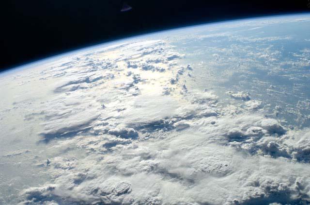
3 Part 1: Systems and Features Earth is a diverse planet. What makes up our planet and how does it work? Earth System Science is one way to think about the different parts or systems that make up Earth as a whole. In the first part of this activity you will think about Earth systems and the different features that can be associated with those systems. To help you get started, let s first look at an example using the human body. Understanding Systems: Using the Human Body as an example The human body is made up of a set of systems that work together to help our bodies function properly. Each system has a specific function and has various parts/features. The table below lists a few example body systems, a key word or phrase we can associate with each system, and a few parts of the body that make up that system (system features). SYSTEM KEY WORD(S) SYSTEM FEATURES Circulatory Blood movement 1) Blood 2) Veins 3) Arteries Skeletal Bone structure 1)Tibia 2) Femur 3) Radius Respiratory Breathing 1) Lungs 2) Trachea 3) Alveoli Our bodies need each and every one of its systems. Doctors often specialize in one body system, but need to understand how the body works as a whole. Earth functions in the same way. All Earth systems are linked and each one is necessary to keep our Earth in balance. The Earth Systems are sometime called the spheres of Earth. Using the example above, think about what you may know about Earth systems and fill in the table below. Use the word bank to help you. SYSTEM KEY WORD SYSTEM FEATURES (list 3 features) Atmosphere 1) Dust storms 2) 3) Land 1) Mountains 2) Volcanoes 3) Hydrosphere 1) Lakes 2) 3) Life 1) Plankton 2) Coral Reefs 3) Word bank: Glaciers Hurricanes Water Clouds Oceans Forests Biosphere Impact Craters Air Litho/Geosphere As you continue with this activity you will learn more about each system. You will also observe many different features in stunning images of Earth taken by astronauts. As you observe each image, take note that features from multiple spheres are almost always visible. Let s learn more! 1
 work with astronauts onboard the International Space Station (ISS) who take images of Earth.")
4 Part 2: Background Information & Data Collection Background Information CREW EARTH OBSERVATIONS (CEO) Scientists from the Image Science and Analysis Laboratory (ISAL) at NASA s Johnson Space Center (JSC) work with astronauts onboard the International Space Station (ISS) who take images of Earth. Astronaut photographs, sometimes referred to as Crew Earth Observations, are taken using hand held digital cameras onboard the ISS. These digital images allow scientists to study Earth from the unique perspective of space. Astronauts have taken images of Earth since the 1960s. There is a database of over 900,000 astronaut photographs available at The Gateway to Astronaut Photography of Earth website ( Images are requested by ISAL scientists at JSC and astronauts in space personally frame and acquire them from the Destiny Laboratory window or other windows in the ISS. By having astronauts take images, they can specifically frame them according to a given request and need. For example, they can choose to use different lenses to vary the amount of area or detail an image will include. Images can be taken at different times of the day. This allows different lighting conditions to bring out or highlight certain features. The viewing angle at which an image is taken can also be varied to show the same area from different perspectives. Nadir views are when an image is taken with the camera pointing straight down. Oblique views are when an image is taken with the camera pointed at an angle. Being able to change these variables makes astronaut photographs a unique and useful data set. Astronaut photographs are taken from the ISS from altitudes of km (~185 to 250 miles). One of the current cameras being used, the Nikon D3X digital camera, can take images using a 50, 80, 180, 250, 400, or 800mm lens. These different lenses allow for a wider or narrower area to be included in an image. Generally, the higher the camera focal length (400mm for example) the smaller area imaged. Higher focal lengths also show greater detail of the features in an image. The image shown here illustrates what an astronaut would see looking out the Destiny window from the ISS. You can see the circular outline of the window as well as the amount of surface area that would be imaged with different lenses. Outline of Destiny window Green boxes indicate the approximate area covered in images taken with different lenses. Image source: Windows on Earth website: 2


5 EARTH SYSTEM SCIENCE Our diverse planet Earth has so many different features that can be studied from space. One approach to studying Earth is by taking an Earth Systems Science approach. As you may remember from Part 1 of the activity, Earth Systems Science involves looking at Earth as a set of systems. These systems are all connected and influence one another as well as the Earth as a whole. Each individual system consists of features that together play a role in keeping our Earth in balance. A change within one system will cause a change in another. The past, present, and future of our planet is based on the constant interaction among these systems. Let s take a closer look at each individual Earth system or sphere, and associated features you can observe in astronaut photographs: 1. Atmosphere: This sphere relates to meteorological features and phenomena such as weather, clouds, or aerosols (particles in the air). It includes an ever changing mixture of gas and small particles located above and surrounding the Earth s surface. Features include: Clouds Hurricanes and Cyclones Aurora Air Pollution/Aerosols Dust and Sand Storms 2. Biosphere: This sphere is associated with living systems such as biomes or ecosystems. This includes life on land, in the oceans and rivers, and even life we cannot see with the naked eye. Features we can observe in astronaut photographs include: Coastal Biomes Forests Deserts Grasslands Urban/Agricultural Ecosystems 3. Hydrosphere: This sphere is associated with water in solid (ice) and liquid states. Water in a gas state (water vapor) is probably best considered as a feature of the atmosphere. Features include: Oceans Lakes and Rivers Snow Ice Bergs Glaciers 4. Litho/Geosphere: This sphere is associated with solid portions of the Earth. It includes rocks, sediments and soils, surface landforms and the processes that shape the surface. Features associated with this sphere can be broken down into a variety of different processes and related surface landforms. These are: Fluvial & Alluvial Processes: Valley networks, river channels/canyons, deltas, alluvial fans Aeolian Processes: Sand dunes, yardangs, wind streaks Tectonic Processes: Folds, faults, mountains Volcanic Processes: Volcanoes, central vents, volcanic deposits Impact Processes: Impact craters Other Processes: Mass wasting processes, erosional processes 3


6 EARTH SYSTEM CONNECTIONS As scientists focus on features within one Earth system, they must consider the influences from other systems. Influences and visible effects can sometimes be obvious and other times may go almost unnoticed. There may be some effects that are immediate, and others that may not be realized for years. Let s take the oil spill off the coast of Louisiana as an example. There were definite effects on the hydrosphere (ocean) from the spill. You could immediately see the oil in the Gulf in images taken from space. But did this spill potentially affect other spheres? Unfortunately, it did. First, think of the gases and smoke that went into the atmosphere when the explosion occurred. The biosphere (marine life and coastal ecosystems) were certainly harmed by the spill as well. As the oil reached land, it became mixed in and absorbed into the soils and sediment along the coast. These effects cannot all be observed in a single image. Scientists studying the effects on different Earth systems would also likely look at a variety of different data sets, depending on their research, in addition to images. As you make observations of images, think about how a change in one feature/system may play a role in changing another. Keep in mind that that changes can be caused from naturally occurring events like hurricanes, volcanic eruptions, or earthquakes, or from human influences. The images below are astronaut photographs. As you make observations of these images and others, you will almost always see features representing different systems. Think about the features, the system they are related to, and how a change in one system may affect features in another. The next part of this activity will let you to explore and discover more astronaut images from space! This image shows a variety of features. It includes glaciers (hydrosphere), a lake (hydrosphere), mountains (litho/geosphere) and snow or ice (hydrosphere). If there is more snow (hydrosphere) Grieve Glacer will grow and eventually flow into Lake Greve. The glaciers may also carve deeper valleys into the mountains (litho/geosphere). As Greve Glacier breaks off and melts, this will cause the Greve Lake levels to rise (hydrosphere). Image ID#: ISS003 E 6061 This image contains features such as an island/atoll (litho/geosphere), coral reefs (biosphere), sand deposits (litho/geosphere), the ocean (hydrosphere), clouds (atmosphere), and vegetation (biosphere). If sea levels were to rise (hydrosphere) this could change the coastline (litho/geosphere) of this island. Sand deposits (litho/geosphere) would possibly end up under water and vegetation and any life forms (biosphere) that lived off that vegetation would not be able to survive. Image ID#: ISS018 E


7 Part 2: Background Information & Data Collection Discovering and Exploring Features on Earth Visible from Space Now that you know a little bit about Earth systems and features, let s have you discover and explore features on Earth that are visible from space in astronaut photographs. Directions: 1. Go to the Gateway to Astronaut Photography of Earth website: 2. You will see 4 search tabs at the top of the page: Find Photos, Collections, Information, Where is your ISS? Look under the Find Photos tab and select Weekly Top For each of the Weekly Top 10 images there is a thumbnail of the image that shows you a small snapshot of the picture. To the right of each thumbnail, information is provided about the image. The important information to note is the image identification number and the brief description of features or the geographic location of the image. Click on the Image Identification number to view the image and additional metadata (details about that image). Image ID# 5
8 4. Once you click on the Image ID#, a new page will open showing the astronaut photograph along with all the metadata, which are important details about the image. It is important to be able to sort through the metadata to find important information that will be useful for you to log. Scroll down the webpage to locate the following metadata you would most commonly want to log. a. Image Identification number: This in a unique identifier for any given image. This number should appear at the top of the image you are viewing. b. Country or Geographic Name: It is interesting to learn where certain features are found on Earth. Learning about the geography of Earth is also useful! c. Features: Be aware that the features list provided on the website may not include all features visible in the image. You can revise and/or add information on your log sheet. d. Center Point Latitude and Longitude: This will allow you to locate this image on a map of Earth. Be sure to log the center latitude and longitude of the image and not the nadir point (location point straight down) from the spacecraft. e. Camera Used: Current images are often taken with the Nikon D2 and D3 camera series, but other cameras (Hasselblad, Kodak DSC760, etc.) have been previously used. f. Camera Focal Length: The focal length gives you an idea of the field of view or if a wide or narrow area is covered in the image. The higher the focal length, the narrower (smaller) the area. g. Date Acquired: It is useful to know when an image was taken so you can perhaps look at images taken of that same area on a different date and make comparisons. h. Caption: If a caption is written, it can provide you with background information about the image or geographic area. You are encouraged to read it and pull out important information to help you understand what you are observing in an image. 5. It is also extremely important to log your own observations of each image. Information to include is as follows: a. Features Observed in the image along with their associated sphere or Earth system: This will help you start to differentiate between Earth s systems and features associated with those systems. You can certainly use features already listed from the website, but you are encouraged to list features you can identify. b. Miscellaneous Observations: This allows you to list general statements, questions, observations, or sketches of the image you are observing. Now you are ready to collect data! 6
9 Part 2: Background Information & Data Collection Use the Data Collection sheet below to log data and observations of at least 4 images. To view images do the following: 1) Go to 2) Go to the Find Photos tab and select Weekly Top 10 and choose an image to observe. Astronaut Photography Image Metadata and Observations Image ID#: Latitude (N): Longitude (E): Camera Used: Date Acquired: Lens Focal Length: Country/Geographic Region: Background information about image: List 3 Visible Features, Associated Earth System, and Observations Miscellaneous Observations, Sketch, or Questions Earth Earth Earth 7
10 Part 2: Background Information & Data Collection Use the Data Collection sheet below to log data and observations of at least 4 images. To view images do the following: 1) Go to 2) Go to the Find Photos tab and select Weekly Top 10 and choose an image to observe. Astronaut Photography Image Metadata and Observations Image ID#: Latitude (N): Longitude (E): Camera Used: Date Acquired: Lens Focal Length: Country/Geographic Region: Background information about image: List 3 Visible Features, Associated Earth System, and Observations Miscellaneous Observations, Sketch, or Questions Earth Earth Earth 8
11 Part 2: Background Information & Data Collection Use the Data Collection sheet below to log data and observations of at least 4 images. To view images do the following: 1) Go to 2) Go to the Find Photos tab and select Weekly Top 10 and choose an image to observe. Astronaut Photography Image Metadata and Observations Image ID#: Latitude (N): Longitude (E): Camera Used: Date Acquired: Lens Focal Length: Country/Geographic Region: Background information about image: List 3 Visible Features, Associated Earth System, and Observations Miscellaneous Observations, Sketch, or Questions Earth Earth Earth 9
12 Part 2: Background Information & Data Collection Use the Data Collection sheet below to log data and observations of at least 4 images. To view images, do the following: 1) Go to 2) Go to the Find Photos tab and select Weekly Top 10 and choose an image to observe. Astronaut Photography Image Metadata and Observations Image ID#: Latitude (N): Longitude (E): Camera Used: Date Acquired: Lens Focal Length: Country/Geographic Region: Background information about image: List 3 Visible Features, Associated Earth System, and Observations Miscellaneous Observations, Sketch, or Questions Earth Earth Earth 10
13 Part 3: Presentation of Observations You have now observed at least 4 astronaut photographs and have identified a variety of visible features. You should now be more familiar with the different Earth Systems. You will present one the images you logged data for and explain to your classmates what you have discovered. Use the table below as a guide for your presentation. Image ID# Background information about image and its location Observations of 3 features and associated Earth system Describe how you think changes to one feature/system may affect others List 1 question about a specific feature(s) that interest you As each group presents information about one of the images they observed, be sure to take notes. Use the table on the next page as a guide for your notes. Be sure to log comments about the image or features you found interesting. 11
14 Part 3: Presentation of Observations STUDENT PRESENTATION NOTES: Student Presenters and Image ID# Observations of 3 features and associated Earth system Observations: Observations: Observations: Comments about image or features you found interesting Student Presenters and Image ID# Observations of 3 features and associated Earth system Observations: Observations: Observations: Comments about image or features you found interesting 12
15 Part 4: Research Planning Based on your observations of images and presentations given by your classmates, answer the following questions. This may help you get started on a possible research investigation. 1. List three visible features observed in images that interest you, along with their associated Earth system. In the third column, indicate a specific aspect of each feature you find interesting that could become the focus of future research. An example has been provided for you. Feature Earth System Aspect of feature that is interesting Example: Hurricanes Atmosphere The eye of the hurricane Think about each of the features and aspects you listed above. Focusing on one of those feature aspects, create a question that could be investigated further using astronaut photography. Include an explanation of what methods you would use to go about answering that question. Be as detailed as possible including what specific data/metadata you would want to log from each image observed. (Use additional paper if necessary.) Example: Eye of Feature Aspect Hurricanes How does the eye of a hurricane change as the Question strength of the storm changes? Explanation of Research Methods I would need to look at images of multiple hurricanes & make observations of the eye at different hurricane strengths. I would log the image id#, location of hurricane, hurricane name, date & time of each image, camera lens, hurricane strength, log observations of visible changes to the eye, & sketch of the eye from each image. 13
16 Part 5: System and Feature Review You are now familiar with the four spheres of Earth and different features that can be associated with those spheres. You should also realize that although you can focus on individual features as part of an investigation, any change to one feature/system will have an effect on others. In this part of the activity, you will review what you have learned! 1. Fill in the information on the table below. Be sure to name each sphere of Earth as well as 2 features that are related to that system. SYSTEM/SPHERE KEY WORD SYSTEM FEATURES (list 2 features) Air 1) 2) Land 1) 2) Water 1) 2) Life 1) 2) 2. Describe one example of how a change in one feature/system can affect another: 14
Biosphere. All living things, plants, animals, (even you!) are part of the zone of the earth called the biosphere.
 are part of the zone of the earth called the biosphere.") Unit 1 Study Guide Earth s Spheres Biosphere All living things, plants, animals, (even you!) are part of the zone of the earth called the biosphere. Hydrosphere Water covers ¾ of the earth, made up mostly
Unit 1 Study Guide Earth s Spheres Biosphere All living things, plants, animals, (even you!) are part of the zone of the earth called the biosphere. Hydrosphere Water covers ¾ of the earth, made up mostly
Mystery Images from Space Educator s Guide
 Mystery Images from Space Educator s Guide Summary: Students learn and reinforce core concepts in Earth science and achieve learning goals in other fields as well by exploring photographs taken by astronauts.
Exploring Geography. Chapter 1. Chapter 1, Section
 Chapter 1, Section World Geography Chapter 1 Exploring Geography Copyright 2003 by Pearson Education, Inc., publishing as Prentice Hall, Upper Saddle River, NJ. All rights reserved. Chapter 1, Section
STUDENT GUIDE. Written and Developed by:
 CRATER COMPARISONS Investigating Impact Craters on Earth and Other Planetary Worlds STUDENT GUIDE Written and Developed by: Paige Valderrama Graff Science Education Specialist, Jacobs Astromaterials Research
Mystery Images from Space Educator s Guide
 Mystery Images from Space Educator s Guide Summary: Students learn core concepts in Earth science by exploring photographs taken by astronauts. This web-based program presents the images as mystery stories,
CPO Science Middle School Earth Science Learning System Correlated to Ohio Science Academic Content Standards for Earth Science, grades 6-8
 CPO Science Middle School Earth Science Learning System Correlated to Ohio Science Academic Content Standards for Earth Science, grades 6-8 Earth and Space Science Benchmark A - Describe how the positions
Erosion and Deposition along Rivers and Seashores - Part 1: Modeling in the Classroom
 Erosion and Deposition along Rivers and Seashores - Part 1: Modeling in the Classroom Lesson Focus: Erosion and Deposition Learning Objectives: Students will learn to recognize landforms found on Earth.
Tips for Success on a Test
 Number of Incorrect: Final Grade: Parent Signature: Top Tips for Success on a Test 1. Read the following statements at least two times. 2. Circle the key words in each question/ or statement. (*Remember
Changes to Land 5.7B. landforms: features on the surface of Earth such as mountains, hills, dunes, oceans and rivers
 All the landforms on Earth have changed over time and continue to change. Many of the changes were caused by wind, moving water, and moving ice. Mountains have grown and shrunk. Rivers have cut away land
Constructive and Destructive Forces. Processes That Act Upon Earth s Surface Features
 Constructive and Destructive Forces Processes That Act Upon Earth s Surface Features What are Constructive and Destructive Forces? Constructive Force A constructive force is a process that raises or builds
Think about the landforms where you live. How do you think they have changed over time? How do you think they will change in the future?
 reflect All the landforms on Earth have changed over time and continue to change. Many of the changes were caused by wind, moving water, and moving ice. Mountains have grown and shrunk. Rivers have cut
Unit 2: The World in Spatial Terms (Lessons 6-7)
") Unit 2: The World in Spatial Terms (Lessons 6-7) Physical Features of Earth Create Challenges and Opportunities The physical features of Earth create both challenges and opportunities for the people living
Unit 2: The World in Spatial Terms (Lessons 6-7) Physical Features of Earth Create Challenges and Opportunities The physical features of Earth create both challenges and opportunities for the people living
Conceptual Understandings for K-2 Teachers
 AFK12SE/NGSS Strand Disciplinary Core Ideas ESS1: Earth s Place in the Universe What is the universe, and what is Earth s place in it? ESS1. A: The Universe and Its Stars What is the universe, and what
Tuesday, September 05, 2017 Planet Earth
 Tuesday, September 05, 2017 Planet Earth Objective: Describe the solar system and Earth s location in it. Identify Earth s shape. Discuss Earth s structure. List Earth s landforms Do Now: What is a compass
water erosion lithosphere Describe the process of erosion and deposition. chemical weathering Dissolving limestone is an example of.
 At one time, there was one large island off the coast of Mississippi and now it is two separate islands. What caused the island to be split into two? water erosion The crust and the top part of the upper
4th Grade. Slide 1 / 101. Slide 2 / 101. Slide 3 / 101. Earth Systems. Earth Systems Earth's Systems. Mechanical Weathering
 Slide 1 / 101 Slide 2 / 101 4th Grade Earth Systems 2015-11-10 www.njctl.org Earth Systems Slide 3 / 101 Click on the topic to go to that section Earth's Systems Mechanical Weathering Chemical Weathering
MARS PUBLIC MAPPING PROJECT (MP)2
2") KWL Prior Knowledge/Engagement Activity In your small group, brainstorm ideas about what you think you know about geologic features that may be found on Mars. Also include what questions you have about
KWL Prior Knowledge/Engagement Activity In your small group, brainstorm ideas about what you think you know about geologic features that may be found on Mars. Also include what questions you have about
4th Grade. Earth Systems.
 1 4th Grade Earth Systems 2015 11 10 www.njctl.org 2 Earth Systems Click on the topic to go to that section Earth's Systems Mechanical Weathering Chemical Weathering Erosion Biogeology 3 Earth's Systems
Prentice Hall: Science Explorer, 16 Book Series 2005 Correlated to: Alabama Science Standards for Earth and Space Science Core (Grade 6)
") Alabama Science Standards for Earth and Space Science Core (Grade 6) 1. Identify global patterns of atmospheric movement, including El Niño, the Gulf Stream, the jet stream, the Coriolis effect, and global
Alabama Science Standards for Earth and Space Science Core (Grade 6) 1. Identify global patterns of atmospheric movement, including El Niño, the Gulf Stream, the jet stream, the Coriolis effect, and global
Section 1: The Geosphere
 Section 1: The Geosphere Preview Classroom Catalyst Objectives The Earth as a System Discovering Earth s Interior The Composition of the Earth The Structure of the Earth Plate Tectonics Section 1: The
Burnaby Online Program School District #41 Burnaby. Course: Geography 12 Course Length: 10 months (approx 100 hours) Teacher: Phone: IM:
 Teacher: Phone: IM:") Course Plan Burnaby Online Program School District #41 Burnaby Course: Geography 12 Course Length: 10 months (approx 100 hours) Teacher: Email: Phone: IM: Course Description: Lesson 1-1: Major Themes of
Course Plan Burnaby Online Program School District #41 Burnaby Course: Geography 12 Course Length: 10 months (approx 100 hours) Teacher: Email: Phone: IM: Course Description: Lesson 1-1: Major Themes of
CT Science Standard 4.3 Erosion Water has a major role in shaping the earth s surface. Trail Guides
 Trail Guides We have created a set of Trail Guides for use by you and your students as you explore our galleries on your field trip. The first section consists of the trail guides with teacher notes (pages
Earth Boot Camp. 3.7B: Investigate rapid changes in Earth s surface such as volcanic eruptions, earthquakes and landslides.
 Earth Boot Camp 3.7B: Investigate rapid changes in Earth s surface such as volcanic eruptions, earthquakes and landslides. Release Questions 2006 #21 (65%) 1. In which of these ways can volcanoes help
Chapter 2 Planet Earth
 Chapter 2 Planet Earth Section Notes Earth and the Sun s Energy Water on Earth The Land Close-up The Water Cycle World Almanac Major Eruptions in the Ring of Fire Quick Facts Chapter 2 Visual Summary Video
The Scope of Earth Science
 Earth science Earth Science The Scope of Earth Science The field of Earth Science can be broken into four major areas of specialization: astronomy, meteorology, geology, and oceanography. 1. Astronomy
Chapter 2: Physical Geography
 Chapter 2: Physical Geography Pg. 39-68 Learning Goals for Chp2: q q q q q Explain how the Earth moves in space and why seasons change. Outline the factors that influence climate and recognize different
Erosional Features. What processes shaped this landscape?
 Have you ever looked at the land around you and wondered what processes shaped what you see? Perhaps you see mountains, valleys, rivers, or canyons. Do you know how long these geologic features have been
Note-taking continued
 continued Lesson 1 Earth Systems LA6223, SC6E74, SC6N15, MA6A36 Skim or scan the heading, boldfaced words, and pictures in the lesson Identify or predict three facts you will learn from the lesson Discuss
The performance expectation above was developed using the following elements from the NRC document A Framework for K-12 Science Education:
 MS-ESS2-1 Earth's Systems Students who demonstrate understanding can: MS-ESS2-1. Develop a model to describe the cycling of Earth's materials and the flow of energy that drives this process. [Clarification
EROSIONAL FEATURES. reflect
 reflect Have you ever looked at the land around you and wondered what processes shaped what you see? Perhaps you see mountains, valleys, rivers, or canyons. Do you know how long these geologic features
Watching Earth From Space
 Watching Earth From Space A Reading A Z Level N Leveled Book Word Count: 670 LEVELED BOOK N Watching Earth From Space Written by David Dreier Visit www.readinga-z.com for thousands of books and materials.
Where do they come from?
 Exploring Meteorite Mysteries Lesson 7 Crater Hunters Objectives Students will: observe impact craters on Earth and other solar system bodies. discuss geologic forces that have removed most of the evidence
Our Planet Earth. I nteractions of Earth Systems
 CHAPTER 3 LESSON 2 Our Planet Earth I nteractions of Earth Systems Key Concepts How does the water cycle show interactions of Earth systems? How does weather show interactions of Earth systems? How does
Materials needed: ISNs (students & teacher), document camera, self-reflection pages, corrected tests
, document camera, self-reflection pages, corrected tests") Science April 6-10 L.HE.05.11 Explain that the traits of an individual are influenced by both the environment and the genetics of the individual. L.HE.05.12 Distinguish between inherited and acquired traits.
Science April 6-10 L.HE.05.11 Explain that the traits of an individual are influenced by both the environment and the genetics of the individual. L.HE.05.12 Distinguish between inherited and acquired traits.
Geosphere Classwork. 5 th Grade PSI. 1. Define geosphere. 2. Where is the oldest part of the Earth located?
 Geosphere Classwork 1. Define geosphere. 2. Where is the oldest part of the Earth located? 3. What are the four layers of the Earth? List them in order from the outermost to the innermost. a. b. c. d.
Read Across America. Listen as I read for facts about Volcanoes. In the Shadow of the Volcano
 Read Across America Listen as I read for facts about Volcanoes. In the Shadow of the Volcano Constructive & Destructive Processes Earth s surface is always changing. Blowing wind and flowing water causes
Notes and Summary pages:
 Topographic Mapping 8.9C Interpret topographical maps and satellite views to identify land and erosional features and predict how these shapes may be reshaped by weathering ATL Skills: Communication taking
Disciplinary Core List of Standards (NGSS) for 3-5 Earth Science Progression - 3-ESS2 Earth s Systems ESS2.D Weather and Climate -
 for 3-5 Earth Science Progression - 3-ESS2 Earth s Systems ESS2.D Weather and Climate -") Disciplinary Core List of Standards (NGSS) for 3-5 Earth Science Progression - 3-ESS2 Earth s Systems ESS2.D Weather and Climate - Scientists record patterns of the weather across different times and areas
Disciplinary Core List of Standards (NGSS) for 3-5 Earth Science Progression - 3-ESS2 Earth s Systems ESS2.D Weather and Climate - Scientists record patterns of the weather across different times and areas
The Dynamic Earth Section 1. Chapter 3 The Dynamic Earth Section 1: The Geosphere DAY 1
 Chapter 3 The Dynamic Earth Section 1: The Geosphere DAY 1 The Earth as a System The Earth is an integrated system that consists of rock, air, water, and living things that all interact with each other.
Missouri Educator Gateway Assessments
 Missouri Educator Gateway Assessments FIELD 019: EARTH SCIENCE June 2014 Content Domain Range of Competencies Approximate Percentage of Test Score I. Science and Engineering Practices 0001 0003 18% II.
Module 2 Educator s Guide Overview
 Module 2 Educator s Guide Overview Water, water almost everywhere? Module Overview The presence of water in solid, liquid, and gaseous forms is one of the primary factors that distinguishes Earth from
netw rks Guided Reading Activity Essential Question: How does geography influence the way people live? Earth's Physical Geography
 Guided Reading Activity Lesson 1 Earth and the Sun Essential Question: How does geography influence the way people live? Looking at Earth Directions: What are the layers that make up Earth? Use your textbook
New Paltz Central School District
 Forces Shaping the Earth s Surface What are the structures of the Earth? What internal and external forces have shaped and continue to change the surface of the Earth? What are the impacts of these changes?
Curriculum Map. Essential Questions (Questions for students that reflect the skills we want them to learn) What are the science skills?
 What are the science skills?") Curriculum Map Name of Teacher: Michelle Thomson Grade: Sixth grade Subject of Course: Science August - September Content (The What of Teaching: Topics, Themes, Issues, Concepts) Scientific methods and
Curriculum Map Name of Teacher: Michelle Thomson Grade: Sixth grade Subject of Course: Science August - September Content (The What of Teaching: Topics, Themes, Issues, Concepts) Scientific methods and
Page 1. Name:
 Name: 1) Which property would best distinguish sediment deposited by a river from sediment deposited by a glacier? thickness of sediment layers age of fossils found in the sediment mineral composition
The Official CA State Science Education Standards for Earth Science K 8
 The Official CA State Science Education Standards for Earth Science K 8 Kindergarten The Earth is composed of land, air and water. As a basis for understanding this concept, students know: a. characteristics
Geologic Landforms Seen on Aerial Photos Instructor Notes
 1.5 hours Exercise Two Geologic Landforms Instructor Notes Suggested Correlation of Topics Geomorphology, gradation, impact cratering, tectonism, volcanism, photography Purpose The objective of this exercise
TAKE HOME EXAM 8R - Geology
 Name Period Date TAKE HOME EXAM 8R - Geology PART 1 - Multiple Choice 1. A volcanic cone made up of alternating layers of lava and rock particles is a cone. a. cinder b. lava c. shield d. composite 2.
Standards. Lesson Plan: Glaciers. Earth Science Grade 3. Grade 4. Grade 7. Grade 8
 Lesson Plan: Glaciers Grade 3 Standards 3-5 Benchmark C. Describe Earth s resources including rocks, soil, water, air, animals and plants and the ways in which they can be conserved. Earth Systems / Y2003.CSC.S01.G03-05.BC.L03.I03
1.2: Observing the Surfaces of Mars and Earth
 GEOLOGY ON MARS Unit 1 - Chapter 1-2 Comparing Rocky Planets 1.2: Observing the Surfaces of Mars and Earth Log on to Amplify Geology on Mars Chapter 1.2 In a moment, you will watch a video made by other
TEACHER BACKGROUND KNOWLEDGE. Surface Processes: Weathering and Erosion
 TEACHER BACKGROUND KNOWLEDGE Surface Processes: Weathering and Erosion Core Concepts Precipitation (caused by the water cycle) and wind cause rocks to be broken into smaller pieces in the process called
Image 1: Earth from space
 Image 1: Earth from space Credit: NASA Spacecraft: Apollo 17 Sensor: camera using visible light Image date: December 7, 1972 This image is a photograph of Earth taken by Harrison "Jack" Schmitt, an astronaut
Module 7, Lesson 1 Water world
 Module 7, Lesson 1 Water world Imagine that the year is 2100. Scientists have determined that the rapidly warming climate of the earth will cause the ice sheets of Antarctica to break apart and melt at
CHANNELS ON MARS. KWL Prior Knowledge/Engagement Activity
 CHANNELS ON MARS KWL Prior Knowledge/Engagement Activity In your small group, brainstorm ideas about what you think you know about channels and what questions you have about channels on Mars. You will
Georgia Standards of Excellence for Science Grade 6
 A Correlation of To the Georgia Standards of Excellence for Science A Correlation of,, Introduction This document demonstrates how, supports the Georgia Standards of Excellence for Science. Correlation
Weather Vs. Climate. Weather Vs. Climate. Chapter 14
 Weather Vs. Climate Chapter 14 Weather: Conditions of the atmosphere at a particular time and place, for short periods of time (days). Climate: Long-term averages of weather (Averaged over 30 yrs). Weather
Name. 4. The diagram below shows a soil profile formed in an area of granite bedrock. Four different soil horizons, A, B, C, and D, are shown.
 Name 1. In the cross section of the hill shown below, which rock units are probably most resistant to weathering? 4. The diagram below shows a soil profile formed in an area of granite bedrock. Four different
Surface Events & Landforms. Mrs. Green
 Surface Events & Landforms Mrs. Green Bell Work 1) Which event MOST likely causes the slowest change to the surface of Earth? a) Earthquake b) Landslide c) Volcano d) Wind 2) When cold weather freezes
deep within the planet. They are also shaped by conditions on the planet s surface. In
 Chapter 4 Landforms, Water, and Natural Resources Earth is home to many different types of landforms. These landforms are shaped by forces deep within the planet. They are also shaped by conditions on
Module 7, Lesson 1 Water world
 Module 7, Lesson 1 Water world Imagine that the year is 2100. Scientists have determined that the rapidly warming climate of the earth will cause the ice sheets of Antarctica to break apart and melt at
WHAT IS THE EARTH MADE OF? LITHOSPHERE AND HYDROSPHERE
 UNIT 8 WHAT IS THE EARTH MADE OF? LITHOSPHERE AND HYDROSPHERE TABLE OF CONTENTS 1 THE STRUCTURE OF THE EARTH... 2 2 THE FORMATION OF THE RELIEF: INTERNAL AND EXTERNAL FORCES.... 2 2.1 Internal forces:
Back to the Big Question
 5.1 Understand the 5.4 Question Explore Learning Set 5 Back to the Big Question What processes within Earth cause geologic activity? You now know a lot about patterns of volcanoes in your region and around
Exploring Geography. Chapter 1
 Exploring Geography Chapter 1 The Study of Geography Geography is the study of where people, places, and things are located and how they relate to each other. Greek meaning writing about or describing
AEOLIAN FEATURES STS ISS017 E ISS016 E 6986 STS STS ISS012 E ISS016 E ISS013 E 18533
 1 2 ISS017 E 020929 STS070 705 94 3 4 ISS016 E 6986 STS040 17 26 Expedition Earth and Beyond ARES Education Program Images courtesy of: Image Science & Analysis Laboratory AEOLIAN FEATURES 5 6 ISS012 E
For the multiple-choice questions, completely fill in the circle alongside the appropriate answer.
 DRAFT SPECIMEN MATERIAL A-level GEOGRAPHY Paper 1 Physical geography Specimen Question Paper Time allowed: 2 hours 30 minutes Materials For this paper you must have: a pencil a rubber a ruler. You may
1 Earth s Oceans. TAKE A LOOK 2. Identify What are the five main oceans?
 CHAPTER 13 1 Earth s Oceans SECTION Exploring the Oceans BEFORE YOU READ After you read this section, you should be able to answer these questions: What affects the salinity of ocean water? What affects
Processes That Shape the Earth Weather, Part I
 Grade 6 Science, Quarter 4, Unit 4.1 Processes That Shape the Earth Weather, Part I Overview Number of instructional days: 25 (1 day = 45 minutes) Content to be learned Explain how condensation of water
3. [ES 3] 1. [ST8.2] Some processes that shape Earth s surface are slow. Other processes are rapid. Which statement describes a rapid change?
![3. [ES 3] 1. [ST8.2] Some processes that shape Earth s surface are slow. Other processes are rapid. Which statement describes a rapid change?](/thumbs/89/98260180.jpg "3. [ES 3] 1. [ST8.2] Some processes that shape Earth s surface are slow. Other processes are rapid. Which statement describes a rapid change?") Science 8 SCIENCE QUARTERLY ASSESSMENT 2 3. [ES 3] S 1. [ST8.2] Some processes that shape Earth s surface are slow. Other processes are rapid. Which statement describes a rapid change? A. Glaciers melt
Science 8 SCIENCE QUARTERLY ASSESSMENT 2 3. [ES 3] S 1. [ST8.2] Some processes that shape Earth s surface are slow. Other processes are rapid. Which statement describes a rapid change? A. Glaciers melt
4 Changes in Climate. TAKE A LOOK 2. Explain Why is more land exposed during glacial periods than at other times?
 Name Class CHAPTER 3 Date Climate 4 Changes in Climate SECTION National Science Education Standards BEFORE YOU READ After you read this section, you should be able to answer these questions: ES 1k, 2a
Weather Forecasts and Climate AOSC 200 Tim Canty. Class Web Site: Lecture 27 Dec
 Weather Forecasts and Climate AOSC 200 Tim Canty Class Web Site: http://www.atmos.umd.edu/~tcanty/aosc200 Topics for today: Climate Natural Variations Feedback Mechanisms Lecture 27 Dec 4 2018 1 Climate
Atlases. About Chapter 2. Chapter II: Earth in Space
 Chapter 2: Earth in Space Class Workbooks Each chapter will have a mapping section You will receive a class workbook to KEEP You need to take this to class when it is announced the day before if you forget
Highs and Lows Floods and Flows
 Highs and Lows Floods and Flows Planetary Mapping Facilitator Guide Becky Nelson Education Specialist The Lunar and Planetary Institute Highs and Lows, Floods and Flows Planetary Mapping Overview In this
EARTH AND SPACE SCIENCE
 EARTH AND SPACE SCIENCE Content Domain Range of Competencies l. Nature of Science 0001 0003 18% ll. Geology 0004 0007 25% lll. IV. Oceanography and Freshwater Systems 0008 0010 19% The Atmosphere, Weather,
Vocabulary Words. theory continental drift fault magma lava. weathering glacier erosion deposition delta
 Earth s Landforms Vocabulary Words theory continental drift fault magma lava weathering glacier erosion deposition delta Theory: A possible explanation. Continental drift: The continuing movement of the
SCIENCE TEST1 (VWILLIAMSSCIENCETEST1)
") Name: Date: 1. In which of the following areas would soil erosion MOST LIKELY occur if they received the same amount of rainfall? A. a forest B. flat agricultural lands C. agricultural lands on steep slopes
Name: Date: 1. In which of the following areas would soil erosion MOST LIKELY occur if they received the same amount of rainfall? A. a forest B. flat agricultural lands C. agricultural lands on steep slopes
Question #1: What are some ways that you think the climate may have changed in the area where you live over the past million years?
 Reading 5.2 Environmental Change Think about the area where you live. You may see changes in the landscape in that area over a year. Some of those changes are weather related. Others are due to how the
Science EOG Review: Landforms
 Mathematician Science EOG Review: Landforms Vocabulary Definition Term canyon deep, large, V- shaped valley formed by a river over millions of years of erosion; sometimes called gorges (example: Linville
Science Colorado Sample Graduation Competencies and Evidence Outcomes
 Science Colorado Sample Graduation Competencies and Evidence Outcomes Science Graduation Competency 1 Physical Science Students know and understand common properties, forms, and changes in matter and energy.
Planning an Earth and Space science course
 Earth and Space Science Y12 and Y13 It is essential with the problems facing planet Earth that students have a working knowledge of how all the Earth system (geosphere, atmosphere, hydrosphere and biosphere)
COSMORPHOLOGY - May 2009
 Name COSMORPHOLOGY - May 2009 Geologic landforms Purpose: By studying aerial photographs you will learn to identify different kinds of geologic features based on their different morphologies and learn
Analyzing our Topic IF SO, MAKE THE CHANGES AND BE READY TO REPORT OUT!
 Analyzing our Topic Look at the opening slide. Does anything there (words, pictures) make you want to change your thoughts from the smarties and chalk activities? IF SO, MAKE THE CHANGES AND BE READY TO
STUDENT NAME. Science Grade 5. Read each question and choose the best answer. Be sure to mark all of your answers.
 FORMATIVE MINI ASSESSMENTS First Grading Period 2010-11 September 21-24 STUDENT NAME DATE Science Grade 5 Read each question and choose the best answer. Be sure to mark all of your answers. 1 Which is
Circle the best answer for each question. There are a total of 50 questions.
 Winter Packet 2013 Name Period ircle the best answer for each question. There are a total of 50 questions. 1. What occurs when ions from the Sun hit air molecules and cause them to emit vivid colors of
Name period date assigned date due date returned. Texas Ecoregions
 Name period date assigned date due date returned Directions: Go to the following website: https://www-k6.thinkcentral.com/epc/start.do Use the log in that is taped to the top of your laptop. If you are
What is weathering and how does it change Earth s surface? Answer the question using
 7 th Grade Lesson What is weathering and how does it change Earth s surface? Answer the question using the sentence frame. You have 4 minutes. Weathering is. This changes the Earth s surface because. 1
School Program Name: Name of Sanctuary: Grade Level: Grades 6 8 Location Options: Time:
 School Program Name: Name of Sanctuary: Grade Level: Grades 6 8 Location Options: Time: For more info: Landforms of New England Moose Hill Wildlife Sanctuary At the sanctuary 2 hours or combine with another
Earth s Dynamic Surface
 Earth s Dynamic Surface Key Concepts What is the difference between physical and chemical weathering? How do water, ice, and wind change Earth s surface? Changing Earth s Surface What do you think? Read
Physical Geography A Living Planet
 Physical Geography A Living Planet The geography and structure of the earth are continually being changed by internal forces, like plate tectonics, and external forces, like the weather. Iguaçu Falls at
Middle School Earth Science Scope and Sequence
 Middle School Earth Science Scope and Sequence Time Sequence 10 hrs Science7.1 Earth s Structure A. Describe the layers of the earth. (SD2.2) B. Understand the scale, legend, symbols, and contour lines
Chapter Introduction. Chapter Wrap-Up. Earth Systems
 Chapter Introduction Lesson 1 Lesson 2 Chapter Wrap-Up Earth Systems Interactions of Earth Systems How can you describe Earth? What do you think? Before you begin, decide if you agree or disagree with
GEOGRAPHY (029) CLASS XI ( ) Part A: Fundamentals of Physical Geography. Map and Diagram 5. Part B India-Physical Environment 35 Marks
 CLASS XI ( ) Part A: Fundamentals of Physical Geography. Map and Diagram 5. Part B India-Physical Environment 35 Marks") GEOGRAPHY (029) CLASS XI (207-8) One Theory Paper 70 Marks 3 Hours Part A Fundamentals of Physical Geography 35 Marks Unit-: Geography as a discipline Unit-3: Landforms Unit-4: Climate Unit-5: Water (Oceans)
GEOGRAPHY (029) CLASS XI (207-8) One Theory Paper 70 Marks 3 Hours Part A Fundamentals of Physical Geography 35 Marks Unit-: Geography as a discipline Unit-3: Landforms Unit-4: Climate Unit-5: Water (Oceans)
The Atmosphere Made up of mainly two gases: Nitrogen 78% Oxygen 21% Trace Gases 1%
 The Atmosphere 18.1 The Atmosphere Made up of mainly two gases: Nitrogen 78% Oxygen 21% Trace Gases 1% Layers of the Atmosphere made made up of 5 layers: Troposphere Stratosphere Mesosphere Ionosphere
Our Planet Earth. How can you describe Earth?
 Name Our Planet Earth How can you describe Earth? Date Before You Read Before you read the chapter, think about what you know about the planet Earth Record three things that you already know about Earth
8 th Grade Science Tutoring. Earth Space, Ms. Winkle
 8 th Grade Science Tutoring Earth Space, Ms. Winkle List of Topics PART ONE Atoms, molecules, elements, mixtures, compounds Density Physical vs chemical changes Weathering, Erosion, Deposition (include
National Center for Atmospheric Research: Climate Discovery Teacher s Guide
 Lesson Summary Students use a photo of the Bhutan glaciers in order to investigate the different effects albedo has on solar absorption. Prior Knowledge & Skills Graphing skills Data collection skills
Weathering and Erosion
 Have you ever looked at the land around you and wondered how it was shaped? The geologic features that help define the world are still being shaped by the natural processes of weathering, erosion, and
3. Recognize that when a science investigation is replicated, very similar results are expected.
 STANDARD 5.1 SCIENTIFIC PROCESSES ALL STUDENTS WILL DEVELOP PROBLEM-SOLVING, DECISION-MAKING AND INQUIRY SKILLS, REFLECTED BY FORMULATING USABLE QUESTIONS AND HYPOTHESES, PLANNING EXPERIMENTS, CONDUCTING
Of topic specific knowledge and understanding To encourage progressive development in 'thinking geographically'
 [August 2012] Content exemplars 1. Broad description of the content: Single paragraph, written with technical precision Content rigour (avoiding generic statements) Identifying the core of essential knowledge
Your web browser (Safari 7) is out of date. For more security, comfort and the best experience on this site: Update your browser Ignore
 is out of date. For more security, comfort and the best experience on this site: Update your browser Ignore") Your web browser (Safari 7) is out of date. For more security, comfort and the best experience on this site: Update your browser Ignore Activityengage DEEP- SEA GEYSERS What are hydrothermal vents and
Your web browser (Safari 7) is out of date. For more security, comfort and the best experience on this site: Update your browser Ignore Activityengage DEEP- SEA GEYSERS What are hydrothermal vents and
Disciplinary Core Ideas
 WATER SLIDE (1 Hour) Addresses NGSS Level of Difficulty: 2 Grade Range: K-2 OVERVIEW In this activity, students will experiment with ice and water and evaluate how both can carry materials and change the