NATIONAL SEISMIC NETWORKS OF TURKEY
|
|
|
- Kelley Melton
- 5 years ago
- Views:
Transcription
1 Ministry of Public Works and Settlement General Directorate of Disaster Affairs EARTHQUAKE RESEARCH DEPARMENT (GDDA- ERD) NATIONAL SEISMIC NETWORKS OF TURKEY RELEMR WORKSHOP İSTANBUL Sami ZÜNBÜL and Yıldız IRAVUL


2 NATIONAL WEAK GROUND MOTION NATIONAL WEAK GROUND MOTION National Strong Ground Motion and Weak Ground Motion networks have been operated by The Ministry of Public Works and Settlement, General Directorate of Disaster Affairs, Earthquake Research Department, Ankara NATIONAL STRONG GROUND MOTION NATIONAL STRONG GROUND MOTION Total #137 Total #209
3 Developments of Turkish National Seismic networks through time Weak Ground Motion Strong Ground Motion Planing

4 National Strong Motion Network At present, the number of stations is 209. At the end of 2008, we are planning to increase the number of stations to 270.

5 National Weak Motion Network
6 National Weak Motion Network At present, the number of stations is 137. We are going to install 3 more stations along NAFZ. Broad-band Station (58) sec of CMG 3TD Very Broad-band Station (1)GSL ANTO (USGS-IRIS) sec of Geotech KS-3600 Local Network- Broad-band Station (59) sec of CMG 3TD 3- Component Short Period (7) - 1 sec of Geotech S13J and CMG-DM24MK3 Digitizer 1- Component Short Period (12) - 1 sec of Geotech S13 CMG-DM16R8 ADC card


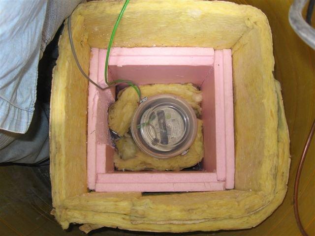
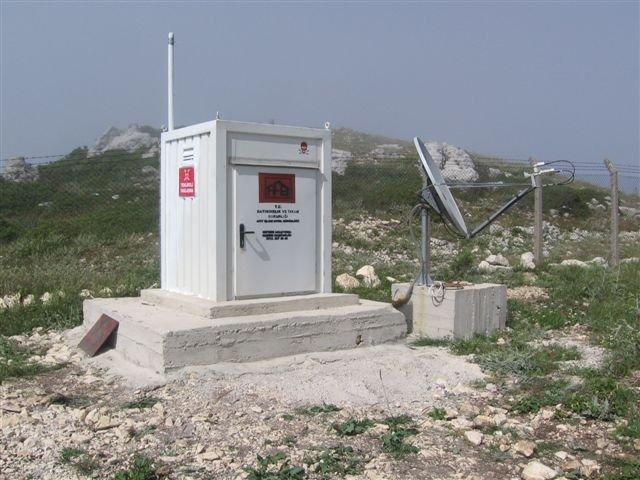
7 Stations and Instrumentations


8 Earthquake Watching System by Earthworm 2. STEP Earthworm runs and determines rapidly earthquake location. 1. STEP Scream sends data to Earthworm. 3. STEP This program shows earthquake location on the map and gives its information.


9 Network and System All seismic data has been observed 24 hours continuously and issued immediately the center of Seismology Division (


10 TURDEP THE RESEARCH PROJECT ON THE EARTHQUAKE BEHAVIOR OF THE REGIONS WITH HIGH SEISMIC RISK (GEO-STRATEGIC) BUT DIFFERENT TECTONIC REGIMES BY A MULTIDISCIPLINARY APPROACH For earthquake hazard reduction, it is aimed to observe earthquake activity and earthquake precursors by multidisciplinary studies related to the three main fault zones in our country and to introduce the earthquake hazard seriously in the regions under risk. Thus, a data base information will be obtained for a disaster management system in the international standards. 14 universities participate in this project which is supported by Tubitak- Marmara Research Center.
11 DEPAR IMMEDIATE OBSERVATION AND INVESTIGATIONS AFTER EARTHQUAKE GDDA-TUBITAK MARMARA RESEARCH CENTER AIM: For the cases which affect the settled areas in our country and given below: Earthquakes with magnitudes equal to or greater than 6.0 and cause loss of lives and damage, Earthquakes with magnitudes smaller than 6.0 and occur often in the same region which is called earthquake swarm and cause inconvenience in public as an unusual situation, To investigate the reasons of the damages in the buildings caused by the ground conditions after the earthquake, to determine the characteristics and behavior of earthquakes delicately, to constitute necessary measurements for the epicentral determination of the destructive aftershocks and immediate earthquake observation, to inform the authorities and public about the preliminary determinations and results Research Group (DEPAR) consists of four subgroups; Group for Earthquake Seismology Group for GPS Deformation Group for Accelerometers Group for Remote Sensing and Geological Mapping.

12 DEPAR Project BALA Earthquake Aftershock observation stations (Dec. 21, 2007)


13 BALA Earthquake Aftershock distributions (Dec. 20, Feb. 28 Şubat, 2008)
 To develop our present network for quick and correct determination of the epicentral parameters of earthquakes with M>3.")
14 Our Aim and Plans Seismicity of Turkey (M>4.0, ) To develop our present network for quick and correct determination of the epicentral parameters of earthquakes with M>3.0, To complete basic facilities for the waveform data exchange with the seismological Data Centers.

15 Thank you.
PRELIMINARY AFTERSHOCK ANALYSIS OF THE BALA - ANKARA EARTHQUAKES (DECEMBER 20, Ml=5.6, DECEMBER 27, 2007-Ml=5.5) IN CENTRAL TURKEY
 IN CENTRAL TURKEY") PRELIMINARY AFTERSHOCK ANALYSIS OF THE BALA - ANKARA EARTHQUAKES (DECEMBER 20, 2007 - Ml=5.6, DECEMBER 27, 2007-Ml=5.5) IN CENTRAL TURKEY S. ZÜNBÜL (sami@deprem.gov.tr ), C. ERKMEN, R.F. KARTAL, A.YATMAN,
PRELIMINARY AFTERSHOCK ANALYSIS OF THE BALA - ANKARA EARTHQUAKES (DECEMBER 20, 2007 - Ml=5.6, DECEMBER 27, 2007-Ml=5.5) IN CENTRAL TURKEY S. ZÜNBÜL (sami@deprem.gov.tr ), C. ERKMEN, R.F. KARTAL, A.YATMAN,
Scattering and intrinsic attenuation structure in Central Anatolia, Turkey using BRTR (PS-43) array
 array") Scattering and intrinsic attenuation structure in Central Anatolia, Turkey using BRTR (PS-43) array CTBT: Science & Technology 2011 Korhan Umut SEMIN Nurcan Meral OZEL B.U. Kandilli Observatory & Earthquake
Scattering and intrinsic attenuation structure in Central Anatolia, Turkey using BRTR (PS-43) array CTBT: Science & Technology 2011 Korhan Umut SEMIN Nurcan Meral OZEL B.U. Kandilli Observatory & Earthquake
A Multi-Purpose Continuous GPS Network within the boundary zones of the Eurasian, African, and Arabian plates
 A Multi-Purpose Continuous GPS Network within the boundary zones of the Eurasian, African, and Arabian plates Bahadır AKTUĞ General Command of Mapping TR06100 Ankara/Turkey http://www.hgk.mil.tr Anatolia,
GEO-VIII November Geohazard Supersites and Natural Laboratories Progress Report. Document 9
 GEO-VIII 16-17 November 2011 Geohazard Supersites and Natural Laboratories Progress Report Document 9 This document is submitted to GEO-VIII for information. Geohazard Supersites and Natural Laboratories
IGUT Seismic Network. Institute of Geophysics University of Tehran (IGUT) Mehdi Rezapour
 Mehdi Rezapour") IGUT Seismic Network Institute of Geophysics University of Tehran (IGUT) Mehdi Rezapour History of seismic monitoring in Iran The IGUT starts to record & Locate seismic events in the 1960 s using 5 WWSSN
IGUT Seismic Network Institute of Geophysics University of Tehran (IGUT) Mehdi Rezapour History of seismic monitoring in Iran The IGUT starts to record & Locate seismic events in the 1960 s using 5 WWSSN
PRELIMINARY REPORT. July 21th 2017 Bodrum Offshore Earthquake (Muğla-Turkey) Mw=6.5.
 Mw=6.5.") PRELIMINARY REPORT July 21th 2017 Bodrum Offshore Earthquake (Muğla-Turkey) Mw=6.5 www.deprem.gov.tr www.afad.gov.tr REPUBLIC OF TUKEY MANAGEMENT PRESIDENCY An earthquake with magnitude Mw=6.5 occurred
PRELIMINARY REPORT July 21th 2017 Bodrum Offshore Earthquake (Muğla-Turkey) Mw=6.5 www.deprem.gov.tr www.afad.gov.tr REPUBLIC OF TUKEY MANAGEMENT PRESIDENCY An earthquake with magnitude Mw=6.5 occurred
Wireless Networks in Geophysical Monitoring
 Workshop on New Frontiers in Internet of Things 7-18 March 2016 Trieste, Italy Wireless Networks in Geophysical Monitoring Hairo Villalobos Vulcanological and Seismological Observatory of Costa Rica, National
National Seismological Centre: An Overview, Prospects and Challenges
 National Seismological Centre: An Overview, Prospects and Challenges By Soma Nath Sapkota Department of Mines and Geology National Seismological Centre Nepal India Himalaya Tibetan Plateau India continental
The Hellenic Seismological Network of Crete (HSNC): Monitoring results and the new strong motion network
: Monitoring results and the new strong motion network") The Hellenic Seismological Network of Crete (HSNC): Monitoring results and the new strong motion network Georgios Chatzopoulos 1, Ilias Papadopoulos 1 and Filippos Vallianatos 1 1 Technological Educational
The Hellenic Seismological Network of Crete (HSNC): Monitoring results and the new strong motion network Georgios Chatzopoulos 1, Ilias Papadopoulos 1 and Filippos Vallianatos 1 1 Technological Educational
THE NEW DIGITAL SEISMIC NETWORK IN GHANA THE WAYFORWARD AND THE CHALLENGES
 THE NEW DIGITAL SEISMIC NETWORK IN GHANA THE WAYFORWARD AND THE CHALLENGES By NICHOLAS OPOKU Seismologist, Ghana Geological Survey JANUARY, 2013 IRIS METADATA WORKSHOP - KUWAIT Seismicity / Instrumental
Earthquake,Tsunami,Volcano Monitoring & Warning System in Korea. Jimin Lee Earthquake & Volcano Monitoring Division KMA
 Earthquake,Tsunami,Volcano Monitoring & Warning System in Korea Jimin Lee Earthquake & Volcano Monitoring Division KMA 1 2 Brief History & Vision of KMA Introduction of Services 3 Korea National Seismographic
Earthquakes, Tsunamis and Nuclear Explosions: Open Data Exchange for Research and Monitoring in Seismology
 Earthquakes, Tsunamis and Nuclear Explosions: Open Data Exchange for Research and Monitoring in Seismology David Simpson IRIS Consortium Washington, DC Symposium on Data Sharing Plans for GEOSS and Benefits
A STUDY OF RESIDUALS FOR STRONG GROUND MOTIONS IN ADAPAZARI BASIN, NW TURKEY, BY GROUND MOTION PREDICTION EQUATIONS (GMPEs) ABSTRACT
 ABSTRACT") A STUDY OF RESIDUALS FOR STRONG GROUND MOTIONS IN ADAPAZARI BASIN, NW TURKEY, BY GROUND MOTION PREDICTION EQUATIONS (GMPEs) ERGIN ULUTAŞ 1,2, ÖZKAN CORUK 3 AND AHMET KARAKAŞ 3 1 Department of Geophysical
A STUDY OF RESIDUALS FOR STRONG GROUND MOTIONS IN ADAPAZARI BASIN, NW TURKEY, BY GROUND MOTION PREDICTION EQUATIONS (GMPEs) ERGIN ULUTAŞ 1,2, ÖZKAN CORUK 3 AND AHMET KARAKAŞ 3 1 Department of Geophysical
HARMONIZATION OF SEISMIC HAZARD MAPS FOR THE WESTERN BALKAN COUNTRIES : Overview of main BSHAP results
 Zagreb, Croatia Hotel Sheraton 12-13 May 2011 NATO SfP Project no. 983054 HARMONIZATION OF SEISMIC HAZARD MAPS FOR THE WESTERN BALKAN COUNTRIES : Overview of main BSHAP results Prof. Branislav Glavatović,
PRELIMINARY REPORT ON March 8, 2010 ELAZIG EARTHQUAKES (EASTHERN TURKEY) PREPARED BY EARTHQUAKE DEPARTMENT WORKING GROUPS*
 PREPARED BY EARTHQUAKE DEPARTMENT WORKING GROUPS*") PRELIMINARY REPORT ON March 8, 1 ELAZIG EARTHQUAKES (EASTHERN TURKEY) PREPARED BY EARTHQUAKE DEPARTMENT WORKING GROUPS* * Disaster And Emergency Management Presıdency, Earthquake Department Presidency,
PRELIMINARY REPORT ON March 8, 1 ELAZIG EARTHQUAKES (EASTHERN TURKEY) PREPARED BY EARTHQUAKE DEPARTMENT WORKING GROUPS* * Disaster And Emergency Management Presıdency, Earthquake Department Presidency,
Design of Safety Monitoring and Early Warning System for Buried Pipeline Crossing Fault
 5th International Conference on Civil Engineering and Transportation (ICCET 2015) Design of Safety Monitoring and Early Warning System for Buried Pipeline Crossing Fault Wu Liu1,a, Wanggang Hou1,b *, Wentao
CYPRUS STRONG MOTION DATABASE: RESPONSE SPECTRA FOR SHORT RETURN PERIOD EVENTS IN CYPRUS
 CYPRUS STRONG MOTION DATABASE: RESPONSE SPECTRA FOR SHORT RETURN PERIOD EVENTS IN CYPRUS Ismail SAFKAN ABSTRACT Cyprus experienced many destructive earthquakes through its history. However the development
NATO SfP HARMONIZATION OF SEISMIC HAZARD MAPS FOR THE WESTERN BALKAN COUNTRIES (BSHAP)
") Information Day NATO Science for Peace and Security (SPS) Programme: Enhancing Partnership through Cooperation 4 February 2010, Istanbul/Turkey Suleyman Demirel Cultural Centre / Istanbul Technical University
Information Day NATO Science for Peace and Security (SPS) Programme: Enhancing Partnership through Cooperation 4 February 2010, Istanbul/Turkey Suleyman Demirel Cultural Centre / Istanbul Technical University
Widespread Ground Motion Distribution Caused by Rupture Directivity during the 2015 Gorkha, Nepal Earthquake
 Widespread Ground Motion Distribution Caused by Rupture Directivity during the 2015 Gorkha, Nepal Earthquake Kazuki Koketsu 1, Hiroe Miyake 2, Srinagesh Davuluri 3 and Soma Nath Sapkota 4 1. Corresponding
A note on ground motion recorded during Mw 6.1 Mae Lao (Northern Thailand) earthquake on 5 May 2014
 earthquake on 5 May 2014") Proceedings of the Tenth Pacific Conference on Earthquake Engineering Building an Earthquake-Resilient Pacific 6-8 November 2015, Sydney, Australia A note on ground motion recorded during Mw 6.1 Mae Lao
Proceedings of the Tenth Pacific Conference on Earthquake Engineering Building an Earthquake-Resilient Pacific 6-8 November 2015, Sydney, Australia A note on ground motion recorded during Mw 6.1 Mae Lao
7. Armutlu - A Key Region to Understand the Evolution of Seismicity at the Western End of the 1999 Izmit Earthquake Rupture
 7. Armutlu - A Key Region to Understand the Evolution of Seismicity at the Western End of the 1999 Izmit Earthquake Rupture Bari,. 1, S. Sandberg 2, H. Grosser 2, S. Irmak 1, H. Woith 2, M. F. Özer 1,
Seismological Study of Earthquake Swarms in South-Eastern Puerto Rico
 Seismological Study of Earthquake Swarms in South-Eastern Puerto Rico Principal Investigator: Lillian Soto-Cordero [1] Co-Investigators: Victor Huérfano 1, Leonardo Cano [2], Robert Watts [3], and Christa
The 2003, M W 7.2 Fiordland Earthquake, and its nearsource aftershock strong motion data
 The 2003, M W 7.2 Fiordland Earthquake, and its nearsource aftershock strong motion data P. McGinty Institute of Geological & Nuclear Sciences, PO Box 30-368, Lower Hutt, New Zealand 2004 NZSEE Conference
EARTHQUAKES! Tectonics, Faulting and Earthquakes
 Name: Student Number: Tectonics, Faulting and Earthquakes Purpose: To illustrate how the Earth s lithosphere is deformed by tectonic forces, and use real-time earthquake data from the internet to explore
Advantages of Regional and Global Data Exchange. Gavin Hayes U.S. Geological Survey, National Earthquake Information Center
 Advantages of Regional and Global Data Exchange Gavin Hayes U.S. Geological Survey, National Earthquake Information Center USGS NEIC Global Earthquake Response Area of responsibility => Global BUT - domestically,
Aftershock study and seismotectonic implications of the 8 March 2010 Kovancılar (Elazığ, Turkey) earthquake (M W = 6.1)
 earthquake (M W = 6.1)") GEOPHYSICAL RESEARCH LETTERS, VOL. 38,, doi:10.1029/2011gl047702, 2011 Aftershock study and seismotectonic implications of the 8 March 2010 Kovancılar (Elazığ, Turkey) earthquake (M W = 6.1) Onur Tan,
GEOPHYSICAL RESEARCH LETTERS, VOL. 38,, doi:10.1029/2011gl047702, 2011 Aftershock study and seismotectonic implications of the 8 March 2010 Kovancılar (Elazığ, Turkey) earthquake (M W = 6.1) Onur Tan,
GEM Faulted Earth. A Global Active Fault and Fault Source Database
 GEM Faulted Earth A Global Active Fault and Fault Source Database Marco Pagani on behalf of GEM Faulted Earth Kelvin Berryman, Carlos Costa, Kerry Sieh Nicola Litchfield, Annemarie Christophersen THIS
the IRIS Consortium Collaborative, Multi-user Facilities for Research and Education Briefing NSF Business Systems Review September 9, 2008
 the IRIS Consortium Collaborative, Multi-user Facilities for Research and Education Briefing NSF Business Systems Review September 9, 2008 A facilities program for collection and distribution of seismological
Characteristics and introduction of Earthquake in Asia-Pacific region
 Characteristics and introduction of Earthquake in Asia-Pacific region 1906 San Francisco 2011 Tohoku 1999 Chi-Chi 1985 Mexico City 2004 Sumatra Chung-Han Chan 詹忠翰 2011 Christchurch To understand the characteristics
Seismic Observation and Seismicity of Zimbabwe
 Seismic Observation and Seismicity of Zimbabwe Mr. Innocent Gibbon Tirivanhu MASUKWEDZA (2016 Global Seismology course) Meteorological Services Department of Zimbabwe 1. Introduction The Seismology section
Disaster Risk Reduction in Survey for Seismic Protection of MES
 Survey for Seismic Protection Ministry of Emergency Situations of Republic of Armenia Disaster Risk Reduction in Survey for Seismic Protection of MES Syuzanna Kakoyan Leading specialist at the Department
Seismic Activity and Crustal Deformation after the 2011 Off the Pacific Coast of Tohoku Earthquake
 J-RAPID Symposium March 6-7, 2013 Seismic Activity and Crustal Deformation after the 2011 Off the Pacific Coast of Tohoku Earthquake Y. Honkura Tokyo Institute of Technology Japan Science and Technology
RELOCATION OF THE MACHAZE AND LACERDA EARTHQUAKES IN MOZAMBIQUE AND THE RUPTURE PROCESS OF THE 2006 Mw7.0 MACHAZE EARTHQUAKE
 RELOCATION OF THE MACHAZE AND LACERDA EARTHQUAKES IN MOZAMBIQUE AND THE RUPTURE PROCESS OF THE 2006 Mw7.0 MACHAZE EARTHQUAKE Paulino C. FEITIO* Supervisors: Nobuo HURUKAWA** MEE07165 Toshiaki YOKOI** ABSTRACT
Lab 9: Satellite Geodesy (35 points)
") Lab 9: Satellite Geodesy (35 points) Here you will work with GPS Time Series data to explore plate motion and deformation in California. This lab modifies an exercise found here: http://www.unavco.org:8080/cws/pbonucleus/draftresources/sanandreas/
Lab 9: Satellite Geodesy (35 points) Here you will work with GPS Time Series data to explore plate motion and deformation in California. This lab modifies an exercise found here: http://www.unavco.org:8080/cws/pbonucleus/draftresources/sanandreas/
The Greek Supersite: An initiative from the most tectonically active part of Europe
 The Greek Supersite: An initiatie from the most tectonically actie part of Europe Alexandros Saaidis, PhD. Institute of Engineering Seismology and Earthquake Engineering, EPPO GEO-XIII Plenary Side Eents
Training System and Information Network for Earthquake Disaster Mitigation. Taiki SAITO. Building Research Institute (BRI)
") 1 Training System and Information Network for Earthquake Disaster Mitigation Taiki SAITO Chief Research Engineer, International Institute of Seismology and Earthquake Engineering (IISEE), Building Research
1 Training System and Information Network for Earthquake Disaster Mitigation Taiki SAITO Chief Research Engineer, International Institute of Seismology and Earthquake Engineering (IISEE), Building Research
GROUND MOTION TIME HISTORIES FOR THE VAN NUYS BUILDING
 GROUND MOTION TIME HISTORIES FOR THE VAN NUYS BUILDING Prepared for the PEER Methodology Testbeds Project by Paul Somerville and Nancy Collins URS Corporation, Pasadena, CA. Preliminary Draft, Feb 11,
CONSTRUCTION OF A DATA BASE SYSTEM FOR IRRIGATION DAMS
 CONSTRUCTION OF A DATA BASE SYSTEM FOR IRRIGATION DAMS TANI SHIGERU 1 SUMMARY The Hyogo-Ken Nambu Earthquake damaged many earthen structures. The Japanese Society of Civil Engineers stated that databases
National Earthquake Monitoring for Tsunami Early Warning. Burin Wechbunthung Sumalee Prachaub Seismological Bureau, Thai Meteorological Department
 National Earthquake Monitoring for Tsunami Early Warning Burin Wechbunthung Sumalee Prachaub Seismological Bureau, Thai Meteorological Department Seismic Sources Out line Historical Earthquake Damage from
PRELIMINARY REPORT. September, 17, 2013 Muş Earthquake (Eastern Part of Turkey) Ml=
 Ml=") PRELIMINARY REPORT September, 17, 2013 Muş Earthquake (Eastern Part of Turkey) Ml=5.1 www.deprem.gov.tr www.afad.gov.tr REPUBLIC OF TUKEY MANAGEMENT PRESIDENCY An earthquake with magnitude Ml=5.1 occurred
PRELIMINARY REPORT September, 17, 2013 Muş Earthquake (Eastern Part of Turkey) Ml=5.1 www.deprem.gov.tr www.afad.gov.tr REPUBLIC OF TUKEY MANAGEMENT PRESIDENCY An earthquake with magnitude Ml=5.1 occurred
EARTH OBSERVATION SERVICES IN REPUBLIC OF MOLDOVA
 EARTH OBSERVATION SERVICES IN REPUBLIC OF MOLDOVA Vasile ALCAZ 1 Ion APOSTOL 2 1 Institute of Geology and Seismology Moldavian Academy of Sciences 2 Ministry of Environment and Natural Resources Republic
Empirical ground-motion prediction equations for Northwestern. Turkey using the aftershocks of the 1999 Kocaeli earthquake
 1 2 3 4 5 6 7 8 9 10 11 12 13 14 15 16 17 18 19 Empirical ground-motion prediction equations for Northwestern Turkey using the aftershocks of the 1999 Kocaeli earthquake D. Bindi (1), S. Parolai (2), H.
The IISEE earthquake catalog, Catalog of Damaging Earthquakes in the World, IISEE-NET,, and BRI strong motion observation
 The IISEE earthquake catalog, Catalog of Damaging Earthquakes in the World, IISEE-NET,, and BRI strong motion observation Tatsuhiko Hara International Institute of Seismology and Earthquake Engineering,
Recent GNSS Developments and Reference Frame Issues in Turkey. Onur LENK and Bahadir AKTUĞ
 Recent GNSS Developments and Reference Frame Issues in Turkey Onur LENK and Bahadir AKTUĞ General Command of Mapping onur.lenk lenk@hgk.mil.tr 1/31 GPS STUDIES İN TURKEY date back to early 1990s geodynamics-oriented
INTRODUCTION OF A SUCCESS STORY IN THE PHILIPPINES
 INTRODUCTION OF A SUCCESS STORY IN THE PHILIPPINES Arturo S. Daag Department of Science and Technology Philippine Institute of Volcanology and Seismology (DOST-PHIVOLCS) Establishment of Sentinel Asia
Rupture processes of the 1999 August 17 Izmit and November 12 DuÈ zce Turkey) earthquakes
 earthquakes") Geophys. J. Int. 2001) 144, F1±F7 FAST-TRACK PAPER Rupture processes of the 1999 August 17 Izmit and November 12 DuÈ zce Turkey) earthquakes R. Tibi, 1, * G. Bock, 1 Y. Xia, 1 M. Baumbach, 1 H. Grosser,
Geophys. J. Int. 2001) 144, F1±F7 FAST-TRACK PAPER Rupture processes of the 1999 August 17 Izmit and November 12 DuÈ zce Turkey) earthquakes R. Tibi, 1, * G. Bock, 1 Y. Xia, 1 M. Baumbach, 1 H. Grosser,
CHILEAN PART OF SIRGAS REFERENCE FRAME, REALIZATION, ADOPTION, MAINTENANCE AND ACTUAL STATUS. Geodesy for Planet Earth IAG 2009, Buenos Aires
 CHILEAN PART OF SIRGAS REFERENCE FRAME, REALIZATION, ADOPTION, MAINTENANCE AND ACTUAL STATUS Geodesy for Planet Earth IAG 2009, Buenos Aires Ing. Héctor Parra hparra@igm.cl, IGM Chile Dr. Juan Báez jbaez@udec.cl,
Earthquake patterns in the Flinders Ranges - Temporary network , preliminary results
 Earthquake patterns in the Flinders Ranges - Temporary network 2003-2006, preliminary results Objectives David Love 1, Phil Cummins 2, Natalie Balfour 3 1 Primary Industries and Resources South Australia
APPLICATION OF RECEIVER FUNCTION TECHNIQUE TO WESTERN TURKEY
 APPLICATION OF RECEIVER FUNCTION TECHNIQUE TO WESTERN TURKEY Timur TEZEL Supervisor: Takuo SHIBUTANI MEE07169 ABSTRACT In this study I tried to determine the shear wave velocity structure in the crust
Surface Anomalies Prior to Earthquakes
 Surface Anomalies Prior to Earthquakes Habibeh Valizadeh, Shattri B. Mansor Husaini Omar and Farid Azad Department of Civil Engineering Universiti Putra Malaysia Serdang, Selangor Malaysia shattri@eng.upm.edu.my
Preliminary Earthquake Risk Management Strategy Plan of Eskisehir, Turkey by using GIS
 Preliminary Earthquake Risk Management Strategy Plan of Eskisehir, Turkey by using GIS Metin Altan, Ferah Özturk and Can Ayday Space and Satellite Sciences Research Institute Anadolu University, TURKEY
GEOLOGICAL SURVEY OF IRAN
 MINISTRY OF INDUSTRY AND MINES GEOLOGICAL SURVEY OF IRAN TECTONIC,AND SEISMOTECTONIC SECTION CONTRIBUTION TO THE SEISMOTECTONICS OF man (PART II) BY M. BERBERIAN IN COMMEMORATION OF THE 50 TM ANNIVERSARY
Actual practices of seismic strong motion estimation at NPP sites
 ANSN Regional Workshop on Site Selection and Evaluation for Nuclear Power Plants June 2010, Hanoi Vietnam IAEA/ISSC Actual practices of seismic strong motion estimation at NPP sites Yoshi. FUKUSHIMA (JNES)
Magnitude 7.5 PALU, INDONESIA
 A magnitude 7.5 earthquake occurred 80.8 km (50.2 mi) north of Palu, Indonesia at a depth of 10 km (6.2 miles). This earthquake triggered a tsunami with wave heights up to 2 m (6.6 ft) that an official
CATALOG OF EARTHQUAKES IN DELAWARE
 State of Delaware DELAWARE GEOLOGICAL SURVEY Robert R. Jordan, State Geologist SERVICE RESEARCH DELAWARE GEOLOGICAL SURVEY EXPLORATION OPEN FILE REPORT NO. 42 CATALOG OF EARTHQUAKES IN DELAWARE by Stefanie
EARTHQUAKE CLUSTERS, SMALL EARTHQUAKES
 EARTHQUAKE CLUSTERS, SMALL EARTHQUAKES AND THEIR TREATMENT FOR HAZARD ESTIMATION Gary Gibson and Amy Brown RMIT University, Melbourne Seismology Research Centre, Bundoora AUTHORS Gary Gibson wrote his
LOCAL MAGNITUDE SCALE FOR MONGOLIA AND DETERMINATION OF M WP AND M S (BB)
") Synopses of Master Papers Bulletin of IISEE, 47, 31-36, 2013 LOCAL MAGNITUDE SCALE FOR MONGOLIA AND DETERMINATION OF M WP AND M S (BB) Dashdondog Mungunsuren MEE11606 Supervisor: Tatsuhiko HARA ABSTRACT
Synopses of Master Papers Bulletin of IISEE, 47, 31-36, 2013 LOCAL MAGNITUDE SCALE FOR MONGOLIA AND DETERMINATION OF M WP AND M S (BB) Dashdondog Mungunsuren MEE11606 Supervisor: Tatsuhiko HARA ABSTRACT
ENGINEERING-SEISMOLOGICAL ASPECTS OF EARTHQUAKE SCENARIO DEVELOPMENT ON THE EXAMPLE OF TASHKENT, UZBEKISTAN
 International Journal of Geology, Earth & Environmental Sciences ISSN: 2277-281 (Online) 218 Vol. 8 (2) May-August, pp. 3-35/Alixanovich ENGINEERING-SEISMOLOGICAL ASPECTS OF EARTHQUAKE SCENARIO DEVELOPMENT
Earthquakes. Earthquake Magnitudes 10/1/2013. Environmental Geology Chapter 8 Earthquakes and Related Phenomena
 Environmental Geology Chapter 8 Earthquakes and Related Phenomena Fall 2013 Northridge 1994 Kobe 1995 Mexico City 1985 China 2008 Earthquakes Earthquake Magnitudes Earthquake Magnitudes Richter Magnitude
External Grant Award Number 01HQAG0009 WESTERN GREAT BASIN SEISMIC NETWORK OPERATIONS. December 1, 2000 to November 30, 2001
 External Grant Award Number 01HQAG0009 WESTERN GREAT BASIN SEISMIC NETWORK OPERATIONS December 1, 2000 to November 30, 2001 Glenn P. Biasi University of Nevada Reno Seismological Laboratory MS-174 Reno,
GPS study of N-S trending Karaburun Belt (Turkey) and its E-W trending eastern part
 and its E-W trending eastern part") Presented at the FIG Working Week 2017, GPS study of N-S trending Karaburun Belt (Turkey) and its E-W trending eastern part May 29 - June 2, 2017 in Helsinki, Finland Muzaffer KAHVECİ Selcuk University,
Presented at the FIG Working Week 2017, GPS study of N-S trending Karaburun Belt (Turkey) and its E-W trending eastern part May 29 - June 2, 2017 in Helsinki, Finland Muzaffer KAHVECİ Selcuk University,
Investigation of Seismic Hazard in NW-Himalayas, Pakistan using Gumbel s First Asymptotic Distribution of Extreme Values
 Pakistan Journal of Meteorology Vol. 6, Issue 12 Investigation of Seismic Hazard in NW-Himalayas, Pakistan using Gumbel s First Asymptotic Distribution of Extreme Values Naseer Ahmed 1, Dr. Zulfiqar Ahmed
Yoshimitsu Fukushima 1, Onur Köse 2,TekinYürür 2, Philippe Volant 3, Edward Cushing 3 & Richard Guillande 4
 Journal of Seismology 6: 379 396, 2002. 2002 Kluwer Academic Publishers. Printed in the Netherlands. 379 Attenuation characteristics of peak ground acceleration from fault trace of the 1999 Kocaeli (Turkey)
PROBABILISTIC LIQUEFACTION HAZARD ANALYSIS IN JAPAN
 SECED 2015 Conference: Earthquake Risk and Engineering towards a Resilient World 9-10 July 2015, Cambridge UK PROBABILISTIC LIQUEFACTION HAZARD ANALYSIS IN JAPAN Tetsushi KURITA 1 and Sei ichiro FUKUSHIMA
Earthquakes in Canada
 Earthquakes in Canada Maurice Lamontagne, Ph.D., ing. Geological Survey of Canada Natural Resources Canada 1 What is an Earthquake? P S P S P PS 2 2 Movement on a fault plane causes vibrations The larger
Agency Vision and Decision- Maker Needs: A USGS Perspective
 Agency Vision and Decision- Maker Needs: A USGS Perspective Connecting Grassroots to Government for Disaster Management David Applegate USGS Associate Director for Natural Hazards September 13, 2012 U.S.
Magnitude 7.1 SOUTH SANDWICH ISLANDS
 A magnitude 7.1 earthquake occurred at a depth of 164.7 km (102 miles) in the South Sandwich Islands, an uninhabited British territory off the coast of Argentina in the southern Atlantic Ocean. Antarctica
Slip Rates Estimate of Western North Anatolian Fault System in Turkey
 Slip Rates Estimate of Western North Anatolian Fault System in Turkey Haluk OZENER, Asli DOGRU, Bahadir AKTUG, Semih ERGINTAV, Bulent TURGUT, Onur YILMAZ, Kerem HALICIOGLU, Onur GURKAN, Turkey Keywords:
J M MIRANDA UNIVERSITY OF LISBON THE USE OF REMOTE SENSING FOR EARTHQUAKE RISK ASSESSMENT AND MITIGATION
 1 THE USE OF REMOTE SENSING FOR EARTHQUAKE RISK ASSESSMENT AND MITIGATION 2 the observation of strong ground motion and aftershock sequences as well as the investigation of the destruction from these earthquakes
Structural behavior of a high-rise RC structure under vertical earthquake motion
 Structural behavior of a high-rise RC structure under vertical earthquake motion Selcuk Bas 1), Ilker Kalkan 2) and *Jong-Han Lee 3) 1) Department of Civil Engineering, Bartin University, 74100 Central,
Usually, only a couple of centuries of earthquake data is available, much shorter than the complete seismic cycle for most plate motions.
 Earthquake Hazard Analysis estimate the hazard presented by earthquakes in a given region Hazard analysis is related to long term prediction and provides a basis to expressed hazard in probabilistic terms.
Analysis Of Earthquake Records of Istanbul Earthquake Rapid Response System Stations Related to the Determination of Site Fundamental Frequency
 Analysis Of Earthquake Records of Istanbul Earthquake Rapid Response System Stations Related to the Determination of Site Fundamental Frequency A. C. Zulfikar, H. Alcik & E. Cakti Bogazici University,Kandilli
IMPLEMENT ROUTINE AND RAPID EARTHQUAKE MOMENT-TENSOR DETERMINATION AT THE NEIC USING REGIONAL ANSS WAVEFORMS
 Final Technical Report Award number: 05HQGR0062 IMPLEMENT ROUTINE AND RAPID EARTHQUAKE MOMENT-TENSOR DETERMINATION AT THE NEIC USING REGIONAL ANSS WAVEFORMS Lupei Zhu Saint Louis University Department
History of International Training in Seismology and Earthquake Engineering at IISEE
 History of International Training in Seismology and Earthquake Engineering at IISEE Activities of International Institute of Seismology and Earthquake Engineering (IISEE), BRI - Training for young researchers/engineers
Lecture 4: Earthquakes and Seismic Waves
 Lecture 4: Earthquakes and Seismic Waves Key Questions 1. What are the sources for EQs in the PNW? 2. What is a seismograph and seismogram? 3. What is the difference between Richter magnitudes and Mercalli
GROUND MOTION. based on National Network station basis.
 The October 23, 211 Van, Turkey Earthquake (Mw=7.2) STRONG GROUND MOTION Distribution of estimated peak ground accelerations and peak ground velocities associated with the mainshock are shown in Figures
Status and Challenges on Geo-DRM Information Systems in Tonga
 Name: Mafua- i-vai utukakau Maka Status and Challenges on Geo-DRM Information Systems in Tonga 1 Roles and Relationships Land and Geographic Information Systems (LGIS) Unit: Establish updated high-resolution
M-6.2 EARTHQUAKE NORCIA, ITALY AUGUST 24, 01:36:33 UTC
 M-6.2 EARTHQUAKE NORCIA, ITALY AUGUST 24, 2016 @ 01:36:33 UTC EARTHQUAKE REPORT - NORCIA, ITALY M-6.2, 24 August 2016 The M-6.2 earthquake had a shallow depth (10 km) and struck approximately 10 km SE
Earthquakes Web Quest
 NAME: Earthquakes Web Quest DATE: TASK #1: http://projects.crustal.ucsb.edu/understanding/history/historyhtml Read through the slides and answer the following questions: What did our ancient ancestors
REAL-TIME ASSESSMENT OF EARTHQUAKE DISASTER IN YOKOHAMA BASED ON DENSE STRONG-MOTION NETWORK
 REAL-TIME ASSESSMENT OF EARTHQUAKE DISASTER IN YOKOHAMA BASED ON DENSE STRONG-MOTION NETWORK Saburoh MIDORIKAWA 1 And Susumu ABE 2 SUMMARY This paper describes a system for REal-time Assessment of earthquake
A Short Story About Earthquakes Ein kurzer Vortrag über Erdbeben
 A Short Story About Earthquakes Ein kurzer Vortrag über Erdbeben Wolfgang Rattay Reuters BBC Kurt Decker Universität Wien Department für Geodynamik und Sedimentologie The short sumary of a short story
Establishment and Operation of a Regional Tsunami Warning Centre
 Establishment and Operation of a Regional Tsunami Warning Centre Dr. Charles McCreery, Director NOAA Richard H. Hagemeyer Pacific Tsunami Warning Center Ewa Beach, Hawaii USA Why A Regional Tsunami Warning
SOURCE INVERSION AND INUNDATION MODELING TECHNOLOGIES FOR TSUNAMI HAZARD ASSESSMENT, CASE STUDY: 2001 PERU TSUNAMI
 Paper No. TS-4-1 SOURCE INVERSION AND INUNDATION MODELING TECHNOLOGIES FOR TSUNAMI HAZARD ASSESSMENT, CASE STUDY: 2001 PERU TSUNAMI Bruno Adriano 1, Shunichi Koshimura 2 and Yushiro Fujii 3 ABSTRACT The
Application of a GIS for Earthquake Hazard Assessment and Risk Mitigation in Vietnam
 Application of a GIS for Earthquake Hazard Assessment and Risk Mitigation in Vietnam Nguyen Hong Phuong Earthquake Information and Tsunami Warning Centre, VAST OUTLINE Introduction Fault Source Model and
Deterministic Seismic Hazard Assessment of Quetta, Pakistan
 Deterministic Seismic Hazard Assessment of Quetta, Pakistan M.A. Shah Micro Seismic Studies Programme, Islamabad, Pakistan Pakistan Institute of Engineering and Applied Sciences, Islamabad, Pakistan M.
South Carolina Seismic Network Bulletin
 South Carolina Seismic Network Bulletin Volume XIII 2003 Prepared by: Pradeep Talwani Abhijit Gangopadhyay and Richard Cannon SPONSORS: Department of Energy/Westinghouse Savannah River Company United States
Probabilistic Seismic Hazard Maps in Dam Foundation
 Probabilistic Seismic Hazard Maps in Dam Foundation by Hideaki Kawasaki 1, Masafumi Kondo 2, Akira Nakamura 3, Kenji Inagaki 4 ABSTRACT Because Japan is one of the world s most earthquake prone countries,
Report for 15th PCGIAP Meeting at 18th UNRCC-AP Working Group 1 Regional Geodesy
 Report for 15th PCGIAP Meeting at 18th UNRCC-AP Working Group 1 Regional Geodesy Chairman Shigeru Matsuzaka, Japan - shigeru@gsi.go.jp Vice Chairman Prof. Pengfei Cheng, China - chengpf@casm.ac.cn John
Mw 7.8, Southwest of Sumatra, Indonesia Wed, 2 March 2016 at 12:49:48 UTC M /03/03
 Earthquake overview AFGHANISTA N PAKISTA N INDIA A moment magnitude (Mw) 7.8 earthquake struck in South West, Indonesia. The epicentre was centered about 800 km West South West of Padang, Sumatra province,
Challenges and Strategies for Monitoring Induced Seismic Activity
 Challenges and Strategies for Monitoring Induced Seismic Activity Designing and operating induced seismic monitoring networks to meet regulations Dario Baturan Geophysical Society of Tulsa 2015 Introduction
Ali Osman Oncel, MS & PhD Geophysicist KFUPM, ESD, Dhahran, PO Box: 1946, Saudi Arabia Tel.: (966)
") Ali Osman Oncel, MS & PhD Geophysicist KFUPM, ESD, 31261 Dhahran, PO Box: 1946, Saudi Arabia Tel.: (966) 3-860-1661 E-mail: oncel@kfupm.edu.sa PERSONAL DATA SUMMARY OF SKILLS Born: Istanbul, Turkey, September
Ali Osman Oncel, MS & PhD Geophysicist KFUPM, ESD, 31261 Dhahran, PO Box: 1946, Saudi Arabia Tel.: (966) 3-860-1661 E-mail: oncel@kfupm.edu.sa PERSONAL DATA SUMMARY OF SKILLS Born: Istanbul, Turkey, September
DUBAI SEISMIC NETWORK (DSN)
") DUBAI SEISMIC NETWORK (DSN) Eman Al Khatibi 1, Kamal Abou Elenean 1 1 Dubai Municipality, Survey Department, P.O. Box: 67 Dubai U.A.E. 8 th Gulf Seismic Forum, 3-6 March 2013, Muscat-Sultanate of Oman
DUBAI SEISMIC NETWORK (DSN) Eman Al Khatibi 1, Kamal Abou Elenean 1 1 Dubai Municipality, Survey Department, P.O. Box: 67 Dubai U.A.E. 8 th Gulf Seismic Forum, 3-6 March 2013, Muscat-Sultanate of Oman
Magnitude 7.4 SOUTH GEORGIA ISLAND REGION
 A magnitude 7.4 earthquake occurred in the South Georgia Island Region. South Georgia Island is a British territory in the South Atlantic Ocean that lies about 800 miles east of the Falkland Islands. It
Determining the Earthquake Epicenter: Japan
 Practice Name: Hour: Determining the Earthquake Epicenter: Japan Measuring the S-P interval There are hundreds of seismic data recording stations throughout the United States and the rest of the world.
TSUNAMI HAZARD ASSESSMENT FOR THE CENTRAL COAST OF PERU USING NUMERICAL SIMULATIONS FOR THE 1974, 1966 AND 1746 EARTHQUAKES
 TSUNAMI HAZARD ASSESSMENT FOR THE CENTRAL COAST OF PERU USING NUMERICAL SIMULATIONS FOR THE 1974, 1966 AND 1746 EARTHQUAKES Sheila Yauri Supervisor: Yushiro FUJII MEE10521 Bunichiro SHIBAZAKI ABSTRACT
Earthquake prediction through Kannan-Mathematical-Model Analysis and Dobrovolsky-based clustering Technique
 Earthquake prediction through Kannan-Mathematical-Model Analysis and Dobrovolsky-based clustering Technique Jacenth Mejia 1*, Kurt Rojas 1, Nadia Valeza 1, and Al Rey Villagracia 1 1 Physics Department,
SEISMIC RISK ASSESSMENT IN ARMENIA
 SEISMIC RISK ASSESSMENT IN ARMENIA Hovhannes Khangeldyan Head of National Crisis Management Center Rescue Service Ministry of Emergency Situations of the Republic of Armenia Tokyo, 2016 ARMENIA: GEOGRAPHICAL
STRUCTURAL DEFORMATION MONITORING ANALYSIS USING GEODETIC TECHNIQUES AFTER THE EARTHQUAKE AT BOLU PASS OF TRANS-EUROPEAN MOTORWAY
 STRUCTURAL DEFORMATION MONITORING ANALYSIS USING GEODETIC TECHNIQUES AFTER THE EARTHQUAKE AT BOLU PASS OF TRANS-EUROPEAN MOTORWAY Esra TEKDAL EMNĐYETĐ, Rahmi Nurhan CELĐK and Tevfik AYAN Istanbul Technical
Earthquake Focal Mechanisms and Waveform Modeling
 Earthquake Focal Mechanisms and Waveform Modeling Rengin Gök Lawrence Livermore National Laboratory USA RELEMR Workshop İstanbul 2008 Gudmundar E. Sigvaldason The Dynamic Earth, USGS The size of the event
The 2016, October 26, Central Italy Earthquake Origin Time 17:10:36 UTC, M L(ISNet) =5.3; M W(ISNet) =5.6
 =5.3; M W(ISNet) =5.6") The 2016, October 26, Central Italy Earthquake Origin Time 17:10:36 UTC, M L(ISNet) =5.3; M W(ISNet) =5.6 RISSC-Lab: Laboratorio di RIcerca in Sismologia Sperimentale e Computazionale The event as seen
The 2016, October 26, Central Italy Earthquake Origin Time 17:10:36 UTC, M L(ISNet) =5.3; M W(ISNet) =5.6 RISSC-Lab: Laboratorio di RIcerca in Sismologia Sperimentale e Computazionale The event as seen