Agency Vision and Decision- Maker Needs: A USGS Perspective
|
|
|
- Sheryl Parker
- 5 years ago
- Views:
Transcription


1 Agency Vision and Decision- Maker Needs: A USGS Perspective Connecting Grassroots to Government for Disaster Management David Applegate USGS Associate Director for Natural Hazards September 13, 2012 U.S. Department of the Interior U.S. Geological Survey
 warnings.")
2 USGS hazard roles and responsibilities Delegated federal responsibility to provide notifications and warnings for earthquakes, volcanic eruptions, and landslides. Seismic networks support NOAA s tsunami warnings. Streamgages and storm surge monitors support NOAA s flood and severe weather (including hurricane) warnings. Geomagnetic observatories support NOAA and AFWA geomagnetic storm forecasts. USGS has key role in tracking zoonotic diseases. Geospatial information supports response operations for wildfire and many other disasters.
3 Crowdsourced Data and Social Media: An Infrastructure for Hazard Assessment, Monitoring, and Response Did You Feel It? Did You See It? USGS TED: Tweet Earthquake Dispatch Quake Catcher Network Netquake Sensor Volunteers National Map Corps


4 Did You Feel It? Rapid & automatic intensity maps based on felt reports submitted online. Users answer simple online questionnaire. Color-code ZIP-code to community s average intensity. Replaces traditional postal questionnaire. M5.8 Virginia Aug, 2011
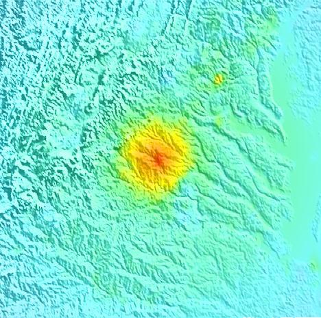
5
6 ShakeMap Did You Feel It?

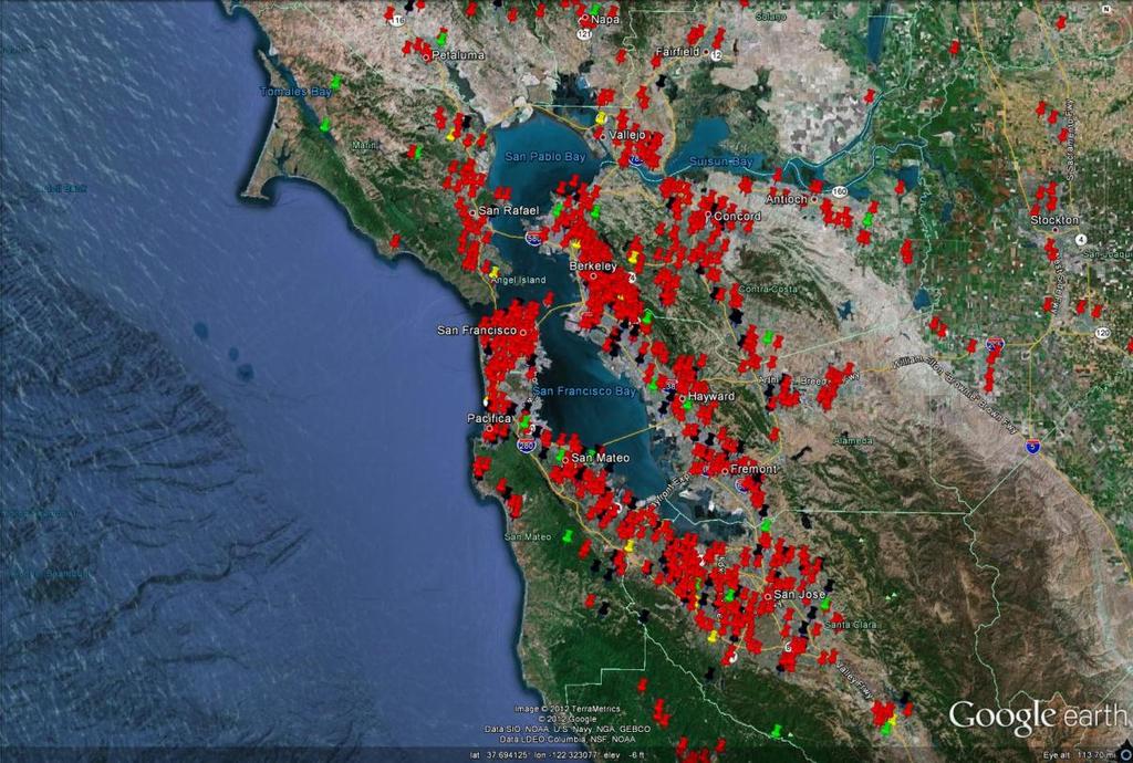
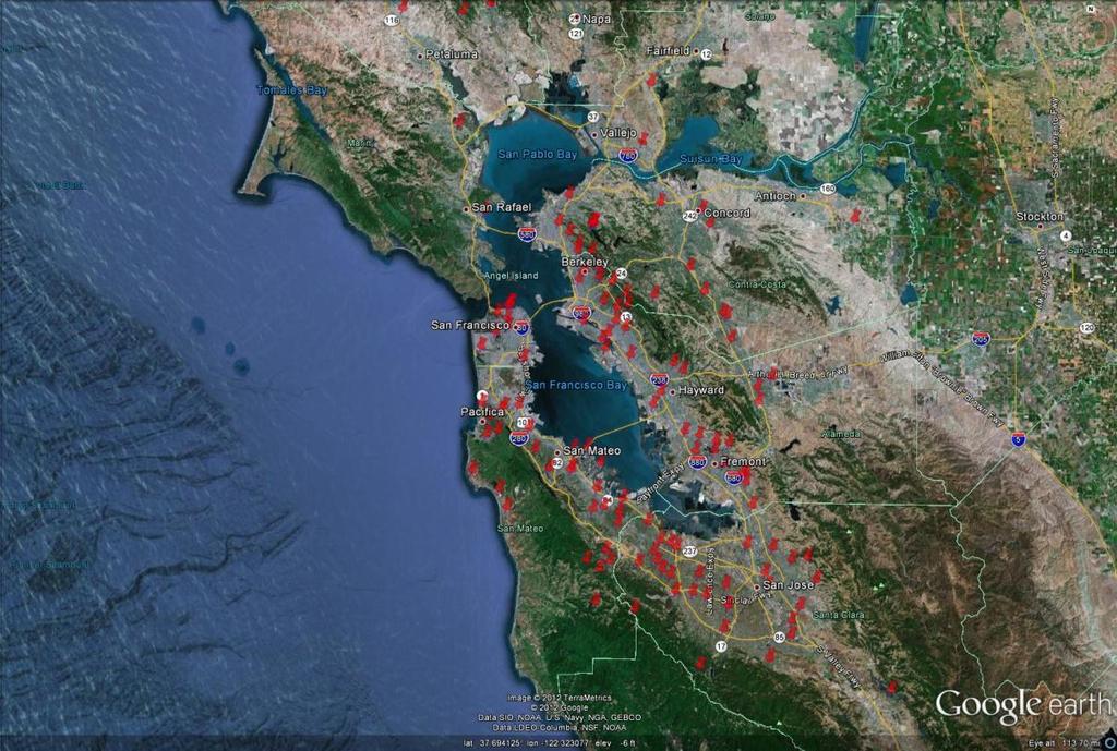
7 10 Years of DYFI Data (~2 million responses) USGS National Seismic Hazard Map (2% in 50 Year Probability of Exceedence)

8 Did You See It? Landslide Reporting Enables crowd-sourced, online landslide reports Qualitative information may be used in USGS reports

9 TED: Tweet Earthquake Dispatch Alerts for earthquakes worldwide with M Magnitude descriptor, location, origin time, link to USGS webpage. Alerts include frequency of tweets in event region that contain the word earthquake or its equivalent in several languages.
10 USGS TED Example: Philippines Quake

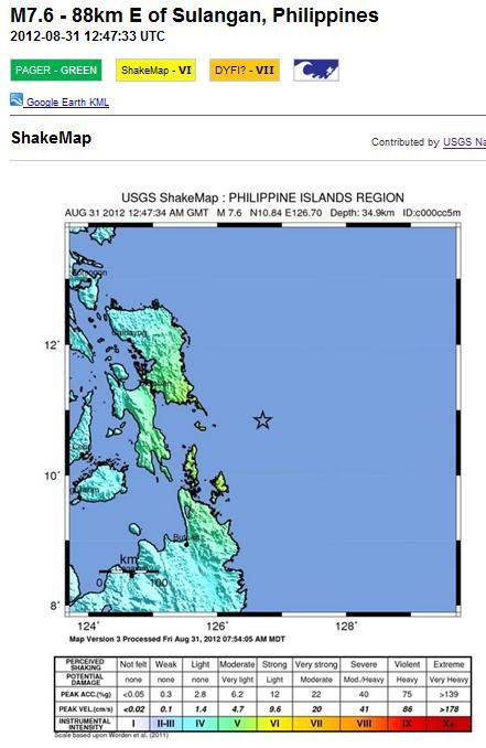
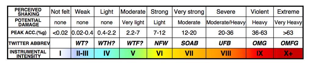
11 USGS TED Example: Philippines Quake


12 Other Citizen-aided science: Cheap seismic sensors QuakeCatcher Network (Stanford Univ.) ishake (U.C. Berkeley) NetQuakes (USGS) $ $$ $$$


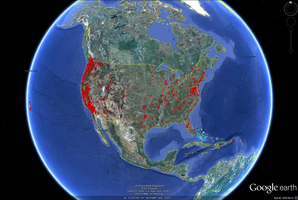
13 Distribution of QCN Participants Participants Earthquake Locations Statistics Over 2000 seismic stations globally in 67 countries Recorded earthquakes between M 2.6 (New Zealand) M 8.8 (Chile)
14 NetQuakes Volunteers


15 National Map Corps Crowdsourcing used to update USGS geographic data Volunteers mapping structures Pilot program in CO Improved map quality
16 Any questions?
17 Did You Feel It? Statistics Operating in CA since 1999; US since 2001, & globally 2005 To date >2 million individual responses from all 50 U.S. States & Territories. Outside the U.S., over 190,000 responses in 9,500 cities for 140 countries. 40 U.S. earthquakes with >10,000 reports submitted; 300 events with > 1,000 entries. Max=142,000 reports submitted Aug , M5.8 Virginia event (45,000/hr; ~750 per min; ~13/sec). D. Wald, USGS
18 Did You Feel It? Capabilities Immediate feedback, heads up on events within 1 min, around the globe. Intensity maps are immediately available; update constantly. USGS can now automatically collect intensity data for all felt earthquakes in U.S. Magnitude <2.0 events reported in Central & Eastern US (well below routine reporting level for most seismic networks). Can capture felt reports for non-earthquake related shaking: Sonic booms (shuttle; military aircraft) & bolides; explosions & quarry blasts. Allows immediate, quality & cost effective way of collecting a large quantity of macroseismic intensity data, replacing postal questionnaires. [USGS can still assign values from field/engineering surveys] We can automatically geocode entries to latitude/longitude for higher spatial resolution, as needed. D. Wald, USGS
19 Did You Feel It? Reasons for Success From our experience with DYFI, essential components of an internet-based citizen-science portal include: Easy-to-use forms, & instantaneous feedback so that users may see their contribution (validating their experience), Ability to see one s contribution (but not full responses), Open space for first-person accounts (catharsis; risk perception), User-friendly tools: common searches, statistics, sorting of responses, time-entry histories, comparing data with empirical intensity estimates, Easily-downloadable data exchange format for researchers. MOTHER NATURE GETS PEOPLES ATTENTION! D. Wald, USGS
 network: Involves the public in seismic data collection by installing sensor in homes,")

20 Graves and Somerville (2006), visualization by Chourasia (SDSC) Quake-Catcher Network Website: QCN Dense strong-motion (M>3) network: Involves the public in seismic data collection by installing sensor in homes, businesses and schools Small, low-cost sensors are connected to desktop computers and plug computer Objectives: Community understanding of earthquake risk and seismology Rapid earthquake detection and characterization Earthquake source imaging Wave propagation and seismic hazard
Citizen Science at the. U.S. Geological Survey
 Citizen Science at the U.S. Geological Survey David Applegate USGS Associate Director for Natural Hazards NRC Board on Earth Science & Resources December 5, 2014 U.S. Department of the Interior U.S. Geological
Complete Weather Intelligence for Public Safety from DTN
 Complete Weather Intelligence for Public Safety from DTN September 2017 White Paper www.dtn.com / 1.800.610.0777 From flooding to tornados to severe winter storms, the threats to public safety from weather-related
Smart use of Geographic Information System (GIS) platform for delivering weather information and nowcasting services
 platform for delivering weather information and nowcasting services") Smart use of Geographic Information System (GIS) platform for delivering weather information and nowcasting services C. K. Pan Hong Kong Observatory Hong Kong, China It is a world of beauty Source: Image
Smart use of Geographic Information System (GIS) platform for delivering weather information and nowcasting services C. K. Pan Hong Kong Observatory Hong Kong, China It is a world of beauty Source: Image
Overview. Tools of the Trade. USGS Decision-Making Tools for Pre-Earthquake Mitigation and Post-Earthquake Response
 USGS Decision-Making Tools for Pre-Earthquake Mitigation and Post-Earthquake Response Tools of the Trade DAVID WALD United States Geological Survey NEHRP Workshop: Developing Earthquake Scenarios Sept
ShakeAlert Earthquake Early Warning
 ShakeAlert Earthquake Early Warning Doug Given USGS, Pasadena Earthquake Program, Early Warning Coordinator 10 seconds 50 seconds 90 seconds USGS Earthquake Hazard Responsibilities USGS has the lead federal
The U.S. Geological Survey (USGS) National Earthquake Information Center (NEIC)
 National Earthquake Information Center (NEIC)") The U.S. Geological Survey (USGS) National Earthquake Information Center (NEIC) Gavin Hayes U.S. Geological Survey, National Earthquake Information Center NEIC Mission NEIC - The People 24x7 Operations
The U.S. Geological Survey (USGS) National Earthquake Information Center (NEIC) Gavin Hayes U.S. Geological Survey, National Earthquake Information Center NEIC Mission NEIC - The People 24x7 Operations
Earth Observation for Emergency Response and the International Charter on Space and Major Disasters.
 Earth Observation for Emergency Response and the International Charter on Space and Major Disasters. Case studies of the 2016 Alberta wildfires and 2017 Québec flooding Simon Tolszczuk-Leclerc 1, Brad
Assessing Hazards and Risk
 Page 1 of 6 EENS 204 Tulane University Natural Disasters Prof. Stephen A. Nelson Assessing Hazards and Risk This page last updated on 07-Jan-2004 As discussed before, natural disasters are produced by
Report of the Working Group 2 Data Sharing and Integration for Disaster Management *
 UNITED NATIONS E/CONF.104/6 ECONOMIC AND SOCIAL COUNCIL Twentieth United Nations Regional Cartographic Conference for Asia and the Pacific Jeju, 6-9 October 2015 Item 5 of the provisional agenda Report
Interpretive Map Series 24
 Oregon Department of Geology and Mineral Industries Interpretive Map Series 24 Geologic Hazards, and Hazard Maps, and Future Damage Estimates for Six Counties in the Mid/Southern Willamette Valley Including
Monitoring and Warning Systems for Natural Phenomena The Mexican Experience
 Sistema Nacional de Protección Civil Monitoring and Warning Systems for Natural Phenomena The Mexican Experience Roberto Quaas W, Enrique Guevara O. O Mexican National Center for Disaster Prevention CENAPRED
Unit 5: NWS Hazardous Weather Products. Hazardous Weather and Flooding Preparedness
 Unit 5: NWS Hazardous Weather Products Objectives Describe the mission of the NWS Describe the basic organizational structure of the NWS Explain the purpose of various NWS products Explain how Probability
Richard Butgereit Florida Division of Emergency Management
 1 There s An App for That! Emergency Management Apps and Resources http://floridaevacuates.com/locator for You and the Public Richard Butgereit richard.butgereit@em.myflorida.com g @ y Florida Division
Evidence for plate tectonics
 Evidence for plate tectonics See class powerpoint Printed tables 2x essay Qs markschemes Discuss/Evaluate the evidence for plate tectonics Discuss/evaluate the evidence for plate tectonics Essay: To what
Advanced Workshop on Evaluating, Monitoring and Communicating Volcanic and Seismic Hazards in East Africa.
 2053-13 Advanced Workshop on Evaluating, Monitoring and Communicating Volcanic and Seismic Hazards in East Africa 17-28 August 2009 Hazard Communication: Examples From Tanzania, Mozambique, and Cameroon
Formulation of the Strategy for Disaster Risk Reduction and Emergency Preparedness and Response of the Asia-Pacific Region
 2008/SOM3/TFEP/SEM/006 Formulation of the Strategy for Disaster Risk Reduction and Emergency Preparedness and Response of the Asia-Pacific Region 2009-2015 Submitted by: Thailand Emergency Management CEOs
e-science on Earthquake Disaster Mitigation in Taiwan
 e-science on Earthquake Disaster Mitigation in Taiwan Eric Yen EGI User Forum, April 2011 ~50 earthquakes/day Taiwan Seismicity on Google Earth 0 15 30 70 100 150 km Eurasia Plate S01R Philippine Sea Plate
Caribbean Early Warning System Workshop
 Caribbean Early Warning System Workshop Hamonization in Existing EWS April 14-16, 2016 Presenter: Shawn Boyce Caribbean Institute for Meteorology and Hydrology Husbands, St. James Barbados Background Between
Geospatial natural disaster management
 Geospatial natural disaster management disasters happen. are you ready? Natural disasters can strike almost anywhere at any time, with no regard to a municipality s financial resources. These extraordinarily
Cascadia megathrust earthquakes: reducing risk through science, engineering, and planning
 Cascadia megathrust earthquakes: reducing risk through science, engineering, and planning NSF Hazards SEES EAR-1331412 Urban Science and Engineering Workshop 21 July 2014 Everything to do with M9 Cascadia
WMO Guide on Integrated Urban Weather, Environment and Climate Services for Cities (IUWECS) Hong Kong- an experience from a high-density city
 Hong Kong- an experience from a high-density city") WMO Guide on Integrated Urban Weather, Environment and Climate Services for Cities (IUWECS) Hong Kong- an experience from a high-density city Dr. Chao REN Associate Professor School of Architecture The
WMO Guide on Integrated Urban Weather, Environment and Climate Services for Cities (IUWECS) Hong Kong- an experience from a high-density city Dr. Chao REN Associate Professor School of Architecture The
FROM SCIENCE TO ACTION: THE RISK ANALYST INTERMEDIARY
 FROM SCIENCE TO ACTION: THE RISK ANALYST INTERMEDIARY Gordon Woo Rome, 8 October, 2014 Many natural hazard stakeholders Civil protection, police and military authorities Infrastructure utility and transport
EARTHQUAKES. Bruce A. Bolt. Fifth Edition. W. H. Freeman and Company New York. University of California, Berkeley
 EARTHQUAKES Fifth Edition Bruce A. Bolt University of California, Berkeley DS W. H. Freeman and Company New York Preface xi What We Feel in an Earthquake 1 The 1906 Eye-Opening San Francisco Earthquake
Tools to Assess Local Health Needs. Richard Leadbeater, Esri NACo 2011 Healthy Counties Forum December 1, 2011
 Tools to Assess Local Health Needs Richard Leadbeater, Esri NACo 2011 Healthy Counties Forum December 1, 2011 Richard Leadbeater currently holds the position of Industry Solutions Manager with Esri. He
Simulated PGA Shaking Maps for the Magnitude 6.8 Lake Tanganyika earthquake of December 5, 2005 and the observed damages across South Western Tanzania
 International Journal of Scientific and Research Publications, Volume 4, Issue 6, June 2014 1 Simulated PGA Shaking Maps for the Magnitude 6.8 Lake Tanganyika earthquake of December 5, 2005 and the observed
Geo-information and Disaster Risk Reduction in the Hindu Kush-Himalayan region
 Geo-information and Disaster Risk Reduction in the Hindu Kush-Himalayan region Basanta Shrestha, Division Head MENRIS, International Centre for Integrated Mountain Development Kathmandu, Nepal The International
COMMUNITY EMERGENCY RESPONSE TEAM
 COMMUNITY EMERGENCY RESPONSE TEAM INSTRUCTOR GUIDE 40 hour curriculum DEVELOPED FOR: FEDERAL EMERGENCY MANAGEMENT AGENCY EMERGENCY MANAGEMENT INSTITUTE UNITED STATES FIRE ADMINISTRATION DEVELOPED BY: HUMAN
Global Map: A Tool for Disaster Mitigation for the Asia and Pacific Region
 Global Map: A Tool for Disaster Mitigation for the Asia and Pacific Region D. R. Fraser Taylor Chair, International Steering Committee for Global Mapping (ISCGM) fraser_taylor@carleton.ca www. 18 th United
Geography General Course Year 12. Selected Unit 3 syllabus content for the. Externally set task 2019
 Geography General Course Year 12 Selected Unit 3 syllabus content for the Externally set task 2019 This document is an extract from the Geography General Course Year 12 syllabus, featuring all of the content
Emergency Management Service (EMS) mapping
 mapping") GMES Emergency Management Service (EMS) mapping Frédéric BASTIDE GMES unit, European Commission UN-SPIDER Expert Meeting: "Crowdsource Mapping for Disaster Risk Management and Emergency Response" 3-5 December,
GMES Emergency Management Service (EMS) mapping Frédéric BASTIDE GMES unit, European Commission UN-SPIDER Expert Meeting: "Crowdsource Mapping for Disaster Risk Management and Emergency Response" 3-5 December,
Australia Government Geospatial Capacity Building Efforts in Asia and the Pacific. Dr John Dawson
 Australia Government Geospatial Capacity Building Efforts in Asia and the Pacific Dr John Dawson Presentation Overview About Geoscience Australia Examples of Geospatial Capacity Building Activity Geodesy
Characteristics and introduction of Earthquake in Asia-Pacific region
 Characteristics and introduction of Earthquake in Asia-Pacific region 1906 San Francisco 2011 Tohoku 1999 Chi-Chi 1985 Mexico City 2004 Sumatra Chung-Han Chan 詹忠翰 2011 Christchurch To understand the characteristics
Building earthquake early warning for the west coast. Ken Creager Professor of Earth and Space Sciences University of Washington
 Building earthquake early warning for the west coast Ken Creager Professor of Earth and Space Sciences University of Washington How Earthquake Early Warning works: P-waves S-waves 3-fold way of Earthquake
JICA s Experiences of Connecting Japanese Science & Technologies for Disaster Risk Reduction in Developing Countries
 JICA s Experiences of Connecting Japanese Science & Technologies for Disaster Risk Reduction in Developing Countries Junji WAKUI Deputy Director General, Group Leader Disaster Risk Reduction Group Global
2014/TPTWG/WKSP/013 Responding to Global Earthquake Hazards
 2014/TPTWG/WKSP/013 Responding to Global Earthquake Hazards Submitted by: United States Workshop on Improving Global Supply Chain Resilience: Advancing the Seven APEC Principles in Your Organization Christchurch,
Natural Disasters & Assessing Hazards and Risk. Natural Hazards and Natural Disasters
 Page 1 of 9 EENS 3050 Tulane University Natural Disasters Prof. Stephen A. Nelson Natural Disasters & Assessing Hazards and Risk This page last updated on 09-Jan-2018 Natural Hazards and Natural Disasters
CEETEP Related Digital Resources
 CEETEP Related Digital Resources The resources on the CEETEP DVD and USB drive include many items developed by or in collaboration with other organizations. Here we overview some of the partner and related
Country Report Nepal Geospatial Data Sharing Initiatives of Survey Department Supporting Disaster Management
 Third JPTM Step 2 for Sentinel Asia 6-8 July, 2010 Manila, The Philippines Country Report Nepal Geospatial Data Sharing Initiatives of Survey Department Supporting Disaster Management Durgendra M Kayastha
GEO Geohazards Community of Practice
 GEO Geohazards Community of Practice 1) Co-Chair of GHCP With input from: Stuart Marsh, GHCP Co-Chair Francesco Gaetani, GEO Secretariat and many GHCP contributors 1) Nevada Bureau of Mines and Geology
WMO/WWRP FDP: INCA CE
 WMO/WWRP FDP: INCA CE Yong Wang ZAMG, Austria This project is implemented through the CENTRAL EUROPE Programme co-financed by the ERDF INCA CE: implementation over Central Europe A Nowcasting Initiative
Earthquake,Tsunami,Volcano Monitoring & Warning System in Korea. Jimin Lee Earthquake & Volcano Monitoring Division KMA
 Earthquake,Tsunami,Volcano Monitoring & Warning System in Korea Jimin Lee Earthquake & Volcano Monitoring Division KMA 1 2 Brief History & Vision of KMA Introduction of Services 3 Korea National Seismographic
The Science and Policy of Natural Hazards
 Image courtesy of USGS. 12.103 Image courtesy of NOAA. The Science and Policy of Natural Hazards Image courtesy of USGS. Image courtesy of NOAA. Topics Four categories of hazards will be investigated in
Crisis Management and Natural Disasters Overview of JRC operational or pre-operational activities A. Annunziato, D. Al-Khudhairy
 Papagayo, Costarica 3-4 November 2009 Security Science and The Americas 1 Joint Research Centre (JRC) Crisis Management and Natural Disasters Overview of JRC operational or pre-operational activities A.
GEONETCast Future Plans at CIMH
 GEONETCast Future Plans at CIMH Operations, Training, Climate Monitoring and Disaster Preparedness WORLD METEOROLOGICAL ORGANIZATION COORDINATION GROUP ON SATELLITE DATA REQUIREMENTS FOR REGION III AND
National Public Weather and Warning Services in the Swaziland Meteorological Service Dennis S.Mkhonta /
 National Public Weather and Warning Services in the Swaziland Meteorological Service Dennis S.Mkhonta dennis.mkhonta@gmail.com / dennis@swazimet.gov.sz Introduction Swaziland s geographical position exposes
Module 1, Investigation 3: Predicting Eruptions
 Module 1, Investigation 3: Predicting Eruptions Introduction Welcome! Volcanoes are either "active" or "extinct". Active means that the volcano has erupted during the past 10,000 years. It can also mean
United States Multi-Hazard Early Warning System
 United States Multi-Hazard Early Warning System Saving Lives Through Partnership Lynn Maximuk National Weather Service Director, Central Region Kansas City, Missouri America s s Weather Enterprise: Protecting
EUROPA CHALLENGE 2016
 EUROPA CHALLENGE 2016 http://eurochallenge.como.polimi.it/ Solutions For Sustainable Cities! The Europa Challenge has always had Europe's INSPIRE Directive to guide project development. This year we continue
Tracking Down the Source
 Tracking Down the Source Overview: In this lesson, students use online databases and Google Earth to track down the source of a tsunami. (NOTE: Please teach the GIT Lesson on placemarks prior to this lesson.)
Natural hazards risk factors a card sort
 Student tasks 1. Cut up the cards below. 2. Read all of the risk factors and explanations carefully. Match each risk factor to its correct explanation. 3. Identify and explain which risk factor you feel
RAPID EXPOSURE AND LOSS ESTIMATES FOR THE MAY 12, 2008 Mw 7.9 WENCHUAN EARTHQUAKE PROVIDED BY THE U.S. GEOLOGICAL SURVEY S PAGER SYSTEM
 RAPID EXPOSURE AND LOSS ESTIMATES FOR THE MAY 12, 2008 Mw 7.9 WENCHUAN EARTHQUAKE PROVIDED BY THE U.S. GEOLOGICAL SURVEY S PAGER SYSTEM ABSTRACT : P.S. Earle 1, D.J. Wald 1, T.I. Allen 1, K.S. Jaiswal
Establishment and Operation of a Regional Tsunami Warning Centre
 Establishment and Operation of a Regional Tsunami Warning Centre Dr. Charles McCreery, Director NOAA Richard H. Hagemeyer Pacific Tsunami Warning Center Ewa Beach, Hawaii USA Why A Regional Tsunami Warning
 Hazard Warnings GE 4150 Natural Hazards September 17, 2007 http://www.sdr.gov/ndis_rev_oct27.pdf Sorensen, J.H. (2000) Hazard warning systems: Review of 20 years of progress. Natural Hazards Review, May,
EARTH OBSERVATION SERVICES IN REPUBLIC OF MOLDOVA
 EARTH OBSERVATION SERVICES IN REPUBLIC OF MOLDOVA Vasile ALCAZ 1 Ion APOSTOL 2 1 Institute of Geology and Seismology Moldavian Academy of Sciences 2 Ministry of Environment and Natural Resources Republic
Baldwin County, Alabama
 2015 Baldwin County, Alabama Multi-Hazard Mitigation Plan I. Comprehensive Plan A multi-jurisdiction plan City of Bay Minette City of Daphne Town of Elberta City of Fairhope City of Foley City of Gulf
12/05/2016. The First step in Adaptation to future climate change Reduce Vulnerability and Exposure to present Climate Variability (IPCC 2014)
") Integrating CCA, DRR and L+D to Address Emerging Challenges due to Slow Onset Processes Joy Jacqueline Pereira (Project Leader), SEADPRI-Universiti Kebangsaan Malaysia, Nguyen Van Thang (Collaborator),
Integrating CCA, DRR and L+D to Address Emerging Challenges due to Slow Onset Processes Joy Jacqueline Pereira (Project Leader), SEADPRI-Universiti Kebangsaan Malaysia, Nguyen Van Thang (Collaborator),
Nurture Nature Center Receives Grant From National Oceanic and Atmospheric Administration To Study Flood Forecast and Warning Tools
 Nurture Nature Center Receives Grant From National Oceanic and Atmospheric Administration To Study Flood Forecast and Warning Tools One of four national awards by National Weather Service to advance weather
KNOWLEDGE NOTE 5-1. Risk Assessment and Hazard Mapping. CLUSTER 5: Hazard and Risk Information and Decision Making. Public Disclosure Authorized
 Public Disclosure Authorized Public Disclosure Authorized Public Disclosure Authorized Public Disclosure Authorized KNOWLEDGE NOTE 5-1 CLUSTER 5: Hazard and Risk Information and Decision Making Risk Assessment
Indian Ocean Tsunami Warning System: Example from the 12 th September 2007 Tsunami
 Indian Ocean Tsunami Warning System: Example from the 12 th September 2007 Tsunami Charitha Pattiaratchi 1 Professor of Coastal Oceanography, The University of Western Australia Email: chari.pattiaratchi@uwa.edu.au
Disclaimer. This report was compiled by an ADRC visiting researcher (VR) from ADRC member countries.
 from ADRC member countries.") Disclaimer This report was compiled by an ADRC visiting researcher (VR) from ADRC member countries. The views expressed in the report do not necessarily reflect the views of the ADRC. The boundaries and
Disclaimer This report was compiled by an ADRC visiting researcher (VR) from ADRC member countries. The views expressed in the report do not necessarily reflect the views of the ADRC. The boundaries and
Coastal Resiliency: Planning for Natural Variability and Recovering from Extreme Events
 Coastal Resiliency: Planning for Natural Variability and Recovering from Extreme Events Stephanie Showalter, J.D., M.S.E.L. Director, National Sea Grant Law Center University of Mississippi Coastal Hazards
Mapping rainfall and flooding
 Mapping rainfall and flooding BY DAVID WALBERT Although Hurricane Floyd was the biggest storm of 1999 and the one most remembered, eastern North Carolina was hit by three hurricanes in a six-week period
The Nuts and Bolts of These Community Preparedness Recognition Programs
 The Nuts and Bolts of These Community Preparedness Recognition Programs Bill Sammler Warning Coordination Meteorologist NOAA s National Weather Service, Wakefield VA http://weather.gov/akq Why is StormReady
WINTER STORM Annex II
 WINTER STORM Annex II I. PURPOSE A. This annex has been prepared to ensure a coordinated response by state agencies to requests from local jurisdictions to reduce potential loss of life and to ensure essential
IDENTIFICATION OF HAZARDS OF CONCERN
 IDENTIFICATION OF HAZARDS OF CONCERN To provide a strong foundation for mitigation strategies considered in Section 6, the Village considered a full range of hazards that could impact the area and then
Utilization of Satellite Precipitation Data for Flood Management
 Utilization of Satellite Precipitation Data for Flood Management Toshiro SUZUKI Director, Water and Environment Research Department Infrastructure Development Institute (IDI) Japan 1 Contents 1. Global
July 5-6, 2010 Mytilene, Greece
 Web GIS platform for forest fire management Prof. Kostas Kalabokidis Principal Investigator Univ. of the Aegean, Dept. of Geography, Greece Prof. George Kallos Univ. of Athens, Dept. of Physics, Greece
NESEC NEWS. Published by the Northeast States Emergency Consortium. Wakefield, Massachusetts
 Published by the Northeast States Emergency Consortium Wakefield, Massachusetts Connecticut Maine Massachusetts New Hampshire New Jersey New York Rhode Island Vermont Volume 21 Issue 4 www.nesec.org Winter
Funded by Japan Government through UN ESCAP and BMKG
 METEOROLOGY & COAST RADIO SERVICES MINISTRY OF METEOROLOGY, ENERGY, INFORMATION,DISASTER MANAGEMENT, ENVIRONMENT, CLIMATE CHANGE AND COMMUNICATION KINGDOM OF TONGA P. O. Box 845, Domestic Terminal, Fua
WHAT HAPPENS WHEN A TORNADO STRIKES THE COMMUNITY? Carroll County Sheriff s Office Emergency Management
 WHAT HAPPENS WHEN A TORNADO STRIKES THE COMMUNITY? Carroll County Sheriff s Office Emergency Management WHAT IS EMERGENCY MANAGEMENT? Carroll County Sheriff s Office Emergency Management Agency is responsible
Low-Latency Earthquake Displacement Fields for Tsunami Early Warning and Rapid Response Support
 Low-Latency Earthquake Displacement Fields for Tsunami Early Warning and Rapid Response Support Hans-Peter Plag, Geoffrey Blewitt Nevada Bureau of Mines and Geology and Seismological Laboratory University
Global Monitoring for Environment and Security (GMES)
") Global Monitoring for Environment and Security (GMES) Satellite Earth Observation for the Emergency Services Dr Nick Veck Presentation to the G-STEP Launch Univ. of Leicester 19 th June 2009 Contents of
Global Monitoring for Environment and Security (GMES) Satellite Earth Observation for the Emergency Services Dr Nick Veck Presentation to the G-STEP Launch Univ. of Leicester 19 th June 2009 Contents of
HISTORY OF HEAVY RAINFALL DISASTER INFORMATION IN JAPAN
 transmission, for a state-of-the-art review. In addition, issues expected to arise in the future are discussed. HISTORY OF HEAVY RAINFALL DISASTER INFORMATION IN JAPAN Progress of Rainfall Observation
Lessons Learned from Past Tsunamis Warning and Emergency Response
 UNESCO IOC CTIC US NOAA ITIC Regional Training Workshop on Strengthening Tsunami Warning and Emergency Response Standard Operating Procedures and the Development of the ICG/CARIBE-EWS PTWC New Enhanced
PAGASA s Expectations of New-generation Satellites for Hazard Monitoring
 Country Report Philippines PAGASA s Expectations of New-generation Satellites for Hazard Monitoring VICENTE P. PALCON, JR. (Assistant Weather Services Chief) Weather Division- PAGASA DOST Email: vppalconjr@pagasa.dost.gov.ph
NOAA s National Weather Service. National Weather Service
 NOAA s National Weather Service Serving the Nation s Environmental Forecasting Needs Lynn Maximuk Regional Director National Weather Service Central Region Headquarters Kansas City, Missouri America s
Linkage to the National Program
 Linkage to the National Program Frank González Pacific Marine Environmental Laboratory Seattle, WA Frank González, NOAA TIME Center, PMEL, Seattle, WA NOAA is about FORECASTS and WARNINGS -Hurricanes Sunspots
USGS Volcano Hazards Program
 USGS Volcano Hazards Program NAS Board on Earth Sciences and Resources May 12, 2014 Charlie Mandeville USGS Program Coordinator cmandeville@usgs.gov www.volcanoes.usgs.gov Volcano Hazards Program Mission:
What is CERA? Coastal Emergency Risks Assessment
 What is CERA? Coastal Emergency Risks Assessment Visualization tool using OGC standards Displays the outputs from the ADCIRC storm surge model or other coastal models Represents the maps on interactive
Sri Lanka Enhancing the Role of ICTs for Disaster Risk Management
 Workshop on ICT for Promoting Inclusive and Disaster Resilient Development Ulaanbaatar, Mongolia Sri Lanka Enhancing the Role of ICTs for Disaster Risk Management Kanchana Thudugala Programme Head, eservices
The new challenge of community-based environmental monitoring and information systems: the Citizens Obsrevatories Tito Scalo (PZ) 13 July 2016
 13 July 2016") The new challenge of community-based environmental monitoring and information systems: the Citizens Obsrevatories Tito Scalo (PZ) 13 July 2016 Involving citizens in environmental monitoring and awareness:
The new challenge of community-based environmental monitoring and information systems: the Citizens Obsrevatories Tito Scalo (PZ) 13 July 2016 Involving citizens in environmental monitoring and awareness:
PUBLIC SAFETY POWER SHUTOFF POLICIES AND PROCEDURES
 PACIFIC GAS AND ELECTRIC COMPANY PUBLIC SAFETY POWER SHUTOFF POLICIES AND PROCEDURES SEPTEMBER 2018 1 PACIFIC GAS AND ELECTRIC COMPANY PUBLIC SAFETY POWER SHUTOFF POLICIES AND PROCEDURES SEPTEMBER 2018
City of Punta Gorda Community Emergency Management Plan 2013
 City of Punta Gorda Community Emergency Management Plan 2013 Hurricane Andrew- August 24, 1992 Category 5 hurricane. The second-most-destructive hurricane in U.S. history. The first named storm of the
WEATHER AND CLIMATE EXTREMES MONITORING BASED ON SATELLITE OBSERVATION : INDONESIA PERSPECTIVE RIRIS ADRIYANTO
 WEATHER AND CLIMATE EXTREMES MONITORING BASED ON SATELLITE OBSERVATION : INDONESIA PERSPECTIVE RIRIS ADRIYANTO INDONESIA AGENCY FOR METEOROLOGY, CLIMATOLOGY AND GEOPHYSICS (BM KG) 1. INTRODUCTION - BMKG
Core Curriculum Supplement
 Core Curriculum Supplement Academic Unit / Office EAS Catalog Year of Implementation 2018-2019 Course (Prefix / Number) GEOL / 1370 Core Proposal Request Add to Core Curriculum Course Title Natural Disasters
The Three Things You Need to Know About Tsunami Preparedness Patrick Corcoran, Oregon Sea Grant,
 The Three Things You Need to Know About Tsunami Preparedness Patrick Corcoran, Oregon Sea Grant, 10.11.13 NSF/CEETEP Workshop for Coastal Educators, October 11-14, Astoria, OR The Bottom Line Giant Earthquakes
2014 Russell County Hazard Mitigation Plan Update STAKEHOLDERS AND TECHNICAL ADVISORS MEETING 2/6/14
 2014 Russell County Hazard Mitigation Plan Update STAKEHOLDERS AND TECHNICAL ADVISORS MEETING 2/6/14 Welcome and Introductions We cannot direct the wind, but we can adjust our sails. 44 CFR 201.6; Local
Geographic Information Systems(GIS)
") Geographic Information Systems(GIS) Threat Analysis Techniques Overview What is GIS? Functional capabilities of GIS BCM Process and GIS How to leverage GIS in threat/risk analysis Ron Brown, CBCP Managing
Geographic Information Systems(GIS) Threat Analysis Techniques Overview What is GIS? Functional capabilities of GIS BCM Process and GIS How to leverage GIS in threat/risk analysis Ron Brown, CBCP Managing
IGOS Geohazards: toward an improved use of Earth Observations for Geohazards mitigation
 IGOS Geohazards: toward an improved use of Earth Observations for Geohazards mitigation Scientific and Technical Subcommittee session Vienna, 15th February 2007 Gonéri Le Cozannet IGOS Geohazards Bureau
CLIMATE CHANGE ADAPTATION BY MEANS OF PUBLIC PRIVATE PARTNERSHIP TO ESTABLISH EARLY WARNING SYSTEM
 CLIMATE CHANGE ADAPTATION BY MEANS OF PUBLIC PRIVATE PARTNERSHIP TO ESTABLISH EARLY WARNING SYSTEM By: Dr Mamadou Lamine BAH, National Director Direction Nationale de la Meteorologie (DNM), Guinea President,
Climate Risk Visualization for Adaptation Planning and Emergency Response
 Climate Risk Visualization for Adaptation Planning and Emergency Response NCR Flood Fact Finding Workshop Ricardo Saavedra ricardo@vizonomy.com Social Media, Mobile, and Big Data St. Peter s Basilica,
Seismic Hazard Switzerland. When, where, and how often does certain shaking occur in Switzerland?
 Seismic Hazard Switzerland When, where, and how often does certain shaking occur in Switzerland? Hazard The hazard map shows where and how often certain incidents of horizontal acceleration are likely.
EVALUATION OF GROUND MOTION INTENSITIES FROM INDUCED EARTHQUAKES USING DID YOU FEEL IT? DATA
 Santiago Chile, January 9th to 13th 2017 Paper N 3365 Registration Code: S-X1463172746 EVALUATION OF GROUND MOTION INTENSITIES FROM INDUCED EARTHQUAKES USING DID YOU FEEL IT? DATA (1) Graduate Student,
Overview of Philippine Geohazards Programs
 Overview of Philippine Geohazards Programs 53 rd CCOP Annual Session CCOP-IUGS Task Group on Geohazards Joint Seminar Cebu City, PHILIPPINES October 18, 2017 Renato U. Solidum, Jr. Department of Science
1. 1 What hazard maps have been developed in your country?
 REPUBLIC OF SLOVENIA MINISTRY OF DEFENCE ADMINISTRATION FOR CIVIL PROTECTION AND DISASTER RELIEF Kardeljeva plošcad 21, 1000 Ljubljana telephone: (+386) 1 471 33 22, fax: (+386) 1 431 81 17 ANSWERS TO
Tsunami Response and the Enhance PTWC Alerts
 Tsunami Response and the Enhance PTWC Alerts Ken Gledhill GeoNet Project Director Chair, Intergovernmental Coordination Group, Pacific Tsunami Warning and Mitigation System (PTWS) Overview 1. Procedures
Geospatial Information Management in the Americas: Lessons for the Post-2015 development agenda
 Geospatial Information Management in the Americas: Lessons for the Post-2015 development agenda Rolando Ocampo President, UN-GGIM: Americas October 2014 The integration of statistical and geographical
An Application of Hydrometeorological Information
 An Application of Hydrometeorological Information Weather-proof Café: Hydro-meteorological information in managing weather risks 17 19 November 2012 National Taiwan University, Chinese Taipei Nikos Viktor
Application of a GIS for Earthquake Hazard Assessment and Risk Mitigation in Vietnam
 Application of a GIS for Earthquake Hazard Assessment and Risk Mitigation in Vietnam Nguyen Hong Phuong Earthquake Information and Tsunami Warning Centre, VAST OUTLINE Introduction Fault Source Model and
Alaska Earthquake Center. By Natalia A. Ruppert Seismic Network Manager
 Alaska Earthquake Center By Natalia A. Ruppert Seismic Network Manager Geophysical Institute, University of Alaska Fairbanks Alaska Earthquake Center mission and historical perspective! Regional seismic