The Late Quaternary Rio Grande Delta A Distinctive, Underappreciated Geologic System
|
|
|
- Jared Shaw
- 5 years ago
- Views:
Transcription
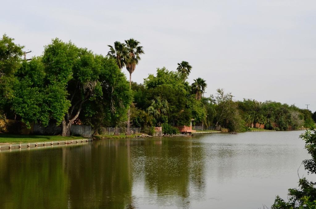
1 The Late Quaternary Rio Grande Delta A Distinctive, Underappreciated Geologic System Thomas E. Ewing 1 and Juan L. Gonzalez 2 1 Frontera Exploration Consultants, Redland Rd., Ste. 250, San Antonio, Texas Department of Multidisciplinary Sciences, University of Texas Rio Grande Valley, 1201 W. University Dr., Edinburg, Texas GCAGS Explore & Discover Article #00013 * Posted September 13, * Abstract extracted from a full paper published in the GCAGS Transactions (see footnote reference below), which is available as part of the entire 2016 GCAGS Transactions volume via the GCAGS Bookstore at the Bureau of Economic Geology ( or as an individual document via AAPG Datapages, Inc. ( and delivered as an oral presentation at the 66th Annual GCAGS Convention and 63rd Annual GCSSEPM Meeting in Corpus Christi, Texas, September 18 20, ABSTRACT The delta of the Rio Grande/Rio Bravo in southernmost Texas and northern Tamaulipas is one of the major deltas of North America. Over 600,000 people live on the Holocene delta and river plain, and a million more on its Pleistocene ancestors, yet geologic knowledge is limited. Combining available geologic information with global satellite photography gives a balanced view of an important delta. The Holocene delta begins at a point west of San Benito, Texas, forming a classic eastward-opening delta. Over half of the delta lies south of the present Rio Grande drainage. The delta passes westward into a floodplain that becomes entrenched into older rocks westward to Roma. In this delta, distributary channels or resacas are extremely sinuous and show a pronounced levee rise. A yazoo stream in the floodplain cuts northward across Pleistocene deposits to form a displaced delta. The delta plain is extensively modified by eolian processes. Erosion of clay-rich algal mats from exposed esteros (large, shallow ephemeral lakes) create complex clay dune deposits that form 6 m (20 ft) high hills (lomitas) on the flat plain. Dominant SE to SSE winds affect sand movement along the transgressive shorelines. Longshore movement is particularly effective on the north side of the delta, less so on the south side. The delta appears to have formed between 8000 and 3000 years BP by a robust, sediment-loaded Rio Grande. This period occurs during the Holocene Climatic Optimum, which was a dry time (altithermal) on the High Plains. Since 3000 years BP, the delta has been much less active and has been transgressed by barrier systems. The delta today is inactive, because of upstream reservoirs built since the 1940s. Before then, the river had irregular high discharge due to tropical systems and contributions from the upper Rio Grande system. The Pleistocene deltas that form the Beaumont surface underlying McAllen, Edinburg, and Harlingen probably exhibit similar landforms. Originally published as: Ewing, T. E., and J. L. Gonzalez, 2016, The late Quaternary Rio Grande Delta A distinctive, underappreciated geologic system: Gulf Coast Association of Geological Societies Transactions, v. 66, p
2 THE LATE QUATERNARY RIO GRANDE DELTA : A Distinctive, Underappreciated Geologic System Thomas E. Ewing tewing@fronteraexploration.com Juan Gonzalez juan.l.gonzalez@utrgv.edu 2016 GCAGS Corpus Christi, TX
3 ABSTRACT The delta of the Rio Grande/Rio Bravo in southernmost Texas and northern Tamaulipas is one of the major deltas of North America. Over 600,000 people live on the Holocene delta and river plain, and a million more on its Pleistocene ancestors, yet geologic knowledge is limited. Combining available geologic information with global satellite photography gives a balanced view of an important delta. The Holocene delta begins at a point west of San Benito, Texas, forming a classic eastward-opening delta. Over half of the delta lies south of the present Rio Grande drainage. The delta passes westward into a floodplain that becomes entrenched into older rocks westward to Roma. In this delta, distributary channels or resacas are extremely sinuous and show a pronounced levee rise. A yazoo stream in the floodplain cuts northward across Pleistocene deposits to form a displaced delta. The delta plain is extensively modified by eolian processes. Erosion of clay-rich algal mats from exposed esteros create complex "clay dune" deposits that form 6 m (20-ft) high hills (lomitas) on the flat plain. Dominant SE to SSE winds affect sand movement along the transgressive shorelines. Longshore movement is particularly effective on the north side of the delta, less so on the south side. The delta appears to have formed between 8,000 and 3,000 years BP by a robust, sediment-loaded Rio Grande. This period occurs during the Holocene Climatic Optimum, which was a dry time (Altithermal) on the High Plains. Since 3,000 years BP, the delta has been much less active and has been transgressed by barrier systems. The delta today is inactive, because of upstream reservoirs built since the 1940s. Before then, the river had irregular high discharge due to tropical systems and contributions from the upper Rio Grande system. The Pleistocene deltas that form the Beaumont surface underlying McAllen, Edinburg and Harlingen probably exhibit similar landforms.
4 SUMMARY Major point-source delta in western Gulf (Late Pleistocene and Holocene) Densely settled (1-2 million people) but geologic knowledge is sparse River and valley subject to great floods, but otherwise area is semiarid Consistent SSE winds in semiarid climate generate distinctive features; lomitas (clay dunes), mudflats Transgressive shoreline system highly variable


5 Texas Gulf Coast Shorelines (From Ewing, 2016, Texas Through Time; UT Bur. Econ. Geol.)

6 Rio Grande Basin 456,000 km 3 contributing Major water sources to north, west, southwest

")
7 Field Trip Stops (planned)


8 RELATION TO LGM LOWSTAND??
 and")
9 Rainfall (in/yr) and Winds
 rainfall 8-14")
 at Rio")

10 Hurricane Beulah storm of record Hit valley in Sept (to 75 cm) rainfall 8-14 storm surge Pt Isabel and N Created river flood of 6230 m 3 /s (220,000 cfs) at Rio Grande City with dams in place! $100 million damage in US alone (prob. $5-15 billion today)


11 Delta Overview

12 Resacas and Lakes

13 Major Resacas (US Side)

14 Sinuous Channels, Upper Delta Sinuosity = 2.68 MB Width = km M Wavelength =1.6 km M Arc Height = 515 m MB Height = 3-5m Channel Width: Today 33m Historic m

15 Outer delta closeup

16 Lomitas and Esteros


17 Algal mats and clay dunes

18 Lake with dune filling R. La Pita

19 R. Cuates cut-through by lake


20 Boca Chica Dunes and Boca del Rio


21 Profiles of bay and barrier
22 Irrigation and Flood Control


23 Dams and Canals


24 Sunset, Sal del Rey
Sedimentology, Petrography, and Mineralogy of the Tallahatta Formation near the City of Meridian, Mississippi
 Sedimentology, Petrography, and Mineralogy of the Tallahatta Formation near the City of Meridian, Mississippi Kiana McFadden and Ezat Heydari Department of Physics, Atmospheric Sciences, and Geoscience,
Sedimentation Dynamics and Stratigraphy of the Middle Breton Sound Estuary, Southeastern Louisiana: Spatiotemporal Evidence for Subdeltaic Evolution
 Sedimentation Dynamics and Stratigraphy of the Middle Breton Sound Estuary, Southeastern Louisiana: Spatiotemporal Evidence for Subdeltaic Evolution Edwin J. Bomer IV 1, Samuel J. Bentley 1,2, Kehui Xu
Facies Reconstruction of a Late Pleistocene Cypress Forest Discovered on the Northern Gulf of Mexico Continental Shelf
 Facies Reconstruction of a Late Pleistocene Cypress Forest Discovered on the Northern Gulf of Mexico Continental Shelf Suyapa Gonzalez 1, Samuel J. Bentley, Sr. 1, Kristine L. DeLong 3, Kehui Xu 2, Jeffrey
Developed in Consultation with Florida Educators
 Developed in Consultation with Florida Educators Table of Contents Next Generation Sunshine State Standards Correlation Chart... 7 Benchmarks Chapter 1 The Practice of Science...................... 11
Changes in Texas Ecoregions Copy the questions and answers
 Changes in Texas Ecoregions Copy the questions and answers 1. What are some kinds of damage that hurricanes cause? Roads and bridges might be washed away. Trees and power lines can be knocked down. Area
Osareni C. Ogiesoba and Angela K. Eluwa. Bureau of Economic Geology, University of Texas at Austin, Burnet Rd., Austin Texas 78759
 Structural Styles of Eocene Jackson and Oligocene Vicksburg Formations within the Rio Grande and Houston Embayments near the San Marcos Arch, Refugio and Calhoun Counties, South Texas Gulf Coast Osareni
GEOL 1121 Earth Processes and Environments
 GEOL 1121 Earth Processes and Environments Wondwosen Seyoum Department of Geology University of Georgia e-mail: seyoum@uga.edu G/G Bldg., Rm. No. 122 Seyoum, 2015 Chapter 6 Streams and Flooding Seyoum,
Laboratory Exercise #3 The Hydrologic Cycle and Running Water Processes
 Laboratory Exercise #3 The Hydrologic Cycle and Running Water Processes page - 1 Section A - The Hydrologic Cycle Figure 1 illustrates the hydrologic cycle which quantifies how water is cycled throughout
Earth Science Chapter 6 Section 2 Review
 Name: Class: Date: Earth Science Chapter 6 Section Review Multiple Choice Identify the choice that best completes the statement or answers the question. 1. Most streams carry the largest part of their
Final Exam. Running Water Erosion and Deposition. Willamette Discharge. Running Water
 Final Exam Running Water Erosion and Deposition Earth Science Chapter 5 Pages 120-135 Scheduled for 8 AM, March 21, 2006 Bring A scantron form A calculator Your 3 x 5 paper card of formulas Review questions
Figure 1. Which part of the river is labelled in Figure 1? a) Mouth b) Source c) Lower course d) channel
 Mouth b) Source c) Lower course d) channel") Rivers 1. Study Figure 1 showing the long profile of a river Figure 1 A Which part of the river is labelled in Figure 1? a) Mouth b) Source c) Lower course d) channel (1 mark) 2. Complete the sentences
Rivers 1. Study Figure 1 showing the long profile of a river Figure 1 A Which part of the river is labelled in Figure 1? a) Mouth b) Source c) Lower course d) channel (1 mark) 2. Complete the sentences
MISSISSIPPI RIVER DELTA OVERVIEW
 MISSISSIPPI RIVER DELTA OVERVIEW Science and Engineering Special Team Conference Louisiana State University October 9, 2012 Introduction Basics of the Mississippi Delta Natural and Human-Induced Land Loss
Earth processes are dynamic actions that occur both on
 29 Weathering, Erosion, and Deposition R EA D I N G Earth processes are dynamic actions that occur both on the earth s surface and inside the earth. Any process that breaks down earth material, such as
4. The map below shows a meandering stream. Points A, B, C, and D represent locations along the stream bottom.
 1. Sediment is deposited as a river enters a lake because the A) velocity of the river decreases B) force of gravity decreases C) volume of water increases D) slope of the river increases 2. Which diagram
STREAM SYSTEMS and FLOODS
 STREAM SYSTEMS and FLOODS The Hydrologic Cycle Precipitation Evaporation Infiltration Runoff Transpiration Earth s Water and the Hydrologic Cycle The Hydrologic Cycle The Hydrologic Cycle Oceans not filling
Precipitation Evaporation Infiltration Earth s Water and the Hydrologic Cycle. Runoff Transpiration
 STREAM SYSTEMS and FLOODS The Hydrologic Cycle Precipitation Evaporation Infiltration Earth s Water and the Hydrologic Cycle Runoff Transpiration The Hydrologic Cycle The Hydrologic Cycle Oceans not filling
Stream Geomorphology. Leslie A. Morrissey UVM July 25, 2012
 Stream Geomorphology Leslie A. Morrissey UVM July 25, 2012 What Functions do Healthy Streams Provide? Flood mitigation Water supply Water quality Sediment storage and transport Habitat Recreation Transportation
Term Knowledge Using and applying Grade Criteria Autumn 1 Assessment window October Natural hazards pose major risks to people and property.
 Assessment Schedule Year 9 2015/6 Term Knowledge Using and applying Grade Criteria Autumn 1 Assessment window October 2015 3.1.1.2 Tectonic Natural hazards pose major risks to people and property. Definition
Source Body Migration, an Approximate Inversion Method for Full Tensor Gravity Gradiometer Data
 Source Body Migration, an Approximate Inversion Method for Full Tensor Gravity Gradiometer Data James Brewster, Alan Morgan, and John Mims * Bell Geospace Inc., 400 N. Sam Houston Pkwy E., Ste. 325, Houston,
Laboratory Exercise #4 Geologic Surface Processes in Dry Lands
 Page - 1 Laboratory Exercise #4 Geologic Surface Processes in Dry Lands Section A Overview of Lands with Dry Climates The definition of a dry climate is tied to an understanding of the hydrologic cycle
The Coast: Beaches and Shoreline Processes
 1 2 3 4 5 6 7 8 9 The Coast: es and Shoreline Processes Trujillo & Thurman, Chapter 10 Oceanography 101 Chapter Objectives Recognize the various landforms characteristic of beaches and coastal regions.
The Coast: Beaches and Shoreline Processes Trujillo & Thurman, Chapter 10
 The Coast: es and Shoreline Processes Trujillo & Thurman, Chapter 10 Oceanography 101 Chapter Objectives Recognize the various landforms characteristic of beaches and coastal regions. Identify seasonal
27. Running Water I (p ; )
") 27. Running Water I (p. 424-436; 440-444) Hydrosphere How much of the Earth s surface is covered by water? Earth's water is collectively called the and is stored in a number of so-called as follows: 1.
27. Running Water I (p. 424-436; 440-444) Hydrosphere How much of the Earth s surface is covered by water? Earth's water is collectively called the and is stored in a number of so-called as follows: 1.
Physical landscapes River landscapes in the UK
 Physical landscapes River landscapes in the UK The shape of river valleys change s as rivers flow downstream - PROCESSES Erosion Abrasion or corrasion Attrition Hydraulic Action Solution or corrosion Deposition
Quick-Look Deterministic Approach for Evaluating Shale Distribution in Sandstone Reservoirs: Progress Report
 Quick-Look Deterministic Approach for Evaluating Shale Distribution in Sandstone Reservoirs: Progress Report James J. Willis 1,2, Duncan S. McIntosh, Jr. 3, Gregory J. Ferguson 3, Jesse W. Zwennes 3, James
ES 105 Surface Processes I. Hydrologic cycle A. Distribution % in oceans 2. >3% surface water a. +99% surface water in glaciers b.
 ES 105 Surface Processes I. Hydrologic cycle A. Distribution 1. +97% in oceans 2. >3% surface water a. +99% surface water in glaciers b. >1/3% liquid, fresh water in streams and lakes~1/10,000 of water
Structural Styles and Geotectonic Elements in Northwestern Mississippi: Interpreted from Gravity, Magnetic, and Proprietary 2D Seismic Data
 Structural Styles and Geotectonic Elements in Northwestern Mississippi: Interpreted from Gravity, Magnetic, and Proprietary 2D Seismic Data Nick Loundagin 1 and Gary L. Kinsland 2 1 6573 W. Euclid Pl.,
Erosion and Deposition
 CHAPTER 3 LESSON 2 Erosion and Deposition Landforms Shaped by Water and Wind Key Concepts What are the stages of stream development? How do water erosion and deposition change Earth s surface? How do wind
Page 1. Name:
 Name: 1) Which event is the best example of erosion? dissolving of rock particles on a limestone gravestone by acid rain breaking apart of shale as a result of water freezing in a crack rolling of a pebble
Lab 12 Coastal Geology
 Lab 12 Coastal Geology I. Fluvial Systems Hydrologic Cycle Runoff that flows into rivers = precipitation (rain and snowmelt) [infiltration (loss to groundwater) + evaporation (loss to atmosphere) + transpiration
 Page 1 of 9 Name: Base your answer to the question on the diagram below. The arrows show the direction in which sediment is being transported along the shoreline. A barrier beach has formed, creating a
Weathering and Erosion
 Have you ever looked at the land around you and wondered how it was shaped? The geologic features that help define the world are still being shaped by the natural processes of weathering, erosion, and
Name period date assigned date due date returned. Texas Ecoregions
 Name period date assigned date due date returned Directions: Go to the following website: https://www-k6.thinkcentral.com/epc/start.do Use the log in that is taped to the top of your laptop. If you are
Summary. Streams and Drainage Systems
 Streams and Drainage Systems Summary Streams are part of the hydrologic cycle and the chief means by which water returns from the land to the sea. They help shape the Earth s surface and transport sediment
Year 6. Geography. Revision
 Year 6 Geography Revision November 2017 Rivers and World knowledge How the water cycle works and the meaning of the terms evaporation, condensation, precipitation, transpiration, surface run-off, groundwater
The Geology of Sebago Lake State Park
 Maine Geologic Facts and Localities September, 2002 43 55 17.46 N, 70 34 13.07 W Text by Robert Johnston, Department of Agriculture, Conservation & Forestry 1 Map by Robert Johnston Introduction Sebago
Name. 4. The diagram below shows a soil profile formed in an area of granite bedrock. Four different soil horizons, A, B, C, and D, are shown.
 Name 1. In the cross section of the hill shown below, which rock units are probably most resistant to weathering? 4. The diagram below shows a soil profile formed in an area of granite bedrock. Four different
What is weathering and how does it change Earth s surface? Answer the question using
 7 th Grade Lesson What is weathering and how does it change Earth s surface? Answer the question using the sentence frame. You have 4 minutes. Weathering is. This changes the Earth s surface because. 1
Geologic Trips San Francisco and the Bay Area
 Excerpt from Geologic Trips San Francisco and the Bay Area by Ted Konigsmark ISBN 0-9661316-4-9 GeoPress All rights reserved. No part of this book may be reproduced without written permission in writing,
CASE STUDY #9 - Brushy Fork Dam, Sugar Grove, West Virginia
 CASE STUDY #9 - Brushy Fork Dam, Sugar Grove, West Virginia Brushy Fork Dam is a flood control structure built by the Soil Conservation Service southeast of the city of Franklin in Pendleton County, West
The Effect of Weather, Erosion, and Deposition in Texas Ecoregions
 The Effect of Weather, Erosion, and Deposition in Texas Ecoregions 7.8B: I can analyze the effects of weathering, erosion, and deposition on the environment in ecoregions of Texas Weathering The breakdown
Name Roy G Biv Page 1
 Name Roy G Biv Base your answers to questions 1 through 3 on the diagram below. The arrows show the direction in which sediment is being transported along the shoreline. A barrier beach has formed, creating
Environmental Science Institute The University of Texas - Austin
 Environmental Science Institute The University of Texas - Austin Geologic Wonders of Central Texas Dr. Leon Long This file contains suggestions for how to incorporate the material from this CDROM into
WATER ON AND UNDER GROUND. Objectives. The Hydrologic Cycle
 WATER ON AND UNDER GROUND Objectives Define and describe the hydrologic cycle. Identify the basic characteristics of streams. Define drainage basin. Describe how floods occur and what factors may make
Earth Science Chapter 9. Day 6 - Finish Capillary Action Lab - Quiz over Notes - Review Worksheets over Sections 9.2 and 9.3
 Earth Science Chapter 9 Day 1 Day 2 Day 3 Read Section 9.1 Surface Water Chapter 9 Term Sheet Notes over Section 9.1 Surface Water Section 9.1 Review Worksheets Quiz over Section 9.1 Notes Virtual Lab
Streams. Stream Water Flow
 CHAPTER 14 OUTLINE Streams: Transport to the Oceans Does not contain complete lecture notes. To be used to help organize lecture notes and home/test studies. Streams Streams are the major geological agents
ΛTKINS. Applications of Regional Sediment Management Concepts in Texas Estuarine Restoration Projects. Riparian Workshop Fort Worth, October 17, 2012
 Juan C Moya, PhD., PG Coastal Planning and Restoration Applications of Regional Sediment Management Concepts in Texas Estuarine Restoration Projects Riparian Workshop Fort Worth, October 17, 2012 West
10/27/2014. Surface Processes. Surface Processes. Surface Processes. Surface Processes. Surface Processes
 Hewitt/Lyons/Suchocki/Yeh Conceptual Integrated Science Chapter 25 Surface or surficial processes originate at Earth's surface and reshape its contours. Surface processes include: Weathering Erosion Deposition
Influence of the Major Drainages to the Mississippi River and Implications for System Level Management
 Influence of the Major Drainages to the Mississippi River and Implications for System Level Management Brian M. Vosburg Geologist Louisiana Coastal Protection and Restoration Authority brian.vosburg@la.gov
Map Mysteries Activities
 Page 1 of 8 Map Mysteries Activities 74,796 Ready-To-Go Lesson Plans Teaching Earth Science and Geography with USGS Topographic and Thematic Maps Author: Dr. Joseph J. Kerski Geographer Box 25046 - MS
Controlling Processes That Change Land
 1 Name Date Controlling Processes That Change Land People try to control some of the processes that change land. To do this, people apply technology- the use of science to solve problems in everyday life.
Which map shows the stream drainage pattern that most likely formed on the surface of this volcano? A) B)
 B)") 1. When snow cover on the land melts, the water will most likely become surface runoff if the land surface is A) frozen B) porous C) grass covered D) unconsolidated gravel Base your answers to questions
1. When snow cover on the land melts, the water will most likely become surface runoff if the land surface is A) frozen B) porous C) grass covered D) unconsolidated gravel Base your answers to questions
New GCSE Geography AQA
 Learning Checklist Half Term 1 26 th September 3 rd October 10 th October 17 th October 1.1.1 Tectonic Hazards Plate tectonics theory. Global distribution of earthquakes and volcanic eruptions and their
Evolution of the Po Delta, Italy
 Evolution of the Po Delta, Italy Albert Kettner & James Syvitski, Charles Vörösmarty Dynamics and Vulnerability of River Delta Systems workshop September, 2007 Outline 21,000 years ago Effects of the ever
Cattaraugus Creek: A Story of Flowing Water and the Geology of the Channel It Flows Through Presentation to West Valley Citizen Task Force 4/27/16
 Cattaraugus Creek: A Story of Flowing Water and the Geology of the Channel It Flows Through Presentation to West Valley Citizen Task Force 4/27/16 Raymond C. Vaughan, Ph.D. What happens if you drop a
Sediment Deposition LET THE RIVER RUN T E A C H E R. Activity Overview. Activity at a Glance. Time Required. Level of Complexity.
 Activity at a Glance Grade: 6 9 Subject: Science Category: Physical Science, Earth Science Topic: Deposition, River Systems Time Required Two 45-minute periods Level of Complexity Medium Materials* TI-73
mountain rivers fixed channel boundaries (bedrock banks and bed) high transport capacity low storage input output
 high transport capacity low storage input output") mountain rivers fixed channel boundaries (bedrock banks and bed) high transport capacity low storage input output strong interaction between streams & hillslopes Sediment Budgets for Mountain Rivers Little
mountain rivers fixed channel boundaries (bedrock banks and bed) high transport capacity low storage input output strong interaction between streams & hillslopes Sediment Budgets for Mountain Rivers Little
What are the different ways rocks can be weathered?
 Romano - 223 What are the different ways rocks can be weathered? Weathering - the breakdown of rocks and minerals at the Earth s surface 1. 2. PHYSICAL WEATHERING Rock is broken into smaller pieces with
EROSION AND DEPOSITION
 CHAPTER 8 EROSION AND DEPOSITION SECTION 8 1 Changing Earth s Surface (pages 252-255) This section explains how sediment is carried away and deposited elsewhere to wear down and build up Earth s surface.
Name: Which rock layers appear to be most resistant to weathering? A) A, C, and E B) B and D
 A, C, and E B) B and D") Name: 1) The formation of soil is primarily the result of A) stream deposition and runoff B) precipitation and wind erosion C) stream erosion and mass movement D) weathering and biological activity 2)
Name: 1) The formation of soil is primarily the result of A) stream deposition and runoff B) precipitation and wind erosion C) stream erosion and mass movement D) weathering and biological activity 2)
Ecological Context - Urban settlements are part of their surrounding ecosystem. Austin
 Ecological Context - Urban settlements are part of their surrounding ecosystem Austin Ecotone Division between West and East Flyway Uplift River Balcones Escarpment Central Texas Climate The principal
Floods Lecture #21 20
 Floods 20 Lecture #21 What Is a Flood? Def: high discharge event along a river! Due to heavy rain or snow-melt During a flood, a river:! Erodes channel o Deeper & wider! Overflows channel o Deposits sediment
In the space provided, write the letter of the description that best matches the term or phrase. a. any form of water that falls to Earth s
 Skills Worksheet Concept Review In the space provided, write the letter of the description that best matches the term or phrase. 1. condensation 2. floodplain 3. watershed 4. tributary 5. evapotranspiration
Terrain Units PALEOGEOGRAPHY: LANDFORM CREATION. Present Geology of NYS. Detailed Geologic Map of NYS
 NYS TOPOGRAPHY Why so? PALEOGEOGRAPHY: LANDFORM CREATION Prof. Anthony Grande AFG 014 Present Geology of NYS Detailed Geologic Map of NYS Generalized Geology Detailed Geology Hot links to the fold out
netw rks Guided Reading Activity Essential Question: How does geography influence the way people live? Earth's Physical Geography
 Guided Reading Activity Lesson 1 Earth and the Sun Essential Question: How does geography influence the way people live? Looking at Earth Directions: What are the layers that make up Earth? Use your textbook
West Galveston Bay Regional Sediment Management Plan (An Eco-geomorphologic Approach)
") West Galveston Bay Regional Sediment Management Plan (An Eco-geomorphologic Approach) Juan Moya, Matthew Mahoney and Mike Smith Restore America s Estuaries Conference Tampa, FL, October 23, 2012 Atkins
West Galveston Bay Regional Sediment Management Plan (An Eco-geomorphologic Approach) Juan Moya, Matthew Mahoney and Mike Smith Restore America s Estuaries Conference Tampa, FL, October 23, 2012 Atkins
3/3/2013. The hydro cycle water returns from the sea. All "toilet to tap." Introduction to Environmental Geology, 5e
 Introduction to Environmental Geology, 5e Running Water: summary in haiku form Edward A. Keller Chapter 9 Rivers and Flooding Lecture Presentation prepared by X. Mara Chen, Salisbury University The hydro
Paper presented in the Annual Meeting of Association of American Geographers, Las Vegas, USA, March 2009 ABSTRACT
 Paper presented in the Annual Meeting of Association of American Geographers, Las Vegas, USA, March 2009 ABSTRACT CHANGING GEOMORPHOLOGY OF THE KOSI RIVER SYSTEM IN THE INDIAN SUBCONTINENT Nupur Bose,
Rivers and Streams. Streams. Hydrologic Cycle. Drainage Basins and Divides. Colorado River Drainage Basin. Colorado Drainage Basins.
 Chapter 14 Hydrologic Cycle Rivers and Streams Streams A stream is a body of water that is confined in a channel and moves downhill under the influence of gravity. This definition includes all sizes of
Changes to Land 5.7B. landforms: features on the surface of Earth such as mountains, hills, dunes, oceans and rivers
 All the landforms on Earth have changed over time and continue to change. Many of the changes were caused by wind, moving water, and moving ice. Mountains have grown and shrunk. Rivers have cut away land
Which particle of quartz shows evidence of being transported the farthest distance by the stream? A) B) C) D)
 B) C) D)") 1. Base your answer to the following question on the block diagram below, which represents the landscape features associated with a meandering stream. WX is the location of a cross section. Location A
1. Base your answer to the following question on the block diagram below, which represents the landscape features associated with a meandering stream. WX is the location of a cross section. Location A
Diagnostic Geomorphic Methods for Understanding Future Behavior of Lake Superior Streams What Have We Learned in Two Decades?
 Diagnostic Geomorphic Methods for Understanding Future Behavior of Lake Superior Streams What Have We Learned in Two Decades? Faith Fitzpatrick USGS WI Water Science Center, Middleton, WI fafitzpa@usgs.gov
Think about the landforms where you live. How do you think they have changed over time? How do you think they will change in the future?
 reflect All the landforms on Earth have changed over time and continue to change. Many of the changes were caused by wind, moving water, and moving ice. Mountains have grown and shrunk. Rivers have cut
Streams. Water. Hydrologic Cycle. Geol 104: Streams
 Streams Why study streams? Running water is the most important geologic agent in erosion, transportation and deposition of sediments. Water The unique physical and chemical properties of water make it
Chapter 21 Southwest Asia: Harsh & Arid Lands
 Name Hour Chapter 21 Southwest Asia: Harsh & Arid Lands Essential Question: How has the physical geography of Asia influenced the development of these regions (i.e. history, population distribution, &
Shallow Karst Aquifer System of the Lake Belt Study Area, Miami-Dade County, Florida, USA EXTENDED ABSTRACT
 Second International Conference on Saltwater Intrusion and Coastal Aquifers Monitoring, Modeling, and Management. Merida, Mexico, March 30 April 2, 2003 Shallow Karst Aquifer System of the Lake Belt Study
Natural hazards in Glenorchy Summary Report May 2010
 Natural hazards in Glenorchy Summary Report May 2010 Contents Glenorchy s hazardscape Environment setting Flood hazard Earthquakes and seismic hazards Hazards Mass movement Summary Glossary Introduction
2. What type of rocks would you expect in this area, based on the topography? What is your reasoning?
 Geology 101 Bonus Lab Name Topographic maps are useful in helping us interpret the history of the landscape of an area. The questions below are designed to help you learn to interpret topographic maps.
Sequence Stratigraphy of the Upper Cretaceous Niobrara Formation, A Bench, Wattenberg Field, Denver Julesburg Basin, Colorado*
 Sequence Stratigraphy of the Upper Cretaceous Niobrara Formation, A Bench, Wattenberg Field, Denver Julesburg Basin, Colorado* Lisa E. Remington LaChance 1 and Mark C. Robinson 1 Search and Discovery Article
Landscape evolution. An Anthropic landscape is the landscape modified by humans for their activities and life
 Landforms Landscape evolution A Natural landscape is the original landscape that exists before it is acted upon by human culture. An Anthropic landscape is the landscape modified by humans for their activities
Glacial landscape. Arid Landscape. Geological feature. Extreme drainage. In this location you should find the following features:
 Glacial landscape In this location you should find the following features: Alluvial fan Braided river End moraines Glacial niche Talus cone U-valley Try to determine the altitude of the tree limit in the
Weathering, Erosion, and Deposition Guided Notes
 1. Weathering, Erosion, and Deposition 2. Outline Section 1: Weathering Section 2: Erosion Section 3: Deposition Section 4: Case Study Weathering, Erosion, and Deposition Guided Notes 3. Section 1: Weathering
Kristy Milliken, Rice University
 2005 GCSSEPM Foundation Ed Picou Fellowship Grant for Graduate Studies in the Earth Sciences Recipient Kristy Milliken, Rice University Controls on the Transgressive facies of coastal plain incised valley
1. Base your answer to the following question on the map below, which shows the generalized bedrock of a part of western New York State.
 1. Base your answer to the following question on the map below, which shows the generalized bedrock of a part of western New York State. 3. The table below describes the deposits that an observer saw while
Name period date assigned date due date returned. Texas Ecoregions
 Name period date assigned date due date returned Directions: Go to the following website: https://www-k6.thinkcentral.com/epc/start.do Use the log in that is taped to the top of your laptop. If you are
Geol 117 Lecture 18 Beaches & Coastlines. I. Types of Coastlines A. Definition:
 I. Types of Coastlines A. Definition: 1. Shore = narrow zone where ocean meets land (e.g. beach) 2. Coast is a broad area where both ocean and land processes act a. Includes onshore marshes, dunes, sea
water erosion lithosphere Describe the process of erosion and deposition. chemical weathering Dissolving limestone is an example of.
 At one time, there was one large island off the coast of Mississippi and now it is two separate islands. What caused the island to be split into two? water erosion The crust and the top part of the upper
Ch 10 Deposition Practice Questions
 1. Base your answer to the following question on the data table below. Six identical cylinders, A through F, were filled with equal volumes of sorted spherical particles. The data table shows the particle
Science EOG Review: Landforms
 Mathematician Science EOG Review: Landforms Vocabulary Definition Term canyon deep, large, V- shaped valley formed by a river over millions of years of erosion; sometimes called gorges (example: Linville
Chapter 2 Planet Earth
 Chapter 2 Planet Earth Section Notes Earth and the Sun s Energy Water on Earth The Land Close-up The Water Cycle World Almanac Major Eruptions in the Ring of Fire Quick Facts Chapter 2 Visual Summary Video
Continental Landscapes
 Continental Landscapes Landscape influenced by tectonics, climate & differential weathering Most landforms developed within the last 2 million years System moves toward an equilibrium Continental Landscapes
GEOLOGIC MAPS AND GEOLOGIC STRUCTURES A TEXAS EXAMPLE
 GEOLOGIC MAPS AND GEOLOGIC STRUCTURES A TEXAS EXAMPLE Roger Steinberg Assistant Professor of Geology Del Mar College 101 Baldwin Corpus Christi, TX 78404 361-698-1665 rsteinb@delmar.edu For the maps accompanying
Depositional Environment
 Depositional Environment Sedimentary depositional environment describes the combination of physical, chemical and biological processes associated with the deposition of a particular type of sediment. Types
Geography Exams. RAG rate The Challenge of Natural Hazards
 Geography Exams You will sit three papers, Paper 1 will last 1 hour 30 minutes and will examine your understanding of The Challenge of Natural Hazards, The Living World and Physical Landscapes in the UK.
NATURAL RIVER. Karima Attia Nile Research Institute
 NATURAL RIVER CHARACTERISTICS Karima Attia Nile Research Institute NATURAL RIVER DEFINITION NATURAL RIVER DEFINITION Is natural stream of water that flows in channels with ih more or less defined banks.
Running Water Earth - Chapter 16 Stan Hatfield Southwestern Illinois College
 Running Water Earth - Chapter 16 Stan Hatfield Southwestern Illinois College Hydrologic Cycle The hydrologic cycle is a summary of the circulation of Earth s water supply. Processes involved in the hydrologic
Description DESCRIPTION
 DESCRIPTION The location of the Upper James Watershed is located in northeastern South Dakota as well as southeastern North Dakota. It includes the following counties located in North Dakota Barnes, Dickey,
M14/3/GEOGR/SP2/ENG/TZ0/XX/Q GEOGRAPHY STANDARD LEVEL PAPER 2. Monday 19 May 2014 (morning) 1 hour 20 minutes INSTRUCTIONS TO CANDIDATES
 1 hour 20 minutes INSTRUCTIONS TO CANDIDATES") M14/3/GEOGR/SP2/ENG/TZ0/XX/Q 22145203 GEOGRAPHY STANDARD LEVEL PAPER 2 Monday 19 May 2014 (morning) 1 hour 20 minutes INSTRUCTIONS TO CANDIDATES Do not open this examination paper until instructed to do
M14/3/GEOGR/SP2/ENG/TZ0/XX/Q 22145203 GEOGRAPHY STANDARD LEVEL PAPER 2 Monday 19 May 2014 (morning) 1 hour 20 minutes INSTRUCTIONS TO CANDIDATES Do not open this examination paper until instructed to do
Unit 3 Review - Surface Processes
 Unit 3 Review - Surface Processes 1. Why is the surface of Mercury covered with meteor impact craters, while Earth s surface has relatively few craters? A) Mercury is larger than Earth, so it gets hit
Technical Memorandum No
 Pajaro River Watershed Study in association with Technical Memorandum No. 1.2.10 Task: Evaluation of Four Watershed Conditions - Sediment To: PRWFPA Staff Working Group Prepared by: Gregory Morris and