NUCLEAR POWER PLANT SITE SELECTION
|
|
|
- Gerard Byrd
- 5 years ago
- Views:
Transcription
1 NUCLEAR POWER PLANT SITE SELECTION ABDELATY B. SALMAN Ex-Chairman Nuclear Materials Authority, Cairo, Egypt
2 I. Introduction The aim of this article is to present the requirements and characteristics for the nuclear power plant site selection. It will focus on the treatments of the main geologic and tectonic features and the nature of the site. Sitting factors and criteria are important in assuring that radiological doses from normal operation and postulated accidents will be acceptably low.
3 Factors to be considered when evaluating sites
4 (a) Characteristics of reactor design and proposed operation including: (1) Intended use of the reactor including the proposed maximum power level and the nature and inventory of contained radioactive materials; (2) The extent to which generally accepted engineering standards are applied to the design of the reactor; (3) The extent to which the reactor incorporates unique or unusual features having a significant bearing on the probability or consequences of accidental release of radioactive materials; (4) The safety features that are to be engineered into the facility and those barriers that must be breached as a result of an accident before a release of radioactive material to the environment can occur.
5 (b) Population density and use characteristics of the site environs, including the exclusion area, low population zone, and population center distance. Exclusion area Area surrounding the reactor, in which the reactor licensee has the authority to determine all activities including exclusion or removal of personnel and property from the area Low population zone Area immediately surrounding the exclusion area which contains residents, the total number and density of which are such that there is a reasonable probability that appropriate protective measures could be taken in their behalf in the event of a serious accident. Population center distance The distance from the reactor to the nearest boundary of a densely populated center ( 25,000 residents).
6 (c) Physical characteristics for site; seismology, meteorology, geology & hydrology (1) Seismic and Geologic Sitting Criteria for Nuclear Power Plants," describes the nature of investigations required to obtain the geologic and seismic data necessary to determine site suitability and to provide reasonable assurance that a nuclear power plant can be constructed and operated at a proposed site without undue risk to the health and safety of the public. It describes procedures for determining the quantitative vibratory ground motion design basis at a site due to earthquakes and describes information needed to determine whether and to what extent a nuclear power plant need be designed to withstand the effects of surface faulting.
7 (2) Meteorological conditions at the site and in the surrounding area should be considered. (3) Geological and hydrological character- istics of the proposed site may have a bearing on the consequences of an escape of radioactive material from the facility. Special precautions should be planned if a reactor is to be located at a site where a significant quantity of radioactive effluent might accidentally flow into nearby streams or rivers or might find ready
8 (d) Where unfavorable physical characteristics of the site exist, the proposed site may nevertheless be found to be acceptable if the design of the facility includes appropriate and adequate compensating engineering safeguards.
9 Geologic and seismic sitting criteria. (c) Geological, seismological, and engineering characteristics The geological, seismological, and engineering characteristics of a site and its environs must be investigated in sufficient scope and detail to permit an adequate evaluation of the proposed site, to provide sufficient information to support evaluations performed to arrive at estimates of the Safe Shutdown Earthquake Ground Motion, and to permit adequate engineering solutions to actual or potential geologic and seismic effects at the proposed site
10 The following points should be studied; *vibratory ground motion, *tectonic surface deformation, *non-tectonic deformation, *earthquake recurrence rates, *fault geometry and slip rates, *site foundation materials, and *seismically induced floods and water waves
11 (d) Geologic and seismic sitting factors. The geologic and seismic sitting factors considered for design must include a determination of the Safe Shutdown Earthquake Ground Motion for the site, the potential for surface tectonic and non- tectonic deformations, the design bases for seismically induced floods and water waves.
12 (1)Determination of the Safe Shutdown Earthquake Ground Motion. The Safe Shutdown Earthquake Ground Motion for the site is characterized by both horizontal and vertical free-field field ground motion response spectra at the free ground surface. Uncertainties are inherent in such estimates. These uncertainties must be addressed through an appropriate analysis, such as a probabilistic seismic hazard analysis or suitable sensitivity analyses.
13 (2) Determination of the potential for surface tectonic and nontectonic deformations. Sufficient geological, seismological, and geophysical data must be provided to clearly establish whether there is a potential for surface deformation. (3) Determination of design bases for seismically induced floods and water waves. The size of seismically induced floods and water waves that could affect a site from either locally or distantly generated seismic activity must be determined.
14 (4) Determination of siting factors for other design conditions. Siting factors for other design conditions that must be evaluated include: soil and rock stability, liquefaction potential, natural and artificial slope stability, cooling water supply, and remote safety- related structure siting. Each applicant shall evaluate all siting factors and potential causes of failure, such as, the physical properties of the materials underlying the site, ground disruption, and the effects of vibratory ground motion that may affect the design and operation of the proposed nuclear power plant.
15 IV. Required Investigations (a) Required Investigation for Vibratory Ground Motion. The investigations required here provide an adequate basis for selection of an Operating Basis Earthquake:
16 (1) Determination of the lithologic, stratigraphic, hydrologic, and structural geologic condit- ions of the site and the region surrounding the site, including its geologic history; (2) Identification and evaluation of tectonic structures underlying the site and the region surrounding the site, whether buried or expressed at the surface.
17 (3) Evaluation of physical evidence concerning the behavior during prior earthquakes of the surficial geologic materials and the substrata underlying the site from the lithologic, stratigraphic,, and structural geologic studies; (4) Determination of the static and dynamic engineering properties of the materials underlying the site. Included should be properties needed to determine the behavior of the underlying material during earthquakes and the characteristics of the underlying material in transmitting earthquake- induced motions to the foundations of the plant, such as seismic wave velocities, density, water content, porosity, and strength;
18 (5) Listing of all historically reported earthquakes which have affected or which could reasonably be expected to have affected the site, including the date of occurrence and the following measured or estimated data: magnitude or highest intensity, and a plot of the epicenter or location of highest intensity. (6) Correlation of epicenters or locations of highest intensity of historically reported earthquakes, where possible, with tectonic structures any part of which is located within 200 miles of the site. Epicenters or locations of highest intensity which cannot be reasonably correlated with tectonic structures shall be identified with tectonic provinces any part of which is located within 200 miles of the site;
19 (7) For faults, any part of which is within 200 miles 2 of the site and which may be of significance in establishing the Safe Shutdown Earthquake, determination of whether these faults are to be considered as capable faults. This determination is required in order to permit appropriate consideration of the geologic history of such faults in establishing the Safe Shutdown Earthquake.
20 Table 1: The minimum length of fault to be considered versus distance from site. Capable faults of lesser length than those indicated i in table 1 and faults which are not capable faults need not be considered in determining the Safe Shutdown Earthquake, such consideration is appropriate; Distance from the site (miles): 0 to 20 Greater than 20 to 50 Greater than 50 to 100 Greater than 100 to 150 Greater than 150 to 200 Minimum length
21 (8) For capable faults, any part of which is within 200 miles 2 of the site and which may be of significance in establishing the Safe Shutdown Earthquake, determination of: (i) The length of the fault; (ii) The relationship of the fault to regional tectonic structures; and (iii) The nature, amount, and geologic history of displacements along the fault, including particularly the estimated amount of the maximum Quaternary displacement related to any one earthquake along the fault.
22 (b) Required Investigation for Surface Faulting (1) Determination of the lithologic, stratigraphic,, hydrologic, and structural geologic conditions of the site and the area surrounding the site, including its geologic history;
23 (2) Evaluation of tectonic structures underlying the site, whether buried or expressed at the surface, with regard to their potential for causing surface displacement at or near the site. The evaluation shall consider the possible effects caused by man's activities such as withdrawal of fluid from or addition of fluid to the subsurface, extraction of minerals, or the loading effects of dams or reservoirs; (3) Determination of geologic evidence of fault offset at or near the ground surface at or near the site;
24 (4) For faults greater than 1000 feet long, any part of which is within 5 miles of the site, determination of whether these faults are to be considered as capable faults (5) Listing of all historically reported earthquakes which can reasonably be associated with capable faults greater than 1000 feet long, any part of which is within 5 miles of the site, including the date of occurrence and the following measured or estimated data: magnitude or highest intensity, and a plot of the epicenter or region of highest intensity; (6) Correlation of epicenters or locations of highest intensity of historically reported earthquakes with capable faults greater than 1000 feet long, any part of which is located within 5 miles of the site;
25 (7) For capable faults greater than 1000 feet long, any part of which is within 5 miles of the site, determination of: (i) The length of the fault; (ii) The relationship of the fault to regional tectonic structures; (iii) The nature, amount, and geologic history of displacements along the fault, including particularly the estimated amount of the maximum Quaternary displacement related to any one earthquake along the fault; and (iv) The outer limits of the fault established by mapping Quaternary fault traces for 10 miles along its trend in both directions from the point of its nearest approach to the site.
26 Surface faults (Salman( Salman,, 1995) and their relation to the recent tectonics: A. Searching for evidences of recent faulting in elevated terraces and beaches for distance of 25 km around NPP site. B. Inspecting stream notches in terrace fronts at intersects with linear trends for profile evidence of faults that offset terrace materials and faults that offset terrace caps. C. Searching for evidences of modern faulting in alluvial materials on soil within bed streams in notches and along beach front. At these features offset roots, bushes, animal trails and man mage features, distorted by faulting should be identified.
27 (c) Required Investigation for Seismically Induced Floods and Water Waves. (1) For coastal sites, the investigations shall include the determination of: (i) Information regarding distantly and locally generated waves or tsunami which have affected or could have affected the site. Available evidence regarding the runup and drawdown associated with historic tsunami in the same coastal region as the site shall also be included;
28 (ii) Local features of coastal topography which might tend to modify tsunami runup or drawdown. Appropriate available evidence regarding historic local modifications in tsunami runup or drawndown at coastal locations having topography similar to that of the site shall also be obtained; and
29 (iii) Appropriate geologic and seismic evidence to provide information for establishing the design basis for seismically induced floods or water waves from a local offshore earthquake, from local offshore effects of an onshore earthquake, or from coastal subsidence. The probable slip characteristics of offshore faults shall also be considered as well as the potential for offshore slides in submarine material.
30 (2) For sites located near lakes and rivers. This is important to determine the potential for the nuclear power plant to be exposed to seismically induced floods and water waves as, for example, from the failure during an earthquake of an upstream dam or from slides of earth or debris into a nearby lake.
31 (a) V. Seismic and Geologic Design Bases Determination of Design Basis for Vibratory Ground Motion. The design of each nuclear power plant shall take into account the potential effects of vibratory ground motion caused by earthquakes. The design basis for the maximum vibratory ground motion and the expected vibratory ground motion should be determined through evaluation of the seismology, geology, and the seismic and geologic history of the site and the surrounding region.
32 (1) Determination of Safe Shutdown Earthquake. The Safe Shutdown Earthquake shall be identified through evaluation of seismic and geologic information developed pursuant to the requirements of paragraph IV(a), as follows: (i) The historic earthquakes of greatest magnitude or intensity which have been correlated with tectonic structures. In addition, for capable faults, shall also be taken into account in determining the earthquakes of greatest magnitude related to the faults.
33 Earthquakes magnitude in East Mediterranean Region
34 (ii) Where epicenters or locations of highest intensity of historically reported earthquakes cannot be reasonably related to tectonic structures, but are identified with tectonic provinces in which the site is located, the accelerations at the site shall be determined assuming that these earthquakes occur at the site; (iii) Where epicenters or locations of the highest intensity of historically reported earthquakes cannot be reasonably related to tectonic structures, but are identified with tectonic provinces in which the site is not located, the accelerations at the site shall be determined assuming that the epicenters or locations of highest intensity of these earthquakes are at the closest point to the site on the boundary of the tectonic province;
35 (iv) The earthquake producing the maximum vibratory acceleration at the site shall be designated the Safe Shutdown Earthquake for vibratory ground motion. (v) Where the maximum vibratory accelerations of the Safe Shutdown Earthquake at the foundations of the nuclear power plant structures are determined to be less than one-tenth the acceleration of gravity (0.1 g) as a result of the steps required in paragraphs (a)(1)(i) through (iv) of this section, it shall be assumed that the maximum vibratory accelerations of the Safe Shutdown Earthquake at these foundations are at least 0.1 g.
36 (2) Determination of Operating Basis Earthquake. The Operating Basis Earthquake shall be specified by the applicant after considering the seismology and geology of the region surrounding the site. If vibratory ground motion exceeding that of the Operating Basis Earthquake occurs, shutdown of the nuclear power plant will be required. Prior to resuming operations, the licensee will be required to demonstrate to the Commission that no functional damage has occurred to those features necessary for continued operation without undue risk to the health and safety of the public. The maximum vibratory ground acceleration of the Operating Basis Earthquake shall be at least one-half the maximum vibratory ground acceleration of the Safe Shutdown Earthquake.

37 Fig. Sciesmisity magnitude map for SE Mediterranean Sea

38 Fig. Geographic distribution of earthquakes (after Allam, et.al,, 1979) for El Dabaa region (in Salman 1995)
39 Fig. Intensity map for El Dabaa region (in Salman 1995), based on maximum intensity (after Allam, et.al.,., 1979)
40 (b) Determination of Need to Design for Surface Faulting In order to determine whether a nuclear power plant is required to be designed to withstand the effects of surface faulting, the location of the nuclear power plant with respect to capable faults shall be considered. The area over which each of these faults has caused surface faulting in the past is identified by mapping its fault traces in the vicinity of the site. The fault traces are mapped along the trend of the fault for 10 miles in both directions from the point of its nearest approach to the nuclear power plant because, for example, traces may be obscured along portions of the fault.
41 * The maximum width of the mapped fault traces, called the control width, is then determined from this map. Because surface faulting has sometimes occurred beyond the limit of mapped fault traces or where fault traces have not been previously recognized. * The control width of the fault is increased by a factor which is dependent upon the largest potential earthquake related to the fault. This larger width delineates a zone, called the zone requiring detailed faulting investigation, in which the possibility of surface faulting is to be determined. *The following paragraphs outline the specific procedures for determining the zone requiring detailed faulting investigation for a capable fault.
42 (1) Determination of Zone Requiring Detailed Faulting Investigation. The zone requiring detailed faulting investigation for a capable fault (Fig.1) as in the following table 2: Magnitude of earthquake Less than Greater than 7.5 Width of zone requiring detailed faulting investigation 1 x control width. 2 x control width. 3 x control width. 4 x control width
43 Fig.1. Fault - power plant site relation
44 The zone requiring detailed faulting investigation, as determined from table 2, shall be used for the fault except where: (i) The zone requiring detailed faulting investigation from table 2 is less than one-half mile in width. In this case the zone shall be at least one-half mile in width; or (ii) Definitive evidence concerning the regional and local characteristics of the fault justifies use of a different value. For example, thrust or bedding- plane faults may require an increase in width of the zone to account for the projected dip of the fault plane; or
45 (iii) More detailed three-dimensional information, such as that obtained from precise investigative techniques, may justify the use of a narrower zone. Possible examples of such techniques are the use of accurate records from closely spaced drill holes or from closely spaced, high- resolution offshore geophysical surveys. In delineating the zone requiring detailed faulting investigation for a fault, the center of the zone shall coincide with the center of the fault at the point of nearest approach of the fault to the nuclear power plant as illustrated in figure 1.
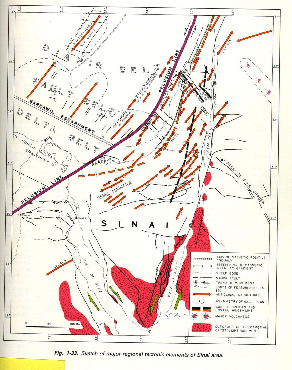
46 (c) Determination of Design Bases for Seismically Induced Floods and Water Waves. * The size of seismically induced floods and water waves which could affect a site from either locally or distantly generated seismic activity shall be determined. * Local topographic characteristics which might tend to modify the possible runup and drawdown at the site shall be considered. Adverse tide conditions shall also be taken into account in determining the effect of the floods and waves on the site. * The characteristics of the earthquake to be used in evaluating the offshore effects of local earthquakes must be determined.
47 d) Determination of Other Design Conditions (1) Soil Stability Vibratory ground motion associated with the Safe Shutdown Earthquake can cause soil instability due to ground disruption such as fissuring, differential consolidation, liquefaction, and cratering which is not directly related to surface faulting. The following geologic features which could affect the foundations of the proposed nuclear power plant structures shall be evaluated, taking into account the information concerning the physical properties of materials underlying the site:
48 (i) Areas of actual or potential surface or subsurface subsidence, uplift, or collapse resulting from: (a) Natural features such as tectonic depressions and cavernous or karst terrains, particularly those underlain by calcareous or other soluble deposits; (b) Man's activities such as withdrawal of fluid from or addition of fluid to the subsurface, extraction of minerals, or the loading effects of dams or reservoirs; and (c) Regional deformation.
49 (ii) Deformational zones such as shears, joints, fractures, folds, or combinations of these features. (iii) Zones of alteration or irregular weathering profiles and zones of structural weakness composed of crushed or disturbed materials. (iv) Unrelieved residual stresses in bedrock. (v) Rocks or soils that might be unstable because of their mineralogy, lack of consolidation, water content, or potentially undesirable response to seismic or other events. Seismic response characteristics to be considered shall include liquefaction, thixotropy,, differential consolidation, cratering,, and fissuring.
50 (2) Slope stability Stability of all slopes, both natural and artificial, the failure of which could adversely affect the nuclear power plant, shall be considered. An assessment shall be made of the potential effects of erosion or deposition and of combinations of erosion or deposition with seismic activity, taking into account information concerning the physical property of the materials underlying the site and the effects of the Safe Shutdown Earthquake.
51 (3) Cooling water supply Assurance of adequate cooling water supply for emergency and long-term shutdown decay heat removal shall be considered in the design of the nuclear power plant, taking in to account information concerning the physical properties of the materials underlying the site and the effects of the Safe Shutdown Earthquake and the design basis for surface faulting. Consideration of river blockage or diversion or other failures which may block the flow of cooling water, coastal uplift or subsidence, or tsunami runup and drawdown, and failure of dams and intake structures shall be included in the evaluation, where appropriate.
52 (4) Distant structures Those structures which are not located in the immediate vicinity of the site but which are safety related shall be designed to withstand the effect of the Safe Shutdown Earthquake and the design basis for surface faulting determined on a comparable basis to that of the nuclear power plant, taking into account the material underlying the structures and the different location with respect to that of the site.

53 Fig. Schematic map showing major tectonic elements (Said, 1981) of north Egypt showing El Dabaa NPP proposed site (in Salman 1995)
54 Bathymetry of the continental margin & adjacent deep sea in Eastern Mediterranean, contours in meters corrected for sound velocity (in Salman, 1995)
55 Fig. Seismic reflection profiles of the continental margin, north Egypt (in Salman, 1995)

56

57
58
59 (c) Seismically Induced Floods and Water Waves and Other Design Conditions. The size of seismically induced floods and water waves which could affect a site from either locally or distantly generated seismic activity shall be determined. Local topographic characteristics which might tend to modify the possible runup and drawdown at the site shall be considered. Adverse tide conditions shall also be taken into account in determining the effect of the floods and waves on the site. The characteristics of the earthquake to be used in evaluating the offshore effects of local earthquakes must be determined.
CRITERIA FOR NUCLEAR POWER PLANT SITE SELECTION
 CRITERIA FOR NUCLEAR POWER PLANT SITE SELECTION Junaid Ahmad Trainee Scientific Officer-C Atomic Minerals Directorate for Exploration & Research, Hyderabad. ABSTRACT For any engineering project, geotechnical
Tectonic Hazard Evaluations for Korean Nuclear Sites
 Tectonic Hazard Evaluations for Korean Nuclear Sites June 13-17, 2011 Jakarta, INDONESIA Hyunwoo LEE (heanu@kins.re.kr) Korea Institute of Nuclear Safety 1 2 3 4 5 Introduction Tectonic Environment of
Guidelines for Site-Specific Seismic Hazard Reports for Essential and Hazardous Facilities and Major and Special-Occupancy Structures in Oregon
 Guidelines for Site-Specific Seismic Hazard Reports for Essential and Hazardous Facilities and Major and Special-Occupancy Structures in Oregon By the Oregon Board of Geologist Examiners and the Oregon
IAEA SAFETY STANDARDS Geotechnical Aspects of Site Evaluation and Foundations in NPPs, NS-G-3.6
 IAEA SAFETY STANDARDS Geotechnical Aspects of Site Evaluation and Foundations in NPPs, NS-G-3.6 Regional Workshop on Volcanic, Seismic, and Tsunami Hazard Assessment Related to NPP Siting Activities and
GEOTECHNICAL ENGINEERING INVESTIGATION HANDBOOK Second Edition
 GEOTECHNICAL ENGINEERING INVESTIGATION HANDBOOK Second Edition Roy E. Hunt Taylor & Francis Taylor & Francis Croup Boca Raton London New York Singapore A CRC title, part of the Taylor & Francis imprint,
CHAPTER GEOLOGICALLY HAZARDOUS AREAS Applicability Regulations.
 CHAPTER 19.07 GEOLOGICALLY HAZARDOUS AREAS 19.07.010 Applicability. Geologically hazardous areas may pose a threat to the health and safety of citizens when incompatible development is sited in areas of
UGRC 144 Science and Technology in Our Lives/Geohazards
 UGRC 144 Science and Technology in Our Lives/Geohazards Session 3 Understanding Earthquakes and Earthquake Hazards Lecturer: Dr. Patrick Asamoah Sakyi Department of Earth Science, UG Contact Information:
Surface Processes Focus on Mass Wasting (Chapter 10)
") Surface Processes Focus on Mass Wasting (Chapter 10) 1. What is the distinction between weathering, mass wasting, and erosion? 2. What is the controlling force in mass wasting? What force provides resistance?
Surface Processes Focus on Mass Wasting (Chapter 10) 1. What is the distinction between weathering, mass wasting, and erosion? 2. What is the controlling force in mass wasting? What force provides resistance?
ENGINEER S CERTIFICATION OF FAULT AREA DEMONSTRATION (40 CFR )
") PLATTE RIVER POWER AUTHORITY RAWHIDE ENERGY STATION BOTTOM ASH TRANSFER (BAT) IMPOUNDMENTS LARIMER COUNTY, CO ENGINEER S CERTIFICATION OF FAULT AREA DEMONSTRATION (40 CFR 257.62) FOR COAL COMBUSTION RESIDUALS
PLATTE RIVER POWER AUTHORITY RAWHIDE ENERGY STATION BOTTOM ASH TRANSFER (BAT) IMPOUNDMENTS LARIMER COUNTY, CO ENGINEER S CERTIFICATION OF FAULT AREA DEMONSTRATION (40 CFR 257.62) FOR COAL COMBUSTION RESIDUALS
Rogun Hydropower Project
 Rogun Hydropower Project Dam site Geological investigations in the Downstream Right Bank Ascencio Lara Coyne et Bellier Almaty, 11-12 February 2013 Objectives of the presentation As the stability conditions
SLOPE STABILITY EVALUATION AND ACCEPTANCE STANDARDS
 INFORMATION BULLETIN / PUBLIC - BUILDING CODE REFERENCE NO.: LAMC 98.0508 Effective: 1-26-84 DOCUMENT NO. P/BC 2002-049 Revised: 11-1-02 Previously Issued As: RGA #1-84 SLOPE STABILITY EVALUATION AND ACCEPTANCE
SLOPE STABILITY EVALUATION AND ACCEPTANCE STANDARDS
 INFORMATION BULLETIN / PUBLIC - BUILDING CODE REFERENCE NO.: LABC 7006.3, 7014.1 Effective: 01-01-2017 DOCUMENT NO.: P/BC 2017-049 Revised: 12-21-2016 Previously Issued As: P/BC 2014-049 SLOPE STABILITY
Seismic Hazards in Site Evaluation for Nuclear Installations
 27 November 2018 IAEA SAFETY STANDARDS for protecting people and the environment Step 8 Soliciting comments by Member States Seismic Hazards in Site Evaluation for Nuclear Installations DRAFT SAFETY GUIDE
U.S. NUCLEAR REGULATORY COMMISSION March 2007 REGULATORY GUIDE OFFICE OF NUCLEAR REGULATORY RESEARCH
 U.S. NUCLEAR REGULATORY COMMISSION March 2007 REGULATORY GUIDE OFFICE OF NUCLEAR REGULATORY RESEARCH REGULATORY GUIDE 1.208 (Draft was issued as DG-1146, dated October 2006) A PERFORMANCE-BASED APPROACH
Siva Bharatha Murthy. T Page 4.31
 Importance of Geological Structures: The physical properties of rocks, mineral and other materials of civil engineering, like textures, grain size are very important for a civil engineer. Similarly the
Lecture Outline Wednesday-Monday April 18 23, 2018
 Lecture Outline Wednesday-Monday April 18 23, 2018 Questions? Lecture Final Exam Lecture Section 1 Friday May 4, 8:00-10:00am Lecture Section 2 Friday May 4, 3:10-5:10 pm Final Exam is 70% new material
8.0 SUMMARY AND CONCLUSIONS
 8.0 SUMMARY AND CONCLUSIONS In November 2008, Pacific Gas and Electric (PG&E) informed the U.S. Nuclear Regulatory Commission (NRC) that preliminary results from the Diablo Canyon Power Plant (DCPP) Long
IV. ENVIRONMENTAL IMPACT ANALYSIS E. GEOLOGY AND SOILS
 IV. ENVIRONMENTAL IMPACT ANALYSIS E. GEOLOGY AND SOILS The following section is a summary of the geotechnical report conducted for the Proposed Project. The Geotechnical Engineering Investigation (the
Module 9 : Foundation on rocks. Content
 FOUNDATION ON ROCKS Content 9.1 INTRODUCTION 9.2 FOUNDATION TYPES ON ROCKS 9.3 BEARING CAPCITY- SHALLOW FOUNDATION 9.3.1 Ultimate bearing capacity 9.3.2 Safe bearing pressure 9.3.3 Estimation of bearing
IV. ENVIRONMENTAL IMPACT ANALYSIS G. GEOLOGY AND SOILS
 IV. ENVIRONMENTAL IMPACT ANALYSIS G. GEOLOGY AND SOILS The following section is a summary of the geotechnical report conducted for the proposed project. The Report of Geotechnical Investigation Proposed
INTRODUCTION. Climate
 INTRODUCTION Climate Landslides are serious natural disasters in many parts of the world. Since the past 30 years, rainfall triggered landslides and debris flows had been one of the natural disasters of
BRIEFING MEMO ON RESERVOIR TRIGGERED SEISMICITY (RTS)
") BRIEFING MEMO ON RESERVOIR TRIGGERED SEISMICITY (RTS) 1. General. The issue of reservoir-triggered seismicity (RTS) has been controversial, and hotly debated, for many decades. There has been general recognition
BRIEFING MEMO ON RESERVOIR TRIGGERED SEISMICITY (RTS) 1. General. The issue of reservoir-triggered seismicity (RTS) has been controversial, and hotly debated, for many decades. There has been general recognition
Important Concepts. Earthquake hazards can be categorized as:
 Lecture 1 Page 1 Important Concepts Monday, August 17, 2009 1:05 PM Earthquake Engineering is a branch of Civil Engineering that requires expertise in geology, seismology, civil engineering and risk assessment.
Seismic Issues for California's Nuclear Power Plants. Norman Abrahamson University of California, Berkeley
 Seismic Issues for California's Nuclear Power Plants Norman Abrahamson University of California, Berkeley From UCERF 2 Seismic Setting for California s Nuclear Power Plants Major Offshore Strike-Slip Faults
STUDY GUIDE FOR MID-TERM EXAM KEY. Color, luster, cleavage, fracture, hardness, taste, smell, fluorescence, radioactivity, magnetism
 STUDY GUIDE FOR MID-TERM EXAM KEY 1. In which type of rock are fossils most likely to be found? Sedimentary Rocks 2. Which mineral is easily identified by smell? Sulfur 3. Which natural resource makes
CHAPTER 6, PRELIMINARY SITE INVESTIGATION CONTENTS
 CHAPTER 6, PRELIMINARY SITE INVESTIGATION CONTENTS - Page Purpose... 6-1 Assembly of data... 6-1 Use of aerial photographs... 6-2 Field study... 6-3 Mappix... 6-4 Repcrt of preliminary investigation...
LANDSLIDE HAZARDS. presented during the. TRAINING-WORKSHOP ON DISASTER RISK MANAGEMENT Rakdell Inn Virac, Catanduanes 03 July 2008
 LANDSLIDE HAZARDS presented during the TRAINING-WORKSHOP ON DISASTER RISK MANAGEMENT Rakdell Inn Virac, Catanduanes 03 July 2008 GEOLOGIC HAZARDS the probability of occurrence, within a specific period
Lecture # 6. Geological Structures
 1 Lecture # 6 Geological Structures ( Folds, Faults and Joints) Instructor: Dr. Attaullah Shah Department of Civil Engineering Swedish College of Engineering and Technology-Wah Cantt. 2 The wavy undulations
FAILURES IN THE AMAZON RIVERBANKS, IQUITOS, PERU
 FAILURES IN THE AMAZON RIVERBANKS, IQUITOS, PERU A.Carrillo-Gil University of Engineering & A.Carrillo Gil S.A.,Consulting Engineering,Lima,Peru L. Dominguez University of Engineering,Lima & The Maritime
Harmonized European standards for construction in Egypt
 Harmonized European standards for construction in Egypt EN 1998 - Design of structures for earthquake resistance Jean-Armand Calgaro Chairman of CEN/TC250 Organised with the support of the Egyptian Organization
Instability Investigate of Sarney dam abutments, under seismic loading
 Journal of Scientific Research and Development 2 (7): 129-133, 2015 Available online at www.jsrad.org ISSN 1115-7569 2015 JSRAD Instability Investigate of Sarney dam abutments, under seismic loading Majid
WHAT SEISMIC HAZARD INFORMATION THE DAM ENGINEERS NEED FROM SEISMOLOGISTS AND GEOLOGISTS?
 WHAT SEISMIC HAZARD INFORMATION THE DAM ENGINEERS NEED FROM SEISMOLOGISTS AND GEOLOGISTS? Martin WIELAND 1 ABSTRACT For large dam projects a site-specific seismic hazard analysis is usually recommended.
Introduction to Environmental Geology, 5e Case History: Indonesian Tsunami Indonesian Tsunami (2) Introduction Historic Tsunamis
 Introduction Historic Tsunamis") 1 2 3 4 5 6 7 8 9 Introduction to Environmental Geology, 5e Chapter 7 Tsunami Case History: Indonesian Tsunami December 26, 2004, within a few hours, close to 250,000 people were killed With no warning
1 2 3 4 5 6 7 8 9 Introduction to Environmental Geology, 5e Chapter 7 Tsunami Case History: Indonesian Tsunami December 26, 2004, within a few hours, close to 250,000 people were killed With no warning
Lecture Outlines PowerPoint. Chapter 5 Earth Science 11e Tarbuck/Lutgens
 Lecture Outlines PowerPoint Chapter 5 Earth Science 11e Tarbuck/Lutgens 2006 Pearson Prentice Hall This work is protected by United States copyright laws and is provided solely for the use of instructors
Impact : Changes to Existing Topography (Less than Significant)
") 4.2 Land Resources 4.2.1 Alternative A Proposed Action Impact 4.2.1-1: Changes to Existing Topography (Less than Significant) Development of the project site would involve grading and other earthwork as
4.2 Land Resources 4.2.1 Alternative A Proposed Action Impact 4.2.1-1: Changes to Existing Topography (Less than Significant) Development of the project site would involve grading and other earthwork as
ANVS Guidelines on Seismic Hazards in Site Evaluation for Nuclear Installations (revised version of IAEA standard SSG-9, 2010)
") ANVS Guidelines on Seismic Hazards in Site Evaluation for Nuclear Installations (revised version of IAEA standard SSG-9, 2010) 1 Foreword The ANVS (the Authority for Nuclear Safety and Radiation Protection)
ANVS Guidelines on Seismic Hazards in Site Evaluation for Nuclear Installations (revised version of IAEA standard SSG-9, 2010) 1 Foreword The ANVS (the Authority for Nuclear Safety and Radiation Protection)
Neotectonic Implications between Kaotai and Peinanshan
 Neotectonic Implications between Kaotai and Peinanshan Abstract Longitudinal Valley was the suture zone between the Philippine Sea plate and the Eurasia plate. Peinanshan was the southest segment of the
depression above scarp scarp
 1 LAB 1: FIELD TRIP TO McKINLEYVILLE AND MOUTH OF THE MAD RIVER OBJECTIVES: a. to look at geomorphic and geologic evidence for large scale thrust-faulting of young sediments in the Humboldt Bay region
State of Shimane Nuclear Power Station
 Investors Meeting for FY2014-2Q Financial Results State of Shimane Nuclear Power Station November 11, 2013 The Chugoku Electric Power Co., Inc. 1. Basic approach of the new regulatory standards 1 Under
9. GEOLOGY, SOILS, AND MINERALS
 June 28, 2018 Page 9-1 9. GEOLOGY, SOILS, AND MINERALS This EIR chapter describes the existing geological, soil, and mineral conditions in the planning area. The chapter includes the regulatory framework
Landslide analysis to estimate probability occurrence of earthquakes by software ArcGIS in central of Iran
 Research Journal of Recent Sciences ISSN 2277-2502 Res.J.Recent Sci. Landslide analysis to estimate probability occurrence of earthquakes by software ArcGIS in central of Iran Abstract Hamid Reza Samadi
Marine Science and Oceanography
 Marine Science and Oceanography Marine geology- study of the ocean floor Physical oceanography- study of waves, currents, and tides Marine biology study of nature and distribution of marine organisms Chemical
Introduction to Environmental Geology, 5e
 Lecture Presentation prepared by X. Mara Chen, Salisbury University Introduction to Environmental Geology, 5e Edward A. Keller Chapter 7 Tsunami Case History: Indonesian Tsunami December 26, 2004, within
STATE OF OREGON DEPARTMENT OF GEOLOGY AND MINERAL INDUSTRIES Suite 965, 800 NE Oregon St., #28 Portland, Oregon 97232
 OPEN-FILE REPORT O-00-04 Guidelines for Engineering Geologic Reports and Site-Specific Seismic Hazard Reports Developed and Adopted by the Oregon Board of Geologist Examiners STATE OF OREGON DEPARTMENT
Prof. B V S Viswanadham, Department of Civil Engineering, IIT Bombay
 19 Module 5: Lecture -1 on Stability of Slopes Contents Stability analysis of a slope and finding critical slip surface; Sudden Draw down condition, effective stress and total stress analysis; Seismic
4.9 GEOLOGY AND SOILS
 4.9 GEOLOGY AND SOILS 4.9.1 EXISTING CONDITIONS TOPOGRAPHY AND RELIEF Zone 40 is located in the central portion of Sacramento County. The topography of the county is represented by three physiographic
FUNDAMENTALS OF ENGINEERING GEOLOGY
 FUNDAMENTALS OF ENGINEERING GEOLOGY Prof. Dr. HUSSEIN HAMEED KARIM Building and Construction Engineering Department 2012 Preface The impulse to write this book stemmed from a course of geology given by
Seismic Reflection Imaging across the Johnson Ranch, Valley County, Idaho
 Seismic Reflection Imaging across the Johnson Ranch, Valley County, Idaho Report Prepared for the Skyline Corporation Lee M. Liberty Center for Geophysical Investigation of the Shallow Subsurface (CGISS)
Phase II Report: Project Definition Options. Dam Safety
 OSHPC BARKI TOJIK Phase II Report: Project Definition Options Dam Safety Part 1: Basic data & Dam Design DAM Safety 2 Geology / Geotechnics...: Tectonics / Seismicity : DAM Design - Dam Location - Type
Course Description. Course Objectives and Standards
 Earth and Space Science Curriculum Course Description Earth and Space Science 1 State # 3044 Grades offered: 10-12 Credits: A two credit course Prerequisite: none Counts as a Science Course for the General,
I. Locations of Earthquakes. Announcements. Earthquakes Ch. 5. video Northridge, California earthquake, lecture on Chapter 5 Earthquakes!
 51-100-21 Environmental Geology Summer 2006 Tuesday & Thursday 6-9:20 p.m. Dr. Beyer Earthquakes Ch. 5 I. Locations of Earthquakes II. Earthquake Processes III. Effects of Earthquakes IV. Earthquake Risk
3.8 Geology/Soils. Environmental Setting. Topography. Geology and Soils
 3.8 Geology/Soils This section examines whether implementation of the 2004 Land Use Mobility Elements, Zoning Code Revisions, and Central District Specific Plan the will expose people or structures to
Earthquakes and Earthquake Hazards Earth - Chapter 11 Stan Hatfield Southwestern Illinois College
 Earthquakes and Earthquake Hazards Earth - Chapter 11 Stan Hatfield Southwestern Illinois College What Is an Earthquake? An earthquake is the vibration of Earth, produced by the rapid release of energy.
Statistical Seismic Landslide Hazard Analysis: an Example from Taiwan
 Statistical Seismic Landslide Hazard Analysis: an Example from Taiwan Chyi-Tyi Lee Graduate Institute of Applied Geology, National Central University, Taiwan Seismology Forum 27: Natural Hazards and Surface
Miami-Dade College. The student will demonstrate a basic knowledge of the origin and evolution of the Earth and its planetary environment.
 Miami-Dade College Common Course Number: GLY 3884 Course Title: Environmental Geology Catalog Course Description: This course focuses on the study of the application of geology to the interactions between
IV. ENVIRONMENTAL IMPACT ANALYSIS E. GEOLOGY/SOILS
 IV. ENVIRONMENTAL IMPACT ANALYSIS E. GEOLOGY/SOILS Except where otherwise noted, the following Section is based on the Preliminary Geotechnical Investigation, Proposed Medical Office Buildings and Mixed-Use
UGRC 144 Science and Technology in Our Lives/Geohazards
 UGRC 144 Science and Technology in Our Lives/Geohazards Flood and Flood Hazards Dr. Patrick Asamoah Sakyi Department of Earth Science, UG, Legon College of Education School of Continuing and Distance Education
Earthquakes Chapter 19
 Earthquakes Chapter 19 Does not contain complete lecture notes. What is an earthquake An earthquake is the vibration of Earth produced by the rapid release of energy Energy released radiates in all directions
Earth Science. Explain how Earth's biogeochemical cycles create a balance of materials. Examine the importance of biogeochemical cycles.
 Unit 1: DYNAMIC STRUCTURE OF EARTH Introduction to Understand that earth science is based upon the four sciences of astronomy, geology, meteorology, and oceanography. Identify topics studied within the
3.12 Geology and Topography Affected Environment
 3 Affected Environment and Environmental Consequences 3.12 Geology and Topography 3.12.1 Affected Environment 3.12.1.1 Earthquakes Sterling Highway MP 45 60 Project Draft SEIS The Kenai Peninsula is predisposed
Faults, folds and mountain building
 Faults, folds and mountain building Mountain belts Deformation Orogens (Oro = Greek all changes for mountain, in size, shape, genesis orientation, = Greek for or formation) position of a rock mass Structural
Elastic Rebound Theory
 Earthquakes Elastic Rebound Theory Earthquakes occur when strain exceeds the strength of the rock and the rock fractures. The arrival of earthquakes waves is recorded by a seismograph. The amplitude of
 12 10 8 6 4 2 0 40-50 50-60 60-70 70-80 80-90 90-100 Fresh Water What we will cover The Hydrologic Cycle River systems Floods Groundwater Caves and Karst Topography Hot springs Distribution of water in
GEOLOGY, SOILS, AND SEISMICITY
 4.9 GEOLOGY, SOILS, AND SEISMICITY 4.9.1 Introduction Information about the geological conditions and seismic hazards in the study area was summarized in the FEIR, and was based on the Geotechnical Exploration
3.0 SUMMARY OF POTENTIAL GEOTECHNICAL IMPACTS AND MITIGATION MEASURES
 3.0 SUMMARY OF POTENTIAL GEOTECHNICAL IMPACTS AND MITIGATION MEASURES This section summarizes the principal geotechnical conditions that occur in the project area. The potential impact that each condition
IV. ENVIRONMENTAL IMPACT ANALYSIS G. GEOLOGY AND SOILS
 IV. ENVIRONMENTAL IMPACT ANALYSIS G. GEOLOGY AND SOILS The following section is based upon the City of El Segundo General Plan and General Plan EIR and addresses the following geologic issues: soil erosion,
TAKE HOME EXAM 8R - Geology
 Name Period Date TAKE HOME EXAM 8R - Geology PART 1 - Multiple Choice 1. A volcanic cone made up of alternating layers of lava and rock particles is a cone. a. cinder b. lava c. shield d. composite 2.
OIKOS > landslide > mechanism >predisposing causes
 predisposing causes and trigger OIKOS > landslide > mechanism >predisposing causes Landslides are events that occur in space and time. As such, it is usually possible to identify both one or more landslide
Geologic Hazards. Montour County Multi-jurisdictional. General. Earthquake
 Geologic Hazards General s are very rare in Pennsylvania and have caused little damage with no reported injuries or causalities. s that do occur in Pennsylvania happen deep within the Earth s crust. This
EARTHQUAKE SAFETY OF AN ARCH-GRAVITY DAM WITH A HORIZONTAL CRACK IN THE UPPER PORTION OF THE DAM
 EARTHQUAKE SAFETY OF AN ARCH-GRAVITY DAM WITH A HORIZONTAL CRACK IN THE UPPER PORTION OF THE DAM Martin WIELAND 1 And Sujan MALLA 2 SUMMARY A horizontal crack first appeared along the downstream wall of
FRIENDS OF THE EEL RIVER
 FRIENDS OF THE EEL RIVER Working for the recovery of our Wild & Scenic River, its fisheries and communities. Frank Blackett, Regional Engineer Office of Energy Projects Division of Dam Safety and Inspections
Construction Technical Specifications on Rock-Foundation Excavating Engineering of Hydraulic Structures
 DL Electric Power Industry Standard of the People's Republic of China P DL I T 5389-- Construction Technical Specifications on Rock-Foundation Excavating Engineering of Hydraulic Structures DL/T 5389-
GEOL 380: Earthquake Hazards in the Puget Sound Region (in class and assignment) Due in class Wednesday, Nov 109th
 Due in class Wednesday, Nov 109th") GEOL 380: Earthquake Hazards in the Puget Sound Region (in class and assignment) Due in class Wednesday, Nov 109th The purpose of this exercise/assignment is for you to gain practice and experience in
GEOL 380: Earthquake Hazards in the Puget Sound Region (in class and assignment) Due in class Wednesday, Nov 109th The purpose of this exercise/assignment is for you to gain practice and experience in
Weathering, Mass Wasting and Karst
 Weathering, Mass Wasting and Karst Capable of wearing down anything that the internal processes can build. Gravity, water, wind and ice Denudation - the overall effect of disintegration, wearing away and
Physical Geography A Living Planet
 Physical Geography A Living Planet The geography and structure of the earth are continually being changed by internal forces, like plate tectonics, and external forces, like the weather. Iguaçu Falls at
Earthquakes. Earthquakes are caused by a sudden release of energy
 Earthquakes Earthquakes are caused by a sudden release of energy The amount of energy released determines the magnitude of the earthquake Seismic waves carry the energy away from its origin Fig. 18.1 Origin
Structural Analysis and Tectonic Investigation of Chamshir Dam Site, South West Zagros
 Open Journal of Geology, 2015, 5, 136-143 Published Online March 2015 in SciRes. http://www.scirp.org/journal/ojg http://dx.doi.org/10.4236/ojg.2015.53013 Structural Analysis and Tectonic Investigation
Multi-Jurisdictional Hazard Mitigation Plan. Table C.10 The Richter Scale. Descriptor Richter Magnitude Earthquake Effects
 Geologic Hazards Earthquake Earthquakes are very rare in Pennsylvania and have caused little damage, with no reported injuries or causalities. Earthquakes that do occur in Pennsylvania happen deep within
Earthquake hazards. Aims 1. To know how hazards are classified 2. To be able to explain how the hazards occur 3. To be able to rank order hazards
 Earthquake hazards Aims 1. To know how hazards are classified 2. To be able to explain how the hazards occur 3. To be able to rank order hazards Types of hazard Primary A direct result of the earthquake
Chapter Overview. Bathymetry. Measuring Bathymetry. Measuring Bathymetry
 CHAPTER 3 Marine Provinces Chapter Overview The study of bathymetry determines ocean depths and ocean floor topography. Echo sounding and satellites are efficient bathymetric tools. Most ocean floor features
3.1 GEOLOGY AND SOILS Introduction Definition of Resource
 3.1 GEOLOGY AND SOILS 3.1.1 Introduction 3.1.1.1 Definition of Resource The geologic resources of an area consist of all soil and bedrock materials. This includes sediments and rock outcroppings in the
Extra Credit Assignment (Chapters 4, 5, 6, and 10)
") GEOLOGY 306 Laboratory Instructor: TERRY J. BOROUGHS NAME: Extra Credit Assignment (Chapters 4, 5, 6, and 10) For this assignment you will require: a calculator and metric ruler. Chapter 4 Objectives:
GEOLOGY 306 Laboratory Instructor: TERRY J. BOROUGHS NAME: Extra Credit Assignment (Chapters 4, 5, 6, and 10) For this assignment you will require: a calculator and metric ruler. Chapter 4 Objectives:
Geology, Soils, and Seismicity
 Section 3.8 Geology, Soils, and Seismicity Introduction This section generally evaluates the effects of the alternatives analyzed in this Supplemental DEIS with regard to geology, soils and seismicity.
Magnitude 6.3 SOUTH ISLAND OF NEW ZEALAND
 A magnitude 6.3 earthquake shook the southern New Zealand city of Christchurch. At least 100 people are reported dead, and there are reports of collapsed buildings, cracked streets and flooding due to
Lecture 9 faults, folds and mountain building
 Lecture 9 faults, folds and mountain building Rock deformation Deformation = all changes in size, shape, orientation, or position of a rock mass Structural geology is the study of rock deformation Deformation
b Blackwell Science Environmental Geology PRINCIPLES AND PRACTICE
 Environmental Geology PRINCIPLES AND PRACTICE Fred G. Bell Department of Geology and Applied Geology University of Natal, Durban, South Africa b Blackwell Science Preface, ix 1 Introduction, 1 1.1 Planning
General Geologic Setting and Seismicity of the FHWA Project Site in the New Madrid Seismic Zone
 General Geologic Setting and Seismicity of the FHWA Project Site in the New Madrid Seismic Zone David Hoffman University of Missouri Rolla Natural Hazards Mitigation Institute Civil, Architectural & Environmental
Earthquakes. Building Earth s Surface, Part 2. Science 330 Summer What is an earthquake?
 Earthquakes Building Earth s Surface, Part 2 Science 330 Summer 2005 What is an earthquake? An earthquake is the vibration of Earth produced by the rapid release of energy Energy released radiates in all
CHAPTER 2 NOTES -FOUNDATIONS OF GEOLOGY-
 CHAPTER 2 NOTES -FOUNDATIONS OF GEOLOGY- LESSON 2.1A: LAYERS OF THE EARTH GEOLOGY Geology- LAYERS OF THE EARTH Earth has 3 major layers based on their composition: o - the outer layer, made of solid rock.
EQ Monitoring and Hazards NOTES.notebook. January 07, P-wave. S-wave. surface waves. distance
 Earthquake Monitoring and Hazards Reading a Seismogram General guidelines: P-wave First disruption of trace = Second disruption of trace = surface waves Largest disruption of trace = Not the distance to
3.18 GEOLOGY AND SOILS
 3.18 GEOLOGY AND SOILS This section discusses geologic resource concerns as they relate to the environment, public safety, and project design both during construction and after completion of the project.
Western New York Nuclear Service Center Background and History
 Western New York Nuclear Service Center Background and History Paul J. Bembia, NYSERDA West Valley Program Director April 27, 2011 Development of a Civilian Nuclear Industry The roots of the West Valley
J. Paul Guyer, P.E., R.A.
 J. Paul Guyer, P.E., R.A. Paul Guyer is a registered mechanical engineer, civil engineer, fire protection engineer and architect with over 35 years experience in the design of buildings and related infrastructure.
Deep Borehole Disposal Performance Assessment and Criteria for Site Selection
 Deep Borehole Disposal Performance Assessment and Criteria for Site Selection Sandia is a multiprogram laboratory operated by Sandia Corporation, a Lockheed Martin Company, for the United States Department
4.5 GEOLOGY, SOILS AND SEISMICITY
 4.5 This section summarizes information on geology, soils and seismic hazards, and mineral resources in the Truckee area, as well as potential area-wide geologic hazards and regional seismic characteristics
4. Geotechnical and Geological Aspects. 4.1 Geotechnical Aspects
 4. Geotechnical and Geological Aspects 4.1 Geotechnical Aspects A preliminary reconnaissance of the geotechnical conditions of Duzce, Kaynasli, and Bolu urban areas was done during the Turkey Expedition
Map shows 3 main features of ocean floor
 Map shows 3 main features of ocean floor 2017 Pearson Education, Inc. Chapter 3 Marine Provinces 2017 Pearson Education, Inc. 1 Chapter 3 Overview The study of bathymetry determines ocean depths and ocean
B-1. Attachment B-1. Evaluation of AdH Model Simplifications in Conowingo Reservoir Sediment Transport Modeling
 Attachment B-1 Evaluation of AdH Model Simplifications in Conowingo Reservoir Sediment Transport Modeling 1 October 2012 Lower Susquehanna River Watershed Assessment Evaluation of AdH Model Simplifications
Section Forces Within Earth. 8 th Grade Earth & Space Science - Class Notes
 Section 19.1 - Forces Within Earth 8 th Grade Earth & Space Science - Class Notes Stress and Strain Stress - is the total force acting on crustal rocks per unit of area (cause) Strain deformation of materials
Earthquakes. Earthquake Magnitudes 10/1/2013. Environmental Geology Chapter 8 Earthquakes and Related Phenomena
 Environmental Geology Chapter 8 Earthquakes and Related Phenomena Fall 2013 Northridge 1994 Kobe 1995 Mexico City 1985 China 2008 Earthquakes Earthquake Magnitudes Earthquake Magnitudes Richter Magnitude