Western New York Nuclear Service Center Background and History
|
|
|
- Alvin Gray
- 5 years ago
- Views:
Transcription

1 Western New York Nuclear Service Center Background and History Paul J. Bembia, NYSERDA West Valley Program Director April 27, 2011


2 Development of a Civilian Nuclear Industry The roots of the West Valley facility can be traced back to the federal government programs of the 1950s that were created to develop peaceful uses for nuclear energy. Atoms for Peace 1953 Atomic Energy Act of


3 Development of a Civilian Reprocessing Capability "The Commission's program," AEC chairman Lewis L. Strauss explained, "is directed toward encouraging development of the uses of atomic energy in the framework of the American free enterprise system." In 1957, AEC announced that it would: Make AEC technology on reprocessing available to private industry; Invite proposals by private industry to design, construct, and operate reprocessing plants; and Provide a baseload of fuel from AEC production reactors until the construction of additional commercial power reactors created an adequate demand for spent fuel reprocessing services. 3


4 Development of a Civilian Reprocessing Capability New York State became interested in the AEC privatization program as a way to promote industrial development within the State. New York established an Office of Atomic Development in By 1961, the AOD acquired 3,300 acres in the town of Ashford in Cattaraugus County with the intent of establishing a reprocessing facility. 4


5 Western New York Nuclear Service Center is Created The decision to locate the reprocessing plant in Western New York was greeted as positive economic news for the local community and the region. Unlimited possibilities 5


6 Western New York Nuclear Service Center is Created The siting of the facility also resulted in the displacement of some long-time residents of the town of Ashford. 6


7 Western New York Nuclear Service Center Location WNY Nuclear Service Center Because the property would be Stateowned and tax-exempt, a PILOT was established to defray property tax losses 7

 and American Machine and")
 to pursue the reprocessing venture.")
8 Agreements are Reached with Nuclear Fuel Services, Inc. to Build and Operate the Reprocessing Facility The Davison Chemical Company (which would be bought out by W.R. Grace and Company) and American Machine and Foundry Co. set up Nuclear Fuel Services Inc. (NFS) to pursue the reprocessing venture. Ground was broken in June


9 Reprocessing Operations Begin in 1966 NFS was licensed under 10 CFR Part 50 as the operator of the facility, and the New York State Atomic Research and Development Authority was licensed as the owner. The construction cost was about $33 million. AEC set the fee structure for reprocessing. NFS could not charge more than 15% above the AECpublished charges based on a conceptual AEC reprocessing plant. Construction was completed in 1966, and the AEC granted a provisional operating license for the facility. 9


10 Western New York Nuclear Service Center During Reprocessing WNY Nuclear Service Center WNY Boundary Nuclear Service Center Boundary Reprocessing Facilities Managed and operated by NFS, Licensed by the AEC (NRC) State-Licensed Disposal Area Managed and operated by NFS, Licensed and permitted by NYS 10

11 NFS Ends Reprocessing Operations NFS halted reprocessing after six years of operation to increase capacity, reduce worker dose and reduce radioactivity of effluents. NFS expected the modifications to cost $15 million. New requirements were issued by AEC related to earthquake and tornado protection, and waste management. NFS estimated that the requirements could cost $600 million, and said it would not resume reprocessing at West Valley. In 1976, NFS informed New York that it intended to turn the facility and its waste over to New York


12 High-Level Waste Demonstration Project New York State would not accept the facility and wastes from NFS. Congress held hearings, directed the GAO to investigate, and directed DOE to study options for the future of the Center. Congress passed the West Valley Demonstration Project Act in The reprocessing facility at West Valley failed to live up to its high expectations. A combination of economic factors, technological difficulties, and an evolving regulatory framework led to the failure of the facility. President Carter Signs the WVDP Act 12 12
 CPC Waste Storage Area Remote-Handled Waste Facility HLW Storage Tanks Vitrification")
13 Western New York Nuclear Service Center Today North Plateau Groundwater Plume Radioactive Waste Storage Facilities Liquid Waste Treatment Facility Lagoons State-Licensed Disposal Area Main Plant Process Building NRC-Licensed Disposal Area Drum Cell (Empty) CPC Waste Storage Area Remote-Handled Waste Facility HLW Storage Tanks Vitrification Facility 13
14 Western New York Nuclear Service Center Geology Overview Paul J. Bembia NYSERDA West Valley Program Director April 27, 2011
.")

15 Formation of Bedrock in Western New York Modified from Scotese, C.R., 2002, (PALEOMAP website). Western New York 400 million years ago, Western New York is covered by a tropical sea, south of the equator. 2


16 Formation of Bedrock in Western New York Modified from Scotese, C.R., 2002, (PALEOMAP website). Western New York 300 million years ago, Western New York has emerged from the sea. 3

")
17 Erosion and Formation of Bedrock Structures Mountains Western New York Faults Modified from Scotese, C.R., 2002, (PALEOMAP website). 250 million years ago, continental collision (North America and Africa) causes rock deformation and mountain building (the Appalachians) to the east. 4

18 Bedrock Geology of Western New York WVNS, 1993, WVDP-EIS-004, Geology Environmental Information Document Generalized Bedrock Geology of Western New York South-dipping layers of bedrock eroded and produced east-west belts of rock across western and central New York. 5 Van Divers, B, 1985, Roadside Geology of New York, Mountain Press Publishing.


19 Glacial Deposits in Western New York Continental ice sheets covered Western New York during the last ice age from ~2 million to ~12,000 years ago. Arctic Ice Sheet work-archives-arctic.html Limit of Pleistocene Ice Sheets of North America Driscoll, FG, 1986, Groundwater and Wells, Second Ed., Johnson Division 6


20 Glacial Deposits at the WNYNSC Glaciers carry and deposit large quantities of sediment. Interbedded sand, silt and clay deposits at the Center Retreating glaciers leave a complicated sequence of unconsolidated sediments. 7

21 Western New York Nuclear Service Center Northeast portion of Ashford Hollow, NY 7.5 Minute Quadrangle Cross Section Line 8 NYS DOT, 1988

22 Geologic Cross Section Through the Developed Areas of the WNYSNC NOTE: Vertical Scale = ¼ horizontal scale. Adapted from Dana et al. (1979a) 9
23 North Plateau Subsurface Geology 10
24 South Plateau Subsurface Geology 11

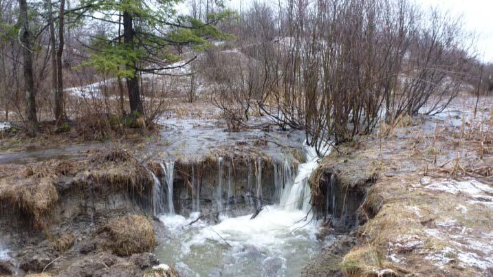
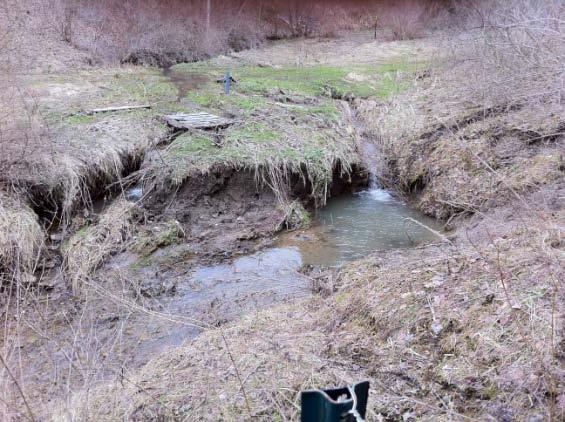
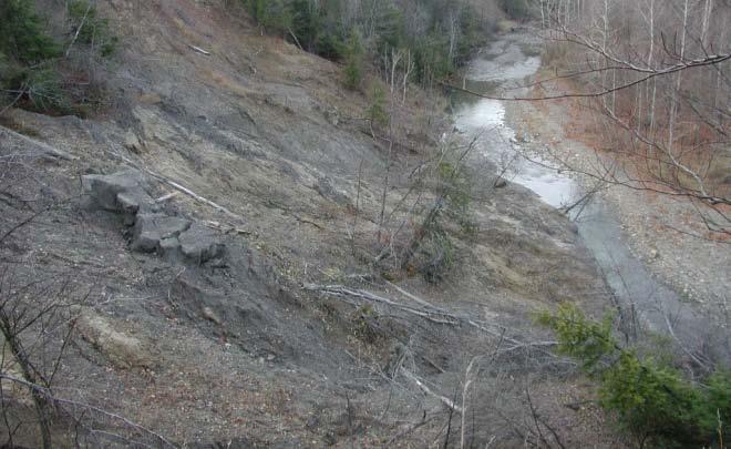
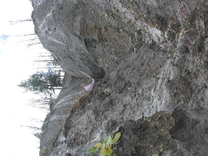
25 Erosion is a Significant Long- and Short-Term Issue Stream Erosion Stream Erosion 12
Cattaraugus Creek: A Story of Flowing Water and the Geology of the Channel It Flows Through Presentation to West Valley Citizen Task Force 4/27/16
 Cattaraugus Creek: A Story of Flowing Water and the Geology of the Channel It Flows Through Presentation to West Valley Citizen Task Force 4/27/16 Raymond C. Vaughan, Ph.D. What happens if you drop a
PALEOGEOGRAPHY of NYS. Definitions GEOLOGIC PROCESSES. Faulting. Folding 9/6/2012. TOPOGRAPHIC RELIEF MAP of NYS GRADATIONAL TECTONIC
 TOPOGRAPHIC RELIEF MAP of NYS PALEOGEOGRAPHY of NYS Prof. Anthony Grande AFG 2012 Definitions GEOLOGIC PROCESSES Geography: study of people living on the surface of the earth. Geology: the scientific study
J.H. Campbell Generating Facility Pond A - Location Restriction Certification Report
 J.H. Campbell Generating Facility Pond A - Location Restriction Certification Report Pursuant to: 40 CFR 257.60 40 CFR 257.61 40 CFR 257.62 40 CFR 257.63 40 CFR 257.64 Submitted to: Consumers Energy Company
EPS 50 - Lab 10: Groundwater Flow and Glaciers
 Name: EPS 50 - Lab 10: Groundwater Flow and Glaciers Part 1: Groundwater Flow Part 2: Darcy s Law Part 3: Glacial Deposits and Flow -Chapter 17, p. 478-492: Hydrology of Groundwater -Chapter 17, p. 485-486:
The Geology of Sebago Lake State Park
 Maine Geologic Facts and Localities September, 2002 43 55 17.46 N, 70 34 13.07 W Text by Robert Johnston, Department of Agriculture, Conservation & Forestry 1 Map by Robert Johnston Introduction Sebago
The outermost container into which vitrified high level waste or spent fuel rods are to be placed. Made of stainless steel or inert alloy.
 Glossary of Nuclear Waste Terms Atom The basic component of all matter; it is the smallest part of an element having all the chemical properties of that element. Atoms are made up of protons and neutrons
Plan of Development Mountain Valley Pipeline Project. APPENDIX P Plan for Unanticipated Discovery of Paleontological Resources
 APPENDIX P Plan for Unanticipated Discovery of Paleontological Resources Appendix P Plan for Unanticipated Discovery of Paleontological Resources Prepared by: TABLE OF CONTENTS 1.0 INTRODUCTION... 1 1.1
For Sale - 56 Acre Sandstone Quarry State Route 511, Oberlin/Kipton, OH 44075
 14647 State Route 511, Oberlin/Kipton, OH 44075 56 ACRES Vermilion Rd Gifford Rd Haigh Rd 44 Summary The Kipton sandstone quarry is included in 56 acre tract owned by Terry A. Johnson, of Huron, Ohio.
Department of Energy OffIce of Worker Protection Programs and Hazards Management Radiological Control Technical Position RCTP
 OffIce of Worker Protection Programs and Hazards Management Issue: The occupational radiation protection regulations established by the (DOE) and Nuclear Regulatory Commission (NRC) are similar in many
Current Status of Program for Geological Disposal of high-level radioactive waste (HLW) in Japan 1
 in Japan 1") Current Status of Program for Geological Disposal of high-level radioactive waste (HLW) in Japan 1 Shunsuke Kondo, Dr. President The Nuclear Waste Management Organization of Japan (NUMO) In Japan, the
Current Status of Program for Geological Disposal of high-level radioactive waste (HLW) in Japan 1 Shunsuke Kondo, Dr. President The Nuclear Waste Management Organization of Japan (NUMO) In Japan, the
Cuyama Basin North Fork Vineyard
 Cuyama Basin North Fork Vineyard Company Background plus Data Insights to Support GSP Development for the Cuyama Basin Presented by Grapevine Capital Partners and Cleath-Harris Geologists April 26th, 2018
Landscape. Review Note Cards
 Landscape Review Note Cards Last Ice Age Pleistocene Epoch that occurred about 22,000 Years ago Glacier A large, long lasting mass of ice which forms on land and moves downhill because of gravity. Continental
Terrain Units PALEOGEOGRAPHY: LANDFORM CREATION. Present Geology of NYS. Detailed Geologic Map of NYS
 NYS TOPOGRAPHY Why so? PALEOGEOGRAPHY: LANDFORM CREATION Prof. Anthony Grande AFG 014 Present Geology of NYS Detailed Geologic Map of NYS Generalized Geology Detailed Geology Hot links to the fold out
ENGINEER S CERTIFICATION OF FAULT AREA DEMONSTRATION (40 CFR )
") PLATTE RIVER POWER AUTHORITY RAWHIDE ENERGY STATION BOTTOM ASH TRANSFER (BAT) IMPOUNDMENTS LARIMER COUNTY, CO ENGINEER S CERTIFICATION OF FAULT AREA DEMONSTRATION (40 CFR 257.62) FOR COAL COMBUSTION RESIDUALS
PLATTE RIVER POWER AUTHORITY RAWHIDE ENERGY STATION BOTTOM ASH TRANSFER (BAT) IMPOUNDMENTS LARIMER COUNTY, CO ENGINEER S CERTIFICATION OF FAULT AREA DEMONSTRATION (40 CFR 257.62) FOR COAL COMBUSTION RESIDUALS
Name: Mid-Year Review #2 SAR
 Name: Mid-Year Review #2 SAR Base your answers to questions 1 through 3 on on the diagram below, which shows laboratory materials used for an investigation of the effects of sediment size on permeability,
Welcome to the NRC. Nuclear Energy Tribal Working Group 10/13/2016
 Welcome to the NRC Nuclear Energy Tribal Working Group 10/13/2016 NRC Tribal Policy Statement Final draft delivered to the Commission August 23 rd, 2016 Commenter panel invited to present before the Commission:
Section 11.1 pp Where Mountains Form
 Section 11.1 pp. 236 237 Where Mountains Form Chapter 11 Set a Purpose: TE, p. 236 Reading Study Guide, p. 36 Discussion: TE, p. 236 Differentiating ion Reading Support: TE, p. 236 Visual Teaching Interpret
Glacial Deposition and Groundwater in Dutchess County
 Glacial Deposition and Groundwater in Dutchess County Name: Period: Thousands of years ago an enormous ice sheet blanketed the Hudson Valley in what was called the Wisconsinan Glaciation. The ice reshaped
TOPOGRAPHIC RELIEF MAP of NYS. LANDFORMS of NYS. Landforms. Creation of NYS Landforms 9/22/2011
 TOPOGRAPHIC RELIEF MAP of NYS LANDFORMS of NYS Prof. Anthony Grande AFG 2011 Landforms The basis of present-day landforms (surface features) is the bedrock geology that has been worked on by the forces
IV. ENVIRONMENTAL IMPACT ANALYSIS G. GEOLOGY AND SOILS
 IV. ENVIRONMENTAL IMPACT ANALYSIS G. GEOLOGY AND SOILS The following section is a summary of the geotechnical report conducted for the proposed project. The Report of Geotechnical Investigation Proposed
RAYMOND SIEVER Harvard University
 E A R T H FOURTH EDITION FRANK PRESS National Academy of Sciences RAYMOND SIEVER Harvard University W. H. Freeman and Company New York Preface xiii Acknowledgments xviii PART I PROLOGUE CHAPTER 1 HISTORY
August 23, Washington, D.C Washington, D.C
 August 23, 2010 Thomas S. Moore, Chairman Paul S. Ryerson Atomic Safety and Licensing Board Atomic Safety and Licensing Board U.S. Nuclear Regulatory Commission U.S. Nuclear Regulatory Commission Washington,
Name. 4. The diagram below shows a soil profile formed in an area of granite bedrock. Four different soil horizons, A, B, C, and D, are shown.
 Name 1. In the cross section of the hill shown below, which rock units are probably most resistant to weathering? 4. The diagram below shows a soil profile formed in an area of granite bedrock. Four different
Name: NYS Geology and Landscapes and some River stuff
 Name: NYS Geology and Landscapes and some River stuff 1. Which types of surface bedrock are most likely found near Jamestown, New York? A) slate and marble B) quartzite and granite C) shale and sandstone
NUCLEAR POWER PLANT SITE SELECTION
 NUCLEAR POWER PLANT SITE SELECTION ABDELATY B. SALMAN Ex-Chairman Nuclear Materials Authority, Cairo, Egypt I. Introduction The aim of this article is to present the requirements and characteristics for
LANDFORMS of NYS. Landforms. Exercise 4 9/13/2012. TOPOGRAPHIC RELIEF MAP of NYS. Physiographic map of NYS and vicinity showing Surface Features
 TOPOGRAPHIC RELIEF MAP of NYS LANDFORMS of NYS Prof. Anthony Grande AFG 2012 Landforms REMINDER: The basis of present-day landforms (surface features) is the bedrock geology that has been worked on by
Lecture Outline Lecture Outline Monday April 9-16, 2018 Questions? Announcements:
 Lecture Outline Lecture Outline Monday April 9-16, 2018 Questions? Announcements: Geology 101 Night Video: The Day After Tomorrow Hollywood disaster movie about the onset of a glacial period When: Monday
Big Rivers Electric Corporation Disposal of Coal Combustion Residuals (CCR) from Electric Utilities Final Rule CCR Impoundment Liner Assessment Report
 from Electric Utilities Final Rule CCR Impoundment Liner Assessment Report") Big Rivers Electric Corporation Disposal of Coal Combustion Residuals (CCR) from Electric Utilities Final Rule CCR Impoundment Liner Assessment Report CCR Surface Impoundment Information Name: Operator:
Big Rivers Electric Corporation Disposal of Coal Combustion Residuals (CCR) from Electric Utilities Final Rule CCR Impoundment Liner Assessment Report CCR Surface Impoundment Information Name: Operator:
!!!!! STOP!!!!! What is environmental geology? Earth as a closed system implies nearly everything is cycled, recycled
 What is environmental geology?!!!!! STOP!!!!! Geology Study of rocks and minerals that comprise earth s surface and interior and the natural processes that shape the earth s surface and interior over all
!!!!! STOP!!!!! What is environmental geology?
 !!!!! STOP!!!!! What is environmental geology? Geology Study of rocks and minerals that comprise earth s surface and interior and the natural processes that shape the earth s surface and interior over
UALR Radiation Safety Office
 UALR Radiation Safety Office ETAS-329 501-569 8210 Graduate Institute of Technology University of Arkansas at Little Rock Regulatory Authority Nuclear Regulatory Commission (NRC) EPA, DoE, DoT, OSHA Agreement
WASTE MANAGEMENT GLOSSARY
 IAEA-TECDOC-264 RADIOACTIVE WASTE MANAGEMENT GLOSSARY A TECHNICAL DOCUMENT ISSUED RADIOACTIVE WASTE MANAGEMENT GLOSSARY IAEA, VIENNA, 1982 Printed by the IAEA in Austria April 1982 PLEASE BE AWARE THAT
 Page 1 of 9 Name: Base your answer to the question on the diagram below. The arrows show the direction in which sediment is being transported along the shoreline. A barrier beach has formed, creating a
4. The map below shows a meandering stream. Points A, B, C, and D represent locations along the stream bottom.
 1. Sediment is deposited as a river enters a lake because the A) velocity of the river decreases B) force of gravity decreases C) volume of water increases D) slope of the river increases 2. Which diagram
core mantle crust the center of the Earth the middle layer of the Earth made up of molten (melted) rock
 rock") core the center of the Earth mantle the middle layer of the Earth made up of molten (melted) rock crust the surface layer of the Earth that includes the continents and oceans 1 continental drift the theory
core the center of the Earth mantle the middle layer of the Earth made up of molten (melted) rock crust the surface layer of the Earth that includes the continents and oceans 1 continental drift the theory
PROMISED LAND STATE PARK PIKE COUNTY ANCIENT RIVERS AND AGES OF ICE
 PENNSYLVANIA TRAIL OF GEOLOGY PARK GUIDE 18 PROMISED LAND STATE PARK PIKE COUNTY ANCIENT RIVERS AND AGES OF ICE Promised Land State Park is located on a broad upland surface known as the Pocono Plateau.
Question #1: What are some ways that you think the climate may have changed in the area where you live over the past million years?
 Reading 5.2 Environmental Change Think about the area where you live. You may see changes in the landscape in that area over a year. Some of those changes are weather related. Others are due to how the
The Building of the NYC Region
 The Building of the NYC Region Definitions Fall Line marks the area where an upland region (continental bedrock) and a coastal plain meet Piedmont the plateau region of the eastern United States which
The Niagara Escarpment extends from western New York, through the GTA all the way up to Manitoulin Island and into Michigan and Wisconsin.
 is southern Ontario s most prominent topographic feature, extending more than 500 kilometres from western New York, through Niagara Falls and the western part of the Greater Toronto Area (GTA), and north
Module 10: Resources and Virginia Geology Topic 4 Content: Virginia Geology Notes
 Virginia is composed of a very diverse landscape that extends from the beaches and barrier islands all of the way to the highly elevated Appalachian Plateau. Geologists have discovered ancient shallow
Chapter 6, Part Colonizers arriving in North America found extremely landscapes. It looked different to region showing great.
 Social Studies 9 Unit 1 Worksheet Chapter 6, Part 1. 1. Colonizers arriving in North America found extremely landscapes. It looked different to region showing great. 2. The Earth is years old and is composed
How do glaciers form?
 Glaciers What is a Glacier? A large mass of moving ice that exists year round is called a glacier. Glaciers are formed when snowfall exceeds snow melt year after year Snow and ice remain on the ground
POLICY ISSUE (INFORMATION)
") POLICY ISSUE (INFORMATION) August 12, 2011 SECY-11-0112 FOR: FROM: SUBJECT: The Commissioners Michael R. Johnson, Director /RA/ Office of New Reactors STAFF ASSESSMENT OF SELECTED SMALL MODULAR REACTOR
POLICY ISSUE (INFORMATION) August 12, 2011 SECY-11-0112 FOR: FROM: SUBJECT: The Commissioners Michael R. Johnson, Director /RA/ Office of New Reactors STAFF ASSESSMENT OF SELECTED SMALL MODULAR REACTOR
HISTORY OF CONSTRUCTION FOR EXISTING CCR SURFACE IMPOUNDMENT PLANT GADSDEN ASH POND 40 CFR (c)(1)(i)-(xii)
(1)(i)-(xii)") HISTORY OF CONSTRUCTION FOR EXISTING CCR SURFACE IMPOUNDMENT PLANT GADSDEN ASH POND 40 CFR 257.73(c)(1)(i)-(xii) (i) Site Name and Ownership Information: Site Name: Site Location: Site Address: Gadsden
HISTORY OF CONSTRUCTION FOR EXISTING CCR SURFACE IMPOUNDMENT PLANT GADSDEN ASH POND 40 CFR 257.73(c)(1)(i)-(xii) (i) Site Name and Ownership Information: Site Name: Site Location: Site Address: Gadsden
The Great Ice Ages. Copyright abcteach.com 2001 Graphics from Art Today
 The Great Ice Ages The Great Ice Ages occurred during the Pleistocene epoch. The word epoch means time period. This period began about 2.5 million years ago and ended roughly 10,000 years ago. During the
Which landscape best represents the shape of the valleys occupied by glaciers? A) B) C) D)
 B) C) D)") 1. Glaciers often form parallel scratches and grooves in bedrock because glaciers A) deposit sediment in unsorted piles B) deposit rounded sand in V-shaped valleys C) continually melt and refreeze D) drag
1. Glaciers often form parallel scratches and grooves in bedrock because glaciers A) deposit sediment in unsorted piles B) deposit rounded sand in V-shaped valleys C) continually melt and refreeze D) drag
Chapter 5: Glaciers and Deserts
 I. Glaciers and Glaciation Chapter 5: Glaciers and Deserts A. A thick mass of ice that forms over land from the compaction and recrystallization of snow and shows evidence of past or present flow B. Types
Geologic History. Earth is very, very old
 Geologic History Earth is very, very old Earth s History The history of Earth and the ages of rocks can be investigated and understood by studying rocks and fossils. Evidence of ancient, often extinct
Full file at
 Chapter 2 PLATE TECTONICS AND PHYSICAL HAZARDS MULTIPLE-CHOICE QUESTIONS 1. What direction is the Pacific Plate currently moving, based on the chain of Hawaiian Islands with only the easternmost island
Geologic Time. Decoding the Age of our Planet & North Carolina
 Geologic Time Decoding the Age of our Planet & North Carolina The Geologic Time Scale Objectives Describe the geologic time scale. Distinguish among the following geologic time scale divisions: eon, era,
Landslides and Ground Water Permeability with Respect to the. Contact Point of Glacial Lake Vermont and the Champlain Sea
 Landslides and Ground Water Permeability with Respect to the Contact Point of Glacial Lake Vermont and the Champlain Sea Sediments at Town Line Brook, Winooski, VT Michala Peabody Lara Vowles Abstract:
Forces That Shape Earth. How do continents move? What forces can change rocks? How does plate motion affect the rock cycle?
 Forces That Shape Earth How do continents move? What forces can change rocks? How does plate motion affect the rock cycle? Plate Motion Mountain ranges are produced by plate tectonics. The theory of plate
Interpretive Map Series 24
 Oregon Department of Geology and Mineral Industries Interpretive Map Series 24 Geologic Hazards, and Hazard Maps, and Future Damage Estimates for Six Counties in the Mid/Southern Willamette Valley Including
Landforms in Canada. Canada is made up of three dis;nct types of landforms: Canadian Shield Highlands Lowlands
 Canada s Landforms What is a Landform? A landform is any physical feature of the Earth s surface having a characteris;c, recognizable shape, produced by natural causes. Landforms include major features
The Geology of Two Lights State Park. Cape Elizabeth, Maine
 Maine Geologic Facts and Localities June, 2002 Cape Elizabeth, Maine 43 33 33.48 N, 70 12 13.32 W Text by Henry N. Berry IV and Robert G. Marvinney, Department of Agriculture, Conservation & Forestry 1
Biogeochemical cycles
 Lecture -2: Biogeochemical cycles ENV 107: Introduction to Environmental Science Dr. A.K.M. Saiful Islam Case Study: Lake Washington The city of Seattle, USA lies between two major bodies of water- saltwater
Mark S. Nordberg Geology and Groundwater Investigations Section North Central Region Office California Department of Water Resources
 Mark S. Nordberg Geology and Groundwater Investigations Section North Central Region Office California Department of Water Resources Ukiah Drought Workshop July 29, 2009 Groundwater 101 Groundwater is
What type of land feature is located at Point A? A Cliff B Delta C Mountain D Valley
 1 What type of land feature is located at Point A? A Cliff B Delta C Mountain D Valley Alfred Wegener s theory of continental drift was 2 not accepted by scientists when the theory was first proposed.
Glacial Geology of Moose Point State Park, ME
 Geologic Site of the Month May, 2013 Glacial Geology of Moose Point State Park, Maine 44 o 25 59.18"N, 68 o 56 37.11"W Text and photos by Woodrow B. Thompson, Department of Agriculture, Conservation &
STRUCTURE AND HOLOCENE SLIP OF THE JID FAULT, MONGOLIA ALTAI
 STRUCTURE AND HOLOCENE SLIP OF THE JID FAULT, MONGOLIA ALTAI LAURA K.O. SMITH AND SARAHTSETSEG PUREDORG Princeton University, Mongolian University of Science and Technology Sponsors: Ramon Gonzalez-Mieres
Bell Ringer. Are soil and dirt the same material? In your explanation be sure to talk about plants.
 Bell Ringer Are soil and dirt the same material? In your explanation be sure to talk about plants. 5.3 Mass Movements Triggers of Mass Movements The transfer of rock and soil downslope due to gravity is
Lecture Outlines PowerPoint. Chapter 6 Earth Science 11e Tarbuck/Lutgens
 Lecture Outlines PowerPoint Chapter 6 Earth Science 11e Tarbuck/Lutgens 2006 Pearson Prentice Hall This work is protected by United States copyright laws and is provided solely for the use of instructors
GROUNDWATER MONITORING DATA 2016 SAMPLING EVENT HARSHAW CHEMICAL COMPANY FUSRAP SITE
 GROUNDWATER MONITORING DATA 2016 SAMPLING EVENT HARSHAW CHEMICAL COMPANY FUSRAP SITE U.S. Army Corps of Engineers Buffalo District Building Strong April 2017 ly Utilized Sites Remedial Action Program The
W he natural resources of Adams
 Above: Houghton Rock, Town of Adams. Following Page: "The Hole in the Rock" on Rattlesnake Mound--both remnants of rock formed by ancient seas hundreds of millions of year5 ago. (Courtesy, H.H. Bennett
Lecture Outlines PowerPoint. Chapter 12 Earth Science 11e Tarbuck/Lutgens
 Lecture Outlines PowerPoint Chapter 12 Earth Science 11e Tarbuck/Lutgens 2006 Pearson Prentice Hall This work is protected by United States copyright laws and is provided solely for the use of instructors
Earth Science, (Tarbuck/Lutgens) Chapter 10: Mountain Building
 Chapter 10: Mountain Building") Earth Science, (Tarbuck/Lutgens) Chapter 10: Mountain Building 1) A(n) fault has little or no vertical movements of the two blocks. A) stick slip B) oblique slip C) strike slip D) dip slip 2) In a(n) fault,
Earth Science, (Tarbuck/Lutgens) Chapter 10: Mountain Building 1) A(n) fault has little or no vertical movements of the two blocks. A) stick slip B) oblique slip C) strike slip D) dip slip 2) In a(n) fault,
THURSTON COUNTY COMPREHENSIVE PLAN UPDATE
 THURSTON COUNTY COMPREHENSIVE PLAN UPDATE BOARD OF COUNTY COMMISSIONERS WORK SESSION JUNE 14, 2017 Land Use Natural Resources Transportation Housing Utilities Environment Economic Development Capital Facilities
Geophysical Exploration in Water Resources Assessment. John Mundell, P.E., L.P.G., P.G. Ryan Brumbaugh, L.P.G. Mundell & Associates, Inc.
 Geophysical Exploration in Water Resources Assessment John Mundell, P.E., L.P.G., P.G. Ryan Brumbaugh, L.P.G. Mundell & Associates, Inc. Presentation Objective Introduce the use of geophysical survey methods
Applied Geophysics for Environmental Site Characterization and Remediation
 Applied Geophysics for Environmental Site Characterization and Remediation MSECA Webinar September 24, 2015 John Mundell, P.E., L.P.G. Ryan Brumbaugh, L.P.G. MUNDELL & ASSOCIATES, INC. Webinar Objective
Landscape Development
 CHAPTER 22 Landscape Development Chapter Summary Landscapes are described in terms of their topography: elevation, the altitude of the surface of the Earth above sea level; relief, the difference between
In-situ Experiments on Excavation Disturbance in JNC s Geoscientific Research Programme
 In-situ Experiments on Excavation Disturbance in JNC s Geoscientific Research Programme H. Matsui, K. Sugihara and T. Sato Japan Nuclear Cycle Development Institute, Japan Summary The HLW disposal program
Lithospheric plates. Geology of the Batemans Bay region. Tectonic processes
 1 Lithospheric plates Enormous heat sources in the Earth s deep interior, acquired during the very early history of the planet billions of years ago continue to drive present-day geological at the surface.
Unit 2: Geology of Tsikw aye (Mesa Prieta)
") Unit 2 page 9 Name: Date: GEOLOGIC HISTORY OF MESA PRIETA: Student Information Sheet: Activity 2 Looking at Mesa Prieta today, with its tumbled black basalt boulders, prickly pear cacti and an occasional
Unit 2 page 9 Name: Date: GEOLOGIC HISTORY OF MESA PRIETA: Student Information Sheet: Activity 2 Looking at Mesa Prieta today, with its tumbled black basalt boulders, prickly pear cacti and an occasional
January 19, 2012, Workshop on Chemical Data Reporting (CDR) Rule Case Studies for Byproduct/Recycling Reporting
 Rule Case Studies for Byproduct/Recycling Reporting") January 19, 2012, Workshop on Chemical Data Reporting (CDR) Rule Case Studies for Byproduct/Recycling Reporting Scenario 1 In its operations, ABC Company uses an etchant to strip copper off of a substrate.
January 19, 2012, Workshop on Chemical Data Reporting (CDR) Rule Case Studies for Byproduct/Recycling Reporting Scenario 1 In its operations, ABC Company uses an etchant to strip copper off of a substrate.
GEOL.3250 Geology for Engineers Glacial Geology
 GEOL.3250 Geology for Engineers Glacial Geology NAME Part I: Continental Glaciation Continental glaciers are large ice sheets that cover substantial portions of the land area. In the region of accumulation
Waterbury Dam Disturbance Mike Fitzgerald Devin Rowland
 Waterbury Dam Disturbance Mike Fitzgerald Devin Rowland Abstract The Waterbury Dam was completed in October 1938 as a method of flood control in the Winooski Valley. The construction began in April1935
4.5 GEOLOGY, SOILS AND SEISMICITY
 4.5 This section summarizes information on geology, soils and seismic hazards, and mineral resources in the Truckee area, as well as potential area-wide geologic hazards and regional seismic characteristics
Community Erosion Assessment Napakiak, Alaska 15 January 2008
 1. Community: Napakiak, Alaska Community Erosion Assessment Napakiak, Alaska 15 January 2008 Figure 1: Napakiak Location & Vicinity Map 2. Community Profile Summary: Napakiak is a 2 nd class city of 378
Michigan s Geology and Groundwater
 Michigan s Geology and Groundwater Ralph J. Haefner Deputy Director U.S. Geological Survey Michigan-Ohio Water Science Center Lansing, Michigan Outline About the USGS Geology 101 Michigan s geology Bedrock
Physical Geography A Living Planet
 Physical Geography A Living Planet The geography and structure of the earth are continually being changed by internal forces, like plate tectonics, and external forces, like the weather. Iguaçu Falls at
Your web browser (Safari 7) is out of date. For more security, comfort and the best experience on this site: Update your browser Ignore
 is out of date. For more security, comfort and the best experience on this site: Update your browser Ignore") Your web browser (Safari 7) is out of date. For more security, comfort and the best experience on this site: Update your browser Ignore BEDRO CK For the complete encyclopedic entry with media resources,
Your web browser (Safari 7) is out of date. For more security, comfort and the best experience on this site: Update your browser Ignore BEDRO CK For the complete encyclopedic entry with media resources,
Water use estimate 2014 National Oil Shale Association March 2014 Background New information
 Water use estimate 2014 National Oil Shale Association March 2014 Oil shale developers have re-evaluated estimates of water usage. The National Oil Shale Association has analyzed the new data and produced
Geological Repositories. Michael Voegele
 Geological Repositories Michael Voegele Need for Repositories Commercial nuclear development followed Eisenhower's Atoms for Peace speech. By the mid-1950s, the United States had made a decision to take
Gullfoss. 8.1 Why Has Gullfoss Two Oblique Steps?
 Gullfoss 8 The drive from Geysir to the waterfall Gullfoss along Road 35 is short. The waterfall, which constitutes the eleventh stop (11), is located in Fig. 4.1. The main features to see on the way are
GEOLOGY OF TODMORDEN MOOR 2 BACKGROUND
 GEOLOGY OF TODMORDEN MOOR 2 BACKGROUND 1) THE CARBONIFEROUS SERIES OF ROCKS The rocks of the Todmorden district are of the Carboniferous Series and were first laid down in an ancient sea, which covered
Geosphere Final Exam Study Guide
 Geosphere Final Exam Study Guide Chapter 1 Intro to Earth Systems 1. Name and describe Earth s 4 major spheres Geosphere-- nonliving, mostly solid rock divided into crust, mantle, and core Atmosphere a
STAG1032: PHYSICAL GEOLOGY (Geologi Fizik) Continental Drift Concept
 Continental Drift Concept") STAG1032: PHYSICAL GEOLOGY (Geologi Fizik) Continental Drift Concept (Konsep Hanyutan Benua) Hypothesis die Verschieburg der Kontinente Dr. Wan Zuhairi Wan Yaacob Program Geologi, UKM Konsep Hanyutan Benua
STAG1032: PHYSICAL GEOLOGY (Geologi Fizik) Continental Drift Concept (Konsep Hanyutan Benua) Hypothesis die Verschieburg der Kontinente Dr. Wan Zuhairi Wan Yaacob Program Geologi, UKM Konsep Hanyutan Benua
Page 1. Name:
 Name: 1) Which property would best distinguish sediment deposited by a river from sediment deposited by a glacier? thickness of sediment layers age of fossils found in the sediment mineral composition
EARTH S CHANGING SURFACE
 EARTH S CHANGING SURFACE Weathering Together, weathering and erosion work continuously to wear down the material on Earth s surface. weathering process that breaks down rock and other substances of Earth
Unconventional Reservoir Development: The Role of Geoscience from a State Regulator s Perspective
 Unconventional Reservoir Development: The Role of Geoscience from a State Regulator s Perspective Nick Tew Alabama State Geologist and Oil and Gas Supervisor President, American Geosciences Institute Geological
Sandy Point Beach, Cousins Island, Yarmouth, Maine
 Maine Geologic Facts and Localities April, 2008 Sandy Point Beach, Cousins Island, Yarmouth, Maine 43 o 46 25.46 N, 70 o 8 44.84 W Text by Tom Weddle, Department of Agriculture, Conservation & Forestry
3.0 GEOLOGY AND HYDROGEOLOGY
 3.0 GEOLOGY AND HYDROGEOLOGY 3.1 Methodology The Geological Survey of Ireland (GSI) publication Geology of South Cork was consulted to establish the nature of the bedrock lithology and Quaternary sediments.
Figure 1 The map shows the top view of a meandering stream as it enters a lake. At which points along the stream are erosion and deposition dominant?
 1. In which type of climate does chemical weathering usually occur most rapidly? 1. hot and dry 3. cold and dry 2. hot and wet 4. cold and wet 2. Figure 1 The map shows the top view of a meandering stream
Association of Environmental & Engineering Geologists (AEG) To join AEG: Student membership is Free! Ask about our scholarships.
 To join AEG: Student membership is Free! Ask about our scholarships.") Association of Environmental & Engineering Geologists (AEG) To join AEG: www.aegweb.org/join Student membership is Free! Ask about our scholarships. What is the Association of Environmental & Engineering
Association of Environmental & Engineering Geologists (AEG) To join AEG: www.aegweb.org/join Student membership is Free! Ask about our scholarships. What is the Association of Environmental & Engineering
Radioactive Waste Characterization and Management Post-Assessment Answer Key Page 1 of 7
 Key Page 1 of 7 1. Uranium tailings from mining operations are typically left in piles to. a. decay b. dry c. be re-absorbed d. be shipped to a disposal site 2. is the most important radioactive component
The Palmer Hill Glacial-Marine Delta, Whitefield, Maine
 Maine Geologic Facts and Localities December, 2010, Maine 44 o 10 12.16 N, 69 o 37 18.93 W Text by Woodrow Thompson, Department of Agriculture, Conservation & Forestry 1 Introduction The most recent continental
Chapter 2 Planet Earth
 Chapter 2 Planet Earth Section Notes Earth and the Sun s Energy Water on Earth The Land Close-up The Water Cycle World Almanac Major Eruptions in the Ring of Fire Quick Facts Chapter 2 Visual Summary Video
Pershing Gold Extends High-Grade Mineralization through Step-Out Drilling in Phase 1 and Initiates Phase 2 Drilling Program
 Pershing Gold Extends High-Grade Mineralization through Step-Out Drilling in Phase 1 and Initiates Phase 2 Drilling Program LAKEWOOD, Colo., November 9, 2016 (PR NEWSWIRE) Pershing Gold Corporation (NASDAQ:PGLC)
Uranium Mining Activities in Los Gigantes, Argentina: Possible Case Study Site
 Uranium Mining Activities in Los Gigantes, Argentina: Possible Case Study Site Dr. Daniel S. Cicerone Soil and Water Chemistry Division Department of Environment, Chemistry Management National Atomic Energy
THE EARTH S RELIEF SOCIAL SCIENCES 1º ESO
 THE EARTH S RELIEF SOCIAL SCIENCES 1º ESO 1. THE STRUCTURE OF THE EARTH The Earth is divided into layers: The crust is the surface layer. It is a thin, solid layer made of rock. The Earth s crust has a