Neotectonic Implications between Kaotai and Peinanshan
|
|
|
- Charlotte Porter
- 6 years ago
- Views:
Transcription
1 Neotectonic Implications between Kaotai and Peinanshan Abstract Longitudinal Valley was the suture zone between the Philippine Sea plate and the Eurasia plate. Peinanshan was the southest segment of the Coastal Range Fault, and the fault was divided into two here. We can find out the position of fault scarp roughly by DEM or aerial photos, and then cooperate with field observing and GPS result to infer the appearance of subsurface structure. We utilize 3 - D topography characteristic from the north segment to the south segment, and depict subsurface structure section. We find that the subsurface structure from the north segment to the south segment was a little different. It was more intact that front thrust seems to be development in the north segment, and the Longitudinal Valley was also collided from north to south. Compare with the GPS data, we thought the Lichi fault in the east side of Peinanshan should be the high angle thrust with left-slide component, and the Luyeh fault in the west side of Peinanshan should be the front thrust of the Coastal Range Fault. Introduction Motivation Taiwan was located at the boundary between the Eurasia plate and the Philippine Sea plate. This plate-boundary setting brings dense and frequent earthquake activities to the island, hence they bring up a lot of calamities. In order to lower the level of the earthquake disaster, we should know the location of the active fault and its pattern of motion first. In recent years, progress of the digit topography technology combined with the geomorphology make active fault and analysis of tectonic topography progress. As the Chi-Chi Earthquake, by detailed analysis of structure topography and field observation, we find most surface rupture happens on active fault system which has obvious topography characteristic. Active fault repeats the activity in the same position, and let the special structure characteristic on topography. By the method to tectonic geomorphology, we can learn the location of active fault to lower the effect of damage, and we hope to help us understanding the active property of active fault. Moreover, by the chance of studying active fault in Longitudinal Valley, we can compare with active fault system in suture zone of
2 other areas in the world to understand development, fault behavior and neotectonic implications of active fault system in suture zone more. Geology in Study Area Longitudinal Valley was a suture zone between the Philippine Sea plate and the Eurasia plate. West side of the Longitudinal Valley was the Pre-Tertiary Metamorphic Complex and the Miocene Series Slate; Longitudinal Valley was the suture zone, and the surface was covered by sediment of current river; East side of the Longitudinal Valley was Coastal Range, and compose by the Miocene Series igenous rock and Tertiary turbidite of front-arc basin. The geology of the study area include Lichi mélange (Lc ) and Peinanshan Conglomerate (Pn ). Lichi mélange was produced from the suture zone of the plate collision. The foundation was mudstone, and mixed with a lot of foreign rock, such as sandstone and ophiolite. Because it was produced in the process of the plate collision, the mudstone was very weak and easy to erode and deform. Peinanshan Conglomerate was a thick conglomerate layer with sandstone and mudstone. There were schist, slate, limestone, metasandstone, metabasite, and less sandstone in conglomerate; It mainly came from schist in the Central Range and some part from the Coastal Range Racks, the environment was from shelf facies to river facies. The tectonic system in the Longitudinal Valley was very complicated, and Dr. Biq(Biq,1965) proposed Longitudinal Valley was formed by two high angle active thrust fault that sloped against at first. There were two high angle thrust fault which were face to face on Longitudinal Valley both sides to make rift valley in the middle area. The west one was called Central Range Fault. From topography, that present a series of intermittently roughly linear scarp along the west side of Longitudinal Valley and the east side of the Central Range. In the paper(shyu et al., 2002), the WuHe Tableland was the product of the Central Range Fault, because the Central Range Fault made a turn here and produced thrust component to build the WuHe tableland. According to the analysis of the gravity data, there was obvious discontinuity in the west side of the Longitudinal Valley, so we thought there should be a fault. The east one was called Coastal Range Fault (Longitudinal Valley Fault), and it distributed the boundary between the Longitudinal Valley and the Coastal Range. The north part of fault entered to the sea at the Hualianxi, and the south part was divided into two fault; the east one was the strike-slip fault (Lichi Fault ), and the west one was the thrust fault(luyeh Fault). The faults wound around Peinanshan and entered the sea near Peinanxi and Taitung City. In
3 paper(hsu, 1962), the Coastal Range Fault was a active fault at first, and this fault was the plate boundary which separated the Coastal Range of the Philippine Sea plate and the Central Range of the Eurasia plate. Methods There were observation of aerial photos, digital elevation model, geodesic survey, and field work in this research. Aerial photos : We use the stereoscope that make two pair aerial photos produce the three-dimensional image. We can recognize topography characteristic by rise and fall, for example: difference of rocks, change of bedding, range of terrace, landslides, and collapse etc.. In this research, we mainly apply to recognize topography of active structure. About recognization topography of active structure, we mainly utilize fault in the process of activity left topography characteristic on the surface. Main topography characteristic have linerment, tectonic scarp, tectonic depression, tectonic bulge and laterally offset landform. We utilize topography characteristic to understand the kind of the fault. There were strike-slip fault and thrust fault as the principa in this study area. Strike-slip fault on topography produced offset stream, fault slice ridge, shutter ridge, and pressure ridge etc.. Thrust fault was hard to recognize on aerial photos, but it still produced fault scarp on topography. Normal fault easy produced fault scarp and triangular facets etc.. Besides fault system, the fold system, collapse, range of destroying also can be recognized. The aerial photos we used were from 1978 to 1983 collected by the Department of Geosciences, NTU. Digital elevation model Digital Terrain Model (DTM) or Digital Elevation Model (DEM) is a kind of elevation data which can store, read and analysis by computer. The best benefit of using DEM(or DTM) is that we can map on the computer directly, and it is more difficult to make eyes tired than using aerial photos. Besides, aerial photos sometimes have bad quality or cloud covers. That will not happen in DEM(or DTM). In addition the software of GIS was developed fast, and offered a lot of complementary functions, like contour, change of slope, absolute coordinate, cross-section, 3-D image etc.. It also can offer comprehensive topography information quickly to conveniently recognize topography. We used Taiwan 40 meter DEM and Longitudinal Valley 5 meter DEM in this research.
4 Field work The investigation in the field is the best method to test the analysis in lab. Although we can get the active structure from reaction on topography in the bigger scale by aerial photos and DEM(or DTM), it is difficult to find the tiny phenomenon. Field work means we can check surface characteristic which was suspected to be active fault or just caused by other strength (as rivier erosion). Analysis Mapping of DEM and aerial photos After mapping on 40m and 5m DEM, we can depict terrace and structure by topography characteristic. There were two main faults here. One was on the west side of Peinanshan, and the other one was on the east side of Peinanshan. The fault on the west side which was called Luyeh Fault on the geologic map was a thrust fault. The geological characteristic was the contact of Peinanshan Conglomerate and slate. It was died out in the south segment of Peinanshan and in the north segment of Kaotai, and the structure on the contact with Central Range was not very clear. There were normal fault phenomenon on the top of of anticline which was produced by Luyeh Fault. The fault on the east side which was called Lichi fault, and the geological characteristic was the Lichi mélange thrusted on the Peinanshan Conglomerate by high angle. We just can find the fault scarp on the Funky blob, the northeast part of Peinanshan and a lilttle on the Coastal Range from DEM and aerial photos, so we need to investigate in the field to supplement what we can t get from DEM and aerial photos.


5 Field observation Fig.1 Index map of study area. Geology map a stack of DEM. It show geological fault relation with lithology and topography.


6 Fig.2 Map terraces and structures on DEM, and we utilized the phenomenon by structure effect at the same period terraces to determine the pattern of structures.
7 Fig.3 In order to trace the contact of Peinanshan Conglomerate and slate. Because of too much vegetation, and perhaps a lot of colluvium, it is difficult to find the exact contact location. But we find some shear zone, the fault should pass here. Fig.4 By field observation, we can find out the linear of the normal fault. It is the same with what we map on the DEM.


8 Fig.5 It shows a relation with σ1 and σ3 in the Kaotai area and the north segment of Peinanshan.


9 Fig.6 The two dip in the distance less than 20 meter were horizontal to vertical, but we didn t find any phenomenon of active structure. There were landslide characteristic on topography, so we supposed it may be landslide on the axis of syncline to let the dip change big in two very close region.


10 Fig.7 We can find out the obvious contact here, the upper one should be terrace conglomerate, the below one should be Lichi mélange, but the mineral included in right side and left side were different. It may cause such difference because of shear zone.
11 Summary By observation of DEM, aerial photos and field observe etc., we infered the pattern of subsurface structure. We utilize 3 - D topography characteristic from the north segment to the south segment, and depict subsurface structure section. We find that the subsurface structure from the north segment to the south segment was a little different. It was more intact that front thrust seems to be development in the north segment, and the Longitudinal Valley was also collided from north to south. Compare with the GPS data, we thought the Lichi fault in the east side of Peinanshan should be the high angle thrust with left-slide component, and the Luyeh fault in the west side of Peinanshan should be the front thrust of the Coastal Range Fault.


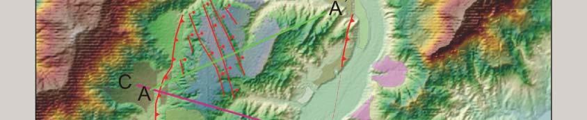
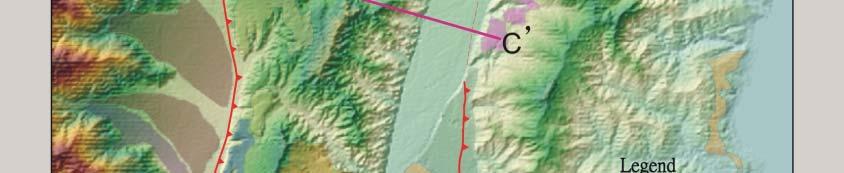
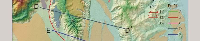
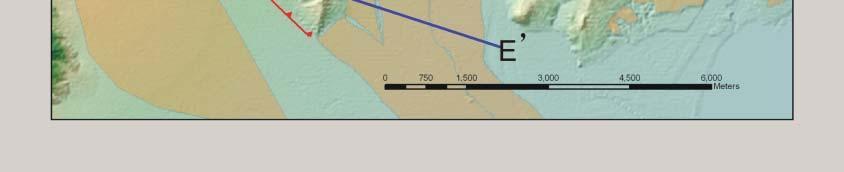
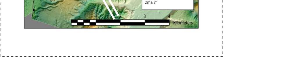
12 Fig.8 ProfileA, B, C, D, E was label on the surface topography image with sunlight shade.


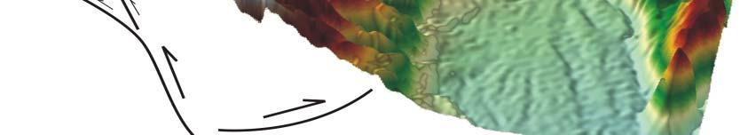
13 A A Fig.9 Profile A: 3- D model and subsurface structure sketch map. B B Fig.10 Profile B: 3- D model and subsurface structure sketch map.


14 C C Fig.11 Profile C: 3- D model and subsurface structure sketch map.


15 D D Fig.12 Profile D: 3- D model and subsurface structure sketch map.


16 E E Fig.13 Profile E: 3- D model and subsurface structure sketch map.
depression above scarp scarp
 1 LAB 1: FIELD TRIP TO McKINLEYVILLE AND MOUTH OF THE MAD RIVER OBJECTIVES: a. to look at geomorphic and geologic evidence for large scale thrust-faulting of young sediments in the Humboldt Bay region
Structural Geology Lab. The Objectives are to gain experience
 Geology 2 Structural Geology Lab The Objectives are to gain experience 1. Drawing cross sections from information given on geologic maps. 2. Recognizing folds and naming their parts on stereoscopic air
Geoscience 001 Fall Rock Identification and Contextual Interpretation
 Geoscience 00 Fall 2005 Rock Identification and Contextual Interpretation The purpose of this week s lab is to gain some more experience and practice in identifying rocks and then interpreting the geologic
Answers: Internal Processes and Structures (Isostasy)
") Answers: Internal Processes and Structures (Isostasy) 1. Analyse the adjustment of the crust to changes in loads associated with volcanism, mountain building, erosion, and glaciation by using the concept
Answers: Internal Processes and Structures (Isostasy) 1. Analyse the adjustment of the crust to changes in loads associated with volcanism, mountain building, erosion, and glaciation by using the concept
UNIT 3 GEOLOGY VOCABULARY FLASHCARDS THESE KEY VOCABULARY WORDS AND PHRASES APPEAR ON THE UNIT 3 CBA
 UNIT 3 GEOLOGY VOCABULARY FLASHCARDS THESE KEY VOCABULARY WORDS AND PHRASES APPEAR ON THE UNIT 3 CBA A map that shows Earth s Topographic Map surface topography, which is Earth s shape and features Contour
Chapter 2. Earthquake and Damage
 EDM Report on the Chi-Chi, Taiwan Earthquake of September 21, 1999 2.1 Earthquake Fault 2.1.1 Tectonic Background The island of Taiwan is located in the complex junction where the Eurasian and Philippine
GLY 155 Introduction to Physical Geology, W. Altermann. Press & Siever, compressive forces. Compressive forces cause folding and faulting.
 Press & Siever, 1995 compressive forces Compressive forces cause folding and faulting. faults 1 Uplift is followed by erosion, which creates new horizontal surface. lava flows Volcanic eruptions cover
Deformation of Rocks. Orientation of Deformed Rocks
 Deformation of Rocks Folds and faults are geologic structures caused by deformation. Structural geology is the study of the deformation of rocks and its effects. Fig. 7.1 Orientation of Deformed Rocks
UNDERSTANDING GEOLOGIC M APS
 Name: Lab Section: work in groups, but each person turns in his/her own GEOSCIENCE 001 L AB UNDERSTANDING GEOLOGIC M APS Geologic maps are colorful and even beautiful, but they also contain an amazing
In this lab, we will study and analyze geologic maps from a few regions, including the Grand Canyon, western Wyoming, and coastal California.
 Name: Lab Section: work in groups, but each person turns in his/her own GEOSCIENCE 001 LAB UNDERSTANDING GEOLOGIC MAPS Geologic maps are colorful and even beautiful, but they also contain an amazing amount
Lab 7: STRUCTURAL GEOLOGY FOLDS AND FAULTS
 Lab 7: STRUCTURAL GEOLOGY FOLDS AND FAULTS This set of labs will focus on the structures that result from deformation in earth s crust, namely folds and faults. By the end of these labs you should be able
Crustal Deformation. Earth Systems 3209
 Crustal Deformation Earth Systems 3209 Crustal Deformation pg. 415 Refers to all changes in the original form and/or size of a rock body. May also produce changes in the location and orientation of rocks.
Structural Geology Lab. The Objectives are to gain experience
 Geology 2 Structural Geology Lab The Objectives are to gain experience 1. Drawing cross sections from information given on geologic maps. 2. Recognizing folds and naming their parts on stereoscopic air
Strike-Slip Faults. ! Fault motion is parallel to the strike of the fault.
 Strike-Slip Faults! Fault motion is parallel to the strike of the fault.! Usually vertical, no hanging-wall/footwall blocks.! Classified by the relative sense of motion. " Right lateral opposite block
NAME HOMEWORK ASSIGNMENT #3 MATERIAL COVERS CHAPTERS 8, 9, 10, 11
 NAME HOMEWORK ASSIGNMENT #3 MATERIAL OVERS HAPTERS 8, 9, 10, 11 Assignment is due the beginning of the class period on November 23, 2004. Answers for each chapter will be discussed in class, as Exam #3
Chapter 10: Deformation and Mountain Building. Fig. 10.1
 Chapter 10: Deformation and Mountain Building Fig. 10.1 OBJECTIVES Describe the processes of rock deformation and compare and contrast ductile and brittle behavior in rocks. Explain how strike and dip
Staple this part to part one of lab 6 and turn in. Lab 6, part two: Structural geology (analysis)
") Geology 101 Staple this part to part one of lab 6 and turn in Lab 6, part two: Structural geology (analysis) Recall that the objective of this lab is to describe the geologic structures of Cougar Mountain
Geology 101 Staple this part to part one of lab 6 and turn in Lab 6, part two: Structural geology (analysis) Recall that the objective of this lab is to describe the geologic structures of Cougar Mountain
Description of faults
 GLG310 Structural Geology Description of faults Horizontal stretch Crustal thickness Regional elevation Regional character Issues Normal Thrust/reverse Strike-slip >1 1 in one direction and < 1 in
R.Suhasini., Assistant Professor Page 1
 UNIT I PHYSICAL GEOLOGY Geology in civil engineering branches of geology structure of earth and its composition weathering of rocks scale of weathering soils - landforms and processes associated with river,
Section 3 Deforming Earth s Crust
 Section 3 Deforming Earth s Crust Key Concept Tectonic plate motions deform Earth s crust. Deformation causes rock layers to bend and break and causes mountains to form. What You Will Learn Stress is placed
Geologic Mapping Regional Tournament Trial Event
 Geologic Mapping Regional Tournament Trial Event A TEAM OF UP TO: 2 Team Name AVAILABLE TIME: 50 min Required Materials: Each team MUST have a protractor, ruler, non-programmable calculator, colored pencils,
GEOL 02: Historical Geology Lab 14: Topographic Maps. Name: Date:
 GEOL 02: Historical Geology Lab 14: Topographic Maps Name: Date: A topographic map is a two dimensional (flat) representation (model) of a three dimensional land surface (landscape). It shows landforms
Chapter 3. Geology & Tectonics
 Chapter 3 Geology & Tectonics 3.1 Geology The general geological features of Indonesia are shown in Figure 3.1. The basement formation is metamorphic and it is intruded with plutonic formations. They are
Bonn, Germany MOUTAZ DALATI. General Organization for Remote Sensing ( GORS ), Syria Advisor to the General Director of GORS,
, Syria Advisor to the General Director of GORS,") Bonn, Germany Early Warning System is needed for Earthquakes disaster mitigation in Syria Case Study: Detecting and Monitoring the Active faulting zones along the Afro-Arabian-Syrian Rift System MOUTAZ
Bonn, Germany Early Warning System is needed for Earthquakes disaster mitigation in Syria Case Study: Detecting and Monitoring the Active faulting zones along the Afro-Arabian-Syrian Rift System MOUTAZ
Continental Landscapes
 Continental Landscapes Landscape influenced by tectonics, climate & differential weathering Most landforms developed within the last 2 million years System moves toward an equilibrium Continental Landscapes
Convergent plate boundary.
 Crustal Deformation Convergent plate boundary http://my.execpc.com/~acmelasr/mountains/geogramsnf.html Plate Tectonic Settings and Magma Where plates CONVERGE, water is driven off the subducting plate,
Lab 6: Plate tectonics, structural geology and geologic maps
 Geology 103 Name(s): Lab 6: Plate tectonics, structural geology and geologic maps Objective: To show the effects of plate tectonics on a large-scale set of rocks and to reconstruct the geological history
BALOCHISTAN FOLDBELT BASIN
 INTRODUCTION BALOCHISTAN FOLDBELT BASIN The Kharan-3 block is located in the Kharan Trough of Balochistan Basin. GEOLOGICAL SETTING The Balochistan Province is an Upper Cretaceous to Recent structurally
4 Deforming the Earth s Crust
 CHAPTER 7 4 Deforming the Earth s Crust SECTION Plate Tectonics BEFORE YOU READ After you read this section, you should be able to answer these questions: What happens when rock is placed under stress?
Plate Tectonics. entirely rock both and rock
 Plate Tectonics I. Tectonics A. Tectonic Forces are forces generated from within Earth causing rock to become. B. 1. The study of the origin and arrangement of Earth surface including mountain belts, continents,
Captain s Tryouts 2017
 Captain s Tryouts 2017 Dynamic Planet Test Written by: Araneesh Pratap (Chattahoochee High School) Name: Date: Answer all questions on the answer sheet. Point values are given next to each question or
Chapter 15 Structures
 Chapter 15 Structures Plummer/McGeary/Carlson (c) The McGraw-Hill Companies, Inc. TECTONIC FORCES AT WORK Stress & Strain Stress Strain Compressive stress Shortening strain Tensional stress stretching
Team Name. Name(s) SSSS Unome Geologic Mapping Test Packet p1
 SSSS Unome Geologic Mapping Test Packet p1") Scioly Summer Study Session 2018-2019 Geologic Mapping Test Packet Written by Unome Instructions 1) This test is based on the 2016 rules for Geologic Mapping. 2) This test is out of 115 points. Questions
Scioly Summer Study Session 2018-2019 Geologic Mapping Test Packet Written by Unome Instructions 1) This test is based on the 2016 rules for Geologic Mapping. 2) This test is out of 115 points. Questions
Stress and Strain. Stress is a force per unit area. Strain is a change in size or shape in response to stress
 Geologic Structures Geologic structures are dynamically-produced patterns or arrangements of rock or sediment that result from, and give information about, forces within the Earth Produced as rocks change
Use a highlighter to mark the most important parts, or the parts. you want to remember in the background information.
 P a g e 1 Name A Fault Model Purpose: To explore the types of faults and how they affect the geosphere Background Information: A fault is an area of stress in the earth where broken rocks slide past each
(1) Identify 5 major principles of relative dating? For each principle, describe how you tell what is younger and what is older.
 Identify 5 major principles of relative dating? For each principle, describe how you tell what is younger and what is older.") Things to Know - Third GLG101Exam Page 1 Important Note: This is not everything you need to know or study. However, it provides you with a relatively comprehensive list of questions to help you study.
Things to Know - Third GLG101Exam Page 1 Important Note: This is not everything you need to know or study. However, it provides you with a relatively comprehensive list of questions to help you study.
GEOLOGIC MAPS PART II
 EARTH AND ENVIRONMENT THROUGH TIME LABORATORY - EES 1005 LABORATORY FIVE GEOLOGIC MAPS PART II Introduction Geologic maps of orogenic belts are much more complex than maps of the stable interior. Just
Part I. PRELAB SECTION To be completed before labs starts:
 Student Name: Physical Geology 101 Laboratory #13 Structural Geology II Drawing and Analyzing Folds and Faults Grade: Introduction & Purpose: Structural geology is the study of how geologic rock units
ESTIMATION OF SEDIMENT THICKNESS BY USING MICROTREMOR OBSERVATIONS AT PALU CITY, INDONESIA. Pyi Soe Thein. 11 November 2013
 ESTIMATION OF SEDIMENT THICKNESS BY USING MICROTREMOR OBSERVATIONS AT PALU CITY, INDONESIA By Pyi Soe Thein 11 November 2013 Outlines Introduction Research objectives Research analyses Microtremor Single
ANOTHER MEXICAN EARTHQUAKE! Magnitude 7.1, Tuesday Sept. 19, 2017
 ANOTHER MEXICAN EARTHQUAKE! Magnitude 7.1, Tuesday Sept. 19, 2017 Why is there no oceanic crust older than 200 million years? SUBDUCTION If new oceanic crust is being continuously created along the earth
Lecture 9 faults, folds and mountain building
 Lecture 9 faults, folds and mountain building Rock deformation Deformation = all changes in size, shape, orientation, or position of a rock mass Structural geology is the study of rock deformation Deformation
Topographic Maps and Landforms Geology Lab
 Topographic Maps and Landforms Geology Lab Ray Rector: Instructor Today s Lab Activities 1) Discussion of Last Week s Lab 2) Lecture on Topo Maps and Elevation Contours 3) Construct Topographic Maps and
Deformation: Modification of Rocks by Folding and Fracturing
 CHAPTER 7 Deformation: Modification of Rocks by Folding and Fracturing Chapter Summary A geologic map is a scientific model of rock formations that are exposed on the Earth s surface showing outcrops,
Structural Analysis and Tectonic Investigation of Chamshir Dam Site, South West Zagros
 Open Journal of Geology, 2015, 5, 136-143 Published Online March 2015 in SciRes. http://www.scirp.org/journal/ojg http://dx.doi.org/10.4236/ojg.2015.53013 Structural Analysis and Tectonic Investigation
PALEOGEOGRAPHY of NYS. Definitions GEOLOGIC PROCESSES. Faulting. Folding 9/6/2012. TOPOGRAPHIC RELIEF MAP of NYS GRADATIONAL TECTONIC
 TOPOGRAPHIC RELIEF MAP of NYS PALEOGEOGRAPHY of NYS Prof. Anthony Grande AFG 2012 Definitions GEOLOGIC PROCESSES Geography: study of people living on the surface of the earth. Geology: the scientific study
Mountains are then built by deforming crust: Deformation & Mountain Building. Mountains form where stresses are high!
 Deformation & Mountain Building Where are mountains located? Deformation and Folding Mountain building Mountains form where stresses are high! Mountains form at all three types of plate boundaries where
Plate Tectonics - Demonstration
 Name: Reference: Prof. Larry Braile - Educational Resources Copyright 2000. L. Braile. Permission granted for reproduction for non-commercial uses. http://web.ics.purdue.edu/~braile/indexlinks/educ.htm
Faults, folds and mountain building
 Faults, folds and mountain building Mountain belts Deformation Orogens (Oro = Greek all changes for mountain, in size, shape, genesis orientation, = Greek for or formation) position of a rock mass Structural
CE6301 ENGINEERING GEOLOGY UNIT I 2 MARKS
 YEAR : II SEMESTER : III DEPARTMENT : CIVIL CE6301 ENGINEERING GEOLOGY UNIT I 1. What is Physical weathering? 2. Define Stratigraphy and Palaeontology? 3. What is meant by chemical weathering 4. Describe
Not For Web Reproduction. New Topic: TECTONIC GEOMORPHOLOGY. Tectonic Geomorphology vs. Structural Geomorphology
 New Topic: TECTONIC GEOMORPHOLOGY Tectonic Geomorphology vs. Structural Geomorphology Late Cenozoic Tectonic Movement vs. Late Cenozoic Erosion of Older Structures Geologic Time Scale Not For Web Reproduction
LAB 1: ORIENTATION OF LINES AND PLANES
 LAB 1: ORIENTATION OF LINES AND PLANES Read the introductory section, chapter 1, pages 1-3, of the manual by Rowland et al (2007) and make sure you understand the concepts of bearing, strike, dip, trend,
Name. GEOL.5220 Structural Geology Faults, Folds, Outcrop Patterns and Geologic Maps. I. Properties of Earth Materials
 I. Properties of Earth Materials GEOL.5220 Structural Geology Faults, Folds, Outcrop Patterns and Geologic Maps Name When rocks are subjected to differential stress the resulting build-up in strain can
Downloaded from Downloaded from
 IV SEMESTER BACK-PAPER EXAMINATION-2004 Q. [1] [a] Describe internal structure of the earth with a neat sketch. Write down the major land forms and their characteristics on the earth surface. [8] [b] What
Age and correlation of basement geology of Aurora, Rizal and Zambales areas, Luzon, Philippines
 Age and correlation of basement geology of Aurora, Rizal and Zambales areas, Luzon, Philippines Shigeyuki SUZUKI 1, Keisuke ISHIDA 2, Graciano P. YUMUL, Jr. 3 and Carla B. DIMALANTA 3 1 Department of Earth
Earth Science, (Tarbuck/Lutgens) Chapter 10: Mountain Building
 Chapter 10: Mountain Building") Earth Science, (Tarbuck/Lutgens) Chapter 10: Mountain Building 1) A(n) fault has little or no vertical movements of the two blocks. A) stick slip B) oblique slip C) strike slip D) dip slip 2) In a(n) fault,
Earth Science, (Tarbuck/Lutgens) Chapter 10: Mountain Building 1) A(n) fault has little or no vertical movements of the two blocks. A) stick slip B) oblique slip C) strike slip D) dip slip 2) In a(n) fault,
Directed Reading. Section: Types of Maps
 Skills Worksheet Directed Reading Section: Types of Maps 1. What are some of the characteristics of an area shown on maps used by Earth scientists? a. types of animals, types of plants, types of minerals
How mountains are made. We will talk about valleys (erosion and weathering later)
") How mountains are made We will talk about valleys (erosion and weathering later) http://www.ilike2learn.com/ilike2learn/mountainmaps/mountainranges.html Continent-continent plate convergence Less dense,
How mountains are made We will talk about valleys (erosion and weathering later) http://www.ilike2learn.com/ilike2learn/mountainmaps/mountainranges.html Continent-continent plate convergence Less dense,
Landforms and Rock Structure
 Landforms and Rock Structure Rock Structure as a Landform Control Landforms of Horizontal Strata and Coastal Plains Landforms of Warped Rock Layers Landforms Developed on Other Land-Mass Types Landforms
Description of faults
 GLG310 Structural Geology Description of faults Horizontal stretch Crustal thickness Regional elevation Regional character Issues Normal Thrust/reverse Strike-slip >1 1 in one direction and < 1 in
4 Deforming the Earth s Crust
 CHAPTER 7 4 Deforming the Earth s Crust SECTION Plate Tectonics BEFORE YOU READ After you read this section, you should be able to answer these questions: What happens when rock is placed under stress?
Geologic Mapping Invitational Trial Event
 Geologic Mapping Invitational Trial Event A TEAM OF UP TO: 2 Team Name AVAILABLE TIME: 50 min Required Materials: Each team MUST have a protractor, ruler, non-programmable calculator, colored pencils,
Determination of fold and fault geometries from faultrelated fold study : A case of Hukou fault in NW Taiwan
 1 Determination of fold and fault geometries from faultrelated fold study : A case of Hukou fault in NW Taiwan Presenter : Dwi Febriana Rochmah Adviser : Wen-Jeng Huang Date : 2016/10/20 Motivation Fold
Structural Geology and Geology Maps Lab
 Structural Geology and Geology Maps Lab Mesa College Geology 101 Lab Ray Rector: Instructor Structural Geology Lab Pre-Lab Resources Pre-Lab Internet Links 1) Fundamentals of Structural Geology 2) Visualizing
Do Now: Vocabulary: Objectives. Vocabulary: 1/5/2016. Wegener? (Can they move?) the idea that continents have moved over time?
 the idea that continents have moved over time?") Do Now: 1. Who was Alfred Wegener? 2. What was Pangaea? 3. Are continents fixed? (Can they move?) 4. What evidence supports the idea that continents have moved over time? Objectives What evidence suggests
Do Now: 1. Who was Alfred Wegener? 2. What was Pangaea? 3. Are continents fixed? (Can they move?) 4. What evidence supports the idea that continents have moved over time? Objectives What evidence suggests
Directed Reading. Section: How Mountains Form MOUNTAIN RANGES AND SYSTEMS. Skills Worksheet
 Skills Worksheet Directed Reading Section: How Mountains Form 1. How high is Mount Everest? a. about 1980 km above sea level b. more than 8 km below sea level c. more than 8 km above sea level d. more
Forces in Earth s Crust
 Forces in Earth s Crust (pages 180 186) Types of Stress (page 181) Key Concept: Tension, compression, and shearing work over millions of years to change the shape and volume of rock. When Earth s plates
10. Paleomagnetism and Polar Wandering Curves.
 Map of ocean floor Evidence in Support of the Theory of Plate Tectonics 10. Paleomagnetism and Polar Wandering Curves. The Earth's magnetic field behaves as if there were a bar magnet in the center of
Introduction To Plate Tectonics Evolution. (Continents, Ocean Basins, Mountains and Continental Margins)
") Introduction To Plate Tectonics Evolution (Continents, Ocean Basins, Mountains and Continental Margins) Geo 386 (Arabian Shield Course) Dr. Bassam A. A. Abuamarah Mohanna G E O 3 8 6 A R A B I A N G E
Introduction To Plate Tectonics Evolution (Continents, Ocean Basins, Mountains and Continental Margins) Geo 386 (Arabian Shield Course) Dr. Bassam A. A. Abuamarah Mohanna G E O 3 8 6 A R A B I A N G E
UNIT 10 MOUNTAIN BUILDING AND EVOLUTION OF CONTINENTS
 UNIT 10 MOUNTAIN BUILDING AND EVOLUTION OF CONTINENTS ROCK DEFORMATION Tectonic forces exert different types of stress on rocks in different geologic environments. STRESS The first, called confining stress
Siva Bharatha Murthy. T Page 4.31
 Importance of Geological Structures: The physical properties of rocks, mineral and other materials of civil engineering, like textures, grain size are very important for a civil engineer. Similarly the
GCE AS/A level 1211/01 GEOLOGY GL1 Foundation Unit
 Surname Centre Number Candidate Number Other Names 2 GCE AS/A level 1211/01 GEOLOGY GL1 Foundation Unit S15-1211-01 A.M. MONDAY, 11 May 2015 1 hour For s use Question Maximum Mark 1. 15 2. 14 Mark Awarded
FINAL EXAM Crustal Deformation CONVERGE DIVERGENT PLATES MANTLE PLUMES FLUX BASALTIC GRANITIC
 Crustal Deformation Reading: Chapter 10 Pages 283-294 FINAL EXAM 8 to 10 AM, THURSDAY DEC. 6 HERE: Natural Science 101 BRING A SCAN TRON TURN IN YOUR REVIEW QUESTIONS BEFORE THE TEST, PICK UP WHEN YOU
Geologic Structures. Changes in the shape and/or orientation of rocks in response to applied stress
 Geologic Structures Changes in the shape and/or orientation of rocks in response to applied stress Figure 15.19 Can be as big as a breadbox Or much bigger than a breadbox Three basic types Fractures >>>
COSMORPHOLOGY - May 2009
 Name COSMORPHOLOGY - May 2009 Geologic landforms Purpose: By studying aerial photographs you will learn to identify different kinds of geologic features based on their different morphologies and learn
3/5/05 Dr. Stewart 1
 I. Physiography of Appalachian Mountains A. Introduction 1. These mountains extend from NE Canada to Georgia 2. They are the remains of a deeply eroded, ancient mountain chain once larger than the Himalayans
Ge Problem Set 1
 Ge 101 2012 Problem Set 1 This problem set covers basic techniques in structural geology, geomorphology and the construction of cross sections. Questions 2 and 3 are simple exercises; 1 and 4 are reallife
Earth s Dynamic Surface
 Earth s Dynamic Surface Shaping Earth s Surface What do you think? Read the two statements below and decide whether you agree or disagree with them. Place an A in the Before column if you agree with the
What type of land feature is located at Point A? A Cliff B Delta C Mountain D Valley
 1 What type of land feature is located at Point A? A Cliff B Delta C Mountain D Valley Alfred Wegener s theory of continental drift was 2 not accepted by scientists when the theory was first proposed.
How to Build a Mountain and other Geologic Structures. But first a short review
 How to Build a Mountain and other Geologic Structures But first a short review Where do we see deep earthquakes? What is happening there? What can happen at a plate boundary? 1. Plates can move apart
Forces That Shape Earth. How do continents move? What forces can change rocks? How does plate motion affect the rock cycle?
 Forces That Shape Earth How do continents move? What forces can change rocks? How does plate motion affect the rock cycle? Plate Motion Mountain ranges are produced by plate tectonics. The theory of plate
Geology : Embedded Inquiry
 Geology : Embedded Inquiry Conceptual Strand Understandings about scientific inquiry and the ability to conduct inquiry are essential for living in the 21 st century. Guiding Question What tools, skills,
ESTIMATES OF HORIZONTAL DISPLACEMENTS ASSOCIATED WITH THE 1999 TAIWAN EARTHQUAKE
 ESTIMATES OF HORIZONTAL DISPLACEMENTS ASSOCIATED WITH THE 1999 TAIWAN EARTHQUAKE C. C. Chang Department of Surveying and Mapping Engineering Chung Cheng Institute of Technology, Taiwan, ROC ABSTRACT A
A. Refer to Appendix F in back of lab manual for list of commonly used geologic map symbols
 Structural Geology Lab 2: Outcrop Patterns and Structure Contours I. Geologic Map Symbols A. Refer to Appendix F in back of lab manual for list of commonly used geologic map symbols 1. Emphasis: a. strike
Instructor s Manual Chapter 10. Deformation, Mountain Building, and the Continents
 Chapter 10 Table of Contents Chapter Outline Learning Outcomes Chapter Summary Lecture Suggestions Enrichment Topics Common Misconceptions Consider This Key Terms Internet Sites, Videos, Software, and
A physical feature of the Earth s surface
 Earth s Landforms A physical feature of the Earth s surface A physical feature of the Earth s surface LANDFORM Highest of Earth s physical features Highest of Earth s physical features MOUNTAIN Low area
24. Ocean Basins p
 24. Ocean Basins p. 350-372 Background The majority of the planet is covered by ocean- about %. So the majority of the Earth s crust is. This crust is hidden from view beneath the water so it is not as
Surface Processes Focus on Mass Wasting (Chapter 10)
") Surface Processes Focus on Mass Wasting (Chapter 10) 1. What is the distinction between weathering, mass wasting, and erosion? 2. What is the controlling force in mass wasting? What force provides resistance?
Surface Processes Focus on Mass Wasting (Chapter 10) 1. What is the distinction between weathering, mass wasting, and erosion? 2. What is the controlling force in mass wasting? What force provides resistance?
Does the SDCP need inputs from geology?
 The British Geological Survey s Experience and Expertise in Supporting Projects such as the Sirte Depression Connection Project David Ovadia Director of International Kingsley Dunham Centre Keyworth Nottingham
Earth s Tectonic Plates
 MASTER 49 6.2 3.7 5.4 Philippine Pacific 5.4 North American Juan de Fuca Caribbean Cocos 10.0 9.2 2.3 2.5 2.3 1.8 3.0 Indian-Australian 10.5 7.1 17.2 16.8 6.0 Nazca South American 11.1 10.3 7.3 3.7 7.5
LAB 5: LANDSLIDE RECOGNITION AND MAPPING
 Geology 350 1 LAB 5: LANDSLIDE RECOGNITION AND MAPPING OBJECTIVES: a. to learn to recognize and classify landslides on airphotos and topographic maps b. to learn to recognize landslide topography on topographic
Questions and Topics
 Plate Tectonics and Continental Drift Questions and Topics 1. What are the theories of Plate Tectonics and Continental Drift? 2. What is the evidence that Continents move? 3. What are the forces that
Sequence Stratigraphy. Historical Perspective
 Sequence Stratigraphy Historical Perspective Sequence Stratigraphy Sequence Stratigraphy is the subdivision of sedimentary basin fills into genetic packages bounded by unconformities and their correlative
Determination of uplift rates of fluvial terraces across the Siwaliks Hills, Himalayas of central Nepal
 Determination of uplift rates of fluvial terraces across the Siwaliks Hills, Himalayas of central Nepal Martina Böhme Institute of Geology, University of Mining and Technology, Freiberg, Germany Abstract.
GEOLOGY MEDIA SUITE Chapter 13
 UNDERSTANDING EARTH, SIXTH EDITION GROTZINGER JORDAN GEOLOGY MEDIA SUITE Chapter 13 Earthquakes 2010 W.H. Freeman and Company Three different types of seismic waves are recorded by seismographs Key Figure
Plates & Boundaries The earth's continents are constantly moving due to the motions of the tectonic plates.
 Plates & Boundaries The earth's continents are constantly moving due to the motions of the tectonic plates. As you can see, some of the plates contain continents and others are mostly under the ocean.
USU 1360 TECTONICS / PROCESSES
 USU 1360 TECTONICS / PROCESSES Observe the world map and each enlargement Pacific Northwest Tibet South America Japan 03.00.a1 South Atlantic Arabian Peninsula Observe features near the Pacific Northwest
PHYSICAL GEOGRAPHY: An overview. Definitions. Faulting. Folding GEOLOGIC PROCESSES 9/17/2013 TOPOGRAPHIC RELIEF
 TOPOGRAPHIC RELIEF PHYSICAL GEOGRAPHY: An overview Prof. Anthony Grande AFG 0913 2 Definitions GEOLOGIC PROCESSES Geography: Study of people living on the surface of the earth. Geology: the study of the
Layers of the Earth Date: SWABT: Identify and describe the layers of the Earth and their characteristics
 Layers of the Earth SWABT: Identify and describe the layers of the Earth and their characteristics CRUST Composition: Thickness: State of Matter: : Mostly Basalt : Mostly Granite : Crust and Upper Mantle
Geology 101 Lab Worksheet: Geologic Structures
 Name: Geology 101 Lab Worksheet: Geologic Structures Refer to the Geologic Structures Lab for the information you need to complete this worksheet (http://commons.wvc.edu/rdawes/g101ocl/labs/structurelab.html).
Geo-hazard Potential Mapping Using GIS and Artificial Intelligence
 Geo-hazard Potential Mapping Using GIS and Artificial Intelligence Theoretical Background and Uses Case from Namibia Andreas Knobloch 1, Dr Andreas Barth 1, Ellen Dickmayer 1, Israel Hasheela 2, Andreas