Earthquake Hazards in Douglas County
|
|
|
- Darren Hodge
- 5 years ago
- Views:
Transcription
1 Earthquake Hazards in Douglas County Craig M. depolo Nevada Bureau of Mines and Geology Nevada Hazard Mitigation Planning Committee August 9, 2012

2
3 Earthquake Truths The consequences of bad earthquakes to unprepared communities are unacceptable. We know how to plan for, prepare for, and mitigate against disastrous earthquake effects. We know how to minimize injuries and property loss.
4 The Earthquake Hazard Earthquake faults occur throughout Nevada, and potential losses from earthquakes are high for many communities. NBMG Map 167, Quaternary Faults in Nevada, is available as a poster and as an interactive map (Open-File Report 09-9) on line at You can use it to locate your home or business.
 Active faults are nearly everywhere in Nevada. A magnitude 6.0 earthquake can occur anywhere in Nevada. 50 km www.")
5 Age of Latest Fault Rupture < 150 years (historical) < 15,000 years < 130,000 years < 750,000 years < 1,800,000 years (Quaternary) Active faults are nearly everywhere in Nevada. A magnitude 6.0 earthquake can occur anywhere in Nevada. 50 km

6
 Topographic base map from the")
7 NBMG Open-File Report 09-9 Example: Genoa fault (last ruptured approximately 300ish years ago) Topographic base map from the USGS.

8 As you blow up the view, the computer automatically picks a more detailed USGS topographic base map.
9 As you blow up the view, the computer automatically picks a more detailed USGS topographic base map.
10 Faults are shown as 1,000-meter-wide swaths, here on an aerial photograph base.

11
12 Faults are shown as 1,000-meter-wide swaths, here on an aerial photograph base.
13 Faults are shown as 1,000-meter-wide swaths, here on a topographic map base.
, the slip rate (in millimeters per year), and other")
14 Use the information icon to find the age of latest rupture (in years), the slip rate (in millimeters per year), and other information.

15 The USGS integrates (1) fault, (2) earthquake, and (3) geodetic data into its probabilistic seismic hazard analysis.

16 Active faults are present throughout Nevada, including Douglas County.
 Earthquakes have occurred")
17 Wells 21 Feb 08 M = 6.0 (2) Earthquakes have occurred throughout Nevada.
18
19
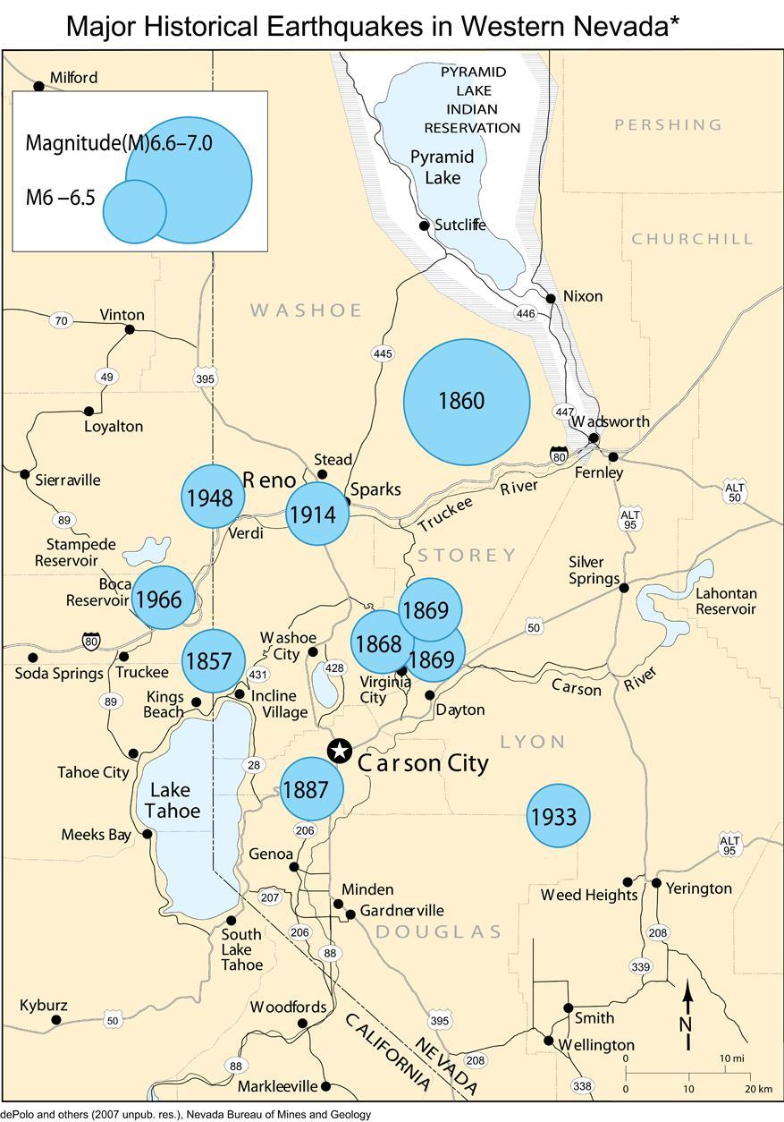
20 Historical Earthquakes 1887 Carson Valley earthquake (M6.3) 1932 Cedar Mountain earthquake (M7.1) 1933 Wabuska earthquake (M6.0) 1994 Double Spring Flat earthquake (M5.8)
 Geodetic data indicate that the Nevada is gaining")

21 Kreemer et al. (2012) Geodetic data indicate that the Nevada is gaining about 0.2 acre of area per year through crustal extension, and that western Nevada is accommodating ~20% of the North American- Pacific plate interaction.


22 Uncertainty is high in areas with few geodetic GPS data points (areas in blue on this map).


23 West of the San Andreas fault in California, the Pacific Plate is moving northwest relative to the North American Plate. Kreemer et al. (2012)
 along normal faults. Kreemer et al.")
24 Western Nevada is accommodating ~20% of the North American-Pacific plate interaction, mostly along rightlateral strike-slip faults and obliqueslip normal faults. Extension is occurring mostly in western and central Nevada (and along the Wasatch front in Utah) along normal faults. Kreemer et al. (2012)

25 In Nevada, much of the right-lateral shear between the North American and Pacific plates occurs along northwest-striking strike-slip faults of the Walker Lane. Extension largely is accommodated along N- to NE-striking, basin-bounding normal faults. Walker Lane
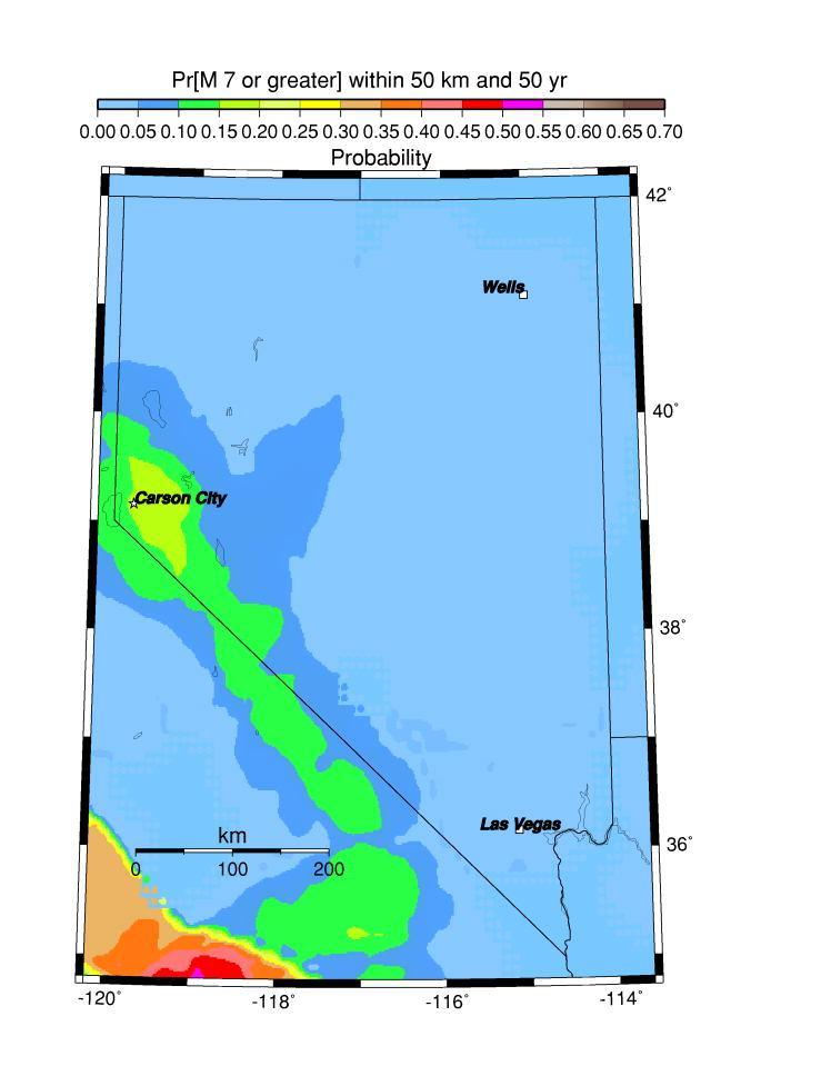
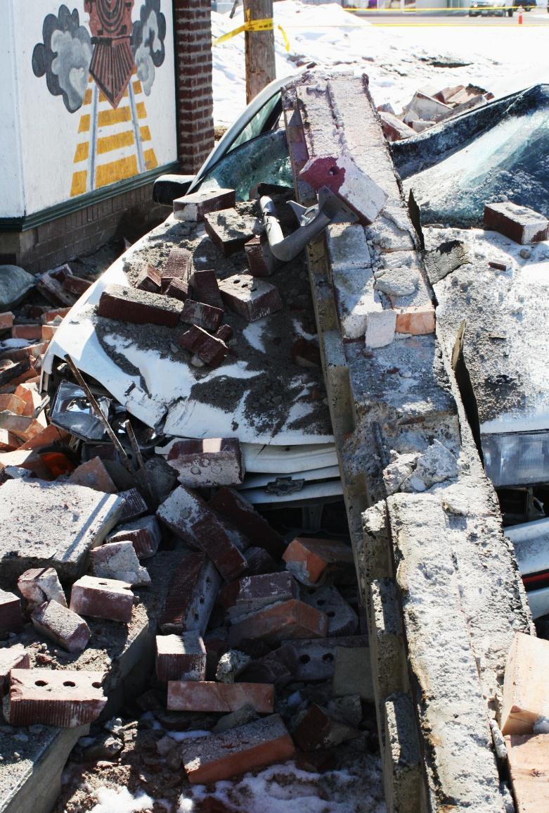
26 The hazard: expressed in terms of probability of an earthquake of a given magnitude occurring within 50 years and within 50 km (31 miles) of the community. % Probability of > or = magnitude Community Dayton >90 ~ Carson City >90 ~ Minden >90% ~80% 67% 50-60% 10-12% Reno >90 ~ Incline Village >90 ~ Stateline >90 ~ Fallon ~ Las Vegas ~ <0.5 Elko ~ Wells ~ Laughlin ~ <0.5 Data are from the USGS at Values for magnitude 5.5 are extrapolated between 5.0 and 6.0.
27 Earthquake faults occur throughout Nevada, and potential losses from earthquakes are high for many communities. NBMG Open-File Report 09-8, Estimated Losses from Earthquakes near Nevada Communities, demonstrates that the consequences of earthquakes can be huge in Nevada, particularly if individuals are not prepared. HAZUS scenarios for magnitude 5.0, 5.5, 6.0, 6.5, and 7.0 earthquakes near 38 communities in Nevada
28 Earthquake RISKS in Nevada NBMG OFR-09-8 used the Federal Emergency Management Agency s loss-estimation model, HAZUS-MH, and the U.S. Geological Survey s probabilistic seismic hazard analysis.


29 These loss estimates are useful in hazard-mitigation planning, in building scenarios for emergency response and recovery exercises, and in helping emergency managers and the Governor make decisions on official disaster declarations after an actual earthquake.
30 Uncertainties in the location of epicenters, depths, and magnitude, combined with changing population, uncertainties in local effects (soil and rock types, assumptions about attenuation, basin geometry, liquefaction potential, and directivity), make loss estimates generally consistent within one order of magnitude (a factor of 10), although experience with urban earthquakes in the US has generally yielded numbers within a factor of 2 or 3 of the actual damages.

31 2008 Mw 6.0 Wells Earthquake
32 HAZUS estimates for total economic loss from a magnitude 6.0 earthquake and probability of an earthquake of this magnitude or greater occurring within 50 years and within 31 mi (50 km) of the community. Community Total Economic Loss Probability M6 in 50 yrs within 31 mi Las Vegas $7.2 billion 12% Reno $1.9 billion 67% Carson City $650 million 70% Stateline $590 million 60-70% Minden $340 million 67% Elko $160 million 10-15% Fallon $110 million 35% Wells $30 million 9% Total economic loss is from HAZUS. Probabilities are from the USGS at


33 The probability of a magnitude 6.0 earthquake occurring within 50 km of Wells, Nevada within the next 50 years is approximately 9%. It happened on 21 February C. depolo photo

34 The probability of a magnitude 6.0 earthquake occurring within 50 km of Carson City within the next 50 years is approximately 70%, 7.8 times higher than for Wells.
35
36
37 Earthquake faults occur throughout Nevada, and potential losses from earthquakes are high for many communities. The consequences of earthquakes can be huge in Nevada, particularly if individuals are not prepared. A. Be prepared to respond. B. Mitigate structural risks, largely through building codes and avoiding faults and areas of liquefaction. C. Mitigate nonstructural risks.
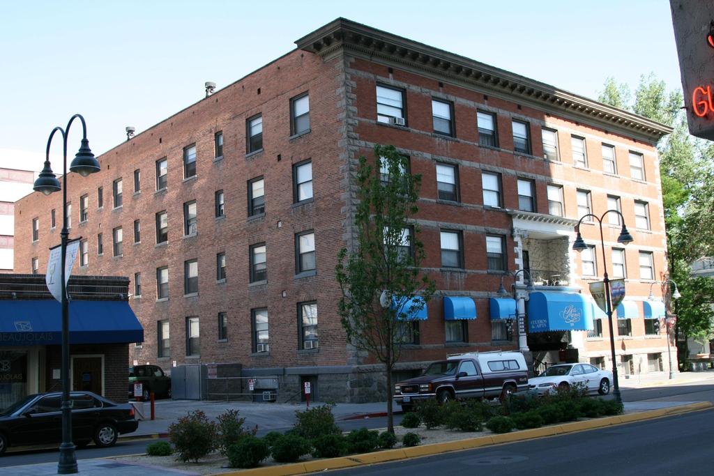
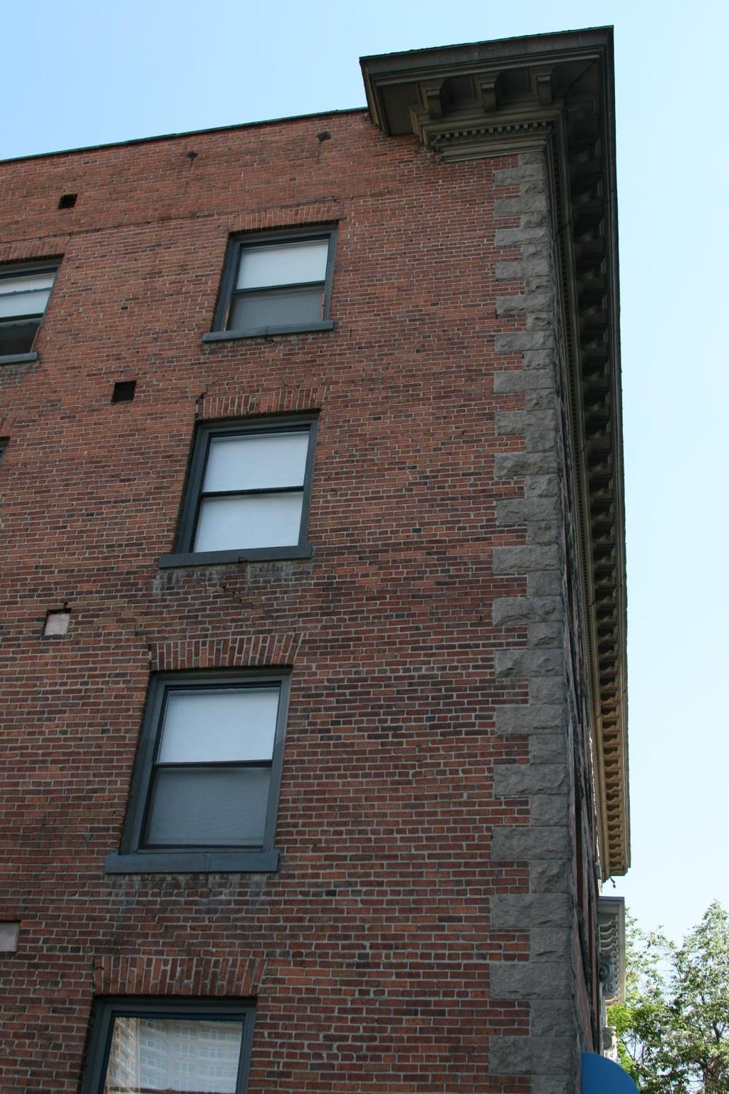
38 Unreinforced Masonry Buildings


39 Unreinforced masonry building (URM) that collapsed during the Wells earthquake on 21 February 2008 View from back, 20 May 2009 View from front, 20 May 2009
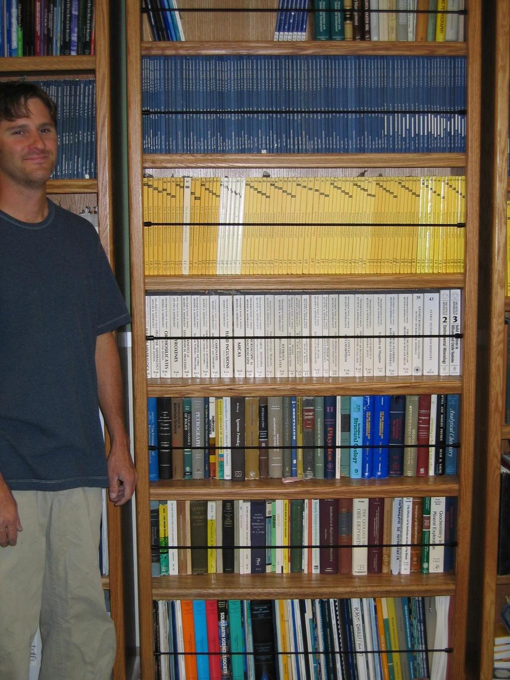
40

41

42
43

44
45
46 Definition of potential unreinforced masonry (URM) buildings in Nevada: buildings listed by County Assessors or State Public Works as built before 1974 with brick, stone, or block masonry structure. Caution: This is a preliminary study based on data provided by the County Assessors and the State of Nevada. We know there are errors in the database: URMs missed - not recorded as masonry structures URMs missed ones on federal or Indian lands URMs counted due to wrong building type in the database Wrong locations due to poor address coding Misidentifications due to lack of construction date Buildings that may have been seismically retrofitted Buildings that have been removed. Recommendation 1 (draft): Jurisdictions (cities, counties, state) should use this County Assessors data to follow up with on-theground inspections and checks of building plans. Individuals should determine if their buildings are URMs.
47 Potential URMs in Nevada totals* 7,354 Residential 16,145 Commercial & Public (city and county) 98 State-owned 23,597 TOTAL* * The total does not include buildings owned by the federal government.

48 Potential URMs Residential Commercial & Public State-owned

49 Carson City potential URMs 175 Residential 487 Commercial & Public 72 State-owned 734 TOTAL Carson City

50 Potential URMs Residential Commercial & Public State-owned Carson City
")
51 Douglas County Potential URM Buildings 114 Commercial & Public (yel 294 Residential (green) 408 total

52 Nonstructural damage often can be easily prevented.


53 Earthquake-secure bookshelves in the office of the State Geologist


54 Secured computers at the Clark County Building Department
55

56
57 Thank you! And thanks to Jon Price, Gary Johnson, Christine Ballard, Heather Armeno, Irene Seeley, Linda D. Goar, and Jordan T. Hastings for their work on the open-file reports (OF 09-8 and 09-9), which are available as online documents at From there, go to online documents at then scroll down to OF 09-8 or Link to the fault map from OF 09-9.
58 Web Addresses Earthquake Fault Map
Earthquake Hazards in Henderson
 Earthquake Hazards in Henderson Craig M. depolo Nevada Bureau of Mines and Geology Nevada Hazard Mitigation Planning Committee November 15, 2012 Earthquake Truths The consequences of bad earthquakes to
Earthquake Hazards in Washoe County
 Earthquake Hazards in Washoe County Craig M. depolo Nevada Bureau of Mines and Geology Nevada Hazard Mitigation Planning Committee August 13, 2013 Earthquake Truths The consequences of damaging earthquakes
Earthquake Faults, Historical Earthquakes, and Earthquake Preparedness. Craig depolo Nevada Bureau of Mines and Geology
 Earthquake Faults, Historical Earthquakes, and Earthquake Preparedness Craig depolo Nevada Bureau of Mines and Geology Earthquake Jack in the Box Analog Earthquake Faults = box and spring (bigger the
WESTERN STATES SEISMIC POLICY COUNCIL POLICY RECOMMENDATION Earthquake and Tsunami Planning Scenarios
 WESTERN STATES SEISMIC POLICY COUNCIL POLICY RECOMMENDATION 18-1 Earthquake and Tsunami Planning Scenarios Policy Recommendation 18-1 WSSPC strongly encourages states, provinces, territories, First Nations,
Layers (Layers in italics indicate group layers.) MyHazards MyPlan* Floods and Drought Landslides - USGS
 MyHazards MyPlan* Floods and Drought Landslides - USGS") MyHazards and MyPlan WebApps for Nevada Geohazards Over 100 hazard layers related to floods, fires, earthquakes, radon, and other supporting reference layers. Powerful educational and decision-making tools
MyHazards and MyPlan WebApps for Nevada Geohazards Over 100 hazard layers related to floods, fires, earthquakes, radon, and other supporting reference layers. Powerful educational and decision-making tools
Borah Peak Earthquake HAZUS Scenario Project Executive Summary Idaho Bureau of Homeland Security Idaho Geological Survey Western States Seismic
 Borah Peak Earthquake HAZUS Scenario Project Executive Summary Idaho Bureau of Homeland Security Idaho Geological Survey Western States Seismic Policy Council 12/30/2008 The HAZUS-MH analysis of the Borah
In the early morning hours of
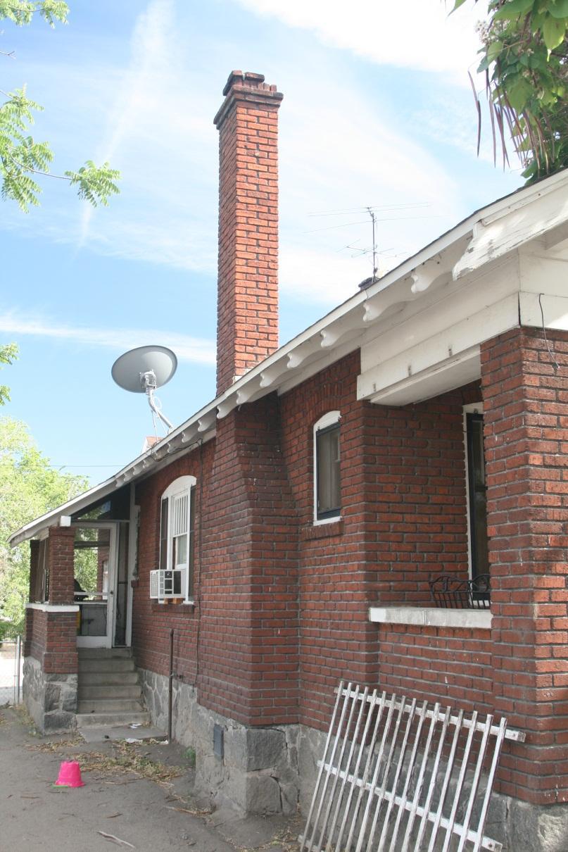
 Figure 1. Brace that Chimney! Bracing of masonry chimneys is very difficult to do properly and has generally been ineffective in preventing their failure during earthquakes. While replacement of the chimney
Finding Fault Geologic History from a Road Cut
 Finding Fault Geologic History from a Road Cut Elisabeth M. Price, DD LaPointe, and Jonathan G. Price 4 July 2005 Introduction Earth science is an important science to present to students because it directly
Interpretive Map Series 24
 Oregon Department of Geology and Mineral Industries Interpretive Map Series 24 Geologic Hazards, Earthquake and Landslide Hazard Maps, and Future Earthquake Damage Estimates for Six Counties in the Mid/Southern
Guidelines for Site-Specific Seismic Hazard Reports for Essential and Hazardous Facilities and Major and Special-Occupancy Structures in Oregon
 Guidelines for Site-Specific Seismic Hazard Reports for Essential and Hazardous Facilities and Major and Special-Occupancy Structures in Oregon By the Oregon Board of Geologist Examiners and the Oregon
Foreshocks to Major Earthquakes In Nevada. Craig M. depolo Nevada Bureau of Mines and Geology
 Foreshocks to Major Earthquakes In Nevada Craig M. depolo Nevada Bureau of Mines and Geology Review foreshocks, particularly the 2008 Mogul earthquake, foreshock statistics and implications, multiple earthquakes
Mitigation Strategies for Earthquake Surface Rupture Hazard in the Basin and Range Province
 Mitigation Strategies for Earthquake Surface Rupture Hazard in the Basin and Range Province 1992 Landers, California Earthquake The Mitigation of Earthquake Surface Faulting in the Basin and Range Province:
HAZUS-MH: Earthquake Event Report
 HAZUS-MH: Earthquake Event Report Region Name: El Paso County Earthquake Scenario: El Paso County Random EQ Print Date: February 08, 2006 Disclaimer: The estimates of social and economic impacts contained
GPS Strain & Earthquakes Unit 4: GPS strain analysis examples Student exercise
 GPS Strain & Earthquakes Unit 4: GPS strain analysis examples Student exercise Example 1: Olympic Peninsula Name: Please complete the following worksheet to estimate, calculate, and interpret the strain
9. GEOLOGY, SOILS, AND MINERALS
 June 28, 2018 Page 9-1 9. GEOLOGY, SOILS, AND MINERALS This EIR chapter describes the existing geological, soil, and mineral conditions in the planning area. The chapter includes the regulatory framework
NEVADA EARTHQUAKE SAFETY COUNCIL c/o Nevada Bureau of Mines and Geology (775) Ext 126. February 17, 2009
 Ext 126. February 17, 2009") NEVADA EARTHQUAKE SAFETY COUNCIL c/o Nevada Bureau of Mines and Geology (775) 784-6691 Ext 126 University on Nevada, Reno (775) 784-1709 Fax Mail Stop 178 e-mail: jprice@unr.edu Reno, Nevada 89557-0088
NEVADA EARTHQUAKE SAFETY COUNCIL c/o Nevada Bureau of Mines and Geology (775) 784-6691 Ext 126 University on Nevada, Reno (775) 784-1709 Fax Mail Stop 178 e-mail: jprice@unr.edu Reno, Nevada 89557-0088
Risk Identification using Hazus
 Risk Identification using Hazus City of Boston, Suffolk County, MA Dave Shortman, GISP, CFM 6/21/2016 Agenda Objective Project Location Hazus Overview Hazus Level 2 Risk Assessment Comparison and Reporting
M-8.1 EARTHQUAKE 87KM SW OF PIJIJIAPAN, MEXICO EXACT LOCATION: N W DEPTH: 69.7KM SEPTEMBER 7, 11:49 PST
 M-8.1 EARTHQUAKE 87KM SW OF PIJIJIAPAN, MEXICO EXACT LOCATION: 15.068 N 93.715 W DEPTH: 69.7KM SEPTEMBER 7, 2017 @ 11:49 PST Photo: Luis Alberto Cruz / AP Photo: Carlos Jasso 1 THE 2017 CHIAPAS MEXICO
Interpretive Map Series 24
 Oregon Department of Geology and Mineral Industries Interpretive Map Series 24 Geologic Hazards, and Hazard Maps, and Future Damage Estimates for Six Counties in the Mid/Southern Willamette Valley Including
Downtown Anchorage Seismic Risk Assessment & Land Use Regulations to Mitigate Seismic Risk
 Prepared for: The Municipality of Anchorage Planning Department and the Geotechnical Advisory Commission Downtown Anchorage Seismic Risk Assessment & Land Use Regulations to Mitigate Seismic Risk Prepared
Cascadia megathrust earthquakes: reducing risk through science, engineering, and planning
 Cascadia megathrust earthquakes: reducing risk through science, engineering, and planning NSF Hazards SEES EAR-1331412 Urban Science and Engineering Workshop 21 July 2014 Everything to do with M9 Cascadia
Preview Mode: ON Earthquake Risk in Stable, Intraplate Regions: the Case. of Perth, Australia. Historical Seismicity in the Perth Region
 Preview Mode: ON Earthquake Risk in Stable, Intraplate Regions: the Case Editor s note: There is often a tendency to discount earthquake risk in of Perth, Australia 02.2010 AIRCurrents regions where earthquakes
Seismic Hazard Abatement Program
 Seismic Hazard Abatement Program Recommendations To take the first steps toward a seismic mitigation program for older existing buildings To improve our current regulatory system for implementation of
PAHRUMP REGIONAL PLANNING DISTRICT MASTER PLAN 2010
 CHAPTER TWENTY SEISMIC SAFETY PLAN (This Plan is from the 1999 Pahrump Regional Planning District Master Plan) Pursuant to NRS 278.160, this topic consists of an identification and appraisal of seismic
Usually, only a couple of centuries of earthquake data is available, much shorter than the complete seismic cycle for most plate motions.
 Earthquake Hazard Analysis estimate the hazard presented by earthquakes in a given region Hazard analysis is related to long term prediction and provides a basis to expressed hazard in probabilistic terms.
Geothermal Systems: Geologic Origins of a Vast Energy Resource
 Geothermal Systems: Geologic Origins of a Vast Energy Resource Energy From the Earth Energy-Land-Water Connections Speaker Series James E. Faulds, PhD Nevada State Geologist and Professor Nevada Bureau
Basic Seismological Characterization for Platte County, Wyoming. James C. Case Wyoming State Geological Survey July, 2002 BACKGROUND
 Basic Seismological Characterization for Platte County, Wyoming by James C. Case Wyoming State Geological Survey July, 2002 BACKGROUND Seismological characterizations of an area can range from an analysis
LANDUSE APPLICATIONS OF EARTHQUAKE HAZARD MAPS CALIFORNIA EXPERIENCE
 LANDUSE APPLICATIONS OF EARTHQUAKE HAZARD MAPS CALIFORNIA EXPERIENCE Thomas C. Vlasic Vice President Spangle Associates Portola Valley, California INTRODUCTION The focus of this report is primarily on
M 7.1 EARTHQUAKE 5KM ENE OF RABOSO, MEXICO EXACT LOCATION: N W DEPTH: 51.0KM SEPTEMBER 19, 1:14 LOCAL TIME
 M 7.1 EARTHQUAKE 5KM ENE OF RABOSO, MEXICO EXACT LOCATION: 18.584 N 98.399 W DEPTH: 51.0KM SEPTEMBER 19, 2017 @ 1:14 LOCAL TIME Photo: Eduardo Verdugo / AP Photo: Alfredo Estrella/ Agence France-Presse/
Estimation of Short Term Shelter Needs FEMA Earthquake HAZUS Model
 July 2017 ESRI International Users Conference Estimation of Short Term Shelter Needs FEMA Earthquake HAZUS Model Techniques & Results Douglas Schenk / Sampa Patra GIS Group / Information Services Division
Three Fs of earthquakes: forces, faults, and friction. Slow accumulation and rapid release of elastic energy.
 Earthquake Machine Stick-slip: Elastic Rebound Theory Jerky motions on faults produce EQs Three Fs of earthquakes: forces, faults, and friction. Slow accumulation and rapid release of elastic energy. Three
IV. ENVIRONMENTAL IMPACT ANALYSIS E. GEOLOGY AND SOILS
 IV. ENVIRONMENTAL IMPACT ANALYSIS E. GEOLOGY AND SOILS The following section is a summary of the geotechnical report conducted for the Proposed Project. The Geotechnical Engineering Investigation (the
NPTEL Online - IIT Kanpur. Course Name Geotechnical Earthquake Engineering. Department IIT Kanpur
 NPTEL Online - IIT Kanpur Course Name Geotechnical Earthquake Engineering Department Instructor Civil Engineering Department IIT Kanpur Prof. N.R. Patra Module 1 INTRODUCTION TO GEOTECHNICAL ENGINEERING
Preliminary Earthquake Risk Management Strategy Plan of Eskisehir, Turkey by using GIS
 Preliminary Earthquake Risk Management Strategy Plan of Eskisehir, Turkey by using GIS Metin Altan, Ferah Özturk and Can Ayday Space and Satellite Sciences Research Institute Anadolu University, TURKEY
GPS Strain & Earthquakes Unit 5: 2014 South Napa earthquake GPS strain analysis student exercise
 GPS Strain & Earthquakes Unit 5: 2014 South Napa earthquake GPS strain analysis student exercise Strain Analysis Introduction Name: The earthquake cycle can be viewed as a process of slow strain accumulation
Name Date Class. radiate in all directions, carrying some of the. of plate boundaries have different usual patterns of.
 Chapter Outline Earthquakes CHAPTER 6 Lesson 1: Earthquakes and Plate Boundaries A. What is an earthquake? 1. A(n) is the rupture and sudden movement of rocks along a fault. A fault is a fracture surface
Seth J. Wittke Wyoming State Geological Survey
 Seth J. Wittke Wyoming State Geological Survey Project initiation Data manipulation Scenarios Creating the IMS Lessons learned County-wide block level probabilistic models created in 2004 for state mitigation
Magnitude 6.3 SOUTH ISLAND OF NEW ZEALAND
 A magnitude 6.3 earthquake shook the southern New Zealand city of Christchurch. At least 100 people are reported dead, and there are reports of collapsed buildings, cracked streets and flooding due to
The Impact of the 2010 Darfield (Canterbury) Earthquake on the Geodetic Infrastructure in New Zealand 1
 Earthquake on the Geodetic Infrastructure in New Zealand 1") The Impact of the 2010 Darfield (Canterbury) Earthquake on the Geodetic Infrastructure in New Zealand 1 Graeme BLICK, John BEAVAN, Chris CROOK, Nic DONNELLY Keywords: Darfield Earthquake, control, survey,
The Impact of the 2010 Darfield (Canterbury) Earthquake on the Geodetic Infrastructure in New Zealand 1 Graeme BLICK, John BEAVAN, Chris CROOK, Nic DONNELLY Keywords: Darfield Earthquake, control, survey,
Performing seismic scenarios in the Luchon-Val d Aran area, Central Pyrenees
 Performing seismic scenarios in the Luchon-Val d Aran area, Central Pyrenees 7th EUROGEO, Bologna, Italy, 12th-15th june 2012 Authors: A. Roullé (BRGM), A. Macau (IGC), S. Figueras (IGC), D. Monfort- Climent
Development of U. S. National Seismic Hazard Maps and Implementation in the International Building Code
 Development of U. S. National Seismic Hazard Maps and Implementation in the International Building Code Mark D. Petersen (U.S. Geological Survey) http://earthquake.usgs.gov/hazmaps/ Seismic hazard analysis
Geotechnical Extreme Events Reconnaissance Report:
 Geotechnical Extreme Events Reconnaissance Report: The Performance of Structures in Densely Urbanized Areas Affected by Surface Fault Rupture During the August 24, 2014 M6 South Napa Earthquake, California,
158 Reducing Earthquake Losses
 ndex A Accelerographs, 64 Active control systems, 83-84 Active mass damping, 83 Active tendons, 83 Advocates, role of, 116 Air Force Office of Scientific Research, 133 Alaska, 42-43 Alquist-Priolo Act,
(First Edition: prepared on 29/12/2003)
") (First Edition: prepared on 29/12/2003) Dr Sassan Eshghi 1 and Dr Mehdi Zaré 2 International Institute of Earthquake Engineering and Seismology, Tehran, P.O.Box: 19395/3913, IRAN e-mails: 1)s.eshghi@iiees.ac.ir,
(First Edition: prepared on 29/12/2003) Dr Sassan Eshghi 1 and Dr Mehdi Zaré 2 International Institute of Earthquake Engineering and Seismology, Tehran, P.O.Box: 19395/3913, IRAN e-mails: 1)s.eshghi@iiees.ac.ir,
Investigation 5: What happens when plates move sideways past each other?
 Tectonics Investigation 5: Teacher Guide Investigation 5: What happens when plates move sideways past each other? Plates move sideways past each other at transform boundaries. At these boundaries, the
4.5 GEOLOGY, SOILS AND SEISMICITY
 4.5 This section summarizes information on geology, soils and seismic hazards, and mineral resources in the Truckee area, as well as potential area-wide geologic hazards and regional seismic characteristics
ENGINEER S CERTIFICATION OF FAULT AREA DEMONSTRATION (40 CFR )
") PLATTE RIVER POWER AUTHORITY RAWHIDE ENERGY STATION BOTTOM ASH TRANSFER (BAT) IMPOUNDMENTS LARIMER COUNTY, CO ENGINEER S CERTIFICATION OF FAULT AREA DEMONSTRATION (40 CFR 257.62) FOR COAL COMBUSTION RESIDUALS
PLATTE RIVER POWER AUTHORITY RAWHIDE ENERGY STATION BOTTOM ASH TRANSFER (BAT) IMPOUNDMENTS LARIMER COUNTY, CO ENGINEER S CERTIFICATION OF FAULT AREA DEMONSTRATION (40 CFR 257.62) FOR COAL COMBUSTION RESIDUALS
Homework Assignment II. Seismological Exercises Fall 2014
 Page 1 of 8 EENS 3050 Tulane University Natural Disasters Prof. Stephen A. Nelson Homework Assignment II. Seismological Exercises Fall 2014 This page last updated on 03-Sep-2014 Answer the following questions.
Lab 9: Satellite Geodesy (35 points)
") Lab 9: Satellite Geodesy (35 points) Here you will work with GPS Time Series data to explore plate motion and deformation in California. This lab modifies an exercise found here: http://www.unavco.org:8080/cws/pbonucleus/draftresources/sanandreas/
Lab 9: Satellite Geodesy (35 points) Here you will work with GPS Time Series data to explore plate motion and deformation in California. This lab modifies an exercise found here: http://www.unavco.org:8080/cws/pbonucleus/draftresources/sanandreas/
NEVADA EARTHQUAKE SAFETY COUNCIL c/o Nevada Bureau of Mines and Geology (775) Ext 126
 Ext 126") TO: FROM: NEVADA EARTHQUAKE SAFETY COUNCIL c/o Nevada Bureau of Mines and Geology (775) 784-6691 Ext 126 University on Nevada, Reno (775) 784-1709 Fax Mail Stop 178 e-mail: jprice@unr.edu Reno, Nevada
TO: FROM: NEVADA EARTHQUAKE SAFETY COUNCIL c/o Nevada Bureau of Mines and Geology (775) 784-6691 Ext 126 University on Nevada, Reno (775) 784-1709 Fax Mail Stop 178 e-mail: jprice@unr.edu Reno, Nevada
CITY OF RIVERSIDE USING HAZUS TO CREATE A EARTHQUAKE PLANNING GUIDE FOR A UNIFIED FIELD RESPONSE
 CITY OF RIVERSIDE USING HAZUS TO CREATE A EARTHQUAKE PLANNING GUIDE FOR A UNIFIED FIELD RESPONSE Presented by the Phil McCormick City of Riverside Office of Emergency Management HISTORY The City had several
Part 2 - Engineering Characterization of Earthquakes and Seismic Hazard. Earthquake Environment
 Part 2 - Engineering Characterization of Earthquakes and Seismic Hazard Ultimately what we want is a seismic intensity measure that will allow us to quantify effect of an earthquake on a structure. S a
Low-Latency Earthquake Displacement Fields for Tsunami Early Warning and Rapid Response Support
 Low-Latency Earthquake Displacement Fields for Tsunami Early Warning and Rapid Response Support Hans-Peter Plag, Geoffrey Blewitt Nevada Bureau of Mines and Geology and Seismological Laboratory University
Earthquake Source. Kazuki Koketsu. Special Session: Great East Japan (Tohoku) Earthquake. Earthquake Research Institute, University of Tokyo
 Earthquake. Earthquake Research Institute, University of Tokyo") 2012/9/24 17:20-17:35 WCEE SS24.4 Special Session: Great East Japan (Tohoku) Earthquake Earthquake Source Kazuki Koketsu Earthquake Research Institute, University of Tokyo 1 Names and features of the earthquake
2012/9/24 17:20-17:35 WCEE SS24.4 Special Session: Great East Japan (Tohoku) Earthquake Earthquake Source Kazuki Koketsu Earthquake Research Institute, University of Tokyo 1 Names and features of the earthquake
RISK ASSESSMENT COMMUNITY PROFILE NATURAL HAZARDS COMMUNITY RISK PROFILES. Page 13 of 524
 RISK ASSESSMENT COMMUNITY PROFILE NATURAL HAZARDS COMMUNITY RISK PROFILES Page 13 of 524 Introduction The Risk Assessment identifies and characterizes Tillamook County s natural hazards and describes how
Separating Tectonic, Magmatic, Hydrological, and Landslide Signals in GPS Measurements near Lake Tahoe, Nevada-California
 Separating Tectonic, Magmatic, Hydrological, and Landslide Signals in GPS Measurements near Lake Tahoe, Nevada-California Geoffrey Blewitt, Corné Kreemer, William C. Hammond, & Hans-Peter Plag NV Geodetic
Overview. Tools of the Trade. USGS Decision-Making Tools for Pre-Earthquake Mitigation and Post-Earthquake Response
 USGS Decision-Making Tools for Pre-Earthquake Mitigation and Post-Earthquake Response Tools of the Trade DAVID WALD United States Geological Survey NEHRP Workshop: Developing Earthquake Scenarios Sept
B.2 Sources for Hazard Identification, Profiling, and Ranking (Section 3) Overview of Sussex County s History of Hazards
 Overview of Sussex County s History of Hazards") Appendix B Sources B.1 Sources for Planning Process (Section 2) FEMA. Mitigation Planning Guidance (386 Series). Available on the web at: http://www.fema.gov/plan/mitplanning/planning_resources.shtm FEMA
Appendix B Sources B.1 Sources for Planning Process (Section 2) FEMA. Mitigation Planning Guidance (386 Series). Available on the web at: http://www.fema.gov/plan/mitplanning/planning_resources.shtm FEMA
SEISMIC HAZARD ANALYSIS. Instructional Material Complementing FEMA 451, Design Examples Seismic Hazard Analysis 5a - 1
 SEISMIC HAZARD ANALYSIS Instructional Material Complementing FEMA 451, Design Examples Seismic Hazard Analysis 5a - 1 Seismic Hazard Analysis Deterministic procedures Probabilistic procedures USGS hazard
Earthquakes. Earthquake Magnitudes 10/1/2013. Environmental Geology Chapter 8 Earthquakes and Related Phenomena
 Environmental Geology Chapter 8 Earthquakes and Related Phenomena Fall 2013 Northridge 1994 Kobe 1995 Mexico City 1985 China 2008 Earthquakes Earthquake Magnitudes Earthquake Magnitudes Richter Magnitude
4.1 Hazard Identification: Natural Hazards
 data is provided in an annex, it should be assumed that the risk and potential impacts to the affected jurisdiction are similar to those described here for the entire Sacramento County Planning Area. This
Application of a GIS for Earthquake Hazard Assessment and Risk Mitigation in Vietnam
 Application of a GIS for Earthquake Hazard Assessment and Risk Mitigation in Vietnam Nguyen Hong Phuong Earthquake Information and Tsunami Warning Centre, VAST OUTLINE Introduction Fault Source Model and
The Earthquake Cycle Chapter :: n/a
 The Earthquake Cycle Chapter :: n/a A German seismogram of the 1906 SF EQ Image courtesy of San Francisco Public Library Stages of the Earthquake Cycle The Earthquake cycle is split into several distinct
Impact : Changes to Existing Topography (Less than Significant)
") 4.2 Land Resources 4.2.1 Alternative A Proposed Action Impact 4.2.1-1: Changes to Existing Topography (Less than Significant) Development of the project site would involve grading and other earthwork as
4.2 Land Resources 4.2.1 Alternative A Proposed Action Impact 4.2.1-1: Changes to Existing Topography (Less than Significant) Development of the project site would involve grading and other earthwork as
Ground Motions from the 2008 Wells, Nevada Earthquake Sequence and Implications for Seismic Hazard
 Nevada Bureau of Mines and Geology Special Publication 36 Ground Motions from the 2008 Wells, Nevada Earthquake Sequence and Implications for Seismic Hazard by Mark Petersen 1, Kris Pankow 2, Glenn Biasi
GPS strain analysis examples Instructor notes
 GPS strain analysis examples Instructor notes Compiled by Phil Resor (Wesleyan University) This document presents several examples of GPS station triplets for different tectonic environments. These examples
Seismic Source Characterization in Siting New Nuclear Power Plants in the Central and Eastern United States
 Seismic Source Characterization in Siting New Nuclear Power Plants in the Central and Eastern United States ABSTRACT : Yong Li 1 and Nilesh Chokshi 2 1 Senior Geophysicist, 2 Deputy Director of DSER Nuclear
DEPARTMENT OF GEOLOGY AND MINERAL INDUSTRIES WAYS & MEANS SUBCOMMITTEE ON NATURAL RESOURCES MARCH 2, 2017
 DEPARTMENT OF GEOLOGY AND MINERAL INDUSTRIES WAYS & MEANS SUBCOMMITTEE ON NATURAL RESOURCES MARCH 2, 2017 1 ABOUT DOGAMI AGENCY MISSION, VISION & GOALS 2 Lidar image of a stream network along the Umpqua
Homework Assignment II. Seismological Exercises Spring 2018
 Page 1 of 8 EENS 3050 Tulane University Natural Disasters Prof. Stephen A. Nelson Homework Assignment II. Seismological Exercises Spring 2018 This page last updated on 30-Jan-2018 Answer the following
September 28, 2004 Parkfield Earthquake
 PRELIMINARY REPORT ON SEPTEMBER 28, 2004 PARKFIELD EARTHQUAKE By Rakesh K. Goel, M.EERI and Charles B. Chadwell, M. EERI Department of Civil & Environmental Engineering, California Polytechnic State University,
IV. ENVIRONMENTAL IMPACT ANALYSIS G. GEOLOGY AND SOILS
 IV. ENVIRONMENTAL IMPACT ANALYSIS G. GEOLOGY AND SOILS The following section is a summary of the geotechnical report conducted for the proposed project. The Report of Geotechnical Investigation Proposed
3D Seismic Hazard and Risk Maps for Earthquake Awareness of Citizens with Aids of GIS and Remote Sensing Technologies
 3D Seismic Hazard and Risk Maps for Earthquake Awareness of Citizens with Aids of GIS and Remote Sensing Technologies Saburoh Midorikawa Tokyo Institute of Technology In Japan, seismic hazard and risk
Applications on Slope Land Management through GIS Technology
 Applications on Slope Land Management through GIS Technology Hsiu-Yi Ko, Jo-Yu Liu,Tai-Chung Hsiao, Tian-Ying Chou, Ying-Hui Chang Geographic Information Systems Research Center of Feng Chia University
By Chris Mikes and David Fleck Digital Terrain Analysis GEOG 593. Overview
 Earthquake and Infrastructure Damage Analysis in Multnomah and Clackamas Counties: The Application of LiDAR In The Development of an Emergency Response Plan By Chris Mikes and David Fleck Digital Terrain
Updated MCE R & MCE G Ground Motions in 2015 NEHRP Provisions (& ASCE/SEI 7-16)
") Updated MCE R & MCE G Ground Motions in 2015 NEHRP Provisions (& ASCE/SEI 7-16) EERI 2016 Seminar ASCE Geotechnical on Next Generation & Structural Engineering Attenuation Congress Models Nicolas Luco
Updated MCE R & MCE G Ground Motions in 2015 NEHRP Provisions (& ASCE/SEI 7-16) EERI 2016 Seminar ASCE Geotechnical on Next Generation & Structural Engineering Attenuation Congress Models Nicolas Luco
Life after Cal: Adapting to Change and Enjoying your Time in Graduate School
 Life after Cal: Adapting to Change and Enjoying your Time in Graduate School Tyler Seaman Fall 2013 http://eps.berkeley.edu/~brimhall/alumni_student_forum/website_alumni_student_forum.htm Outline! Background!
Targeting of Potential Geothermal Resources in the Great Basin from Regional Relationships between Geodetic Strain and Geological Structures
 Targeting of Potential Geothermal Resources in the Great Basin from Regional Relationships between Geodetic Strain and Geological Structures Geoffrey Blewitt and Mark Coolbaugh Great Basin Center for Geothermal
Baldwin County, Alabama
 2015 Baldwin County, Alabama Multi-Hazard Mitigation Plan I. Comprehensive Plan A multi-jurisdiction plan City of Bay Minette City of Daphne Town of Elberta City of Fairhope City of Foley City of Gulf
Earthquakes. Chapter Test A. Multiple Choice. Write the letter of the correct answer on the line at the left.
 Earthquakes Chapter Test A Multiple Choice Write the letter of the correct answer on the line at the left. 1. Stress that pushes a mass of rock in two opposite directions is called a. shearing. b. tension.
Magnitude 6.9 GULF OF CALIFORNIA
 A pair of strong earthquakes struck off the coast of Mexico early Thursday only minutes apart. The magnitude 6.9 and 6.2 were centered about 85 miles northeast of Guerrero Negro in the Mexican state of
Forces in Earth s Crust
 Name Date Class Earthquakes Section Summary Forces in Earth s Crust Guide for Reading How does stress in the crust change Earth s surface? Where are faults usually found, and why do they form? What land
Crustal Deformation Earth - Chapter Pearson Education, Inc.
 Crustal Deformation Earth - Chapter 10 Structural Geology Structural geologists study the architecture and processes responsible for deformation of Earth s crust. A working knowledge of rock structures
Earthquakes.
 Earthquakes http://thismodernworld.com/comic-archive Elastic rebound http://projects.crustal.ucsb.edu/understanding/elastic/rebound.html Elastic rebound Rocks store energy elastically When stored stress
Resiliency Assessed by Comparing Scenarios
 Resiliency Assessed by Comparing Scenarios Robert A. Bauer Illinois State Geological Survey Use HAZUS to estimate losses from nearby strong events vs. NLE-11 New Madrid Catastrophic M7.7 and NLE-11 Mt.
Earthquakes and Faulting
 Earthquakes and Faulting Crustal Strength Profile Quakes happen in the strong, brittle layers Great San Francisco Earthquake April 18, 1906, 5:12 AM Quake lasted about 60 seconds San Francisco was devastated
5.2. IDENTIFICATION OF NATURAL HAZARDS OF CONCERN
 5.2. IDENTIFICATION OF NATURAL HAZARDS OF CONCERN To provide a strong foundation for mitigation strategies considered in Sections 6 and 9, County considered a full range of natural hazards that could impact
RESEARCH ASSIGNMENT SAN ANDREAS FAULT SYSTEM: - TECTONICS, GEOLOGY, FAULT DYNAMICS, AND HAZARDS -
 RESEARCH ASSIGNMENT SAN ANDREAS FAULT SYSTEM: - TECTONICS, GEOLOGY, FAULT DYNAMICS, AND HAZARDS - Due Date: TUESDAY JULY 25, 2017 by 11:59 pm A. Introduction: This writing assignment involves the research,
What is an earthquake?
 What is an earthquake? Shaking or vibration of the ground rocks undergoing deformation break suddenly along a fault 1906 San Francisco earthquake Oblique view of the San Andreas fault and San Francisco
Important Concepts. Earthquake hazards can be categorized as:
 Lecture 1 Page 1 Important Concepts Monday, August 17, 2009 1:05 PM Earthquake Engineering is a branch of Civil Engineering that requires expertise in geology, seismology, civil engineering and risk assessment.
The Magnitude 7.2 Earthquake from the West Valley Fault: Implications for Metro Manila and Nearby Provinces
 The Magnitude 7.2 Earthquake from the West Valley Fault: Implications for Metro Manila and Nearby Provinces First DRI Collegiate Conference in the Philippines 16 March 2017 Renato U. Solidum, Jr. Department
GEOLOGY, SOILS, AND SEISMICITY
 4.9 GEOLOGY, SOILS, AND SEISMICITY 4.9.1 Introduction Information about the geological conditions and seismic hazards in the study area was summarized in the FEIR, and was based on the Geotechnical Exploration
4.5 GEOLOGY AND SEISMICITY
 4.5 GEOLOGY AND SEISMICITY INTRODUCTION This section identifies the potential for geologic and seismic hazards to occur on or near the proposed project site. Issues of concern include suitability of soil
HAZUS-MH: A Predictable Hurricane Risk Assessment Tool for the City of Houston and Harris County
 HAZUS-MH: A Predictable Hurricane Risk Assessment Tool for the City of Houston and Harris County Presented by Melvin G. Spinks, P.E., President Annie Ding, PhD, GISP October 29, 2008 Rice University Contents
Chapt pt 15 er EARTHQUAKES! BFRB P 215 ages -226
 Chapter 15 EARTHQUAKES! BFRB Pages 215-226226 Earthquake causes An earthquake is the shaking of the Earth s crust caused by a release of energy The movement of the Earth s plates causes most earthquakes
Activity Pacific Northwest Tectonic Block Model
 Activity Pacific Northwest Tectonic Block Model The Cascadia tectonic margin is caught between several tectonic forces, during the relentless motions of the giant Pacific Plate, the smaller subducting
Minutes of the Nevada Hazard Mitigation Planning Committee Tuesday, May 7, 2013, at 12:30 pm
 Minutes of the Nevada Hazard Mitigation Planning Committee Tuesday, May 7, 2013, at 12:30 pm Tonopah Convention Center, 301 W. Brougher St. Tonopah, Nevada 89049, county seat of Nye County Before the meeting
HAZARD IDENTIFICATION AND VULNERABILITY ANALYSIS (HIVA) Walla Walla County, Washington EARTHQUAKE
 Walla Walla County, Washington EARTHQUAKE") HAZARD IDENTIFICATION AND VULNERABILITY ANALYSIS (HIVA) Walla Walla County, Washington Hazard Overview EARTHQUAKE An earthquake is caused by a sudden slip on a fault. Stresses in the earth's outer layer
HAZARD IDENTIFICATION AND VULNERABILITY ANALYSIS (HIVA) Walla Walla County, Washington Hazard Overview EARTHQUAKE An earthquake is caused by a sudden slip on a fault. Stresses in the earth's outer layer
Preliminary Geotechnical Observations of the July 29, 2008 Southern California Earthquake
 Preliminary Geotechnical Observations of the July 29, 2008 Southern California Earthquake Provided for: Geo-Engineering Earthquake Reconnaissance (GEER) Association Prepared by: Pirooz Kashighandi, Salih
New USGS Maps Identify Potential Ground- Shaking Hazards in 2017
 New USGS Maps Identify Potential Ground- Shaking Hazards in 2017 New USGS Maps Identify Potential Ground-Shaking Hazards in 2017 The central U.S. faces continued hazards from human-induced earthquakes
San Andreas Movie Can It Happen?
 San Andreas Movie Can It Happen? Learning Objectives (LO) Lecture 14: Faults and Quakes Read: Chapter 10 and 11 Homework #12 due Thursday 12pm What we ll learn today:! 1. Compare strike-slip to dip-slip