Probabilistic eruption forecasting and the call for an evacuation
|
|
|
- Oscar Clark
- 5 years ago
- Views:
Transcription
1 1 Probabilistic eruption forecasting and the call for an evacuation Warner Marzocchi Istituto Nazionale di Geofisica e Vulcanologia, Italy. Gordon Woo Risk Management Solutions, United Kingdom. Short title: ERUPTION FORECASTING AND EVACUATION
2 2 Abstract. One of the most critical practical actions to reduce volcanic risk is the evacuation of people from threatened areas during volcanic unrest. Despite its importance, this decision is usually arrived at subjectively by a few individuals, with little quantitative decision support. Here, we propose a possible strategy to integrate a probabilistic scheme for eruption forecasting and cost-benefit analysis, with an application to the call for an evacuation of one of the highest risk volcanoes: Vesuvius. This approach has the following merits. First, it incorporates a decision-analysis framework, expressed in terms of event probability, accounting for all modes of available hazard knowledge. Secondly, it is a scientific tool, based on quantitative and transparent rules that can be tested. Finally, since the quantitative rules are defined during a period of quiescence, it allows prior scrutiny of any scientific input into the model, so minimizing the external stress on scientists during an actual emergency phase. Whilst we specifically report the case of Vesuvius during the MESIMEX exercise, the approach can be generalized to other types of natural catastrophe.
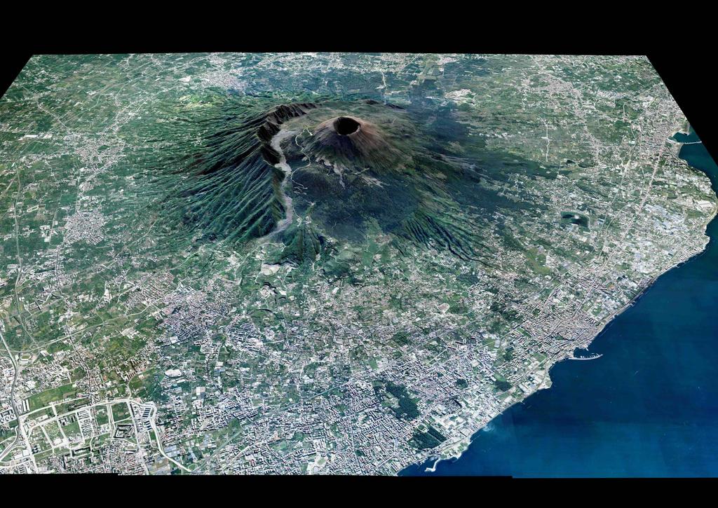
3 3 Introduction There is an exceptional class of extreme rare natural hazard events which pose a critical evacuation dilemma for civil protection officials, and the scientists who advise them. A common feature of these events is that they threaten the lives of many hundreds of thousands of people, whose evacuation from danger would be logistically complex and uncertain in its effectiveness and duration. Another feature of these events is that the complexity of the processes involved make a deterministic functional prediction (i.e., with a leading time long enough to take some practical actions) an unreliable goal [Sparks, 2003]; in general, scientists have some forecasting skill at providing timely warnings, but these are subject to a significant risk of false alarms. In a meteorological context, an example would be a Category 5 Atlantic hurricane track potentially heading towards Manhattan, but which might veer seawards. Compared with Hurricane Katrina, which claimed 1500 lives, the longer return period of this scenario creates a vastly greater challenge in evacuation decision-making. In a volcanological context, the most celebrated example of a colossal evacuation problem would be that of an eruption of Vesuvius (see pk=395&cms pk=3323&n page=4), overlooking the populous Bay of Naples (see figure 1). The fact that the size of an imminent eruption is almost indeterminate and it cannot be predicted by the precursory activity [Marzocchi et al., 2004] makes any evacuation decision in a volcanic crisis especially fraught. As part of the preparedness for an extreme natural hazard event, it
4 4 is prudent to test the evacuation decision-making process itself, along with the logistics of the evacuation process. Apart from learning what technical improvements need to be made in monitoring and communications to support an evacuation decision, the actual criteria used for decision-making can be scrutinized. As a major experiment in critical evacuation decision-making, the recent MESIMEX exercise carried out at Vesuvius ( pk=395&cms pk=3323) offers some special scientific insights. Here, we use this exercise as a tutorial example to describe a new procedure that links eruption forecasting and cost/benefit analysis to provide a quantitative and objective rule for taking the optimal decision. In the following sections we describe the methodology and the a posteriori application of the procedure to MESIMEX. The method: probability of event and cost/benefit analysis Forecasting is a fundamental goal of modern volcanology. Civil authorities and the public need to know when (and sometimes where) the eruption will occur, the size of the event, and the kind of distinctive phenomena that might occur. Forecasting is only one of many issues that authorities in charge of managing volcanic emergencies have to take into account in taking any risk-based decision or action. Emergency management involves a complex interplay between social and economic needs, and the infrastructure capability needed to sustain them. In particular, it is necessary to evaluate the vulnerability of exposed infrastructure, facilities and property, the impact of eruptions on human beings, costs vs. benefits of proposed mitigation measures, and
5 5 the level of acceptable risk for society. In addition, we need educational programs to improve the risk perception of the people living around volcanoes [Davis et al., 2005], and improved ways to communicate risk and associated uncertainties to those people, mass media, and local authorities. In this compound framework, the role of volcanology is mostly focused on providing a reliable eruption forecasting in terms of probability of some specific event of practical interest. Whilst it is natural that scientists averse to speculation should wish to be confident in an event forecast, and false alarms are detrimental both to scientific reputation and public trust, the minimization of the false alarm rate is not an optimal decision criterion where many lives are at risk, and the probability distribution for mass evacuation duration has a long tail [Woo, 2007]. A decision to evacuate in the face of an uncertain threat from a volcano falls within a common important category of economic decisions: pay a price now to avert paying a larger price later, contingent on the occurrence of an uncertain hazard event. The significant socio-economic expense of evacuation is the premium deemed worth paying so that, in the event of a volcanic eruption, the much higher cost of mass casualties is avoided. The economic character of this class of decisions is exemplified by the basic cost-loss model [Katz and Murphy, 1997]. Consider a situation where a decision-maker has to choose between two actions: (a) protect; (b) do not protect. The cost of protection is C. In the absence of protection, the decision-maker incurs a loss L, which exceeds C, if an adverse hazard state arises. Let the probability of the adverse hazard state
6 6 arising, within a specified time window, be denoted by p. If the expected expense is to be minimized, then the optimal policy is to protect, if p > C/L, but not to protect if p < C/L. The minimal expense is then min{c, pl}. In a volcanological context, protection would be evacuation, which carries a cost of C. Note that in this case, as well as in all other circumstances where the decisions are taken under uncertainty, the cost C has to properly include also the tangible (e.g., income lost) and intangible (e.g., lost of credibility) cost of false alarms. The adverse hazard state here is one of volcanic eruptivity, for which a decision not to protect carries a large loss penalty of L, measured in human fatalities. Civil protection officials would wish their scientific advisors to be sure of their forecasts, which could then be dependably followed in decision-making. However, in the real world of uncertainty, every evacuation decision involves weighing the advantages against the disadvantages. This balance of judgement is customarily assessed subjectively, if earnestly, by civil protection officials. Thus, prior to the landfall of Hurricane Katrina, New Orleans Mayor Ray Nagin worried over the city being sued if a mandatory evacuation turned out to be unwarranted [Brinkley, 2006]. Typical of urgent natural hazard crises, only hours were available to deliberate the pros and cons. Whereas it is always the prerogative of civil protection officials, who carry the burden of public responsibility, to judge the cost-benefit ratio C/L, and so establish a criterion for p, this ratio is amenable to a substantial degree of quantitative analysis, which can be conducted systematically for decision-makers well in advance of any crisis [Woo, 2007]. To do justice to the complexity of the technical issues involved may take man-years of inter-disciplinary research effort by economists,
7 7 social psychologists, transportation engineers as well as volcanologists. Such extensive analytical study by many professional experts may currently be telescoped into a few short hours of pressurized crisis deliberation by public officials. Where evacuation cost is mostly measured in terms of economic loss, and non-evacuation loss is measured in excess lives lost, then an upper bound for C/L can be obtained assuming a minimal value of a fatality, such as is used in public policy studies. Where a significant proportion of evacuees would owe their lives to an eruption, this upper bound may turn out to be quite small, equivalent to the probability p being well below evens. In such circumstances, procrastinating an evacuation decision until scientists become confident in their forecast is tantamount to under-valuing human life. For the Vesuvius case, acknowledging the stated priority of Italian Civil Protection authorities to safeguard human life, the implementation of a cost-benefit criterion for evacuation decision-making would allow this principle to be reconciled in a measured rational way with the known public intolerance of false evacuation alarms. The application to MESIMEX MESIMEX (Major Emergency Simulation Exercise) was a simulation carried out between the 17th and the 23rd of October 2006 by the Regione Campania (administrative institution of the region that includes the Neapolitan area) and the Dipartimento Nazionale della Protezione Civile (Italian Civil Protection), with the goal of testing and improving the coordination among national and European institutions, the organization of civil protection operations, and the preparedness of civil society, in
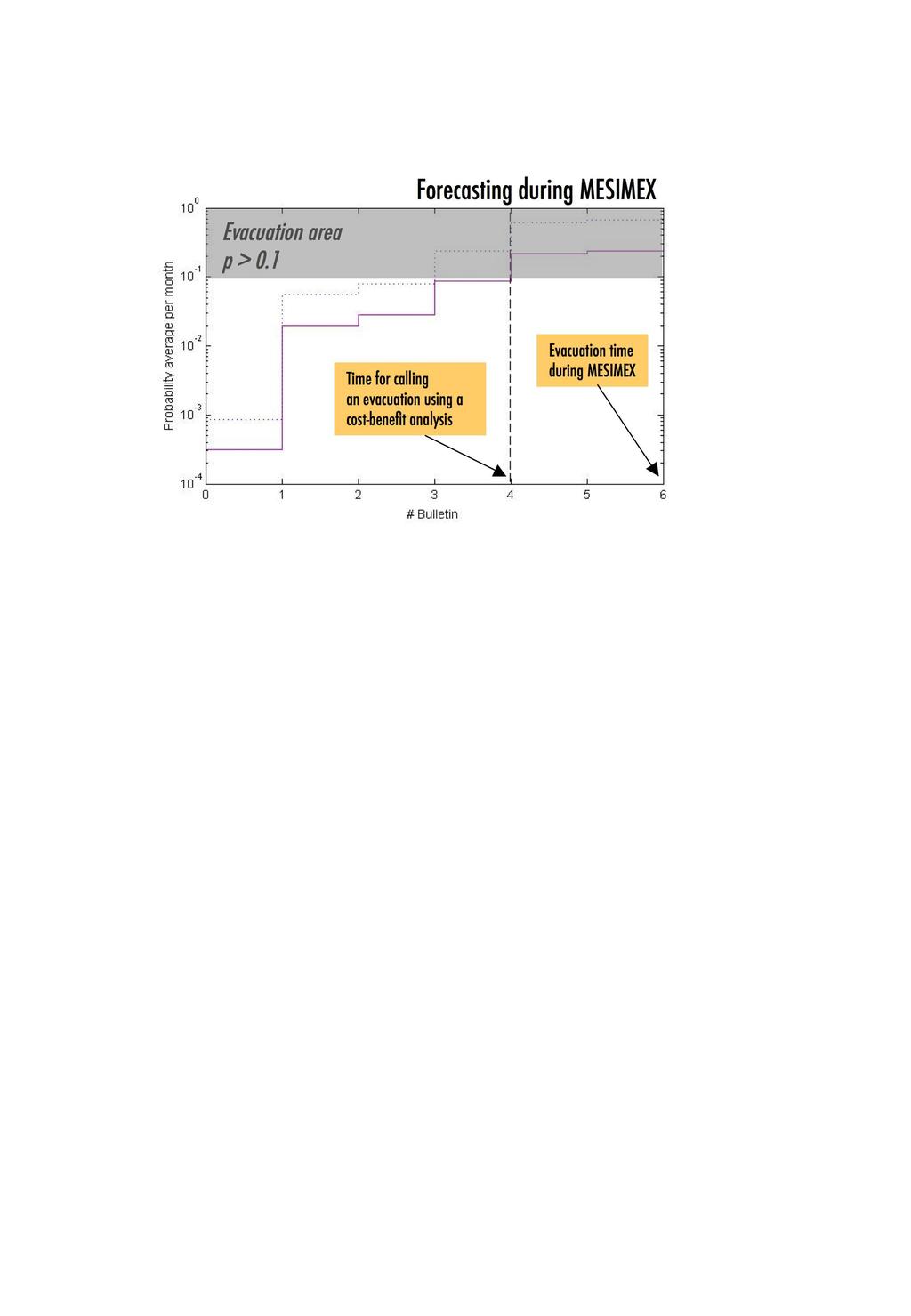
8 8 case of an eruption at Vesuvius. The core of the scientific part of the exercise was the definition of a realistic pre-eruptive scenario for Vesuvius, simulated by a pool of experts. The activity included several typical phenomena accompanying volcanic crises, such as seismic activity, deformations, gravity changes, etc. The second part of MESIMEX was devoted to an evacuation exercise as established in the Emergency Plan. In particular, a sample of two thousand people were evacuated from the Red Zone, that is the area most likely threatened by pyroclastic flows of a sub-plinian eruption, which represents the reference scenario in the Emergency Plan. As regards the pre-eruptive phase, information on the simulated activity of the volcano was dispersed within the scientific community through a series of bulletins (one or two per day) distributed through a mailing list and a dedicated internet blog. These bulletins were used as scientific input for a software code, called BET EF [Bayesian Event Tree for Eruption Forecasting; Marzocchi et al., 2004; 2007], designed to track the time evolution of the probability of eruption. The code, based on a Bayesian procedure, accounts for all the relevant available information, such as theoretical models, a priori beliefs, monitoring measures, and past data, in providing the probability of the event of interest. A full description of the code and of the application to the MESIMEX exercise can be found in Marzocchi et al. [2007]. Here, in figure 2 we report the time evolution of the probability of eruption and of the occurrence of a sub-plinian or larger event. The latter probability is particularly crucial for societal risk, because the most threatening effects, namely the occurrence of pyroclastic flows, are mostly linked to
9 9 the occurrence of sub-plinian or plinian events [Marzocchi et al., 2004]. The graph of figure 2 displays a monotonic increase of probability of eruption and pyroclastic flow occurrence, with a marked jump, describing the time evolution of the pre-eruptive phase approaching the event. With this perspective, MESIMEX has pioneered the real-time quantification of eruption probability for scientists to gauge the dynamical evolution of the volcanic threat. Due to its experimental nature, and to the difficulties to project a continuous numerical probability value into a binary evacuation/no evacuation decision, the BET EF results were not considered for decision-making during MESIMEX. As a matter of fact, the evacuation recommendation by the scientists was subjectively issued when the assessed probability of an imminent eruption given by BET EF had surpassed 0.8, indicative of a high degree of confidence in threat realization. However, as mentioned above, the choice to minimize the probability of false alarm is not the optimal one when many lives are at risk. As an explicit example of the method described above, figure 2 illustrates the hypothetical case where decision makers choose to use a threshold value for p (probability of pyroclastic flow occurrence) of 0.1 for calling an evacuation. As discussed in detail by Woo [2007], such a threshold estimate would arise if about 10% of evacuees would owe their lives to an evacuation call, and a standard minimum economic value is placed on human loss; note that, in this scheme, higher percentages of saved lives imply lower probability thresholds. For these reasons, we think that such a threshold could be a reasonable value for the case of Vesuvius. Anyway, we stress again the tutorial nature of this example, and, as mentioned before, that the real threshold has
10 10 to come out from a cost/benefit analysis carried out by Civil Protection. If we assume that an evacuation aims mostly to protect people from the occurrence of pyroclastic flows, we note that such a probability exceeded the threshold after the fourth bulletin, i.e., much before the time in which the evacuation was really called (after the sixth bulletin). In this case, the evacuation would have been called with larger uncertainty about the actual evolution of the volcano (in other words, with a higher probability of false alarm), but it would have afforded more time to the Italian Civil Protection to protect the citizens in threatened areas. Final Remarks As a special experiment in critical evacuation decision-making, MESIMEX has proved to be a very instructive exercise, that has allowed a large number of scientific/technical procedures to be tested. The usual strategy adopted during a volcanic crisis is to fall back on the subjective opinions of a pool of experts, with less attention paid to quantitative volcano risk metrics. Through MESIMEX, a basic obstacle has been identified obstructing the use decision-makers may gain of probabilistic forecasting information: mapping continuous probabilities into a binary evacuation/no evacuation decision. The development of a cost-benefit framework to implement this mapping enables probabilistic forecasting tools, such as the one provided by BET EF, to be used more effectively to improve evacuation strategies. Acknowledgments. This work was funded by the Italian Dipartimento della Protezione
11 11 Civile in the frame of the Agreement with Istituto Nazionale di Geofisica e Vulcanologia - INGV. The authors thank Dr. Vilardo of INGV-Osservatorio Vesuviano for providing the picture of Vesuvius.
12 12 References Brinkley D. (2006), The great deluge, William Morrow, New York. Davis M.S., T. Ricci, L.M. Mitchell (2005), Perceptions of Risk for Volcanic Hazards at Vesuvio and Etna, Italy, The Australasian Journal of Disaster and Trauma Studies, 1, ISSN: Katz R.W., A.H., Murphy (1997), Forecast value: prototype decision-making models. In: Katz R.W. and Murphy A.H. (eds.) Economic value of weather and climate forecasts, Cambridge University Press, Cambridge. Marzocchi W., L. Sandri, P. Gasparini, C.G. Newhall, E. Boschi (2004), Quantifying probabilities of volcanic events: the example of volcanic hazard at Mt. Vesuvius, J. Geophys. Res. 109, B11201, doi: /2004jb Marzocchi W., L. Sandri, J. Selva (2007), BET EF: a probabilistic tool for long- and short-term eruption forecasting, Bull. Volcanol., in press, DOI: /s y. Newhall C.G., and R.P. Hoblitt (2002), Constructing event trees for volcanic crises, Bull. Volcanol. 64, Sparks R.S.J. (2003), Forecasting volcanic eruptions, Earth Planet. Science Lett. 210, 1-15, doi: /s x(03) Woo G., Probabilistic criteria for volcano evacuation decisions, Natural Hazards, in press, W. Marzocchi, Istituto Nazionale di Geofisica e Vulcanologia, Via di Vigna Murata 605, Roma, Italy. ( warner.marzocchi@ingv.it) G. Woo, Risk Management Solutions, Peninsular House, 30 Monument Street, London
13 13 EC3R 8NB, UK. ( Received ; revised ; accepted.
14 14 Figure 1. The Vesuvius with the so-called Red Zone, that is the area that has to be evacuated in case of a call for an evacuation during a volcanic emergency. This area contains about half a million people. Figure 2. Plot of the time evolution of the probability per month of eruption (dotted blue line) and of pyroclastic flow occurrence (solid violet line). The x-axis reports the number of the bulletin; the origin (Bulletin number 0) represents the probabilities calculated during a quiet phase of Vesuvius. The upper grey area represents the evacuation area, i.e., when the probability is greater than the tutorial threshold 0.1 obtained by a hypothetical cost-benefit analysis that, in real cases, must be carried out by Civil Protection.
15
16
Coping with natural risk in the XXI century: new challenges for scientists and decision makers
 Coping with natural risk in the XXI century: new challenges for scientists and decision makers Warner Marzocchi, Istituto Nazionale di Geofisica e Vulcanologia Outline The definition of hazard and risk
DEBRIEFING REPORT. COTOPAXI VOLCANO EXERCISE 13 th NOVEMBER WP 9: Decision-making and unrest management
 COTOPAXI VOLCANO EXERCISE 13 th NOVEMBER 2014 WP 9: Decision-making and unrest management Task 9.6: Simulation of unrest and decision making DEBRIEFING REPORT INTRODUCTION The third VUELCO exercise took
Enhancing Weather Information with Probability Forecasts. An Information Statement of the American Meteorological Society
 Enhancing Weather Information with Probability Forecasts An Information Statement of the American Meteorological Society (Adopted by AMS Council on 12 May 2008) Bull. Amer. Meteor. Soc., 89 Summary This
Publishable Summary. Summary Description of the project context and main objectives
 Publishable Summary Summary Description of the project context and main objectives Tsunamis are low frequency but high impact natural disasters. In 2004, the Boxing Day tsunami killed hundreds of thousands
Predicting the probability of Mount Merapi eruption using Bayesian Event Tree_Eruption Forecasting
 Predicting the probability of Mount Merapi eruption using Bayesian Event Tree_Eruption Forecasting Dyah Ika Rinawati *, Diana Puspita Sari, Naniek Utami Handayani, and Bramasta Raga Siwi Industrial Engineering
Operational Earthquake Forecasting: State of Knowledge and Guidelines for Utilization
 Operational Earthquake Forecasting: State of Knowledge and Guidelines for Utilization Report of the INTERNATIONAL COMMISSION ON EARTHQUAKE FORECASTING FOR CIVIL PROTECTION Thomas H. Jordan, chair International
Operational Earthquake Forecasting in Italy: perspectives and the role of CSEP activities
 Operational Earthquake Forecasting in Italy: perspectives and the role of CSEP activities Warner Marzocchi, Istituto Nazionale di Geofisica e Vulcanologia, Italy The research was developed partially within
Improving global coastal inundation forecasting WMO Panel, UR2014, London, 2 July 2014
 Improving global coastal inundation forecasting WMO Panel, UR2014, London, 2 July 2014 Cyclone Sidr, November 2007 Hurricane Katrina, 2005 Prof. Kevin Horsburgh Head of marine physics, UK National Oceanography
(This is a sample cover image for this issue. The actual cover is not yet available at this time.)
") (This is a sample cover image for this issue. The actual cover is not yet available at this time.) This article appeared in a journal published by Elsevier. The attached copy is furnished to the author
(This is a sample cover image for this issue. The actual cover is not yet available at this time.) This article appeared in a journal published by Elsevier. The attached copy is furnished to the author
Tropical Revolving Storms: Cuba 2008 By The British Geographer
 Place Context Tropical Revolving Storms: Cuba 2008 By The British Geographer The Republic of Cuba is located in the northern tropics with in island chain of the Caribbean. It is made up of one large Island,
Assessing Hazards and Risk
 Page 1 of 6 EENS 204 Tulane University Natural Disasters Prof. Stephen A. Nelson Assessing Hazards and Risk This page last updated on 07-Jan-2004 As discussed before, natural disasters are produced by
Are short term evacuations warranted? Case of the 2009 L Aquila earthquake
 Click Here for Full Article GEOPHYSICAL RESEARCH LETTERS, VOL. 37,, doi:10.1029/2009gl042352, 2010 Are short term evacuations warranted? Case of the 2009 L Aquila earthquake Thomas van Stiphout, 1 Stefan
( ) USGS (United States Geological Survey) Watch Green. Normal. alert level 1 Normal
 USGS (United States Geological Survey) Watch Green. Normal. alert level 1 Normal") (200610.1) USGS (United States Geological Survey) 1014 alert level 1 Normal Watch Green Normal USGS WARNING WATCH ADVISORY NORMAL SUMMARY OF VOLCANIC-ALERT LEVELS Highly hazardous eruption underway or
(200610.1) USGS (United States Geological Survey) 1014 alert level 1 Normal Watch Green Normal USGS WARNING WATCH ADVISORY NORMAL SUMMARY OF VOLCANIC-ALERT LEVELS Highly hazardous eruption underway or
They include earthquakes, volcanic eruptions, floods, landslides, and other processes and occurrences. They are included in the broader concept of.
 They include earthquakes, volcanic eruptions, floods, landslides, and other processes and occurrences. They are included in the broader concept of. In general, natural processes are labeled hazardous only
FROM SCIENCE TO ACTION: THE RISK ANALYST INTERMEDIARY
 FROM SCIENCE TO ACTION: THE RISK ANALYST INTERMEDIARY Gordon Woo Rome, 8 October, 2014 Many natural hazard stakeholders Civil protection, police and military authorities Infrastructure utility and transport
Risk Perception, Warning Systems and Evacuation Plans for Volcanic Hazards
 Dominican Scholar Collected Faculty and Staff Scholarship Faculty and Staff Scholarship 2007 Risk Perception, Warning Systems and Evacuation Plans for Volcanic Hazards Matt Davis Department of Psychology,
Operational Earthquake Forecasting: Proposed Guidelines for Implementation
 Operational Earthquake Forecasting: Proposed Guidelines for Implementation Thomas H. Jordan Director, Southern California S33D-01, AGU Meeting 14 December 2010 Operational Earthquake Forecasting Authoritative
Forecast Uncertainty and Hurricane Hazard Warning Research: Some Uncertain Research Issues
 Forecast Uncertainty and Hurricane Hazard Warning Research: Some Uncertain Research Issues Walter Gillis Peacock Hazard Reduction & Recovery Center Texas A&M University Invited presentation to the Workshop
Re-assessing volcanic hazard maps for improving volcanic risk communication: application to Stromboli Island, Italy
 Re-assessing volcanic hazard maps for improving volcanic risk communication: application to Stromboli Island, Italy ROSELLA NAVE 1, ROBERTO ISAIA 1, GIUSEPPE VILARDO 1 and JENNY BARCLAY 2 1 Istituto Nazionale
QUANTIFYING THE ECONOMIC VALUE OF WEATHER FORECASTS: REVIEW OF METHODS AND RESULTS
 QUANTIFYING THE ECONOMIC VALUE OF WEATHER FORECASTS: REVIEW OF METHODS AND RESULTS Rick Katz Institute for Study of Society and Environment National Center for Atmospheric Research Boulder, CO USA Email:
On Tsunami Risk Assessment for the West Coast of Thailand
 On Tsunami Risk Assessment for the West Coast of Thailand Farrokh Nadim International Centre for Geohazards (ICG) / Norwegian Geotechnical Institute Thomas Glade University of Bonn Geohazards - Technical,
Betty Hearn Morrow Consulting Sociologist Professor Emerita, Florida International University
 Betty Hearn Morrow Consulting Sociologist Professor Emerita, Florida International University 2018 WMO RA-IV Workshop on Hurricane Forecasting and Warning National Hurricane Center - Miami, Florida 8 March
Predicting uncertainty in forecasts of weather and climate (Also published as ECMWF Technical Memorandum No. 294)
") Predicting uncertainty in forecasts of weather and climate (Also published as ECMWF Technical Memorandum No. 294) By T.N. Palmer Research Department November 999 Abstract The predictability of weather
Predicting uncertainty in forecasts of weather and climate (Also published as ECMWF Technical Memorandum No. 294) By T.N. Palmer Research Department November 999 Abstract The predictability of weather
SCIENTIFIC RESEARCH AND EDUCATION IN THE AIR FORCE AFASES2017
 SCIENTIFIC RESEARCH AND EDUCATION IN THE AIR FORCE AFASES2017 PROBABILITY ASSESSMENT OF POSSIBLE VOLCANIC ASH CONTAMINATION FOR THE BULGARIAN AIRSPACE BY DEVELOPING OF EVENT TREE AND RISK MATRIX FOR HYPOTHETICAL
The Weather Information Value Chain
 The Weather Information Value Chain Jeffrey K. Lazo Societal Impacts Program National Center for Atmospheric Research Boulder CO April 27 2016 HIWeather Exeter, England Outline Shout out on WMO/USAID/World
Understanding Weather and Climate Risk. Matthew Perry Sharing an Uncertain World Conference The Geological Society, 13 July 2017
 Understanding Weather and Climate Risk Matthew Perry Sharing an Uncertain World Conference The Geological Society, 13 July 2017 What is risk in a weather and climate context? Hazard: something with the
2 Approaches To Developing Design Ground Motions
 2 Approaches To Developing Design Ground Motions There are two basic approaches to developing design ground motions that are commonly used in practice: deterministic and probabilistic. While both approaches
Perception of Earthquake Risk and Postdisaster
 Perception of Earthquake Risk and Postdisaster Reconstruction: Comparative Study of Two Residential Neighborhoods on Different Socio-economic Status in Tehran Seyed Ali Badri University of Tehran, sabadri@ut.ac.ir
Homework III. Volcanological Exercises
 Page 1 of 5 EENS 3050 Tulane University Natural Disasters Prof. Stephen A. Nelson Homework III. Volcanological Exercises This page last updated on 16-Feb-2018 1. In your work as an insurance company executive
Monitoring and Warning Systems for Natural Phenomena The Mexican Experience
 Sistema Nacional de Protección Civil Monitoring and Warning Systems for Natural Phenomena The Mexican Experience Roberto Quaas W, Enrique Guevara O. O Mexican National Center for Disaster Prevention CENAPRED
Business Preparedness and Hurricane Risk
 Business Preparedness and Hurricane Risk Hurricanes are one of the more predictable natural disasters compared to events such as earthquakes, wildfires and tornadoes. Meteorologists gather data to predict
Major Hurricane Matthew Briefing Situation Overview
 Major Hurricane Matthew Briefing Situation Overview THIS IS NOW A WORST CASE STORM SURGE SCENARIO Catastrophic Damage is Anticipated for Coastal Areas. Major Hurricane Matthew is still expected to move
Chapter 2 Land Use Management and Risk Communication
 Chapter 2 Land Use Management and Risk Communication Michiko Banba Abstract Land use represents a relationship between natural and urban environment. Land use management is the way of managing land use
Dr. Steven Koch Director, NOAA National Severe Storms Laboratory Chair, WRN Workshop Executive Committee. Photo Credit: Associated Press
 Dr. Steven Koch Director, NOAA National Severe Storms Laboratory Chair, WRN Workshop Executive Committee 1 Photo Credit: Associated Press 1" 2" Much%Increased%Vulnerability%to% High6Impact%Weather% %even%before%2011!%
SRI Briefing Note Series No.8 Communicating uncertainty in seasonal and interannual climate forecasts in Europe: organisational needs and preferences
 ISSN 2056-8843 Sustainability Research Institute SCHOOL OF EARTH AND ENVIRONMENT SRI Briefing Note Series No.8 Communicating uncertainty in seasonal and interannual climate forecasts in Europe: organisational
METEOALARM: A multihazard warning system. Michael Staudinger
 METEOALARM: A multihazard warning system Michael Staudinger Folie 2 UN - ISDR Sendai Framework of Actions, 2015 Early warning criteria: users To develop and strengthen: people-centred multi-hazard forecasting
Probabilistic approach to earthquake prediction
 ANNALS OF GEOPHYSICS, VOL. 45, N. 6, December 2002 Probabilistic approach to earthquake prediction Rodolfo Console, Daniela Pantosti and Giuliana D Addezio Istituto Nazionale di Geofisica e Vulcanologia,
Students will be able, using GIS, to locate the largest and most destructive earthquakes;
 Exploring Earthquake Hazards with GIS Laboratory for Introduction to Geophysics, Spring 2007 Prof. Constantin Cranganu Brooklyn College of the City University of New York Learning Objectives: Students
Jordan's Strategic Research Agenda in cultural heritage
 Jordan's Strategic Research Agenda in cultural heritage Analysis of main results Alessandra Gandini Amman, Jordan 3 rd November 2013 Main objectives The work performed had the main objective of giving
GENERAL. CHAPTER 1 BACKGROUND AND PURPOSE OF THE GUIDELINES Background of the Guidelines Purpose of the Guidelines...
 GENERAL CHAPTER 1 BACKGROUND AND PURPOSE OF THE GUIDELINES... 1 1.1 Background of the Guidelines... 1 1.2 Purpose of the Guidelines... 3 CHAPTER 2 APPLICATION OF THE GUIDELINES... 3 2.1 Potential Users
DIPLOMA IN DISASTER MANAGEMENT. (Non-Semester) (With effect from the academic year )
 (With effect from the academic year )") DIPLOMA IN DISASTER MANAGEMENT (Non-Semester) (With effect from the academic year 2013-14) Eligibility for the Course Candidate should have passed the Higher Secondary Examination conducted by the Board
DIPLOMA IN DISASTER MANAGEMENT (Non-Semester) (With effect from the academic year 2013-14) Eligibility for the Course Candidate should have passed the Higher Secondary Examination conducted by the Board
Disaster Management & Recovery Framework: The Surveyors Response
 Disaster Management & Recovery Framework: The Surveyors Response Greg Scott Inter-Regional Advisor Global Geospatial Information Management United Nations Statistics Division Department of Economic and
SEISMIC RISK ASSESSMENT IN ARMENIA
 SEISMIC RISK ASSESSMENT IN ARMENIA Hovhannes Khangeldyan Head of National Crisis Management Center Rescue Service Ministry of Emergency Situations of the Republic of Armenia Tokyo, 2016 ARMENIA: GEOGRAPHICAL
WMO/WWRP FDP: INCA CE
 WMO/WWRP FDP: INCA CE Yong Wang ZAMG, Austria This project is implemented through the CENTRAL EUROPE Programme co-financed by the ERDF INCA CE: implementation over Central Europe A Nowcasting Initiative
What are the social, technical, environmental and economic benefits and opportunities of accessing and sharing geodetic data?
 What are the social, technical, environmental and economic benefits and opportunities of accessing and sharing geodetic data? Graeme Blick Group Manager Positioning and Resilience Land Information New
Innovative Ways to Monitor Land Displacement
 ARTICLE Innovative Ways to Monitor Land Displacement When people think about landslides, they usually imagine large mud streams which cause considerable loss of life. Whereas such large-scale disasters
2006 & 2007 Pre-Hurricane Scenario Analyses
 2006 & 2007 Pre-Hurricane Scenario Analyses Executive Summary May 2007 Page 1 OF X FOR OFFICIAL USE ONLY 4 Public Availability to be Determined Under 5 U.S.C. 552 NOTE: Limited Distribution. Release of
Natural Disasters & Assessing Hazards and Risk. Natural Hazards and Natural Disasters
 Page 1 of 9 EENS 3050 Tulane University Natural Disasters Prof. Stephen A. Nelson Natural Disasters & Assessing Hazards and Risk This page last updated on 09-Jan-2018 Natural Hazards and Natural Disasters
4.2: Disaster Mitigation Strategies
 WMO/CAS/WWW SEVENTH INTERNATIONAL WORKSHOP ON TROPICAL CYCLONES 4.2: Disaster Mitigation Strategies Rapporteurs: Bill Read Regional Specialized Meteorological Center (RSMC) WMO Region IV 11691 SW 17 th
By Lillian Ntshwarisang Department of Meteorological Services Phone:
 By Lillian Ntshwarisang Department of Meteorological Services Phone: +267 3612200 Email: lntshwarisang@gov.bw/ lntshwarisang@gmail.com Introduction Mandate of DMS Function of the Department Services to
2017 Hurricane Season and Beyond
 2017 Hurricane Season and Beyond Ken Graham National Hurricane Center Building a Weather-Ready Nation Much of U.S. Coast Saw Tropical Wind Watches or Warnings 2017 Hurricane Season Facts and Figures 7th
NOAA Hurricane Forecast Improvement Project
 NOAA Hurricane Forecast Improvement Project Fred Toepfer Hurricane Forecast Improvement Project Manager November 9 th, 2009 Outline NOAA Hurricane Forecast Improvement Project Driving Issue Purpose NOAA
RISK OF PRINCIPAL DISASTERS IN INDIA AND IMPACTS OF DISASTERS ON ECONOMIC DEVELOPMENT
 RISK OF PRINCIPAL DISASTERS IN INDIA AND IMPACTS OF DISASTERS ON ECONOMIC DEVELOPMENT At the Himachal Pradesh Institute of Public Administration Shimla 05. 05.2012 Improve Disaster Management with the
Towards a fully integrated urban weather environment climate service in Mexico City
 Towards a fully integrated urban weather environment climate service in Mexico City Mexico City Ministry of Environment SEDEMA Tanya Müller (Secretary of Environment), Beatriz Cárdenas (SEDEMA), Luisa
Year 11 Geography GCSE Assessment Booklet Section A: The challenge of natural hazards
 Year 11 Geography GCSE Assessment Booklet Section A: The challenge of natural hazards Question Mark & Grade 9 1 Explain why the majority of earthquakes and volcanoes occur at plate margins (6 marks) Choose
Barnabas Chipindu, Department of Physics, University of Zimbabwe
 DEFICIENCIES IN THE OPERATIONAL APPLICATIONS OF LONG - RANGE WEATHER PREDICTIONS FOR AGRICULTURE - RECOMMENDATIONS FOR IMPROVING THE TECHNOLOGY FOR THE BENEFIT OF AGRICULTURE AT THE NATIONAL AND REGIONAL
The Wind Hazard: Messaging the Wind Threat & Corresponding Potential Impacts
 The Wind Hazard: Messaging the Wind Threat & Corresponding Potential Impacts Scott Spratt Warning Coordination Meteorologist NWS Melbourne, FL David Sharp Science & Operations Officer NWS Melbourne, FL
Weather Warning System in Germany. and Ideas for Developing of CAP. Thomas Kratzsch Head of Department Basic Forecasts Deutscher Wetterdienst Germany
 Weather Warning System in Germany and Ideas for Developing of CAP Thomas Kratzsch Head of Department Basic Forecasts Deutscher Wetterdienst Germany Thomas.Kratzsch@dwd.de 1 Disaster Prevention in Germany
Hurricanes A 5 Day Unit Plan. Kristy Scott EDUC 651 October 30, nd grade
 Hurricanes A 5 Day Unit Plan Kristy Scott EDUC 651 October 30, 2006 2 nd grade Unit Overview Unit Description: The focus of this unit is to combine the students experiences of Hurricane Katrina with the
ERUPTION! A VOLCANIC CRISIS SIMULATION
 ERUPTION! A VOLCANIC CRISIS SIMULATION INTRODUCTION Eruption! is a model or simulation in the form of a computer program, which simulates a fifty day period of volcanic activity at a potentially hazardous
Volcanology and geophysical investigations at Vesuvius
 Volcanology and geophysical investigations at Vesuvius Giovanni Macedonio (on behalf of the MURAVES Collaboration) Istituto Nazionale di Geofisica e Vulcanologia Osservatorio Vesuviano, Naples, Italy Tokyo,
volcanic tremor and Low frequency earthquakes at mt. vesuvius M. La Rocca 1, D. Galluzzo 2 1
 volcanic tremor and Low frequency earthquakes at mt. vesuvius M. La Rocca 1, D. Galluzzo 2 1 Università della Calabria, Cosenza, Italy 2 Istituto Nazionale di Geofisica e Vulcanologia Osservatorio Vesuviano,
RSMC-Miami Update Daniel Brown Warning Coordination Meteorologist
 RSMC-Miami Update 2016 Daniel Brown Warning Coordination Meteorologist L-0324 Emergency Management Hurricane Preparedness Training Course Funding provided by FEMA s National Hurricane Program - partnership
Wainui Beach Management Strategy (WBMS) Summary of Existing Documents. GNS Tsunami Reports
 Summary of Existing Documents. GNS Tsunami Reports") Wainui Beach Management Strategy (WBMS) Summary of Existing Documents GNS Tsunami Reports a) Review of Tsunami Hazard and Risk in New Zealand ( National Risk Report ) b) Review of New Zealand s Preparedness
Wainui Beach Management Strategy (WBMS) Summary of Existing Documents GNS Tsunami Reports a) Review of Tsunami Hazard and Risk in New Zealand ( National Risk Report ) b) Review of New Zealand s Preparedness
Hot Weather Response Plan
 City of Greater Sudbury Hot Weather Response Plan For Public Release Version 1.3 July 2007 May 2009 Revised: May 2010 TABLE OF CONTENTS Introduction... 3 Essential Components... 4 Objectives... 4 Roles
Volcanic risk and civil protection implications in Italy
 1st IAVCEI/GVM workshop From volcanic hazard to risk assessment Volcanic risk and civil protection implications in Italy Geneve, 27 28 June 2018 Domenico Mangione and Chiara Cristiani National Civil Protection
and their risks A look at volcano risk for young students. Produced by the MED-SUV project.
 and their risks A look at volcano risk for young students. Produced by the MED-SUV project. Volcano Shapes: A volcano is a place (on Earth and OTHER PLANETS) where magma comes to the surface. This event
MULTI-HAZARD RISK ASSESSMENT AND DECISION MAKING
 MULTI-HAZARD RISK ASSESSMENT AND DECISION MAKING JULINDA KEÇI Epoka University Logo of the institution CONTENT: Introduction Multi Hazard Risks Multi-Hazard Risk Assessment Quantitative Assessment Event
VESUVIUS CAMPIFLEGREI PENTALOGUE Resilience and Sustainability Framework for Neapolitan Area
 VESUVIUS CAMPIFLEGREI PENTALOGUE Resilience and Sustainability Framework for Neapolitan Area Flavio Dobran GVES, Naples, Italy Abstract. VESUVIUS CAMPIFLEGREI PENTALOGUE is a resilience and sustainability
Calculating Catastrophe Downloaded from by on 11/20/17. For personal use only.
 f(λ1/ λ3) = f(λ1/ λ2) f(λ2/ λ3) Gordon Woo ICP P786.9781848167384-tp.indd 2 Imperial College Press 6/6/11 9:42 AM Published by Imperial College Press 57 Shelton Street Covent Garden London WC2H 9HE Distributed
Preparing for Eruptions What will happen in future eruptions and how can we be prepared?
 Lesson Plan 12 Activities 1. Read or listen to Matt s Volcano Story from What s the Plan Stan Stories on: http://www.whatstheplanstan.govt.nz/teacher.html#disasters Discuss what Matt saw and did before,
Comparing volcanic risk at Volcán de Fuego and Cerro Quemado, Guatemala. PhD research proposal by Rüdiger Escobar Wolf.
 Comparing volcanic risk at Volcán de Fuego and Cerro Quemado, Guatemala. PhD research proposal by Rüdiger Escobar Wolf. What do I want to investigate? The greatest losses generally occur at volcanoes that
Disaster Risk Assessment: Opportunities for GIS and data management with Open DRI
 Disaster Risk Assessment: Opportunities for GIS and data management with Open DRI Jacob Opadeyi Department of Geomatics Engineering and Land Management, The University of the West Indies, St. Augustine,
EFFECTIVE WARNING PROCESS: RECENT SOCIAL SCIENCE CONTRIBUTIONS
 EFFECTIVE WARNING PROCESS: RECENT SOCIAL SCIENCE CONTRIBUTIONS International Workshop on Tropical Cyclones 04 December 2014 Republic of Korea Dr. Betty Morrow, SocResearch Miami Dr. Jeffrey Lazo, National
The regional early warning system for rainfall-induced landslides operating in Campania (Italy): performance evaluation of two warning strategies
: performance evaluation of two warning strategies") 1st IMEKO TC-4 International Workshop on Metrology for geotechnics 17-18 March 2016, Benevento (Italy) The regional early warning system for rainfall-induced landslides operating in Campania (Italy): performance
1st IMEKO TC-4 International Workshop on Metrology for geotechnics 17-18 March 2016, Benevento (Italy) The regional early warning system for rainfall-induced landslides operating in Campania (Italy): performance
Bayesian inference on earthquake size distribution: a case study in Italy
 Bayesian inference on earthquake size distribution: a case study in Italy Licia Faenza 1, Carlo Meletti 2 and Laura Sandri 3 1 Istituto Nazionale di Geofisica e Vulcanologia, CNT; via di Vigna Murata 65,
Predicting and Preparing for Volcanoes
 Predicting and Preparing for Volcanoes Prediction methods for volcanic eruptions are more reliable than those for earthquakes. Some volcanoes such as Mount Etna in Italy are monitored all of the time because
New Zealand s Next Top Model: integrating tsunami modelling into land use planning
 New Zealand s Next Top Model: integrating tsunami modelling into land use planning Wendy Saunders (MZNZPI), Gegar Prasetya, Graham Leonard GNS Science, Lower Hutt, w.saunders@gns.cri.nz In April 2011 a
Lessons learnt from 2014 Mt Ontake and 2000 Mt Usu eruptions: findings from a post-eruption ballistic impact assessment trip to Japan
 Lessons learnt from 2014 Mt Ontake and 2000 Mt Usu eruptions: findings from a post-eruption ballistic impact assessment trip to Japan Rebecca Fitzgerald, Ben Kennedy, Thomas Wilson, Graham Leonard, Kae
Al Ain Cultural Heritage Management Strategy 1/102
 AL AIN CULTURAL HERITAGE MANAGEMENT STRATEGY EXECUTIVE SUMMARY The cultural heritage of Al Ain is rich and varied; it consists of tangible and intangible resources and incorporates archaeological sites,
Miami-Dade County Overview
 Miami-Dade County Overview 2,000 square miles World s busiest cruise port 2.6 million residents Second busiest US airport for international travelers Gateway to the Caribbean and Latin America Natural
Aim: To be able to describe and explain techniques used to predict or reduce the impacts of volcanic eruptions in NAMED locations.
 C/W Qu: Can we predict volcanoes? 18/10/12 Aim: To be able to describe and explain techniques used to predict or reduce the impacts of volcanic eruptions in NAMED locations. Starter: Read and correct the
Canadian Hurricane Center: How NHC Products are used to issue Warnings and Communicate Hazards
 Canadian Hurricane Center: How NHC Products are used to issue Warnings and Communicate Hazards Bob Robichaud Warning Preparedness Meteorologist Canadian Hurricane Centre Contents Brief background on the
The economic value of weather forecasts for decision-making problems in the profit/loss situation
 METEOROLOGICAL APPLICATIONS Meteorol. Appl. 4: 455 463 (27) Published online in Wiley InterScience (www.interscience.wiley.com) DOI:.2/met.44 The economic value of weather forecasts for decision-making
Integrating Nowcastingwith crisis management and risk prevention in a transnational framework (INCA-CE)
") Integrating Nowcastingwith crisis management and risk prevention in a transnational framework (INCA-CE) Yong Wang ZAMG, Austria This project is implemented through the CENTRAL EUROPE Programme co-financed
Integrating Nowcastingwith crisis management and risk prevention in a transnational framework (INCA-CE) Yong Wang ZAMG, Austria This project is implemented through the CENTRAL EUROPE Programme co-financed
Tsunami Research and Its Practical Use for Hazard Mitigation. Hiroo Kanamori Seismological Laboratory, California Institute of Technology
 Tsunami Research and Its Practical Use for Hazard Mitigation Hiroo Kanamori Seismological Laboratory, California Institute of Technology Cause of Tsunami Earthquakes Landslides Volcanic origin Impact (Dr.
Core Curriculum Supplement
 Core Curriculum Supplement Academic Unit / Office EAS Catalog Year of Implementation 2018-2019 Course (Prefix / Number) GEOL / 1370 Core Proposal Request Add to Core Curriculum Course Title Natural Disasters
Disaster Risk Management in India. Kamal Kishore New Delhi, 27 October 2016
 Disaster Risk Management in India Kamal Kishore New Delhi, 27 October 2016 Hazard, Exposure and Vulnerability Disaster Prevention Mitigation Hurricane Matthew: Cuba & Haiti Emergency Response Coordination
Students will be able, using GIS, to locate the largest and most destructive earthquakes;
 Exploring Earthquake Hazards with GIS Laboratory for Introduction to Geophysics, Spring 2007 Prof. Constantin Cranganu Brooklyn College of the City University of New York Learning Objectives: Students
International Union of Geodesy and Geophysics. Resolutions
 International Union of Geodesy and Geophysics Resolutions ADOPTED BY THE COUNCIL AT THE XXVI GENERAL ASSEMBLY PRAGUE, CZECH REPUBLIC (22 JUNE 2 JULY 2015) 0 Page Resolution 1: Role of Ocean in Climate
Scenario-based Language for Hurricane Decision Support
 Scenario-based Language for Hurricane Decision Support David Sharp NOAA/National Weather Service Melbourne, FL Pablo Santos NOAA/National Weather Service Miami, FL Weather Model Outcomes (as seen on TV)
Mitigation planning in Epirus- The case of frost and snowfalls. Thematic seminar Epirus September 2011
 Mitigation planning in Epirus- The case of frost and snowfalls Thematic seminar Epirus September 2011 1 Structure of Mitigation Planning in Greece First Level: General Plan for Civil Protection Ksenokratis
Weather Analysis and Forecasting
 Weather Analysis and Forecasting An Information Statement of the American Meteorological Society (Adopted by AMS Council on 25 March 2015) Bull. Amer. Meteor. Soc., 88 This Information Statement describes
Climate Science to Inform Climate Choices. Julia Slingo, Met Office Chief Scientist
 Climate Science to Inform Climate Choices Julia Slingo, Met Office Chief Scientist Taking the planet into uncharted territory Impacts of climate change will be felt most profoundly through hazardous weather
Weather forecasts and warnings: Support for Impact based decision making
 Weather forecasts and warnings: Support for Impact based decision making Gerry Murphy, Met Éireann www.met.ie An Era of Change Climate and weather is changing Societal vulnerability is increasing The nature
RVO s Mission Statement and some of the Key Result Areas stated below captures some of these alternative best practices.
 PART I. Introduction Rabaul Volcanological Observatory (RVO) is the national institution responsible for monitoring volcanoes Papua New Guinea. It comes under the Department of Mineral Policy and Geohazards
Caribbean Early Warning System Workshop
 Caribbean Early Warning System Workshop Hamonization in Existing EWS April 14-16, 2016 Presenter: Shawn Boyce Caribbean Institute for Meteorology and Hydrology Husbands, St. James Barbados Background Between
Modeling evacuation plan problems
 Chapter 7 Modeling evacuation plan problems In Section 3.1 we reviewed the recommendations that the UNESCO presented in [30] to develop volcanic emergency plans. In [18] is presented the state of art of
Interpretive Map Series 24
 Oregon Department of Geology and Mineral Industries Interpretive Map Series 24 Geologic Hazards, and Hazard Maps, and Future Damage Estimates for Six Counties in the Mid/Southern Willamette Valley Including
Ensemble Verification Metrics
 Ensemble Verification Metrics Debbie Hudson (Bureau of Meteorology, Australia) ECMWF Annual Seminar 207 Acknowledgements: Beth Ebert Overview. Introduction 2. Attributes of forecast quality 3. Metrics: