Risk Perception, Warning Systems and Evacuation Plans for Volcanic Hazards
|
|
|
- Dwayne Jordan
- 5 years ago
- Views:
Transcription


1 Dominican Scholar Collected Faculty and Staff Scholarship Faculty and Staff Scholarship 2007 Risk Perception, Warning Systems and Evacuation Plans for Volcanic Hazards Matt Davis Department of Psychology, Dominican University of California, David Johnston GNS Science, New Zealand Julia Becker GNS Science, New Zealand Survey: Let us know how this paper benefits you. Follow this and additional works at: Part of the Geology Commons, Psychology Commons, and the Volcanology Commons Recommended Citation Davis, Matt; Johnston, David; and Becker, Julia, "Risk Perception, Warning Systems and Evacuation Plans for Volcanic Hazards" (2007). Collected Faculty and Staff Scholarship This Conference Proceeding is brought to you for free and open access by the Faculty and Staff Scholarship at Dominican Scholar. It has been accepted for inclusion in Collected Faculty and Staff Scholarship by an authorized administrator of Dominican Scholar. For more information, please contact
2 Risk Perception, Warning Systems and Evacuation Plans for Volcanic Hazards Matthew S. Davis Dominican University of California David Johnston Julia Becker GNS Science, New Zealand Western Psychological Association, May, 2007, Vancouver, British Columbia, Canada

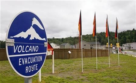
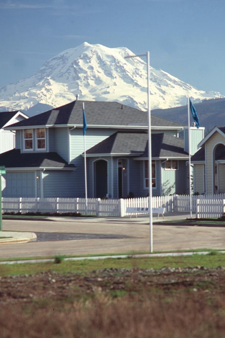
3 Volcanic Hazards & Mt. Rainier Mt. Rainier is the second most active of the Cascade Volcanoes It poses several threats to the Puyallup Valley: Ashfall Pyroclastic Flows Lahars (Volcanic mud/debris flows)

4 What is a Lahar? * Lahars consist of water, mud, rocks and debris that flow rapidly down streams and rivers * Eruptions, quakes or even a spring thaw can trigger lahars * Can reach Puyallup Valley communities within minutes


5 Prior Examples of Deadly Lahars 1980 Mt. St. Helens eruption sent lahars 50 miles, destroying 27 bridges and nearly 200 homes 1985 Nevado del Ruiz eruption in Colombia killed 20,000 people in the town of Armero


6 A Population At-Risk >150,000 residents now live on top of old lahar deposits Residents will need to evacuate to higher ground if a lahar warning is issued Increasing population and limited access roads present a risk
7 More Residents, Greater Risk
8 Detection, Warning, and Evacuation Plan USGS & Pierce County, WA set up first fully automated detection & warning system in 1998 Sensors record ground vibration and trigger alerts to emergency agencies If warning is issued, residents evacuate to high ground along prescribed routes Success depends on public understanding of risk and responding appropriately and promptly to warnings

9 What determines the success of such emergency plans? Do people feel the risk is real? Are they aware of details of the warning system & evacuation plan? Do they believe the plan will work? How will they react when a warning is actually issued?
10 Prior Research & Educational Campaigns at Mt. Rainier Johnston et al. (2001) conducted several assessments of risk perception among school children in Orting, Washington Since 2001, USGS, local educators, and emergency management personnel have been increasing their efforts to educate the public about lahar hazards and the evacuation plan, but there has been no assessment of the effectiveness of these efforts
11 Purpose of the Present Study This study was a first attempt to assess risk perception, awareness of and confidence in the warning and evacuation plan among at-risk, adult residents living close to Mt. Rainier We also saw this as an opportunity to build upon our own prior work on perceptions of risk and confidence in evacuation plans regarding: Volcanic eruptions at Etna and Vesuvius in Italy (Davis et al., 2005) Tsunami hazards in Washington State (Johnston et al., 2002) and in northern California (Davis, 2006).
12 Method Participant Recruitment Procedure * A total of 712 surveys were distributed by trained volunteers from May - August, 2006 * Canvassing of neighborhoods, distribution at safety fairs and farmers markets in Orting, Puyallup and nearby communities * Surveys were returned by mail in businessreply envelopes.
13 Method Participants * 257 residents returned and completed surveys (Response rate of 36%) * 65% Female, 35 % Male * Age: years (M = 51.8, SD = 15.2) * 92% Home Owners, 7% Renters * 35% were high school graduates, 46% had a college degree, 14% an advanced degree
 * 37 Items (Rating Scales and Open-Ended) - perceived risk regarding lahar hazard - knowledge of lahar warning system - awareness of")
14 Method Survey Measure (adapted from Johnston et al., 2001) * 37 Items (Rating Scales and Open-Ended) - perceived risk regarding lahar hazard - knowledge of lahar warning system - awareness of appropriate response - confidence in evacuation routes - self-efficacy and information-seeking
15 Results: Perceived Risk Large proportion of residents see lahars as a potential threat: 57% Lahars threaten my personal safety. 67% Lahars threaten my home or property. Few residents are in denial of risk: 14% Lahar risk has been exaggerated. 10% There may be a lahar but it won t be that bad
 sirens will indicate approaching lahar (n = 177) Media will broadcast alerts (n = 19) 70% know that they are to evacuate to higher ground or use official evacuation routes in")
16 Results: Warning System & Response 82% of residents were aware of the warning system for their community Of these, significant numbers were able to describe important elements of the system: sensors will relay data (n = 43) sirens will indicate approaching lahar (n = 177) Media will broadcast alerts (n = 19) 70% know that they are to evacuate to higher ground or use official evacuation routes in response to warnings
17 Results: Evacuation Plan * Over 50% said they have actually followed the official evacuation route for their town * Only 31% of respondents believe that the official evacuation routes are adequate * Most commonly voiced concerns were: Too many people/too few routes, traffic jams, panic (82%) It is too far to evacuate on foot (5%) Poorly marked evacuation routes (3%)
18 Results: Evacuation Plan 45% of the sample admitted that they have considered using an evacuation route that is different from the official route Official routes will be too congested (n = 60) Know a faster/closer/easier route (n = 26) Desire for other alternatives (n = 13) Relatively few respondents (4%) said they will require help to evacuate: disabilities, transportation issues, small children.
19 Results: Concerns of Parents 30% (n = 76) of those sampled have children in grades K 12 Of these, 73% are aware that their child s school has a lahar evacuation plan 31% do not trust the school s evacuation plan to protect their children from a lahar 39% plan to go to the school to get their children if a warning is issued

20 Results: Self Efficacy and Information-Seeking Extremely Low Low Moderate High Extremely High 5 0 Self-Efficacy Intend to Seek Info?
21 Conclusions/Implications Consistent with findings from our work in Italy (volcanic risk), and in Washington & California (tsunami), most residents close to Mt. Rainier: see lahars as a threat to their safety and property demonstrate no real evidence of denial demonstrate moderate to low levels of self-efficacy regarding their ability ro protect themselves believe that evacuation plans are inadequate and have little faith in the success of these plans feel that local government officials as not wellprepared to deal with a crisis plan to use their own evacuation routes or to ignore aspects of the official plan (i.e. going to schools)
22 Conclusions/Implications Public s lack of faith in evacuation plans and the often slow process of educating the public may stem from not bringing residents into the discussion; there is a need for community-based educational campaigns Emergency management officials often plan evacuations and develop educational campaigns without consulting with social scientists, who can shed light on how the public might respond

23 What would you do? Will residents follow official recommendations that are counter-intuitive or which are unrealistic? Does leaving citizens out of the planning and decision-making process contribute to feelings of low self-efficacy?
24 A plea for greater involvement by social scientists... The vast majority of past studies on response to natural hazards have been done without input by social scientists When social scientists do conduct research on this topic, they tend to focus on after-effects like PTSD, rather than on pre-disaster preparedness A recent international conference (Cities on Volcanoes 4) in 2006 called for greater interdisciplinary research among geologists, social scientists, and emergency management officials
25 Special thanks to... The Department of Emergency Management, Pierce County, Washington for providing the funding for this project Students volunteers Samantha Mitchell, Kate Wilson, Nick Schuur, and Kim Batayola of Dominican University of California for their help with survey preparation, mailing and coding
The Orting Community College of Vulcanology
 The Orting Community College of Vulcanology A Recommendation For His Honourable Mayor A. Young By DAG (Doom-and-Gloom), LLP (Michael, Chris, Bryan, Lauren, Dave) Agenda 1. 2. 3. 4. 5. 6. Description of
Predicting and Preparing for Volcanoes
 Predicting and Preparing for Volcanoes Prediction methods for volcanic eruptions are more reliable than those for earthquakes. Some volcanoes such as Mount Etna in Italy are monitored all of the time because
Safety Procedures for Volcanic Activity in the United States and Japan
 Parkland College A with Honors Projects Honors Program 2015 Safety Procedures for Volcanic Activity in the United States and Japan Ashley Eisenmenger Parkland College Recommended Citation Eisenmenger,
Orting Community College Proposal
 Orting Community College Proposal Cedric, Celina, Francine, Sarah, Samuel GEO CORP Located in Washington, 42 miles south of Seattle. Situated between two rivers on fertile plains. Built on lahar deposits.
b. Why is the area affected by each earthquake circular or nearly circular? Where is the epicenter of each quake located?
 Name: Skill Sheet 29-A Interpreting Geologic Hazard Maps Plate tectonics and the weather are often the cause of geologic hazards such as earthquakes, volcanic eruptions, and flooding. Geologic hazard events
A New College in Orting?
 A New College in Orting? Risk Report and Recommendation by: Safe Schools Kause Everyone Deserves (SSKED) 2017 Geographic location and physical site of Orting The city of Orting is located in Pierce county,
GEOLOGY 285: INTRO. PETROLOGY
 Dr. Helen Lang Dept. of Geology & Geography West Virginia University FALL 2005 GEOLOGY 285: INTRO. PETROLOGY Mount St. Helens 1980 Eruption Small earthquakes Small steam and ash eruptions in March and
Interpretive Map Series 24
 Oregon Department of Geology and Mineral Industries Interpretive Map Series 24 Geologic Hazards, and Hazard Maps, and Future Damage Estimates for Six Counties in the Mid/Southern Willamette Valley Including
Land-use planning and volcanic hazards: Opportunities for New Zealand
 Land-use planning and volcanic hazards: Opportunities for New Zealand Julia Becker, Wendy Saunders, Graham Leonard, David Johnston, Lower Hutt Clare Robertson, Massey University, Palmerston North Presentation
Also, when Cascade volcanoes do erupt, high-speed avalanches of pyroclastic flows
 INTRODUCTION A volcano is a vent through which molten rock escapes to the Earth s surface. Unlike other mountains, which are pushed up from below, volcanoes are built by surface accumulation of their eruptive
 Hazard Warnings GE 4150 Natural Hazards September 17, 2007 http://www.sdr.gov/ndis_rev_oct27.pdf Sorensen, J.H. (2000) Hazard warning systems: Review of 20 years of progress. Natural Hazards Review, May,
Hazard Resilience Index (HRI) Earthquakes, Tsunamis, and Volcanoes
 Earthquakes, Tsunamis, and Volcanoes") Hazard Index (HRI) Earthquakes, Tsunamis, and Volcanoes Earthquakes Tsunamis Volcano-Ash Falls, Projectiles and Lateral Blasts, Pyroclastic Flows and Lava Flows Earthquakes, Tsunamis and Volcanoes Please
Hazard Index (HRI) Earthquakes, Tsunamis, and Volcanoes Earthquakes Tsunamis Volcano-Ash Falls, Projectiles and Lateral Blasts, Pyroclastic Flows and Lava Flows Earthquakes, Tsunamis and Volcanoes Please
Volcanoes. Introduction
 Volcanoes Introduction Display Slide V-0 Explain that a volcano is a vent through which molten rock escapes to the Earth s surface. Unlike other mountains, which are pushed up from below, volcanoes are
Cyber Enabled Earth Exploration (CE )
") Cyber Enabled Earth Exploration 3 (CE ) Field Notebook Module 1: Introduction to Volcanoes Investigation 1: Volcanic Hazards and Benefits Table of Contents Folder 1: Mount Vesuvius, Italy... 3 Folder 2:
Cyber Enabled Earth Exploration 3 (CE ) Field Notebook Module 1: Introduction to Volcanoes Investigation 1: Volcanic Hazards and Benefits Table of Contents Folder 1: Mount Vesuvius, Italy... 3 Folder 2:
Preparing for Eruptions What will happen in future eruptions and how can we be prepared?
 Lesson Plan 12 Activities 1. Read or listen to Matt s Volcano Story from What s the Plan Stan Stories on: http://www.whatstheplanstan.govt.nz/teacher.html#disasters Discuss what Matt saw and did before,
Kadovar Eruption: Multi-Hazard Monitoring and Response
 2018/SOM1/EPWG/016 Agenda Item: 11.10 Kadovar Eruption: Multi-Hazard Monitoring and Response Purpose: Information Submitted by: Papua New Guinea 13 th Emergency Preparedness Working Group Meeting Port
Rapid Geospatial Assessment Creating a Lahar Vulnerability Index for Mount Rainier, Washington
 I. Findings: Rapid Geospatial Assessment Creating a Lahar Vulnerability Index for Mount Rainier, Washington Drew Thompson 5/11/2011 GEOG594A Spring 2011 Dr. Bacastow Based on 2010 US Census bureau figures,
GENERAL. CHAPTER 1 BACKGROUND AND PURPOSE OF THE GUIDELINES Background of the Guidelines Purpose of the Guidelines...
 GENERAL CHAPTER 1 BACKGROUND AND PURPOSE OF THE GUIDELINES... 1 1.1 Background of the Guidelines... 1 1.2 Purpose of the Guidelines... 3 CHAPTER 2 APPLICATION OF THE GUIDELINES... 3 2.1 Potential Users
Debris Avalanches. Debris avalanche deposits on a volcano in Chile. All of the area in the foreground is buried by a thick debris avalanche.
 Debris Avalanches Volcanoes are not very stable structures. From time to time, they collapse producing large rock and ash avalanches that travel at high speeds down valleys. Collapse maybe caused by an
Released Science Inquiry Task Encounter with an Active Volcano Grade 11
 Date: Your Name: Released Science Inquiry Task Encounter with an Active Volcano 2016 Grade 11 Directions: Science You will be reading a story and analyzing the data provided to answer a set of questions.
Volcanoes and Urban Planning
 Background Reading & Lesson Plan Document ID: 10_04_04_1 Date Received: 2004-10-04 Date Revised: 2004-11-16 Date Accepted: 2004-11-23 Curriculum Topic Benchmarks: M1.3.5, M3.3.17, M5.3.3, M9.3.2, S12.3.7,
GEOLOGY 285: INTRO. PETROLOGY
 Dr. Helen Lang Dept. of Geology & Geography West Virginia University SPRING 2015 GEOLOGY 285: INTRO. PETROLOGY The Cascade Volcanoes are a good example of the Circum- Pacific ring of fire of subductionrelated
Mount St. Helens. Copyright 2010 LessonSnips
 Mount St. Helens Washington State is home to the Cascade Mountains, a range of mountains that extends from the Canadian province of British Columbia to northern California. Many of these mountains are
Volcanoes. Volcanoes July 2004
 Volcanoes Learn about your community s risk from hazards created by volcanic eruptions. While you may be located far from a volcano, the ash from an explosive eruption could affect your area. Contact your
Erupted and killed approximately 15,000 people 200 years ago
 1 2 3 4 5 6 7 8 Introduction to Environmental Geology, 5e Chapter 8 Volcanic Activity Volcanoes: summary in haiku form A volcano forms. Magma comes to the surface - explodes, if felsic. Case History: Mt.
Homework III. Volcanological Exercises
 Page 1 of 5 EENS 3050 Tulane University Natural Disasters Prof. Stephen A. Nelson Homework III. Volcanological Exercises This page last updated on 16-Feb-2018 1. In your work as an insurance company executive
AND. A GEOMORPHOLOGIST SVIEWS HERMAN Th. VERSTAPPEN. International Institute for Geoinformation. Enschede the Netherlands
 NATURAL DISASTER REDUCTION AND ENVIRONMENTAL MANAGEMENT A GEOMORPHOLOGIST SVIEWS HERMAN Th. VERSTAPPEN Em. Professor of Geomorphology International Institute for Geoinformation Science and Earth Observation
Emergency Action Guidelines for NH 4-H Animal Events
 Emergency Action Guidelines for NH 4-H Animal Events Purpose: This plan outlines guidelines designed to help ensure NH 4-H Animal Events and Shows are prepared for emergencies and severe weather conditions.
Severe Weather Hazards Are Real
 Severe Weather Hazards Are Real In the past 10 years, more than 40 people have died and dozens more injured as a result of weatherrelated events in Minnesota (not including motor vehicles.) The top severe
New Topic Today. Mass Movement = Mass Wasting. =colluvial processes =slope processes =slope failures =LANDSLIDES. Landslides by U.S.
 New Topic Today Mass Movement = Mass Wasting =colluvial processes =slope processes =slope failures =LANDSLIDES U.S. Landslide Risk Which states have lots of landslide damage? Landslides by U.S. Region
LECTURE #11: Volcanoes: Monitoring & Mitigation
 GEOL 0820 Ramsey Natural Disasters Spring, 2018 LECTURE #11: Volcanoes: Monitoring & Mitigation Date: 15 February 2018 I. What is volcanic monitoring? the continuous collection of one or more data sources
Emergency Preparedness Questions
 Emergency Preparedness Questions 1. A family emergency plan should NOT include which of the following? a) Information about your children's school(s) b) The name and phone number of an out-of-town contact
Unit 5: NWS Hazardous Weather Products. Hazardous Weather and Flooding Preparedness
 Unit 5: NWS Hazardous Weather Products Objectives Describe the mission of the NWS Describe the basic organizational structure of the NWS Explain the purpose of various NWS products Explain how Probability
FIRST GRADE HAZARDS 1 WEEK LESSON PLANS AND ACTIVITIES
 FIRST GRADE HAZARDS 1 WEEK LESSON PLANS AND ACTIVITIES PLATE TECTONIC CYCLE OVERVIEW OF FIRST GRADE VOLCANOES WEEK 1. PRE: Learning the shapes of volcanoes. LAB: Experimenting with "lava." POST: Comparing
GUIDELINES FOR CONSTRUCTION TECHNOLOGY TRANSFER DEVELOPMENT OF WARNING AND EVACUATION SYSTEM AGAINST SEDIMENT DISASTERS IN DEVELOPING COUNTRIES
 GUIDELINES FOR CONSTRUCTION TECHNOLOGY TRANSFER DEVELOPMENT OF WARNING AND EVACUATION SYSTEM AGAINST SEDIMENT DISASTERS IN DEVELOPING COUNTRIES MARCH 2004 Ministry of Land, Infrastructure and Transport
Progress Report. Flood Hazard Mapping in Thailand
 Progress Report Flood Hazard Mapping in Thailand Prepared By: Mr. PAITOON NAKTAE Chief of Safety Standard sub-beuro Disaster Prevention beuro Department of Disaster Prevention and Mitigation THAILAND E-mail:
Common Core Reading Passage
 Directions: Please read the following Common Core Reading passage and answer the questions that follow. Common Core Reading Passage Forecasting Severe Weather to Communities Helps Them Prepare By Alissa
Nevado Del Ruiz, Lahars
 Nevado Del Ruiz, 1985 - Lahars Lecture Objectives -Basics of lahars: definition, characteristics -Ruiz case study: hazards, impacts Mt. Pinatubo lahar footage by Mike Dolan (MTU) Mt. Pinatubo lahar footage
The Three Things You Need to Know About Tsunami Preparedness Patrick Corcoran, Oregon Sea Grant,
 The Three Things You Need to Know About Tsunami Preparedness Patrick Corcoran, Oregon Sea Grant, 10.11.13 NSF/CEETEP Workshop for Coastal Educators, October 11-14, Astoria, OR The Bottom Line Giant Earthquakes
"The Big One" by sea and not by land
 "The Big One" by sea and not by land By Los Angeles Times, adapted by Newsela staff on 03.24.14 Word Count 629 Surfer Lee Johnson emerges from the water at San Onofre State Beach, Calif., with the twin
SCIENCE OF TSUNAMI HAZARDS
 SCIENCE OF TSUNAMI HAZARDS ISSN 8755-6839 Journal of Tsunami Society International Volume 29 Number 3 2010 POTENTIAL DEFICIENCIES IN EDUCATION, INSTRUMENTATION, AND WARNINGS FOR LOCALLY GENERATED TSUNAMIS
2013 Tornado and Severe Weather Awareness Drill
 2013 Tornado and Severe Weather Awareness Drill Scheduled for Thursday April 18, 2013 The 2013 Tornado Drill will consist of a mock tornado watch and a mock tornado warning for all of Wisconsin. This is
Perception of Earthquake Risk and Postdisaster
 Perception of Earthquake Risk and Postdisaster Reconstruction: Comparative Study of Two Residential Neighborhoods on Different Socio-economic Status in Tehran Seyed Ali Badri University of Tehran, sabadri@ut.ac.ir
3/7/17. #16 - Case Studies of Volcanoes II. Announcements Monday 2/27
 Announcements Monday 2/27 Exam #1: Monday Feb. 27 th, 7:15-8:15 (see web site) Last Names A - N Loomis 141 Last Names O - Z Loomis 151 Bring your student ID An old exam is posted in Compass If you are
IN-PLACE SHELTER ANNEX. For TORNADO EMERGENCIES
 Annex C Delaware County IN-PLACE SHELTER ANNEX For TORNADO EMERGENCIES Table Of Contents I. Introduction 2 II. Purpose 2 III. Background 2 IV. General Procedures 3 A. For Residents With Home Basements
Extreme Temperature Protocol in Middlesex-London
 Clean Air Partnership Webinar March 17, 2009 Extreme Temperature Protocol in Middlesex-London Presented by Iqbal Kalsi, MBA, CPHI(C), CCEP iqbal.kalsi@mlhu.on.ca 1 History Informal monitoring, tracking
Aim: To be able to describe and explain techniques used to predict or reduce the impacts of volcanic eruptions in NAMED locations.
 C/W Qu: Can we predict volcanoes? 18/10/12 Aim: To be able to describe and explain techniques used to predict or reduce the impacts of volcanic eruptions in NAMED locations. Starter: Read and correct the
FROM SCIENCE TO ACTION: THE RISK ANALYST INTERMEDIARY
 FROM SCIENCE TO ACTION: THE RISK ANALYST INTERMEDIARY Gordon Woo Rome, 8 October, 2014 Many natural hazard stakeholders Civil protection, police and military authorities Infrastructure utility and transport
Location Option Details. 1. Florida
 1. Florida Florida has the smallest number of earthquaes in the United States. Florida is the U.S. location where hurricanes are most frequent. Of the six deadliest hurricanes to hit the continental U.S.,
2/25/2013. Volcanoes: summary in haiku form A volcano forms. Magma comes to the surface - explodes, if felsic.
 Introduction to Environmental Geology, 5e Edward A. Keller Chapter 8 Volcanic Activity Volcanoes: summary in haiku form A volcano forms. Magma comes to the surface - explodes, if felsic. Lecture Presentation
Scientists: Explosive eruption risk rises for Hawaii volcano 10 May 2018, by Sophia Yan And Audrey Mcavoy
 Scientists: Explosive eruption risk rises for Hawaii volcano 10 May 2018, by Sophia Yan And Audrey Mcavoy Hawaii Gov. David Ige said a geothermal energy plant near the lava outbreak was accelerating its
City of Punta Gorda Community Emergency Management Plan 2013
 City of Punta Gorda Community Emergency Management Plan 2013 Hurricane Andrew- August 24, 1992 Category 5 hurricane. The second-most-destructive hurricane in U.S. history. The first named storm of the
Shelter in Place Warning (SPW) A warning of an event where the public is recommended to immediately shelter in place (go inside, close doors and
 A warning of an event where the public is recommended to immediately shelter in place (go inside, close doors and") Shelter in Place Warning (SPW) A warning of an event where the public is recommended to immediately shelter in place (go inside, close doors and windows, turn off air conditioning or heating systems, and
Shelter in Place Warning (SPW) A warning of an event where the public is recommended to immediately shelter in place (go inside, close doors and windows, turn off air conditioning or heating systems, and
COMMUNITY EMERGENCY RESPONSE TEAM FLOODS INTRODUCTION
 INTRODUCTION Floods are one of the most common hazards in the United States. A flood occurs any time a body of water rises to cover what is usually dry land. Flood effects can be local, impacting a neighborhood
What is a tsunami? Capital Regional District Tsunami Frequently Asked Questions (FAQ s) Tsunami (soo-nah-mee)
 Tsunami (soo-nah-mee)") Tsunami (soo-nah-mee) Tsunamis (Japanese translation harbour wave ) are waves with a great distance between crests, and are caused by any widespread, sudden movement of large volumes of water. The tsunami
Tsunami (soo-nah-mee) Tsunamis (Japanese translation harbour wave ) are waves with a great distance between crests, and are caused by any widespread, sudden movement of large volumes of water. The tsunami
Lessons learnt from 2014 Mt Ontake and 2000 Mt Usu eruptions: findings from a post-eruption ballistic impact assessment trip to Japan
 Lessons learnt from 2014 Mt Ontake and 2000 Mt Usu eruptions: findings from a post-eruption ballistic impact assessment trip to Japan Rebecca Fitzgerald, Ben Kennedy, Thomas Wilson, Graham Leonard, Kae
MITIGATION OF THE IMPACT OF TORNADOES IN THE CANADIAN PRAIRIES
 12th Annual Canadian Risk and Hazards Network Symposium Coast Plaza Hotel, Calgary, Alberta MITIGATION OF THE IMPACT OF TORNADOES IN THE CANADIAN PRAIRIES BY: SAMANTHI W. DURAGE (PhD) PROFESSOR S.C. WIRASINGHE
GLG Ch 6: Volcanoes & Volcanic Hazards. 3. Name, describe (DSC) and draw the three types of volcanoes from smallest to largest.
 and draw the three types of volcanoes from smallest to largest.") GLG 101 - Ch 6: Volcanoes & Volcanic Hazards Name 6.1 What Is and and Is Not a Volcano? 1. Three common characteristics of a volcano include A B C 2. How did the Hopi Buttes (figure 06 01.b1) form? 3.
GLG 101 - Ch 6: Volcanoes & Volcanic Hazards Name 6.1 What Is and and Is Not a Volcano? 1. Three common characteristics of a volcano include A B C 2. How did the Hopi Buttes (figure 06 01.b1) form? 3.
Natural Processes. Were you prepared for the fast approaching storm? Were you able to take shelter? What about pets, livestock or plants?
 Have you ever been caught in a storm? You are outside on a summer night and all of a sudden here come the wind, lightning and heavy rain. It starts raining so hard that you can hardly see in front of you.
Bomb Threat Risk Factors Prevention Strategies White level inspections
 Bomb Threat Bomb threats may occur at schools or colleges and campuses due to a range of risk factors. Workplaces should be prepared to respond to bomb threats in an effective and appropriate way. Risk
National Weather Service 1
 National Weather Service 1 National Weather Service Source: FEMA 2 The Need for a Robust/Diverse Severe Weather Plan Presidential Disaster Declarations 2015 Kentucky Disaster Declarations DR-4216 (Feb
SCHOOL EMERGENCY MANAGEMENT PLAN FOR NATURAL DISASTERS
 SCHOOL EMERGENCY MANAGEMENT PLAN FOR NATURAL DISASTERS MANAGING EMERGENCIES EFFECTIVELY Keith Thomas, Loss Prevention & Risk Manager LEADERSHIP, ADVOCACY AND SERVICE FOR MANITOBA S PUBLIC SCHOOL BOARDS
The Nuts and Bolts of These Community Preparedness Recognition Programs
 The Nuts and Bolts of These Community Preparedness Recognition Programs Bill Sammler Warning Coordination Meteorologist NOAA s National Weather Service, Wakefield VA http://weather.gov/akq Why is StormReady
Betty Hearn Morrow Consulting Sociologist Professor Emerita, Florida International University
 Betty Hearn Morrow Consulting Sociologist Professor Emerita, Florida International University 2018 WMO RA-IV Workshop on Hurricane Forecasting and Warning National Hurricane Center - Miami, Florida 8 March
Tahlequah Public Schools Inclement Weather Transportation Plan
 Tahlequah Public Schools Inclement Weather Transportation Plan Inclement Weather with Ice and Snow From time to time throughout the school year, weather may force a change in the District s normal operating
Hayden Island. i t. a u. p e. e k. By your Neighborhood Emergency Team
 Hayden Island n o i t a r a p e r P e k a u q h Eart By your Neighborhood Emergency Team Who are Hayden Island Nets? Your neighbors Completed 30 hr training from Fire Bureau and Portland Emergency Management
New Topic Today. Mass Movement = Mass Wasting. =colluvial processes =slope processes =slope failures =LANDSLIDES. Landslides by U.S.
 New Topic Today Mass Movement = Mass Wasting =colluvial processes =slope processes =slope failures =LANDSLIDES U.S. Landslide Risk Which states have lots of landslide damage? Landslides by U.S. Region
Mt St Helens was know to have entered into active periods that lasted from years once every years over the last 500 years, (Figure 5).
.") Lecture #8 notes; Geology 3950, Spring 2006; CR Stern May 1980 eruption of Mt St Helens volcano (text pages 183-192 in the 4 th edition and 206-222 in the 5 th edition) Mt St Helens in southwest Washington
Lecture #8 notes; Geology 3950, Spring 2006; CR Stern May 1980 eruption of Mt St Helens volcano (text pages 183-192 in the 4 th edition and 206-222 in the 5 th edition) Mt St Helens in southwest Washington
Risk Management Strategy
 Risk Management Strategy 1 Purpose To protect the component parts of the World Heritage property as well as the lives and the property of visitors and residents from disasters such as volcanic eruptions,
Jeopardy. Final Jeopardy $100 $100 $100 $100 $100 $200 $200 $200 $200 $200 $300 $300 $300 $300 $400 $400 $400 $500 $500 $500 $500 $500
 Jeopardy Earthquakes Volcanoes Tsunamis Wildfires Landslides/ Droughts $100 $100 $100 $100 $100 $200 $200 $200 $200 $200 $300 $300 $300 $300 $300 $400 $400 $400 $400 $400 $500 $500 $500 $500 $500 Final
NATURAL HAZARDS MODULE
 NATURAL HAZARDS MODULE Table of Content Vocabulary... 86 Background Infromation... 87 Introduction... 89 Group activity... 90 Worksheets: Oral history... 93 Written history... 95 Mordern planning... 96
Annex B Natural No-Notice Event
 Annex B Natural No-Notice Event Version: 1.0 Effective: 10/01/2015 Revision Date: 10/01/2015 Approved By: John Pitcher Purpose The purpose of Natural No-Notice Event Annex is to ensure the safety of BHCC
Tornado Drill Exercise Plan (EXPLAN)
") Tornado Drill Exercise Plan (EXPLAN) As part of the National Weather Service s (NWS) Severe Weather Preparedness Week in Indiana Purdue University March 19, 2019 As of Feb 19, 2019 TABLE OF CONTENTS Introduction...
Tornado Drill Exercise Plan (EXPLAN) As part of the National Weather Service s (NWS) Severe Weather Preparedness Week in Indiana Purdue University March 19, 2019 As of Feb 19, 2019 TABLE OF CONTENTS Introduction...
VISIT MISSISSIPPI GULF COAST CRISIS COMMUNICATION MANUAL 2016
 VISIT MISSISSIPPI GULF COAST CRISIS COMMUNICATION MANUAL 2016 This manual was prepared for Visit Mississippi Gulf Coast staff in the event of a crisis, and will help to distinguish the appropriate course
WHAT HAPPENS WHEN A TORNADO STRIKES THE COMMUNITY? Carroll County Sheriff s Office Emergency Management
 WHAT HAPPENS WHEN A TORNADO STRIKES THE COMMUNITY? Carroll County Sheriff s Office Emergency Management WHAT IS EMERGENCY MANAGEMENT? Carroll County Sheriff s Office Emergency Management Agency is responsible
CHAPTER GEOLOGICALLY HAZARDOUS AREAS Applicability Regulations.
 CHAPTER 19.07 GEOLOGICALLY HAZARDOUS AREAS 19.07.010 Applicability. Geologically hazardous areas may pose a threat to the health and safety of citizens when incompatible development is sited in areas of
EMERGENCY WARNING SYSTEM PROCEDURES FOR DEBRIS FLOWS IN WESTERN OREGON
 EMERGENCY WARNING SYSTEM PROCEDURES FOR DEBRIS FLOWS IN WESTERN OREGON Updated: 12/03/2007 by the Oregon Department of Forestry and the Oregon Department of Geology and Mineral Industries Debris flows
City of Norman Hazard Mitigation Plan Public Input Survey Norman, Oklahoma. Table of Contents
 City of Norman Hazard Mitigation Plan Public Input Survey Norman, Oklahoma Table of Contents Introduction... 2 Survey Results... 3 Examples of Recruitment Information... 23 Paper Survey / Web Survey...
Press Release. March 12, 2018
 COUNTY EXECUTIVE OFFICE 105 E. Anapamu St., Fourth Floor, Santa Barbara CA 93101 (805) 568-3400 FAX (805) 568-3414 Contact: Santa Barbara County Joint Information Center 805-696-1188 Media Only Press Release
A dirty-bomb is going to explode sometime tomorrow and destroy your company 4ever. You have been warned. 9/24/ :41 pm
 BOMB THREATS RESPONSE 1 Preparedness 2 3 Hey @yourbusiness. A dirty-bomb is going to explode sometime tomorrow and destroy your company 4ever. You have been warned 9/24/2017 11:41 pm What we envision 4
Exploring Social Capital in Busan and Gimhae, Korea:
 Exploring Social Capital in Busan and Gimhae, Korea: Perspectives from Social Trust and Social Risk Kazuo Ueda 1. Introduction My field of research is Risk Management and Insurance at Senshu University.
Flood Hazard Map - a tool for comprehensive flood management-
 Flood Hazard Map - a tool for comprehensive flood management- Kenzo Hiroki National Institute for Land and Infrastructure Management Ministry of Land, Infrastructure and Transport Flood Hazard (Awareness)
Debris flow: categories, characteristics, hazard assessment, mitigation measures. Hariklia D. SKILODIMOU, George D. BATHRELLOS
 Debris flow: categories, characteristics, hazard assessment, mitigation measures Hariklia D. SKILODIMOU, George D. BATHRELLOS Natural hazards: physical phenomena, active in geological time capable of producing
Introduction to Environmental Geology, 5e Case History: Indonesian Tsunami Indonesian Tsunami (2) Introduction Historic Tsunamis
 Introduction Historic Tsunamis") 1 2 3 4 5 6 7 8 9 Introduction to Environmental Geology, 5e Chapter 7 Tsunami Case History: Indonesian Tsunami December 26, 2004, within a few hours, close to 250,000 people were killed With no warning
1 2 3 4 5 6 7 8 9 Introduction to Environmental Geology, 5e Chapter 7 Tsunami Case History: Indonesian Tsunami December 26, 2004, within a few hours, close to 250,000 people were killed With no warning
United States Multi-Hazard Early Warning System
 United States Multi-Hazard Early Warning System Saving Lives Through Partnership Lynn Maximuk National Weather Service Director, Central Region Kansas City, Missouri America s s Weather Enterprise: Protecting
Source:
 Source: http://www.pastforward.ca/perspectives/columns/10_02_05.htm At 16:53, on Wednesday, January 12th, 2010, a devastating 7.0 earthquake struck Haiti's capital, Port-au-Prince. The earthquake left
New Findings Form Basis for Earthquake
 Page 1 of 5 enter key Advanced Se Español Français Pycckuú You Are In: USINFO > Products >Washfile 10 November 2005 New Findings Form Basis for Earthquake Warning System Tracking quake waves could give
Floods. Floods COMMUNITY EMERGENCY RESPONSE TEAM FLOODS CONTENT INSTRUCTOR GUIDANCE
 Floods Floods Introduce this topic by explaining that floods are one of the most common hazards in the United States. A flood occurs any time a body of water rises to cover what is usually dry land. Display
New Pig Corporation newpig.com HOT-HOGS Page 1 of 10
 Develop a Disaster Preparedness Plan Assess your risks of natural and manmade disasters Purchase adequate insurance and ensure that you have the types of coverage you may need Keep employee contact information
and their risks A look at volcano risk for young students. Produced by the MED-SUV project.
 and their risks A look at volcano risk for young students. Produced by the MED-SUV project. Volcano Shapes: A volcano is a place (on Earth and OTHER PLANETS) where magma comes to the surface. This event
HURRICANE PREPAREDNESS GUIDE
 HURRICANE PREPAREDNESS GUIDE BE PREPARED! TABLE OF CONTENTS Basic Preparedness Tips... 3 Preparing Your Home... 4 What To Do... 5 Make a Hurricane Plan... 6 Important Information... 7 pacu.com 800.433.7228
The General Public s Weather Information-Seeking and Decision-Making Behavior during Tornado Outbreaks in the Oklahoma City Metroplex in May 2013
 The General Public s Weather Information-Seeking and Decision-Making Behavior during Tornado Outbreaks in the Oklahoma City Metroplex in May 2013 Chen Ling, Michelle Madison, Jessica Adams, Kevin Warren,
Surviving the Big One: Understanding and Preparing for a Major Earthquake in Western Oregon
 Surviving the Big One: Understanding and Preparing for a Major Earthquake in Western Oregon May 21, 2013 City of Salem Salem Public Library Althea Rizzo, Geological Hazards Program Coordinator Oregon Emergency
State Of Wisconsin. Department of Military Affairs. Division of Emergency Management
 State Of Wisconsin Department of Military Affairs Division of Emergency Management Brian M. Satula Administrator Scott Walker Governor For more information contact: Tod Pritchard Office: 608-242-3324 Cell:
GEOL1 Physical Geology Laboratory Manual College of the Redwoods Lesson Five: Volcanoes Background Reading: Volcanoes Volcanic Terms: Silca:
 Name: Date: GEOL1 Physical Geology Laboratory Manual College of the Redwoods Lesson Five: Volcanoes Background Reading: Volcanoes Volcanic Terms: Silca: SiO 2 silicon dioxide. This is quartz when it crystallizes.
Of topic specific knowledge and understanding To encourage progressive development in 'thinking geographically'
 [August 2012] Content exemplars 1. Broad description of the content: Single paragraph, written with technical precision Content rigour (avoiding generic statements) Identifying the core of essential knowledge
Deadly Earthquake Strikes Peru
 Deadly Earthquake Strikes Peru KEY POINTS On 14 January 2018, a magnitude-7.1 earthquake struck off the coast of Peru. At least two people have been reported dead, with dozens more left injured or homeless.
A Multi-Agency Approach to Ash-Fall Preparedness and Response in Alaska
 A Multi-Agency Approach to Ash-Fall Preparedness and Response in Alaska Christina Neal Volcanologist U.S. Geological Survey Alaska Volcano Observatory Anchorage, AK Originally Presented November 2012:
CANBERRA SECONDARY SCHOOL Preliminary Examination 2
 CANBERRA SECONDARY SCHOOL 2015 Preliminary Examination 2 Secondary Four (Normal Academic) COMBINED HUMANITIES 11 August 2015 Geography Elective (2194/02) 1 hour 40 minutes 10.30 12.10 Name: ( ) Class: