Activities Related to Disaster Management for Earthquake In Bangladesh
|
|
|
- Barrie Lawrence
- 6 years ago
- Views:
Transcription
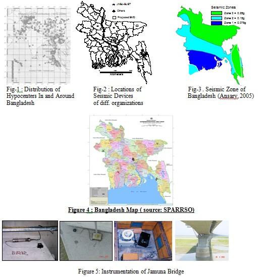
1 Activities Related to Disaster Management for Earthquake In Bangladesh I. ABSTRACT Ms. Suraiya Begum & Md. Shah Alam, Principal Scientific Officer, Bangladesh Space Research & Remote Sensing Organization (SPARRSO) & Prof. Dr. Mehedi Ahmed Ansari, Bangladesh University of Engineering & Technology (BUET) Earthquakes are related to faulting and tectonic instability of an area. Lying in the confluence of India Burme-Eurishya plate; Bangladesh is extremely prone to earthquake. A strong earthquake affecting the major cities like Dhaka, Sylhet, Chittagong, may result in severe damage and long term consequences for the entire country. Different organizations like Ministry of Disaster Management & Relief (MDMR), Disaster Management Bureau (DMB), National Center for Earthquake Eng.(NCEE), Bangladesh Meteorological Dept.(BMD),Bangladesh University of Eng. & Technology (BUET), University of Dhaka(DU), Chittagong University of Eng. & Technology etc. play a major role in earthquake risk mitigation to help the economic planning and Sustainable development of the country. In this paper, a brief summary of activities related to earthquake undertaken in Bangladesh have been presented. Key words: Awareness, Disaster Management, Hazards, Mitigation II. INTRODUCTION Bangladesh has an alluvial deltaic land with Himalayas on its north and Bay of Bengal on its south. It is located between N to N Lat and E to E Lon. It has an area of about 1, 47,570 sq,km with population more than 140 million. Most of its area is relatively flat lying in the deltaic plain of the Ganges-Brahmaputra- Meghna river system. Due to its geographic location and population density, it experiences diff. types of natural disasters which cause losses to lives and properties every year. Earthquake is the worst of them. The overall tectonics of Bangladesh and adjoining region is convective for frequent and recurring earthquakes. The geo-tectonic setting of the country is seismically very active. The adverse impact of all natural and man-made disasters needs to be reduced for sustainable development of the country. Consequently, it is needed to prepare against all possible disasters. III. EARTHUAKE ZONES OF BANGLADESH Bangladesh is divided into 3 earthquake zones : Zone 1: the less risky zone (includes Jessore, Khulna, Barisal and Noakhali Dist.) Zone 2 : medium vulnerable zone (includes Dhaka,Chittagong,Rajshahi, Dinajpur and Bogra Dist Zone 3 : the most vulnerable zone ( includes Sylhet,Mymensingh and Rangpur Districts. Fig-3 shows the zones.(source: Ansary,2005) IV. EARTHQUAKE AFFECTING IN BANGLADESH Bangladesh is a part of Bengal basin which is one of the most seismically active zone of Asian countries. It experienced some of worst earthquakes in the past which causes damage to cities of > RJSITM: Volume: 02, Number: 02, December-2012 Page 9
2 Sylhet, Chittagong Srimangal, Dhaka etc. Table-1 shows some remarkable earthquake affecting in and around Bangladesh and Fig-1 shows the hypocenters of them. (Source: internet) Table 1: Some remarkable Earthquakes affecting in Bangladesh Date Name( Place) Magnitude in Rihcter Epicenter distance from Dhaka (km) 14-Jul-1885 Bengal earthquake (Bogra ) Jul-1918 Srimangal Earthquake ( Srimangal) May-1997 Sylhet Earthquake (Sylhet ) Nov-1997 Chittagong Earthquake (Chittagong) Jul-1999 Moheskhali Earthquake (Cox;s Bazar ) Jul-2003 Chittagong Rangamati Earthquake Aug-2006 Fridpur Earthquake Aug-2007 Chandpur Earthquake Nov-2007 Bandarban Earthquake Sep-2008 Hajiganj Earthquake Mar-2008 ManikgonjEarthquake Sep-2010 HajiganjEarthquake Jun-2011 Faridpur Earthquake Aug-2011 ChandpurEarthquake Mar-2012 DoharEarthquake V. PARAMETERS OF EARTHQUAKE Generally, the tectonic movement of the earth s plates which forms the thin outer shell of the earth s crust causes earthquake. It is a geological hazard. There are mainly 4 measures for earthquake: (source: internet) Magnitude Intensity Epicenter Depth Magnitude measures the energy released which is generally based on the Richter scale measurements. Intensity measures the scale of damage or casualty of the disaster. VI. CATAGORY OF EARTHQUAKE According to the magnitude, the Earthquakes are normally categorized as: (Source: BMD) Very Minor (Less than 3 in Richter Scale ) Minor ( in Richter Scale ) Light ( in Richter Scale ) Moderate ( in Richter Scale ) Strong ( in Richter Scale ) Major ( in Richter Scale ) Great (8.00 or More in Richter scale ) > RJSITM: Volume: 02, Number: 02, December-2012 Page 10
3 VII. DISASTER MANAGEMENT GOB has undertaken a lot of plans and programs and formulated a set of mechanism for effective and systematic disaster management to mitigate the sufferings of disaster, for the sustainable development of the country. These are: Establishment of Ministry of Disaster management & Relief ( MDMR ),the Govt. coordinator which is responsible for all activities regarding all types of disasters. Establishment of disaster management organization named Disaster Management Bureau (DMB) Establishment of Council & Committee upto union level to maintain proper coordination among the concerned departments and and community people and to ensure their proper functioning. Establishment of Emergency Operation Center for collect information about the disaster during the emergency period. Establishment of Task Force to operate awareness programs. For the mechanisms to be best operative, the Standing Orders on Disaster (SOD) act as a guidebook. (Country Report: DMB). Besides these, SPARRSO, Bangladesh has taken some projects for strengthening capability of disaster monitoring systems for better disaster management towards sustainable development. VIII. ORGANIZATION RELATED TO EARTHQUAKE MANAGEMENT Disaster mitigation and management is not the responsibility of govt. alone or any specific organization or agency. It requires skilled human resources and well-coordinated efforts from all concerned bodies as well as the public. These are: Ministry of Disaster Management & Relief (MDMR) Disaster Management Bureau (DMB) Bangladesh Meteorological Dept. (BMD) Bangladesh Earthquake Society (BES) Directorate of Relief and Rehabilitation (DRR) Red Crescent Society (RCS) Bangladesh Space Research & Remote Sensing Organization (SPARRSO) Water Development Board (WDB) Geological Survey of Bangladesh (GSB ) Bangladesh University of Engineering & Technology (BUET ) Dept. of Geology of Dhaka University Public Works Dept. (PWD) Armed Forces Div.(AFD) NGO's etc. IX. EARTHQUAKE MANAGEMENT/MITIGATION The casualty and damage due to an earthquake can be reduced by suitable mitigation, measures which are categorized as: 1) Structural 2) Non-structural In order to reduce the consequences of major earthquake in the city of Bangladesh, it is necessary to give equal importance to both Structural and Non-Structural mitigation measures. > RJSITM: Volume: 02, Number: 02, December-2012 Page 11
4 IX.B. Structural mitigation Structural measures are those that directly influence the building stock through strengthening of code provisions and the prevalent constructions practice. As part of structural measures GOB has So far constructed shelters nearby the highly vulnerable areas. Set up a committee in 1992 to prepare Building Code setting the minimum standard which had to be met to construct any building. Public Works Department (PWD) arranged several in-house workshops to train their engineers about earthquake, to use the seismic codes in designing buildings. Dept. of Geology of Dhaka University has started the vulnerability assessment of their existing buildings to prioritize their retrofitting measures. IX.C. Non-Structural mitigation The non-structural mitigation measures include improvement in the state of awareness, preparedness, and other activities before and after disaster. IX.C.1. Awareness / Preparedness Preparedness/awareness requires monitoring, workshop/seminars as well as community based management. Monitoring Though Earthquake is rather difficult to predict, Bangladesh Meteorological Dept (BMD) has installed the Digital Seismic Equipment for earthquake monitoring which has 4 components: Broadband seismometer at 4 stations (Dhaka, Chittagong, Rangpur and Sylhet Districts ) Borehole Seismometer at 2 stations upto a depth of 100m( Dhaka and Rangpur Districts ) Short Period Seismometer at 2 stations ( Chittagong and Sylhet Districs ) Strong motion Accelerometer at 4 stations (Dhaka, Chittagong, Sylhet and Rangpur dist.) Fig-2 shows their locations. The data obtained from these seismometers and accelerometers are being processed and analyzed to find out the following parameters of the earthquake: Location ( Lat/Lon ) Magnitude ( Richter Scale) Origin Time Focal Depth These observed data /massage are sent to New Delhi Regional Telecom Hub (RTH) and to the local concerned offices, by Global Telecommunication System (GTS ). BMD share these data with BUET, DU, GSB, PMO via radio modem. Besides this, Bangladesh has the following earthquake monitoring systems: Geohazard research group of Dept. Geology of Dhaka University in cooperation with USA, installed a broadband seismometer in Dhaka and several GPS devices at some places of Bangladesh for earthquake monitoring. > RJSITM: Volume: 02, Number: 02, December-2012 Page 12
5 Bangladesh University of Engineering & Technology (BUET ) installed seven free-field seismic instruments on Jamuna Bridge and on its surrounding areas ( east and west end of the bridge, at Dhaka, Gazipur,Bogra and Nator Dist.(Fig-5). In addition, they installed a borehole accelerograph at 57m. depth. BUET also acquired 60 analog SMA-1 type Accelerograph (Fig-6) installed at different Govt. institutions of the country to acquire earthquake data to develop the attenuation laws for Bangladesh, which can be readily used for earthquake hazard analysis and updating of seismic zonation map. Workshop/Seminar/project Disaster Management Bureau (DMB) with the help of different international funding agencies and local administration and other organizations like Bangladesh University of Engineering & Technology (BUET), Bangladesh Earthquake Society (BES), Bangladesh Academy of Sciences (BAS), Dhaka University (DU), Bangladesh Meteorological Dept. (BMD), Chittagong University of Engineering & Technology (CUET), Bangladesh Red Crescent Society (BDRCS), Local Govt. Engineering dept (LGED), BRAC University, Institute of Engineers Bangladesh (IEB), Institute of Diploma Engineers Bangladesh (IDEB), Real Estate Housing Association of Bangladesh (REHAB), SPARRSO,CARE Bangladesh etc. organized and conducted diff. types of workshop, seminar, symposium and other public awareness and earthquake preparedness programs throughout the country. Community based management Govt. alone cannot properly manage and handle all types of disasters. It requires active participation of local people to provide necessary service during and after the disaster. This new approach of managing disaster known as Community-Based -Approach (CBA), is going on and popularized gradually. BUET has undertaken several projects related to earthquake vulnerability assessment and community awareness. They also started earthquake safety ( mock drill) training to diff. school students (Fig-7). Disaster Management Bureau (DMB) also has published a Disaster Management Training Manual for public awareness guidelines. IX.C.2 Other activities/policies Mapping /Survey Geological Survey of Bangladesh (GSB) is involved with survey and the development of seismic zonation maps for pre and post disaster management. Dept. of Civil Engineering of BUET and SUST undertaken field survey in diff. cities and collected the infrastructure information of diff. existing buildings. For future seismic events and mitigation, BUET and Shah Jalal University of Science & Technology (SUST) prepared microzonation maps of major cities to know local site conditions Fig-8 shows microzonation map of Dhaka. CARE Bangladesh has developed a seismic risk scenario for diff. cities.. Research /Institutional Activities Dept. of Geology of Dhaka University has got funding from Ministry of science and Technology to carryout researches in the field of earthquake hazard assessment. BUET has also undertaken diff. types of research activities related to earthquake. > RJSITM: Volume: 02, Number: 02, December-2012 Page 13
6 Department of Civil Engineering of BUET has established a National Center for Earthquake Engineering (NCEE) and offers Postgraduate courses on earthquake Engineering, Soil Dynamics, Structural Dynamics and Vibration Analysis. Directorate of continuing education, BUET, Institute of Engineers Bangladesh (IEB) has conducted short courses on Earthquake resistant design and Retrofitting of building Institute of Diploma Engineers Bangladesh (IDEB) has offered several courses on earthquake vulnerability and seismic design of structures. Relief /Rehabilitation The damage/losses due to any disaster as well as earthquake is assessed by Disaster Management Bureau (DMB ) and Ministry of Disaster Management & Relief (MDMR ). They are responsible operate relief activities and medical assistance for the victim people with the help of concerned agencies. Armed Forces Div.(AFD) also activate Disaster Management and Relief Monitoring Cell in Prime Minister s Office and monitor rescue operation after any disaster. XI. Conclusion Bangladesh is one of the disaster (earthquake) prone country with extremely limited resources. The development of the country is not possible without the integration of disaster management which is dependent upon awareness and early warning. Pre-disaster planning is much more useful than a post disaster management. All Societies at risk of natural disasters require greater awareness of the threats they face and need appropriate education and training to mitigate the hazards. Realizing these facts, Bangladesh is striving hard to establish an elaborate and systematic disaster management system. For this reason, we need to have a system and facility of advanced technology for Early Warning and Monitoring earthquake. International cooperation and mutual collaboration is necessary for that. Ref: 1) Internet source 2) Bangladesh Meteorology Dept. Data 3) Disaster Management in Bangladesh(country report-2003) 4) World Environment Day(disaster prevention: earthquake) 5) Periodic Briefing session on Earthquake Disaster Management(DMB) > RJSITM: Volume: 02, Number: 02, December-2012 Page 14

7 > RJSITM: Volume: 02, Number: 02, December-2012 Page 15
COUNTRY PRESENTATION ON MR JAYNAL ABEDIN JOINT SECRETARY ( WORKS & DEVELOPMENT ) MINISTRY OF DEFENCE
 MINISTRY OF DEFENCE") COUNTRY PRESENTATION ON By MR JAYNAL ABEDIN JOINT SECRETARY ( WORKS & DEVELOPMENT ) MINISTRY OF DEFENCE Bangladesh Geographical Location of Bangladesh Bangladesh Country at a Glance Physical Features 1,230
COUNTRY PRESENTATION ON By MR JAYNAL ABEDIN JOINT SECRETARY ( WORKS & DEVELOPMENT ) MINISTRY OF DEFENCE Bangladesh Geographical Location of Bangladesh Bangladesh Country at a Glance Physical Features 1,230
Project on Seismic Hazard & Vulnerability. areas, Bangladesh. Mohammad Ashraful Kamal (Geologist)
") Project on Seismic Hazard & Vulnerability Assessment in Dhaka, Chittagong & Sylhet city areas, Bangladesh By Mohammad Ashraful Kamal (Geologist) Tectonic & Seismic zoning map of Bangladesh Geological map
Project on Seismic Hazard & Vulnerability Assessment in Dhaka, Chittagong & Sylhet city areas, Bangladesh By Mohammad Ashraful Kamal (Geologist) Tectonic & Seismic zoning map of Bangladesh Geological map
EARTHQUAKE FORECASTING IN BANGLADESH AND ITS SURROUNDING REGIONS
 EARTHQUAKE FORECASTING IN BANGLADESH AND ITS SURROUNDING REGIONS B. K. Chakravorti Department of Physics, Begum Rokeya University, Rangpur, Bangladesh M. Kundar Department of Physics, Jagannath University,
DIPLOMA IN DISASTER MANAGEMENT. (Non-Semester) (With effect from the academic year )
 (With effect from the academic year )") DIPLOMA IN DISASTER MANAGEMENT (Non-Semester) (With effect from the academic year 2013-14) Eligibility for the Course Candidate should have passed the Higher Secondary Examination conducted by the Board
DIPLOMA IN DISASTER MANAGEMENT (Non-Semester) (With effect from the academic year 2013-14) Eligibility for the Course Candidate should have passed the Higher Secondary Examination conducted by the Board
Disaster Risk Reduction in Survey for Seismic Protection of MES
 Survey for Seismic Protection Ministry of Emergency Situations of Republic of Armenia Disaster Risk Reduction in Survey for Seismic Protection of MES Syuzanna Kakoyan Leading specialist at the Department
CORRELATION BETWEEN TEMPERATURE CHANGE AND EARTHQUAKE IN BANGLADESH
 CORRELATION BETWEEN TEMPERATURE CHANGE AND EARTHQUAKE IN BANGLADESH A. Hossain *, F. Kabir & K. Roy Department of Civil Engineering, Rajshahi University of Engineering & Technology, Rajshahi, Bangladesh
SEISMIC RISK ASSESSMENT IN ARMENIA
 SEISMIC RISK ASSESSMENT IN ARMENIA Hovhannes Khangeldyan Head of National Crisis Management Center Rescue Service Ministry of Emergency Situations of the Republic of Armenia Tokyo, 2016 ARMENIA: GEOGRAPHICAL
Status and Challenges on Geo-DRM Information Systems in Tonga
 Name: Mafua- i-vai utukakau Maka Status and Challenges on Geo-DRM Information Systems in Tonga 1 Roles and Relationships Land and Geographic Information Systems (LGIS) Unit: Establish updated high-resolution
Georeferencing and Satellite Image Support: Lessons learned, Challenges and Opportunities
 Georeferencing and Satellite Image Support: Lessons learned, Challenges and Opportunities Shirish Ravan shirish.ravan@unoosa.org UN-SPIDER United Nations Office for Outer Space Affairs (UNOOSA) UN-SPIDER
Lecture-06: Disasters of Bangladesh: Earthquakes
 URP 4243: Hazards and Disaster Management Lecture-06: Disasters of Bangladesh: Earthquakes 50 1 Course Teacher: Md. Esraz-Ul-Zannat Assistant Professor Dept. of URP, KUET January 18, 2018 ACKNOWLEDGEMENT
- facilitate the preparation of landslide inventory and landslide hazard zonation maps for the city, - development of precipitation thresholds,
 Date of Submission 29.03.2012 IPL Project Proposal Form 2012 (MAXIMUM: 3 PAGES IN LENGTH) 1. Project Title: (2 lines maximum)-introducing Community-based Early Warning System for Landslide Hazard Management
The Case of the El Nino
 Page 1 of 5 Reducing the Impact of Environmental Emergencies Through Early Warning and Preparedness The Case of El Niño-Southern Oscillation (ENSO) Home >> Bangladesh Executive Summary Bangladesh Country
PROBABILISTIC EXTREMES OF THE FREQUENCY OF THUNDERSTORM DAYS OVER BANGLADESH DURING THE PRE- MONSOON SEASON
 225 PROBABILISTIC EXTREMES OF THE FREQUENCY OF THUNDERSTORM DAYS OVER BANGLADESH DURING THE PRE- MONSOON SEASON Samarendra Karmakar Bangladesh Meteorological Department, Sher-e-Bangla Nagar, Agargaon Dhaka-1207,
Republic of Mozambique
 Republic of Mozambique Second Expert's Symposium on Multi-Hazard Early Warning Systems with focus on the Role of National Meteorological and Hydrological Services 5-7 May 2009, Toulouse France 1. Background
EARTHQUAKE IN BANGLADESH: A NATURAL DISASTER AND PUBLIC AWARENESS
 EARTHQUAKE IN BANGLADESH: A NATURAL DISASTER AND PUBLIC AWARENESS A. A. Khan 1, M. Hoque 1, S. H. Akhter 1 & M. A. Hoque 1 ABSTRACT: The nature and the distribution of the earthquake events in different
Community: An Asset to reduce landslide risk. Prepared by: Azra Jawaid Jafreen Alamgir
 Community: An Asset to reduce landslide risk Prepared by: Azra Jawaid Jafreen Alamgir Map of Bangladesh Map of Bangladesh. Google Images. Web. 25 Sep. 2014 Chittagong at a view Situated at the bank of
Disaster Prevention and Management in Asia: The Context of Human Security and Its Relevance to Infrastructure Planning and Management
 Disaster Prevention and Management in Asia: The Context of Human Security and Its Relevance to Infrastructure Planning and Management Rajib Shaw http://www.iedm.ges.kyoto-u.ac.jp/ Contents Background and
5. Principles. 1. Malaysia is not free from. Kuala Teriang, Langkawi
 5. Principles 1. Malaysia is not free from seismic-induced geohazards. However, the degree and magnitude of the geohazards are relatively small or minor because Malaysia is located in a stable tectonic
GENERAL. CHAPTER 1 BACKGROUND AND PURPOSE OF THE GUIDELINES Background of the Guidelines Purpose of the Guidelines...
 GENERAL CHAPTER 1 BACKGROUND AND PURPOSE OF THE GUIDELINES... 1 1.1 Background of the Guidelines... 1 1.2 Purpose of the Guidelines... 3 CHAPTER 2 APPLICATION OF THE GUIDELINES... 3 2.1 Potential Users
RISK OF PRINCIPAL DISASTERS IN INDIA AND IMPACTS OF DISASTERS ON ECONOMIC DEVELOPMENT
 RISK OF PRINCIPAL DISASTERS IN INDIA AND IMPACTS OF DISASTERS ON ECONOMIC DEVELOPMENT At the Himachal Pradesh Institute of Public Administration Shimla 05. 05.2012 Improve Disaster Management with the
REAL-TIME ASSESSMENT OF EARTHQUAKE DISASTER IN YOKOHAMA BASED ON DENSE STRONG-MOTION NETWORK
 REAL-TIME ASSESSMENT OF EARTHQUAKE DISASTER IN YOKOHAMA BASED ON DENSE STRONG-MOTION NETWORK Saburoh MIDORIKAWA 1 And Susumu ABE 2 SUMMARY This paper describes a system for REal-time Assessment of earthquake
Impact of Cyclone Nargis
 Lessons Learnt from Nargis Recovery for the Next Disaster International Recovery Forum (2011) 12, JAN 2011, Kobe, Japan Home for over 100 national races. Profile of Myanmar The 2 nd largest country in
Overview of Early Warning Systems and the role of National Meteorological and Hydrological Services
 Overview of Early Warning Systems and the role of National Meteorological and Hydrological Services South Africa Second Experts Symposium on Multi-Hazard Early Warning Systems With focus on the Role of
Available online Journal of Scientific and Engineering Research, 2018, 5(3): Research Article
: Research Article") Available online www.jsaer.com, 2018, 5(3):166-180 Research Article ISSN: 2394-2630 CODEN(USA): JSERBR Impact of Climate Variability on Human Health- A Case Study at Kanchanpur Union, Basail, Tangail District,
Available online www.jsaer.com, 2018, 5(3):166-180 Research Article ISSN: 2394-2630 CODEN(USA): JSERBR Impact of Climate Variability on Human Health- A Case Study at Kanchanpur Union, Basail, Tangail District,
FLOOD HAZARD MAPPING OF DHAKA-NARAYANGANJ-DEMRA (DND) PROJECT USING GEO-INFORMATICS TOOLS
 PROJECT USING GEO-INFORMATICS TOOLS") FLOOD HAZARD MAPPING OF DHAKA-NARAYANGANJ-DEMRA (DND) PROJECT USING GEO-INFORMATICS TOOLS Md. Aminul Islam MEE07178 Supervisor: Prof. Kuniyoshi TAKEUCHI ABSTRACT Dhaka-Narayanganj-Demra (DND) Project is
FLOOD HAZARD MAPPING OF DHAKA-NARAYANGANJ-DEMRA (DND) PROJECT USING GEO-INFORMATICS TOOLS Md. Aminul Islam MEE07178 Supervisor: Prof. Kuniyoshi TAKEUCHI ABSTRACT Dhaka-Narayanganj-Demra (DND) Project is
Progress Report. Flood Hazard Mapping in Thailand
 Progress Report Flood Hazard Mapping in Thailand Prepared By: Mr. PAITOON NAKTAE Chief of Safety Standard sub-beuro Disaster Prevention beuro Department of Disaster Prevention and Mitigation THAILAND E-mail:
Flood Management in Japan
 Flood Management in Japan 1. Comprehensive Flood Control Measures 2. Provision of River information 3. Responses to the Niigata Torrential Rain Disaster 4. About ICHARM 5. Responses to 2011 Thailand Floods
JICA s Experiences of Connecting Japanese Science & Technologies for Disaster Risk Reduction in Developing Countries
 JICA s Experiences of Connecting Japanese Science & Technologies for Disaster Risk Reduction in Developing Countries Junji WAKUI Deputy Director General, Group Leader Disaster Risk Reduction Group Global
EARTH OBSERVATION SERVICES IN REPUBLIC OF MOLDOVA
 EARTH OBSERVATION SERVICES IN REPUBLIC OF MOLDOVA Vasile ALCAZ 1 Ion APOSTOL 2 1 Institute of Geology and Seismology Moldavian Academy of Sciences 2 Ministry of Environment and Natural Resources Republic
Gutenberg-Richter recurrence law to seismicity analysis of Bangladesh
 IABSE-JSCE Joint Conference on Advances in Bridge Engineering-III, August 21-22, 2015, Dhaka, Bangladesh. ISBN: 978-984-33-9313-5 Amin, Okui, Bhuiyan, Ueda (eds.) www.iabse-bd.org Gutenberg-Richter recurrence
National Public Weather and Warning Services in the Swaziland Meteorological Service Dennis S.Mkhonta /
 National Public Weather and Warning Services in the Swaziland Meteorological Service Dennis S.Mkhonta dennis.mkhonta@gmail.com / dennis@swazimet.gov.sz Introduction Swaziland s geographical position exposes
Final Presentation on Disaster Risk Management in Japan. Through ADRC V. R Programme. Main Findings and Action Plan:
 Final Presentation on Disaster Risk Management in Japan Through ADRC V. R Programme Main Findings and Action Plan: Problem/Hazard and Disaster in Japan Good Practiced on Disaster Risk Management in Japan
Geohazards and disaster risk reduction
 Geohazards and disaster risk reduction Susanne Sargeant 8 November 2017 Overview University and my PhD Seismology at BGS Learning other skills Working at the interface between science and resilience building
Technical Article TRICOLITE. Pledged to Excellence SAFE, EFFICIENT, RELIABLE POWER DISTRIBUTION SOLUTIONS
 Technical Article SAFE, EFFICIENT, RELIABLE POWER DISTRIBUTION SOLUTIONS EARTHQUAKES & SEISMIC COMPLIANCE OF LV SWITCHGEAR ASSEMBLY Random vibrations, such as those caused by an earthquake, cause shocks
DISATER MANAGEMENT IN LIBRARIES
 DISATER MANAGEMENT IN LIBRARIES by S. Padmashree National Seminar cum Workshop on Trends & Challenges in LIS Education and Profession March 24 25 th 2017 Andhra University, Visakhapatnam Disaster - A
In Issue of International Sabo News Letter
 In Issue of International Sabo News Letter I had an opportunity to make a keynote speech on March 18 2003 at the session on Sedimentrelated Issues at the 3rd World Water Forum held in (Kyoto) Japan. Chairing
JCOMM-CHy Coastal Inundation Forecasting Demonstration Project (CIFDP)
") WMO World Meteorological Organization Working together in weather, climate and water JCOMM-CHy Coastal Inundation Forecasting Demonstration Project (CIFDP) Coastal Flooding & Vulnerable Populations Coastal
WMO World Meteorological Organization Working together in weather, climate and water JCOMM-CHy Coastal Inundation Forecasting Demonstration Project (CIFDP) Coastal Flooding & Vulnerable Populations Coastal
Ground Motion Studies for Critical Sites in North-West Bangladesh
 Science & Technology Conference 2011 Vienna, June 8-10, 2011 Ground Motion Studies for Critical Sites in North-West Bangladesh Dr. Tahmeed M. Al Hussaini Professor of Civil Engineering, Bangladesh University
Country Report Nepal Geospatial Data Sharing Initiatives of Survey Department Supporting Disaster Management
 Third JPTM Step 2 for Sentinel Asia 6-8 July, 2010 Manila, The Philippines Country Report Nepal Geospatial Data Sharing Initiatives of Survey Department Supporting Disaster Management Durgendra M Kayastha
Earthquake Disaster Management in India
 Earthquake Disaster Management in India Akshay B. Ahlawat JRF in Geography Abstract: The fact is that natural disasters are always unexpected events which affect human life as well as nature itself. Earthquakes
UNITED NATIONS E/CONF.97/6/IP. 33
 UNITED NATIONS E/CONF.97/6/IP. 33 ECONOMIC AND SOCIAL COUNCIL Seventeenth United Nations Regional Cartographic Conference for Asia and the Pacific Bangkok, 18-22 September 2006 Item 7 of the provisional
Table G - 6. Mitigation Actions Identified for Implementation by the City of Kent ( ) (From Wilkin County Master Mitigation Action Chart)
 (From Wilkin County Master Mitigation Action Chart)") Table G - 6. Actions Identified by the () (From Master Action Chart) Multi-Hazard Plan, 2017 Action Comments 5 All-Hazards Local Planning & Regulations Update the Operations Plan on an annual basis. Work
Table G - 6. Actions Identified by the () (From Master Action Chart) Multi-Hazard Plan, 2017 Action Comments 5 All-Hazards Local Planning & Regulations Update the Operations Plan on an annual basis. Work
Investigation, assessment and warning zonation for landslides in the mountainous regions of Vietnam
 Investigation, assessment and warning zonation for landslides in the mountainous regions of Vietnam (State-Funded Landslide Project SFLP) Dr. Eng. Le Quoc Hung Add: 67 Chien Thang Street, Ha Dong District,
REGRESSION FORECASTING OF PRE-MONSOON RAINFALL IN BANGLADESH ABSTRACT
 Proceedings of the SAAC Seminar on Agricultural Applications of Meteorology, held on 23-24 December 2003, published by SMC in 2004 EGESSION FOECASTING OF PE-MONSOON AINFALL IN BANGLADESH SAMAENDA KAMAKA
Roadmap to Stability
 Landslide Policy Committee for Aizawl City February 2014 Technical Support by: Aizawl is in earthquake hazard zone V and highly prone to natural, man-made and earthquake induced landslides. In order to
Tsunami Hazard Assessment in the Northern Bay of Bengal
 Tsunami Hazard Assessment in the Northern Bay of Bengal Final Report March 2011 Institute of Water and Flood Management, Bangladesh University of Engineering and Technology Institute of Water Modelling
SPATIO-TEMPORAL CHARACTERISTICS OF RAINFALL AND TEMPERATURE IN BANGLADESH
 SPATIO-TEMPORAL CHARACTERISTICS OF RAINFALL AND TEMPERATURE IN BANGLADESH K. Roy *, M. Kumruzzaman & A. Hossain Department of Civil Engineering, Rajshahi University of Engineering and Technology, Rajshahi,
Management in Surface, Climate and Upper-air Observations in RAII,Tokyo, Assistant Director Bangladesh Meteorological Department
 JMA / WMO Workshop on Quality Management in Surface, Climate and Upper-air Observations in RAII,Tokyo, 27-30 July 2010 Shamsuddin Ahmed Assistant Director Bangladesh Meteorological Department Bangladesh
43rd Session of The WMO/ESCAP PANEL on Tropical Cyclones New Delhi, India May, 2016
 43rd Session of The WMO/ESCAP PANEL on Tropical Cyclones New Delhi, India 02-06 May, 2016 Shamsuddin Ahmed Director Bangladesh Meteorological Department METEOROLOGY Cyclonic Disturbances over the Bay of
Geospatial Information for Disaster Risk Management in Asia-Pacific Region
 Geospatial Information for Disaster Risk Management in Asia-Pacific Region Ram S. Tiwaree, Dr.Eng. Space Applications Section Information and Communications Technology and Disaster Risk Reduction Division
3D Seismic Hazard and Risk Maps for Earthquake Awareness of Citizens with Aids of GIS and Remote Sensing Technologies
 3D Seismic Hazard and Risk Maps for Earthquake Awareness of Citizens with Aids of GIS and Remote Sensing Technologies Saburoh Midorikawa Tokyo Institute of Technology In Japan, seismic hazard and risk
APPLICATIONS OF EARTHQUAKE HAZARD MAPS TO LAND-USE AND EMERGENCY PLANNING EXAMPLES FROM THE PORTLAND AREA
 APPLICATIONS OF EARTHQUAKE HAZARD MAPS TO LAND-USE AND EMERGENCY PLANNING EXAMPLES FROM THE PORTLAND AREA O. Gerald Uba Metro, Portland, Oregon OVERVIEW The extent to which we understand "below ground"
RVO s Mission Statement and some of the Key Result Areas stated below captures some of these alternative best practices.
 PART I. Introduction Rabaul Volcanological Observatory (RVO) is the national institution responsible for monitoring volcanoes Papua New Guinea. It comes under the Department of Mineral Policy and Geohazards
Training System and Information Network for Earthquake Disaster Mitigation. Taiki SAITO. Building Research Institute (BRI)
") 1 Training System and Information Network for Earthquake Disaster Mitigation Taiki SAITO Chief Research Engineer, International Institute of Seismology and Earthquake Engineering (IISEE), Building Research
1 Training System and Information Network for Earthquake Disaster Mitigation Taiki SAITO Chief Research Engineer, International Institute of Seismology and Earthquake Engineering (IISEE), Building Research
Saiful Islam Anisul Haque
 Workshop on Disaster Prevention/Mitigation Measures against Floods and Storm Surges in Bangladesh on 17-21 November, 2012, in Kyoto University, Japan Component 2: Flood disaster risk assessment and mitigation
National Seismological Centre: An Overview, Prospects and Challenges
 National Seismological Centre: An Overview, Prospects and Challenges By Soma Nath Sapkota Department of Mines and Geology National Seismological Centre Nepal India Himalaya Tibetan Plateau India continental
Overview of Disaster
 Overview of Disaster Management: Bangladesh Perspective By Md Shah Kamal Secretary Ministry of Disaster Management & Relief Country Profile: Bangladesh Total population : 165 million Total Geographic Area
Analysis of Historical Pattern of Rainfall in the Western Region of Bangladesh
 24 25 April 214, Asian University for Women, Bangladesh Analysis of Historical Pattern of Rainfall in the Western Region of Bangladesh Md. Tanvir Alam 1*, Tanni Sarker 2 1,2 Department of Civil Engineering,
Disaster RISK Management : Bhutanese Scenario
 Disaster RISK Management : Bhutanese Scenario Expert Group Meeting (EGM) on Geo-referenced Information Systems for Disaster Risk Management (Geo-DRM) and sustaining the Community of Practice (COP), Bangkok,
THE STUDY ON 4S TECHNOLOGY IN THE COMMAND OF EARTHQUAKE DISASTER EMERGENCY 1
 THE STUDY ON 4S TECHNOLOGY IN THE COMMAND OF EARTHQUAKE DISASTER EMERGENCY 1 Zhou Wensheng 1, Huang Jianxi 2, Li Qiang 3, Liu Ze 3 1 Associate Professor, School of Architecture, Tsinghua University, Beijing.
"The Natural Disasters, like The Sumatra Tsunami had taught us before -BUT" U Than Myint President Myanmar Engineering Society
 "The Natural Disasters, like The Sumatra Tsunami had taught us before -BUT" U Than Myint President Myanmar Engineering Society Present Day Regional Tectonic Setting of South East Asia Tsunami-generated
Predicting Tsunami Inundated Area and Evacuation Road Based On Local Condition Using GIS
 IOSR Journal of Environmental Science, Toxicology and Food Technology (IOSR-JESTFT) ISSN: 2319-2402, ISBN: 2319-2399. Volume 1, Issue 4 (Sep-Oct. 2012), PP 05-11 Predicting Tsunami Inundated Area and Evacuation
Reading a Map in Any Language. Kathy Sundstedt and Dawn Brown School not available. Content Area (Req.): Geography Unit (Opt.):
: Geography Unit (Opt.):") Instructional Sequence/Procedure (Req.): 1. Distribute one copy of Bangladesh map, written in Bengali, to each student group. 2. Optional project the same map on the wall from transparency, overhead projector,
Instructional Sequence/Procedure (Req.): 1. Distribute one copy of Bangladesh map, written in Bengali, to each student group. 2. Optional project the same map on the wall from transparency, overhead projector,
Interpretive Map Series 24
 Oregon Department of Geology and Mineral Industries Interpretive Map Series 24 Geologic Hazards, and Hazard Maps, and Future Damage Estimates for Six Counties in the Mid/Southern Willamette Valley Including
Role of Hydro-Met Services in Disaster Risk Management
 Role of Hydro-Met Services in Disaster Risk Management Tshewang Rigzin (Mr) National Centre for Hydrology and Meteorology, Bhutan 30 th November 2017 Outline Vision and Mission Functions related to Disaster
MOZAMBIQUE: Institutional Arrangements and Achievements
 UN-International Strategy for Disaster Reduction Global Platform for Disaster Risk Reduction- First Session MOZAMBIQUE: Institutional Arrangements and Achievements on Implementation of Hyogo Framework
GUIDELINES FOR CONSTRUCTION TECHNOLOGY TRANSFER DEVELOPMENT OF WARNING AND EVACUATION SYSTEM AGAINST SEDIMENT DISASTERS IN DEVELOPING COUNTRIES
 GUIDELINES FOR CONSTRUCTION TECHNOLOGY TRANSFER DEVELOPMENT OF WARNING AND EVACUATION SYSTEM AGAINST SEDIMENT DISASTERS IN DEVELOPING COUNTRIES MARCH 2004 Ministry of Land, Infrastructure and Transport
Strategic Planning of Tuvalu Meteorological Service
 WMO Regional Seminar on Enhancing Service Delivery by National Meteorological & Hydrological Services (NMHSs( NMHSs) ) in RA V Kuala Lumpur, Malaysia, 2 6 April 2007 Strategic Planning of Tuvalu Meteorological
Baldwin County, Alabama
 2015 Baldwin County, Alabama Multi-Hazard Mitigation Plan I. Comprehensive Plan A multi-jurisdiction plan City of Bay Minette City of Daphne Town of Elberta City of Fairhope City of Foley City of Gulf
Land Mass Change along the Bangladesh Coastline
 Land Mass Change along the Bangladesh Coastline Manar Hasan CE 394K.3 Fall 2016 December 2 nd, 2016 Introduction Motivation Bangladesh is a small country in Asia with a massive population. Always somewhere
Guidelines for Site-Specific Seismic Hazard Reports for Essential and Hazardous Facilities and Major and Special-Occupancy Structures in Oregon
 Guidelines for Site-Specific Seismic Hazard Reports for Essential and Hazardous Facilities and Major and Special-Occupancy Structures in Oregon By the Oregon Board of Geologist Examiners and the Oregon
Report of the Working Group 2 Data Sharing and Integration for Disaster Management *
 UNITED NATIONS E/CONF.104/6 ECONOMIC AND SOCIAL COUNCIL Twentieth United Nations Regional Cartographic Conference for Asia and the Pacific Jeju, 6-9 October 2015 Item 5 of the provisional agenda Report
Bhutan Country Report for JPTM 2010 (July, 2010) Department of Disaster Management Ministry of Home & Cultural Affairs Royal Government of Bhutan
 Department of Disaster Management Ministry of Home & Cultural Affairs Royal Government of Bhutan") Bhutan Country Report for JPTM 2010 (July, 2010) Department of Disaster Management Ministry of Home & Cultural Affairs Royal Government of Bhutan 1 Contents of Presentation 1. Disaster Hazards and Underlying
Bhutan Country Report for JPTM 2010 (July, 2010) Department of Disaster Management Ministry of Home & Cultural Affairs Royal Government of Bhutan 1 Contents of Presentation 1. Disaster Hazards and Underlying
Evidence for plate tectonics
 Evidence for plate tectonics See class powerpoint Printed tables 2x essay Qs markschemes Discuss/Evaluate the evidence for plate tectonics Discuss/evaluate the evidence for plate tectonics Essay: To what
Climate Change in Bangladesh: A Historical Analysis of Temperature and Rainfall Data
 Research Paper Climate Change in Bangladesh: A Historical Analysis of Temperature and Rainfall Data Jayanta Kumar Basak 1 *, Rashed Al Mahmud Titumir 2 and Nepal Chandra Dey 3 1 Dept. of Environmental
Seismic Activity and Crustal Deformation after the 2011 Off the Pacific Coast of Tohoku Earthquake
 J-RAPID Symposium March 6-7, 2013 Seismic Activity and Crustal Deformation after the 2011 Off the Pacific Coast of Tohoku Earthquake Y. Honkura Tokyo Institute of Technology Japan Science and Technology
Flood Forecasting in Bangladesh
 Flood Forecasting in Bangladesh Types of Flood ing Flood ing can be divided into two categories: Flood ing in the rivers caused by upstream rise of river stage as well as rainfall in the basin. Overland
THE 3D SIMULATION INFORMATION SYSTEM FOR ASSESSING THE FLOODING LOST IN KEELUNG RIVER BASIN
 THE 3D SIMULATION INFORMATION SYSTEM FOR ASSESSING THE FLOODING LOST IN KEELUNG RIVER BASIN Kuo-Chung Wen *, Tsung-Hsing Huang ** * Associate Professor, Chinese Culture University, Taipei **Master, Chinese
Enhancing Preparedness and Early Warning in Disaster Risk Reduction
 Enhancing Preparedness and Early Warning in Disaster Risk Reduction Fifth Technical Conference on Management of Meteorological and Hydrological Services in Regional Association V at PETALING JAYA, MALAYSIA
Regional EGM on Community of Practice of Georeferenced Information System. for Disaster Risk Management (Geo-DRM) April 2014, Bangkok, Thailand
 April 2014, Bangkok, Thailand") Regional EGM on Community of Practice of Georeferenced Information System for Disaster Risk Management (Geo-DRM) 23-25 April 2014, Bangkok, Thailand Presented By Mukesh Kumar Keshari Ministry of Home Affairs
Regional EGM on Community of Practice of Georeferenced Information System for Disaster Risk Management (Geo-DRM) 23-25 April 2014, Bangkok, Thailand Presented By Mukesh Kumar Keshari Ministry of Home Affairs
Flash flood forecasting and warning infrastructures of National Meteorology and Hydrological Services of Cambodia
 Development and Implementation of the South East Asia Flash Flood Guidance System (SEAFFGS) Ha Noi, Viet Nam, 20-23 November 2017 Flash flood forecasting and warning infrastructures of National Meteorology
WEATHER FORECAST DHAKA
 WEATHER FORECAST DHAKA 21.10.2017 Hourly 1 PM 4 PM 8 PM 11 PM Temp. / Dew Point 26 / 24 26 / 23 26 / 22 26 / 22 Wind 20 km/h S 29 km/h SSW 17 km/h SW 13 km/h WSW Humidity 91% 86% 79% 78% Chance of Precip
Decadal Changes of Rainfall and Temperature Extremes over the different Agro Economical Zones (AEZ) of Bangladesh
 of Bangladesh") Decadal Changes of Rainfall and Temperature Extremes over the different Agro Economical Zones (AEZ) of Bangladesh Professor A.K.M. Saiful Islam Md. Alfi Hasan Institute of Water and Flood Management Bangladesh
Decadal Changes of Rainfall and Temperature Extremes over the different Agro Economical Zones (AEZ) of Bangladesh Professor A.K.M. Saiful Islam Md. Alfi Hasan Institute of Water and Flood Management Bangladesh
STATUS OF HAZARD MAPS VULNERABILITY ASSESSMENTS AND DIGITAL MAPS
 JapanInternational Cooperation Agency STATUS OF HAZARD MAPS VULNERABILITY ASSESSMENTS AND DIGITAL MAPS ANGUILLA REPORT THE CARIBBEAN DISASTER EMERGENCY RESPONSE AGENCY () Table of Contents Page Preface
Introduction. Thematic Mapping for Disaster Risk Assessment in Case of Earthquake FIG Working Week
 Thematic Mapping for Disaster Risk Assessment in Case of Earthquake Silvia MARINOVA, Temenoujka BANDROVA, Mihaela KOUTEVA-GUENTCHEVA, Stefan BONCHEV University of Architecture, Civil Engineering and Geodesy
EFFECTIVE TROPICAL CYCLONE WARNING IN BANGLADESH
 Country Report of Bangladesh On EFFECTIVE TROPICAL CYCLONE WARNING IN BANGLADESH Presented At JMA/WMO WORKSHOP ON EFFECTIVE TROPICAL CYCLONE WARNING IN SOUTHEAST ASIA Tokyo, Japan,11-14 March 2014 By Sayeed
Establishment of WINDS Ground Station in Sri Lanka. By G.K.D. Amarawardena Additional Secretary Ministry of Disaster Management Sri Lanka
 Establishment of WINDS Ground Station in Sri Lanka By G.K.D. Amarawardena Additional Secretary Ministry of Disaster Management Sri Lanka Contents Background SAS Implementation Progress of WINDS establishment
Delimiting the Flood Risk Zones in Cuddalore District, Tamil Nadu, India
 Delimiting the Flood Risk Zones in Cuddalore District, Tamil Nadu, India P. Ravikumar 1, Dr. G. Baskaran 2 1 Research Scholar, 2 Assistant Professor, Department of Geography, University of Madras, Chennai
Indian Ocean Tsunami Warning System: Example from the 12 th September 2007 Tsunami
 Indian Ocean Tsunami Warning System: Example from the 12 th September 2007 Tsunami Charitha Pattiaratchi 1 Professor of Coastal Oceanography, The University of Western Australia Email: chari.pattiaratchi@uwa.edu.au
PREPARE Enhancing PREParedness for East African Countries through Seismic Resilience Engineering
 PREPARE Enhancing PREParedness for East African Countries through Seismic Resilience Engineering EPSRC-GCRF project (2017-2020) 1.36M budget Investigators: Katsu Goda, Adam Crewe, John Macdonald, George
NGIAs' roles in successful disaster response
 The Second UN-GGIM-AP Plenary Meeting NGIAs' roles in successful disaster response Japan Teheran Iran 28 October 2013 Shin-ichi SAKABE, Director of International Affairs Division Geospatial Information
RETA 6422: Mainstreaming Environment for Poverty Reduction Category 2 Subproject
 RETA 6422: Mainstreaming Environment for Poverty Reduction Category 2 Subproject A. Basic Data 1. Subproject Title: Poverty-Environment Mapping to Support Decision Making 2. Country Director: Adrian Ruthenberg
ENGINEERING-SEISMOLOGICAL ASPECTS OF EARTHQUAKE SCENARIO DEVELOPMENT ON THE EXAMPLE OF TASHKENT, UZBEKISTAN
 International Journal of Geology, Earth & Environmental Sciences ISSN: 2277-281 (Online) 218 Vol. 8 (2) May-August, pp. 3-35/Alixanovich ENGINEERING-SEISMOLOGICAL ASPECTS OF EARTHQUAKE SCENARIO DEVELOPMENT
INDIANA ACADEMIC STANDARDS FOR SOCIAL STUDIES, WORLD GEOGRAPHY. PAGE(S) WHERE TAUGHT (If submission is not a book, cite appropriate location(s))
 WHERE TAUGHT (If submission is not a book, cite appropriate location(s))") Prentice Hall: The Cultural Landscape, An Introduction to Human Geography 2002 Indiana Academic Standards for Social Studies, World Geography (Grades 9-12) STANDARD 1: THE WORLD IN SPATIAL TERMS Students
Prentice Hall: The Cultural Landscape, An Introduction to Human Geography 2002 Indiana Academic Standards for Social Studies, World Geography (Grades 9-12) STANDARD 1: THE WORLD IN SPATIAL TERMS Students
IGOS Geohazards: toward an improved use of Earth Observations for Geohazards mitigation
 IGOS Geohazards: toward an improved use of Earth Observations for Geohazards mitigation Scientific and Technical Subcommittee session Vienna, 15th February 2007 Gonéri Le Cozannet IGOS Geohazards Bureau
The World Bank Ecuador Risk Mitigation and Emergency Recovery Project (P157324)
") Public Disclosure Authorized LATIN AMERICA AND CARIBBEAN Ecuador Social, Urban, Rural and Resilience Global Practice Global Practice IBRD/IDA Investment Project Financing FY 2016 Seq No: 2 ARCHIVED on
Public Disclosure Authorized LATIN AMERICA AND CARIBBEAN Ecuador Social, Urban, Rural and Resilience Global Practice Global Practice IBRD/IDA Investment Project Financing FY 2016 Seq No: 2 ARCHIVED on
Doug Kluck NOAA Kansas City, MO National Center for Environmental Information (NCEI) National Integrated Drought Information System (NIDIS)
 National Integrated Drought Information System (NIDIS)") National Integrated Drought Information System (NIDIS) for the Missouri River Basin Drought Early Warning Information System (DEWS) & Runoff Trends in the Missouri Basin & Latest Flood Outlook Doug Kluck
National Integrated Drought Information System (NIDIS) for the Missouri River Basin Drought Early Warning Information System (DEWS) & Runoff Trends in the Missouri Basin & Latest Flood Outlook Doug Kluck
Outline of Guideline for Development and Utilization of Tsunami Disaster Management Map
 Outline of Guideline for Development and Utilization of Tsunami Disaster Management Map Port and Airport Research Institute, Japan The Overseas Coastal Area Development Institute of Japan Ports and Harbours
The Third UN-GGIM-AP Plenary Meeting. Use of Geospatial Information in Disaster and Coordination among NDMA and Relevant Organizations/Stakeholders
 The Third UN-GGIM-AP Plenary Meeting Use of Geospatial Information in Disaster and Coordination among NDMA and Relevant Organizations/Stakeholders Bali Indonesia 10 November 2014 Bernardus Wisnu Widjaja
Country Report: Bangladesh
 The 5th International Coordination Group (ICG) Meeting GEOSS Asian Water Cycle Initiative (AWCI) Tokyo, Japan, 15-18, December 2009 Country Report: Bangladesh Monitoring and forecasting of cyclones SIDR