Reading a Map in Any Language. Kathy Sundstedt and Dawn Brown School not available. Content Area (Req.): Geography Unit (Opt.):
|
|
|
- Delphia Parker
- 5 years ago
- Views:
Transcription
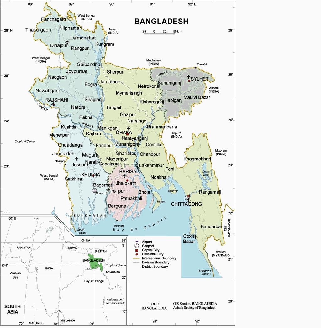
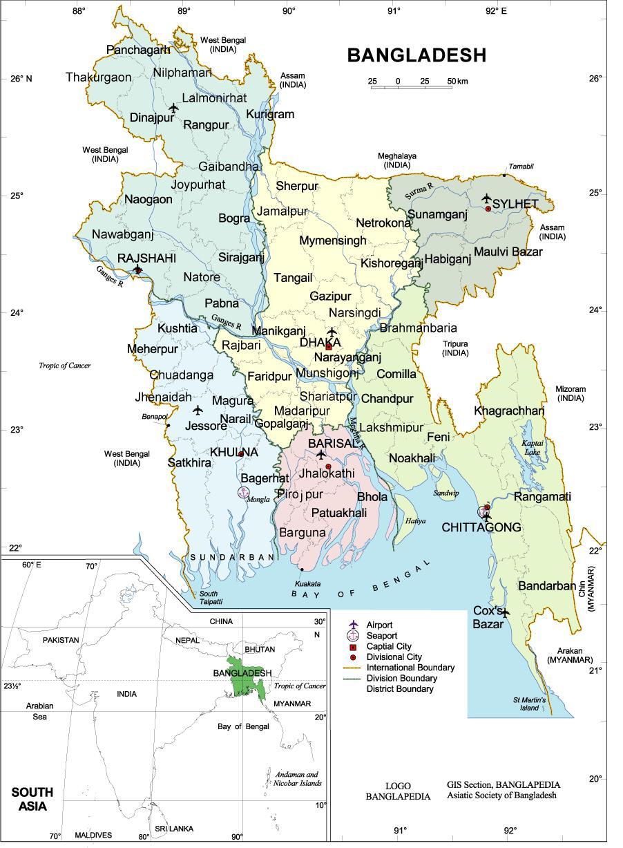
1 Instructional Sequence/Procedure (Req.): 1. Distribute one copy of Bangladesh map, written in Bengali, to each student group. 2. Optional project the same map on the wall from transparency, overhead projector, or computer (see resource below for direct download of computer files of maps). 3. Together, as a class, review T.O.A.D.S. an acronym for typical map contents: Is there a Title on the map (where?)? [Yes, at the top of the page.] What is the Orientation of the map? [Participants can accurately assume north is toward the top of the page.] Who is the Author of the map? [Publisher is GIS section, BANGLAPEDIA, Asiatic Society of Bangladesh.] What is the Date of publication of the map? [Published date is unknown. Accessed date is 8/28/2007.] Discuss the Symbols [in the lower right hand of the page] and Scale [under the title in the upper right hand of the page]. 4. Distribute one worksheet to each group of students. 5. As a class, discuss answers to questions 1-10; extend information. 6. Exchanging of original questions (#11). 7. Enrichment Possibilities: Using Internet resources, or the GAI website, students can create photo essays of each of the districts or specific cities or areas (Rangamati s Kaptai Lake area, the Sundarbans, Chittagong, etc.). 8. Reading a Map in Any Language Kathy Sundstedt and Dawn Brown School not available Grade Level (Req.): 7th-12th grade Content Area (Req.): Geography Unit (Opt.): Connections to Other Disciplines (Opt.): Time Frame (Req.): 1 class period Goal (Req.): Students will be able to accurately read a map. Materials Needed (Req.): Color copies of Bangladesh map, written in Bengali, one copy for each group of students Student worksheets, one copy for each group of students Optional Classroom map of Bangladesh, written in Bengali, for projection onto wall Optional Classroom map of Bangladesh, written in English, for projection onto wall Optional - PowerPoint Objective (Req.): The students will cooperatively use map-reading skills to discover the physical and political geography of Bangladesh. New Vocabulary (Opt.): Anticipatory Set/Introduction [Inquiry Question is required] (Req.): How much can one learn about a country using basic map reading skills, even if the map cannot be read in English?
2 Formative Evaluation (Req.): Class discussion. Assessment (Req.): After completing the map exercise and further discussing the geography of Bangladesh, students can make an acrostic as a summary, using the word Bangladesh. (See sample.) Iowa Core Curriculum Standards Used (Req.): Geography, grade 9-12: Understand the use of geographic tools to locate and analyze information about people, places, and environments. Common Core Curriculum Standards Used (Opt.): Writing, grade 6-12: Produce clear and coherent writing in which the development, organization, and style are appropriate to task, purpose, and audience. NGS Standards Used (Req.): How to use maps and other geographic representations, tools, and technologies to acquire, process, and report information from a spatial perspective
3 Five Themes of Geography Used (Req.): Location Place Region School District Standards and Benchmarks (Opt.): 21 st Century Universal Constructs (Opt.): Complex Communication, Productivity and Accountability Other Disciplinary Standards (Opt.): Other Essential Information (Opt.): NOTE: Printing original maps off websites below will offer better reproduction than copies of maps attached to this lesson. Other Resources (Opt.): ENGLISH VERSION map source: BANGLA VERSION map source:
4 Sample Acrostic B ay of Bengal is in the south A rea includes three main rivers N ot a very large country G oing to have trouble with rivers flooding L ots of small braided rivers A lot of roadless areas in far south D oes not have any snow-capped mountains E veryone depends on river transportation S ea-going ships can come far inland H ot, tropical climate
5 Student Response Sheet: Reading a Map in any Language 1. Identify, using cardinal (N, S, E, W) and intermediate directions (NW, SW, SE, NE) the number and location of countries that border Bangladesh. The gold line around the country may help you 2. For political administration, nations are often divided into states, provinces, or divisions. Count the number of divisions. The green line and colored divisions will help you. 3. Just as you might give the name of your state and county, each division in Bangladesh is further divided into districts. Count the number of districts. The broken gray line will help you. What other clue is there? 4. Reservoirs are human-made lakes created by damming rivers. Water flowing out of reservoirs can be a source of hydroelectric power. Using intermediate directions, describe the location of the division containing a large reservoir. 5. Trace the paths of the three major rivers of Bangladesh. In which cardinal direction do they flow? 6. Take a look at the symbols used for cities. Using those symbols, locate the capital of Bangladesh, Dhaka. Describe the location of the capital. 7. Does there seem to be a connection between the confluence (joining) of those rivers and the location of the capital? Explain. 8. Does every division have an airport? Explain
6 9. In addition to roads, airports, and railroads, what other transportation system is important in Bangladesh? Why would that be an important transportation system? 10. Geographers examine connections. Does one division seem more remote (less connected) than the others? Explain your reasoning. 11. After further map study, develop two original questions to use for class discussion or further research.
7 Teacher s Background: Reading a Map in any Language 1. Identify, using cardinal (N, S, E, W) and intermediate directions (NW, SW, SE, NE) the number and location of countries that border Bangladesh. Two countries border Bangladesh. One (India) is to the west, north and east. A second country (Myanmar/Burma) borders Bangladesh on the southeast. 2. For political administration, nations are often divided into states, provinces, or divisions. Count the number of divisions. Each division is colored pink, yellow, purple, green, etc. There are six divisions: Barisal (Borishal) South Chittagong (Chôţţogram) Southeast Dhaka (Đhaka) North or Central Khulna (Khulna) Southwest Rajshahi (Rajshahi) Northwest Sylhet (Sileţ) Northeast 3. Just as you might give the name of your state and county, each division in Bangladesh is further divided into districts. Count the number of districts. There are 64 districts. Divisions are divided by a broken gray line and districts are identified by name. Barisal (Borishal) South, 6 districts Chittagong (Chôţţogram) Southeast, 11 districts Dhaka (Đhaka) North or Central, 17 districts Khulna (Khulna) Southwest, 10 districts Rajshahi (Rajshahi) Northwest, 16 districts Sylhet (Sileţ) Northeast, 4 districts 4. Reservoirs are human-made lakes created by damming rivers. Water flowing out of reservoirs can be a source of hydroelectric power. Using intermediate directions, describe the location of the division containing a large reservoir. Kaptai Lake is a reservoir located in the southeast, in Rangamati district, Chittagong division.
8 5. Trace the paths of the three major rivers of Bangladesh. In which cardinal direction do they flow? The three rivers flow in a southerly direction, to the ocean. The river systems include: a. from the west, the Padma (called the Ganges inside India); b. from the north, the Jamuna; c. from the north/east, the Brahmaputra/Meghna system. NOTE: From these rivers, annual alluvial deposits are responsible for the fertile soil of Bangladesh. The alluvium deposited from these rivers also creates the many inhabited river islands (called chars "chores"). Most of the rivers in Bangladesh flow from other countries, creating a need for international cooperation. 6. Take a look at the symbols used for cities. Using those symbols, locate the capital of Bangladesh, Dhaka. Describe the location of the capital. The capital, Dhaka, is located in central Bangladesh. 7. Does there seem to be a connection between the confluence (joining) of those rivers and the location of the capital? The capital is located north of the confluence, on slightly higher ground. Most of Bangladesh is located within 30 meters of sea level. 8. Does every division have an airport? Yes. Do some have two? 9. In addition to roads, airports, and railroads, what other transportation system is important in Bangladesh? Why would that be an important transportation system? Ships (and ferries). There are many, many rivers (see #10, too). 10. Geographers examine connections. Does one division seem more remote (less connected) than the others? Answers will vary.
9 11. After further map study, develop two original questions to use for class discussion or further research. Answers will vary.
10
11
12 READING A MAP IN ANY LANGUAGE Kathy Sundstedt and Dawn Brown

13 T.O.A.D.S. Title Orientation Author Date Symbols
14
15
16
Reading a Map in Any Language. Dawn Shattuck NICC; Kathy Sundstedt School not available. Content Area (Req.): Geography Unit (Opt.
: Geography Unit (Opt.") Instructional Sequence/Procedure (Req.): 1. Distribute one copy of Chile map, written in Spanish, to each student group OR direct each group of students to access an online copy of a Chile map. 2. Together,
Instructional Sequence/Procedure (Req.): 1. Distribute one copy of Chile map, written in Spanish, to each student group OR direct each group of students to access an online copy of a Chile map. 2. Together,
Introduction to Egypt
 Instructional Sequence/Procedure (Req.): 1. Assign appropriate reading of text and an introductory take- home quiz about Egypt in anticipation of day 1 of the lesson. The quiz will not be graded, but will
Monsoons: A Three Season Play. Kathy Sundstedt School not available. Content Area (Req.): Physical Geography, English/Reading
: Physical Geography, English/Reading") Instructional Sequence/Procedure (Req.): 1. Teacher preparation: Read through play and consider students for roles. Find yarn and string. Using overhead transparency, make an enlarged map of South Asia
Instructional Sequence/Procedure (Req.): 1. Teacher preparation: Read through play and consider students for roles. Find yarn and string. Using overhead transparency, make an enlarged map of South Asia
Nigeria What is a Region? George Kuhter South Tama County Middle School, Toledo, IA
 Instructional Sequence/Procedure (Req.): 1. Review or introduce the idea of region. The most important idea to stress is that a region is a place or places that have similar physical or human characteristics.
About places and/or important events Landmarks Maps How the land is, hills or flat or mountain range Connected to maps World Different countries
 What do you think you know about geography? About places and/or important events Landmarks Maps How the land is, hills or flat or mountain range Connected to maps World Different countries What do you
Trade in a Long Country. Teacher and School not available. Content Area (Req.): Geography
: Geography") Instructional Sequence/Procedure (Req.): 1. Have students research and learn about the Four Regions of Chile. 2. Have students fill in the attached chart based on researching the four main regions of Chile
Instructional Sequence/Procedure (Req.): 1. Have students research and learn about the Four Regions of Chile. 2. Have students fill in the attached chart based on researching the four main regions of Chile
Parts of a Map. Map Skills. The Title. There are 4 main parts of a map: The Title The Compass Rose The Map Key The Scale
 Map Skills Parts of a Map There are 4 main parts of a map: The Title The Compass Rose The Map Key The Scale The Title The title of the map is usually at the top and describes the topic of the map Example:
Introduction to India. George Kuhter South Tama County Middle School, Toledo, IA
 Instructional Sequence/Procedure (Req.): 1. India: An Introduction Have students read India: An Introduction. After reading this, you may need to discuss some of the information presented in the reading
Many Ways to Name a Place
 Your web browser (Safari 7) is out of date. For more security, comfort and Activityapply the best experience on this site: Update your browser Ignore Many Ways to Name a Place What are the names for the
copyright 2015 White's Workshop
 16 vocabulary cards & pictures 3 printable maps of Florida 2 resource maps of Florida Task cards for political maps Task cards for physical maps Rubrics This packet supports the following Sunshine State
Wayne E. Sirmon GEO 301 World Regional Geography
 Wayne E. Sirmon GEO 301 Geography 301 Geography 301 MAP: A graphic representation of a portion of the earth s surface dawn to scale, as seen from above. Types of Maps Climate maps give general information
Alleghany County Schools Curriculum Guide GRADE/COURSE: World Geography
 GRADE/COURSE: World 2013-14 GRADING PERIOD: 1 st Six Weeks Time Frame Unit/SOLs SOL # Strand Resource Assessment 8 days* The student will use maps, globes, satellite images, photographs, or diagrams to
United States of America Geography
 United States of America Geography Part I by Sonja E. Schild LearnSmart Publishing Co. Vancouver, BC, Canada Phone: (604) 433-1347 ISBN 0-9694445-3-9 Notice! All rights reserved. Permission to reproduce
Your web browser (Safari 7) is out of date. For more security, comfort and. the best experience on this site: Update your browser Ignore
 is out of date. For more security, comfort and. the best experience on this site: Update your browser Ignore") Your web browser (Safari 7) is out of date. For more security, comfort and lesson the best experience on this site: Update your browser Ignore Political Borders Why are the borders of countries located
Your web browser (Safari 7) is out of date. For more security, comfort and lesson the best experience on this site: Update your browser Ignore Political Borders Why are the borders of countries located
GEOGRAPHY. Map Skills. Mrs. Pere ~ 2013
 GEOGRAPHY Map Skills Mrs. Pere ~ 2013 WHAT IS A GLOBE? A globe is a model of the Earth. North Pole Equator South Pole WHAT IS A MAP? A map is a flat drawing of a place. THE IMPORTANT PARTS OF A MAP 1.
Your web browser (Safari 7) is out of date. For more security, comfort and the best experience on this site: Update your browser Ignore
 is out of date. For more security, comfort and the best experience on this site: Update your browser Ignore") Your web browser (Safari 7) is out of date. For more security, comfort and the best experience on this site: Update your browser Ignore Activityengage MAPPING W O RL D HERITAGE Where are sites of significant
Your web browser (Safari 7) is out of date. For more security, comfort and the best experience on this site: Update your browser Ignore Activityengage MAPPING W O RL D HERITAGE Where are sites of significant
Delaware Recommended Curriculum Grade 7 Geography Standard 4b. Authors/Editors: Kristin Schlegel Maggie Legates
 Delaware Recommended Curriculum Grade 7 Geography Standard 4b Authors/Editors: Kristin Schlegel Maggie Legates THIS UNIT WAS ADAPTED FROM BEYOND BORDERS A UNIT FOR MIDDLE GRADES FROM This unit was originally
Canadian Mapping Big Book
 Canadian Mapping Big Book Grades 4-6 Written by Lynda Golletz Illustrated by S&S Learning Materials About the Author: Lynda Golletz was an elementary school teacher for thirty-three years. She is the author
Grade. Why are maps useful? What do maps tell us?
 ACTIVITY 2.1 Follow That DART Bus! DETAILS TYPE Whole-group TIME 20 minutes plus 20 minutes homework (40 minutes total) PRINTED MATERIALS Handouts (Reading A Map, Follow that DART Bus! map and Follow that
What on Earth is Geography? Using the Five Themes of Geography to Study the Continent of Asia.
 What on Earth is Geography? Using the Five Themes of Geography to Study the Continent of Asia. Name Date Essential questions: 1. How can we study the geography of our Earth? a. What are the five themes
Learning Target : Describe the purposes and uses of different types of maps.
 Learning Target : Describe the purposes and uses of different types of maps. Directions: 1. Below, place a where you think you are located. 2. In which continent are you located? 3. In which country are
Milford Public Schools Curriculum
 Milford Public Schools Curriculum Department: Social Studies Grade 3 Course Name: Communities Course Description In third grade, students will engage in a yearlong study of communities and specifically
Why VOCABULARY? clues
 It s GHSGT Time! Why VOCABULARY? Social Studies is all about MAKING CONNECTIONS Key Terms provide relational clues to guide you in answering test questions! The more WORDS you know, the smarter you are
Expanding Canada s Rail Network to Meet the Challenges of the Future
 Expanding Canada s Rail Network to Meet the Challenges of the Future Lesson Overview Rail may become a more popular mode of transportation in the future due to increased population, higher energy costs,
Different types of maps and how to read them.
 Different types of maps and how to read them. A map is a picture or representation of the Earth's surface, showing how things are related to each other by distance, direction, and size. Maps have been
Why Do We Live Here? : A Historical Geographical Study of La Tabatiere, Quebec North Shore
 Why Do We Live Here? : A Historical Geographical Study of La Tabatiere, Quebec North Shore Lesson Overview Many communities and their occupants have historical connections to exploration routes and traditional
5 Themes of Geography Review Video Notes What is Geography?
 Name PG # 5 Themes of Geography Review Video Notes What is Geography? The study of, their, and their Main Idea or Topic Continents Notes about Main Idea or Topic There are 7 Continents or in the world:
Major Languages of the Americas
 Your web browser (Safari 7) is out of date. For more security, comfort and Activitydevelop the best experience on this site: Update your browser Ignore Major Languages of the Americas How are languages
Beginning Orienteering Post visit
 Beginning Orienteering Post visit Classroom Activities Brief Synopsis The post activities are designed to reinforce what the students learned at Eagle Bluff and practice the skill of map reading. Students
Mapping Diversity in Old and New Netherland
 Your web browser (Safari 7) is out of date. For more security, comfort and Activityengage the best experience on this site: Update your browser Ignore Mapping Diversity in Old and New Netherland How did
Essential Questions What are the major physical components of the world, and how are they represented on a map? 3.4
 Third Grade Social Studies Unit One Six Weeks GEOGRAPHY Originally compiled by Russellville In order for students to understand that geography influences the development of a region as well as the interactions
Five Themes of Geography of Ecuador
 LESSON 1 Five Themes of Geography of Ecuador Lesson Objective The students will be able to: find the five themes of geography (location, movement, human/environment interaction, place, and region) of Ecuador
Introduction to Contour Maps
 Your web browser (Safari 7) is out of date. For more security, comfort and Activityengage the best experience on this site: Update your browser Ignore Introduction to Contour Maps What information does
Module 2 Educator s Guide Investigation 2
 Module 2 Educator s Guide Investigation 2 How does remote sensing help us to observe human activities on Earth? Investigation Overview Landscapes that are influenced by human activities are found nearly
Map Skills Unit. Note taking unit
 Map Skills Unit Note taking unit Introduction To learn about the Earth, we are going to learn about two geographic tools you can use.globes and maps. Globe A globe is a round model of the planet Earth
4th Grade US Regional Geography First Nine Weeks
 4th Grade US Regional Geography First Nine Weeks 2014-2015 Identify the choice that best completes the statement or answers the question. 1 The line identified as 0 runs west and east on the globe and
What Is a Globe? Hemispheres. Main Idea Globes and maps provide different ways of showing features of the earth. Terms to Know
 r Main Idea Globes and maps provide different ways of showing features of the earth. Terms to Know hemisphere latitude longitude scale bar scale relief elevation contour line What Is a Globe? A globe is
Activity Plotting Earthquake Epicenters an activity for seismic discovery
 Note: this is not an activity from the TOTLE workshop, but is a good prerequisite to the triangulation activity that follows. Activity Plotting Earthquake Epicenters an activity for seismic discovery x
2011, 1998, 1987 Copyright by Remedia Publications, Inc. All Rights Reserved. Printed in the U.S.A.
 See the world REM 129A A Teaching Resource From 2011, 1998, 1987 Copyright by Remedia Publications, Inc. All Rights Reserved. Printed in the U.S.A. The purchase of this product entitles the individual
Subject: Geography Unit 1: The Earth
 Subject: Geography Unit 1: The Earth Learning outcomes Activities Resources Thinking Skills Language of Learning The earth s relief and its different forms such as mountains, valleys, plains. The parts
Climate Change: How it impacts Canadians and what we can do to slow it down.
 Climate Change: How it impacts Canadians and what we can do to slow it down. Lesson Overview This lesson takes stock of how climate change has already affected Canadians in geographic, economic, and cultural
Your web browser (Safari 7) is out of date. For more security, comfort and the best experience on this site: Update your browser Ignore
 is out of date. For more security, comfort and the best experience on this site: Update your browser Ignore") Your web browser (Safari 7) is out of date. For more security, comfort and the best experience on this site: Update your browser Ignore Activityengage O CEAN AND SEA BO RDERS Who has the rights to valuable
Your web browser (Safari 7) is out of date. For more security, comfort and the best experience on this site: Update your browser Ignore Activityengage O CEAN AND SEA BO RDERS Who has the rights to valuable
Anoka Hennepin K 12 Curriculum Unit Plan
 Anoka Hennepin K 12 Curriculum Unit Plan Department: Social Studies Grade Level: 4 Unit Title: Geographic Investigations Trimester: 2 and 3 (16) 55 minute lessons (can be (32) 25 minute lessons) Unit Summary:
Dokdo/Takeshima: Who Owns It? Kelly Swanson
 Dokdo/Takeshima: Who Owns It? Kelly Swanson Introduction: The vast majority of Americans, including our students, do not know where Dokdo/Takeshima Islands are located, nonetheless that they are hotly
Your web browser (Safari 7) is out of date. For more security, comfort and the best experience on this site: Update your browser Ignore
 is out of date. For more security, comfort and the best experience on this site: Update your browser Ignore") Your web browser (Safari 7) is out of date. For more security, comfort and the best experience on this site: Update your browser Ignore Activitydevelop RESEARCH EXAMPL ES O F PHYSICAL GEO GRAPHY How do
Your web browser (Safari 7) is out of date. For more security, comfort and the best experience on this site: Update your browser Ignore Activitydevelop RESEARCH EXAMPL ES O F PHYSICAL GEO GRAPHY How do
School Program Name: Name of Sanctuary: Grade Level: Grades 6 8 Location Options: Time:
 School Program Name: Name of Sanctuary: Grade Level: Grades 6 8 Location Options: Time: For more info: Landforms of New England Moose Hill Wildlife Sanctuary At the sanctuary 2 hours or combine with another
MEADOWS PRIMARY SCHOOL and NURSERY GEOGRAPHY POLICY
 MEADOWS PRIMARY SCHOOL and NURSERY GEOGRAPHY POLICY Purpose of study The teaching of Geography at Meadows is done by following the 2014 National Curriculum. The planning and teaching of the subject aims
ORIENTEERING. The challenge is to use the map to decide the best route to complete the course in the quickest time. Orienteering Map. Compass.
 ORIENTEERING Orienteering is similar to a cross-country race but you navigate using a map instead of following a set course. It is an outdoor sport where competitors navigate their own way, you can run,
Reasoning with Physical Geography
 Activity APPLY For Teachers Reasoning with Physical Geography Where is Jerusalem located, and how might physical geography affect its location? For the complete activity with media resources, visit: DIRECTIONS
Northwestern Consolidated Schools of Shelby County. Curriculum. World Studies (Eastern Hemisphere) Prepared by. Rich Ballard
 Prepared by. Rich Ballard") Northwestern Consolidated Schools of Shelby County Curriculum World Studies (Eastern Hemisphere) 7th Grade Prepared by Rich Ballard 2012-2013 1 Triton Central Middle School Vision Statement We are committed
Northwestern Consolidated Schools of Shelby County Curriculum World Studies (Eastern Hemisphere) 7th Grade Prepared by Rich Ballard 2012-2013 1 Triton Central Middle School Vision Statement We are committed
Mapping Earth. How are Earth s surface features measured and modeled?
 Name Mapping Earth How are Earth s surface features measured and modeled? Before You Read Before you read the chapter, think about what you know about maps Record your thoughts in the first column Pair
name and locate the world s seven continents and five oceans
 Subject: Geography Activities National Curriculum Objectives One Progression of Skills Name the 7 continents and 5 oceans 3D Jigsaw task to locate continents and seas name and locate the world s seven
The Impact of Geography in South and East Asia
 The Impact of Geography in South and East Asia Gobi desert, Mongolia Essential Question: How does geography impact the distribution of population throughout South and East Asia? I CAN Explain how geography
Module 2 Educator s Guide Overview
 Module 2 Educator s Guide Overview Water, water almost everywhere? Module Overview The presence of water in solid, liquid, and gaseous forms is one of the primary factors that distinguishes Earth from
ATheme. Capital Connections. Claudia Crump, Workshop Consultant Indiana University, Southeast
 CAPITAL CONNECTIONS Capital Connections ATheme Claudia Crump, Workshop Consultant Indiana University, Southeast PURPOSE To review basic geographic understandings and skills on location and terminology;
Unit 9.2 Introduction to Geography
 Unit 9.2 Introduction to Geography Name: Period: This activity has been modified from the Stanford History Education Group from the original found here. 1 What does it mean to think like a geographer?
First Nations Early Survival and Trade: The Coast Tsimshian
 Lesson Overview First Nations Early Survival and Trade: The Coast Tsimshian First Nations societies were highly advanced in their societal structures and economic systems. This lesson will focus on one
How Irrigation Affected the Geography of Northeast Oregon
 Delia Wallis How Irrigation Affected the Geography of Northeast Oregon Grade Levels: 4 (with ability to move up or down) Time: two x 45-minute sessions Overview: Students are going to study topographical
Cardinal And Intermediate Directions Worksheets
 CARDINAL AND INTERMEDIATE DIRECTIONS WORKSHEETS PDF - Are you looking for cardinal and intermediate directions worksheets Books? Now, you will be happy that at this time cardinal and intermediate directions
St John s Catholic Primary School. Geography Policy. Mission Statement
 St John s Catholic Primary School Geography Policy Mission Statement We at St John s strive for excellence in education by providing a safe, secure and caring family environment where individuals are valued
Your web browser (Safari 7) is out of date. For more security, comfort and. the best experience on this site: Update your browser Ignore
 is out of date. For more security, comfort and. the best experience on this site: Update your browser Ignore") Your web browser (Safari 7) is out of date. For more security, comfort and Activitydevelop the best experience on this site: Update your browser Ignore Introduction to Population Density How can you figure
Your web browser (Safari 7) is out of date. For more security, comfort and Activitydevelop the best experience on this site: Update your browser Ignore Introduction to Population Density How can you figure
Touring Around the Islands of Atlantic Canada
 Lesson Overview Touring Around the Islands of Atlantic Canada In this lesson, students will examine the history and heritage of the islands of Atlantic Canada and examine their similarities and differences.
Historical Fisheries off the Grand Banks (Wet and Dry Fisheries)
") Lesson Overview Historical Fisheries off the Grand Banks (Wet and Dry Fisheries) The French conducted the earliest trans-atlantic fishery with the Portuguese fishermen, soon joined by Basques, who took
Lesson Overview Historical Fisheries off the Grand Banks (Wet and Dry Fisheries) The French conducted the earliest trans-atlantic fishery with the Portuguese fishermen, soon joined by Basques, who took
Wayne E. Sirmon GEO 301 World Regional Geography
 Wayne E. Sirmon GEO 301 World Regional Geography Ferguson Gaza Rome Liberia Russia Singapore Barcelona Kenya Nepal Turkey Saudi Arabia Ecuador Iraq Scotland Wayne E. Sirmon GEO 301 World Regional Geography
Critical Thinking. about. GeoGRAPHY. United States, Canada, and Greenland. Jayne Freeman
 Critical Thinking about GeoGRAPHY United States, Canada, and Greenland Jayne Freeman WALCH EDUCATION Contents Introduction............................................................... v National Geography
Geography Policy 2014
 Geography Policy 2014 DEFINITION Geography education should inspire in pupils a curiosity and fascination about the world and its people that will remain with them for the rest of their lives. Teaching
NAME: DATE: Leaving Certificate GEOGRAPHY: Maps and aerial photographs. Maps and Aerial Photographs
 NAME: DATE: Leaving Certificate Geography Maps and Aerial Photographs Please see Teachers Notes for explanations, additional activities, and tips and suggestions. Learning Support Vocabulary, key terms
Exploring the Geography of West Asia
 Unit 3 - Lesson 1 Content Expectations 7 G1.1.1: Explain and use a variety of maps, globes, and web based geography technology to study the world, including global, interregional, regional, and local scales.
St Joseph s R.C. Primary School. Policy for Geography
 St Joseph s R.C. Primary School Policy for Geography 2016-2017 This policy is written with consideration to our school commitment to the Rights of the Child and our achievement of becoming a Rights Respecting
Map Reading: Grades 4 & 5
 Map Reading: Grades 4 & 5 Grades: 4,5 Team Size: 1-2 competitors Duration: 25 minutes Supervisors: Sriram Garapati, Rebecca Neill-Totsuka Summary Description Students will solve a mystery using different
Your web browser (Safari 7) is out of date. For more security, comfort and. the best experience on this site: Update your browser Ignore
 is out of date. For more security, comfort and. the best experience on this site: Update your browser Ignore") Your web browser (Safari 7) is out of date. For more security, comfort and Activityengage the best experience on this site: Update your browser Ignore Comparing Historical Maps How can historical maps
Your web browser (Safari 7) is out of date. For more security, comfort and Activityengage the best experience on this site: Update your browser Ignore Comparing Historical Maps How can historical maps
A Street Named for a King
 A Street Named for a King Dr. Jerry Mitchell University of South Carolina OVERVIEW This lesson adapts the work of Dr. Derek Alderman, a geographer who has used the Martin Luther King, Jr. street-naming
DOWNLOAD OR READ : WORLD STUDIES GEOGRAPHY ASIA OCEANIA AFRICA GEOGRAPHY HISTORY CULTURETHE HISTORY OF ALEXANDER PDF EBOOK EPUB MOBI
 DOWNLOAD OR READ : WORLD STUDIES GEOGRAPHY ASIA OCEANIA AFRICA GEOGRAPHY HISTORY CULTURETHE HISTORY OF ALEXANDER PDF EBOOK EPUB MOBI Page 1 Page 2 alexander world studies geography asia pdf alexander Social
Geography for Life. Course Overview
 Geography for Life Description In Geography for Life students will explore the world around them. Using the six essential elements established by the National Geographic Society students will be able to
New National Curriculum Geography Skills Planning KS1
 New National Curriculum Geography Skills Planning KS1 Enquiry Question Objective-essential knowledge skills or understanding Locational Knowledge Standards /Success Criteria Lesson progression over half
LO CATE YO U RSEL F O N A MAP
 Your web browser (Safari 7) is out of date. For more security, comfort and the best experience on this site: Update your browser Ignore Activitydevelop LO CATE YO U RSEL F O N A MAP O F THE AMERICAS Where
2. What does the map scale tell the map reader? a ratio between the actual distance on the ground and the length given to that distance on a map
 AP Human Geography - Damon Name Unit 1 - Intro to Human Geography Hour Map and Globe Skills Review Note: All links in this packet are found on our Wikispace under Map and Globe Skills Review First, read
Shenandoah University. (PowerPoint) LESSON PLAN *
 LESSON PLAN *") Shenandoah University (PowerPoint) LESSON PLAN * NAME DATE 10/28/04 TIME REQUIRED 90 minutes SUBJECT Algebra I GRADE 6-9 OBJECTIVES AND PURPOSE (for each objective, show connection to SOL for your subject
Shenandoah University (PowerPoint) LESSON PLAN * NAME DATE 10/28/04 TIME REQUIRED 90 minutes SUBJECT Algebra I GRADE 6-9 OBJECTIVES AND PURPOSE (for each objective, show connection to SOL for your subject
Fighting Cholera With Maps
 Fighting Cholera With Maps Adapted from World Geography by Alan Backler and Stuart Lazarus; taken from Directions in Geography J? Preview of Main Ideas Geographic Themes."0 Five hundred people, all from
Elementary Social Studies Content Area Assessment Task. Winter 2010 EDUC 203
 1 Elementary Social Studies Content Area Assessment Task Winter 2010 EDUC 203 Students: Fourth grade class in Watsonville, CA. Approximately 90% Latino, primarily of Mexicandescent. About 80% participate
Alliance Created State Giant Traveling Map Lesson
 Title: Comparing Arizona s Temperatures Recommended Grades: 4 th 5 th Time Needed: 30 minutes Objectives: Students will: Compare and contrast the geographic features of Arizona by researching seasonal
Texas Geography. Understanding the physical and human characteristics of our state
 Texas Geography Understanding the physical and human characteristics of our state To understand Texas you must first learn about its Geography. Geography- The study of the world, its people, and the interaction
An Introduction to the South Carolina Atlas
 An Introduction to the South Carolina Atlas Daniel E. Stone Pinewood Preparatory School dstone@pinewoodprep.com Overview This lesson is designed to serve as an introduction to the new South Carolina Atlas.
Lesson Title: Then and Now: How Society Alters Topography and Vegetation
 Lesson Title: Then and Now: How Society Alters Topography and Vegetation Lesson Author: Rodney Collins (rwcollins@lf.k12.de.us) Lesson Description: This lesson is a comparative study in which students
Geography. Programmes of study for Key Stages 1-3
 Geography Programmes of study for Key Stages 1-3 February 2013 Contents Purpose of study 3 Aims 3 Attainment targets 3 Subject content 4 Key Stage 1 4 Key Stage 2 5 Key Stage 3 6 2 Purpose of study A high-quality
Course Outline. School Name: Keewaytinook Internet High School. Department Name: Canadian and World Studies. Ministry of Education Course Title:
 School Name: Keewaytinook Internet High School Department Name: Canadian and World Studies Course Outline Ministry of Education Course Title: Travel and Tourism: A Geographic Perspective Grade Level: 11
Tuition, Medical and Behaviour Support Service
 Tuition, Medical and Behaviour Support Service Curriculum Policy - Primary Geography Reviewed: October 2018 Next Review: October 2019 Responsibility: Andrea Snow AIMS AND PRINCIPLES The national curriculum
Techniques for Science Teachers: Using GIS in Science Classrooms.
 Techniques for Science Teachers: Using GIS in Science Classrooms. After ESRI, 2008 GIS A Geographic Information System A collection of computer hardware, software, and geographic data used together for
Your web browser (Safari 7) is out of date. For more security, comfort and. the best experience on this site: Update your browser Ignore
 is out of date. For more security, comfort and. the best experience on this site: Update your browser Ignore") Your web browser (Safari 7) is out of date. For more security, comfort and Activityengage the best experience on this site: Update your browser Ignore Introduction to GIS What is a geographic information
Your web browser (Safari 7) is out of date. For more security, comfort and Activityengage the best experience on this site: Update your browser Ignore Introduction to GIS What is a geographic information
Latitude/Longitude: Message in a Bottle
 Latitude/Longitude: Message in a Bottle Glenda Sullivan OKAGE Teacher Consultant, Lawton, Oklahoma World Geography Academy Session III Wednesday, November 17, 2010 University of Oklahoma, Norman Materials
ST AMBROSE CATHOLIC PRIMARY SCHOOL Geography Policy
 ST AMBROSE CATHOLIC PRIMARY SCHOOL Geography Policy 2017-2018 Our school policy is developed in accordance with the National Curriculum for Geography and Foundation Stage Curriculum for Understanding of
Witchampton CofE First School Geography Curriculum Map
 2016-2017 Autumn People and : 30-50 Show interest in the lives of people who are familiar to them. Shows interest in different occupations. Remembers and talks significant events in their own experience.
Chapter 1. Social Studies History and Geography
 Chapter 1 Social Studies History and Geography Unit 01 Geography Skills 1 Reading Maps Key Words border landform rely on display focus on route locater 1 There are many different kinds of maps. A political
Geographer s Toolkit. Geography of Canada
 Geographer s Toolkit Geography of Canada www.craigmarlatt.com/school Geographer s Toolkit 1. Parts of a Map Map Symbols Mapping Your Location 2. Types of Maps 3. Political Map of Canada 4. Drainage Map
Canadian Mapping. Grades 5-6. Written by Lynda Golletz Illustrated by S&S Learning Materials
 Canadian Mapping Grades 5-6 Written by Lynda Golletz Illustrated by S&S Learning Materials About the Author: Lynda Golletz was an elementary school teacher for thirty-three years. She is the author of
TEMPLATE FOR CMaP PROJECT
 TEMPLATE FOR CMaP PROJECT Project Title: Native Utah Plants Created by: Anna Davis Class: Box Elder 2008 Project Description Community Issue or Problem Selected -How project evolved? Community Partner(s)
My Map Activity MINNESOTA SOCIAL STUDIES STANDARDS & BENCHMARKS
 My Map Activity OVERVIEW & OBJECTIVES Students will learn the basics of Google Maps while using geospatial data to create their neighborhood map with the places they spend time. They will also collect
Geography Skills Progression. Eden Park Primary School Academy
 Geography Skills Progression Eden Park Primary School Academy In order to ensure broad and balanced coverage, we follow these principles: Within each phase, geography is a driver for at least 3 Learning
WORLD GEOGRAPHY GRADE 10
 Parent / Student Course Information SOCIAL STUDIES WORLD GEOGRAPHY GRADE 10 Counselors are available to assist parents and students with course selections and career planning. Parents may arrange to meet
Plotting Earthquake Epicenters*
 Plotting Earthquake Epicenters* Seismic discovery Note: This is not an activity from the CEETEP workshop, but is a good prerequisite to the triangulation activity that follows. x In this activity, students