Exploring the Geography of West Asia
|
|
|
- Elmer Hudson
- 6 years ago
- Views:
Transcription
1 Unit 3 - Lesson 1 Content Expectations 7 G1.1.1: Explain and use a variety of maps, globes, and web based geography technology to study the world, including global, interregional, regional, and local scales. 7 G1.3.1: Use the fundamental themes of geography (location, place, human environment interaction, movement, region) to describe regions or places on earth. See also 6 G G2.1.1: Describe the landform features and the climate of the region (within the Western or Eastern Hemispheres) under study. 7 G5.2.1: Describe the effects that a change in the physical environment could have on human activities and the choices people would have to make in adjusting to the change (e.g., drought in Africa, pollution from volcanic eruptions in Indonesia, earthquakes in Turkey, and flooding in Bangladesh).
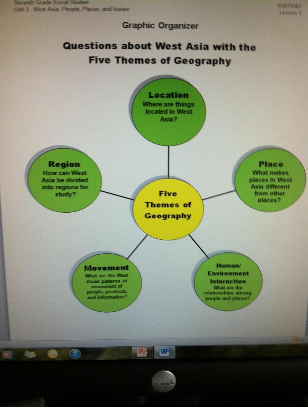
2 GRAPHIC ORGANIZER
3 BIG IDEAS OF THE LESSON: 1. The five themes of geography include location, place, region, movement, and human/environment interaction. 2. The five themes of geography are a structure for studying the people, places, and cultures of the world. 3. Regions are a way to organize geographic information about the world 4. Regions can be based on physical, historical, or cultural characteristics. 5. The geography of a region can be studied from the global, interregional, regional and local scales. 6. West Asia is one region in this part of the world. 7. Human/environment interaction happens when people adapt to and change the environment when drought, earthquakes, flooding and other natural disasters occur.
4 Learning Targets: 1. I can describe the five themes of geography including location, place, region, movement, and human/environment interaction. 2. I can explain that the five themes of geography are a structure for studying the people, places, and cultures of the world. 3. I can explain that regions are a way to organize geographic information about the world 4. I can interpret that regions can be based on physical, historical, or cultural characteristics. 5. I can identify that the geography of a region can be studied from the global, interregional, regional and local scales. 6. I can predict that West Asia is one region in this part of the world. 7. I can relate that Human/environment interaction happens when people adapt to and change the environment when drought, earthquakes, flooding and other natural disasters occur.

5 VOCABULARY Exploring the Geography of West Asia
6 # 1 Review the concept of region as it applies to the study of geography: Regions are human ideas based on the area s common geographical characteristics. These characteristics include physical, historical, and cultural geography. The concept of region helps people to organize and make sense of the world.
7 # 1 Copy and distribute the three outline maps located in the Supplemental Materials (Unit 3, Lesson 1). The first is a world map, the second is of West Asia, and the third is a map of India. 1. Use your atlases and textbooks to list and draw on the maps at least three different ways that the area on the map could be divided into regions. 2. The regions do not have to include all of the area on each map. For example, you could draw in the mountainous regions of the world, or the coastal region of India. 3. Regions include time zones, language, continents, landforms, religions, climate, etc.
8 GLOBAL
9 Interregional and Regional
10 Regional and Local
11 # 2 Once you have completed the three regions on each map, share your ideas with a partner. At this time you can discuss other ideas and add a fourth region to each map. Volunteers will point to and trace various regions on a large wall map. Write at the top of the page: Global on the world map, Interregional and Regional on the map of West Asia, and Regional and Local on the map of India. Discuss the meaning of these terms and how they help us to better understand the extent and impact of events. Are there are any regions that you have on all three maps? Using Google Earth or Google Maps ( ) in the various views (satellite, terrain, maps), zoom in and out from a global view to India as a regional view DISCUSS: What changes can be identified when zooming in and out from a global to local scale?
12 # 3 Using the map of West Asia as a guide outline and label this region on their world maps with a new color. Have heard other names for this region? *Guide them to the term Middle East, asking how many have heard this name? East of what?
13 # 3 F.Y.I. In the 1800s European geographers used the terms Near East, Middle East, and Far East for lands farther and farther east of Western Europe. Middle East is the only one still widely used. No other term means quite the same thing. It is the region around the eastern Mediterranean and the Persian Gulf. Often it includes Egypt as well. West Asia is the region that YOU will be studying, but much of the information, especially current events, will be found under the old name for the region, the Middle East. The largest portion of Russia is located in Asia. You will not be studying Russia in this unit or the next one on East Asia. Russia is covered in Units 5 and 6 of the sixth grade curriculum.
14
15 # 4 Using a copy of the Graphic Organizer at the beginning of the Supplemental Materials (Unit 3, Lesson 1), conduct a quick review of the five themes of geography. These include: Location -- A location can be absolute (for example, it can be stated as coordinates of longitude and latitude or as a distance from another place) or relative (estimated by comparison) it's northeast of here).
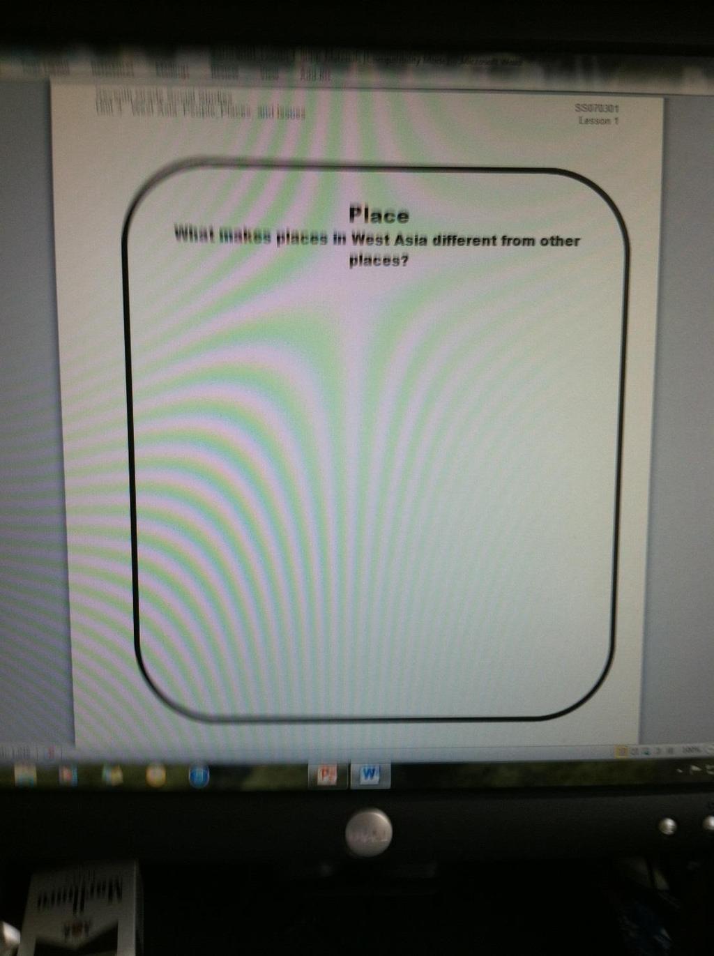
16 Place Differences in places might be defined in terms of climate, physical features, or the people who live there and their traditions. Human-Environment Interaction The positive and negative effects that occur when humans interact with their surroundings.
17 # 4 Movement -- A study of movement includes learning about major modes of transportation used by people, an area's major exports and imports, and ways in which people communicate (move ideas). Regions Regions are defined by the unifying characteristics including area, language, political divisions, religions, and vegetation (examples: French, dictatorship, Hindu, rainforest).
18 # 4 5 Themes of Geography Location -- A location can be absolute (for example, it can be stated as coordinates of longitude and latitude or as a distance from another place) or relative (estimated by comparison) it's northeast of here). Place Differences in places might be defined in terms of climate, physical features, or the people who live there and their traditions. Human-environment interaction The positive and negative effects that occur when humans interact with their surroundings. Movement -- A study of movement includes learning about major modes of transportation used by people, an area's major exports and imports, and ways in which people communicate (move ideas). Regions Regions are defined by the unifying characteristics including area, language, political divisions, religions, and vegetation (examples: French, dictatorship, Hindu, rainforest).
19 # 5 Copy the five pages of the Five Themes of Geography located in the Supplemental Materials (Unit 3, Lesson 1). Tape these to the board or glue them to five sheets of construction paper and place them on the wall or bulletin board. Check that the students are clear on the differences between the themes and how we use them to organize geographic information.
20
21
22
23
24
25 # 6 Copy the page Five Themes of Geography Activity sheet located in the Supplemental Materials (Unit 3, Lesson 1) - and cut apart the countries of Asia, - putting one for each student in an envelope or box. - Do the same with the Five Themes section. 1. Have the students draw out slips, one with a country name and one with a theme. 2. Give each student one Post-it note and have them glue the country name and the theme on the Post-it note. 3. Allow the students about ten minutes to research their country and theme to find an example that typifies that theme of geography. 4. Students write the information on the Post-it note and think about how they can answer the question under the theme on the poster. For example, if a student draws the country of Bangladesh and the theme of Human/Environment Interaction, they might write flooding on their Post-it and research how the heavily populated region that floods is built over the flood plain at the mouths of four rivers, emptying out into the Bay of Bengal. The land is fertile and thus good for agriculture, so the people continue to farm there.
26
27 # 7 The students place their Post-it notes on the appropriate larger theme page that has been put on the board or wall in step 5. As they do so they tell what they found out from their research about this country and its theme. Other students may also contribute by helping to answer the question that is under the theme on the large sheet. Leave the posters in place for later reference.
28 # 8 As a quick review activity, copy two sets of the pages for the I Have Who Has? game located in the Supplemental Materials (Unit 3, Lesson 1). Cut one set into strips and save another set as your answer key. Keep the first strip for yourself to start (and end) the game. Distribute the slips to the students. Give out all of the strips in any order. Have students team up if there are not enough or give some students extras depending on class size. All strips need to be used for this chain of answers to be complete. Students may use books and maps during the game. Begin the game by asking the question on your slip of paper. The student with the answer will respond by saying, I have The student then reads their question, starting with Who has?. This continues until the last question is asked for which you will have the answer. It is fun to time the class and see how quickly they can complete the answers. Then collect the slips and pass them out again for a review, timing the class responses again. Students may want to make up questions and answers to create their own version of this game.
29 I have Who has? game Cut the strips apart and distribute one to each student. Keep one for yourself. To start the game, read the question on your paper, Who has? Whoever has the correct answer responds and then reads their question. This continues until all the questions have been read. (Notes: The answers follow the questions on the next slip, so keep an uncut copy as an answer key to check the students answers. Suggest to the students that they research the I have part of their slip to be ready to answer their question.) I have monotheism. Who has an island country off the southeast coast of India? I have Sri Lanka. Who has the two longest rivers in India? I have the Brahmaputra River and the Indus River. Who has the famous mosque in Istanbul Turkey? I have the Hagia Sophia. Who has the capital of Syria, one of the oldest continuously inhabited cities? I have Damascus. Who has the country with the Tigris and Euphrates Rivers? I have Iraq. Who has the country where nearly 90% of the people are Shia Muslims?
30 I have Iran. Who has a landlocked country east of Iran? I have Afghanistan. Who has the Uzbekistan s major cash crop? I have cotton. Who has the country with Mt. Everest, the mountain in the world? I have Nepal. Who has the sea south of Iran and Pakistan? I have I have the Arabian Sea. Who has the seasonal winds of India and South Asia? I have monsoons. Who has the beautiful tomb built for a beloved wife in Agra, India? I have the Taj Mahal. Who has the word for a large landmass that is part of a continent? India is often called this. I have subcontinent. Who has the name for a local marketplace in Southwest Asia? I have bazaar. Who has an Islamic house of worship?
31 I have a mosque. Who has a storm with high winds and heavy rains? I have a cyclone. Who has a nomadic desert people of Southwest Asia who follow a traditional way of life? I have Bedouin. Who has a farm product grown for export? I have cash crop. Who has the term for a country that has limited industry, where agriculture is important and incomes are generally low? I have developing country. Who has the large inland sea that was drying up due to irrigation in the 1960s? I have the Aral Sea. Who has the rich mineral deposits in Kazakhstan that are used to make fertilizers? I have phosphates. Who has the largest lake north of Ian in West Asia that is called a sea? I have the Caspian Sea. Who has the lowest point in this region, at 1,312 feet below sea level located in Israel and Jordan? I have the Dead Sea. Who has the energy resource that has made many countries in this region rich?
32 I have petroleum. Who has the city often called the Old City that has important holy sites of Jews, Christians, and Muslims? I have Jerusalem. Who has the capital city that is located in both Asia and Europe? It was once called Constantinople. I have Istanbul. Who has the narrow gap between mountains in the Hindu Kush mountain range? I have the Khyber Pass. Who has the practice that has reduced the number of sturgeon in the Caspian Sea? I have poaching. Who has the ancient name of Iraq? I have Mesopotamia. Who has the name for the form of religion that means belief in one God? Judaism, Christianity, and Islam are all this type of religion.
33 # 8 THE GAME: Keep the first strip for yourself to start (and end) the game. Distribute the slips to the students. Give out all of the strips in any order. Have students team up if there are not enough or give some students extras depending on class size. All strips need to be used for this chain of answers to be complete. Students may use books and maps during the game. Begin the game by asking the question on your slip of paper. The student with the answer will respond by saying, I have The student then reads their question, starting with Who has?. This continues until the last question is asked for which you will have the answer. It is fun to time the class and see how quickly they can complete the answers. COLLECT THE STRIPS
34 # 9 The lesson ends with a focus on the theme of Human/Environment Interaction. Ask the students to suggest any natural disasters that were mentioned in the two previous activities. They can include something that might cause a natural disaster such as the monsoon or a cyclone which are part of the matching game in the previous step. Using the Internet, textbooks, and other research material, have students search for pictures that show how people change and adapt to the environment in such situations. For example, when an earthquake hit Pakistan people had to adapt to the destruction of their homes by living in tents or moving to other locations. Wrap up the lesson by making connections to the other themes of geography.
35 Assessment The students demonstrate their understanding of the five themes of geography and the concept of geographical scales (from global, interregional, regional and local) by citing examples and discussing how they help us better organize and understand geographic information.
36
37
38
39
40
Chapter 21 Southwest Asia: Harsh & Arid Lands
 Name Hour Chapter 21 Southwest Asia: Harsh & Arid Lands Essential Question: How has the physical geography of Asia influenced the development of these regions (i.e. history, population distribution, &
Unit 1 -Lesson 5. Population Patterns of the Eastern Hemisphere
 Unit 1 -Lesson 5 Population Patterns of the Eastern Hemisphere Population Patterns of the Eastern Hemisphere Population Patterns of the Eastern Hemisphere Big Ideas of the Lesson Population distribution
HUDSONVILLE MIDDLE SCHOOL COURSE FRAMEWORK
 HUDSONVILLE MIDDLE SCHOOL COURSE FRAMEWORK COURSE/SUBJECT 6 th Grade Social Studies UNIT PACING Unit 1 ~ Foundations of Social Studies September - October (6 weeks) explain that historians organize time
The Impact of Geography in South and East Asia
 The Impact of Geography in South and East Asia Gobi desert, Mongolia Essential Question: How does geography impact the distribution of population throughout South and East Asia? I CAN Explain how geography
South, Southeast, and East Asia. Physical Geography
 South, Southeast, and East Asia Physical Geography Mountains v Mountains are important in Asia because they influence: A. Population patterns B. Movement of people and goods C. Climate Mountains v The
The Impact of Geography in South and East Asia
 The Impact of Geography in South and East Asia Gobi desert, Mongolia Essential Question: How does the geography of SE Asia impact trade and the distribution of population throughout the region? (AKS #52a)
About places and/or important events Landmarks Maps How the land is, hills or flat or mountain range Connected to maps World Different countries
 What do you think you know about geography? About places and/or important events Landmarks Maps How the land is, hills or flat or mountain range Connected to maps World Different countries What do you
LEARNING OUTCOMES SST (G1-G12)
") LEARNING OUTCOMES SST (G1-G12) Grade 1 Learning Outcomes Students will be expected to: - demonstrate an understanding of the importance of interactions between people - demonstrate an understanding of
LEARNING OUTCOMES SST (G1-G12) Grade 1 Learning Outcomes Students will be expected to: - demonstrate an understanding of the importance of interactions between people - demonstrate an understanding of
The Impact of Geography in South and East Asia
 The Impact of Geography in South and East Asia Gobi desert, Mongolia Essential Question: How does the geography of SE Asia impact trade and the distribution of population throughout the region? (AKS #52a)
September 14, 2013 Objective: How does geography impact history? What important features exist that have shaped societies?
 Lowenhaupt 1 September 14, 2013 Objective: How does geography impact history? What important features exist that have shaped societies? Warm-Up: In your binder, answer the following question: Imagine you
Social Studies: The World Post Test Study Guide
 Name: Period: Social Studies: The World Post Test Study Guide Map and Globe Skills: Label the continents and oceans on the lines below the map. 1 11 3 4 5 8 2 9 10 8 6 7 1. 8. 2. 9. 3. 10. 4. 11. 5. 6.
Northwestern Consolidated Schools of Shelby County. Curriculum. World Studies (Eastern Hemisphere) Prepared by. Rich Ballard
 Prepared by. Rich Ballard") Northwestern Consolidated Schools of Shelby County Curriculum World Studies (Eastern Hemisphere) 7th Grade Prepared by Rich Ballard 2012-2013 1 Triton Central Middle School Vision Statement We are committed
Northwestern Consolidated Schools of Shelby County Curriculum World Studies (Eastern Hemisphere) 7th Grade Prepared by Rich Ballard 2012-2013 1 Triton Central Middle School Vision Statement We are committed
Name three countries in Europe.
 Name three countries in Europe. I will be able to identify the 5 themes of geography for Europe and locate the countries and capitals of Europe and the major physical features. People: Past: Through the
How Long Does it Take to Complete the Lapbook? SAMPLE PAGE
 Keep in mind that children of the same age can have very different academic and motor skills. Some children may have trouble writing in some of the smaller spaces of this lapbook. If this describes your
... Asia. Based on Bloom s Taxonomy. Human & Movement. Location Place. Regions. Environment. Interactions
 ... Asia Location Place Human & Environment Interactions Movement Regions LEVEL 1 Knowledge Match Show or Label List Information Recall Details (5Ws + H) Find Information LEVEL 2 Comprehension LEVEL 3
SOCIAL STUDIES GRADE 6. I Can Checklist REGIONS AND PEOPLE OF THE EASTERN HEMISPHERE. Office of Teaching and Learning Curriculum Division
 SOCIAL STUDIES REGIONS AND PEOPLE OF THE EASTERN HEMISPHERE GRADE 6 I Can Checklist 2018-2019 Aligned with Ohio s Learning Standards for Social Studies Office of Teaching and Learning Curriculum Division
By Geri Flanary To accompany AP Human Geography: A Study Guide 3 rd edition By Ethel Wood
 Session 1 By Geri Flanary To accompany AP Human Geography: A Study Guide 3 rd edition By Ethel Wood WHAT IS DEMOGRAPHY? It is the scientific or statistical study of population. It comes from the Greek
Grade 7 Social Studies
 Standard 1: History Students will examine the major movements, events, and figures that contributed to the development of nations in modern Africa, Asia, and the Southwest Pacific from acient civilizations
A Correlation of. Eastern Hemisphere. Ohio s Learning Standards Social Studies: K-12 Grade 6
 A Correlation of Eastern Hemisphere To Grade 6 to,, Grade 6 Introduction This document demonstrates how, Eastern Hemisphere, Ohio Edition, meets : K-12 Social Studies for Grade 6. Correlation page references
The study of Geography and the use of geographic tools help us view the world in new ways.
 S How does Geography help us understand our world? What factors shape the Earth s different environments? 7.1.9 7.2.9 BIG IDEAS COMPETENCIES Text pages or The study of Geography and the use of geographic
Prentice Hall. World Explorer: People, Places, Cultures Grade 7. Oklahoma Priority Academic Student Skills (PASS) for Grade 7 World Geography
 for Grade 7 World Geography") Prentice Hall World Explorer: People, Places, Cultures 2007 Grade 7 C O R R E L A T E D T O for Grade 7 1. Locate, gather, analyze, and apply information from primary and secondary sources. WORLD GEOGRAPHY
Prentice Hall World Explorer: People, Places, Cultures 2007 Grade 7 C O R R E L A T E D T O for Grade 7 1. Locate, gather, analyze, and apply information from primary and secondary sources. WORLD GEOGRAPHY
Reasoning with Physical Geography
 Activity APPLY For Teachers Reasoning with Physical Geography Where is Jerusalem located, and how might physical geography affect its location? For the complete activity with media resources, visit: DIRECTIONS
The Indian Ocean. Copyright 2010 LessonSnips
 The Indian Ocean One of the five major geographic divisions of the world s ocean, the Indian Ocean is located in the Eastern Hemisphere. The Indian Ocean is bounded by three continents: Africa to the west,
We are learning to describe how geography affected the growth of Mesopotamia.
 Name Team/Rotation Middle East, Past and Present Learning Targets and Success Criteria We are learning to describe how geography affected the growth of Mesopotamia. We are looking for the reasons why rivers
Critical Thinking. about GEOGRAPHY. The Middle East. Jayne Freeman
 Critical Thinking about GEOGRAPHY The Middle East Jayne Freeman WALCH EDUCATION The classroom teacher may reproduce materials in this book for classroom use only. The reproduction of any part for an entire
Sec$on 1: Geography and Early China. How does China s geography affect the culture?
 Sec$on 1: Geography and Early China How does China s geography affect the culture? Con$nents of the World Label the continents. Where is China located? Where is China located? In your groups, begin filling
1. Match the words in the first column to the meaning in the second column. [5]
![1. Match the words in the first column to the meaning in the second column. [5]](/thumbs/96/126839765.jpg "1. Match the words in the first column to the meaning in the second column. [5]") Exercise 1: [40 POINTS] 1. Match the words in the first column to the meaning in the second column. [5] Equator Around earth between the Equator and the Poles. Greenwich meridian Half of earth. Longitude
Exercise 1: [40 POINTS] 1. Match the words in the first column to the meaning in the second column. [5] Equator Around earth between the Equator and the Poles. Greenwich meridian Half of earth. Longitude
Peoples, Places and Cultures in Africa, Asia and the Southwest Pacific
 GRADE 7 Peoples, Places and Cultures in Africa, Asia and the Southwest Pacific Course 0470-07 Students in seventh grade explore the history, geography, government, economic systems, current issues, and
name and locate the world s seven continents and five oceans
 Subject: Geography Activities National Curriculum Objectives One Progression of Skills Name the 7 continents and 5 oceans 3D Jigsaw task to locate continents and seas name and locate the world s seven
2 Georgia: Its Heritage and Its Promise
 TERMS region, erosion, fault, elevation, Fall Line, aquifer, marsh, climate, weather, precipitation, drought, tornado, hurricane, wetland, estuary, barrier island, swamp PLACES Appalachian Mountains, Appalachian
Eastern Hemisphere Geography 7th Grade *Chapters 1-10 covered in 6 th Grade
 Quarter 1 Geography Tools and Concepts Chapters 1-5 Intro to Geography = 2 day review Goal Objective Task Analysis Vocabulary Text Location Goal 2.1: Analyze the 6-9.GEH.2.1.1 Explain and use the Identify
Ancient India UNIT 3 GEOGRAPHY CHALLENGE A L A. 1 Unit 3 Geography Challenge. Teachers Curriculum Institute miles
 UNIT 3 GEOGRPHY CHLLENGE ncient India HINDU KUSH HINDU KUSH H I M Desert Thar L Y N W E S 0 250 500 miles 0 250 500 kilometers Lambert zimuthal Equal-rea Projection 1 Unit 3 Geography Challenge UNIT 3
What is the name of the continent that is labeled #1 on the map?
 What is the name of the continent that is labeled #1 on the map? North America What is the name of the continent that is labeled #2 on the map? South America What is the name of the continent that is labeled
Lesson Graphic Organizer
 Lesson Graphic Organizer Theme Location Where is it? Questions What is its absolute location? What is its relative location? Place What is it like there? What are its natural characteristics? What are
Unit 1: Basics of Geography Test Review
 Name Date Period Unit 1: Basics of Geography Test Review Directions: Reading the following sections and complete the questions, charts, and diagrams. Types of Maps Maps that have a particular theme are
Early College High School PreAP World Geography Summer Reading Assignment
 Early College High School PreAP World Geography Summer Reading Assignment In preparation for your studies in World Geography you will be familiarizing yourself with the 5 Themes of Geography. This assignment
HPISD CURRICULUM (SOCIAL STUDIES, GRADE 6)
") HPISD CURRICULUM (SOCIAL STUDIES, GRADE 6) EST. NUMBER OF DAYS: 6A 10 DAYS, 6B 15 DAYS UNIT NAME Unit Overview Generalizations/Enduring Understandings TOPIC 6A: NORTH AFRICA TOPIC 6B: SOUTHWEST ASIA A-B:
HPISD CURRICULUM (SOCIAL STUDIES, GRADE 6) EST. NUMBER OF DAYS: 6A 10 DAYS, 6B 15 DAYS UNIT NAME Unit Overview Generalizations/Enduring Understandings TOPIC 6A: NORTH AFRICA TOPIC 6B: SOUTHWEST ASIA A-B:
GRADE 6 GEOGRAPHY TERM 1 LATITUDE AND LONGITUDE (degrees)
") 1 GRADE 6 GEOGRAPHY TERM 1 LATITUDE AND LONGITUDE (degrees) Contents Lines of Latitude... 2 Lines of Longitude... 3 The hemispheres of The Earth... 4 Finding countries and cities on a map using latitude
1 GRADE 6 GEOGRAPHY TERM 1 LATITUDE AND LONGITUDE (degrees) Contents Lines of Latitude... 2 Lines of Longitude... 3 The hemispheres of The Earth... 4 Finding countries and cities on a map using latitude
Item Specifications Summary 7 th grade World Geography Assessment
 Item Specifications Summary 7 th grade World Geography Assessment 2013-14 Structure: 65 multiple choice questions (15 field test items) Minimum of 6 questions per standard At least 75% of objectives have
MR. JOHNSON S. Geography OHIO COUNTY MIDDLE SCHOOL
 MR. JOHNSON S Geography OHIO COUNTY MIDDLE SCHOOL CHAPTER 1 Geography The science of geography is likely the oldest of all sciences. Geography is the answer to the question that the earliest humans asked,
World Geography Unit Curriculum Document
 Unit Number and Title: Unit 5-Southwest Asia/North Africa (Egypt, Libya, Iraq, Afghanistan, Israel, Saudi Arabia, Iran) Curriculum Concepts: Religious conflict Oil Water Enduring Understandings (Big Ideas):
Year 34 B2 Geography - Continents and Oceans 2018 Key Skills to be covered: Taken from Level 3 Taken from Level 4
 Key Skills to be covered: Taken from Level 3 Taken from Level 4 Geographical Enquiry: I ask, Which PHYSICAL features does this place have? I ask, Which HUMAN features does this place have? I give reasons
Grade 6 Social Studies
 Unit Title: Africa : Movement Location Place Human Region : Subject/Course: 6 th Grade Social Studies Essential Questions: peoples, cultures and ideas of the world? How is a location identified using map
8th Geography Pre-Test
 Quiz Preview Go back Student's Name appears here Course Name appears here QuizStar 8th Geography Pre-Test Quiz Directions Choose the BEST answer for each question. Directions: 1. Answer the questions below
DC Educational Standards Science Grade: 6 - Adopted: Matter and Its Interactions
 Main Criteria: DC Educational Standards Secondary Criteria: Subjects: Science, Social Studies Grade: 6 Correlation Options: Show Correlated ESSENTIAL DC.MS-PS. MS-PS1. DC Educational Standards Science
UNIT 11 SOUTH ASIA SG 1 - PHYSICAL GEOGRAPHY & THE ENVIRONMENT
 UNIT 11 SOUTH ASIA SG 1 - PHYSICAL GEOGRAPHY & THE ENVIRONMENT I. PHYSICAL GEOGRAPHY TAKE OUT YOUR PHYSICAL MAP OF SOUTH ASIA A. The Himalayan Mountains form the northern boundary of the region (color
Witchampton CofE First School Geography Curriculum Map
 2016-2017 Autumn People and : 30-50 Show interest in the lives of people who are familiar to them. Shows interest in different occupations. Remembers and talks significant events in their own experience.
1 st Term Test 2014 Maris Stella College - Negombo. Geography
 Grade 9 1 st Term Test 2014 Maris Stella College - Negombo Geography 2 Hour Name(. Class ( No ( Use MCQ paper to answer Part 1. 1) What is the Blue Planet? i. Neptune iii. Uranus ii. Earth iv. Merury 2)
21st Century Global Learning
 21st Century Global Learning A focus for 7th grade is on the ever-increasing global interactions in society. This focus includes a study of various societies and regions from every continent. We have already
OUR COUNTRY INDIA LOCATIONAL SETTING
 7 India is a country of vast geographical expanse. In the north, it is bound by the lofty Himalayas. The Arabian Sea in the west, the Bay of Bengal in the east and the Indian Ocean in the south, wash the
World Geography. Teacher s Guide
 World Geography Teacher s Guide WALCH PUBLISHING Table of Contents To the Teacher.......................................................... vi Classroom Management.................................................
Many Ways to Name a Place
 Your web browser (Safari 7) is out of date. For more security, comfort and Activityapply the best experience on this site: Update your browser Ignore Many Ways to Name a Place What are the names for the
a. Hunting and gathering SE/TE: 17, 19, 21, 22, 23, 25, 30 b. Tool making SE/TE: 17, 18, 19, 22, 23 c. Use of fire SE/TE: 17, 23, 30
 Ohio Academic Content Standards, Social Studies, Benchmarks and Indicators (Grade 6) Grade Six History Students use materials drawn from the diversity of human experience to analyze and interpret significant
Module 7, Lesson 1 Water world
 Module 7, Lesson 1 Water world Imagine that the year is 2100. Scientists have determined that the rapidly warming climate of the earth will cause the ice sheets of Antarctica to break apart and melt at
Why Geography Matters
 Why Geography Matters Vocabulary words geography relative location absolute location physical feature human feature region modify adapt cause effect geography: The study of the Earth s physical and human
GRADE LEVEL EXPECTATIONS CORRELATION NOTATIONS
 Book Title: World Studies: The Eastern Hemisphere 2005 Grade Level: 6 Publisher: Pearson Prentice Hall Subject/Course: Social Studies, Grade 6 Geography The World in Spatial Terms Grade 6 1. Use latitude
Geography and World Cultures
 Core Geography and World Cultures Geography and World Cultures offers a tightly focused and scaffolded curriculum that enables students to explore how geographic features, human relationships, political
What on Earth is Geography? Using the Five Themes of Geography to Study the Continent of Asia.
 What on Earth is Geography? Using the Five Themes of Geography to Study the Continent of Asia. Name Date Essential questions: 1. How can we study the geography of our Earth? a. What are the five themes
relationships between physical environments an society
 Lesson Plans Geography Grade 9 Mrs. Newgard Monday, December 7 o Objective: Find out what has affected the modern development of the Arabian Peninsula. Go over Arabian Peninsula map together Notes 18.4
Grade Level Expectations for the Sunshine State Standards
 for the Sunshine State Standards FLORIDA DEPARTMENT OF EDUCATION http://www.myfloridaeducation.com/ The sixth grade student: Time, Continuity, and Change [History] understands that historical events are
LET S GO ON A ROAD TRIP
 Partner School News June 2016 In this issue: Education Children Around the World www.opportunityeducation.org Road Trip Start Writing Right Now Teaching Tip of the Month Focus on Schools LET S GO ON A
Book Title: World Studies, Medieval Times to Today 2005 Grade Level: 6 Publisher: Pearson Prentice Hall Subject/Course: Social Studies, Grade 6
 Book Title: World Studies, 2005 Grade Level: 6 Publisher: Pearson Prentice Hall Subject/Course: Social Studies, Grade 6 Geography The World in Spatial Terms Grade 6 1. Use latitude and longitude to determine
Chapter 1 Study Guide
 Chapter 1 Study Guide Reminders: Vocabulary quiz and test will be on Tuesday, September 6th. Complete study guide and bring completed to school Friday, September 2nd. You are NOT required to print the
Barlows Primary School Geography Curriculum Content Key Stage 1 and
 Geography Curriculum Content Key Stage 1 and 2 2017-2018 Curriculum Content Year 1 The content for Year 1 is detailed below: WHAT ARE SEASONS? WHAT SIT LIKE WHERE WE LIVE? WHERE DO DIFFERENT ANIMALS LIVE?
Geography Route Planner
 Geography Route Planner Introduction to Route Planners Route Planners outline the Key Stages 1-3 curriculum to be taught within each campus of the Bury St Edmunds Trust. Each Route Planner has been designed
Chapter 2 - Lessons 1 & 2 Studying Geography, Economics
 Chapter 2 - Lessons 1 & 2 Studying Geography, Economics How does geography influence the way people live? Why do people trade? Why do people form governments? Lesson 1 - How Does Geography Influence the
Centerville Jr. High School Curriculum Mapping (7 th Grade Geography) (Mike Day)
 (Mike Day)") Centerville Jr. High School Curriculum Mapping (7 th Grade Geography) (Mike Day) Standard 1 History Students examine the major movements, events and figures that contributed to the development of Africa,
Centerville Jr. High School Curriculum Mapping (7 th Grade Geography) (Mike Day) Standard 1 History Students examine the major movements, events and figures that contributed to the development of Africa,
HISTORY & GEOGRAPHY 702 (NEW EDITION)
") Geography CONTENTS Introduction.......................................................... 2 Curriculum Outline.................................................... 3 HISTORY & GEOGRAPHY 702 (NEW EDITION)
Geography CONTENTS Introduction.......................................................... 2 Curriculum Outline.................................................... 3 HISTORY & GEOGRAPHY 702 (NEW EDITION)
Chapter 27. Bhutan, Maldives, Nepal, & Sri Lanka
 Chapter 27 Bhutan, Maldives, Nepal, & Sri Lanka Physical Geography of Bhutan, Maldives, Nepal & Sri Lanka Landforms Their locations on the fringe of South Asia means their physical and human geography
Warm up: (8 min) Use the Map, On the Prom (Color) Paper (Blk/White) and answer the questions on your paper
 Use the Map, On the Prom (Color) Paper (Blk/White) and answer the questions on your paper") Warm up: (8 min) Use the Map, On the Prom (Color) Paper (Blk/White) and answer the questions on your paper TX History: Mapping and Geography of Texas: We will discuss some slides and write notes on others
Warm up: (8 min) Use the Map, On the Prom (Color) Paper (Blk/White) and answer the questions on your paper TX History: Mapping and Geography of Texas: We will discuss some slides and write notes on others
Five Themes of Geography of Ecuador
 LESSON 1 Five Themes of Geography of Ecuador Lesson Objective The students will be able to: find the five themes of geography (location, movement, human/environment interaction, place, and region) of Ecuador
Book Title: History of Our World, The Early Ages Edition 2005 Grade Level: 6 Publisher: Pearson Prentice Hall Subject/Course: World History, Grade 6
 Book Title: History of Our World, The Early Ages Edition 2005 Grade Level: 6 Publisher: Pearson Prentice Hall Subject/Course: World History, Grade 6 Geography The World in Spatial Terms Grade 6 1. Use
34 A SPRING 1 GEOGRAPHY
 Year ¾ Key Skills to be covered, taken from National Curriculum pitching at the correct year group and differentiation within plan for different groups Be specific in the key skills, and make them more
Essential Questions What are the major physical components of the world, and how are they represented on a map? 3.4
 Third Grade Social Studies Unit One Six Weeks GEOGRAPHY Originally compiled by Russellville In order for students to understand that geography influences the development of a region as well as the interactions
Module 7, Lesson 1 Water world
 Module 7, Lesson 1 Water world Imagine that the year is 2100. Scientists have determined that the rapidly warming climate of the earth will cause the ice sheets of Antarctica to break apart and melt at
Prentice Hall World Studies, Asia and the Pacific 2005 Correlated to: Missouri Social Studies Grade Level Expectations (Grade 7)
") Principles of Constitutional Democracy 1. Knowledge of the principles expressed in documents shaping constitutional democracy in the United States Concepts A. (1) Principles expressed in documents shaping
Principles of Constitutional Democracy 1. Knowledge of the principles expressed in documents shaping constitutional democracy in the United States Concepts A. (1) Principles expressed in documents shaping
THIS DOCUMENTS IS 17 PAGES LONG
 06.01 Geography of Europe Properties Title: Type: Subject: Grade Range: Description: Duration: Author(s): 06.01 Geography of Europe Instructional Unit Social Studies - GPS (K-12) 6 th Grade Unit 1, Sixth
Ohio s State Tests ANSWER KEY & SCORING GUIDELINES GRADE 6 SOCIAL STUDIES PART 1
 Ohio s State Tests ANSWER KEY & SCORING GUIDELINES GRADE 6 SOCIAL STUDIES PART 1 Table of Contents Questions 1 4: Content Summary and Answer Key...1 Question 1: Question and Scoring Guidelines...3 Question
SOCIAL STUDIES Grade 6 Standard: History
 Standard: History Chronology A. Interpret relationships between events shown on multipletier 1. Construct a multiple-tier time line from a list of events time lines. and interpret the relationships between
Iceland. 1. Warm up. A. Talk about the picture and read the essay. B. Discuss the questions about the essay.
 1. Warm up A. Talk about the picture and read the essay. Iceland My country, Iceland, is one of the most beautiful countries on Earth. It is an island country. It is located in Europe, in the North Atlantic
CHAPTER 1. Geo Challenges 1A to 1D. & World Map Activity
 CHAPTER 1 Geo Challenges 1A to 1D & World Map Activity SELECT YOUR CHALLENGE World Map Activity Challenge 1A Challenge 1B Challenge 1C Challenge 1D Challenge 1A WS PG. 2 STEP #1 Label the largest continent
Nursery. Reception. Year 1
 Nursery Geography Overview Autumn Spring Summer Notices detailed features of objects in their environment. Comments and asks questions about aspects of their familiar world such as the place where they
Learning Target : Describe the purposes and uses of different types of maps.
 Learning Target : Describe the purposes and uses of different types of maps. Directions: 1. Below, place a where you think you are located. 2. In which continent are you located? 3. In which country are
Geography Skills Progression. Eden Park Primary School Academy
 Geography Skills Progression Eden Park Primary School Academy In order to ensure broad and balanced coverage, we follow these principles: Within each phase, geography is a driver for at least 3 Learning
Unit 1: Geography. For additional information, refer to this website: 1 G e o g r a p h y
 Unit 1: Geography For additional information, refer to this website: http://mryoungtms.weebly.com/ 1 G e o g r a p h y Continents and Oceans SOL USI. 2a Essential Understanding: Continents are large land
Physical Geography of the United States and Canada Chapter 5 A Land of Contrasts
 Physical Geography of the United States and Canada Chapter 5 A Land of Contrasts Land Area Together the U.S. and Canada cover more than 7 million square miles. In total area, Canada ranks 2 nd and the
4th Grade US Regional Geography First Nine Weeks
 4th Grade US Regional Geography First Nine Weeks 2014-2015 Identify the choice that best completes the statement or answers the question. 1 The line identified as 0 runs west and east on the globe and
locate the world s countries, using maps to focus on Europe (including the location of
 Year 3 and 4 Geography study- Autumn 2 2017 National curriculum: Locational knowledge locate the world s countries, using maps to focus on Europe (including the location of Russia) and North and South
Wayne E. Sirmon GEO 301 World Regional Geography
 Wayne E. Sirmon GEO 301 Geography 301 Geography 301 MAP: A graphic representation of a portion of the earth s surface dawn to scale, as seen from above. Types of Maps Climate maps give general information
New National Curriculum Geography Skills Planning KS1
 New National Curriculum Geography Skills Planning KS1 Enquiry Question Objective-essential knowledge skills or understanding Locational Knowledge Standards /Success Criteria Lesson progression over half
CHAPTER 1: EXPLORING GEOGRAPHY
 CHAPTER 1: EXPLORING GEOGRAPHY Please Do Now: In your PDN section of your binder answer the following with one or two sentences: What is Geography? What is Geography? The study of where people, places,
What Is a Globe? Hemispheres. Main Idea Globes and maps provide different ways of showing features of the earth. Terms to Know
 r Main Idea Globes and maps provide different ways of showing features of the earth. Terms to Know hemisphere latitude longitude scale bar scale relief elevation contour line What Is a Globe? A globe is
Introduction to Egypt
 Instructional Sequence/Procedure (Req.): 1. Assign appropriate reading of text and an introductory take- home quiz about Egypt in anticipation of day 1 of the lesson. The quiz will not be graded, but will
World Geography to ALL Students book (teacher book).
.") Sample Pages are from the What I Need to Know to Successfully Teach World Geography to ALL Students book (teacher book). This book contains the content in the student book, the reformatted Standards for
Sample Pages are from the What I Need to Know to Successfully Teach World Geography to ALL Students book (teacher book). This book contains the content in the student book, the reformatted Standards for
Name: Date: Period: #: Chapter 1: Outline Notes What Does a Historian Do?
 Name: Date: Period: #: Chapter 1: Outline Notes What Does a Historian Do? Lesson 1.1 What is History? I. Why Study History? A. History is the study of the of the past. History considers both the way things
7th Grade Social Studies Teaching and Learning Framework*
 7th Grade Social Studies Teaching and Learning Framework* Unit 1/Intro Unit 2 Unit 3 Unit 4 Unit 5 Connecting Themes & Enduring Understanding 10 Days What themes and big ideas do we see in 7 th grade SS?
Progression of skills in Geography
 New Curriculum Holy Trinity CE Primary Academy 2013-14 Subject: Geography Skills: Progression of skills in Geography Geographical enquiry Teacher led enquiries, to ask and respond to simple closed questions.
Geography Mile Post 1
 Mile Post 1 Use world maps, atlases and globes to identify the UK and its countries, as well as the countries, continents and oceans studied at this key stage Key Skills IPC learning Goals 1.11 Be able
Geography 7 Final Exam Review Guide (Eppler)- 2014
- 2014") Geography 7 Final Exam Review Guide (Eppler)- 2014 Name Hour EXAM SPECIFICS There are five types of questions on this exam 1. Multiple choice (41) 2. Maps (5) 3. Short reading passages (5) 4. Tables /
Geography 7 Final Exam Review Guide (Eppler)- 2014 Name Hour EXAM SPECIFICS There are five types of questions on this exam 1. Multiple choice (41) 2. Maps (5) 3. Short reading passages (5) 4. Tables /
Range of Opportunities
 Geograhy Curriculum Cropwell Bishop Primary School Range of Opportunities Year 1 Year 2 Year 3 Year 4 Year 5 Year 6 All Key Stage 1 Key Stage 2 Investigate the countries and capitals of the United Kingdom.