Dokdo/Takeshima: Who Owns It? Kelly Swanson
|
|
|
- Barnard Patrick
- 5 years ago
- Views:
Transcription

1 Dokdo/Takeshima: Who Owns It? Kelly Swanson Introduction: The vast majority of Americans, including our students, do not know where Dokdo/Takeshima Islands are located, nonetheless that they are hotly debated between Korea and Japan. The location of the islands, as well as the historical claims, are part of the solution to figuring out who owns the islands located in the East Sea/Sea of Japan. Both Korea and Japan claim ownership of the islands. In this activity, students will be evaluating 14 different historical maps, documents, and pictures to determine which country has a better claim to the islands. Students will need to write up their results and justify which claims hold more value in their minds. The teacher could use the map above to show the location of the islands. One of the artifacts that the students will be analyzing to figure out ownership of the islands in this activity will show a picture of Dokdo looking from the island of Uleungdo. It is important that a map either be given to the students at the beginning of the activity or this map (or similar map) be visible throughout the activity. The introduction to this activity should be brief and should only include the names of the islands and the location of the islands. Students should also receive the handout with the islands names and spelling in both Korean and Japanese.
2 Handout #1: 독도 / 獨島 Dokdo Solitary Island in Korean たけしま / 竹島 Takeshima Bamboo Island in Japanese

3 Give the students the following maps on the overhead/projector or print them off for them to look at and answer the three questions posed on the maps. Why would two different maps show the same islands written in two different ways? Both maps have been zoomed in to show the Dokdo/Takeshima islands. The original maps show the entire countries of South Korea and Japan respectively. Map #1 is Korean. The students will be able to use Handout #1 to determine the language and hence the sovereignty claims for this map. Map #2 is a Japanese map of the island of Takeshima.
4 This short exercise will give them the practice to determine where the islands are located on the artifacts occurring later in the activity. Since many of the primary documents that the students will be looking at in this activity will be in the host countries language it is important to have the spelling of the islands in their native language. Students should keep this sheet with them when performing the stations. Upon completion of the activity students will receive post-it notes. Color number one should be a sticky note of one color that represents which artifact had the most sway in their decision. Nothing needs to be written on it but a discussion can ensue as to why that particular artifact had the most influence on students. Why did some of the artifacts have no post-it notes attached to them, whereas some of the others have many? Google Earth can be used to show the location of the islands. Using other geospatial technologies would allow the students to interact with the maps to determine location of the islands and possibly ownership of the islands. Student may ask the question Why do these islands matter? This gets at the heart of sovereignty and natural resource allocation. Claims of minerals and natural resources located in the ocean give both countries claims to the rights to mine or drill for those resources in the ocean depths. This may mean millions of dollars for each country and a reduction in the dependence of foreign fuel sources especially for two countries with not a lot of natural resources to begin with. A description of UNCLOS (United Nations Conference on the Law Of the Sea) should ensue this description. Sovereignty rights in the ocean are a big issue for many countries in the world today. Objectives: Students will be able to determine sovereignty arguments regarding the Dokdo/Takeshima Islands by means of analyzing historical records, maps, and documents. National Content Standards in Geography: Standard 1 How to use maps and other geographic representations, tools, and technologies to acquire, process, and report information. Standard 3 How to analyze the spatial organization of people, places, and environments on Earth s surface. Standard 5 That people create regions to interpret Earth s complexity. Standard 6 How culture and experience influence people s perception of places and regions. Standard 13 How forces of cooperation and conflict among people influence the division and control of Earth s surface. Standard 17 How to apply geography to interpret the past.
5 State Geography Content Standards (Minnesota): Standard 1 People use geographic representations and geospatial technologies to acquire, process and report information within a spatial context. Benchmark Apply geographic information from a variety of print and electronic sources to interpret the past and present and plan for the future; provide rationale for using specific technologies for each application. Standard 2 Geographic inquire is a process in which people ask geographic questions and gather, organize and analyze information to solve problems and plan for the future. Benchmark Use geospatial technologies to develop plans for analyzing and solving local and regional problems that have spatial dimensions. Standard 3 Places have physical characteristics (such as climate, topography and vegetation) and human characteristics (such as culture, population, political and economic systems). Benchmark Make inferences and draw conclusions about the physical and human characteristics of places based on a comparison of maps and other geographic representations and geospatial technologies. Standard 8 Processes of cooperation and conflict among people influence the division and control of the earth s surface. Benchmark Define the concepts of nationalism and sovereign political states and explain how sovereignty is impacted by international agreements. Benchmark Analyze the impact of colonialism on the emergence of independent states and the tensions that arise when the boundaries of political units do not correspond to the nationalities or ethnicities of the people living within them. Basic Preparation: The teacher will print off the materials for the lesson provided in the lesson materials section. Each of the 14 artifacts should be set up as an individual station for students to analyze the particular document. Group size will vary depending upon the size of the class. Ideally, groups of 2-3 would be working at each station. Students will spend a minimum of one minute and a maximum of 2-3 minutes for each station depending upon the time frame for each class period. Stations should be set up with odd numbers representing Korean claims and even numbers representing Japan claims on the islands. This will mean that students will not have an original bias towards one particular side at the onset of the activity.
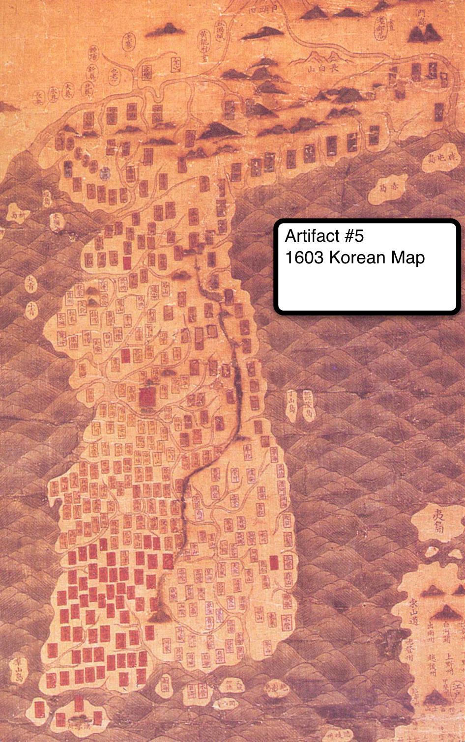
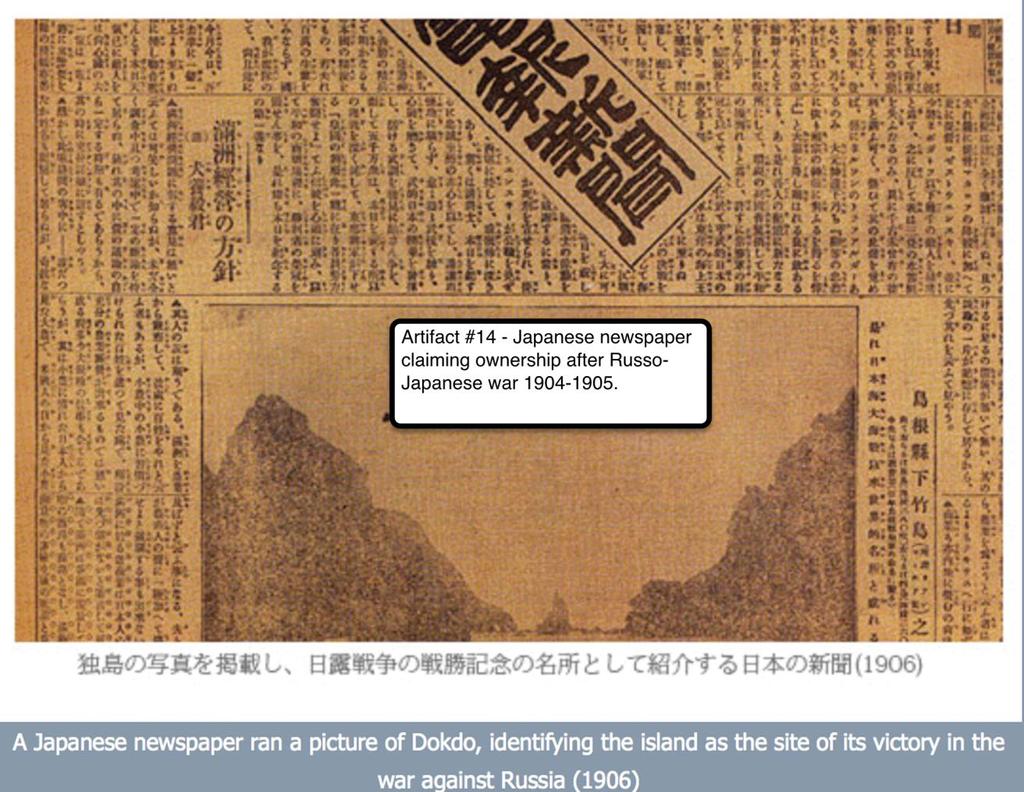
6 Materials Needed: 1. Printed copies of the 14 artifacts found in this lesson plan - Captions are provided on most artifacts to assist students in what they are looking at. 2. Post-it notes. The following are the artifacts that should be used at each station. There will be 14 stations. One artifact should be located on each station.
 included at the beginning of the Sinjeung Dongguk Yeoji Seungram (Revised and augmented version on the survey of the national")
7 Paldochongdo (Map of Korea) Korea, Lee Haeng, et al., 1531, 34.2x27.0 cm, Housed in the Seoul Museum of History Paldochongdo (Map of Korea) included at the beginning of the Sinjeung Dongguk Yeoji Seungram (Revised and augmented version on the survey of the national geography of Korea). This map contains the names of and brief information on major geographic features including mountains, rivers, islands, seas, and provinces. Both Ulleungdo and Dokdo are clearly seen in the East Sea in the map. However, the location of Dokdo is not accurate. Dokdo lies to the east of Ulleungdo. In fact, the actual location of Dokdo is to the southeast of Ulleungdo. The toponym East Sea is also first used in this Korea map.

8

9 This 1673 map of Korea shows Dokdo as a part of Korea in the East Sea/Sea of Japan. Can you find where it is located on the map?

10 This 1873 map of Japan shows Takeshima Island as a part of the Japanese state.
11

12

13

14

15 Joseon was the dynasty that ruled the Korean peninsula from 1392 until The dynasty was the longest ruling Confucian dynasty on record.

16

17 Dokdo is visible from Ulleungdo Island in the East Sea/Sea of Japan. Dokdo is 87.4 kilometers away from Ulleungdo and assessable via ship transport on calm ocean days bringing tourists from the mainland of Korea.

18

19 This 1808 document shows the Korean claim to sovereignty of the islands. Note that another name for Dokdo is Usando in the statement from the Mangi yoram. The Mangi yoram is a book on the Essentials of Goverance that dictated the financial affairs of the Korean state. This book wrote down the economic and military principles during the Joseon dynasty which ruled Korea from
20
21 Teaching the Lesson: When teaching the lesson students should be walking to each station and viewing the document/artifact on each station. They should write down one fact supporting the claim for each of the artifacts in the lesson. There are seven artifacts supporting Korea s claim and seven artifacts supporting Japan s claim on the islands. Opening the Lesson: Organize the class into groups as even as possible divided by 14. A class of 28 will have two students per station as they rotate around the classroom and analyze each artifact. Inform the students that they will have only 2-3 minutes per artifact to determine and find the islands claim by one of the two countries. Developing the Lesson: The teachers should print out each of the artifacts in the lesson for the stations. The teacher may want to add a section or artifacts demonstrating geospatial technologies and finding the islands on such sites as Google Earth. This could add a 15 th station to the activity. Make sure to have the students zoom back out upon completion of their station time if this method is invoked. Closing the Lesson: Upon conclusion of the 14 stations the students will write a one page summary explaining their position on the Dokdo/Takeshima islands dispute. They should have two arguments for their case and one refute against the other countries claims to the islands to receive full points. A rubric will be provided for teacher assistance in scoring the essay. The essay needs to be an argumentative paper, a key concept in the common core standards for social studies and geography. They should be advocating for one country over the other country. The following rubric created by Kelly Swanson from RubiStar could be used to score student papers.

22
Reading a Map in Any Language. Dawn Shattuck NICC; Kathy Sundstedt School not available. Content Area (Req.): Geography Unit (Opt.
: Geography Unit (Opt.") Instructional Sequence/Procedure (Req.): 1. Distribute one copy of Chile map, written in Spanish, to each student group OR direct each group of students to access an online copy of a Chile map. 2. Together,
Instructional Sequence/Procedure (Req.): 1. Distribute one copy of Chile map, written in Spanish, to each student group OR direct each group of students to access an online copy of a Chile map. 2. Together,
Delaware Recommended Curriculum Grade 7 Geography Standard 4b. Authors/Editors: Kristin Schlegel Maggie Legates
 Delaware Recommended Curriculum Grade 7 Geography Standard 4b Authors/Editors: Kristin Schlegel Maggie Legates THIS UNIT WAS ADAPTED FROM BEYOND BORDERS A UNIT FOR MIDDLE GRADES FROM This unit was originally
AP Human Geography Syllabus
 AP Human Geography Syllabus Textbook The Cultural Landscape: An Introduction to Human Geography. Rubenstein, James M. 10 th Edition. Upper Saddle River, N.J.: Prentice Hall 2010 Course Objectives This
Your web browser (Safari 7) is out of date. For more security, comfort and. the best experience on this site: Update your browser Ignore
 is out of date. For more security, comfort and. the best experience on this site: Update your browser Ignore") Your web browser (Safari 7) is out of date. For more security, comfort and lesson the best experience on this site: Update your browser Ignore Political Borders Why are the borders of countries located
Your web browser (Safari 7) is out of date. For more security, comfort and lesson the best experience on this site: Update your browser Ignore Political Borders Why are the borders of countries located
DESCRIPTION ACADEMIC STANDARDS INSTRUCTIONAL GOALS VOCABULARY. Subject Area: Geography
 DESCRIPTION Middle America is a cultural crossroads. African, Native American, and European influences are seen in its religions, foods, architecture, languages, and arts. Includes discussion of terrains
Ta b l e o f C o n t e n t s
 Ta b l e o f C o n t e n t s Introduction..................................................................3 How to Use This Book.........................................................4 Standards Information.........................................................6
Alleghany County Schools Curriculum Guide GRADE/COURSE: World Geography
 GRADE/COURSE: World 2013-14 GRADING PERIOD: 1 st Six Weeks Time Frame Unit/SOLs SOL # Strand Resource Assessment 8 days* The student will use maps, globes, satellite images, photographs, or diagrams to
E/CONF.105/115/CRP.115***
 E/CONF.105/115/CRP.115*** 30 June 2017 Original: English 11 th United Nations Conference on the Standardization of Geographical Names New York, 8-17 August 2017 Item 9a) of the provisional agenda* National
Looking at Communities: Comparing Urban and Rural Neighborhoods
 Looking at Communities: Comparing Urban and Rural Neighborhoods OVERVIEW & OBJECTIVES Our urban areas have become so dominant that frequently the children we teach have no connection with and very few
Why Do We Live Here? : A Historical Geographical Study of La Tabatiere, Quebec North Shore
 Why Do We Live Here? : A Historical Geographical Study of La Tabatiere, Quebec North Shore Lesson Overview Many communities and their occupants have historical connections to exploration routes and traditional
K- 5 Academic Standards in. Social Studies. June 2013
 K- 5 Academic s in Social Studies June 203 Word Tables of s ONLY This Word version of the 2.7.2 social studies standards (DRAFT for Rulemaking 2.7.2) document contains the standards ONLY; no explanatory
Critical Thinking. about. GeoGRAPHY. United States, Canada, and Greenland. Jayne Freeman
 Critical Thinking about GeoGRAPHY United States, Canada, and Greenland Jayne Freeman WALCH EDUCATION Contents Introduction............................................................... v National Geography
Reading a Map in Any Language. Kathy Sundstedt and Dawn Brown School not available. Content Area (Req.): Geography Unit (Opt.):
: Geography Unit (Opt.):") Instructional Sequence/Procedure (Req.): 1. Distribute one copy of Bangladesh map, written in Bengali, to each student group. 2. Optional project the same map on the wall from transparency, overhead projector,
Instructional Sequence/Procedure (Req.): 1. Distribute one copy of Bangladesh map, written in Bengali, to each student group. 2. Optional project the same map on the wall from transparency, overhead projector,
What on Earth is Geography? Using the Five Themes of Geography to Study the Continent of Asia.
 What on Earth is Geography? Using the Five Themes of Geography to Study the Continent of Asia. Name Date Essential questions: 1. How can we study the geography of our Earth? a. What are the five themes
Grade 5: Social Studies Practices
 Grade 5: Social Studies Practices A. Gathering and Using Evidence 1. Develop questions to help identify evidence about topics related to the historical events occurring in the Western Hemisphere that can
My Map Activity MINNESOTA SOCIAL STUDIES STANDARDS & BENCHMARKS
 My Map Activity OVERVIEW & OBJECTIVES Students will learn the basics of Google Maps while using geospatial data to create their neighborhood map with the places they spend time. They will also collect
Kindergarten 2011 Social Studies Strands & Standards STRAND SUBSTRAND STANDARD
 2011 Social Studies Strands & Standards STRAND SUBSTRAND STANDARD 0.1 Citizenship & Government 0.2 Economics 0.3 Geography 0.1.1 Civic Skills 0.1.2 Civic Values & Principles of Democracy 0.1.4 Governmental
Republic of Korea in Czech atlases and geography textbooks. Jan Ptacek, Kartografie Praha
 Republic of Korea in Czech atlases and geography textbooks Jan Ptacek, Kartografie Praha Schools in the Czech republic Primary schools 9 years (age 6 15) Geography from the age of 11, only one year of
K- 5 Academic Standards in. Social Studies. June 2013
 - 5 Academic s in Social Studies June 2013 Word Tables of s ONLY This Word version of the 2.17.12 social studies standards (DRAFT for Rulemaking 2.17.12) document contains the standards ONLY; no explanatory
Kindergarten: Foundations of Social Studies
 4. Governmental Institutions and Political Processes 1. Citizenship and Government 2. Civic Values and Principles of Democracy 1.Civic Skills indergarten: Foundations of Social Studies In kindergarten,
DRAWING YOUR CONTINENT
 CONTINENT PROJECT PART I On the attached sheet, you will draw your own continent. Use your creativity to create a continent that is uniquely your own. Give the continent a name. When you are finished with
Historical Fisheries off the Grand Banks (Wet and Dry Fisheries)
") Lesson Overview Historical Fisheries off the Grand Banks (Wet and Dry Fisheries) The French conducted the earliest trans-atlantic fishery with the Portuguese fishermen, soon joined by Basques, who took
Lesson Overview Historical Fisheries off the Grand Banks (Wet and Dry Fisheries) The French conducted the earliest trans-atlantic fishery with the Portuguese fishermen, soon joined by Basques, who took
History and Social Science: Advanced Placement Human Geography
 History and Social Science: Advanced Placement Human Geography A.P. Human Geography Curriculum for Loudoun County Public Schools Ashburn, Virginia 2016 This curriculum document for Advanced Placement Human
Grade 7 Social Studies
 Standard 1: History Students will examine the major movements, events, and figures that contributed to the development of nations in modern Africa, Asia, and the Southwest Pacific from acient civilizations
Expanding Canada s Rail Network to Meet the Challenges of the Future
 Expanding Canada s Rail Network to Meet the Challenges of the Future Lesson Overview Rail may become a more popular mode of transportation in the future due to increased population, higher energy costs,
a. Hunting and gathering SE/TE: 17, 19, 21, 22, 23, 25, 30 b. Tool making SE/TE: 17, 18, 19, 22, 23 c. Use of fire SE/TE: 17, 23, 30
 Ohio Academic Content Standards, Social Studies, Benchmarks and Indicators (Grade 6) Grade Six History Students use materials drawn from the diversity of human experience to analyze and interpret significant
Your web browser (Safari 7) is out of date. For more security, comfort and the best experience on this site: Update your browser Ignore
 is out of date. For more security, comfort and the best experience on this site: Update your browser Ignore") Your web browser (Safari 7) is out of date. For more security, comfort and the best experience on this site: Update your browser Ignore Activityengage O CEAN AND SEA BO RDERS Who has the rights to valuable
Your web browser (Safari 7) is out of date. For more security, comfort and the best experience on this site: Update your browser Ignore Activityengage O CEAN AND SEA BO RDERS Who has the rights to valuable
HUMANITIES POLICY. Reviewed policy shared with staff on: Autumn Policy to be reviewed again on: Autumn 2018
 HUMANITIES POLICY Reviewed policy shared with staff on: Autumn 2016 Policy to be reviewed again on: Autumn 2018 Committee responsible for review: Learning and Achievement Castilion Primary School HUMANITIES
Rhode Island World-Class Standards Science Grade: K - Adopted: 2006
 Main Criteria: Rhode Island World-Class Standards Secondary Criteria: Subjects: Science, Social Studies Grade: K Correlation Options: Show Correlated Rhode Island World-Class Standards Science Grade: K
How Irrigation Affected the Geography of Northeast Oregon
 Delia Wallis How Irrigation Affected the Geography of Northeast Oregon Grade Levels: 4 (with ability to move up or down) Time: two x 45-minute sessions Overview: Students are going to study topographical
Mapping Diversity in Old and New Netherland
 Your web browser (Safari 7) is out of date. For more security, comfort and Activityengage the best experience on this site: Update your browser Ignore Mapping Diversity in Old and New Netherland How did
Nature s Art Village
 Nature s Art Village Educational Field Trip Programs Guide To: College, Career & Civic Life C3 Framework For Social Studies State Standards Grades 3 through 5 All That Glitters Children journey back in
Houghton Mifflin Harcourt Our World, Now and Long Ago Minnesota Academic Standards in Social Studies, Kindergarten
 Houghton Mifflin Harcourt Our World, Now and Long Ago 2012 correlated to the Minnesota Academic in Social Studies, Kindergarten Kindergarten 0.1 Citizenship and Government 0.1.1 Civic Skills 0.1.1.1 Democratic
*BOLD text indicates Prioritized Standard May GSE Seventh Grade Social Studies Curriculum
 *BOLD text indicates Prioritized Standard 1 GSE Seventh Grade Social Studies Curriculum Standards: SS7G5; G6; G7; G8 (G8c) 4 Weeks Standards: SS7H2 (H2c) 3 Weeks Standards: SS7CG3 Standards: SS7E4; E5;
Iceland and the Arctic: The Politics of Territoriality. Valur Ingimundaron Professor of Contemporary History, University of Iceland
 Iceland and the Arctic: The Politics of Territoriality Valur Ingimundaron Professor of Contemporary History, University of Iceland Drivers of Icelandic Arctic Policies Geostrategic Position Economic Interests
Awesomeness High School (123) Course Syllabus for Human Geography
 Course Syllabus for Human Geography") Awesomeness High School (123) 456-7890 Social Studies Mock@mnsu.edu Tommy. T. Mock Room #1 Course Description: Course Syllabus for Human Geography Human Geography is a semester long course (18 Weeks) that
Awesomeness High School (123) 456-7890 Social Studies Mock@mnsu.edu Tommy. T. Mock Room #1 Course Description: Course Syllabus for Human Geography Human Geography is a semester long course (18 Weeks) that
World Geography TEKS 2nd Nine Weeks. Unit of Study Regional Studies; U.S. and Canada Regional Studies; Latin America; and Europe
 World Geography TEKS 2nd Nine Weeks Unit of Study Regional Studies; U.S. and Canada Regional Studies; Latin America; and Europe 1) History. The student understands how geography and processes of spatial
Large-scale Human Developments and Affects on the Ocean
 Large-scale Human Developments and Affects on the Ocean Lesson Overview: The lesson investigates the impact of man-made structures such as theme parks, aquatic parks, urban areas and their resulting affects
ATheme. Capital Connections. Claudia Crump, Workshop Consultant Indiana University, Southeast
 CAPITAL CONNECTIONS Capital Connections ATheme Claudia Crump, Workshop Consultant Indiana University, Southeast PURPOSE To review basic geographic understandings and skills on location and terminology;
SOCIAL STUDIES Grade 6 Standard: History
 Standard: History Chronology A. Interpret relationships between events shown on multipletier 1. Construct a multiple-tier time line from a list of events time lines. and interpret the relationships between
Ta b l e o f C o n t e n t s
 Ta b l e o f C o n t e n t s Introduction..................................................................3 How to Use This Book.........................................................4 Standards Information.........................................................6
Alliance Created State Giant Traveling Map Lesson
 Title: Comparing Arizona s Temperatures Recommended Grades: 4 th 5 th Time Needed: 30 minutes Objectives: Students will: Compare and contrast the geographic features of Arizona by researching seasonal
Fifth Grade Social Studies Major Instructional Goals
 Fifth Grade Social Studies Major Instructional Goals We exist for the academic excellence of all students. December 2007 1 Rationale The purpose of the social studies program is to prepare young people
Using Geography to Plan Civil War Campsites
 Jake Gordon Civil War Campsite Mapping Lesson Plan pg1 Using Geography to Plan Civil War Campsites Overview: This lesson is designed for an 8 th grade social studies class during the Civil War unit. Students
Geography for Life. Course Overview
 Geography for Life Description In Geography for Life students will explore the world around them. Using the six essential elements established by the National Geographic Society students will be able to
An Introduction to the South Carolina Atlas
 An Introduction to the South Carolina Atlas Daniel E. Stone Pinewood Preparatory School dstone@pinewoodprep.com Overview This lesson is designed to serve as an introduction to the new South Carolina Atlas.
Table of Contents. Introduction...3 How to Use This Book...4 Standards Information...6 The World in Spatial Terms
 Table of Contents Introduction...................................................................3 How to Use This Book..........................................................4 Standards Information...........................................................6
Climate Change: How it impacts Canadians and what we can do to slow it down.
 Climate Change: How it impacts Canadians and what we can do to slow it down. Lesson Overview This lesson takes stock of how climate change has already affected Canadians in geographic, economic, and cultural
Mapping Data 1: Constructing a Choropleth Map
 Mapping Data 1: Constructing a Choropleth Map OVERVIEW & OBJECTIVES Students will become acquainted with mapping data and understanding the importance of recognizing patterns by constructing a choropleth
MAPPING MARS TEACHER PAGE
 TEACHER PAGE Background Information This lesson introduces students to some common map projections and representations (e.g., globes or close-ups) and asks them to consider the ways that each representation
Grade Four Content Overview
 Grade Four Content Overview Physical features Regions Contributions of the states Our Country: Geography and Regions Coastal and inland communities Famous landmarks Physical and human characteristics Local,
Delta RV Eighth Grade Social Studies Revised-2010
 Delta RV Eighth Grade Social Studies Revised-2010 Principles of Constitutional Democracy Content Standard 1: Knowledge of the principles expressed in documents shaping constitutional democracy in the United
Canadian Explorers. Learning object La Vérendyre map
 Canadian Explorers Learning object La Vérendyre map Lesson overview Students will be inspired by La Vérendyre to become explorers themselves. Students will embark on a research expedition to discover the
Crossing the Atlantic: Then and Now
 Your web browser (Safari 7) is out of date. For more security, comfort and Activitydevelop the best experience on this site: Update your browser Ignore Crossing the Atlantic: Then and Now How has the amount
Delta RV Sixth Grade Social Studies Curriculum Revised 2010
 Delta RV Sixth Grade Social Studies Curriculum Revised 2010 Social Studies: 6 th Grade Principles of Constitutional Democracy Content Standard 1: Knowledge of the principles expressed in documents shaping
Building the next generation of global citizens! Curriculum. International Sports Exchange
 Building the next generation of global citizens! Curriculum International Sports Exchange CURRICULUM Unit TItle: SOUTHERN AFRICA Unit Length: Weeks Guiding Questions: Can students locate the region of
About places and/or important events Landmarks Maps How the land is, hills or flat or mountain range Connected to maps World Different countries
 What do you think you know about geography? About places and/or important events Landmarks Maps How the land is, hills or flat or mountain range Connected to maps World Different countries What do you
Groveport Madison Local School District Sixth Grade Social Studies Content Standards Planning Sheets
 Standard: Citizenship Rights and Responsibilities A. Show the relationship between civic participation and attainment of civic and public goals. 1. Explain how opportunities for citizens to participate
World Geography Unit Curriculum Document
 Unit Number and Title: Unit 9-Review (including a comparison to North America) Curriculum Concepts: Globalization Culture Democracy Diversity Migration Enduring Understandings (Big Ideas): Time Frame:
Creating an Illustrated Map: New Zealand
 S T U D E N T H A N D O U T A Creating an Illustrated Map: New Zealand You will work in a group of four to create an illustrated map of one type of Pacific island: a continental island. Your illustrated
LOUISIANA STUDENT STANDARDS FOR SOCIAL STUDIES THAT CORRELATE WITH A FIELD TRIP TO DESTREHAN PLANTATION KINDERGARTEN
 LOUISIANA STUDENT STANDARDS FOR SOCIAL STUDIES THAT CORRELATE WITH A FIELD TRIP TO DESTREHAN PLANTATION KINDERGARTEN Standard 2 Historical Thinking Skills Students distinguish between events, people, and
MARS AREA SCHOOL DISTRICT CURRICULUM GRADE: Grade 4
 MARS AREA SCHOOL DISTRICT CURRICULUM GRADE: Grade 4 Course Title: Social Studies Brief Description Overview: Students will explore the history, geography, government, and economy of the United States with
I CAN STATEMENTS 6TH GRADE SOCIAL STUDIES
 6TH GRADE SOCIAL STUDIES I can compare historical issues involving rights, roles and statues of individuals. I can describe the relationships among specialization, division of labor, productivity of workers
Lesson Title: Then and Now: How Society Alters Topography and Vegetation
 Lesson Title: Then and Now: How Society Alters Topography and Vegetation Lesson Author: Rodney Collins (rwcollins@lf.k12.de.us) Lesson Description: This lesson is a comparative study in which students
What Makes a Map? GRADES
 What Makes a Map? OVERVIEW & OBJECTIVES This lesson introduces students to maps and mapmaking and may be adapted for different age groups. It uses several materials and methods to help students become
Central Valley School District Social Studies Curriculum Map Grade 7. August - September
 August - September Geographical/Historical Skills Identify and analyze timelines. Construct and use cause and effect charts. Differentiate between fact and opinion. Use of word webs, flip charts, outlines
PBL: Colonial Life. Create a Brochure Attracting People to Come to your Region
 PBL: Colonial Life Create a Brochure Attracting People to Come to your Region Project Idea: Brochure Working in partners, students will create a brochure attracting people to one of the three regions:
6 th Grade: Regions and People of the World ESC Suggested Pacing Guide
 Norton City Schools Standards-Based Social Studies Course of Study 2005 6 th Grade: Regions and People of the World ESC Suggested Pacing Guide 2005-06 The sixth grade year focuses on the study of world
Minnesota K-12 Academic Standards in Social Studies. Grade 4: Geography of North America
 Minnesota K-12 Academic s in Social Studies Grade 4: Geography of North America 4 Describe how people take 1. Democratic government action to influence a depends on informed and decision on a specific
Intro to the Major Landforms of Texas and the Four Regions of Texas
 Intro to the Major Landforms of Texas and the Four Regions of Texas High Plains CAPROCK ESCARPMENT Permian Basin Edwards Plateau Coastal Plains BALCONES ESCARPMENT As we discussed in our Walk Across Texas,
World Geography. WG.1.1 Explain Earth s grid system and be able to locate places using degrees of latitude and longitude.
 Standard 1: The World in Spatial Terms Students will use maps, globes, atlases, and grid-referenced technologies, such as remote sensing, Geographic Information Systems (GIS), and Global Positioning Systems
TEMPLATE FOR CMaP PROJECT
 TEMPLATE FOR CMaP PROJECT Project Title: Native Utah Plants Created by: Anna Davis Class: Box Elder 2008 Project Description Community Issue or Problem Selected -How project evolved? Community Partner(s)
Elementary Social Studies Content Area Assessment Task. Winter 2010 EDUC 203
 1 Elementary Social Studies Content Area Assessment Task Winter 2010 EDUC 203 Students: Fourth grade class in Watsonville, CA. Approximately 90% Latino, primarily of Mexicandescent. About 80% participate
MIDDLE TENNESSEE STATE UNIVERSITY Global Studies / Cultural Geography Major Matrix Page 1 of 7
 Page 1 of 7 I. Social Studies Core GS 4990 (3) Senior Seminar in Global Studies SSC 1. Demonstrate critical thinking in the social sciences by GEOG 2000 (1/3) Introduction to Regional Geography posing
Beginning Orienteering Post visit
 Beginning Orienteering Post visit Classroom Activities Brief Synopsis The post activities are designed to reinforce what the students learned at Eagle Bluff and practice the skill of map reading. Students
Touring Around the Islands of Atlantic Canada
 Lesson Overview Touring Around the Islands of Atlantic Canada In this lesson, students will examine the history and heritage of the islands of Atlantic Canada and examine their similarities and differences.
The Arctic Ocean. Grade Level: This lesson is appropriate for students in Grades K-5. Time Required: Two class periods for this lesson
 The Arctic Ocean Lesson Overview: This lesson will introduce students to the Eastern Arctic Region and the benefits of the Arctic Ocean to the people who live in the Far North. This lesson can be modified
Factors that Shape Places Stage 3 Geography
 Factors that Shape Places Stage 3 Geography Summary This unit is written for Stage 3 "Factors that shape places". It is a Geographical Inquiry, enabling students to work through the 3 stages of inquiry;
POLITICAL SYSTEMS. (ps ) Evaluate positions taken regarding the necessity of government and the purposes of government.
 Evaluate positions taken regarding the necessity of government and the purposes of government.") Baltimore City Public School System Social Studies Content Standards (Grade 8) POLITICAL SYSTEMS In the context of U.S. History through 1877, at the end of grade 8, students know and are able to do everything
Baltimore City Public School System Social Studies Content Standards (Grade 8) POLITICAL SYSTEMS In the context of U.S. History through 1877, at the end of grade 8, students know and are able to do everything
Your web browser (Safari 7) is out of date. For more security, comfort and the best experience on this site: Update your browser Ignore
 is out of date. For more security, comfort and the best experience on this site: Update your browser Ignore") Your web browser (Safari 7) is out of date. For more security, comfort and the best experience on this site: Update your browser Ignore Activitydevelop RESEARCH EXAMPL ES O F PHYSICAL GEO GRAPHY How do
Your web browser (Safari 7) is out of date. For more security, comfort and the best experience on this site: Update your browser Ignore Activitydevelop RESEARCH EXAMPL ES O F PHYSICAL GEO GRAPHY How do
Northwestern Consolidated Schools of Shelby County. Curriculum. World Studies (Eastern Hemisphere) Prepared by. Rich Ballard
 Prepared by. Rich Ballard") Northwestern Consolidated Schools of Shelby County Curriculum World Studies (Eastern Hemisphere) 7th Grade Prepared by Rich Ballard 2012-2013 1 Triton Central Middle School Vision Statement We are committed
Northwestern Consolidated Schools of Shelby County Curriculum World Studies (Eastern Hemisphere) 7th Grade Prepared by Rich Ballard 2012-2013 1 Triton Central Middle School Vision Statement We are committed
World Geography. Teacher s Guide
 World Geography Teacher s Guide WALCH PUBLISHING Table of Contents To the Teacher.......................................................... vi Classroom Management.................................................
Anoka Hennepin K 12 Curriculum Unit Plan
 Anoka Hennepin K 12 Curriculum Unit Plan Department: Social Studies Grade Level: 4 Unit Title: Geographic Investigations Trimester: 2 and 3 (16) 55 minute lessons (can be (32) 25 minute lessons) Unit Summary:
Pacemaker World Geography and Cultures. correlated to. Louisiana Social Studies Grade Level Expectations: World Geography Geography Grades 9-12
 Pacemaker World and Cultures correlated to Louisiana Social Studies Grade Level Expectations: World Grades 9-12 Pacemaker World and Cultures Pearson Learning Group correlated to Louisiana Social Studies
Sample assessment task. Task details. Content description. Year level 7
 Sample assessment task Year level 7 Learning area Subject Title of task Task details Description of task Type of assessment Purpose of assessment Assessment strategy Evidence to be collected Suggested
Saskatchewan s Early Trade Routes: The Impact of Geography on Trade
 Saskatchewan s Early Trade Routes: The Impact of Geography on Trade Lesson Overview In this lesson, students will compare and contrast prehistoric First Nations trade routes and trade goods with the routes
GRADE 8 LEAP SOCIAL STUDIES ASSESSMENT STRUCTURE. Grade 8 Social Studies Assessment Structure
 Grade 8 Social Studies Assessment Structure 1 In 2013-2014, the grade 8 LEAP test continues to assess Louisiana s social studies benchmarks. The design of the multiple-choice sessions of the test remains
UNIT 4: POLITICAL ORGANIZATION OF SPACE
 UNIT 4: POLITICAL ORGANIZATION OF SPACE Advanced Placement Human Geography Session 1 ADVANCED PLACEMENT HUMAN GEOGRAPHY REVIEW SESSIONS: UNIT FOUR By Geri Flanary To accompany AP Human Geography: A Study
INDIANA ACADEMIC STANDARDS FOR SOCIAL STUDIES, WORLD GEOGRAPHY. PAGE(S) WHERE TAUGHT (If submission is not a book, cite appropriate location(s))
 WHERE TAUGHT (If submission is not a book, cite appropriate location(s))") Prentice Hall: The Cultural Landscape, An Introduction to Human Geography 2002 Indiana Academic Standards for Social Studies, World Geography (Grades 9-12) STANDARD 1: THE WORLD IN SPATIAL TERMS Students
Prentice Hall: The Cultural Landscape, An Introduction to Human Geography 2002 Indiana Academic Standards for Social Studies, World Geography (Grades 9-12) STANDARD 1: THE WORLD IN SPATIAL TERMS Students
New York State Learning Standards and Core Curriculum Science Grade: 3 - Adopted: Interdependent Relationships in Ecosystems
 Main Criteria: New York State Learning Standards and Core Curriculum Secondary Criteria: Subjects: Science, Social Studies Grade: 3 Correlation Options: Show Correlated New York State Learning Standards
Ancient China UNIT 4 GEOGRAPHY CHALLENGE. 1 Unit 4 Geography Challenge. Teachers Curriculum Institute
 UNIT 4 GEOGRAPHY CHALLENGE Ancient China N W E S 0 250 500 miles 0 250 500 kilometers Albers Conic Equal-Area Projection AW_ISN_U04_01 Ancient China Second Proof TCI18 108 1 Unit 4 Geography Challenge
Programs Aligned With: Kindergarten Social Studies
 Programs Aligned With: Kindergarten Social Studies Progressive Waste Solutions K.2.1 Compare and contrast children and families today with those in the past using various sources K.3.2 Identify maps and
Some Thoughts on Maritime Delimitation among the Northeast Asian States
 Some Thoughts on Maritime Delimitation among the Northeast Asian States Seokwoo LEE Assistant Professor College of Law INHA University Korea leeseokwoo@inha.ac.kr 1 I. Common geographical features II.
Montana Content Standards Science Grade: 6 - Adopted: 2016
 Main Criteria: Montana Content Standards Secondary Criteria: Subjects: Science, Social Studies Grade: 6 Correlation Options: Show Correlated MT.6-8.PS. BENCHMARK / STANDARD 6-8.PS.3. MT.6-8.LS. BENCHMARK
Third Grade Social Studies Indicators Class Summary
 History Standard Construct time lines to demonstrate an understanding of units of time and chronological order. 1. Define and measure time by years, decades and centuries. 2. Place local historical events
6 th Grade: Regions and People of the World ESC Suggested Pacing Guide
 6 th Grade: Regions and People of the World ESC Suggested Pacing Guide 2008-09 The sixth grade year focuses on the study of world regions. The concentration is geographic rather than historic. Students
Course Outline. School Name: Keewaytinook Internet High School. Department Name: Canadian and World Studies. Ministry of Education Course Title:
 School Name: Keewaytinook Internet High School Department Name: Canadian and World Studies Course Outline Ministry of Education Course Title: Travel and Tourism: A Geographic Perspective Grade Level: 11
5 Themes of Geography Review Video Notes What is Geography?
 Name PG # 5 Themes of Geography Review Video Notes What is Geography? The study of, their, and their Main Idea or Topic Continents Notes about Main Idea or Topic There are 7 Continents or in the world:
Lesson Quizzes (Individual assessments for each lesson) Social Studies Alive! Our Community and Beyond Lesson 1-6
 Social Studies Alive! Our Community and Beyond Lesson 1-6") 7.1 Basic Geographic Literacy 7.1.3.A-Identigy how basic geographic tools are used to organize and interpret information about people, places and environment. 7.3 Human Characteristics of Places and Regions
7.1 Basic Geographic Literacy 7.1.3.A-Identigy how basic geographic tools are used to organize and interpret information about people, places and environment. 7.3 Human Characteristics of Places and Regions
Social Studies. Unit Topic: Confederation Grade 10
 Social Studies Unit Topic: Confederation Grade 10 Rationale: Students will understand the various aspects of Confederation through a geographical lens. Students will evaluate each of British colonies and