Surface rupture of the great Mw 8.6 Assam earthquake in the eastern Himalayas
|
|
|
- Alexis Lloyd
- 6 years ago
- Views:
Transcription

 Swapnamita Choudhury (Wadia Inst.")

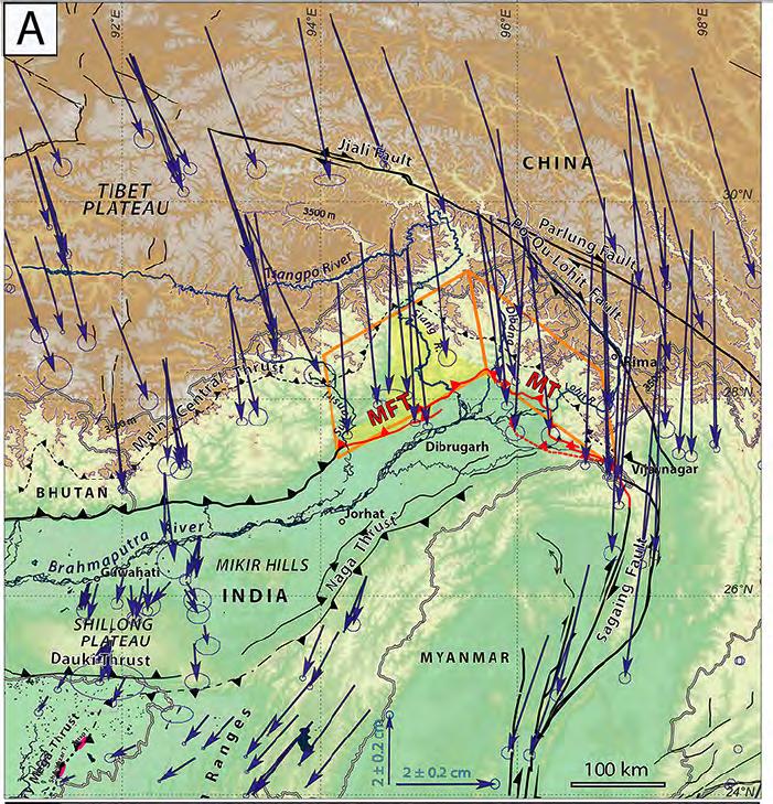
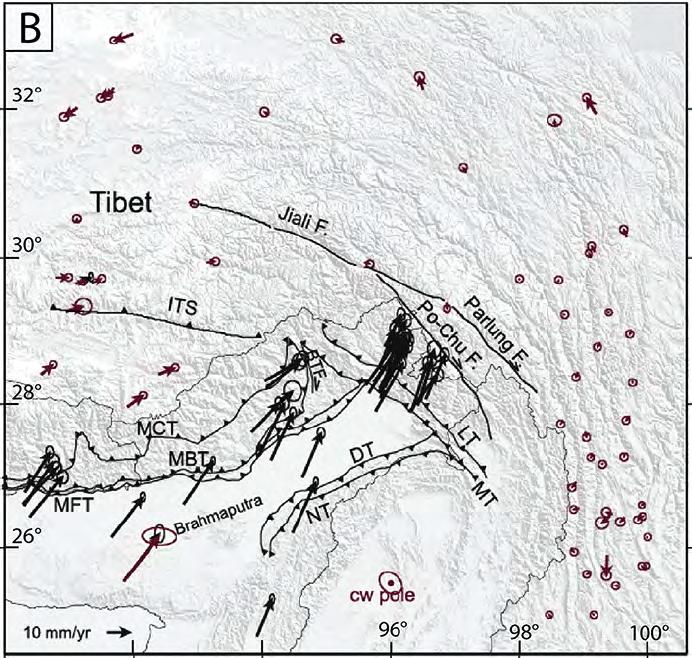
1 Surface rupture of the great Mw 8.6 Assam earthquake in the eastern Himalayas Jérôme Van der Woerd Aurélie Coudurier Curveur (EOS, Singapore) Elise Kali (IPGS, Strasbourg) Paul Tapponnier (EOS, Singapore) Emile Okal (Northwestern University, Evanston, USA) Swapnamita Choudhury (Wadia Inst., Dehra Dun, India) Saurabh Baruah (NEIST, Jorhat, India) This work has been submiued to Science Advances with the Vtle «Dual surface breaks of the great 1950 Assam earthquake across the Mishmi/Abor Hills cusp», Coudurier Curveur et al.


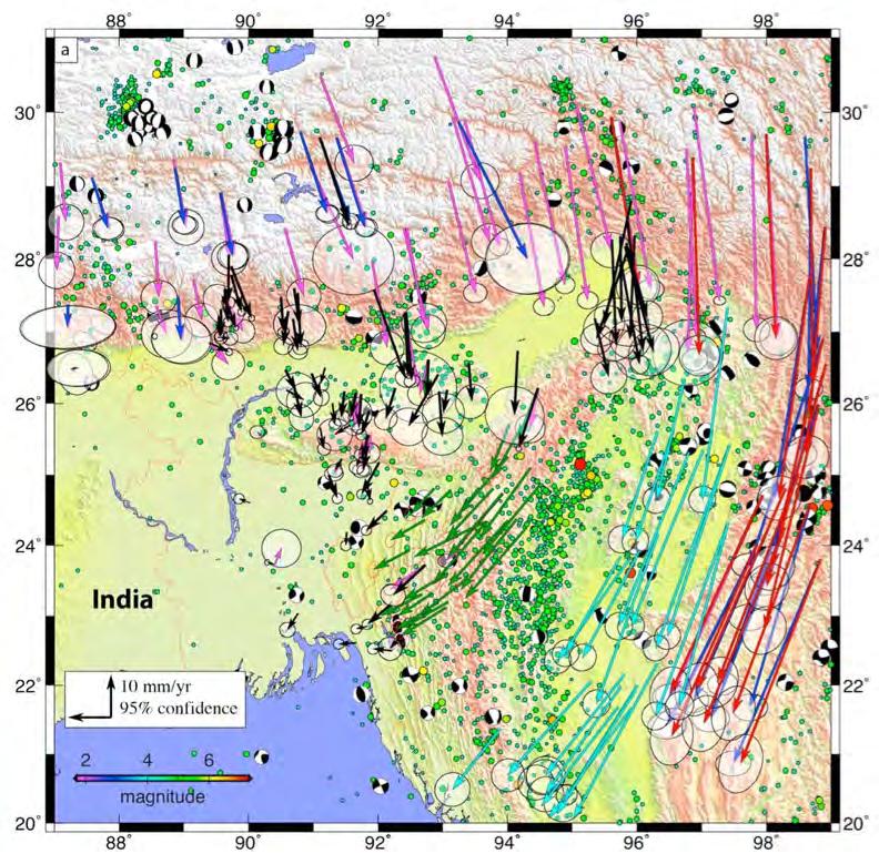
2 Mw 7.5 for the last yrs Seismic slip deficit : where are the earthquakes? Stevens & Avouac,, 2015, 2016

3 Frontal scarp of MFT and surface breaks of the 1934 Bihar Nepal earthquake Sapkota et al., 2012 ; Bollinger et al., 2014

4 Great Himalayan Earthquakes of the 19 th 20 th century may not be blind, afer all Frontal scarp of MFT and surface breaks of teh 1934 Bihar Nepal earthquake Sapkota et al., 2012 ; Bollinger et al., 2014

5 Extension of 1934 Bihar Nepal surface rupture Sapkota et al., 2012 ; Bollinger et al., 2014

6 25 April 2015 Mw 7.8 Gorkha earthquake extension


7 Sub surface complexity of the thrust fault Incomplete historical and geological records Hubbard et al., Geology, 2016
8


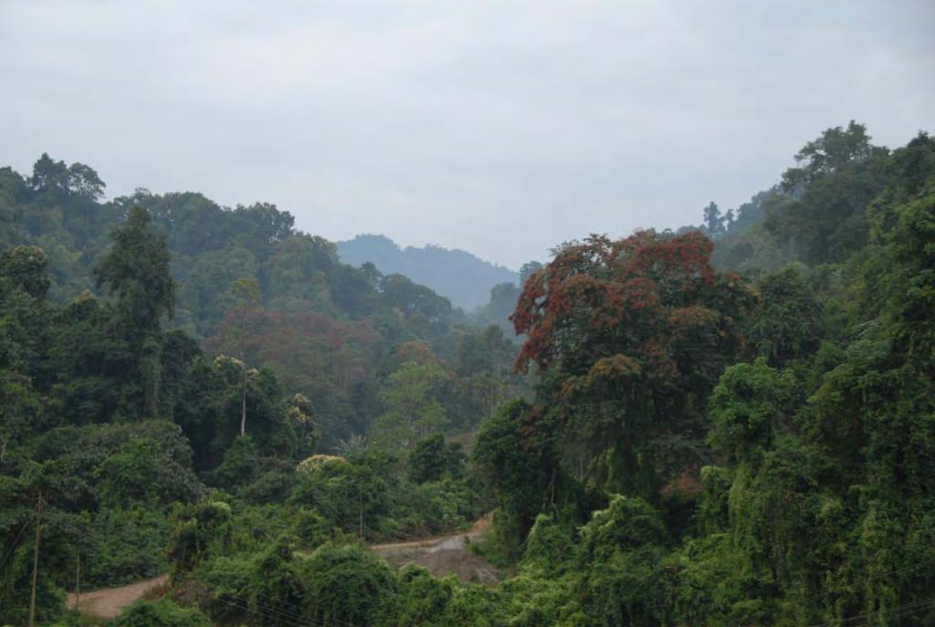
9 Crossing rivers in Assam, the far east India
10
11 Tebang river cut

12 Tebang river cut
13

14 Mishmi thrust outcrop

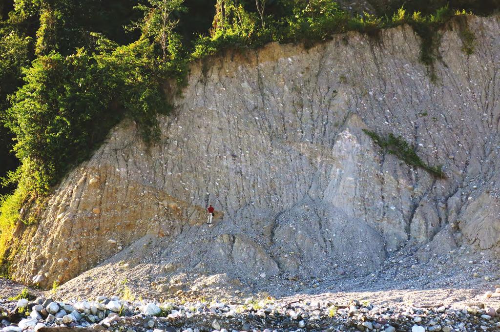
15 10 m high scarp across terrace of Dibang tributary at Roing

16 Decametric scarp of the Mishmi thrust at Roing

17 14 m high scarp across terrace at Wakro

18 Topographic profile across scarp reveals complexity and occurrence of 2 events

19 Scarp across lower terrace along Kamlang river at Wakro

20 Scarp across lower terrace along Kamlang river at Wakro

21 7 m high scarp

22 Rapids in the present day Kamlang river bed Similar to Muzafarabad Kashmir 2005 Mw7.6 or Wenquan 2008 Mw7.9 thrust events

23 Emergence of the Mishmi thrust along a conznuous seismic scarp

24 High resoluzon Pleiades images DEM
25
26 Several meters high scarp in the city of Pasighat

27 Several meters high scarp in the city of Pasighat
28 Several meters high scarp in the city of Pasighat Evidence of step wise growth of the MFT scarp with terrace height


29 Landslides and rock falls, szll aczve in the Abor and Mishmi Hills

30 Remnants of large debris flow loaded with tree trunks

31 Remnants of large debris flow loaded with tree trunks

32 Beheaded trunks, remnants of a forest covered by a massif debris flow, presently eroding

33 Beheaded trunks, remnants of a forest covered by a massif debris flow

34 Landslides and debris flow extension across the Abor and Mishmi hills
35
36
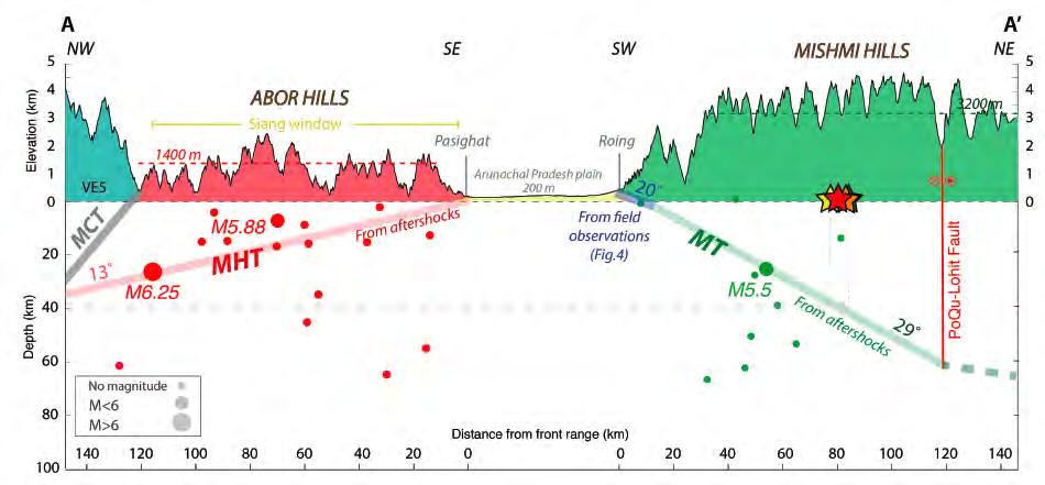
37 Herrin et al., 1962 BenMenahem et al., 1974 Chen and Molnar 1977

38 Chen and Molnar 1977 ; BenMenahem et al., 1974; Herrin et al., 1962 this study
39
40
41


42 Roing Scarp / Depth profile 10Be Measurements of in situ produced cosmogenic 10Be concentrazons in exposed quartz rich boulders and cobbles Surface and sub surface


43 Metric quartz rich block at terrace surface

44 Surface Sub surface Upper terrace south (1700yrs), north (2000yrs) and sub surface (2300yrs) are consistent with abandonment at 2000±200yrs Youngest strath is less than 170 yrs old Consistent with last event in 1950 and penulzmate event between yrs
45 Conclusion - Evidence of recent surface faulting along the Abor and Mishmi hills front associated to the 1950 Assam earthquake - Field observations (continuous scarp up to 330 km, geometry of the scarp, amounts of offsets, landslides extension, ) are in agreement with magnitude and mechanism : - Vertical co-seismic offsets and dip of the MT and MFT imply up to 15 to 30 m of slip, in agreement with magnitude Mw 8.6 derived from long period surface waves - Resulting mechanism combines slip on both the MFT and MT with a major reverse faulting component compatible with first motion polarities - Given present-day geodetic convergence in Assam, about 17 mm/yr, and the maximum amount of slip estimated along the MT implies a recurrence time of about 1700 yrs, in agreement with the return time deduced from cosmogenic isotope dating ( yrs)
46
47
48
49
50
51
52
53
54
55
56

57
58

59


60
61
62
63
Determination of uplift rates of fluvial terraces across the Siwaliks Hills, Himalayas of central Nepal
 Determination of uplift rates of fluvial terraces across the Siwaliks Hills, Himalayas of central Nepal Martina Böhme Institute of Geology, University of Mining and Technology, Freiberg, Germany Abstract.
Down-stream process transition (f (q s ) = 1)
 = 1)") Down-stream process transition (f (q s ) = 1) Detachment Limited S d >> S t Transport Limited Channel Gradient (m/m) 10-1 Stochastic Variation { Detachment Limited Equilibrium Slope S d = k sd A -θ d S
Down-stream process transition (f (q s ) = 1) Detachment Limited S d >> S t Transport Limited Channel Gradient (m/m) 10-1 Stochastic Variation { Detachment Limited Equilibrium Slope S d = k sd A -θ d S
Widespread Ground Motion Distribution Caused by Rupture Directivity during the 2015 Gorkha, Nepal Earthquake
 Widespread Ground Motion Distribution Caused by Rupture Directivity during the 2015 Gorkha, Nepal Earthquake Kazuki Koketsu 1, Hiroe Miyake 2, Srinagesh Davuluri 3 and Soma Nath Sapkota 4 1. Corresponding
Supporting Information for Interseismic Coupling on the Main Frontal Thrust
 JOURNAL OF GEOPHYSICAL RESEARCH Supporting Information for Interseismic Coupling on the Main Frontal Thrust DOI:./ V. L. Stevens and JP Avouac, 4 5 6 7 8 9 Contents of this file. Tables S to S.. Figures
Primary surface ruptures of the great Himalayan earthquakes in 1934 and 1255
 SUPPLEMENTARY INFORMATION DOI: 10.1038/NGEO1669 Primary surface ruptures of the great Himalayan earthquakes in 1934 and 1255 S. N. Sapkota 1, L. Bollinger 2*, Y. Klinger 3, P. Tapponnier 4, Y. Gaudemer
depression above scarp scarp
 1 LAB 1: FIELD TRIP TO McKINLEYVILLE AND MOUTH OF THE MAD RIVER OBJECTIVES: a. to look at geomorphic and geologic evidence for large scale thrust-faulting of young sediments in the Humboldt Bay region
Rupture of a Himalayan Myth
 Jan 14, 2018 1 2 3 4 5 6 7 8 9 10 11 12 13 14 15 16 17 18 19 20 21 22 23 24 25 26 27 28 29 Rupture of a Himalayan Myth Yasuhiro Kumahara 1 kumakuma@hiroshima-u.ac.jp Steven G. Wesnousky 2 * wesnousky@unr.edu
GNGTS 2015 Sessione 1.1
 Intensity-based source inversions of the M8 earthquakes of Bihar-Nepal (1934) and of Assam (1897); fast KF scenario of the M7.8 Gorkha, 2015 earthquake F. Pettenati, L. Sirovich, D. Sandron Istituto Nazionale
Structural Geology and Geology Maps Lab
 Structural Geology and Geology Maps Lab Mesa College Geology 101 Lab Ray Rector: Instructor Structural Geology Lab Pre-Lab Resources Pre-Lab Internet Links 1) Fundamentals of Structural Geology 2) Visualizing
Apparent Himalayan slip deficit from the summation of seismic moments for Himalayan earthquakes,
 Apparent Himalayan slip deficit from the summation of seismic moments for Himalayan earthquakes, 1500 2000 Roger Bilham 1, * and Nicholas Ambraseys 2 1 CIRES and Geological Sciences, University of Colorado
Global Death and Construction: Earthquakes on an Urban Planet
 # 24 Global Death and Construction: Earthquakes on an Urban Planet Dr. Roger Bilham March 21, 2003 Produced by and for Hot Science - Cool Talks by the Environmental Science Institute. We request that the
Neotectonic Implications between Kaotai and Peinanshan
 Neotectonic Implications between Kaotai and Peinanshan Abstract Longitudinal Valley was the suture zone between the Philippine Sea plate and the Eurasia plate. Peinanshan was the southest segment of the
Nepal earthquake of April 25, 2015
 University of Wollongong Research Online Faculty of Engineering and Information Sciences - Papers: Part A Faculty of Engineering and Information Sciences 2015 Nepal earthquake of April 25, 2015 T G Sitharam
Paper presented in the Annual Meeting of Association of American Geographers, Las Vegas, USA, March 2009 ABSTRACT
 Paper presented in the Annual Meeting of Association of American Geographers, Las Vegas, USA, March 2009 ABSTRACT CHANGING GEOMORPHOLOGY OF THE KOSI RIVER SYSTEM IN THE INDIAN SUBCONTINENT Nupur Bose,
Jocelyn Karen Campbell
 THE UNCERTAINTIES IN ASSESSING THE IMPACT OF REGIONAL SEISMICITY AT THE WIL SITE Statement of Evidence by Jocelyn Karen Campbell A CANTERBURY FAULTS coded by type CHARACTERISTICS OF THRUST FAULTS IN CANTERBURY
National Seismological Centre: An Overview, Prospects and Challenges
 National Seismological Centre: An Overview, Prospects and Challenges By Soma Nath Sapkota Department of Mines and Geology National Seismological Centre Nepal India Himalaya Tibetan Plateau India continental
PROBABILISTIC SEISMIC HAZARD ANALYSIS AND ESTIMATION OF SPECTRAL STRONG GROUND MOTION ON BED ROCK IN NORTH EAST INDIA
 4th International Conference on Earthquake Engineering Taipei, Taiwan October 12-13, 2006 Paper No. 015 PROBABILISTIC SEISMIC HAZARD ANALYSIS AND ESTIMATION OF SPECTRAL STRONG GROUND MOTION ON BED ROCK
Learning goals - January 16, Describe the geometry of a fault (1) orientation of the plane (strike and dip) (2) slip vector
 orientation of the plane (strike and dip) (2) slip vector") Learning goals - January 16, 2012 You will understand how to: Describe the geometry of a fault (1) orientation of the plane (strike and dip) (2) slip vector Understand concept of slip rate and how it is
Learning goals - January 16, 2012 You will understand how to: Describe the geometry of a fault (1) orientation of the plane (strike and dip) (2) slip vector Understand concept of slip rate and how it is
Large Himalayan Frontal Thrust Paleoearthquake at Khayarmara in Eastern Nepal
 1 2 3 4 5 6 7 8 9 10 11 12 13 14 15 16 17 18 19 20 21 22 23 24 25 26 27 28 29 30 Large Himalayan Frontal Thrust in Eastern Nepal Steven G. Wesnousky 1 * wesnousky@unr.edu Yasuhiro Kumahara 2 kumakuma@hiroshima-u.ac.jp
5/3/2018 Susceptibility analysis of landslide due to earthquake due in Gorkha (25th April 2015) Animesh Bahadur Pradhan GIS IN WATER RESOURCES CE 547
 Animesh Bahadur Pradhan GIS IN WATER RESOURCES CE 547") Susceptibility 5/3/2018 analysis of landslide due to earthquake due in Gorkha (25th April 2015) Animesh Bahadur Pradhan GIS IN WATER RESOURCES CE 547 Contents 1. Acknowledgement:... 2 2. Motivation and
Susceptibility 5/3/2018 analysis of landslide due to earthquake due in Gorkha (25th April 2015) Animesh Bahadur Pradhan GIS IN WATER RESOURCES CE 547 Contents 1. Acknowledgement:... 2 2. Motivation and
Lecture # 6. Geological Structures
 1 Lecture # 6 Geological Structures ( Folds, Faults and Joints) Instructor: Dr. Attaullah Shah Department of Civil Engineering Swedish College of Engineering and Technology-Wah Cantt. 2 The wavy undulations
Active tectonics of Himalayan Frontal Thrust and Seismic Hazard to Ganga Plain
 Active tectonics of Himalayan Frontal Thrust and Seismic Hazard to Ganga Plain V. C. Thakur Wadia Institute of Himalayan Geology, Dehra Dun 248 001, India We review the existing work on one of the principle
Downloaded from Downloaded from
 IV SEMESTER BACK-PAPER EXAMINATION-2004 Q. [1] [a] Describe internal structure of the earth with a neat sketch. Write down the major land forms and their characteristics on the earth surface. [8] [b] What
Deformation of Rocks. Orientation of Deformed Rocks
 Deformation of Rocks Folds and faults are geologic structures caused by deformation. Structural geology is the study of the deformation of rocks and its effects. Fig. 7.1 Orientation of Deformed Rocks
STRUCTURE AND HOLOCENE SLIP OF THE JID FAULT, MONGOLIA ALTAI
 STRUCTURE AND HOLOCENE SLIP OF THE JID FAULT, MONGOLIA ALTAI LAURA K.O. SMITH AND SARAHTSETSEG PUREDORG Princeton University, Mongolian University of Science and Technology Sponsors: Ramon Gonzalez-Mieres
GLY 155 Introduction to Physical Geology, W. Altermann. Press & Siever, compressive forces. Compressive forces cause folding and faulting.
 Press & Siever, 1995 compressive forces Compressive forces cause folding and faulting. faults 1 Uplift is followed by erosion, which creates new horizontal surface. lava flows Volcanic eruptions cover
Megathrust earthquakes: How large? How destructive? How often? Jean-Philippe Avouac California Institute of Technology
 Megathrust earthquakes: How large? How destructive? How often? Jean-Philippe Avouac California Institute of Technology World seismicity (data source: USGS) and velocities relative to ITRF1997 (Sella et
Chapter 16 Weathering, Erosion, Mass Wasting. Chapter 16 Weathering, Erosion, Mass Wasting. Mechanical Weathering
 Weathering, Erosion and Mass Wasting Weathering is the the breakdown of solid rock at or near the Earth's surface. Chapter 16 Weathering, Erosion, Mass Wasting Does weathering of rock remove or add CO
Determination of fold and fault geometries from faultrelated fold study : A case of Hukou fault in NW Taiwan
 1 Determination of fold and fault geometries from faultrelated fold study : A case of Hukou fault in NW Taiwan Presenter : Dwi Febriana Rochmah Adviser : Wen-Jeng Huang Date : 2016/10/20 Motivation Fold
Probabilistic seismic hazard assessment for Nepal
 Risk Analysis VII PI-45 Probabilistic seismic hazard assessment for Nepal H. Ram Parajuli1, J. Kiyono2, H. Taniguchi1, K. Toki1 & P. Nath Maskey3 1 Ritsumeikan Global Innovation Research Organization,
Pull-apart basin tectonic model is structurally impossible for Kashmir basin, NW Himalaya A. A. Shah
 Pull-apart basin tectonic model is structurally impossible for Kashmir basin, NW Himalaya A. A. Shah Physical & Geological Sciences, Faculty of Science Universiti Brunei Darussalam, Brueni Correspondence
EPS 50 Lab 5 The Hayward Fault at UC Berkeley
 EPS 50 Lab 5 The Hayward Fault at UC Berkeley Introduction: On this field trip we will see some of the most dramatic expressions of the Hayward Fault in the Berkeley area. Most of the subtle geomorphic
How mountains are made. We will talk about valleys (erosion and weathering later)
") How mountains are made We will talk about valleys (erosion and weathering later) http://www.ilike2learn.com/ilike2learn/mountainmaps/mountainranges.html Continent-continent plate convergence Less dense,
How mountains are made We will talk about valleys (erosion and weathering later) http://www.ilike2learn.com/ilike2learn/mountainmaps/mountainranges.html Continent-continent plate convergence Less dense,
The 2015 Mw7.8 Gorkha, Nepal earthquake: Earthquake relocation, seismogenic structure and prospective seismic risk
 The 2015 Mw7.8 Gorkha, Nepal earthquake: Earthquake relocation, seismogenic structure and prospective seismic risk Ling Bai 1, Guohui Li 2, Md Moklesur Rahman 3, Hui Su 4 1. Corresponding Author. Professor,
Strike & Dip. Structural Geology I: Folds & Faults 2009 Lect. 18, J. Steven Kite, West Virginia University
 2 Apr Structural Geology I: Folds & Faults 2009 Lect. 18, J. Steven Kite, West Virginia University Steeply dipping axial plane cleavage. These folded sedimentary layers exposed near Sullivan River in southeastern
Geomorphic Deformation of a Small Glaciofluvial Basin by an Upstream-Facing Thrust Fault over Multiple Glacial Cycles
 1 2 3 4 5 6 7 8 9 10 11 12 13 14 15 16 17 18 19 20 21 22 23 24 25 26 27 Geomorphic Deformation of a Small Glaciofluvial Basin by an Upstream-Facing Thrust Fault over Multiple Glacial Cycles Rachel J. Comp
Slip rates on the Chelungpu and Chushiang thrust faults inferred from a deformed strath terrace along the Dungpuna river, west central Taiwan
 Click Here for Full Article JOURNAL OF GEOPHYSICAL RESEARCH, VOL. 112,, doi:10.1029/2005jb004200, 2007 Slip rates on the Chelungpu and Chushiang thrust faults inferred from a deformed strath terrace along
Inversion of travel times to estimate Moho depth in Shillong Plateau and Kinematic implications through stress analysis of Northeastern India
 Inversion of travel times to estimate Moho depth in Shillong Plateau and Kinematic implications through stress analysis of Northeastern India by Saurabh Baruah Geoscience Division North-East Institute
Center for Neotectonic Studies and Seismological Laboratory, University of Nevada, Reno, NV 89557, USA. 2
 1 2 3 4 5 6 7 8 9 10 11 12 13 14 15 16 17 18 19 20 21 22 23 24 25 26 27 28 29 30 31 32 33 New observations disagree with previous interpretations of surface rupture along the Himalayan Frontal Thrust during
Chapter 2. Earthquake and Damage
 EDM Report on the Chi-Chi, Taiwan Earthquake of September 21, 1999 2.1 Earthquake Fault 2.1.1 Tectonic Background The island of Taiwan is located in the complex junction where the Eurasian and Philippine
Could the Himalaya be Self-Sufficient in Conventional and Unconventional Hydrocarbon Resources
 Could the Himalaya be Self-Sufficient in Conventional and Unconventional Hydrocarbon Resources Sustainable Resource Development in the Himalaya Leh, 24-26 June, 2014 Naveen Hakhoo Distribution of proved
Eric Cowgill. Department of Geology, University of California, Davis, CA 95616, United States
 Earth and Planetary Science Letters 254 (2007) 239 255 www.elsevier.com/locate/epsl Impact of riser reconstructions on estimation of secular variation in rates of strike slip faulting: Revisiting the Cherchen
Should All of Nepal Be Treated as Having the Same Earthquake Hazard?
 Should All of Nepal Be Treated as Having the Same Earthquake Hazard? Seth Stein, Edward M. Brooks, Bruce D. Spencer and Mian Liu Abstract Current earthquake hazard maps for Nepal predict substantial variations
Geotechnical damage in rural areas caused by the 2015 Gorkha Nepal Earthquake
 Tokyo, 1 June 2015 Geotechnical damage in rural areas caused by the 2015 Gorkha Nepal Earthquake Chiaro Gabriele JSPS RESEARCH FELLOW, University of Tokyo Lecturer, University of Canterbury, New Zealand
GPS Strain & Earthquakes Unit 5: 2014 South Napa earthquake GPS strain analysis student exercise
 GPS Strain & Earthquakes Unit 5: 2014 South Napa earthquake GPS strain analysis student exercise Strain Analysis Introduction Name: The earthquake cycle can be viewed as a process of slow strain accumulation
The Quaternary Dextral Shearing in the Southeastern. Tibetan Plateau
 The Quaternary Dextral Shearing in the Southeastern Tibetan Plateau SHEN Jun Wang Yipeng REN Jinwei CAO Zhongquan Institute of Geology of China Seismological Bureau, Beijing 100029, China Tel:8610-62009121,
Introduction Faults blind attitude strike dip
 Chapter 5 Faults by G.H. Girty, Department of Geological Sciences, San Diego State University Page 1 Introduction Faults are surfaces across which Earth material has lost cohesion and across which there
Lab 7: STRUCTURAL GEOLOGY FOLDS AND FAULTS
 Lab 7: STRUCTURAL GEOLOGY FOLDS AND FAULTS This set of labs will focus on the structures that result from deformation in earth s crust, namely folds and faults. By the end of these labs you should be able
San Andreas Movie Can It Happen?
 San Andreas Movie Can It Happen? Learning Objectives (LO) Lecture 14: Faults and Quakes Read: Chapter 10 and 11 Homework #12 due Thursday 12pm What we ll learn today:! 1. Compare strike-slip to dip-slip
Description of faults
 GLG310 Structural Geology Description of faults Horizontal stretch Crustal thickness Regional elevation Regional character Issues Normal Thrust/reverse Strike-slip >1 1 in one direction and < 1 in
ESTIMATION AND SPATIAL MAPPING OF SEISMICITY PARAMETERS IN WESTERN HIMALAYA, CENTRAL HIMALAYA AND INDO-GANGETIC PLAIN
 ESTIMATION AND SPATIAL MAPPING OF SEISMICITY PARAMETERS IN WESTERN HIMALAYA, CENTRAL HIMALAYA AND INDO-GANGETIC PLAIN Monalisha Nayak * * Correspondent Author, Ph.D. Research Scholar, Department of Civil
Team Name. Name(s) SSSS Unome Geologic Mapping Test Packet p1
 SSSS Unome Geologic Mapping Test Packet p1") Scioly Summer Study Session 2018-2019 Geologic Mapping Test Packet Written by Unome Instructions 1) This test is based on the 2016 rules for Geologic Mapping. 2) This test is out of 115 points. Questions
Scioly Summer Study Session 2018-2019 Geologic Mapping Test Packet Written by Unome Instructions 1) This test is based on the 2016 rules for Geologic Mapping. 2) This test is out of 115 points. Questions
Paradoxes of Fluvial Evolution in Young Orogenic Systems
 Journal of Indian Geomorphology Volume 5, 2017 ISSN 2320-0731 Indian Institute of Geomorphologists (IGI) Paradoxes of Fluvial Evolution in Young Orogenic Systems Leszek Starkel Department of Geoenvironmental
How to Build a Mountain and other Geologic Structures. But first a short review
 How to Build a Mountain and other Geologic Structures But first a short review Where do we see deep earthquakes? What is happening there? What can happen at a plate boundary? 1. Plates can move apart
Integrated Interpretation of Gravity, Magnetic & Seismic data for delineation of Basement Configuration in Sadiya Block, Upper Assam, India
 P-225 Integrated Interpretation of Gravity, Magnetic & Seismic data for delineation of Basement Summary G.K.Ghosh *, S.K.Basha, V.K. Kulshreshth Gravity and magnetic data were collected jointly by National
Late Quaternary left-lateral slip rate of the Haiyuan fault, northeastern margin of the Tibetan Plateau
 TECTONICS, VOL. 28,, doi:10.1029/2008tc002302, 2009 Late Quaternary left-lateral slip rate of the Haiyuan fault, northeastern margin of the Tibetan Plateau Chuanyou Li, 1 Pei-zhen Zhang, 1 Jinhui Yin,
Chapter 3. Box counting method for fault system
 Chapter 3 Box counting method for fault system 3.1 Introduction The Himalayan Range with the lofty mass on earth is characterized by very complex structural elements that play a vital role in determining
NUCLEAR POWER PLANT SITE SELECTION
 NUCLEAR POWER PLANT SITE SELECTION ABDELATY B. SALMAN Ex-Chairman Nuclear Materials Authority, Cairo, Egypt I. Introduction The aim of this article is to present the requirements and characteristics for
Lecture 4: Earthquakes and Seismic Waves
 Lecture 4: Earthquakes and Seismic Waves Key Questions 1. What are the sources for EQs in the PNW? 2. What is a seismograph and seismogram? 3. What is the difference between Richter magnitudes and Mercalli
Active Tectonics of Qezel Ozan River Basin, NW Iran
 2011, TextRoad Publication ISSN: 2090-4215 Journal of Applied Environmental and Biological Sciences www.textroad.com Active Tectonics of Qezel Ozan River Basin, NW Iran Mehran Arian *, Ph.D.; Vahid Hosseini
Displacement field and slip distribution of the 2005 Kashmir earthquake from SAR imagery
 Click Here for Full Article GEOPHYSICAL RESEARCH LETTERS, VOL. 33,, doi:10.1029/2006gl027193, 2006 Displacement field and slip distribution of the 2005 Kashmir earthquake from SAR imagery E. Pathier, 1
DR-1, DR-2, DR-3, DR-4, DR-5, DR-6
 GSA Data Repository item 2007216 The influence of large landslides on river incision in a transient landscape: Eastern margin of the Tibetan Plateau (Sichuan, China) William B. Ouimet GSA Bulletin; doi:
Crustal Deformation. (Building Earth s Surface, Part 1) Science 330 Summer Mapping geologic structures
 Science 330 Summer Mapping geologic structures") Crustal Deformation (Building Earth s Surface, Part 1) Science 330 Summer 2005 Mapping geologic structures When conducting a study of a region, a geologist identifies and describes the dominant rock structures
Crustal Deformation (Building Earth s Surface, Part 1) Science 330 Summer 2005 Mapping geologic structures When conducting a study of a region, a geologist identifies and describes the dominant rock structures
ENGINEER S CERTIFICATION OF FAULT AREA DEMONSTRATION (40 CFR )
") PLATTE RIVER POWER AUTHORITY RAWHIDE ENERGY STATION BOTTOM ASH TRANSFER (BAT) IMPOUNDMENTS LARIMER COUNTY, CO ENGINEER S CERTIFICATION OF FAULT AREA DEMONSTRATION (40 CFR 257.62) FOR COAL COMBUSTION RESIDUALS
PLATTE RIVER POWER AUTHORITY RAWHIDE ENERGY STATION BOTTOM ASH TRANSFER (BAT) IMPOUNDMENTS LARIMER COUNTY, CO ENGINEER S CERTIFICATION OF FAULT AREA DEMONSTRATION (40 CFR 257.62) FOR COAL COMBUSTION RESIDUALS
Movement on hidden faults within the Hamilton Basin. Dr Vicki Moon PEngGeol, Dr Willem de Lange & Michael Cummins School of Science
 Movement on hidden faults within the Hamilton Basin Dr Vicki Moon PEngGeol, Dr Willem de Lange & Michael Cummins School of Science Introduction In May 2015 we presented evidence suggesting 3 fault zones
FORMAT FOR TECHNICAL PAPERS
 TOWARDS A MODERNIZED GEODETIC DATUM FOR NEPAL: OPTIONS FOR DEVELOPING AN ACCURATE TERRESTRIAL REFERENCE FRAME FOLLOWING THE APRIL 25, 2015 MW7.8 GORKHA EARTHQUAKE Chris PEARSON 1, Niraj MANANDHA 2 ABSTRACT
S. Toda, S. Okada, D. Ishimura, and Y. Niwa International Research Institute of Disaster Science, Tohoku University, Japan
 The first surface-rupturing earthquake in 20 years on a HERP major active fault: Mw=6.2 2014 Nagano, Japan, event along the Itoigawa-Shizuoka Tectonic Line is not characteristic S. Toda, S. Okada, D. Ishimura,
GEOL/GEOE 344: EARTHQUAKES AND SEISMIC HAZARDS (FALL 2001) FINAL EXAM NAME: TIME AVAILABLE: 120 MINUTES TOTAL POINTS: 110
 FINAL EXAM NAME: TIME AVAILABLE: 120 MINUTES TOTAL POINTS: 110") GEOL/GEOE 344: EARTHQUAKES AND SEISMIC HAZARDS (FALL 2001) FINAL EXAM NAME: TIME AVAILABLE: 120 MINUTES TOTAL POINTS: 110 (yep, that s 10 bonus points, just for showing up!) Instructions: There are several
GEOL/GEOE 344: EARTHQUAKES AND SEISMIC HAZARDS (FALL 2001) FINAL EXAM NAME: TIME AVAILABLE: 120 MINUTES TOTAL POINTS: 110 (yep, that s 10 bonus points, just for showing up!) Instructions: There are several
(1) Identify 5 major principles of relative dating? For each principle, describe how you tell what is younger and what is older.
 Identify 5 major principles of relative dating? For each principle, describe how you tell what is younger and what is older.") Things to Know - Third GLG101Exam Page 1 Important Note: This is not everything you need to know or study. However, it provides you with a relatively comprehensive list of questions to help you study.
Things to Know - Third GLG101Exam Page 1 Important Note: This is not everything you need to know or study. However, it provides you with a relatively comprehensive list of questions to help you study.
Plate Tectonics - Demonstration
 Name: Reference: Prof. Larry Braile - Educational Resources Copyright 2000. L. Braile. Permission granted for reproduction for non-commercial uses. http://web.ics.purdue.edu/~braile/indexlinks/educ.htm
GROUND SURFACE VISUALIZATION USING RED RELIEF IMAGE MAP FOR A VARIETY OF MAP SCALES
 GROUND SURFACE VISUALIZATION USING RED RELIEF IMAGE MAP FOR A VARIETY OF MAP SCALES T. Chiba a, B. Hasi a * a Asia Air Survey Co., Ltd., Kawasaki, Japan (has.baator, ta.chiba,)@ajiko.co.jp Commission II,
Crustal Deformation Earth - Chapter Pearson Education, Inc.
 Crustal Deformation Earth - Chapter 10 Structural Geology Structural geologists study the architecture and processes responsible for deformation of Earth s crust. A working knowledge of rock structures
IV. ENVIRONMENTAL IMPACT ANALYSIS E. GEOLOGY AND SOILS
 IV. ENVIRONMENTAL IMPACT ANALYSIS E. GEOLOGY AND SOILS INTRODUCTION This section evaluates potential impacts related to geology, including seismicity, and soils associated with development of the proposed
Answers: Internal Processes and Structures (Isostasy)
") Answers: Internal Processes and Structures (Isostasy) 1. Analyse the adjustment of the crust to changes in loads associated with volcanism, mountain building, erosion, and glaciation by using the concept
Answers: Internal Processes and Structures (Isostasy) 1. Analyse the adjustment of the crust to changes in loads associated with volcanism, mountain building, erosion, and glaciation by using the concept
Kinematics of the Southern California Fault System Constrained by GPS Measurements
 Title Page Kinematics of the Southern California Fault System Constrained by GPS Measurements Brendan Meade and Bradford Hager Three basic questions Large historical earthquakes One basic question How
Structural Geology Lab. The Objectives are to gain experience
 Geology 2 Structural Geology Lab The Objectives are to gain experience 1. Drawing cross sections from information given on geologic maps. 2. Recognizing folds and naming their parts on stereoscopic air
Sediments and bedrock erosion
 Eroding landscapes: fluvial processes Sediments and bedrock erosion Mikaël ATTAL Marsyandi valley, Himalayas, Nepal Acknowledgements: Jérôme Lavé, Peter van der Beek and other scientists from LGCA (Grenoble)
LAB 5: LANDSLIDE RECOGNITION AND MAPPING
 Geology 350 1 LAB 5: LANDSLIDE RECOGNITION AND MAPPING OBJECTIVES: a. to learn to recognize and classify landslides on airphotos and topographic maps b. to learn to recognize landslide topography on topographic
Displacement (m) measured data one average rate piecewise average Cosmogenic 36Cl age (kyr)
 measured data one average rate piecewise average Cosmogenic 36Cl age (kyr)") Displacement (m) TIMING OF LATE QUATERNARY EARTHQUAKES ON THE HEBGEN LAKE FAULT BY COSMOGENIC CHLORINE-36 DATING OF BEDROCK FAULT SCARP ZREDA, Marek, Department of Hydrology and Water Resources, University
Displacement (m) TIMING OF LATE QUATERNARY EARTHQUAKES ON THE HEBGEN LAKE FAULT BY COSMOGENIC CHLORINE-36 DATING OF BEDROCK FAULT SCARP ZREDA, Marek, Department of Hydrology and Water Resources, University
How the earthquakes and landslides affect Quito, my place. Ecuador is located on the Northwestern part of the South-American plate which is being
 How the earthquakes and landslides affect Quito, my place. Ecuador is located on the Northwestern part of the South-American plate which is being subducted by the Nazca plate. Due to this subduction a
Seismic strain and the state of stress in the crust of the Himalayas
 Seismic strain and the state of stress in the crust of the Himalayas by Emmaline Atherton Department of Earth Sciences, Dalhousie University, Halifax, Nova Scotia Advisor Djordje Grujic Dalhousie University
Study the architecture and processes responsible for deformation of Earth s crust. Folding and Faulting
 Crustal Deformation AKA Structural geology (adapted from Brunkel, 2012) Study the architecture and processes responsible for deformation of Earth s crust. Folding and Faulting How Rocks Deform: 4 Controls
Morphological dating of cumulative reverse fault scarps: examples from the Gurvan Bogd fault system, Mongolia
 Geophys. J. Int. (2002) 148, 256 277 Morphological dating of cumulative reverse fault scarps: examples from the Gurvan Bogd fault system, Mongolia S. Carretier, 1, J-F Ritz, 1 J. Jackson 2 and A. Bayasgalan
Co- seismic and cumulative offsets of the recent earthquakes along the Karakax left- lateral strike- slip fault in western Tibet
 Co- seismic and cumulative offsets of the recent earthquakes along the Karakax left- lateral strike- slip fault in western Tibet Haibing Li, Jerome Van Der Woerd, Zhiming Sun, Jialiang Si, Paul Tapponnier,
Characterisation of late Quaternary displacements on the Waitangi Fault at Aviemore Dam, New Zealand
 Characterisation of late Quaternary displacements on the Waitangi Fault at Aviemore Dam, New Zealand D.J.A. Barrell, R.J. Van Dissen, K.R. Berryman, & S.A.L. Read Institute of Geological & Nuclear Sciences
ENVI.2030L Geologic Time
 Name ENVI.2030L Geologic Time I. Introduction There are two types of geologic time, relative and absolute. In the case of relative time geologic events are arranged in their order of occurrence. No attempt
[ ] Appendix A : Dating results and associated figures. Table A1. Analytical results of cosmogenic dating of 29 samples at site 1.
![[ ] Appendix A : Dating results and associated figures. Table A1. Analytical results of cosmogenic dating of 29 samples at site 1.](/thumbs/84/90992034.jpg "[ ] Appendix A : Dating results and associated figures. Table A1. Analytical results of cosmogenic dating of 29 samples at site 1.") Geophysical Journal International 2002, 147: 356-388. Supplementary material to Van Der Woerd J., P. Tapponnier, F.J. Ryerson, A.S. Mériaux, B. Meyer, Y. Gaudemer, R. Finkel, M. Caffee, Zhao G., Xu Z.,
Geophysical Journal International 2002, 147: 356-388. Supplementary material to Van Der Woerd J., P. Tapponnier, F.J. Ryerson, A.S. Mériaux, B. Meyer, Y. Gaudemer, R. Finkel, M. Caffee, Zhao G., Xu Z.,
Separating Tectonic, Magmatic, Hydrological, and Landslide Signals in GPS Measurements near Lake Tahoe, Nevada-California
 Separating Tectonic, Magmatic, Hydrological, and Landslide Signals in GPS Measurements near Lake Tahoe, Nevada-California Geoffrey Blewitt, Corné Kreemer, William C. Hammond, & Hans-Peter Plag NV Geodetic
Abstract. Betsie Hopper a and Brendan Duffy b a Colorado College, b Department of Geology, University of Canterbury
 1 2 3 4 5 6 7 8 9 New Lidar data reveals slip transfer from the Hope Fault to the Kaikoura Fault Key Terms (Hope Fault, Lidar, Horst-Graben, Jordan Thrust, Kaikoura Fault) Betsie Hopper a and Brendan Duffy
Uplift and incision of the Yakima River Canyon from channel planform mapping and cosmogenic 26 Al/ 10 Be isochron dating
 Uplift and incision of the Yakima River Canyon from channel planform mapping and cosmogenic 26 Al/ 10 Be isochron dating Skyler Sorsby, Colin Amos, Paul Bierman, Kathryn Hansen, Dylan Rood, Burch Fisher,
Future Mw>8 earthquakes in the Himalaya: implications from the 26 Dec 2004 Mw=9.0 earthquake on India's eastern plate margin
 http://www.geo.tv/quake/eq_himalaya_implications.asp Future Mw>8 earthquakes in the Himalaya: implications from the 26 Dec 2004 Mw=9.0 earthquake on India's eastern plate margin Roger Bilham and Kali Wallace
Seth Stein and Emile Okal, Department of Geological Sciences, Northwestern University, Evanston IL USA. Revised 2/5/05
 Sumatra earthquake moment from normal modes 2/6/05 1 Ultra-long period seismic moment of the great December 26, 2004 Sumatra earthquake and implications for the slip process Seth Stein and Emile Okal,
Uplift of the Longmen Shan and Tibetan plateau, and the 2008 Wenchuan (M=7.9) earthquake
 earthquake") Uplift of the Longmen Shan and Tibetan plateau, and the 2008 Wenchuan (M=7.9) earthquake Judith Hubbard 1,* & John H. Shaw 1 1 Department of Earth and Planetary Sciences, Harvard University, 20 Oxford
Uplift of the Longmen Shan and Tibetan plateau, and the 2008 Wenchuan (M=7.9) earthquake Judith Hubbard 1,* & John H. Shaw 1 1 Department of Earth and Planetary Sciences, Harvard University, 20 Oxford
A GEOLOGIC TRIP to the SAN ANDREAS FAULT
 A GEOLOGIC TRIP to the SAN ANDREAS FAULT San Andreas Hot Spot Loop Road Hot Spot P Parking San Andreas Fault Interpretive Trail Fault Zone Map: San Andreas Fault Zone During the 25 million years that the
The Earthquake of Padang, Sumatra of 30 September 2009 scientific information and update
 The Earthquake of Padang, Sumatra of 30 September 2009 scientific information and update 01-October-2009 Christophe Vigny Directeur de recherches at CNRS Laboratoire de Géologie Geoscience Dept. Of ENS,
Geometry of co-seismic surface ruptures and tectonic meaning of the 23 October 2011 Mw 7.1 Van earthquake (East Anatolian Region, Turkey)
") Geometry of co-seismic surface ruptures and tectonic meaning of the 23 October 2011 Mw 7.1 Van earthquake (East Anatolian Region, Turkey) Bülent Dogan & Ahmet Karakaș. Journal of Structural Geology, 46(2013),
Geometry of co-seismic surface ruptures and tectonic meaning of the 23 October 2011 Mw 7.1 Van earthquake (East Anatolian Region, Turkey) Bülent Dogan & Ahmet Karakaș. Journal of Structural Geology, 46(2013),
MEMO. TO: Dennis Lapoint CC: FROM: Eriaan Wirosono DATE: April, 20 th 2014 SUBJECT: Exploration activity report March-April 2014_EW
 TO: Dennis Lapoint CC: FROM: Eriaan Wirosono DATE: April, 20 th 2014 SUBJECT: Exploration activity report March-April 2014_EW MEMO 1. Highlights and Productivity Overview pan sampling on target Areas 1
Revisiting State of Stress and Geodynamic Processes in Northeast India Himalaya and Its Adjoining Region
 Geosciences 2013, 3(5): 143-152 DOI: 10.5923/j.geo.20130305.01 Revisiting State of Stress and Geodynamic Processes in Northeast India Himalaya and Its Adjoining Region A. Panthi 1, H. N. Singh 2, D. Shanker
Geological Studies in the Larsemann Hills, Ingrid Chirstensen Coast, East Antarctica
 363 Twenty Fourth Indian Antarctic Expedition 2003-2005 Ministry of Earth Sciences, Technical Publication No. 22, pp 363-367 Geological Studies in the Larsemann Hills, Ingrid Chirstensen Coast, East Antarctica
EPS 50 Lab 6: Maps Topography, geologic structures and relative age determinations
 Name: EPS 50 Lab 6: Maps Topography, geologic structures and relative age determinations Introduction: Maps are some of the most interesting and informative printed documents available. We are familiar