LOCATION RESTRICTIONS DEMONSTRATION REPORT CCR LANDFILL
|
|
|
- Magnus Mosley
- 5 years ago
- Views:
Transcription

1 LOCATION RESTRICTIONS DEMONSTRATION REPORT CCR LANDFILL Sibley Generating Station Presented to: KCP&L Greater Missouri Operations Company Sibley Generating Station Sibley, Missouri October W 110 th Street, Suite 100 Overland Park, Kansas
2 Location Restrictions Demonstration Report Table of Contents Section Page 1 INTRODUCTION AND PURPOSE UNSTABLE AREAS ( ) Unstable Factors Considered: Differential Settling ( (b)(1)) Unstable Factors Considered: Geologic/Geomorphologic Features ( (b)(2)) Unstable Factors Considered: Human-made Features or Events ( (b)(3)) REFERENCES QUALIFIED PROFESSIONAL ENGINEER CERTIFICATION ( (c))... 7 LIST OF FIGURES AND APPENDICES FIGURES Figure 1 Site Location Map APPENDICES Appendix A Appendix A.1 Appendix A.2 Appendix A.3 Unstable Areas Supporting Information Portions of Previous Reports - Portions of Detailed Hydrogeologic Site Characterization Report (AECOM 2017) - Portions of Permit Application and Operating Plan for Solid Waste Disposal Area (Burns & McDonnell, 1987) Geologic/Geomorphologic Features Documentation - Portions of Detailed Hydrogeologic Site Characterization Report (AECOM 2017) - Sinkholes in Missouri (MDNR) - Geologic Hazards in Missouri (MDNR, 2015) - GeoSTRAT Database Review Human-made Features or Events Documentation - Mine Maps Jackson County (MDNR) - Oil and Gas in Missouri Fact Sheet (MDNR) - Mineral Resources in Missouri (MDNR) - Missouri Coal (MDNR) CCR Landfill Sibley Generating Station i
3 Location Restrictions Demonstration Report 1 INTRODUCTION AND PURPOSE The Disposal of Coal Combustion Residuals (CCR) from Electric Utilities Final Rule (CCR Rule) 40 CFR through requires owner/operators of existing CCR units to make demonstrations in the event a unit is located in certain areas. The purpose of this report is to demonstrate whether the CCR Landfill (Unit) at KCP&L Greater Missouri Operations Company (KCP&L GMO) Sibley Generating Station (Sibley) is located in any of those areas; and, if so, to make certain demonstrations per the CCR Rule that will permit continued CCR disposal/management operations. The Unit, which is an existing CCR landfill, is located at the Sibley Generating Station in Jackson County, Missouri, as indicated in Figure 1. SCS Engineers (SCS) has reviewed the documents provided in Section 3 and completed site visit(s) to develop this report. This document provides demonstrations that documents if the Unit is located: in an unstable area (40 CFR ). The applicable CCR Rule requirement for the above is listed in Section 2 in italics followed by an explanation of the review and determinations completed by SCS. CCR Landfill Sibley Generating Station 1
4 Location Restrictions Demonstration Report 2 UNSTABLE AREAS ( ) (a) An existing or new CCR landfill, existing or new CCR surface impoundment, or any lateral expansion of a CCR unit must not be located in an unstable area unless the owner or operator demonstrates by the dates specified in paragraph (d) of this section that recognized and generally accepted good engineering practices have been incorporated into the design of the CCR unit to ensure that the integrity of the structural components of the CCR unit will not be disrupted. SCS evaluated the location of the Unit for the presence of on-site or local unstable areas as defined in Evaluations of the conditions listed in (b)(1) through (3) were evaluated and are discussed below. Based on this review, SCS determined the Unit is not located within an unstable area as defined in Consequently, no additional demonstration is necessary (b) The owner or operator must consider all of the following factors, at a minimum, when determining whether an area is unstable: 2.1 UNSTABLE FACTORS CONSIDERED: DIFFERENTIAL SETTLING ( (b)(1)) On-site or local soil conditions that may result in significant differential settling; SCS has visited the Unit and evaluated site-specific reports detailing the conditions of the onsite and local soils for conditions that could result in significant differential settling. The site was characterized in the Detailed Hydrogeologic Site Characterization Report, CCR Landfill (DSI) prepared by AECOM in October The Sibley Generating Station is located along within the Missouri River within the Osage Plains physiographic section (MDNR, 2002). The geomorphology is defined by gently rolling hills, with typically soft shale bedrock interbedded with sandstones and limestones characterized by a series of east-facing escarpments that indicate the presence of more resistant bedrock units (typically limestone) in the surficial rocks. A series of Pleistocene ice sheets extended into the northern portion of Jackson County, leaving glacial till deposited predominantly along the Missouri River valley and in the Buckner-Sibley area. A large portion of northern Jackson County along the Missouri River is covered in a deep deposit of wind-deposited silt associated with the Pleistocene glaciation. The thickest deposits are observed along the bluffs of the Missouri River. Generally, the alluvial deposits on the south side of the Missouri River are thin, between feet thick, and somewhat fine grained with a coarsening sequence of primarily clay, with silt, sand, and some gravel. Alluvial deposits on the north side of the Missouri River are estimated to be approximately 100 feet deep, and have a more pronounced transition from overlying clay to sand to boulders with depth (Gentile, 2014). The Permit Application (Burns & McDonnell, 1987) and DSI (AECOM, 2017) investigation indicate that the landfill is located in an area where the bedrock has been overlain by thick overburden deposits of loess and glacial till. The soil stratigraphy at the Sibley Ash Landfill area consists of topsoil and loess to depths of 17 to 36 feet, glacial till with a thickness of up to 30 feet, and sandstones and shales of the Pennsylvanian-aged Pleasanton Group as wells as the Holdenville and Appanoose Subgroups of the Marmaton Group. CCR Landfill Sibley Generating Station 2
5 Location Restrictions Demonstration Report The loess thickness ranges from 15 to 34 feet, but is generally 20 to 25 feet. The loess consists of a reddish-brown to gray silty clay or clayey silt, generally classified as a CL, mottled with rust coloring and some organics. The loess is underlain by glacial till consisting of low to medium plastic silty clay, classified as a CL or CH, at depths ranging from 15 to 34 feet. Bedrock at the site was encountered at depths ranging from 24 to 48 feet and consists of alternating layers of sandstones and shales of the Pleasanton group. The permit application shows the landfill was constructed in the loess layer, above the till layer. Based on the geologic description above and a review of geotechnical data in the report(s), it is SCS professional opinion that the soils under the Unit will not experience significant differential settlement. Pertinent sections of the Permit Application (Burns & McDonnell, 1987) and the DSI (AECOM, 2017) report are provided in Appendix A.1 summarizing the soil properties at and near the Unit. Based on this review, SCS determined the Unit is not located within an area with on-site or local soil conditions that may result in significant differential settling. Additional demonstration(s) are not required. 2.2 UNSTABLE FACTORS CONSIDERED: GEOLOGIC/GEOMORPHOLOGIC FEATURES ( (b)(2)) On-site or local geologic or geomorphologic features; and SCS has visited the Unit and evaluated published data and site-specific reports for the presence of on-site or local geologic and geomorphologic features, to include karst terrain, steep slopes, and sinkholes. Documents and websites reviewed include: MDNR Geologic and Related Hazards in Missouri ( Sinkholes in Missouri ( Map of Sinkholes in Missouri ( SCS also used the Missouri Geologic Survey Geosciences Technical Resource Assessment Tool (GeoSTRAT) ( database to identify geologic and geomorphologic features that may have an impact on the Unit. Data layers examined by SCS included the following: Geologic Structures, Earthquake Collapse Potential, Earthquake Liquefaction Potential, Mines, Springs, Cave Density, Sinkhole Areas, and Sinkhole Points. As shown on the GeoSTRAT map in Appendix A.2, only a geologic structure was identified within the search area near the Unit. The geologic structure should not have an impact on the Unit. CCR Landfill Sibley Generating Station 3
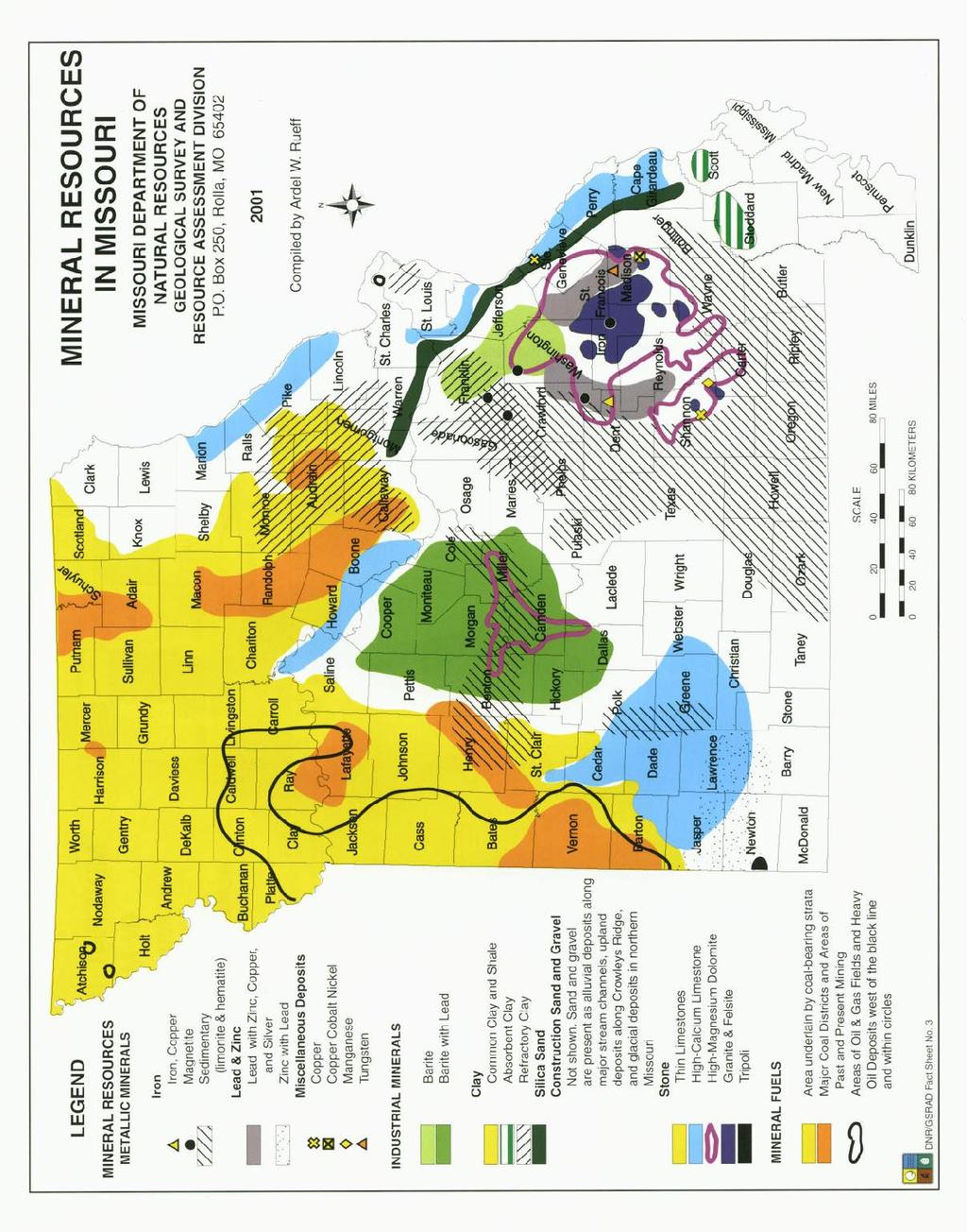
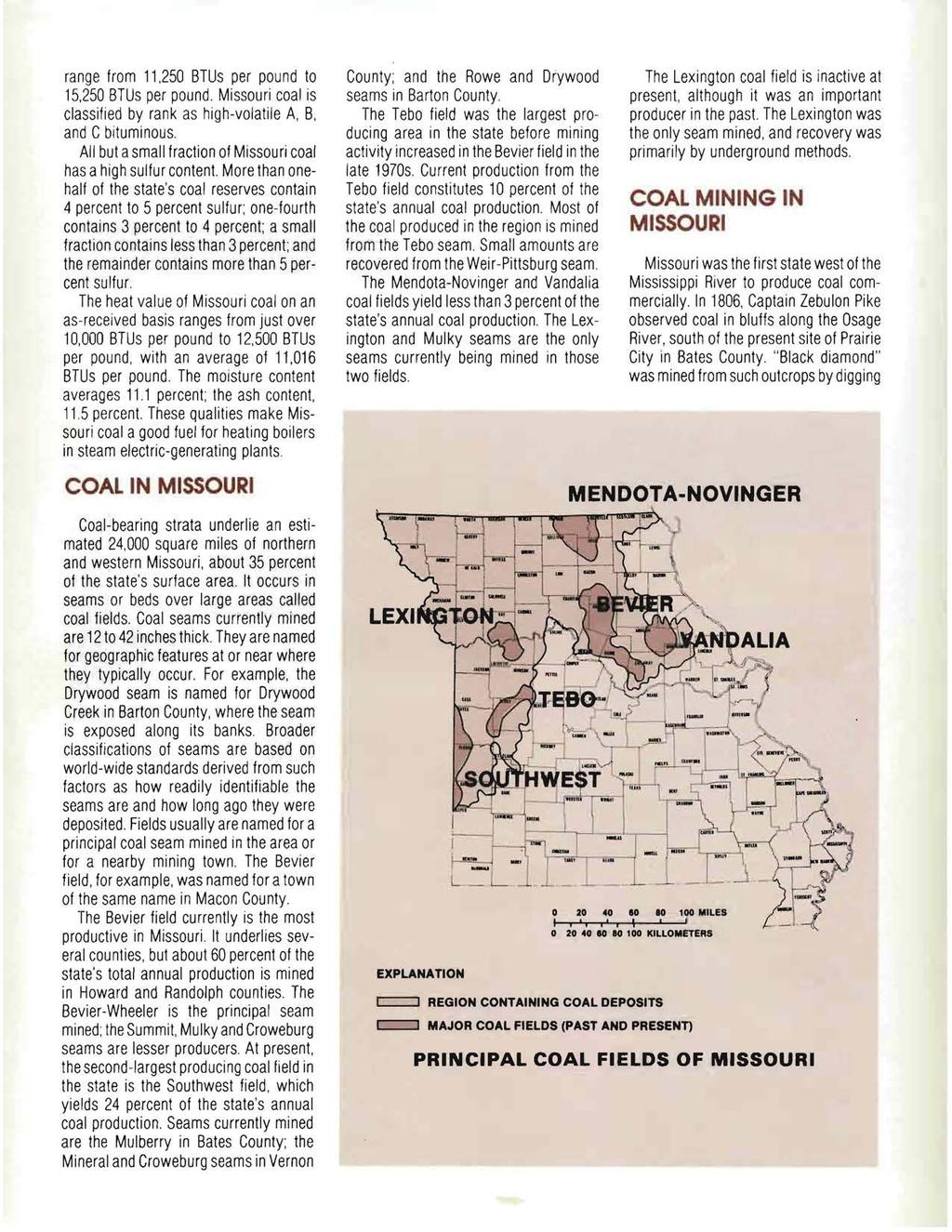
6 Location Restrictions Demonstration Report Neither the GeoSTRAT database nor published data indicate the presence of karst terrain, sinkholes, caves, or ground conditions that could cause a structural failure in the area of the Unit or region around the Unit. Locally, three structural features are noted in the bedrock geology near the Unit (Gentile, 2014). They include a west-southeast trending anticline, a complimentary west-southeast trending syncline, and several buried bedrock incised paleovalleys south of the Missouri river (AECOM, 2017). A map showing the general structural features near the Unit is included in Appendix A.2. SCS visits to the site and a review of terrain at and near the Unit indicated no steep slopes, terrain features, or other local geologic or geomorphologic features that could feasibly result in an unstable condition. Pertinent documents and sections of documents reviewed are provided in Appendix A.2, and indicate the location of the Unit in relation to the known geologic or geomorphologic features nearest the Unit. Based on this review, SCS determined the Unit is not located within an area with on-site or local geologic or geomorphologic features that would result in an unstable environment for the Unit. 2.3 UNSTABLE FACTORS CONSIDERED: HUMAN-MADE FEATURES OR EVENTS ( (b)(3)) On-site or local human-made features or events (both surface and subsurface). SCS has visited the Unit and evaluated published data and site-specific reports for the presence of on-site or local human-made features or events (both surface and subsurface), to include surface and subsurface mining, extensive withdrawal of oil and gas, steep slopes, and sources of rapid groundwater drawdown, in strata that could feasibly impact the Unit. Documents and websites reviewed include: Missouri Mine Maps ( Mine Maps Jackson County ( Oil and Gas in Missouri, Fact Sheet ( Oil and Gas in the Show-Me State, The Geologic Column of Missouri, published by the MDNR Division of Geology and Land Survey, Volume 2, Issue 1, Summer 2007 SCS used the Missouri GeoSTRAT database to identify man-made features or events that may have an impact on the Unit. Data layers examined by SCS included the following: Inventory of Mines, Occurrences and Prospects, Industrial Mineral Mines, and Oil and Gas Wells. The GeoSTRAT maps indicated the presence of mines and oil and gas production in Jackson County. The mining in the area of the City of Sibley, Missouri consists of mining to the west of Township 50 North, Range 30 West where numerous underground limestone mines exist. Underground mining is ongoing approximately 10 miles west of the Unit, as well as north of Missouri River in Clay County. The GeoSTRAT database showed the location of oil/gas wells in Jackson County, but no oil/gas wells within 4 miles of the Unit. CCR Landfill Sibley Generating Station 4
7 Location Restrictions Demonstration Report No evidence of steep slopes in the vicinity of the unit nor areas of rapid groundwater drawdown were identified. Selected pertinent documents and sections of documents are provided in Appendix A.3 to indicate the types and locations of human-made features in this area of Missouri and their locations relative to the Unit. Based on this review, SCS determined the Unit is not located within an area with on-site or local human-made features or events (both surface and subsurface) that could feasibly result in an unstable condition at the Unit. CCR Landfill Sibley Generating Station 5
8 Location Restrictions Demonstration Report 3 REFERENCES AECOM (2017), Detailed Hydrogeologic Site Characterization Report, CCR Landfill, Sibley Generating Station. Burns & McDonnell (1987 Revised 1988), Permit Application and Operating Plan for Solid Waste Disposal Area, Fly Ash Landfill, Sibley Generating Station. MDNR (2002), Physiographic Regions of Missouri, Division of Geology and Land Survey, Missouri Department of Natural Resources. USGS (2015), Geologic Units in Jackson County, Missouri, accessed August MDNR, MDNR Geologic and Related Hazards in Missouri, accessed August MDNR (2015), Geologic Hazards in Missouri, accessed August MDNR, Sinkholes in Missouri, accessed August MDNR, Map of Sinkholes in Missouri, accessed August 2018 MDNR, Missouri Geologic Survey Geosciences Technical Resource Assessment Tool (GeoSTRAT), accessed August MDNR, Missouri Mine Maps, accessed August MDNR, Mine Maps Jackson County, accessed August MDNR, Oil and Gas in Missouri, Fact Sheet, accessed August CCR Landfill Sibley Generating Station 6
) The undersigned registered professional engineer is familiar with the requirements of the CCR Rule and has visited and examined the Unit and/or has supervised examination of the Unit and")
9 Location Restrictions Demonstration Report 4 QUALIFIED PROFESSIONAL ENGINEER CERTIFICATION ( (C)) The undersigned registered professional engineer is familiar with the requirements of the CCR Rule and has visited and examined the Unit and/or has supervised examination of the Unit and development of this report by appropriately qualified personnel. I hereby certify based on a review of available information and observations, that this report meets the requirements of paragraph (a). Professional Engineer: Company: Douglas L. Doerr, P.E. SCS Engineers PE Registration State: Missouri Registration Number: PE Professional Engineer Seal: Douglas L. Doerr CCR Landfill Sibley Generating Station Digitally signed by Douglas L. Doerr Date: :04:25-05'00' 7
10 Location Restrictions Demonstration Report FIGURES Figure 1 - Site Location Map CCR Landfill Sibley Generating Station
 681-0012 FIGURE 1 SITE LOCATION MAP KCP&L GMO SIBLEY GENERATING STATION - CCR LANDFILL SIBLEY,")
11 SCS ENGINEERS 8575 W. 110th St, STE. 100 Overland Park, Kansas PH. (913) efax. (913) FIGURE 1 SITE LOCATION MAP KCP&L GMO SIBLEY GENERATING STATION - CCR LANDFILL SIBLEY, MISSOURI 1
12 Location Restrictions Demonstration Report APPENDIX A Unstable Areas Supporting Information CCR Landfill Sibley Generating Station
13 Location Restrictions Demonstration Report APPENDIX A.1 Portions of Previous Reports Portions of Detailed Hydrogeologic Site Characterization Report (AECOM, 2017) Portions of Permit Application and Operating Plan for Solid Waste Disposal Area (Burns & McDonnell, 1987) CCR Landfill Sibley Generating Station
14 AECOM Detailed Hydrogeologic Site Characterization Report CCR Landfill KCP&L GMO Sibley Generating Station Introduction with 10 CSR (MDNR, 2007A) for an expansion of the CCR Landfill to the current permitted area. KCP&L GMO received the landfill construction permit for the Sibley Utility Waste Landfill Expansion Stage A (Permit Number ) from the MDNR on September 10, 2009, as documented in the Sibley Utility Waste Landfill Stage A Operating Permit Application (URS, 2010A). The 25-acre expansion increased the total permitted waste footprint of the CCR Landfill to approximately 46.5 acres. Stage A was completed in 2010 (URS, 2010A). Approximately 22.2 acres has been constructed as of According to engineering drawings (Burns and McDonnell, 1988 and AECOM, 2010), the base grade of the CCR Landfill ranged from approximately 800 ft. to 760 ft. (unless otherwise noted, all elevations in this report are in a plant datum as defined in "URS Plans For Construction, KCP&L Sibley Generating Station, Design File , Dated January 2010"), with the lowest elevation in the northwest corner and the highest along the southern extent. Design drawings include a two feet thick compacted soil liner under the entire footprint of the landfill, and a geomembrane liner under the initial 5-acre (approximate) northern expansion area. A sedimentation pond, originally located in the existing northwest corner of the landfill, was closed prior to the initial expansion. 1.3 Regional Geology and Hydrogeology Geomorphology The Sibley Station is located along the Missouri River and is situated within the Osage Plains physiographic section of the larger Central Lowland province, which is in turn part of the larger Interior Plains physiographic division (MDNR, 2002). The geomorphology is defined by gently rolling hills, with typically soft shale bedrock interbedded with sandstones and limestones characterized by a series of east-facing escarpments that indicate the presence of more resistant bedrock units (typically limestone) in the surficial rocks. The Dissected Till Plains physiographic section, also included in the Central Lowlands province, begins just north of the Missouri River, and is characterized by former plains that have been covered by glacial drift, with subsequent development of welldefined drainage systems (Fenneman, 1928). Local surface topographic relief is typically less than 250 ft. with greatest relief occurring where major streams incise the underlying rocks (Fenneman, 1928, Imes and Emmett, 1994). A series of Pleistocene ice sheets extended into the northern portion of Jackson County, leaving glacial till deposited predominantly along the Missouri River valley and in the Buckner-Sibley area. A large portion of northern Jackson County along the Missouri River is covered in a deep deposit of loess winddeposited silt associated with the Pleistocene glaciation. The thickest deposits are observed along the bluffs of the Missouri River. Generally, the alluvial deposits on the south side of the Missouri River are thin, between ft. thick, and somewhat fine grained with a coarsening sequence of primarily clay, with silt, sand, and some gravel. Alluvial deposits on the north side of the Missouri River are estimated to be approximately 100 ft. deep, and have a more pronounced transition from overlying clay to sand to boulders with depth (Gentile, 2014). The regional drainage pattern is generally dendritic (United States Department of Agriculture (USDA), 2007). The area is part of the larger Lower-Missouri-Crooked River Watershed (EPA, 2017), and the major stream in this area is the Missouri River. The Site is located on the southern banks of the Missouri River, which flows eastsoutheasterly past the Site. The area surrounding the Sibley Station consists of undulating hills that form a series of ridges overlooking the south side of the Missouri River floodplain. The landscape is cut by a series of deeply incised ravines that flow to the north toward the Missouri River. The largest of these ravines is located along the east side of the CCR Landfill, extending from Twiehaus Road northward to the Missouri River. A second ravine is located northwest 1-2 October 2017
15 PART I SITE GEOLOGY The site for the proposed fly ash landfill is located approximately 1.5 miles east of Sibley, Missouri, along the Missouri River. The landfill is to be located on the loess bluffs which form the southern boundary of the Missouri River floodplain. The elevations of the bluffs range from approximately 750 feet to 820 feet above Mean Sea Level. In order to obtain subsurface information, 20 soil borings were drilled at the site. The glacial till strata was fully penetrated in only six of the 20 borings. The till was encountered to a maximum depth of 48 feet in Borings B-14 and B-17. The glacial till is composed of a reddish-brown to tan clay which is generally very stiff. There are traces of fine sand present throughout the glacial till matrix. The amount of sand generally appears to increase with depth in the till stratum. The proposed site occurs in an area where the bedrock has been blanketed by thick soil overburden deposits. These deposits consists of, from the ground surface downward, (1) silty topsoil approximately feet thick; (2) loess (wind deposited silt, 1n some places redeposited by erosion) 15 to 34 feet thick, (3) glacial till, thickness ranges up to as much as approximately 30 feet, directly overlying the bedrock. MPl.SI I-1
16 The loess, which forms a thick blanket over much of the site, 1s on the average of feet thick but may be thinner or thicker in some areas. The loess consists of silty clay varying in color from reddish-brown to gray with rust colored mottling and some organics. The moisture content varies from moist to wet and a plasticity varying from low to medium plastic. Two reports on the soil properties of the region provide pertinent information on suitability of the soil materials found at the site for construction of a facility of this type. Both reports indicate that the site is well suited for landfill construction, if consideration is given to particular soil engineering properties which require special design features, handling procedures, and seeding. The first report is the U.S. Soil Conservation Survey report on the Soil Survey of Jackson County, Missouri. That report indicates that most of the soils in the active landfill area belong to the Knox silt loam, 5 to 9 percent slopes. A large area on the top of the hill is assigned to the Sibley silt loam, 2 to 5 percent slopes. The wooded side slopes around the edge of the site (outside the active fill area) have soils assigned to the Knox silty clay loam, 5 to 14 percent slopes, severely eroded, and Knox silt loam, 14 to 20 percent slopes. Thus, the active area of the fill is predominantly in Knox silt loam, with some Sibley silt loam. The Knox silt loam, 5 to 9 percent slopes, which comprises the bulk of the active landfill area 1s reported to have good properties for daily landfill I-2 MPl.SI
17 PART III SUBSURFACE CONDITIONS A. SUBSURFACE MATERIALS ENCOUNTERED The locations of two geologic profiles which illustrate the generalized subsurface conditions at the site are shown on Figure III-1. The geologic profiles are shown on Figures III-2 and III-3. The site is generally covered by approximately 0.4 to 1.5 feet of topsoil classified as silty clay with some roots. The topsoil is underlain by a layer of loess consisting of low to medium plastic silty clay to approximate depths ranging from 15 feet in Boring B-7 to 34 feet in Boring B-17. The loess is underlain by glacial till consisting of medium to highly plastic silty clay and clay. The till was encountered to a maximum depth of 48 feet in Boring B-17. Individual samples from several borings in the till layer were classified to be sandy silt, sandy clayey silt, sandy clay, and clayey sand, however, these appear to be laterally discontinuous materials which vary in thickness. Bedrock was encountered in six of the borings drilled for this investigation at depths ranging from 24 feet in Borings B-5 and B-7 to 48 feet in Borings B-14 and B-17. The bedrock materials which are described in Part I, Site Geology, of this report are all located below the proposed bottom elevation of the landfill and will not conflict with the landfill design or construction. MP3.SI III-1
18 Location Restrictions Demonstration Report APPENDIX A.2 Geologic/Geomorphologic Features Documentation Portions of Detailed Hydrogeologic Site Characterization Report (AECOM 2017) Sinkholes in Missouri (MDNR) Geologic Hazards in Missouri (MDNR, 2015) GeoSTRAT Database Review CCR Landfill Sibley Generating Station
19 AECOM Detailed Hydrogeologic Site Characterization Report CCR Landfill KCP&L GMO Sibley Generating Station Introduction At the Sibley Station, the CCR Landfill is underlain by unconsolidated loess and glacial drift and then undifferentiated bedrock assigned to the Pleasanton Group as well as the Holdenville and Appanoose Subgroups which outcrop in the ravines below the landfill. The nearby Fly Ash Impoundment lies on the Missouri River floodplain and is underlain by unconsolidated floodplain alluvium and undifferentiated bedrock assigned to the Appanoose Subgroup. The nearby Slag Settling Impoundment is underlain by unconsolidated floodplain alluvium and undifferentiated bedrock assigned to the Fort Scott Subgroup. The Site stratigraphy is illustrated in a regional stratigraphic column provided in Figure B.2 in Appendix B. The general surficial geologic map of the Site is provided in Figure B.3 in Appendix B. The general geologic map of Pennsylvanian bedrock units is provided in Figure B.4 in Appendix B. A few small faults have been identified in Jackson County (McCourt, 1917). The most noticeable is located in a creek 2.5 miles west of Lee s Summit (approximately 20 miles south of the Site) where the creek crosses between Sections 2 and 11, Township 47 North, Range 32 West. Just south of this point, the Hertha Limestone member is sharply folded and fractured. The fold axis strikes at north 25 west. A short distance to the north along the Rock Island Railroad, the Bethany Falls and Winterset Limestones are faulted. The fault in this area has a throw of 7 ft., a strike of north 23 west, and a dip of 47 south 67 west. Seismic risk in the area is considered to be low, additional hazard assessment may be referred to in existing DSI documentation for the Site (Shaw, 2008). Structural contours of the Raytown Limestone identified a syncline in northwest Kansas City with a northwest to southeast orientation (McCourt, 1917). The greatest deformation is 50 ft. with the width ranging from 1 to 2 miles. A series of minor folds near normal to the axis have a deformation of less than 35 ft. and a general strike of north 70 east. Dome-like structures occur where anticlinal axes cross. Locally, three structural features are noted in the bedrock geology near the Site (Gentile, 2014). They include a west-southeast trending anticline, a complimentary west-southeast trending syncline, and several buried bedrock incised paleovalleys south of the Missouri river. A map showing the general structural features near the Site is included as Figure B.4 in Appendix B Hydrogeologic Setting Surface Hydrology The CCR Landfill is located on a topographic high which drops off dramatically to the north down to the Missouri River floodplain. Twiehaus Road is the approximate southern divide for the watershed. In general, the surface water runoff drains north to the Missouri River. The primary surface drainage features which receive surface water runoff from the landfill area are two deeply incised ravines, as shown in Figure A.3 in Appendix A. Most of the surface runoff to the east of the Site, including the east portion of the existing landfill, is captured by the east ravine. The watershed for the area west of the landfill extends to the south to Twiehaus Road, west to approximately 900 ft. west of the farm pond, and east to the landfill. Most of the surface water runoff west of the Site appears to be captured by the southwest branch of the west ravine and is retained in the farm pond. A portion of the runoff currently flows through the center of the area west of the landfill via the southeast branch of the west ravine (Shaw, 2008). Appendix A, Figure A.3 presents a hydrologic map of the area. Major bodies of water, streams, and drainage courses are shown Subsurface Hydrology The primary unconsolidated aquifers in northern Jackson County are associated with alluvial and terrace deposits found along the Missouri River, and secondary aquifers are associated with nearby loess and shale residuum. The Missouri River Aquifer consists of alluvial deposits and channel fill varying in size from clay to boulders (USGS, 2003). Small yields may be produced from the loess deposits found along the Missouri River. Most of the 1-5 October 2017


20 Slag Settling Impoundment Fly Ash Impoundment CCR Landfill Source Geologic Map of the Buckner Quadrangle, Gentile, McGee Street, Suite 200 Kansas City, Missouri KCP&L Greater Missouri Operations Company DETAILED HYDROGEOLOGIC SITE CHARACTERIZATION GEOLOGIC STRUCTURE MAP OF JACKSON COUNTY PROJECT NO: DATE: /20/2017 CHECKED BY: FIGURE NO. BEH B.4 I:\Sibley Groundwater Network Cert Report\500-Deliverables\502 DSI\Fly Ash Impoundment\Appendices\Apdx B - Figures & Maps Previous\B.2 and B.4 Geo_fly ash (2).xls
21


22 Abandoned Mines Abandoned mines are found throughout Missouri. They include both surface pits and underground mines. These mines produced a variety of economic, industrial and energy minerals and provided raw materials that helped build Missouri and the nation. Some abandoned mines date back to the original French settlers in the 1700s and are a major part of Missouri s history. Older mines typically were abandoned and seldom reclaimed or closed. These mines operated long before permitting laws established requirements for reclamation and closure. Today, these pits, voids, open adits and shafts can pose a public safety hazard. Abandoned mine sites appear attractive to explore, but are unsafe to walk, climb or ride in. What appears to be solid ground may only have a thin veneer of cover hiding an abandoned shaft, which could collapse under the weight of a person walking. Embankments or high walls may be unstable or not visible behind piled material. High walls that appear to be stable can collapse. Piles of waste material called tailings or slime may be unstable and can slide and bury someone climbing on them. Abandoned quarries or other surface mines often are appealing swimming holes. However, from the surface it is impossible to tell how deep the mine is or if shallow ledges left from mining remain but cannot be seen. Abandoned underground mines can have poor air quality. Active underground mines are ventilated to bring fresh air to miners. Abandoned mines, however, may have dangerous levels of carbon monoxide or methane. The Missouri Geological Survey maintains the official Missouri Mine Map Repository and the Inventory of Mines, Occurrences and Prospects (IMOP). The Repository houses more than 2,000 maps of underground mines while the IMOP database contains locations of more than 27,000 surface and underground mines. Learn more at dnr.mo.gov/geology/geosrv/geores/minemaps.htm. Publications Geologic maps and other geologic and hydrologic publications are available from the Missouri Geology Store by visiting this website missourigeologystore.com. Abandoned mine shaft in southwest Missouri. Geological Survey Program 111 Fairgrounds Road Rolla, MO Phone: Fax: gspgeol@dnr.mo.gov dnr.mo.gov/geology/geosrv GEOLOGIC HAZARDS in Missouri Earthquakes Sinkholes Landslides Abandoned Mines PUB2467 9/15

23 Earthquakes Sinkholes Landslides Most Missourians are familiar with the large earthquakes that occurred in the New Madrid Seismic Zone (NMSZ) in southeast Missouri. However, Missouri experiences small earthquakes nearly every day. These earthquakes typically are too small to be felt but are recorded on seismographs, devices that measure the earth s movement. While these earthquakes are more frequent in the NMSZ in southeast Missouri, they also occur on other faults located in Missouri and surrounding states. Earthquakes occur when pressure builds up on two sides of a fault. The fault sides slip against one another, shifting the rock and sending waves of motion through the earth. Movement along a fault can occur thousands of feet below ground surface, often with no visible signs of the fault at the surface. It is impossible to predict when or where an earthquake might occur in Missouri or elsewhere. Based on the history of past earthquakes, U.S. Geological Survey seismologists (earthquake researchers) suggested in 2009 the chance of having a magnitude earthquake in the NMSZ in the next 50 years is about 7 to 10 percent. Smaller earthquakes have a greater chance of occurring. Knowledge and preparation are crucial to earthquake preparedness. Information related to earthquakes and disaster preparedness is available at dnr.mo.gov/geology/geosrv/earthquakes.htm. Legend High Earthquake Frequency Moderate Earthquake Frequency Minimal Activity Seismic Zones 1811 and 1812 Historical Earthquake Epicenters Historical Earthquake Epicenters Magnitude = 4.0 Sinkholes are collapsed areas formed by the dissolution of carbonate bedrock or collapse of underlying caves. They range in size from several square yards to hundreds of acres and may be very shallow or hundreds of feet deep. Often, sinkholes are visible from the ground surface as circular Primary Sinkhole Regions of Missouri Northeast Missouri Region Central Missouri Region Springfield Plateau Region Salem Plateau Region St. Louis Region Southeast Missouri Region depressions or areas of internal drainage. Other sinkholes may not be readily visible from the ground surface because they are plugged or capped with soil or thin layers of rock. Development in areas prone to sinkhole formation can be very dangerous. Collapse of the plug or cap can open the underground void to the surface. Sinkholes may start as a small hole in the ground that slowly grows to full size or may form in a sudden catastrophic collapse that occurs with no warning. Collapsed sinkholes generally are steep-sided and very unstable. They often experience continued slumping and collapse along their edges; therefore, activities near sinkholes should be undertaken with great caution. When sinkholes form, they can act as conduits for rapid surface water infiltration, often resulting in groundwater contamination. Managing storm water runoff and waste disposal in sinkhole-prone areas is important to maintaining good groundwater quality. Anyone living in a sinkhole-prone area of the state who notices a collapse or hole opening should first block off all access to the area, decide if there is an immediate safety threat and, if so, contact their local emergency management personnel. For more information about sinkhole collapse and remediation, contact the Missouri Geological Survey s Geologic Investigations Unit by calling or visit the division s website at dnr.mo.gov/geology/geosrv/geores/geohazhp.htm. Landslides, slumps and rockfalls are potential geologic hazards throughout Missouri and can occur where there are bluffs or steep slopes. They often can be triggered when surficial materials are moved or modified by man. In general, the higher and steeper the slope, the farther and faster the slide will travel. Landslides and slumps generally occur where there are steep slopes of unconsolidated material or thick soils. Slopes with shale are also susceptible to landslides. Slumps appear as curved scars along the slope and an uneven or unusually flat surface at the base of slopes. Slope stability often is reduced by change in water tables or when heavy rains oversaturate soils, by the removal of vegetation or by increased human activity. Modification of a slope, such as cutting a road in a hillside, can cause problems, even on slopes that appear stable. Care should be taken when modifying slopes or changing water s natural drainage course. Rockfalls are common hazards in areas that have bluffs or extremely steep hillsides. The most hazardous are bluffs that contain thick beds of sandstone or carbonate rock underlain by shale. The shale will often become soft and weather out, leaving large pieces of balanced rock. Bluffs of highly fractured rock are also at great risk for rockfalls. As with landslides and slumps, rockfalls are also more likely to occur during times of heavy rains. Landslide along a Missouri roadway.


24 Geo STRAT Geologic Structures Geological Surv ey USDA FSA mi S ource: Esri, DigitalGlobe, GeoEye, Earthstar Geographics, CNES/Airbus DS, USDA, USGS, AeroGRID, IGN, and the GIS User Community Printed: 10/4/2018, 6:09:25 PM Disclaimer: Although this map has been compiled by the Missouri Department of Natural Resources, no warranty, expressed or implied, is made by the department as to the accuracy of the data and related materials. The act of distribution shall not constitute any such warranty, and no responsibility is assumed by the department in the use of these data or related materials.
25 Location Restrictions Demonstration Report APPENDIX A.3 Human-made Features or Events Documentation Mine Maps Jackson County (MDNR) Oil and Gas in Missouri Fact Sheet (MDNR) Mineral Resources in Missouri (MDNR) Missouri Coal (MDNR) CCR Landfill Sibley Generating Station

26

27 !"!#$%&' &&()*&+,!-.$# /#0#!#1$%!% "0%#%!#2/03!$ 024#5##!2/ $36$6!"0%#7015" $3$!"#!"!#!#$!! $#!!"1#0#-!"#133#1 %!#1#!#1%#060#0"$28# $#!00#$!2 /0"!1#!$0!#0" %0#!"#!#!$!$3!29"!!"##05045!3#!!"##2 :"#$35!#2 ;#!$0!"3#!#15!" ##$#!%42<!"4 #054$#!!2:" #!$0!!"#2 /#0%!"05! 1%0#!"$#! #!#!25!#0"!# #0#00""7!2 #0#!##0% $#!1#!"$ "0#015""$4!# #00!%5!2 /#0$$!"%#0!"$!!#"$0!# #!##%#0#!#$!$ 00$##$2:#$#! #0300#!"" $0!#2P#0!# #0!#1#0$!#0 $!#!32:"3!3!0#3!!" #0!#1#$!!0 $!##00$!2:"3!330#!"!!% $3"5!"#!!"##!#2 QRSTUV WXYYZ[\X]^_`\ab^caZde`a[\`fg^YZ[\h^Y WXYYZ[\Xi^ZfZjXh`fk[\l^m nc\obzojzlpj^zfzjm QqSZrVUs 111t`X\j\Z[cnYgZ`n gzf`uwqtuvsv QwZc^UxyzyT{zV1ss t`ruxyzyt{zv111
874744984 678897)9\"94-%74846788974 174%94=97449846788977748 789748$9%794%9&89&9")

28 ! "974 84#864988$9% 8874$79&8&8848& 948 '98%% ($974% ) #*8&94+,8"4774 8% %8-7794$998 78% # #/-% #/ #, #,* %7894 %94"9878%974#: ;89%49748$9% <=987) )9"94-% %94= $9%794%9&89&9 $9%74>948<?448474!?8494 C &94, =97884'9& &94 %7&894;8%8&98 %9&&94889% $9%79447%748E994 9&8F4$7%949(49 &9494!G& $9%4#"8 9979&*+*8747%9478 $$9(7&I/:& %4498$9!%9 %9&&% $9%9$789&/, $9%89$7 %9&$4 ;678897B997%084&" 9$"7%7948"9$9&$9%7944 ($979474%74<A=D!#!!ABJKLMNO PQRTKUVWXYKZV[K\[QLRV]^VW[_`KU[aQUUVWXQb D3!TKYK\[cXQRQ\dQ\eVX[_`KU[KX\aQUUVWXQb.!+:f_KPQRL\ghLUTKUVWXYKUV]iLUUL\g jlykuv\ivw\[qkuaquuvwxqba=6!!,/!ab PQRL\ghLUlQKRgUV]aQUUVWXQ88 &$849$"7%794809& 7897%9%&487474#8 m %&4&"897&$&4449%&4%79494$4 488$9&997>"8
29 !08"#$%99$ 4&

30

31

32
33

34

35
36
ENGINEER S CERTIFICATION OF FAULT AREA DEMONSTRATION (40 CFR )
") PLATTE RIVER POWER AUTHORITY RAWHIDE ENERGY STATION BOTTOM ASH TRANSFER (BAT) IMPOUNDMENTS LARIMER COUNTY, CO ENGINEER S CERTIFICATION OF FAULT AREA DEMONSTRATION (40 CFR 257.62) FOR COAL COMBUSTION RESIDUALS
PLATTE RIVER POWER AUTHORITY RAWHIDE ENERGY STATION BOTTOM ASH TRANSFER (BAT) IMPOUNDMENTS LARIMER COUNTY, CO ENGINEER S CERTIFICATION OF FAULT AREA DEMONSTRATION (40 CFR 257.62) FOR COAL COMBUSTION RESIDUALS
Big Rivers Electric Corporation Disposal of Coal Combustion Residuals (CCR) from Electric Utilities Final Rule CCR Impoundment Liner Assessment Report
 from Electric Utilities Final Rule CCR Impoundment Liner Assessment Report") Big Rivers Electric Corporation Disposal of Coal Combustion Residuals (CCR) from Electric Utilities Final Rule CCR Impoundment Liner Assessment Report CCR Surface Impoundment Information Name: Operator:
Big Rivers Electric Corporation Disposal of Coal Combustion Residuals (CCR) from Electric Utilities Final Rule CCR Impoundment Liner Assessment Report CCR Surface Impoundment Information Name: Operator:
J.H. Campbell Generating Facility Pond A - Location Restriction Certification Report
 J.H. Campbell Generating Facility Pond A - Location Restriction Certification Report Pursuant to: 40 CFR 257.60 40 CFR 257.61 40 CFR 257.62 40 CFR 257.63 40 CFR 257.64 Submitted to: Consumers Energy Company
ENVIRONMENTAL ENGINEERING LAND SURVEYING
 ENVIRONMENTL ENGINEERING LND SURVEYING Location Restrictions Otter Tail Power Company Coyote Station Introduction This report presents documentation and certification for the location standards for the
HISTORY OF CONSTRUCTION FOR EXISTING CCR SURFACE IMPOUNDMENT PLANT GASTON ASH POND 40 CFR (c)(1)(i) (xii)
(1)(i) (xii)") HISTORY OF CONSTRUCTION FOR EXISTING CCR SURFACE IMPOUNDMENT PLANT GASTON ASH POND 40 CFR 257.73(c)(1)(i) (xii) (i) Site Name and Ownership Information: Site Name: E.C. Gaston Steam Plant Site Location:
HISTORY OF CONSTRUCTION FOR EXISTING CCR SURFACE IMPOUNDMENT PLANT GASTON ASH POND 40 CFR 257.73(c)(1)(i) (xii) (i) Site Name and Ownership Information: Site Name: E.C. Gaston Steam Plant Site Location:
CCR Surface Impoundment Location Restrictions Demonstration. MidAmerican Energy Company, Louisa Generating Station
 CCR Surface Impoundment Location Restrictions Demonstration MidAmerican Energy Company, Louisa Generating Station Final October 17, 2018 CCR Surface Impoundment Location Restrictions Demonstration Prepared
3.0 SUMMARY OF FINDINGS
 AECOM 500 W Jefferson St. Suite 1600 Louisville, KY 40202 www.aecom.com 502-569-2301 tel 502-569-2304 fax October 17, 2018 Big Rivers Electric Corporation Sebree Generating Station 9000 Highway 2096 Robards,
Geophysical Methods for Screening and Investigating Utility Waste Landfill Sites in Karst Terrain
 Geophysical Methods for Screening and Investigating Utility Waste Landfill Sites in Karst Terrain Gary Pendergrass, PE, RG, F.NSPE Principal Geological Engineer Kansas City Geotechnical Conference 2017
IV. ENVIRONMENTAL IMPACT ANALYSIS G. GEOLOGY AND SOILS
 IV. ENVIRONMENTAL IMPACT ANALYSIS G. GEOLOGY AND SOILS The following section is a summary of the geotechnical report conducted for the proposed project. The Report of Geotechnical Investigation Proposed
STRUCTURAL STABILITY ASSESSMENT
 STRUCTURAL STABILITY ASSESSMENT CFR 257.73(d) Bottom Ash Pond Complex Cardinal Plant Brilliant, Ohio October, 2016 Prepared for: Cardinal Operating Company Cardinal Plant Brilliant, Ohio Prepared by: Geotechnical
Location Restriction Demonstration
 Location Restriction Demonstration R.M. Heskett Station Coal Ash Landfill Prepared for Montana-Dakota Utilities Company October 2018 Minneapolis, MN, Bismarck, ND Location Restrictions Demonstration October
Hydrogeological Assessment for Part of Lots 2 and 3, Concession 5, Township of Thurlow, County of Hastings 1.0 INTRODUCTION. 1.
 February 10,2017 25506400 Ontario Ltd. Foxboro, ON Attention: Brad Newbatt Re: Hydrogeological Assessment for Part of Lots 2 and 3, Concession 5, Township of Thurlow, County of Hastings 1.0 INTRODUCTION
KRIS wsbssm. IBHiiilll
 KRIS wsbssm IBHiiilll Digitized by the Internet Archive in 2012 with funding from University of Illinois Urbana-Champaign http://archive.org/details/engineeringaspec34ekbl STATE OF ILLINOIS HENRY HORNER,
3.12 Geology and Topography Affected Environment
 3 Affected Environment and Environmental Consequences 3.12 Geology and Topography 3.12.1 Affected Environment 3.12.1.1 Earthquakes Sterling Highway MP 45 60 Project Draft SEIS The Kenai Peninsula is predisposed
HISTORY OF CONSTRUCTION FOR EXISTING CCR SURFACE IMPOUNDMENT PLANT GADSDEN ASH POND 40 CFR (c)(1)(i)-(xii)
(1)(i)-(xii)") HISTORY OF CONSTRUCTION FOR EXISTING CCR SURFACE IMPOUNDMENT PLANT GADSDEN ASH POND 40 CFR 257.73(c)(1)(i)-(xii) (i) Site Name and Ownership Information: Site Name: Site Location: Site Address: Gadsden
HISTORY OF CONSTRUCTION FOR EXISTING CCR SURFACE IMPOUNDMENT PLANT GADSDEN ASH POND 40 CFR 257.73(c)(1)(i)-(xii) (i) Site Name and Ownership Information: Site Name: Site Location: Site Address: Gadsden
ENGINEERING EVALUATION OF THE STANLEY MINE ADVENTURE PARK AREA CLEAR CREEK COUNTY, COLORADO. Prepared for:
 braun Braun Consulting Engineers ENGINEERING EVALUATION OF THE STANLEY MINE ADVENTURE PARK AREA CLEAR CREEK COUNTY, COLORADO Prepared for: STANLEY MINES ADENTURE PARK 3375 W. POWERS CIRCLE LITTLETON, COLORADO
Location Restrictions Certification Report NIPSCO Michigan City Generating Station Boiler Slag Pond
 Location Restrictions Certification Report NIPSCO Michigan City Generating Station Boiler Slag Pond Pursuant to: 40 CFR 257.60 40 CFR 257.61 40 CFR 257.62 40 CFR 257.63 40 CFR 257.64 Submitted to: Northern
KANSAS GEOLOGICAL SURVEY Open File Report LAND SUBSIDENCE KIOWA COUNTY, KANSAS. May 2, 2007
 KANSAS GEOLOGICAL SURVEY Open File Report 2007-22 LAND SUBSIDENCE KIOWA COUNTY, KANSAS Prepared by Michael T. Dealy L.G., Manager, Wichita Operations SITE LOCATION The site was approximately four miles
3.18 GEOLOGY AND SOILS
 3.18 GEOLOGY AND SOILS This section discusses geologic resource concerns as they relate to the environment, public safety, and project design both during construction and after completion of the project.
IV. ENVIRONMENTAL IMPACT ANALYSIS E. GEOLOGY/SOILS
 IV. ENVIRONMENTAL IMPACT ANALYSIS E. GEOLOGY/SOILS Except where otherwise noted, the following Section is based on the Preliminary Geotechnical Investigation, Proposed Medical Office Buildings and Mixed-Use
Chapter 2. Regional Landscapes and the Hydrologic Cycle
 Chapter 2. Regional Landscapes and the Hydrologic Cycle W. Lee Daniels Department of Crop and Soil Environmental Sciences, Virginia Tech Table of Contents Introduction... 23 Soils and landscapes of the
IV. ENVIRONMENTAL IMPACT ANALYSIS E. GEOLOGY AND SOILS
 IV. ENVIRONMENTAL IMPACT ANALYSIS E. GEOLOGY AND SOILS The following section is a summary of the geotechnical report conducted for the Proposed Project. The Geotechnical Engineering Investigation (the
General Geologic Setting and Seismicity of the FHWA Project Site in the New Madrid Seismic Zone
 General Geologic Setting and Seismicity of the FHWA Project Site in the New Madrid Seismic Zone David Hoffman University of Missouri Rolla Natural Hazards Mitigation Institute Civil, Architectural & Environmental
CCR Rule Compliance: Innovative Use of Geophysics to Certify Landfill Stability and Site Groundwater Monitoring Wells
 CCR Rule Compliance: Innovative Use of Geophysics to Certify Landfill Stability and Site Groundwater Monitoring Wells Gary Pendergrass, PE, RG Principal Geological Engineer Missouri Waste Control Coalition
GEOLOGY AND SOILS. This chapter summarizes geologic and geotechnical aspects of the site as they relate to the Project.
 9 GEOLOGY AND SOILS INTRODUCTION This chapter summarizes geologic and geotechnical aspects of the site as they relate to the Project. This chapter utilizes information from the following reports prepared
ENTERGY WHITE BLUFF PLANT RECYCLE POND A AND RECYCLE POND B DEMONSTRATION OF COMPLIANCE WITH EPA CCR RULE SITING CRITERIA 257.
 ENTERGY WHITE BLUFF PLANT RECYCLE POND A AND RECYCLE POND B DEMONSTRATION OF COMPLIANCE WITH EPA CCR RULE SITING CRITERIA 257.62, FAULT AREAS Prepared for Entergy Arkansas, Inc. PO Box 551 Little Rock,
3.0 SUMMARY OF FINDINGS
 AECOM 500 W Jefferson St. Suite 1600 Louisville, KY 40202 www.aecom.com 502-569-2301 tel 502-569-2304 fax October 17, 2018 Big Rivers Electric Corporation Sebree Generating Station 9000 Highway 2096 Robards,
IV. ENVIRONMENTAL IMPACT ANALYSIS G. GEOLOGY AND SOILS
 IV. ENVIRONMENTAL IMPACT ANALYSIS G. GEOLOGY AND SOILS The following section is based upon the City of El Segundo General Plan and General Plan EIR and addresses the following geologic issues: soil erosion,
Impact : Changes to Existing Topography (Less than Significant)
") 4.2 Land Resources 4.2.1 Alternative A Proposed Action Impact 4.2.1-1: Changes to Existing Topography (Less than Significant) Development of the project site would involve grading and other earthwork as
4.2 Land Resources 4.2.1 Alternative A Proposed Action Impact 4.2.1-1: Changes to Existing Topography (Less than Significant) Development of the project site would involve grading and other earthwork as
Mass Wasting. Revisit: Erosion, Transportation, and Deposition
 Mass Wasting Revisit: Erosion, Transportation, and Deposition While landslides are a normal part of erosion and surface processes, they can be very destructive to life and property! - Mass wasting: downslope
Soils, Hydrogeology, and Aquifer Properties. Philip B. Bedient 2006 Rice University
 Soils, Hydrogeology, and Aquifer Properties Philip B. Bedient 2006 Rice University Charbeneau, 2000. Basin Hydrologic Cycle Global Water Supply Distribution 3% of earth s water is fresh - 97% oceans 1%
Guidelines for Site-Specific Seismic Hazard Reports for Essential and Hazardous Facilities and Major and Special-Occupancy Structures in Oregon
 Guidelines for Site-Specific Seismic Hazard Reports for Essential and Hazardous Facilities and Major and Special-Occupancy Structures in Oregon By the Oregon Board of Geologist Examiners and the Oregon
Groundwater Resources of Missouri. Cynthia Brookshire, R. G.
 Groundwater Resources of Missouri Cynthia Brookshire, R. G. GROUNDWATER... Water beneath the Earth s surface within a zone of saturation AQUIFER... A geologic formation or group of formations that are
Section 3. Slopes and Landscapes. What Do You See? Think About It. Investigate. Learning Outcomes
 Chapter 4 Surface Processes Section 3 Slopes and Landscapes What Do You See? Learning Outcomes In this section, you will Calculate the angle of repose for different kinds of soils and other granular materials.
Environmental Geology Lab 5 - Mass Wasting Hazards
 Environmental Geology Lab 5 - Mass Wasting Hazards page - 1 Many landslides, slope failures or sinkholes (collapse structures formed in terrain underlain by limestone rocks) occur during or immediately
Land Subsidence. Land subsidence is defined as the lowering of the land surface.
 Land Subsidence Land subsidence is defined as the lowering of the land surface. Many different factors can cause the land surface to subside. Subsidence can occur rapidly due to: a sinkhole or under ground
Module 10: Resources and Virginia Geology Topic 4 Content: Virginia Geology Notes
 Virginia is composed of a very diverse landscape that extends from the beaches and barrier islands all of the way to the highly elevated Appalachian Plateau. Geologists have discovered ancient shallow
9/13/2011 CHAPTER 9 AND SUBSIDENCE. Case History: La Conchita Landslide. Introduction
 CHAPTER 9 SLOPE PROCESSES, LANDSLIDES, AND SUBSIDENCE Case History: La Conchita Landslide La Conchita: small coastal community 80 km (50 mi) northwest of Los Angeles Landslide occurred on January 10, 2005
ENTERGY INDEPENDENCE PLANT EAST AND WEST RECYCLE PONDS DEMONSTRATION OF COMPLIANCE WITH EPA CCR RULE SITING CRITERIA , FAULT AREAS.
 ENTERGY INDEPENDENCE PLANT EAST AND WEST RECYCLE PONDS DEMONSTRATION OF COMPLIANCE WITH EPA CCR RULE SITING CRITERIA 257.62, FAULT AREAS Prepared for Entergy Arkansas, Inc. PO Box 551 Little Rock, AR 72203
 12 10 8 6 4 2 0 40-50 50-60 60-70 70-80 80-90 90-100 Fresh Water What we will cover The Hydrologic Cycle River systems Floods Groundwater Caves and Karst Topography Hot springs Distribution of water in
SL GEOLOGY AND MINING. Coal bearing strata in the project area are referable primarily to the Allegheny Group of
 SL-145-1 GEOLOGY AND MINING Coal bearing strata in the project area are referable primarily to the Allegheny Group of Pennsylvania age. These rocks occur as dissected remnants overlying the ridge-forming
Converse Consultants Geotechnical Engineering, Environmental & Groundwater Science, Inspection & Testing Services
 Converse Consultants Geotechnical Engineering, Environmental & Groundwater Science, Inspection & Testing Services Ms. Rebecca Mitchell Mt. San Antonio College Facilities Planning & Management 1100 North
THE MINISTRY OF ENERGY AND ENERGY INDUSTRIES MINERALS DIVISION MINE DESIGN TEMPLATE OPERATOR NAME: OPERATOR ADDRESS: PHONE NUMBER: FACSIMILE:
 THE MINISTRY OF ENERGY AND ENERGY INDUSTRIES MINERALS DIVISION MINE DESIGN TEMPLATE 1.0 GENERAL INFORMATION OPERATOR NAME: OPERATOR ADDRESS: PHONE NUMBER: FACSIMILE: NAME OF CONTACT: CELLULAR PHONE: EMAIL
9/23/2013. Introduction CHAPTER 7 SLOPE PROCESSES, LANDSLIDES, AND SUBSIDENCE. Case History: La Conchita Landslide
 Introduction CHAPTER 7 SLOPE PROCESSES, LANDSLIDES, AND SUBSIDENCE Landslide and other ground failures posting substantial damage and loss of life In U.S., average 25 50 deaths; damage more than $3.5 billion
patersongroup Consulting Engineers April 20, 2010 File: PG1887-LET.01R Novatech Engineering Consultants Suite 200, 240 Michael Cowpland Drive
 patersongroup April 20, 2010 File: PG1887-LET.01R Novatech Engineering Consultants Suite 200, 240 Michael Cowpland Drive Ottawa, Ontario K2M 1P6 Attention: Mr. Adam Thompson Consulting Engineers 28 Concourse
A surficial. P^HiHI waste disposal site, Bureau County, Illinois. east of the Sheffield low-level radioactive. electrical resistivity survey
 ISGS CONTRACT/GRANT REPORT 1981-6 WATER RESOURCES DIVISION/USGS P^HiHI 100240 557.09773 IL6cr 1981-6 A surficial electrical resistivity survey east of the Sheffield low-level radioactive waste disposal
GPR AS A COST EFFECTIVE BEDROCK MAPPING TOOL FOR LARGE AREAS. Abstract
 GPR AS A COST EFFECTIVE BEDROCK MAPPING TOOL FOR LARGE AREAS Dr. Jutta L. Hager, Hager GeoScience, Inc., Waltham, MA Mario Carnevale, Hager GeoScience, Inc., Waltham, MA Abstract Hager GeoScience, Inc.
Lecture 15: Subsidence
 Lecture 15: Subsidence Key Questions 1. How does removal of groundwater cause subsidence on a regional scale? 2. Under what conditions does a building sink into sediment? 3. Why do clays consolidate more
REPORT OF GEOPHYSICAL SURVEY
 REPORT OF GEOPHYSICAL SURVEY KARST IMAGING STUDY CADIZ INDUSTRIAL PARK CADIZ, TRIGG COUNTY, KY MUNDELL PROJECT NO. M NOVEMBER, South Downey Avenue, Indianapolis, Indiana - Telephone --, Facsimile -- www.mundellassociates.com
4.9 GEOLOGY AND SOILS
 4.9 GEOLOGY AND SOILS 4.9.1 EXISTING CONDITIONS TOPOGRAPHY AND RELIEF Zone 40 is located in the central portion of Sacramento County. The topography of the county is represented by three physiographic
CHAPTER GEOLOGICALLY HAZARDOUS AREAS Applicability Regulations.
 CHAPTER 19.07 GEOLOGICALLY HAZARDOUS AREAS 19.07.010 Applicability. Geologically hazardous areas may pose a threat to the health and safety of citizens when incompatible development is sited in areas of
SURFACE GEOLOGY AND LIQUEFACTION SUSCEPTIBILITY IN THE INNER RIO GRANDE VALLEY NEAR ALBUQUERQUE, NEW MEXICO
 SURFACE GEOLOGY AND LIQUEFACTION SUSCEPTIBILITY IN THE INNER RIO GRANDE VALLEY NEAR ALBUQUERQUE, NEW MEXICO Keith I. Kelson, Christopher S. Hitchcock, and Carolyn E. Randolph William Lettis & Associates,
NOA ASSESSMENT HARRIS QUARRY MENDOCINO COUNTY, CALIFORNIA TABLE OF CONTENTS
 NOA ASSESSMENT HARRIS QUARRY MENDOCINO COUNTY, CALIFORNIA TABLE OF CONTENTS Introduction... 1 Scope of Services... 1 Project Location and Description... 1 Geologic Setting... 1 Regional Geology... 1 Site
Setting MOUNTAIN HOUSE NEIGHBORHOODS I AND J INITIAL STUDY 5. ENVIRONMENTAL CHECKLIST 6. GEOLOGY AND SOILS. Issue
 Issue Less Than Significant or No Impact Potential Significant Impact Adequately Addressed in MEIR MEIR Required Additional Review: No Significant Impact Less Than Significant Impact Due to Mitigation
CHAPTER 6, PRELIMINARY SITE INVESTIGATION CONTENTS
 CHAPTER 6, PRELIMINARY SITE INVESTIGATION CONTENTS - Page Purpose... 6-1 Assembly of data... 6-1 Use of aerial photographs... 6-2 Field study... 6-3 Mappix... 6-4 Repcrt of preliminary investigation...
MEMORANDUM. wa.tsr..-z.n~.e.s-t.i~at.i.o.ns... Branch... Mr. Webster contends that prior to excavation of the gravel
 TO... J. C. Foweraker 2... Head Gr o w a t er S e c t i on... Hyar....og~~~.~.~vis.ion... wa.tsr..-z.n~.e.s-t.i~at.i.o.ns... Branch... eernment OF BRITISH COLUMBIA MEMORANDUM II 0 PROM A. P. Kohut, Geological
June 9, R. D. Cook, P.Eng. Soils Engineer Special Services Western Region PUBLIC WORKS CANADA WESTERN REGION REPORT ON
 PUBLIC WORKS CANADA WESTERN REGION REPORT ON GEOTECHNICAL INVESTIGATION PROPOSED MARTIN RIVER BRIDGE MILE 306.7 MACKENZIE HIGHWAY Submitted by : R. D. Cook, P.Eng. Soils Engineer Special Services Western
2. Initial Summary of Preliminary Expert Opinion of Converse and Psomas Reports
 UNITED WALNUT TAXPAYERS PRELIMINARY REVIEW OF NEGATIVE GEOTECHNICAL AND GEOLOGICAL ASPECTS OF CONSTRUCTING EARTHFILL PAD FOR A SOLAR FARM ON THE WEST PARCEL - DRAFT 1. Introduction A licensed Engineering
The Geology of Sebago Lake State Park
 Maine Geologic Facts and Localities September, 2002 43 55 17.46 N, 70 34 13.07 W Text by Robert Johnston, Department of Agriculture, Conservation & Forestry 1 Map by Robert Johnston Introduction Sebago
HW #2 Landscape Travel from A to B 12,
 HW #2 Landscape 2016 Section: Name: ate: 1. ase your answer(s) to the following question(s) on the map below, which represents two bridges that cross the Green River. Letters,, and represent locations
depression above scarp scarp
 1 LAB 1: FIELD TRIP TO McKINLEYVILLE AND MOUTH OF THE MAD RIVER OBJECTIVES: a. to look at geomorphic and geologic evidence for large scale thrust-faulting of young sediments in the Humboldt Bay region
Prepared By: John Blair Sean Donahue Celeste Hoffman Kimberly Klinkers Megan Slater
 Prepared By: John Blair Sean Donahue Celeste Hoffman Kimberly Klinkers Megan Slater Green River Basin Location Green River Basin Stratigraphic Correlation Chart showing Study Map Units Sample of Existing
Weathering, Erosion, Deposition, and Landscape Development
 Weathering, Erosion, Deposition, and Landscape Development I. Weathering - the breakdown of rocks into smaller particles, also called sediments, by natural processes. Weathering is further divided into
Betsy Stevenson and Allison Mohrs (Skagit County Planning and Development Services) Jenny Baker, The Nature Conservancy
 Jenny Baker, The Nature Conservancy") TC Fisher Slough Final Design and Permitting Subject: Well Review Memorandum To: From: Betsy Stevenson and Allison Mohrs (Skagit County Planning and Development Services) Jenny Baker, The ature Conservancy
TC Fisher Slough Final Design and Permitting Subject: Well Review Memorandum To: From: Betsy Stevenson and Allison Mohrs (Skagit County Planning and Development Services) Jenny Baker, The ature Conservancy
Midterm Review. Nata/Lee
 Name: 1. Which statement best supports the theory that all the continents were once a single landmass? (1) Rocks of the ocean ridges are older than those of the adjacent sea floor. (2) Rock and fossil
SLOPE FAILURE SLOPES. Landslides, Mudflows, Earthflows, and other Mass Wasting Processes
 GEOL g406 Environmental Geology SLOPE FAILURE Landslides, Mudflows, Earthflows, and other Mass Wasting Processes Read Chapter 5 in your textbook (Keller, 2000) Gros Ventre landslide, Wyoming S. Hughes,
CLECO POWER LLC DOLET HILLS POWER STATION
 SEPTEMBER 2018 CLECO POWER LLC DOLET HILLS POWER STATION SEISMIC IMPACT ZONES ASSESSMENT ASH BASIN No. 1 Prepared By: Providence Engineering and Environmental Group LLC 1201 Main Street Baton Rouge, Louisiana
Clyde River Landslide
 Clyde River Landslide Department of Geology, Perkins Hall, University of Vermont, Burlington, VT 05405 Abstract: This paper investigates a landslide on the Clyde River in Newport, Vermont. The landslide
Bell Ringer. Are soil and dirt the same material? In your explanation be sure to talk about plants.
 Bell Ringer Are soil and dirt the same material? In your explanation be sure to talk about plants. 5.3 Mass Movements Triggers of Mass Movements The transfer of rock and soil downslope due to gravity is
MAPPING BEDROCK: Verifying Depth to Bedrock in Calumet County using Seismic Refraction
 MAPPING BEDROCK: Verifying Depth to Bedrock in Calumet County using Seismic Refraction Revised December 13, 2011 Dave Hart Wisconsin Geological and Natural History Survey INTRODUCTION Seismic refraction
Lower Skinner Valley Fill Sandstones: Attractive Exploration Targets on the Northeast Oklahoma Platform*
 Lower Skinner Valley Fill Sandstones: Attractive Exploration Targets on the Northeast Oklahoma Platform* By Jim Puckette 1 Search and Discovery Article #10050 (2003) *Adapted from presentation to Tulsa
Exhibit RMP-4. Foote Creek Geology and Topography
 Exhibit RMP-4 Foote Creek Geology and Topography Memorandum To: From: CC: Travis Brown, PacifiCorp Daria Drago, P.E., PMP Dr. Deb Luchsinger Date: January 9, 2019 Re: Foote Creek Rim 1 - Geologic Conditions
3.8 Geology/Soils. Environmental Setting. Topography. Geology and Soils
 3.8 Geology/Soils This section examines whether implementation of the 2004 Land Use Mobility Elements, Zoning Code Revisions, and Central District Specific Plan the will expose people or structures to
Subsidence is the sinking or collapse of a portion of the land surface. The movement involved in subsidence is essentially vertical; little or no
 1 Subsidence is the sinking or collapse of a portion of the land surface. The movement involved in subsidence is essentially vertical; little or no horizontal motion is involved. It may take the form of
Land subsidence due to groundwater withdrawal in Hanoi, Vietnam
 Land Subsidence (Proceedings of the Fifth International Symposium on Land Subsidence, The Hague, October 1995). 1AHS Publ. no. 234, 1995. 55 Land subsidence due to groundwater withdrawal in Hanoi, Vietnam
EARTH S CHANGING SURFACE
 EARTH S CHANGING SURFACE Weathering Together, weathering and erosion work continuously to wear down the material on Earth s surface. weathering process that breaks down rock and other substances of Earth
SLOPE PROCESSES, LANDSLIDES, AND SUBSIDENCE
 CHAPTER 9 SLOPE PROCESSES, LANDSLIDES, AND SUBSIDENCE La Conchita slide January 10, 2005 Triggered by heavy rainfall, reactivation along an older landslide surface (35,000 years ago, 6000 years ago, and
Starting at Rock Bottom
 Starting at Rock Bottom At rock bottom of the Brushy Creek site s geological column lies the first clue to human habitation: A smelting and heattreating furnace, and mold, carved into Bed Ked: Figure 15
Name: Mid-Year Review #2 SAR
 Name: Mid-Year Review #2 SAR Base your answers to questions 1 through 3 on on the diagram below, which shows laboratory materials used for an investigation of the effects of sediment size on permeability,
EROSION AND DEPOSITION
 CHAPTER 8 EROSION AND DEPOSITION SECTION 8 1 Changing Earth s Surface (pages 252-255) This section explains how sediment is carried away and deposited elsewhere to wear down and build up Earth s surface.
Pratice Surface Processes Test
 1. The cross section below shows the movement of wind-driven sand particles that strike a partly exposed basalt cobble located at the surface of a windy desert. Which cross section best represents the
Geotechnical Aspects of the Ohio River Bridges Project
 Geotechnical Aspects of the Ohio River Bridges Project Mark A. Litkenhus, PE Sr. Geotechnical Engineer Stephen H. Bickel, PE Sr. Geotechnical Engineer STGEC Ohio River Bridges at Louisville Geotechnical
PALEOGEOGRAPHY of NYS. Definitions GEOLOGIC PROCESSES. Faulting. Folding 9/6/2012. TOPOGRAPHIC RELIEF MAP of NYS GRADATIONAL TECTONIC
 TOPOGRAPHIC RELIEF MAP of NYS PALEOGEOGRAPHY of NYS Prof. Anthony Grande AFG 2012 Definitions GEOLOGIC PROCESSES Geography: study of people living on the surface of the earth. Geology: the scientific study
Converse Consultants Geotechnical Engineering, Environmental & Groundwater Science, Inspection & Testing Services
 Converse Consultants Geotechnical Engineering, Environmental & Groundwater Science, Inspection & Testing Services July 27, 2017 Ms. Rebecca Mitchell Mt. San Antonio College Facilities Planning & Management
Landslides and Ground Water Permeability with Respect to the. Contact Point of Glacial Lake Vermont and the Champlain Sea
 Landslides and Ground Water Permeability with Respect to the Contact Point of Glacial Lake Vermont and the Champlain Sea Sediments at Town Line Brook, Winooski, VT Michala Peabody Lara Vowles Abstract:
Cape Breton Island Mineral Inventory Studies: A Sandstone Quarry Development Opportunity at Graham River (NTS 11F/14), Inverness County
, Inverness County") Report of Activities 2001 23 Cape Breton Island Mineral Inventory Studies: A Sandstone Quarry Development Opportunity at Graham River (NTS 11F/14), Inverness County G. J. DeMont and J. E. Hawken Compilation
Report of Activities 2001 23 Cape Breton Island Mineral Inventory Studies: A Sandstone Quarry Development Opportunity at Graham River (NTS 11F/14), Inverness County G. J. DeMont and J. E. Hawken Compilation
Consists of cliff face (free-face) and talus slope or upper convex slope, a straight slope and a lower concave slope
 and talus slope or upper convex slope, a straight slope and a lower concave slope") 1 2 3 4 5 6 7 8 Introduction to Environmental Geology, 5e Chapter 10 Slope Processes, Landslides, and Subsidence Mass wasting: summary in haiku form Mass wasting: downhill quickly like an avalanche, or
1 2 3 4 5 6 7 8 Introduction to Environmental Geology, 5e Chapter 10 Slope Processes, Landslides, and Subsidence Mass wasting: summary in haiku form Mass wasting: downhill quickly like an avalanche, or
=%REPORT RECONNAISSANCE OF CHISHOLM LAKE PROSPECT. October 25, 1977
 =%REPORT ON FIELD RECONNAISSANCE OF CHISHOLM LAKE PROSPECT October 25, 1977 Bruce D. Vincent Imperial Oil Limited, Minerals - Coal, CALGARY, ALBERTA CHISHOLM LAKE PROSPECT Introduction The Chisholm Lake
Surface Processes Focus on Mass Wasting (Chapter 10)
") Surface Processes Focus on Mass Wasting (Chapter 10) 1. What is the distinction between weathering, mass wasting, and erosion? 2. What is the controlling force in mass wasting? What force provides resistance?
Surface Processes Focus on Mass Wasting (Chapter 10) 1. What is the distinction between weathering, mass wasting, and erosion? 2. What is the controlling force in mass wasting? What force provides resistance?
Engineer. Engineering. Engineering. (in-ja-neer ) A person trained and skilled in any of the various branches of engineering: a civil engineer
 A person trained and skilled in any of the various branches of engineering: a civil engineer") Engineer (in-ja-neer ) A person trained and skilled in any of the various branches of engineering: a civil engineer (Random House Webster s College Dictionary, 1991) CE100 Introduction to Civil Geotechnical
Engineer (in-ja-neer ) A person trained and skilled in any of the various branches of engineering: a civil engineer (Random House Webster s College Dictionary, 1991) CE100 Introduction to Civil Geotechnical
TECHNICAL SUPPORT DOCUMENT # 1 COMPARATIVE EVALUATION OF ALTERNATIVE SITES APPENDIX TSD#1-H. Design & Operations Component
 TECHNICAL SUPPORT DOCUMENT # 1 COMPARATIVE EVALUATION OF ALTERNATIVE SITES APPENDIX TSD#1-H Design & Operations Component February 2013 February 2013 Design & Operations Component Appendix TSD#1-H COMPARATIVE
NUCLEAR POWER PLANT SITE SELECTION
 NUCLEAR POWER PLANT SITE SELECTION ABDELATY B. SALMAN Ex-Chairman Nuclear Materials Authority, Cairo, Egypt I. Introduction The aim of this article is to present the requirements and characteristics for
Date: April 2, 2014 Project No.: Prepared For: Mr. Adam Kates CLASSIC COMMUNITIES 1068 E. Meadow Circle Palo Alto, California 94303
 City of Newark - 36120 Ruschin Drive Project Draft Initial Study/Mitigated Negative Declaration Appendix C: Geologic Information FirstCarbon Solutions H:\Client (PN-JN)\4554\45540001\ISMND\45540001 36120
Impact of the Danube River on the groundwater dynamics in the Kozloduy Lowland
 GEOLOGICA BALCANICA, 46 (2), Sofia, Nov. 2017, pp. 33 39. Impact of the Danube River on the groundwater dynamics in the Kozloduy Lowland Peter Gerginov Geological Institute, Bulgarian Academy of Sciences,
What are the different ways rocks can be weathered?
 Romano - 223 What are the different ways rocks can be weathered? Weathering - the breakdown of rocks and minerals at the Earth s surface 1. 2. PHYSICAL WEATHERING Rock is broken into smaller pieces with
FRACTURE TRACES AND PRODUCTIVITY OF MUNICIPAL WELLS IN THE MADISON LIMESTONE, RAPID CITY, SOUTH DAKOTA
 Proceedings of the South Dakota Academy of Science, Vol. 87 (2008) 261 FRACTURE TRACES AND PRODUCTIVITY OF MUNICIPAL WELLS IN THE MADISON LIMESTONE, RAPID CITY, SOUTH DAKOTA Perry H. Rahn Department of
Debris flow: categories, characteristics, hazard assessment, mitigation measures. Hariklia D. SKILODIMOU, George D. BATHRELLOS
 Debris flow: categories, characteristics, hazard assessment, mitigation measures Hariklia D. SKILODIMOU, George D. BATHRELLOS Natural hazards: physical phenomena, active in geological time capable of producing
Description DESCRIPTION
 DESCRIPTION The location of the Upper James Watershed is located in northeastern South Dakota as well as southeastern North Dakota. It includes the following counties located in North Dakota Barnes, Dickey,
Name. 4. The diagram below shows a soil profile formed in an area of granite bedrock. Four different soil horizons, A, B, C, and D, are shown.
 Name 1. In the cross section of the hill shown below, which rock units are probably most resistant to weathering? 4. The diagram below shows a soil profile formed in an area of granite bedrock. Four different
Cretaceous, Dakota Formation, Terra Cotta Member South Side of I-70, Salina County, Kansas
 Cretaceous, Dakota Formation, Terra Cotta Member South Side of I-70, Salina County, Kansas Written By: Steven D.J. Baumann G-102010-1A Outcrop looking southeast Photo taken by: Steven Baumann on 10-20-2010