Navigating with Map & Compass. Nevada County Sheriff s Search & Rescue
|
|
|
- Eric Mitchell
- 5 years ago
- Views:
Transcription

1 Navigating with Map & Compass Nevada County Sheriff s Search & Rescue
2 Objectives Very Practical Teach you how to go from point A to point B Go from the wilderness (real world) to a map and visa versa
3 Agenda Cover the basics of land navigation for search & rescue using maps & compass Topographic maps Map reading Coordinate systems Compass


4 Topographic Maps All maps have Features and landmarks Scale North arrow Topographic maps add Contour lines to convey 3D topography on a 2D map

5 Topographic Maps Typical map is USGS 7.5 minute quadrangle Map represents 7.5 minutes of latitude and 7.5 minutes of longitude Much info at borders Scale, coordinates, declination


6 Scale North Arrow Roads Topographic Maps

7 Topographic Map Symbols Topo info in brown Every 5th line is an index with printed elevation Vegetation in green

8 Topographic Map Features Red - Major roads & survey data Blue - Water features Green Forest & vegetation Brown Contour lines Purple Revisions & additions to map Black Minor roads, trails, power lines, buildings, etc. Railroad Major Road & addition Seasonal Stream

9 Topographic Map Features Valley Ridge

10 Map Reading
11 Coordinate Systems Most common are Latitude and Longitude (lat-long) and Universal Transverse Mercator (UTM) Most SAR teams now use UTM Many pilots just speak lat-long

12 Latitude & Longitude


13 Latitude & Longitude Disadvantages Longitude lines converge, so one minute at 60 is less distance than one minute at 30 Can see this convergence on a 7.5 map Latitude increases from right to left in western hemisphere Hard to estimate 1/60ths on a map Multiple formats ddd mm ss ddd mm.mm ddd.dd
14 UTM Metric system developed by military Divides earth into 60 north-south zones, measures distance by meters within each zone Uniform, a UTM grid is always 1 square kilometer Numbers increase left to right and bottom to top Easy to estimate 1/10ths on a map


15 UTM World is divided into 60 zones. Northern California is in Zone 10.
16 UTM UTM grids lines Shown on all USGS quadrangle maps Indicated at intervals of 1,000-meters Indicated by either blue ticks in the margins of the map or with full grid lines The 1,000-meter value of the ticks is shown for every tick or grid line.
 UTM")
17 Coordinate Systems USGS topographic maps have 3 coordinate systems Township, Range & Section Latitude/Longitude UTM (Universal Transverse Mercator) UTM Latitude
 Read right up Full coordinate gives 1 meter accuracy One UTM Grid is 1 km on each side about 250 acres in")
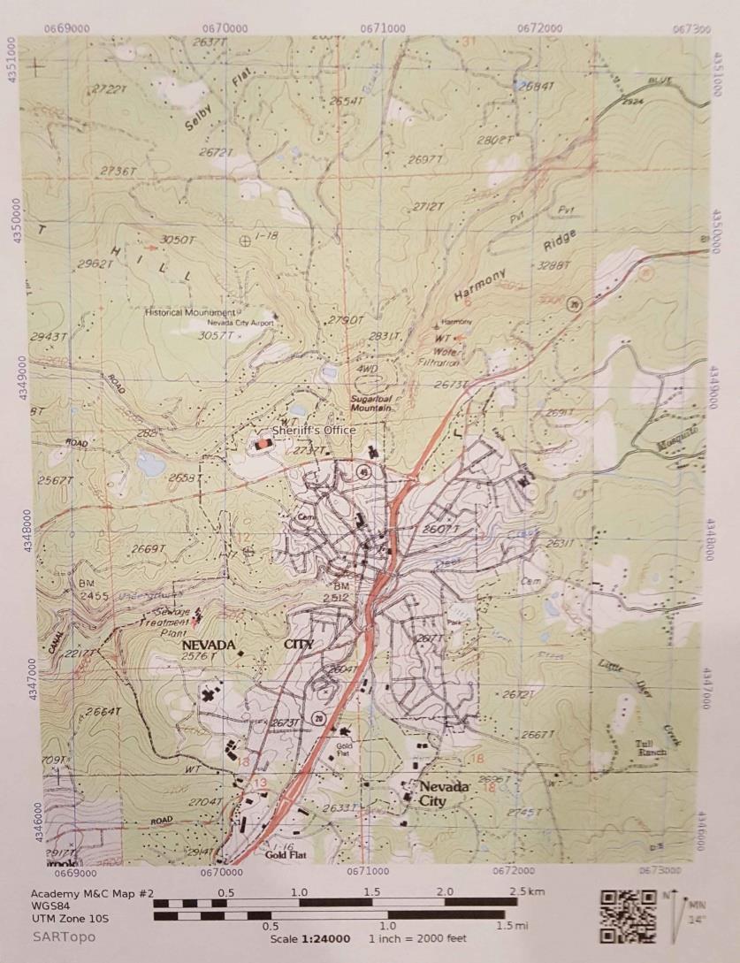
18 UTM The Sheriff s office is at: 10S E & N First number is easting (left to right), second is northing (bottom to top) Read right up Full coordinate gives 1 meter accuracy One UTM Grid is 1 km on each side about 250 acres in area
19 UTM

20 The Compass Magnetic needle: North is usually red Rotating bezel with orienteering arrow/lines and degree markings Boxing the needle Sight line and index mark Baseplate with inches and mm Magnetic Needle Compass Housing & Degree Dial Sighting Mirror Sight Line Index Mark Orienting Arrow Orienting Line Baseplate
21 The Compass The magnetic needle aligns itself with the strongest magnetic field Usually points to magnetic north Can be thrown off by metal, electrical fields (radios!), and local magnetic anomalies Be careful not to hold your compass too close to your radio!!


22 North? True North Geographic north pole Magnetic North Referenced to local magnetic field Magnetic pole is near Hudson Bay Changes over time Difference between true north and magnetic north is declination

23 Declination Declination in Nevada City is about 13.5 east (map is NOAA 2015 data)

24 Turn bezel to set North at index mark Align baseplate of compass to edge of map Box needle Map oriented to True North Orienting a Map
25 Take a Bearing Hold the compass out in front & level With mirror, hold at eye level, sight target in notch keeping black index line in center of compass Turn bezel to box the needle Read bearing at index mark Read Bearing Box Needle
26 Following a Heading Turn bezel to set desired heading at index mark Raise compass and turn yourself around until the needle is boxed Pick object on line, move ahead to object, repeat Can expect a 5-10% drift when following a heading Set Heading Turn around until needle is boxed
27 Read Bearing from Map Lay baseplate along line from start (X) to destination (Y) Direction of travel towards destination Rotate bezel until orienteering lines and arrow point true north Ignore the needle!! Read bearing at index mark (true bearing from X to Y) X Orienting Lines Y Map Bearing = 137 deg.

28 Read Bearing from Map

29 Plotting Bearing on Map Rotate bezel so that bearing is at index mark Lay baseplate on map with heel at starting point (X) Rotate entire compass until orienteering lines/arrow point true north Draw bearing line on map X Orienting Lines Y Map Bearing = 137 deg.

30 Plotting Bearing on Map
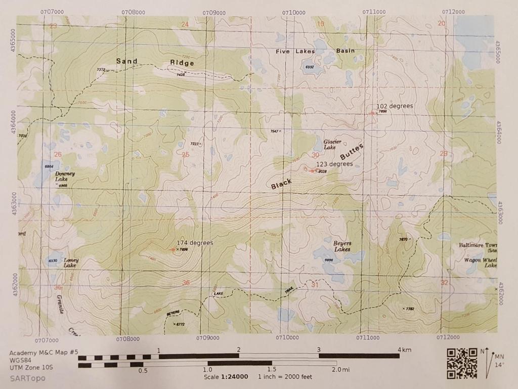
31 Triangulation Find prominent landmarks in real world and on map Determine bearing to one landmark Lay baseplate on map with direction of travel end on landmark Rotate entire compass until orienteering lines/arrow point true north Ignore the needle!! Draw line along baseplate Repeat for next landmark Location is roughly where lines intersect

32 Triangulation C Your Approx. Position B Map Bearing = 141 deg. A Map Bearing = 216 deg.
33 Triangulation

34 Triangulation
35 Route Finding Determining to safest way from one point on a map to another point on a map Used to get team from where you are to where you want to go Used to plan out how your going to search your area Being able to read a map is essential

36 Route Finding

37 Route Finding
38 Classroom Exercises Orienting maps Taking a bearing Following a heading Reading a bearing Plotting a bearing Triangulation Route Finding
Using Map and Compass Together
 Using Map and Compass Together In situations where you foresee a potential evacuation on foot, where there are no roads, and no indication as to the direction of travel (i.e., road signs), it is recommended
Compass Basics. Quick Map Basics Review For Compass Use
 Compass Basics Quick Map Basics Review For Compass Use A topographic map tells you where things are and how to get to them, whether you're hiking, biking, hunting, fishing, or just interested in the world
Topographic Maps and Landforms Geology Lab
 Topographic Maps and Landforms Geology Lab Ray Rector: Instructor Today s Lab Activities 1) Discussion of Last Week s Lab 2) Lecture on Topo Maps and Elevation Contours 3) Construct Topographic Maps and
B. Topographic maps are also called. contour maps
 Topographic Maps Introduction A. Topographic maps are essential tools in geologic and engineering studies because they show the configuration of Earth's surface in remarkable detail and permit one to measure
Topographic Map Series:
 DEFINITION OF A MAP A MAP IS A GEOGRAPHIC PREPRESENTATION OF A PORTION OF THE EARTH S SURFACE DRAWN TO SCALE, AS SEEN FROM ABOVE. IT S USES COLORS, SYMBOLS AND LABELS TO REPRESENT FEATURES FOUND ON THE
USING THE MILITARY LENSATIC COMPASS
 USING THE MILITARY LENSATIC COMPASS WARNING This presentation is intended as a quick summary, and not a comprehensive resource. If you want to learn Land Navigation in detail, either buy a book; or get
Butte County Fire Department
 Butte County Fire Department Basic Land Navigation Verification Sheet I verify that Print Supervisor s name has completed the Print Employee s name Basic Land Navigation self study guide on. Date Attached
USING THE MILITARY LENSATIC COMPASS
 USING THE MILITARY LENSATIC COMPASS WARNING This presentation is intended as a quick summary, and not a comprehensive resource. If you want to learn Land Navigation in detail, either buy a book; or get
Orienteering Maps & Map Reading Latitude and Longitude Scale
 Orienteering Maps & Map Reading A map is a two-dimensional representation of the three-dimensional world you'll be hiking in. All maps will have some basic features in common and map reading is all about
Chapter 3 Models of the Earth. 3.1 Finding Locations on the Earth. 3.1 Objectives
 Chapter 3 Models of the Earth 3.1 Finding Locations on the Earth 3.1 Objectives Explain latitude and longitude. How can latitude and longitude be used to find locations on Earth? How can a magnetic compass
What is a map? A Map is a two or three-dimensional model or representation of the Earth s surface. 2-Dimensional map
 What is a map? A Map is a two or three-dimensional model or representation of the Earth s surface. 2-Dimensional map What is a Map Projection? Planar Projection Projection A Projection is a mathematical
The Tacoma Mountaineers Wilderness Navigation
 The Tacoma Mountaineers Wilderness Navigation Navigation Fundamentals Navigation in mountainous terrain and wilderness areas requires a set of skills, of which using a map and compass is only one part.
Navigating for Scouts A Self-teaching Guide to Navigation with Map and Compass
 Don Burgess, November 2003 Materials topographic maps Navigating for Scouts A Self-teaching Guide to Navigation with Map and Compass metric ruler orienteering compass 30 M/5 Hamilton-Burlington 41 I/13
King County Explorer Search and Rescue. Course B Map & Compass
 King County Explorer Search and Rescue Course B Map & Compass Disclaimer The intent of this presentation is to provide a basic overview of maps, compasses, and location finding. It is not meant to be a
Map Reading & Compass Use
 Spring 2013 Kestrel Land Trust Page 2 / 10 Contents Map Basics... 3 Map Types... 3 Terrain Association... 4 Estimating Distance: Pacing... 4 Contour Lines... 5 Navigating with a Compass... 6 Compass Types...
Basic Map Skills for the Outdoors
 Geography 80-20 80% of what there is to know, for 20% of the sweat Basic Map Skills for the Outdoors Map Scale Map source: US Geological Survey Four ways to indicate map scale: Representative fraction
Butte County Fire Department
 Butte County Fire Department Basic Land Navigation Verification Sheet I verify that Print Supervisor's name Print Employee's name has completed the Basic Land Navigation self study guide on Date Attached
Map and Compass Skills
 Map and Compass Skills Grade levels: 5-12 In a Nutshell Given a map and compass, students will be able to find a location on the map, chart a course to that location with the compass, and find that location
AS 410 Land Navigation. Chpt 4-1
 AS 410 Land Navigation Chpt 4-1 Overview Types of Maps Map Legends / Scales Latitude and Longitude Orienteering Why? Why important to learn how to read a compass and map? No cell phone coverage Mountain
OA Guide to Map & Compass. The Backpacker's Field Manual by Rick Curtis
 OA Guide to Map & Compass part of The Backpacker's Field Manual by Rick Curtis Published by Random House 1998 This material is taken from Chapter 6 - Wilderness Travel from The Backpackers Field Manual
OA Guide to Map & Compass - Part 1
 OA Guide to Map and Compass - Part 1 OA Guide to Map & Compass - Part 1 part of The Backpacker's Field Manual by Rick Curtis published by Random House 1998 Buy it now at Amazon.com This material is taken
California Cadet Corps Curriculum on Maps and Navigation. Map Reading LEADERS KNOW THE WAY
 California Cadet Corps Curriculum on Maps and Navigation Map Reading LEADERS KNOW THE WAY 5/22/2017 Map Reading Agenda A1. Introduction to Maps A2. Topographical Map Basics A3. Elevation and Terrain Features
APPENDIX A GLOSSARY. Appendix A.1
 APPENDIX A GLOSSARY Appendix A.1 Appendix A.2 Back Bearing A back bearing is measured from the object to your position. It is the exact opposite of a direct bearing. Base Line An imaginary line on the
Basic Land Navigation. Clark County Sheriff Core Comp Rev. # Land Navigation
 Basic Land Navigation Clark County Sheriff Core Comp Rev. # 2018 1 Land Navigation Requirement Through written evaluation the applicant will demonstrate knowledge of land navigation involved in Search
Chapter 3 SECTION 1 OBJECTIVES
 Chapter 3 SECTION 1 OBJECTIVES Distinguish between latitude and longitude and locate coordinates on maps. Explain how latitude and longitude can be used to locate places on Earth s surface. Explain the
USING THE MILITARY LENSATIC COMPASS
 USING THE MILITARY LENSATIC COMPASS WARNING This presentation is intended as a quick summary, and not a comprehensive resource. If you want to learn Land Navigation in detail, either buy a book; or get
Earth Science Regents Reading Topographic Maps
 Earth Science Regents Reading Topographic Maps Name Period Quick Tutorial on Degrees, Minutes, and Seconds of Latitude and Longitude A degree of latitude on the surface of the earth is about 70 miles long.
Trail Life USA High Adventure Training Land Navigation Module. Dennis Conte
 Trail Life USA High Adventure Training Land Navigation Module Dennis Conte Navigating With GPS and a MAP Let s Talk about your GPS Hand Held Tool. Is a GPS Hand Held the magic bullet? Can it solve all
Red Star Navigation. Bearings:
 Red Star Navigation Bearings: The main focus in Red Star Navigation is how to use a compass and in particular compass bearings. It is important for cadets to describe bearings as this will assist them
How to Use a Compass with a USGS Topographic Map
 How to Use a Compass with a USGS Topographic Map METHOD #1: (these directions assume your orienting arrow lines up with the North indicator on your compass dial, meaning the compass has not been adjusted
BUSH NAV BUSH NAV DAY Navigation for Bush Navigation Day. November. WhitehorseD AY. Section 1 Registration, Maps & Checkpoints
 BUSH DAY Navigation for Bush Navigation Day Robert Kirwan, Nunawading SES W NW N NE E If you have little or no bush navigation experience then you will have been teamed up with members that have that experience
Classroom Outing
 Classroom Outing Government Of Canada Government Of BC, Printed by Gotrekkers: http://www.gotrekkers.com/bc-topo-20k-britishcolumbia-topographic-map/ Gemtrek Mark Klassen et al John Baldwin Chrismar
Akuni Adventures GPS Navigation Course. Welcome
 Akuni Adventures GPS Navigation Course Welcome 1 GPS Navigation Course Instructor: Joe Bourgeois joe@akuni.com 2 Waiver Please take a moment to read and sign your waiver. Thank You 3 Maps: Agenda Margin
Chapter 3 Geographic Location Systems
 Chapter 3 Geographic Location Systems In this chapter you will learn about: Latitude and longitude Universal Transverse Mercator (UTM) U.S. Public Land Survey Other geographic location systems Geographic
Advanced Vectors. Table of Contents
 Advanced Vectors Table of Contents I. Location and Distance on Earth 2 Introduction Determining Latitude Latitude and the North Star Determining Longitude Longitude and Time Using Earth's Grid System Google
The ABC's of Compass and Map STUDENT WORKBOOK
 The ABC's of Compass and Map STUDENT WORKBOOK 1 EXERCISE 1: Compass Part Identification Directions: Match the terms below with the correct parts on the compass diagram. NOTES: A. Azimuth Ring B. Compass
From Science Olympiad Student Center
 1 of 10 3/5/13 8:18 AM Forums Wiki Test Exchange Image Gallery Score Tracker Road Scholar From Science Olympiad Student Center In Road Scholar, Forum Threads Tests There are no images available for this
REVISION: MAPWORK 18 SEPTEMBER 2014
 REVISION: MAPWORK 18 SEPTEMBER 2014 Lesson Description In this lesson we revise: Various mapwork calculations Summary Relative Position Bearing is the angular (angle) distance between two points True Bearing
ANSWER SHEET PART 1 BASIC LAND NAVIGATION
 ANSWER SHEET PART 1 BASIC LAND NAVIGATION 1. Knowing these four basic skills, it is impossible to be totally lost; what are they? a. Track Present Location / Determine Distance / Sense of Direction / How
CHAPTER EXIT CHAPTER. Models of Earth. 3.1 Modeling the Planet. 3.2 Mapmaking and Technology. 3.3 Topographic Maps CHAPTER OUTLINE
 EXIT CHAPTER.1 Modeling the Planet.2 Mapmaking and Technology. Topographic Maps CHAPTER OUTLINE CHAPTER.1 Modeling the Planet A flat of Earth is a convenient tool, but it can distort the shape, distance,
Charts and Chart Work with Poole Sailing
 with Poole Sailing Nautical charts are a mine of information but they need to be up to date. Corrections to charts are published by the Hydrographic Office monthly as Notices to Mariners both in print
UNIT 1C. USING TOPOGRAPHIC MAPS WHERE IN THE WORLD... ARE YOU?
 UNIT 1C. USING TOPOGRAPHIC MAPS WHERE IN THE WORLD... ARE YOU? TIME 60-90 minutes LEVEL All BENCHMARKS Next Generation Science Standards MS-LS1.D Science & Engineering Practices Developing and Using Models
Road Scholar. Coaches Clinic
 Coaches Clinic Test Format Review of Individual Test Elements Items to Bring Tips Links General Test Format: Storyline Test Navigation Elements Identification of Landmarks, features, etc. Aerial/Satellite
Topographic Maps Self-Instruction Lab (2016 edition) Geology 100 David Harbor s Section. 12 inches x 1 mile
 Geology 100 David Harbor s Section. 12 inches x 1 mile") Topographic Maps Name Self-Instruction Lab (2016 edition) Geology 100 David Harbor s Section Topographic maps are an important aid for a geologist, but maps are also useful for hikers, bicyclists, and
Topographic Maps Name Self-Instruction Lab (2016 edition) Geology 100 David Harbor s Section Topographic maps are an important aid for a geologist, but maps are also useful for hikers, bicyclists, and
GCSAR Navigation -- Maps
 GCSAR Navigation -- Maps From the GCSAR Certification Standards Identify and explain all the border information on a topographic map. Identify and explain the following aspects of maps: index and intermediate
Basic Land Navigation
 A Publication of the National Wildfire Coordinating Group National Interagency Incident Management System Basic Land Navigation PMS 475 June 2007 NFES 2865 JUNE 2007 NFES 2865 Sponsored for NWCG publication
Coach Answers Part 2 Zombie 17 COACH ANSWERS (Questions and answers with explanations) Part 2
 Part 2") Zombie 17 COACH ANSWERS (Questions and answers with explanations) Part 2 44. The Brain Building looks fairly new. Based on the map, what is the most recent year in which it could have been constructed?
Zombie 17 COACH ANSWERS (Questions and answers with explanations) Part 2 44. The Brain Building looks fairly new. Based on the map, what is the most recent year in which it could have been constructed?
Land Navigation Table of Contents
 Land Navigation Table of Contents Preparatory Notes to Instructor... 1 Session Notes... 5 Learning Activity: Grid Reference Four Figure... 7 Learning Activity: Grid Reference Six Figure... 8 Learning Activity:
HWA CHONG INSTITUTION NATIONAL POLICE CADET CORPS TOPOGRAPHY AND ORIENTEERING. Topography and Orienteering
 Topography and Orienteering 1. Introduction Orienteering is about using a topographic map and compass to find points in the landscape. It is fun and challenging, as one would need to take reference to
56H. This system allows definition of points on the Earth s surface to within 100 meters. Page 20. Navigation Systems Basics of Maps
 Grid References Many maps are provided with the standard grid overlaying them. This provides a simple and accurate method for finding features on the map. It is a network of intersecting parallel lines
LAND NAVIGATION 2-1. DEFINITION
 LAND NAVIGATION MAPS Cartography is the art and science of expressing the known physical features of the earth graphically by maps and charts. No one knows who drew, molded, laced together, or scratched
LESSON 2: INTRODUCTION TO TOPOGRAPHICAL MAPS
 LESSON 2: INTRODUCTION TO TOPOGRAPHICAL MAPS Finding your way if you become separated from a group. PURPOSE This lesson presents an overview of topographic maps. It describes their characteristics and
Adventure Racing Navigation Supplies. Table Top Adventure Race & Navigation Challenge. Preview
 Adventure Racing Navigation Supplies Table Top Adventure Race & Navigation Challenge 12 Navigation Challenges for Map and Compass Navigation Volume 1. June 2009 Presented by AR Navigation Supplies, Inc.
Basic Map & GPS Skills. How to read a topographic map, use a compass, and determine GPS locations on a map
 Basic Map & GPS Skills How to read a topographic map, use a compass, and determine GPS locations on a map Table of Contents This booklet covers what a topographic map (topo map) is, how to use a map, and
Basic Land Navigation
 A Publication of the National Wildfire Coordinating Group National Interagency Incident Management System Basic Land Navigation PMS 475 June 2007 NFES 2865 Basic Land Navigation JUNE 2007 NFES 2865 Sponsored
What is a map? Understanding your map needs
 What is a map? A map is simply a drawing or picture of a landscape or location. Maps usually show the landscape as it would be seen from above, looking directly down. As well as showing the landscape of
GPS Measurement Protocol
 GPS Measurement Protocol Purpose To determine the latitude, longitude, and elevation of your school and of all your GLOBE sites Overview The GPS receiver will be used to determine the latitude, longitude
Test Bank Chapter 2: Representations of Earth
 Multiple Choice Test Bank Chapter 2: Representations of Earth 1. A rhumb line on a Mercator projection is a line of. a. true size b. true shape c. true compass bearing d. true location 2. Maximum longitude
1. Identify the Earth motion that provides the basis for our system of local time and time zones.
 Base your answers to questions 1 through 4 on the map below and on your knowledge of Earth science. The map shows the four time zones and some latitude and longitude lines across the continental United
How to Use a Compass
 How to Use a Compass The compass consists of a magnetized metal needle that floats on a pivot point. The needle orients to the magnetic field lines of the earth. The basic orienteering compass is composed
Activities: Map and Compass
 Activities: Map and Compass Determining General Directions Modified with permission from Outdoor Living Skills Series: Map and Compass, Missouri Department of Conservation Overview: Students use the sun
NAME DATE TOPOGRAPHIC MAPS. Activity 1: Topographic Map Investigation I: More Than a Road Map
 NAME DATE PARTNER(S) TOPOGRAPHIC MAPS Now you have seen how topographic maps can be generated to present the elevation of a terrain. Let s look at some topographic maps and learn how to interpret them.
Date: UNI. world. *Dedicated to
 Name: Date: UNI IT THREE 2D and 3D model s of the natural world *Dedicated to Name: Date: ABSTRACT T AND RATIONALE A topographic map is a type of map that depicts the detail and quantitative representation
A-CR-CCP-803/PF-001 CHAPTER 18 PO 390 NAVIGATE A ROUTE USING A MAP AND COMPASS
 CHAPTER 18 PO 390 NAVIGATE A ROUTE USING A MAP AND COMPASS ROYAL CANADIAN AIR CADETS PROFICIENCY LEVEL THREE INSTRUCTIONAL GUIDE SECTION 1 EO M390.01 IDENTIFY PARTS OF THE COMPASS Total Time: 30 min PREPARATION
Chapter 1 Overview of Maps
 Chapter 1 Overview of Maps In this chapter you will learn about: Key points when working with maps General types of maps Incident specific maps Map legend and symbols Map sources A map is a navigational
PART 2 INTERMEDIATE LAND NAVIGATION
 PART 2 INTERMEDIATE LAND NAVIGATION USING THE MILITARY LENSATIC COMPASS WARNING This presentation is intended as a quick summary, and not a comprehensive resource. If you want to learn Land Navigation
Lesson 3: Locating Plots on the Ground
 Review and Introduction Lesson 3: Locating Plots on the Ground So far, you have identified individual stands in the forest, learned about plot sampling, and marked locations on a map of where your inventory
Mapping Earth s Surface Chapter 2 Section 3
 Mapping Earth s Surface Chapter 2 Section 3 Day 1 Objective I will understand maps can be used to find locations on Earth and to represent information about features on Earth s Surface I will understand
Laboratory Exercise #2 Introduction to Quadrangle Maps
 page - 1 Laboratory Exercise #2 Introduction to Quadrangle Maps A. Introduction to Quadrangle Maps The United States Geological Survey has developed a nationwide series of quadrangle maps that cover small
1. Label a few examples of lines of latitude and lines of longitude on the globe above left.
 Oceanography 2 Location, Direction, and Distance on Nautical Charts Please read Appendix III in the textbook for reference. Learning Objectives for the first nautical chart Lab 1. Use the latitude-longitude
COORDINATE SYSTEMS: LOCATING YOURSELF ON A SPHERE
 NAME DATE PARTNER(S) COORDINATE SYSTEMS: LOCATING YOURSELF ON A SPHERE Activity 1: Getting Your Bearings 1. Close your eyes and point to the north. Did you point up? Why or why not? Up is the #1 answer.
Basic Field Instruments Field Orientation, Basic Navigation ESRM 304
 Basic Field Instruments Field Orientation, Basic Navigation ESRM 304 Three Basic Navigation Measurements Direction Distance Elevation (or change in it) 2 Compass for Direction Looking from point to point,
Map Skills Unit. Note taking unit
 Map Skills Unit Note taking unit Introduction To learn about the Earth, we are going to learn about two geographic tools you can use.globes and maps. Globe A globe is a round model of the planet Earth
Road Scholar. Williamette Valley Invitational Practice Tournament
 Road Scholar Williamette Valley Invitational Practice Tournament Rules for this Event As you complete this event, enter your answers on the online data sheet. You may click "submit" when done and quietly
Lab Topographic Maps. Name: Partner: Purpose. Background Information
 Lab Topographic Maps Name: Partner: Purpose The purpose of this lab is to familiarize you with graphic representations of the Earth s surface primarily maps. Simple line maps show the spatial relationship
Laboratory Exercise #2 Introduction to Quadrangle Maps
 page - Laboratory Exercise #2 Introduction to Quadrangle Maps A. Introduction to Quadrangle Maps The United States Geological Survey has developed a nationwide series of quadrangle maps that cover small
About places and/or important events Landmarks Maps How the land is, hills or flat or mountain range Connected to maps World Different countries
 What do you think you know about geography? About places and/or important events Landmarks Maps How the land is, hills or flat or mountain range Connected to maps World Different countries What do you
Geography Progression
 Geography Progression This document aims to track expectations for History within George Grenville Academy. What the National Curriculum says: KS1: Locational Knowledge: Name and locate the world s 7 continents
What Do You See? FOR 274: Forest Measurements and Inventory. Area Determination: Frequency and Cover
 What Do You See? Message of the Day: Many options exist to determine the size, area, or extent of a feature on a landscape FOR 274: Forest Measurements and Inventory Lecture 7: Measures of Land Area Frequency
Background Information
 Oceanography LAB #1: Marine Charts and Navigation Background Information Latitude and Longitude A coordinate is an address a means of designating location. Most coordinate systems involve a network of
Map Reading Guide How to use Topographic Maps
 Map Reading Guide How to use Topographic Maps Geoscience Australia Cnr Jerrabomberra Avenue & Hindmarsh Drive Symonston ACT 2609 GPO Box 378 Canberra ACT 2601 Freecall (within Australia) 1800 800 173 Email:
Mazamas Mt. Tabor Map and Compass Training Course
 Mazamas Mt. Tabor Map and Compass Training Course To do the course, you ll need: 1. Printout of the course map (at web link at bottom of page) 2. Printout of the course notes (you re reading them =^) 3.
Navigation. Longitude and Latitude Foundations of Navigation. MTPs:
 Navigation 3.01 Foundations of Navigation References: FTGU pages 177-178, 184-190 Transport Canada Study and Reference Guide Glider Pilot Canada Flight Training Manual Pilot Navigation http://en.wikipedia.org/wiki/transverse_mercator_projection#spherical_transverse_mercator
Your Silva Ranger Compass is a precision instrument made by experienced
 RANGER COMPASS model: 515 A PRECISION INSRUMEN DESIGNED FOR PROFESSIONAL USE. INSRUCION MANUAL Your Silva Ranger Compass is a precision instrument made by experienced specialists in this field; it is the
Complete Geography Overview: Year 1 to Year 6
 Option 1 Complete Geography Overview: Year 1 to Year 6 Autumn Term Spring Term Summer Term Year 1 Where do I live? Around the World The Four Seasons Year 2 At the Farm Let s go on Safari My World and Me
Relative and Absolute Directions
 Relative and Absolute Directions Purpose Learning about latitude and longitude Developing math skills Overview Students begin by asking the simple question: Where Am I? Then they learn about the magnetic
Topo Map Tidbits. Adapted from: An original Creek Connections activity. Creek Connections, Box 10, Allegheny College, Meadville, Pennsylvania, 16335
 Topo Map Tidbits Adapted from: An original Creek Connections activity. Creek Connections, Box 10, Allegheny College, Meadville, Pennsylvania, 16335 Introduction to Topographic Maps Grade Level: Basic Duration:
GUIDE MAP READING TOPOGRAPHIC MAPS HOW TO USE. Scrivener Building, Dunlop Court Fern Hill Park, Bruce ACT PO Box 2, Belconnen ACT 2616
 MAP READING GUIDE HOW TO USE TOPOGRAPHIC MAPS Scrivener Building, Dunlop Court Fern Hill Park, Bruce ACT 2617 PO Box 2, Belconnen ACT 2616 FREECALL 1800 800 173 within Australia Tel (02) 6201 4300 Fax
2 Mapping Earth Reading Essentials. 2. Contrast What is the difference between a map view and a profile view?
 Mapping Earth Maps What do you think? Read the three statements below and decide whether you agree or disagree with them. Place an A in the Before column if you agree with the statement or a D if you disagree.
ROYAL CANADIAN AIR CADETS PROFICIENCY LEVEL FOUR INSTRUCTIONAL GUIDE SECTION 4 EO C USE A VISUAL FLIGHT RULES (VFR) NAVIGATION CHART (VNC)
 NAVIGATION CHART (VNC)") ROYAL CANADIAN AIR CADETS PROFICIENCY LEVEL FOUR INSTRUCTIONAL GUIDE SECTION 4 EO C437.02 USE A VISUAL FLIGHT RULES (VFR) NAVIGATION CHART (VNC) Total Time: 60 min PREPARATION PRE-LESSON INSTRUCTIONS Resources
ROYAL CANADIAN AIR CADETS PROFICIENCY LEVEL FOUR INSTRUCTIONAL GUIDE SECTION 4 EO C437.02 USE A VISUAL FLIGHT RULES (VFR) NAVIGATION CHART (VNC) Total Time: 60 min PREPARATION PRE-LESSON INSTRUCTIONS Resources
Geology 101 Lab Worksheet: Topographic Maps
 Geology 101 Lab Worksheet: Topographic Maps Name: Refer to the Topographic Maps Lab for the information you need to complete this worksheet (http://commons.wvc.edu/rdawes/g101ocl/labs/topomapslab.html).
New National Curriculum Geography Skills Planning KS1
 New National Curriculum Geography Skills Planning KS1 Enquiry Question Objective-essential knowledge skills or understanding Locational Knowledge Standards /Success Criteria Lesson progression over half
Map Reading: Grades 4 & 5
 Map Reading: Grades 4 & 5 Grades: 4,5 Team Size: 1-2 competitors Duration: 25 minutes Supervisors: Sriram Garapati, Rebecca Neill-Totsuka Summary Description Students will solve a mystery using different
NR402 GIS Applications in Natural Resources Lesson 4 Map Projections
 NR402 GIS Applications in Natural Resources Lesson 4 Map Projections From http://www.or.blm.gov/gis/ 1 Geographic coordinates Coordinates are expressed as Latitude and Longitude in Degrees, Minutes, Seconds
FM Map Reading and Land Navigation
 FM 3-25.26 Map Reading and Land Navigation CHAPTER 4 GRIDS This chapter covers how to determine and report positions on the ground in terms of their locations on a map. Knowing where you are (position
In order to be adequately prepared for a test on this topic you should be able to:-
 Topic 2: MAPPING In order to be adequately prepared for a test on this topic you should be able to:- 1. Find and also provide both FOUR and SIX figure Area and Grid References 2. Calculate distances both
GeoMag USING GEOMAG 2 UTM COORDINATE SYSTEM 4 GEODETIC DATUMS AND ELLIPSOIDS 11 A BRIEF INTRODUCTION TO GEOMAGNETISM 14 EARTH MAGNETIC FIELD MAPS 16
 GeoMag USING GEOMAG 2 UTM COORDINATE SYSTEM 4 GEODETIC DATUMS AND ELLIPSOIDS 11 A BRIEF INTRODUCTION TO GEOMAGNETISM 14 EARTH MAGNETIC FIELD MAPS 16 ABOUT GEOMAG 18 1 Using GeoMag GeoMag is a very simple
Topographic Maps: Background
 Topographic Maps: Background Introduction From Dr. Terry Swanson, University of Washington, ESS 101 Lab, Geologic Techniques, and Dr. David Kendrick, Hobart and William Smith Colleges, Geneva, NY Geoscientists
Geography and Earth Science. Unit 5
 Geography and Earth Science Unit 5 Chapter 1 Map Skills Lesson 2 Introduction to Maps Key Terms What You Will Learn to Do Use map reading skills bar scale contrast elevation intermittent landforms legend
Navigation and Communication AS January Sara Mollie Cohen Head Engineer, Department of Arctic Geology
 Navigation and Communication AS101 07-11 January 2019 Sara Mollie Cohen Head Engineer, Department of Arctic Geology Course Objectives Navigation Maps, Coordinate Sysems GPS, TopoSvalbard, Weather Communication