Chapter 3 Models of the Earth. 3.1 Finding Locations on the Earth. 3.1 Objectives
|
|
|
- Ashlyn Pope
- 6 years ago
- Views:
Transcription
1 Chapter 3 Models of the Earth 3.1 Finding Locations on the Earth 3.1 Objectives Explain latitude and longitude. How can latitude and longitude be used to find locations on Earth? How can a magnetic compass be used to find directions on Earth. 1


2 Latitude & Longitude Latitude One set of circles describes positions north and south of the equator. These circles are known as parallels, and they express latitude. parallel any circle that runs east and west around Earth and that is parallel to the equator; a line of latitude latitude the angular distance north or south from the equator; expressed in degrees The diagram below shows Earth s parallels. 2
 ) of latitude equals 1.85 km.")
3 Measuring Latitude Degrees of Latitude Latitude is measured in degrees, and the equator is 0 0 latitude. The latitude of both the North Pole and the South Pole is 90. In actual distance, 1 1 latitude equals about 111 km. Minutes and Seconds Each degree of latitude consists of 60 equal parts, called minutes.. One minute (symbol: ) ) of latitude equals 1.85 km. In turn, each minute is divided into 60 equal parts, called seconds (symbol: ). Longitude East-west locations are established by using meridians. meridian any semicircle that runs north and south around Earth from the geographic North Pole to the geographic South Pole; a line of longitude longitude the angular distance east or west from the prime meridian; expressed in degrees The diagram below shows Earth s meridians. 3

4 Measuring Longitude Degrees of Longitude The meridian that passes through Greenwich, England is called the prime meridian.. This meridian represents 0 0 longitude. The meridian opposite the prime meridian, halfway around the world, is labeled 180,, and is called the International Date Line. Distance Between Meridians The distance covered by a degree of longitude depends on where the degree is measured. The distance measured by a degree of longitude decreases as you move from the equator toward the poles. Great Circles A A great circle is any circle that divides the globe into halves, or marks the circumference of the globe. Any circle formed by two meridians of longitude that are directly across the globe from each other is a great circle. The equator is the only line of latitude that is a great circle. The route along a great circle is the shortest distance between two points on a sphere. As a result, great circles are commonly used in navigation, such as for air and sea routes. The diagram below shows what a great circle is. 4

5 Finding Direction One way to find direction on Earth is to use a magnetic compass. A magnetic compass can indicate direction because Earth has magnetic properties as if a powerful bar-shaped magnet were buried at Earth s s center at an angle to Earth s axis of rotation. The areas on Earth s s surface just above where the poles of the imaginary magnet would be are called the geomagnetic poles. The geomagnetic poles and the geographic poles are located in different places. Magnetic Declination The angle between the direction of the geographic pole and the direction in which the compass needle points is called magnetic declination. In the Northern Hemisphere, magnetic declination is measured in degrees east or west of the geographic North Pole. By using magnetic declination, a person can use a compass to determine geographic north for any place on Earth. true north is the direction of the geographic North Pole. Magnetic Declination 5
6 Global Positioning System Another way people can find their location on Earth is by using the global positioning system, or GPS. GPS is a satellite navigation system that is based on a global network of 24 satellites that transmit radio signals to Earth s s surface. A A GPS receiver held by a person on the ground receives signals from three satellites to calculate the latitude, longitude, and altitude of the receiver on Earth. 3.2 Mapping the Earth s Surface 3.2 Objectives What are the characteristics AND uses of 3 types of map projections? What is scale,, and how can scale be used to find distance on a map? 6
7 Maps Globes are too small to show details of Earth s surface, such as streams and highways, so a great variety of maps have been developed for studying and displaying detailed information about Earth. The science of making maps is called cartography.. Scientists who make maps are called cartographers. Because a map is a flat representation of a globe, flat maps have distortion. Distortion = errors in size, distance, and/or direction. Map Projections A map is a flat representation of Earth s s curved surface. Transferring a curved surface to a flat map results in a distorted image of the curved surface. An area shown on a map may be distorted in size, shape, distance, or direction. Over the years, cartographers have developed several ways to transfer the curved surface of Earth onto flat maps. These methods are called map projections. map projection a flat map that represents a spherical surface No map projection is entirely accurate, but each kind of projection has advantages and disadvantages. Mercator Projection If you wrapped a cylinder of paper around a lighted globe and traced the outlines of continents, oceans, parallels, and meridians, a Mercator projection would result. A Mercator projection is accurate near the equator but distorts distances and sizes near the poles. One advantage to Mercator projections is that parallels and meridians form a grid, which makes locating positions easier. On a cylindrical projection, shapes of small areas are usually well preserved. 7


8 Mercator Projection Gnomonic Projection A projection made by placing a sheet of paper against a globe such that the paper touches the globe at only one point is called an Gnomonic projection. On an Gnomonic projection, little distortion occurs at a the point of contact, but the unequal spacing between parallels causes a distortion in both direction and distance that increases as distance from the point of contact increases. One advantage of Gnomonic projections is that on these maps, great circles appear as straight lines.. Thus, Gnomonic projections are useful for plotting navigational paths. Gnomonic Projection 8


9 Conic Projection A projection made by placing a paper cone over a lighted globe so that the axis of the cone aligns with the axis of the globe is known as a conic projection. Areas near the parallel where the cone and the globe are in contact are distorted least. A series of conic projections can be used to increase accuracy by mapping a number of neighboring areas and fitting the adjoining areas together to make a polyconic projection. On a polyconic projection, the relative sizes and shapes of small areas on the map are nearly the same as those on the globe. Conic Projection Reading a Map 9
10 Reading a Map - Symbols Symbols are commonly used on maps to represent features such as cities, highways, rivers, and other points of interest. Symbols may resemble the features that they represent, or they may be more abstract. Symbols are commonly explained in a legend. legend a list of map symbols and their meanings Reading a Map - Direction Maps are commonly drawn with north at the top, east at the right, west at the left, and south at the bottom. Some maps use parallels of latitude and meridians of longitude to indicate direction and location. Many maps also include a compass rose,, which is a symbol that indicates the cardinal directions (north, east, south, and west), or an arrow that indicates north. Map Scale scale the relationship between the distance shown on a map and the actual distance Map scales are commonly expressed as graphic scales, fractional scales,, or verbal scales. A graphic scale is a printed line that has markings that represent units of measure, such as meters or kilometers. A fractional scale is a ratio that indicates how distance on Earth relates to distance on the map. A verbal scale expresses scale in sentence form. 10
11 3.3 Topographic Maps 3.3 Objectives How can elevation and topography be shown on a map? How do you interpret (read) a topographic map? Topographic Maps One of the most widely used maps is called a topographic map, which shows the surface features of Earth. topography the size and shape of the land surface features of a region elevation the height of an object above sea level Advantages of Topographic Maps Topographic maps provide more detailed information about the surface of Earth than either drawings or political maps. 11

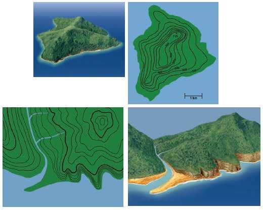
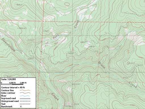
12 Interpreting a Topographic Map Symbols are used to show certain features on topographic maps. Symbol color indicates the type of feature. Constructed features, such as buildings, are shown in black. Highways are shown in red. Bodies of water are colored blue, and forested areas are colored green. Contour lines are brown or black. Elevation on Topographic Maps On topographic maps, elevation is shown by using contour lines. contour line a line that connects points of equal elevation on a map The difference in elevation between one contour line and the next is called the contour interval. The contour interval is selected based on the relief of the area being mapped. relief the difference between the highest and lowest elevations in a given area Every fifth contour line is darker than the four lines one either side of it. This index contour makes reading elevation easier. 12

13 Index Contour, Contour Interval, and Relief Landforms on Topographic Maps The spacing and direction of contour lines indicate the shapes of the landforms represented on a topographic map. Closely spaced contour lines indicate that the slope is steep. Widely spaced contour lines indicate that the land is relatively level. Landforms on Topographic Maps A A contour line that bends to form a V shape indicates a valley. The bend in the V points toward the higher end of the valley; this V points upstream, or in the direction from which the water flows, if there is a stream. Contour lines that form closed loops indicate a hilltop or a depression. Closed loops that have short straight lines perpendicular to the inside of the loop indicate a depression. 13
14 14
CHAPTER EXIT CHAPTER. Models of Earth. 3.1 Modeling the Planet. 3.2 Mapmaking and Technology. 3.3 Topographic Maps CHAPTER OUTLINE
 EXIT CHAPTER.1 Modeling the Planet.2 Mapmaking and Technology. Topographic Maps CHAPTER OUTLINE CHAPTER.1 Modeling the Planet A flat of Earth is a convenient tool, but it can distort the shape, distance,
What is a map? A Map is a two or three-dimensional model or representation of the Earth s surface. 2-Dimensional map
 What is a map? A Map is a two or three-dimensional model or representation of the Earth s surface. 2-Dimensional map What is a Map Projection? Planar Projection Projection A Projection is a mathematical
Introduction to Geography
 Introduction to Geography ropic of Cancer 3½ N Arctic Circle 90 N Prime Meridian 0 Arctic Ocean Mississippi R. Appalachian Mts. Europe Rocky Mountains N. America Atlantic Gulf of Ocean Mexico Caribbean
Mapping Our World Chapter 2
 Mapping Our World Chapter 2 Section 2.1: Latitude and Longitude Maps are flat models of threedimensional objects. For thousands of years people have used maps to define borders and to find places. With
Introduction to Geography
 Introduction to Geography What is geography? Geography comes from the Greek word Geographia. Geo means earth and graphia means to describe or chart. Geographers study the earth in relation to space and
Name Class Date. For each pair of terms, explain how the meanings of the terms differ.
 Skills Worksheet Chapter Review USING KEY TERMS For each pair of terms, explain how the meanings of the terms differ. 1. true north and magnetic north 2. latitude and longitude 3. equator and prime meridian
Chapter 3 SECTION 1 OBJECTIVES
 Chapter 3 SECTION 1 OBJECTIVES Distinguish between latitude and longitude and locate coordinates on maps. Explain how latitude and longitude can be used to locate places on Earth s surface. Explain the
Ch2&3 Test. Multiple Choice Identify the choice that best completes the statement or answers the question.
 Ch2&3 Test Multiple Choice Identify the choice that best completes the statement or answers the question. 1. Earth s circumference is about 40,000 km, and its shape is a. an oval. c. a perfect sphere.
APPENDIX A GLOSSARY. Appendix A.1
 APPENDIX A GLOSSARY Appendix A.1 Appendix A.2 Back Bearing A back bearing is measured from the object to your position. It is the exact opposite of a direct bearing. Base Line An imaginary line on the
Use your text to define the following term. Use the terms to label the figure below. Define the following term.
 Mapping Our World Section. and Longitude Skim Section of your text. Write three questions that come to mind from reading the headings and the illustration captions.. Responses may include questions about
2 Mapping Earth Reading Essentials. 2. Contrast What is the difference between a map view and a profile view?
 Mapping Earth Maps What do you think? Read the three statements below and decide whether you agree or disagree with them. Place an A in the Before column if you agree with the statement or a D if you disagree.
MR. GOFF S WORLD HISTORY UNIT ONE: GEOGRAPHY 5 THEMES OF GEOGRAPHY
 MR. GOFF S WORLD HISTORY UNIT ONE: GEOGRAPHY 5 THEMES OF GEOGRAPHY BYOD BRING YOUR OWN DEVICE IN SMALL GROUPS (3-4), USE YOUR ELECTRONIC DEVICE(S) AND DEFINE THE FOLLOWING VOCAB. WORDS 1. GEOGRAPHY 2.
Using Map and Compass Together
 Using Map and Compass Together In situations where you foresee a potential evacuation on foot, where there are no roads, and no indication as to the direction of travel (i.e., road signs), it is recommended
Name Date Class. a. High elevation and high relief b. High elevation and level surface c. Flat land and low relief
 Exploring Earth s Surface (pp. 21 27) This section describes factors that determine the shape of Earth s land surface. The section also describes how scientists divide Earth into four spheres. Use Target
Topographic Maps and Landforms Geology Lab
 Topographic Maps and Landforms Geology Lab Ray Rector: Instructor Today s Lab Activities 1) Discussion of Last Week s Lab 2) Lecture on Topo Maps and Elevation Contours 3) Construct Topographic Maps and
Mapping Earth s Surface Chapter 2 Section 3
 Mapping Earth s Surface Chapter 2 Section 3 Day 1 Objective I will understand maps can be used to find locations on Earth and to represent information about features on Earth s Surface I will understand
Map Skills Unit. Note taking unit
 Map Skills Unit Note taking unit Introduction To learn about the Earth, we are going to learn about two geographic tools you can use.globes and maps. Globe A globe is a round model of the planet Earth
Mapping Earth. How are Earth s surface features measured and modeled?
 Name Mapping Earth How are Earth s surface features measured and modeled? Before You Read Before you read the chapter, think about what you know about maps Record your thoughts in the first column Pair
History of Cartography,
 Maps History of Cartography, the art and science of making maps ~2300 BC ~600 BC Early oldest known maps: Babylonian clay tablets. Greek and Roman Ptolemy s (about AD 85-165) "world map" depicted the Old
THE EARTH AND ITS REPRESENTATION
 UNIT 7 THE EARTH AND ITS REPRESENTATION TABLE OF CONTENTS 1 THE EARTH AND THE SOLAR SYSTEM... 2 2 THE EARTH S MOVEMENTS... 2 2.1 Rotation.... 2 2.2 The revolution of the Earth: seasons of the year....
What Is a Globe? Hemispheres. Main Idea Globes and maps provide different ways of showing features of the earth. Terms to Know
 r Main Idea Globes and maps provide different ways of showing features of the earth. Terms to Know hemisphere latitude longitude scale bar scale relief elevation contour line What Is a Globe? A globe is
Lesson 5: Map Scale and Projections
 Organizing Data and Information Lesson 5: Map Scale and Projections Map Scales Projections Information can be organized as lists, numbers, tables, text, pictures, maps, or indexes. Clusters of information
Map Skills Lesson 1. Materials: maps, pencils, Lesson 1 Worksheet, strips of paper, grid paper
 Map Skills Lesson 1 Use cardinal directions, map grids, scales, and titles to locate places on a map. Interpret a map using information from its title, compass rose, scale, and legend. Vocabulary: map,
Chapter 1: The World of Geography
 Chapter 1: The World of Geography Chapter 1: What is Geography? *It is the study of our earth; our home. OR *Anything that can be mapped! *Geography mixes up the physical and human aspects of our world
Maps: Geography s Basic Tools
 Maps: Geography s Basic Tools What is a map? - A map is a representation of the earth s features drawn on a flat surface. - Maps use points, lines, colours, and symbols to represent the features of an
Outline. Shape of the Earth. Geographic Coordinates (φ, λ, z) Ellipsoid or Spheroid Rotate an ellipse around an axis. Ellipse.
 Ellipsoid or Spheroid Rotate an ellipse around an axis. Ellipse.") Map Projections Outline Geodesy and map projections Prof. D. Nagesh Kumar Department of Civil Engineering Indian Institute of Science Bangalore 560 012, India http://www.civil.iisc.ernet.in/~nagesh Shape
Map Projections Outline Geodesy and map projections Prof. D. Nagesh Kumar Department of Civil Engineering Indian Institute of Science Bangalore 560 012, India http://www.civil.iisc.ernet.in/~nagesh Shape
Latitude and Longitude
 U n i t 3 M a p p i n g P a g e 1 Latitude and Longitude Note: These coordinates are always expressed LATITUDE/LONGITUDE!!! Coordinate System: Using and to find your position on Earth. LATITUDE LATITUDE
The World of Geography Pre-Test/Study Guide Chapter 1 Test
 Read each statement or question. On the lines below write the letter of the best answer. 1. Geographers look at the Earth 5. What are the two specific A. by studying cities first. measurements of Earth
Different types of maps and how to read them.
 Different types of maps and how to read them. A map is a picture or representation of the Earth's surface, showing how things are related to each other by distance, direction, and size. Maps have been
Test Bank Chapter 2: Representations of Earth
 Multiple Choice Test Bank Chapter 2: Representations of Earth 1. A rhumb line on a Mercator projection is a line of. a. true size b. true shape c. true compass bearing d. true location 2. Maximum longitude
2. What does the map scale tell the map reader? a ratio between the actual distance on the ground and the length given to that distance on a map
 AP Human Geography - Damon Name Unit 1 - Intro to Human Geography Hour Map and Globe Skills Review Note: All links in this packet are found on our Wikispace under Map and Globe Skills Review First, read
Some of these parallels are very important. In the Northern Hemisphere, there is the Tropic of Cancer and the Arctic Circle.
 PDF 2 Geographic coordinates 1 The geographic coordinates system is network of imaginary horizontal and vertical lines that are drawn on globes or maps. These lines are called parallels (lines of latitude)
Lab Topographic Maps. Name: Partner: Purpose. Background Information
 Lab Topographic Maps Name: Partner: Purpose The purpose of this lab is to familiarize you with graphic representations of the Earth s surface primarily maps. Simple line maps show the spatial relationship
Topographic Maps. Take Notes as you view the slides
 Topographic Maps Take Notes as you view the slides Lesson Objectives Define a topographic map and state its uses. Describe how contour lines show the elevations, shape, and slope of the land. Identify
Map Projections. Chapter 4 MAP PROJECTION
 Map Projections Chapter 4 Map Projections What is map projection? Why are map projections drawn? What are the different types of projections? Which projection is most suitably used for which area? In this
Topographic Map Series:
 DEFINITION OF A MAP A MAP IS A GEOGRAPHIC PREPRESENTATION OF A PORTION OF THE EARTH S SURFACE DRAWN TO SCALE, AS SEEN FROM ABOVE. IT S USES COLORS, SYMBOLS AND LABELS TO REPRESENT FEATURES FOUND ON THE
About places and/or important events Landmarks Maps How the land is, hills or flat or mountain range Connected to maps World Different countries
 What do you think you know about geography? About places and/or important events Landmarks Maps How the land is, hills or flat or mountain range Connected to maps World Different countries What do you
Coordinate Systems. Location on earth is defined by coordinates
 Coordinate Systems We think of the earth as a sphere It is actually a spheroid (ellipsoid), slightly larger in radius at the equator than at the poles Shape of the Earth Location on earth is defined by
Scientists observe the environment around them using their five senses.
 Earth Science Notes Topics 1: Observation and Measurement Topic 2: The Changing Environment Review book pages 1-38 Scientists observe the environment around them using their five senses. When scientists
A. Spatial Sense (Working with Maps, Globes, and Other Geographic Tools)
") A. Spatial Sense (Working with Maps, Globes, and Other Geographic Tools) Measuring Distance Using Map Scale All maps are drawn to scale; that is, they are smaller than the things they represent. Scale
A. Spatial Sense (Working with Maps, Globes, and Other Geographic Tools) Measuring Distance Using Map Scale All maps are drawn to scale; that is, they are smaller than the things they represent. Scale
AP Human Geography Chapter 1: Thinking Geographically Key Issue 1: How do Geographers describe where things are?
 AP Human Geography Chapter 1: Thinking Geographically Key Issue 1: How do Geographers describe where things are? Studying Human Geography Physical Geography Physical geography deals with Earth s natural
Earth Science Unit 1 Test
 Earth Science Unit 1 Test Multiple Choice Identify the choice that best completes the statement or answers the question. 1. The study of meteorology involves the study of a. climate. c. animals. b. outer
WHERE ARE YOU? Maps & Geospatial Concepts Fall 2012
 WHERE ARE YOU? Maps & Geospatial Concepts Fall 2012 Where are you? Relative location I m at school Absolute Location 45 26 18.07 122 43 50.78 Datums Datums A reference surface of the Earth Used as the
Unit I: Earth Dimensions. Review Book pp.19-30
 Unit I: Earth Dimensions Review Book pp.19-30 Objective #1 Describe the actual shape of the Earth and explain 3 pieces of evidence for its actual shape. Earth s Shape The Earth appears to be the shape
Chapter 02 Maps. Multiple Choice Questions
 Chapter 02 Maps Multiple Choice Questions 1. Every projection has some degree of distortion because A. a curved surface cannot be represented on a flat surface without distortion. B. parallels and meridians
Topographic Maps: Background
 Topographic Maps: Background Introduction From Dr. Terry Swanson, University of Washington, ESS 101 Lab, Geologic Techniques, and Dr. David Kendrick, Hobart and William Smith Colleges, Geneva, NY Geoscientists
Navigating with Map & Compass. Nevada County Sheriff s Search & Rescue
 Navigating with Map & Compass Nevada County Sheriff s Search & Rescue Objectives Very Practical Teach you how to go from point A to point B Go from the wilderness (real world) to a map and visa versa Agenda
Latitude and Longitude Pre Test
 Name Date Latitude and Longitude Pre Test Multiple Choice Directions: For questions, 1 10 circle the answer that letter that best answers the question. Each question is worth 1 point each. 1. To locate
Laboratory Exercise #2 Introduction to Quadrangle Maps
 page - 1 Laboratory Exercise #2 Introduction to Quadrangle Maps A. Introduction to Quadrangle Maps The United States Geological Survey has developed a nationwide series of quadrangle maps that cover small
MAPPING THE EARTH HOW DO YOU FIND A LOCATION ON THE EARTH?
 MAPPING THE EARTH HOW DO YOU FIND A LOCATION ON THE EARTH? UNIT TOPICS TOPIC 1: LATITUDE & LONGITUDE TOPIC 2: FIELD MAPS TOPIC 3: TOPOGRAPHIC MAPS TOPIC 4: NYS LANDSCAPES TOPIC 1: LATITUDE & LONGITUDE
B. Topographic maps are also called. contour maps
 Topographic Maps Introduction A. Topographic maps are essential tools in geologic and engineering studies because they show the configuration of Earth's surface in remarkable detail and permit one to measure
YEAR 7 REVISION BOOKLET
 YEAR 7 REVISION BOOKLET Assessment checklist 1. To be able to define Geography. 2. Give examples of what we study in geography 3. Group what we study into the three major areas of geography 4. To be able
Introduction to Geoinformatics I
 Introduction to Geoinformatics I MAP CONCEPT Definition: 1) A map is a visual representation of an area a symbolic depiction highlighting relationships between elements of that space such as objects, regions,
Map Skills and Geographic Tools
 Name: Period: Map Skills and Geographic Tools TEKS: 8.9C interpret topographic maps and satellite views to identify land and erosional features and predict how these features may be reshaped by weathering
The Earth is a Rotating Sphere
 The Earth is a Rotating Sphere The Shape of the Earth Earth s Rotation ( and relative movement of the Sun and Moon) The Geographic Grid Map Projections Global Time The Earth s Revolution around the Sun
Topographic Maps. More than a Road Map
 Topographic Maps More than a Road Map What is a Topographic Map? Scaled representation of features on the surface of the Earth such as roads, rivers, and plains Provides information about land elevations
Shape e o f f the e Earth
 1 Coordinate Systems & Projections Coordinate Systems Two map layers are not going to register spatially unless they are based on the same coordinate system. 2 Contents Shape of the earth Datum Projections
Maps and Map Projections
 38 The Global Positioning System The Global Positioning System (GPS) is a modern technology for determining a location on Earth. This high-tech system was originally created for military applications but
A map is a small-scale flat-surface representation of some portion of the earth s surface.
 MAPS AND CHARTS A map is a small-scale flat-surface representation of some portion of the earth s surface. A representation that is designed for plotting navigational information is called a chart. Often
Introduction to Cartography Part I
 Introduction to Cartography Part I Introduction to Cartography Maps vs. Globes General Types of Maps Standard Map Features Maps versus Globes Map: a representation of the world, or part of it, in two dimensions
Regents Earth Science Unit 1 Earth Dimensions
 Regents Earth Science Unit 1 Earth Dimensions www. BarnesWeb.org 2014-15 edition Name: Name: OBJECTIVES Correctly define: isolines, gradient, topographic map, contour interval, hachured lines, profile,
Map projections. Rüdiger Gens
 Rüdiger Gens 2 Outline! Relevant terms! Why map projections?! Map projection categories " Projection surfaces " Features preserved from distortions! Map projection examples! Right choice Relevant terms!
Using Maps. Using Maps. Using Maps. Using Maps
 A is a visual representation, or model, of part or all of the earth. lines are imaginary lines that run east to west around the globe; they are also known as parallels. They show distances in degrees north
Basic Map Skills for the Outdoors
 Geography 80-20 80% of what there is to know, for 20% of the sweat Basic Map Skills for the Outdoors Map Scale Map source: US Geological Survey Four ways to indicate map scale: Representative fraction
Geographic coordinate systems
 1 Geographic coordinate systems In this chapter you ll learn about longitude and latitude. You ll also learn about the parts that comprise a geographic coordinate system including Spheres and spheroids
Plane coordinates ~~~~~~~~~~
 Coordinate Systems & Map Projections Geographic coordinates A Basic Introduction to Coordinate Systems & Map Projections Latitude & longitude Angles Parallels & meridians Lines Plane coordinates ~~~~~~~~~~
Date: UNI. world. *Dedicated to
 Name: Date: UNI IT THREE 2D and 3D model s of the natural world *Dedicated to Name: Date: ABSTRACT T AND RATIONALE A topographic map is a type of map that depicts the detail and quantitative representation
GIST 3300 / Geographic Information Systems. Last Time. Today
 GIST 3300 / 5300 Last Time Ellipsoids and Datums Today Map Projections Map Projections Today we will build on the concepts of Geographic Coordinate Systems, Ellipsoids and Datums and add the concepts of
What is Geography? *Mixes up the physical and human aspects of our world into one field of study.
 World Geography What is Geography? *It is the study of the earth *Mixes up the physical and human aspects of our world into one field of study. *Shows the relationship between people and the environment.
DRAWING YOUR CONTINENT
 CONTINENT PROJECT PART I On the attached sheet, you will draw your own continent. Use your creativity to create a continent that is uniquely your own. Give the continent a name. When you are finished with
The Elements of GIS. Organizing Data and Information. The GIS Database. MAP and ATRIBUTE INFORMATION
 GIS s Roots in Cartography Getting Started With GIS Chapter 2 Dursun Z. Seker MAP and ATRIBUTE INFORMATION Data (numbers and text) store as files refer to them collectively as a database gather inform.
AS 410 Land Navigation. Chpt 4-1
 AS 410 Land Navigation Chpt 4-1 Overview Types of Maps Map Legends / Scales Latitude and Longitude Orienteering Why? Why important to learn how to read a compass and map? No cell phone coverage Mountain
Unit 1 The Basics of Geography. Chapter 1 The Five Themes of Geography Page 5
 Unit 1 The Basics of Geography Chapter 1 The Five Themes of Geography Page 5 Geography comes from the Greek word geographia, which means to describe the earth. Geography is the study of the distribution
Navigation. Longitude and Latitude Foundations of Navigation. MTPs:
 Navigation 3.01 Foundations of Navigation References: FTGU pages 177-178, 184-190 Transport Canada Study and Reference Guide Glider Pilot Canada Flight Training Manual Pilot Navigation http://en.wikipedia.org/wiki/transverse_mercator_projection#spherical_transverse_mercator
Laboratory Exercise #2 Introduction to Quadrangle Maps
 page - Laboratory Exercise #2 Introduction to Quadrangle Maps A. Introduction to Quadrangle Maps The United States Geological Survey has developed a nationwide series of quadrangle maps that cover small
Compass Basics. Quick Map Basics Review For Compass Use
 Compass Basics Quick Map Basics Review For Compass Use A topographic map tells you where things are and how to get to them, whether you're hiking, biking, hunting, fishing, or just interested in the world
Butte County Fire Department
 Butte County Fire Department Basic Land Navigation Verification Sheet I verify that Print Supervisor s name has completed the Print Employee s name Basic Land Navigation self study guide on. Date Attached
WHERE ARE YOU? Maps & Geospatial Concepts Fall 2015
 WHERE ARE YOU? Maps & Geospatial Concepts Fall 2015 Where are you? Relative location I m at school Absolute Location 45 26 18.07 122 43 50.78 Where is Boston? Introducing Geodesy, Ellipsoids & Geoids Geodesy
Map Projections. What does the world look like? AITOFF AZIMUTHAL EQUIDISTANT BEHRMANN EQUAL AREA CYLINDRICAL
 Map Projections What does the world look like? AITOFF AZIMUTHAL EQUIDISTANT BEHRMANN EQUAL AREA CYLINDRICAL 1 CYLINDRICAL EQUAL AREA BONNE CRASTER PARABOLIC 2 ECKERT I ECKERT III ECKERT V There are many
Introduction to Cartography GEOG 2016 E. Lecture-2 Geodesy and Projections
 Introduction to Cartography GEOG 2016 E Lecture-2 Geodesy and Projections What is Geodesy? The science of geodesy determines: Earth s shape and Interrelation of different points on earth s surface The
Practice Packet Topic 2: Measuring Earth
 Practice Packet Topic 2: Measuring Earth Vocabulary: Lesson 1: Lesson 2: Name: Lesson 3: Mini Lesson: Latitude Longitude Pre-Test 1. To locate exact places on the earth, one must look at a. The intersecting
Word Cards. 2 map. 1 geographic representation. a description or portrayal of the Earth or parts of the Earth. a visual representation of an area
 Name: Date: Hour: Word Cards 1 geographic representation a description or portrayal of the Earth or parts of the Earth Example: A map is a representation of an actual location or place. 2 map a visual
Map Skills Test. 1. What do we call a person who makes maps? a. mapographer b. cartographer c. geologist d. archaeologist
 Map Skills Test 1. What do we call a person who makes maps? a. mapographer b. cartographer c. geologist d. archaeologist 2. What is the name of the 0 latitude line? a. Equator b. Arctic Circle c. First
Map Making. Chapter 2 Section 1
 Map Making Chapter 2 Section 1 Latitude and Longitude Objectives Compare and contrast latitude and longitude. Describe how time zones vary. Vocabulary cartography equator latitude longitude prime meridian
What is Geography? Lecture 1 The Earth As A Rotating Planet. What is Geography? What is geography? Subfields of Geography?
 Lecture 1 The Earth As A Rotating Planet Geog210 Physical Geography What is Geography? Much more than place names and locations The study of spatial variation How and why things differ from place to place
What is a Map Projection?
 What is a Map Projection? It is how we represent a three dimensional Earth on a flat piece of paper However The process of transferring information from the Earth to a map causes every projection to distort
Map Reading & Compass Use
 Spring 2013 Kestrel Land Trust Page 2 / 10 Contents Map Basics... 3 Map Types... 3 Terrain Association... 4 Estimating Distance: Pacing... 4 Contour Lines... 5 Navigating with a Compass... 6 Compass Types...
Earth Science: Chapter 2 Assessment
 Earth Science: Chapter 2 Assessment Do not write on this text booklet. Write the letter of the correct answer on your answer sheet. SECTION 1: Multiple Choice (50 points) Choose the letter of the BEST
STAAR Science Tutorial 40 TEK 8.9C: Topographic Maps & Erosional Landforms
 Name: Teacher: Pd. Date: STAAR Science Tutorial 40 TEK 8.9C: Topographic Maps & Erosional Landforms TEK 8.9C: Interpret topographic maps and satellite views to identify land and erosional features and
Map Projections. Displaying the earth on 2 dimensional maps
 Map Projections Displaying the earth on 2 dimensional maps Map projections Define the spatial relationship between locations on earth and their relative locations on a flat map Are mathematical expressions
Dr. ABOLGHASEM AKBARI Faculty of Civil Engineering & Earth Resources, University Malaysia Pahang (UMP)
") Workshop on : Dr. ABOLGHASEM AKBARI Faculty of Civil Engineering & Earth Resources, University Malaysia Pahang (UMP) 14-15 April 2016 Venue: Tehran, Iran GIS definitions GIS: A simplified view of the real
Workshop on : Dr. ABOLGHASEM AKBARI Faculty of Civil Engineering & Earth Resources, University Malaysia Pahang (UMP) 14-15 April 2016 Venue: Tehran, Iran GIS definitions GIS: A simplified view of the real
Meridian Circle through Zenith, North Celestial Pole, Zenith Direction Straight Up from Observer. South Celestial Pole
 Chapter 3 How Earth and Sky Work- Effects of Latitude In chapters 3 and 4we will learn why our view of the heavens depends on our position on the Earth, the time of day, and the day of the year. We will
2. Environmental issues in the relationship of humankind to the environment
 Course Goals to Understand 1. Processes operating on the earth s surface Atmosphere Lithosphere Hydrosphere Biosphere 2. Environmental issues in the relationship of humankind to the environment 3. Science
Geographers Tools: Maps and their Parts
 MP MKIG Geographers Tools: Maps and their Parts Prof. nthony Grande Hunter ollege Geography Lecture design, content and presentation FG 0616. Individual images and illustrations may be subject to prior
Cartography the art of making maps
 Cartography the art of making maps A map is a drawing or a picture of the earths surface, showing how things are related to each other by distance, direction and size. Maps are used for: Navigation Distance
EnvSci360 Computer and Analytical Cartography
 EnvSci360 Computer and Analytical Cartography Lecture 3 Geodesy Map Projections, Datums, and Coordinate Systems 1 Geodesy The science of measuring and representing the shape and size of the earth, and
REVISION: MAPWORK 18 SEPTEMBER 2014
 REVISION: MAPWORK 18 SEPTEMBER 2014 Lesson Description In this lesson we revise: Various mapwork calculations Summary Relative Position Bearing is the angular (angle) distance between two points True Bearing
EARTH SCIENCE KEY UNIT 2-H
 EARTH SCIENCE KEY UNIT 2-H UNIT 2 MODELS & DIMENSIONS OF EARTH I. Model = ANYTHING THAT REPRESENTS THE PROPERTIES OF AN OBJECT OR SYSTEM A. Types and examples of models: 1. PHYSICAL Provides us with information
56H. This system allows definition of points on the Earth s surface to within 100 meters. Page 20. Navigation Systems Basics of Maps
 Grid References Many maps are provided with the standard grid overlaying them. This provides a simple and accurate method for finding features on the map. It is a network of intersecting parallel lines
1. Identify the Earth motion that provides the basis for our system of local time and time zones.
 Base your answers to questions 1 through 4 on the map below and on your knowledge of Earth science. The map shows the four time zones and some latitude and longitude lines across the continental United