GCSAR Navigation -- Maps
|
|
|
- Baldwin Lewis
- 5 years ago
- Views:
Transcription


1 GCSAR Navigation -- Maps
2 From the GCSAR Certification Standards Identify and explain all the border information on a topographic map. Identify and explain the following aspects of maps: index and intermediate contour lines and intervals, grid north vs. magnetic north, common symbols. Determine an approximate distance between two points on any map.


3 Top left and top right corners of a topo map Why are 1:24,000 Topo Maps called 7.5 minute maps? What is the latitude at the bottom of this map?

4

5
6

7

8

 will be indicated")
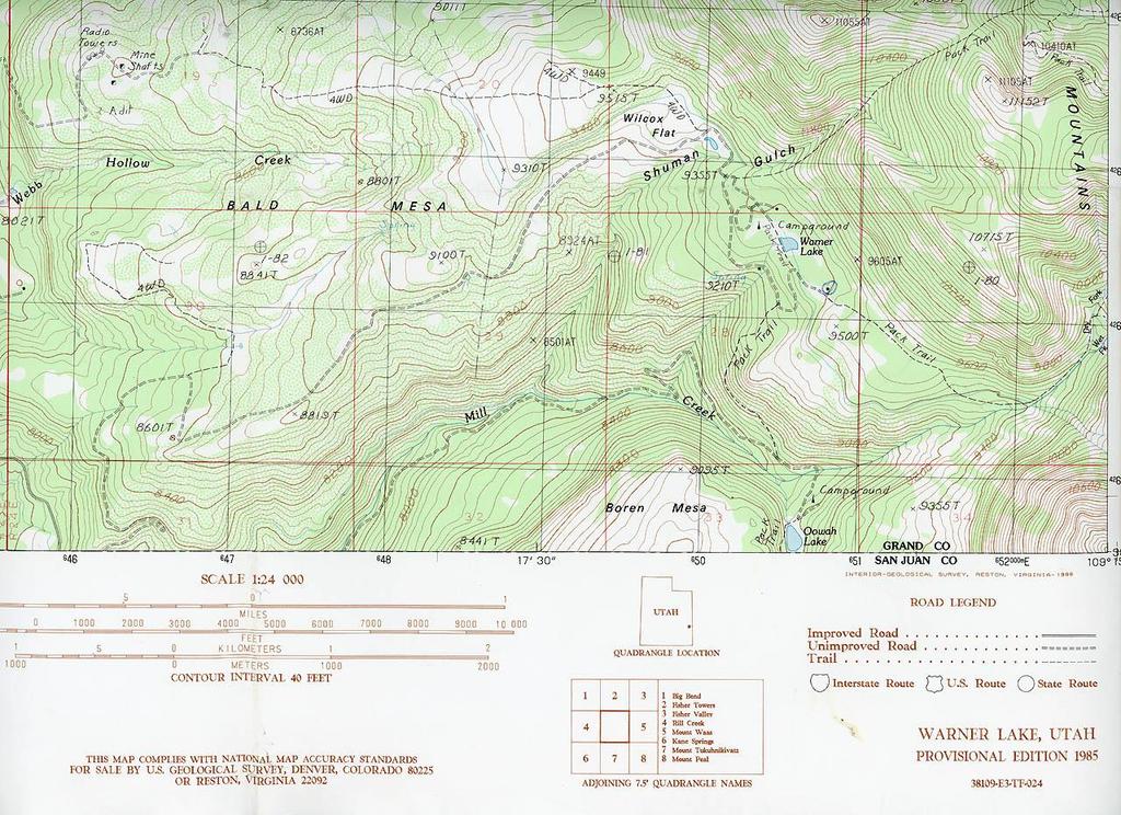
9 Index and Intermediate Contour Lines Contour interval (in this case 40 ft) will be indicated on map
10 New US Topo Maps Just as ICS is now a part of NIMS, US Topo is now a part of The National Map. New US Topo maps are delivered digitally and have several layers, including an Orthoimage layer.
11 New US Topo Maps WGS 84 Stripped down base map (Corrected!! Sorta) Incorporates layers for streets, waterways, satellite image, etc. Updated every 3 years (Utah in 2017) Free Digital PDF files, with paper maps available for $15 ea.


12 2014 US Topo Map Good ol USGS Topo Map

13 2017 US Topo Map Good ol USGS Topo Map


14 2014 US Topo Map Good ol USGS Topo Map

15 2017 US Topo Map Good ol USGS Topo Map What happened to Maloy Park? Upper Porcupine Slickrock?
16 Let s check out a US Topo map.
17 From the GCSAR Certification Standards Explain horizontal datum and how it can affect the transfer of data between a GPS and map.

18 Where is UTM X ? GCSAR Manual error: Page 45, #20
19 From the GCSAR Certification Standards Define and identify the following common grid systems on any map in the GCSAR map packet: Geographic Coordinate System (Lat-Long) Universal Transverse Mercator (UTM) United States Public Land Survey System (Township, Range, Section) When given coordinates in any of the 3 common grid systems, locate that position on a map. Determine coordinates for any point on a map in each of the 3 common grid systems

20 Geographic Coordinate System You are Here
21 Do it in your head or at least on your calculator. Since we get D.d coordinates from dispatch, it would be useful to know how to convert those coordinate to D.M.S. for easier use on a USGS 7.5 Minute topo map. Convert to D.M.S. Multiply X 60 to get Minutes = (for aircraft) Now multiply.03 X 60 to get Seconds = = Since 1 second of latitude equals about 100 feet, we can round off to 2 seconds and only be 20 feet off.


22 Dispatchers sometimes say negative 109. That is not really necessary. But the identical coordinates with a + sign before the 109 will put you in the Ordos Desert 22 miles northwest of Yulin, China. Never vacation there with your dog on the Summer Solstice!
23 From GCSAR s Standards: Explain the difference between the 3 formats within the Geographic Coordinate System and their common uses. Degrees, Minutes, Seconds: This can be the most cumbersome format with which to work. It's a lot like telling time. There are 60 seconds in a minute and 60 minutes in a degree. So one quarter (.25) of a minute is 15 seconds. The only decimal point in this format might appear as a fraction of a second. However, tenths of a second are seldom crucial since a full second is roughly feet. On most GPS units, this will appear as hddd mm'ss.s". Degrees and decimal degrees: This is the standard format for e911 systems, OnStar, SPOT and InReach, and now GCSAR. There are no minutes or seconds in this format, only decimal fractions of a full degree. The number of digits to the right of the decimal point varies. On most GPS units, this will appear as hddd.dddd. Degrees, Minutes and decimal minutes: This is the preferred format for aircraft. There are no seconds in this format, only degrees, minutes, and decimal fractions of a minute. On most GPS units, this will appear as hddd mm.mmm'.


24 UTM Zones NPSAR and SPSAR cannot use UTM because it only extends from 80 degrees South to 84 degrees North

25 11S 13S The Central Meridian in each zone is given a value of 500,000. Easting is in relation to that meridian. Northing refers to meters North of the Equator

26 It s much easier to read accurate UTM coordinates on a topo map than it is to read accurate lat-long coordinates. When might we want to use UTM?

27 Latitude 40º MOAB SINGLETRACK map Features UTM and Dº M.m 38º You should be able to recognize which coordinate systems appear on any map 38º 45
28 Townships are approximately 6 miles square with boundaries conforming to meridians (longitude) and parallels (latitude) as closely as possible. Each Township is typically divided into 36 one-square-mile sections In the above example, the general PLSS description for the La in Lake would be SW ¼, SW ¼, SW ¼, Sec. 14, T2S, R3W. In Utah, this is measured from the SE corner of Temple Square. (SL B&M)

29 Broken Arch NW ¼, NW ¼, Sec. 35, T 23S, R 21E

30
31 U.S. National Grid Reference System Your government at work! A confusing alphanumeric referencing system derived from the Military Grid Reference System where the higher value UTM numbers in the map margin are replaced with letters. You are here: XH The 100,000 meter UTM grid numbers (05, 06, 42, 43 in Grand County) become letters. UTM x (EOC) becomes XH X is the 06, H is the 42, followed by easting of and northing of We won t use NGRS until we are forced to do so, but you need to be able to recognize NGRS coordinates.
32
Chapter 3 Geographic Location Systems
 Chapter 3 Geographic Location Systems In this chapter you will learn about: Latitude and longitude Universal Transverse Mercator (UTM) U.S. Public Land Survey Other geographic location systems Geographic
B. Topographic maps are also called. contour maps
 Topographic Maps Introduction A. Topographic maps are essential tools in geologic and engineering studies because they show the configuration of Earth's surface in remarkable detail and permit one to measure
How does an ellipsoid differ from a sphere in approximating the shape and size of the Earth?
 Chapter 02 Test Bank Worksheet Questions 1. What is a map projection? Topic: Map Projection 2. How does an ellipsoid differ from a sphere in approximating the shape and size of the Earth? Topic: Ellipsoid
Coordinate Systems & Land Division
 Name Physical Geography Lab Activity #06 Due date Coordinate Systems & Land Division COR Objective 1, SLO 1,3 6.1. Introduction Latitude and longitude are great for sailing around the world, but can be
Topographic Maps Self-Instruction Lab (2016 edition) Geology 100 David Harbor s Section. 12 inches x 1 mile
 Geology 100 David Harbor s Section. 12 inches x 1 mile") Topographic Maps Name Self-Instruction Lab (2016 edition) Geology 100 David Harbor s Section Topographic maps are an important aid for a geologist, but maps are also useful for hikers, bicyclists, and
Topographic Maps Name Self-Instruction Lab (2016 edition) Geology 100 David Harbor s Section Topographic maps are an important aid for a geologist, but maps are also useful for hikers, bicyclists, and
Navigating with Map & Compass. Nevada County Sheriff s Search & Rescue
 Navigating with Map & Compass Nevada County Sheriff s Search & Rescue Objectives Very Practical Teach you how to go from point A to point B Go from the wilderness (real world) to a map and visa versa Agenda
Butte County Fire Department
 Butte County Fire Department Basic Land Navigation Verification Sheet I verify that Print Supervisor s name has completed the Print Employee s name Basic Land Navigation self study guide on. Date Attached
UNIT 1C. USING TOPOGRAPHIC MAPS WHERE IN THE WORLD... ARE YOU?
 UNIT 1C. USING TOPOGRAPHIC MAPS WHERE IN THE WORLD... ARE YOU? TIME 60-90 minutes LEVEL All BENCHMARKS Next Generation Science Standards MS-LS1.D Science & Engineering Practices Developing and Using Models
Georeferencing, Map Projections, Cartographic Concepts. -Coordinate Systems -Datum
 Georeferencing, Map Projections, Cartographic Concepts -Map Projections -Coordinate Systems -Datum Map projection is "the process of systematically transforming positions on the Earth's spherical surface
ch02.pdf chap2.pdf chap02.pdf
 Introduction to Geographic Information Systems 8th Edition Karl Solutions Manual Full Download: http://testbanklive.com/download/introduction-to-geographic-information-systems-8th-edition-karl-solutions-manu
Georeferencing. Where on earth are we? Critical for importing and combining layers for mapping
 Georeferencing Where on earth are we? Critical for importing and combining layers for mapping 1. The Geoid Earth is not a perfect sphere, it is ellipsoidal.. earth is the 'Geoid'. The difference between
King County Explorer Search and Rescue. Course B Map & Compass
 King County Explorer Search and Rescue Course B Map & Compass Disclaimer The intent of this presentation is to provide a basic overview of maps, compasses, and location finding. It is not meant to be a
What Do You See? FOR 274: Forest Measurements and Inventory. Area Determination: Frequency and Cover
 What Do You See? Message of the Day: Many options exist to determine the size, area, or extent of a feature on a landscape FOR 274: Forest Measurements and Inventory Lecture 7: Measures of Land Area Frequency
Map Projections & Coordinate Systems
 Map Projections & Coordinate Systems 9/7/2017 1 Why? Laying the Earth Flat Need convenient means of measuring and comparing distances, directions, areas, shapes. Traditional surveying instruments measure
Trail Life USA High Adventure Training Land Navigation Module. Dennis Conte
 Trail Life USA High Adventure Training Land Navigation Module Dennis Conte Navigating With GPS and a MAP Let s Talk about your GPS Hand Held Tool. Is a GPS Hand Held the magic bullet? Can it solve all
Mapping coordinate systems
 Mapping coordinate systems 1. The Earth's Graticule Latitude and Longitude The graticule is the imaginary grid of lines running east-west (lines of latitude = parallels) and north-south lines of longitude
From Science Olympiad Student Center
 1 of 10 3/5/13 8:18 AM Forums Wiki Test Exchange Image Gallery Score Tracker Road Scholar From Science Olympiad Student Center In Road Scholar, Forum Threads Tests There are no images available for this
Butte County Fire Department
 Butte County Fire Department Basic Land Navigation Verification Sheet I verify that Print Supervisor's name Print Employee's name has completed the Basic Land Navigation self study guide on Date Attached
NR402 GIS Applications in Natural Resources Lesson 4 Map Projections
 NR402 GIS Applications in Natural Resources Lesson 4 Map Projections From http://www.or.blm.gov/gis/ 1 Geographic coordinates Coordinates are expressed as Latitude and Longitude in Degrees, Minutes, Seconds
Georeferencing. Place names Postal addresses Postal codes Coordinate systems (lat/long, UTM, etc.)
") Georeferencing Georeferencing Used to describe the act of assigning locations to data or information Certain requirements include that they are: unique, have shared meaning, and are persistent through
Georeferencing Georeferencing Used to describe the act of assigning locations to data or information Certain requirements include that they are: unique, have shared meaning, and are persistent through
Map Projections & Coordinate Systems 1/25/2018
 Map Projections & Coordinate Sstems Laing the Earth Flat How? Projections transformation of curved earth to a flat map; sstematic rendering of the lat. & lon. graticule to rectangular coordinate sstem.
1. Geospatial technology rarely links geospatial data to nonspatial data. a. True *b. False
 Chapter 2 Where in the Geospatial World Are You? 1. Geospatial technology rarely links geospatial data to nonspatial data. 2. For geospatial technology to work, every location on Earth must be: a. inhabited
Basic Map Skills for the Outdoors
 Geography 80-20 80% of what there is to know, for 20% of the sweat Basic Map Skills for the Outdoors Map Scale Map source: US Geological Survey Four ways to indicate map scale: Representative fraction
Analytical and Computer Cartography Lecture 3: Review: Coordinate Systems
 Analytical and Computer Cartography Lecture 3: Review: Coordinate Systems Geographic Coordinates NAD83 NAD27 remained in use until the earthcentered international GRS80 was complete (Geodetic Reference
Intro to GIS Fall 2010 Georeferencing & Map Projections
 Intro to GIS Fall 2010 Georeferencing & Map Projections SHAPE OF THE EARTH Earth's Shape Geoid: shape of earth minus topographic features (irregular due to local variations in gravity) Ellipsoid: elongated
Watershed Sciences 4930 & 6920 GEOGRAPHIC INFORMATION SYSTEMS
 PROJECTS Watershed Sciences 4930 & 6920 GEOGRAPHIC INFORMATION SYSTEMS WEEK THREE Lecture 5 PROJECT DATA/IDEAS, PROJECTIONS (Cont.) & LAB REVIEW Joe Wheaton GUEST LECTURE HOUSEKEEPING: LAB 01 GRADES This
Topographic Maps and Landforms Geology Lab
 Topographic Maps and Landforms Geology Lab Ray Rector: Instructor Today s Lab Activities 1) Discussion of Last Week s Lab 2) Lecture on Topo Maps and Elevation Contours 3) Construct Topographic Maps and
This week s topics. Week 6. FE 257. GIS and Forest Engineering Applications. Week 6
 FE 257. GIS and Forest Engineering Applications Week 6 Week 6 Last week Chapter 8 Combining and splitting landscape features and merging GIS databases Chapter 11 Overlay processes Questions? Next week
Welcome to Lesson 4. It is important for a GIS analyst to have a thorough understanding of map projections and coordinate systems.
 Welcome to Lesson 4. It is important for a GIS analyst to have a thorough understanding of map projections and coordinate systems. A GIS without coordinates would simply be a database like Microsoft Excel
Compass Basics. Quick Map Basics Review For Compass Use
 Compass Basics Quick Map Basics Review For Compass Use A topographic map tells you where things are and how to get to them, whether you're hiking, biking, hunting, fishing, or just interested in the world
Navigation and Communication AS January Sara Mollie Cohen Head Engineer, Department of Arctic Geology
 Navigation and Communication AS101 07-11 January 2019 Sara Mollie Cohen Head Engineer, Department of Arctic Geology Course Objectives Navigation Maps, Coordinate Sysems GPS, TopoSvalbard, Weather Communication
12/26/2012. Geographic Information Systems * * * * GIS (... yrezaei
 ( - Geographic Information Systems ( ( 1 2 3 Information System Data base DB IS IS DB (Knowledge ( ( (System (Information System - (Georefrence Analysis Data + Knowledge ======== Information 4 5 ( < 10%
Basic Land Navigation. Clark County Sheriff Core Comp Rev. # Land Navigation
 Basic Land Navigation Clark County Sheriff Core Comp Rev. # 2018 1 Land Navigation Requirement Through written evaluation the applicant will demonstrate knowledge of land navigation involved in Search
Applied Cartography and Introduction to GIS GEOG 2017 EL. Lecture-1 Chapters 1 and 2
 Applied Cartography and Introduction to GIS GEOG 2017 EL Lecture-1 Chapters 1 and 2 What is GIS? A Geographic Information System (GIS) is a computer system for capturing, storing, querying, analyzing and
Lecture 9: Reference Maps & Aerial Photography
 Lecture 9: Reference Maps & Aerial Photography I. Overview of Reference and Topographic Maps There are two basic types of maps? Reference Maps - General purpose maps & Thematic Maps - maps made for a specific
What is a map? A Map is a two or three-dimensional model or representation of the Earth s surface. 2-Dimensional map
 What is a map? A Map is a two or three-dimensional model or representation of the Earth s surface. 2-Dimensional map What is a Map Projection? Planar Projection Projection A Projection is a mathematical
Latitude and Longitude, Plus Map Scale
 Name Lab 4 More Date: Latitude and Longitude, Plus Map Scale In the first few labs of the semester, you found that you needed to look at a variety of maps to answer all the questions. One reason you needed
Notes on Projections Part II - Common Projections James R. Clynch February 2006
 Notes on Projections Part II - Common Projections James R. Clynch February 2006 I. Common Projections There are several areas where maps are commonly used and a few projections dominate these fields. An
Fri. Jan. 26, Demonstration of QGIS with GPS tracks. Types of data, simple vector (shapefile) formats
 formats") Fri. Jan. 26, 2018 Demonstration of QGIS with GPS tracks Types of data, simple vector (shapefile) formats Map projections, Coordinate Reference Systems Demonstration of QGIS with geologic map 1 Raster
Fri. Jan. 26, 2018 Demonstration of QGIS with GPS tracks Types of data, simple vector (shapefile) formats Map projections, Coordinate Reference Systems Demonstration of QGIS with geologic map 1 Raster
Navigation. Longitude and Latitude Foundations of Navigation. MTPs:
 Navigation 3.01 Foundations of Navigation References: FTGU pages 177-178, 184-190 Transport Canada Study and Reference Guide Glider Pilot Canada Flight Training Manual Pilot Navigation http://en.wikipedia.org/wiki/transverse_mercator_projection#spherical_transverse_mercator
WHERE ARE YOU? Maps & Geospatial Concepts Fall 2012
 WHERE ARE YOU? Maps & Geospatial Concepts Fall 2012 Where are you? Relative location I m at school Absolute Location 45 26 18.07 122 43 50.78 Datums Datums A reference surface of the Earth Used as the
Topographic Map Series:
 DEFINITION OF A MAP A MAP IS A GEOGRAPHIC PREPRESENTATION OF A PORTION OF THE EARTH S SURFACE DRAWN TO SCALE, AS SEEN FROM ABOVE. IT S USES COLORS, SYMBOLS AND LABELS TO REPRESENT FEATURES FOUND ON THE
Map Projections & Coordinate Systems 9/10/2013. Why? M. Helper GEO327G/386G, UT Austin 2. M. Helper GEO327G/386G, UT Austin 4
 Map Projections & Coordinates Laing the earth flat Wh? Need convenient means of measuring and comparing distances, directions, areas, shapes. Traditional surveing instruments measure in meters or feet,
Shape e o f f the e Earth
 1 Coordinate Systems & Projections Coordinate Systems Two map layers are not going to register spatially unless they are based on the same coordinate system. 2 Contents Shape of the earth Datum Projections
1. Label a few examples of lines of latitude and lines of longitude on the globe above left.
 Oceanography 2 Location, Direction, and Distance on Nautical Charts Please read Appendix III in the textbook for reference. Learning Objectives for the first nautical chart Lab 1. Use the latitude-longitude
BUILDING AN ACCURATE GIS
 BUILDING AN ACCURATE GIS 2006 GIS in the Rockies Denver, Colorado September 13, 2006 William E. Linzey United States Department of Commerce National Oceanic and Atmospheric Administration National Geodetic
Map Projections & Coordinate Systems 9/7/2017
 Map Projections & Coordinate Sstems Laing the Earth Flat Wh? Need convenient means of measuring and comparing distances, directions, areas, shapes. Traditional surveing instruments measure in meters or
SECTION 4 PARCEL IDENTIFIERS 4.1 LONGITUDE AND LATITUDE
 SECTION 4 PARCEL IDENTIFIERS 4.1 LONGITUDE AND LATITUDE Most maps must be drawn in such a way that points and areas can be located accurately on the earth's surface and described objectively. A uniform
Coach Answers Part 2 Zombie 17 COACH ANSWERS (Questions and answers with explanations) Part 2
 Part 2") Zombie 17 COACH ANSWERS (Questions and answers with explanations) Part 2 44. The Brain Building looks fairly new. Based on the map, what is the most recent year in which it could have been constructed?
Zombie 17 COACH ANSWERS (Questions and answers with explanations) Part 2 44. The Brain Building looks fairly new. Based on the map, what is the most recent year in which it could have been constructed?
Lecture 4. Coordinate Systems & Projections
 Lecture 4 Coordinate Systems & Projections Outline Geodesy Geoids Ellipsoids Geographic Coordinate Systems Magnetic North vs. True North Datums Projections Applying Coordinate Systems and Projections Why
GIST 3300 / Geographic Information Systems. Last Time. Today
 GIST 3300 / 5300 Last Time Ellipsoids and Datums Today Map Projections Map Projections Today we will build on the concepts of Geographic Coordinate Systems, Ellipsoids and Datums and add the concepts of
Public Land Survey System Knowledge Remains an Important Skill
 By Douglas S. Helmke, P.G., Water Rights / Source Water Specialist Public Land Survey System Knowledge Remains an Important Skill In our new world of global positioning system (GPS) navigation, with digital
Introduction to Geographic Information Science. Updates/News. Last Lecture. Geography 4103 / Map Projections and Coordinate Systems
 Geography 4103 / 5103 Introduction to Geographic Information Science Map Projections and Coordinate Systems Updates/News Thursday s lecture Reading discussion 1 find the readings online open questions,
What is a Map Projection?
 What is a Map Projection? It is how we represent a three dimensional Earth on a flat piece of paper However The process of transferring information from the Earth to a map causes every projection to distort
Lecture Outline. Geography 12: Maps and Mapping. Review questions. Review questions. Large and Small Scale Maps. Large and Small Scale Maps
 Lecture Outline Geography 12: Maps and Mapping Lecture 3: Scale and Cognitive Maps Today s fun map: http://symptoms.webmd.com/map/ Review of Geodesy, Latitude & Longitude, Datums, and Reference Grids Scale
Importance of Understanding Coordinate Systems and Map Projections.
 Importance of Understanding Coordinate Systems and Map Projections. 1 It is extremely important that you gain an understanding of coordinate systems and map projections. GIS works with spatial data, and,
Wed. Apr. 25, 2018 GIS DEMO. Reading: Ch Comparing Image Types (Death Valley) Treat as review of techniques already studied
 Treat as review of techniques already studied") Wed. Apr. 25, 2018 GIS DEMO Reading: Ch. 14 -- Comparing Image Types (Death Valley) Treat as review of techniques already studied 1 GIS: Geographic Information Systems Way to organize data obtained by
Wed. Apr. 25, 2018 GIS DEMO Reading: Ch. 14 -- Comparing Image Types (Death Valley) Treat as review of techniques already studied 1 GIS: Geographic Information Systems Way to organize data obtained by
SPCS2022 in North Carolina
 SPCS2022 in North Carolina New State Plane Coordinate System in 2022 Will replace SPCS 83 Referenced to new terrestrial reference frames Two conflicting desires for SPCS2022 coordinates: Change coordinates
Control Surveys and Coordinate Systems
 Control Surveys and Coordinate Systems The Earth is Round Basic Shape of the Earth: Oblate Spheroid of Revolution The length of the equatorial axis is approximately 27 miles greater than the polar axis.
GPS Mapping. Teacher Instructions. Overview: Objectives: Materials: Answers to Student Worksheets:
 Overview: Scientists use Global Positioning System (GPS) receivers to map lava flows. GPS data are compiled by computer Geographic Information System (GIS) software into a digital map. Digital maps can
GIS in Water Resources Fall 2018 Homework #1
 GIS in Water Resources Fall 2018 Homework #1 Goal The goal of this homework is to reinforce the lecture material on Geodesy, Map Projections and Coordinate Systems by having you identify attributes and
Geo Referencing & Map projections CGI-GIRS 0910
 Geo Referencing & Map projections CGI-GIRS 0910 Where are you? 31UFT8361 174,7 441,2 51 58' NB 5 40' OL 2/60 Who are they? 3/60 Do geo data describe Earth s phenomena perfectly? Georeference systems ellipsoid
Referencing map features: Coordinate systems and map projections
 Referencing map features: Coordinate systems and map projections Coordinate systems and map projections if we want to integrate geographic data from many different sources, we need to use a consistent
GIS in Water Resources. Fall Homework #1
 GIS in Water Resources Fall 2015 Homework #1 Goal The goal of this homework is to reinforce the lecture material on Geodesy, Map Projections and Coordinate Systems by having you identify attributes and
Geo Referencing & Map projections CGI-GIRS 0910
 Geo Referencing & Map projections CGI-GIRS 0910 Where are you? 31UFT8361 174,7 441,2 51 58' NB 5 40' OL 2/60 Who are they? 3/60 Do geo data describe Earth s phenomena perfectly? Georeference systems ellipsoid
Lecture 10-14: Map Projections and Coordinate System
 URP 1281 Surveying and Cartography Lecture 10-14: Map Projections and Coordinate System December 27, 2015 Course Teacher: Md. Esraz-Ul-Zannat Assistant Professor Department of Urban and Regional Planning
Solving the "Grid to Ground Problem" with Custom Coordinate Systems CV327-6 About the Speaker:
 Solving the "Grid to Ground Problem" with Custom Coordinate Systems Richard Sincovec, LSI Director of Technology, Edward James Surveying President, Quux Software CV327-6 Grid projections such as the State
Lab Topographic Maps. Name: Partner: Purpose. Background Information
 Lab Topographic Maps Name: Partner: Purpose The purpose of this lab is to familiarize you with graphic representations of the Earth s surface primarily maps. Simple line maps show the spatial relationship
Coordinate Systems and Map James Frew ESM 263 Winter
 Coordinate Systems and Map Projec@ons 1 Outline Introduc@on La@tude and longitude Projec@ons and coordinate systems Placenames Postal addresses and postal codes Linear referencing systems Cadasters Conver@ng
Lesson 5: Map Scale and Projections
 Organizing Data and Information Lesson 5: Map Scale and Projections Map Scales Projections Information can be organized as lists, numbers, tables, text, pictures, maps, or indexes. Clusters of information
Sites Field Descriptions
 Accession# Additional Location Details This is the controlling number of the collections. It relates a site to an Accession. [ACCESSNO : Character (15)] Use this unlimited notes field to enter any addition
Earth Science Regents Reading Topographic Maps
 Earth Science Regents Reading Topographic Maps Name Period Quick Tutorial on Degrees, Minutes, and Seconds of Latitude and Longitude A degree of latitude on the surface of the earth is about 70 miles long.
USING THE MILITARY LENSATIC COMPASS
 USING THE MILITARY LENSATIC COMPASS WARNING This presentation is intended as a quick summary, and not a comprehensive resource. If you want to learn Land Navigation in detail, either buy a book; or get
Coordinate Systems. Location on earth is defined by coordinates
 Coordinate Systems We think of the earth as a sphere It is actually a spheroid (ellipsoid), slightly larger in radius at the equator than at the poles Shape of the Earth Location on earth is defined by
When the Earth Was Flat. Measurements were made using a plumb bob, a spirit level, and a stick. Also, the Stars.
 ABSTRACT Defining the shape of the Earth geoid. Mathematical models spheroid or ellipsoid Mathematical projection of geodetic systems GIS/GPS technology The need for a unified projection systems World
Chapter 1 Homework - Elements of Real Estate Law
 Chapter 1 Homework - Elements of Real Estate Law The following questions are a small example of what you might expect to see on the Real Estate Law portion of the Cadastral Mapping exam. First try answering
GEOGRAPHIC COORDINATE SYSTEMS
 GEOGRAPHIC COORDINATE SYSTEMS Introduction to GIS Winter 2015 What is Georeferencing? Used to establish a location on the Earth s surface 1 st order polynomial transformation Georeferencing toolbar What
Preventing Coordinate- System Confusion (maybe?)
") Preventing Coordinate- System Confusion (maybe?) Montana Association of Registered Land Surveyors 2008 Convention Bozeman, Montana 07 & 08 February 2008 Glenn Borkenhagen Inland GPS Inc. - Cody, Wyoming
Preventing Coordinate- System Confusion (maybe?) Montana Association of Registered Land Surveyors 2008 Convention Bozeman, Montana 07 & 08 February 2008 Glenn Borkenhagen Inland GPS Inc. - Cody, Wyoming
FM Map Reading and Land Navigation
 FM 3-25.26 Map Reading and Land Navigation CHAPTER 4 GRIDS This chapter covers how to determine and report positions on the ground in terms of their locations on a map. Knowing where you are (position
Map Projections. Displaying the earth on 2 dimensional maps
 Map Projections Displaying the earth on 2 dimensional maps Map projections Define the spatial relationship between locations on earth and their relative locations on a flat map Are mathematical expressions
Spatial locations. Spatial locations. Spatial locations. Spatial locations
 Where am I? sounds simple, but definitely not huge amount of picky detail Cartographers make a career from the details focus on the minimum you need to know c Philip M. Dixon (Iowa State Univ.) Spatial
Laboratory Exercise #2 Introduction to Quadrangle Maps
 page - 1 Laboratory Exercise #2 Introduction to Quadrangle Maps A. Introduction to Quadrangle Maps The United States Geological Survey has developed a nationwide series of quadrangle maps that cover small
APPLICATION FOR CHANGE OF WATER RIGHT
 District Court, Water Division, Colorado Court Address: CONCERNING THE APPLICATION FOR WATER RIGHTS OF Applicant: In the River or its Tributaries In COUNTY COURT USE ONLY Attorney or Party Without Attorney
Laboratory Exercise #2 Introduction to Quadrangle Maps
 page - Laboratory Exercise #2 Introduction to Quadrangle Maps A. Introduction to Quadrangle Maps The United States Geological Survey has developed a nationwide series of quadrangle maps that cover small
LESSON 2: INTRODUCTION TO TOPOGRAPHICAL MAPS
 LESSON 2: INTRODUCTION TO TOPOGRAPHICAL MAPS Finding your way if you become separated from a group. PURPOSE This lesson presents an overview of topographic maps. It describes their characteristics and
Cartography the art of making maps
 Cartography the art of making maps A map is a drawing or a picture of the earths surface, showing how things are related to each other by distance, direction and size. Maps are used for: Navigation Distance
Charts and Chart Work with Poole Sailing
 with Poole Sailing Nautical charts are a mine of information but they need to be up to date. Corrections to charts are published by the Hydrographic Office monthly as Notices to Mariners both in print
Name of Applicant Mailing Address address Telephone Number
 District Court, Water Division, Colorado Court Address: CONCERNING THE APPLICATION FOR WATER RIGHTS OF Applicant: In the River or its Tributaries In COUNTY Attorney or Party Without Attorney (Name and
AS 410 Land Navigation. Chpt 4-1
 AS 410 Land Navigation Chpt 4-1 Overview Types of Maps Map Legends / Scales Latitude and Longitude Orienteering Why? Why important to learn how to read a compass and map? No cell phone coverage Mountain
WHERE ARE YOU? Maps & Geospatial Concepts Fall 2015
 WHERE ARE YOU? Maps & Geospatial Concepts Fall 2015 Where are you? Relative location I m at school Absolute Location 45 26 18.07 122 43 50.78 Where is Boston? Introducing Geodesy, Ellipsoids & Geoids Geodesy
Georeferencing. Geography is the key to linking attributes. Georeferencing is the key to geography.
 Georeferencing Geography is the key to linking attributes. Georeferencing is the key to geography. Why georeferencing? Many reasons for having georeferences Many different approaches to georeferencing
APPLICATION FOR SIMPLE CHANGE IN SURFACE POINT OF DIVERSION PURSUANT TO (3.5), C.R.S.
, C.R.S.") District Court, Water Division, Colorado Court Address: CONCERNING THE APPLICATION FOR WATER RIGHTS OF Applicant: In the River or its Tributaries In COUNTY COURT USE ONLY Attorney or Party Without Attorney
District Court, Water Division, Colorado Court Address: CONCERNING THE APPLICATION FOR WATER RIGHTS OF Applicant: In the River or its Tributaries In COUNTY COURT USE ONLY Attorney or Party Without Attorney
Military Map Reading 201
 Military Map Reading 201 This information paper is designed to resolve the confusion between the Universal Transverse Mercator (UTM) and the Military Grid Reference System (MGRS) coordinates. The two systems
EnvSci360 Computer and Analytical Cartography
 EnvSci360 Computer and Analytical Cartography Lecture 3 Geodesy Map Projections, Datums, and Coordinate Systems 1 Geodesy The science of measuring and representing the shape and size of the earth, and
Lecture Plan. GEOL 452/552 - GIS for Geoscientists I. Why use Projections? Lecture 15 - chapter 11. Different types of Projections
 GEOL 452/552 - GIS for Geoscientists I Lecture 15 - chapter 11 Lecture Plan Ch. 11, one lecture Coordinate systems Projection, Datums, Dpheroid Unprojected (geographic) coord. syst., UTM On the fly projection
Geology 101 Lab Worksheet: Topographic Maps
 Geology 101 Lab Worksheet: Topographic Maps Name: Refer to the Topographic Maps Lab for the information you need to complete this worksheet (http://commons.wvc.edu/rdawes/g101ocl/labs/topomapslab.html).
Maps and Globes. By Kennedy s Korner
 Maps and Globes By Kennedy s Korner Map Key or Symbols Maps use symbols to show places and things on Earth. Symbols are drawings that stand for something real. A map key tells you what each symbol stands
Projections & GIS Data Collection: An Overview
 Projections & GIS Data Collection: An Overview Projections Primary data capture Secondary data capture Data transfer Capturing attribute data Managing a data capture project Geodesy Basics for Geospatial
Background Information
 Oceanography LAB #1: Marine Charts and Navigation Background Information Latitude and Longitude A coordinate is an address a means of designating location. Most coordinate systems involve a network of
CHAIRMAN OF THE JOINT CHIEFS OF STAFF INSTRUCTION
 CHAIRMAN OF THE JOINT CHIEFS OF STAFF INSTRUCTION J-3 CJCSI 3900.01C DISTRIBUTION: A, B, C, J POSITION (POINT AND AREA) REFERENCE PROCEDURES Reference: DODD 5105.60, 11 October 1996, National Imagery and