Georeferencing, Map Projections, Cartographic Concepts. -Coordinate Systems -Datum
|
|
|
- Marshall Nicholson
- 5 years ago
- Views:
Transcription
1 Georeferencing, Map Projections, Cartographic Concepts -Map Projections -Coordinate Systems -Datum
2 Map projection is "the process of systematically transforming positions on the Earth's spherical surface to a flat map while maintaining spatial relationships. This process is accomplished by the use of geometry or, more commonly, by mathematical formulas. Map projection can be best visualized by imagining a light bulb placed at the center of a transparent globe and having its lines of longitude and latitude cast upon either a flat sheet of paper or a sheet of paper rolled into a cylinder or cone placed over the globe." (from Glossary of cartographic terms: map projection).
3 Map projections fall into four general classes. Cylindrical projections result from projecting a spherical surface onto a cylinder. Conic projections result from projecting a spherical surface onto a cone. Azimuthal projections result from projecting a spherical surface onto a plane. Miscellaneous projections include unprojected ones such as rectangular latitude and longitude grids and other examples of that do not fall into the cylindrical, conic, or azimuthal categories
.")
4 Cylindrical projections When the cylinder is tangent to the sphere contact is along a great circle (the circle formed on the surface of the Earth by a plane passing through the center of the Earth).

5 Cylindrical projections In the secant case, the cylinder touches the sphere along two lines, both small circles (a circle formed on the surface of the Earth by a plane not passing through the center of the Earth).

6 Cylindrical projections When the cylinder upon which the sphere is projected is at right angles to the poles, the cylinder and resulting projection are transverse.


7 Cylindrical projections When the cylinder is at some other, non-orthogonal, angle with respect to the poles, the cylinder and resulting projection is oblique.


8 Conic projections When the cone is tangent to the sphere contact is along a small circle.


9 Conic projections In the secant case, the cone touches the sphere along two lines, one a great circle, the other a small circle.


10 Azimuthal projections When the plane is tangent to the sphere contact is at a single point on the surface of the Earth.

11 Azimuthal projections In the secant case, the plane touches the sphere along a small circle if the plane does not pass through the center of the earth, when it will touch along a great circle.
12 Map projections are attempts to portray the surface of the earth or a portion of the earth on a flat surface. Some distortions of conformality, distance, direction, and area always result from this process. Some projections minimize distortions in some of these properties at the expense of maximizing errors in others. Some projection are attempts to only moderately distort all of these properties.
13 Conformality-When the scale of a map at any point on the map is the same in any direction, the projection is conformal. Meridians (lines of longitude) and parallels (lines of latitude) intersect at right angles. Shape is preserved locally on conformal maps. Distance-A map is equidistant when it portrays distances from the center of the projection to any other place on the map. Direction-A map preserves direction when azimuths (angles from a point on a line to another point) are portrayed correctly in all directions. Area-When a map portrays areas over the entire map so that all mapped areas have the same proportional relationship to the areas on the Earth that they represent, the map is an equalarea map.

14 Different map projections result in different spatial relationships between regions.

15 Mercator-The Mercator projection has straight meridians and parallels that intersect at right angles. Scale is true at the equator or at two standard parallels equidistant from the equator. The projection is often used for marine navigation because all straight lines on the map are lines of constant azimuth.

16 Unprojected Maps Unprojected maps include those that are formed by considering longitude and latitude as a simple rectangular coordinate system. Scale, distance, area, and shape are all distorted with the distortion increasing toward the poles.
17 Lambert Conformal Conic Area, and shape are distorted away from standard parallels. Directions are true in limited areas. Used for maps of North America.

18 Different map projections result in different spatial relationships between regions.
19 Albers Equal Area Conic A conic projection that distorts scale and distance except along standard parallels. Areas are proportional and directions are true in limited areas. Used in the United States and other large countries with a larger east-west than north-south extent.
20 Transverse Mercator Transverse Mercator projections result from projecting the sphere onto a cylinder tangent to a central meridian. Transverse Mercator maps are often used to portray areas with larger northsouth than east-west extent. Distortion of scale, distance, direction and area increase away from the central meridian. Many national grid systems are based on the Transverse Mercator projection The British National Grid (BNG) is based on the National Grid System of England, administered by the British Ordnance Survey.


21 The British National Grid (BNG) is based on the National Grid System of England, administered by the British Ordnance Survey. The true origin of the system is at 49 degrees north latitude and 2 degrees west longitude. The false origin is 400 km west and 100 km north. Scale at the central meridian is The first BNG designator defines a 500 km square. The second designator defines a 100 km square. The remaining numeric characters define 10 km, 1 km, 100 m, 10 m, or 1 m eastings and northings.
22 Texas State-Wide Projection In 1992, the Cartographic Standards Working Group proposed a Texas State-Wide Map Projection Standard for the GIS Standards Committee of the GIS Planning Council for the Department of Information Sciences. Earlier maps had often used projections designed for the continental United States
23 COORDINATE SYSTEMS An overview of coordinate systems for georeferencing provides a brief description of local and global systems for use in precise positioning, navigation, and geographic information systems for the location of points in space. There are many different coordinate systems, based on a variety of geodetic datums, units, projections, and reference systems in use today.
24 Basic Coordinate Systems There are many basic coordinate systems familiar to students of geometry and trigonometry. These systems can represent points in two-dimensional or threedimensional space. René Descartes ( ) introduced systems of coordinates based on orthogonal (right angle) coordinates. These two and three-dimensional systems used in analytic geometry are often referred to as Cartesian systems. Similar systems based on angles from baselines are often referred to as polar systems.


25 Plane Coordinate Systems Two-dimensional coordinate systems are defined with respect to a single plane.
26
27 Three-Dimensional Systems Three-dimensional coordinate systems can be defined with respect to two orthogonal planes.

28 Coordinate Systems Global Systems Latitude, Longitude, Height The most commonly used coordinate system today is the latitude, longitude, and height system. The Prime Meridian and the Equator are the reference planes used to define latitude and longitude. Equator and Prime Meridian


29 Geodetic Latitude, Longitude, and Height The geodetic latitude (there are many other defined latitudes) of a point is the angle from the equatorial plane to the vertical direction of a line normal to the reference ellipsoid. The geodetic longitude of a point is the angle between a reference plane and a plane passing through the point, both planes being perpendicular to the equatorial plane. The geodetic height at a point is the distance from the reference ellipsoid to the point in a direction normal to the ellipsoid.
 define three dimensional positions with respect to the center of mass")
30 ECEF X, Y, Z Earth Centered, Earth Fixed Cartesian coordinates are also used to define three dimensional positions. Earth centered, earth-fixed, X, Y, and Z, Cartesian coordinates (XYZ) define three dimensional positions with respect to the center of mass of the reference ellipsoid.
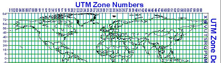
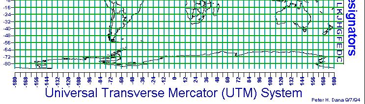
31 Universal Transverse Mercator (UTM) Universal Transverse Mercator (UTM) coordinates define two dimensional, horizontal, positions. UTM zone numbers designate 6 degree longitudinal strips extending from 80 degrees South latitude to 84 degrees North latitude. UTM zone characters designate 8 degree zones extending north and south from the equator.
32

33 World Geographic Reference System Index (GEOREF) The World Geographic Reference System is used for aircraft navigation. GEOREF is based on latitude and longitude. The globe is divided into twelve bands of latitude and twenty-four zones of longitude, each 15 degrees in extent.
34 State Plane Coordinates In the United States, the State Plane System was developed in the 1930s and was based on the North American Datum 1927 (NAD27). NAD 27 coordinates are based on the foot. While the NAD-27 State Plane System has been superseded by the NAD-83 System, maps in NAD-27 coordinates (in feet) are still in use.


35 State Plane Zone Example
36 Most USGS 7.5 Minute Quadrangles use several coordinate system grids including latitude and longitude, UTM kilometer tic marks, and applicable State Plane coordinates. The State Plane System 1983 is based on the North American Datum 1983 (NAD83). NAD 83 coordinates are based on the meter. State plane systems were developed in order to provide local reference systems that were tied to a national datum. Some smaller states use a single state plane zone. Larger states are divided into several zones. State plane zone boundaries often follow county boundaries.
37 Three Coordinate Systems on the Austin, East USGS 7.5' Quadrangle
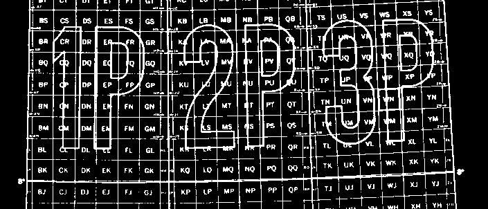
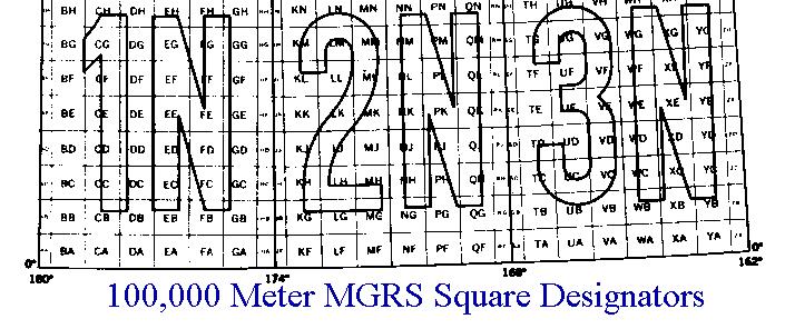
38 Military Grid Reference System (MGRS) The Military Grid Reference System (MGRS) is an extension of the UTM system. UTM zone number and zone character are used to identify an area 6 degrees in east-west extent and 8 degrees in north-south extent. UTM zone number and designator are followed by 100 km square easting and northing identifiers. The system uses a set of alphabetic characters for the 100 km grid squares. Starting at the 180 degree meridian the characters A to Z (omitting I and O) are used for 18 degrees before starting over. From the equator north the characters A to V (omitting I and O) are used for 100 km squares, repeating every 2,000 km.
39
40 AT&T V and H Coordinate System The AT&T V and H (Vertical and Horizontal) coordinate system was devised in 1957 by Jay K. Donald for the easy computation of distances between telephone switching centers. The system is based on the Donald Elliptic Projection, a two-point equidistant projection covering the land masses of the continental United States and Canada. The system is based on units of the square-root of one-tenth of a mile.


41 AT&T V and H Coordinates - Donald Elliptic Projection
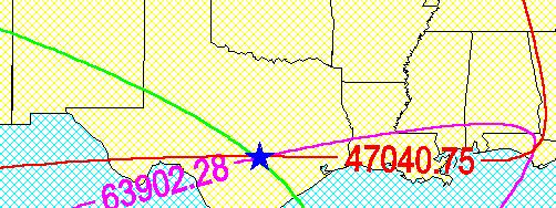
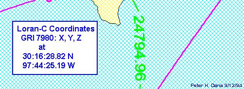
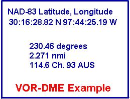
42 Navigation systems can define locations by referencing measurements of electronic signals. Loran-C time-differences can identify positions with an accuracy of one-quarter of a mile. Loran-C Time Differences Omega phase-differences can identify positions with an accuracy of 1-5 kms. VOR-DME (Very high frequency Omni Range - Distance Measuring) measurements from an aircraft can identify locations with an accuracy of kms. VOR-DME Chart Detail VOR - DME Coordinates
43
44 Postal Codes Postal codes such as the United States ZIP code can be used to identify areas. Three digit codes identify large areas. Public Land Rectangular Surveys Public Land Rectangular Surveys have been used since the 1790s to identify public lands in the United States. The system is based on principal meridians and baselines. Townships, approximately six miles square, are numbered with reference to baseline and principal meridian. Ranges are the distances and directions from baseline and meridian expressed in numbers of townships. Every four townships a new baseline is established so that orthogonal meridians can remain north oriented.
45 Public Land Rectangular Surveys

46
47 What are NAD 27 and NAD 83? The North American Datum of 1927 (NAD 27) is "The horizontal control datum for the United States that (was) defined by (a) location and azimuth on the Clarke spheroid of 1866, with origin at (the survey station) Meades Ranch."... The geoidal height at Meades Ranch (was) assumed to be zero.
48 "This datum, designated as NAD 83, is the new geodetic reference system.... NAD 83 is based on the adjustment of 250,000 points including 600 satellite Doppler stations which constrain the system to a geocentric origin." (Geodetic Glossary, pp 57) The North American Datum of 1983 (NAD 83) is "The horizontal control datum for the United States, Canada, Mexico, and Central America, based on a geocentric origin and the Geodetic Reference System 1980.
49 The NAD 27 was based on the Clarke Ellipsoid of 1866 and the NAD 83 is based on the Geodetic Reference System of The NAD 27 was computed with a single survey point, MEADES RANCH in Kansas, as the datum point, while the NAD 83 was computed as a geocentric reference system with no datum point. NAD 83 has been officially adopted as the legal horizontal datum for the United States by the Federal government, and has been recognized as such in legislation in 44 of the 50 states. The computation of the NAD 83 removed significant local distortions from the network which had accumulated over the years, using the original observations, and made the NAD 83 much more compatible with modern survey techniques
50 Geodetic Datums Datum Types Datum types include horizontal, vertical and complete datums. Datums in Use Hundreds of geodetic datums are in use around the world. The Global Positioning system is based on the World Geodetic System 1984 (WGS-84). Parameters for simple XYZ conversion between many datums and WGS-84 are published by the Defense mapping Agency.
51 Geodetic datums define size and shape of the earth the origin and orientation of the coordinate systems used to map the earth Hundreds of different datums have been used to frame position descriptions since the first estimates of the earth's size were made by Aristotle. Datums have evolved from those describing a spherical earth to ellipsoidal models derived from years of satellite measurements.

52 The earth has a highly irregular and constantly changing surface. Models of the surface of the earth are used in navigation, surveying, and mapping. Topographic and sea-level models attempt to model the physical variations of the surface, while gravity models and geoids are used to represent local variations in gravity that change the local definition of a level surface
53 Referencing geodetic coordinates to the wrong datum can result in position errors of hundreds of meters. Different nations and agencies use different datums as the basis for coordinate systems used to identify positions in geographic information systems, precise positioning systems, and navigation systems. The diversity of datums in use today and the technological advancements that have made possible global positioning measurements with sub-meter accuracies requires careful datum selection and careful conversion between coordinates in different datums.
54 I hope you enjoyed the lecture today!
Georeferencing. Place names Postal addresses Postal codes Coordinate systems (lat/long, UTM, etc.)
") Georeferencing Georeferencing Used to describe the act of assigning locations to data or information Certain requirements include that they are: unique, have shared meaning, and are persistent through
Georeferencing Georeferencing Used to describe the act of assigning locations to data or information Certain requirements include that they are: unique, have shared meaning, and are persistent through
What is a Map Projection?
 What is a Map Projection? It is how we represent a three dimensional Earth on a flat piece of paper However The process of transferring information from the Earth to a map causes every projection to distort
Map Projections & Coordinate Systems
 Map Projections & Coordinate Systems 9/7/2017 1 Why? Laying the Earth Flat Need convenient means of measuring and comparing distances, directions, areas, shapes. Traditional surveying instruments measure
WHERE ARE YOU? Maps & Geospatial Concepts Fall 2012
 WHERE ARE YOU? Maps & Geospatial Concepts Fall 2012 Where are you? Relative location I m at school Absolute Location 45 26 18.07 122 43 50.78 Datums Datums A reference surface of the Earth Used as the
Intro to GIS Fall 2010 Georeferencing & Map Projections
 Intro to GIS Fall 2010 Georeferencing & Map Projections SHAPE OF THE EARTH Earth's Shape Geoid: shape of earth minus topographic features (irregular due to local variations in gravity) Ellipsoid: elongated
WHERE ARE YOU? Maps & Geospatial Concepts Fall 2015
 WHERE ARE YOU? Maps & Geospatial Concepts Fall 2015 Where are you? Relative location I m at school Absolute Location 45 26 18.07 122 43 50.78 Where is Boston? Introducing Geodesy, Ellipsoids & Geoids Geodesy
Map projections. Rüdiger Gens
 Rüdiger Gens Coordinate systems Geographic coordinates f a: semi-major axis b: semi-minor axis Geographic latitude b Geodetic latitude a f: flattening = (a-b)/a Expresses as a fraction 1/f = about 300
This week s topics. Week 6. FE 257. GIS and Forest Engineering Applications. Week 6
 FE 257. GIS and Forest Engineering Applications Week 6 Week 6 Last week Chapter 8 Combining and splitting landscape features and merging GIS databases Chapter 11 Overlay processes Questions? Next week
Map Projections. What does the world look like? AITOFF AZIMUTHAL EQUIDISTANT BEHRMANN EQUAL AREA CYLINDRICAL
 Map Projections What does the world look like? AITOFF AZIMUTHAL EQUIDISTANT BEHRMANN EQUAL AREA CYLINDRICAL 1 CYLINDRICAL EQUAL AREA BONNE CRASTER PARABOLIC 2 ECKERT I ECKERT III ECKERT V There are many
Working with georeferenced data. What is georeferencing? Coordinate Systems. Geographic and Projected Coordinate System
 GIS501 Fundamentals of Geographical Information Systems (GIS) Coordinate Systems Working with georeferenced data What is georeferencing? Geographically referenced data which is, in some way, referenced
Shape e o f f the e Earth
 1 Coordinate Systems & Projections Coordinate Systems Two map layers are not going to register spatially unless they are based on the same coordinate system. 2 Contents Shape of the earth Datum Projections
Geographic coordinate systems
 1 Geographic coordinate systems In this chapter you ll learn about longitude and latitude. You ll also learn about the parts that comprise a geographic coordinate system including Spheres and spheroids
NR402 GIS Applications in Natural Resources Lesson 4 Map Projections
 NR402 GIS Applications in Natural Resources Lesson 4 Map Projections From http://www.or.blm.gov/gis/ 1 Geographic coordinates Coordinates are expressed as Latitude and Longitude in Degrees, Minutes, Seconds
Outline. Shape of the Earth. Geographic Coordinates (φ, λ, z) Ellipsoid or Spheroid Rotate an ellipse around an axis. Ellipse.
 Ellipsoid or Spheroid Rotate an ellipse around an axis. Ellipse.") Map Projections Outline Geodesy and map projections Prof. D. Nagesh Kumar Department of Civil Engineering Indian Institute of Science Bangalore 560 012, India http://www.civil.iisc.ernet.in/~nagesh Shape
Map Projections Outline Geodesy and map projections Prof. D. Nagesh Kumar Department of Civil Engineering Indian Institute of Science Bangalore 560 012, India http://www.civil.iisc.ernet.in/~nagesh Shape
Map projections. Rüdiger Gens
 Rüdiger Gens 2 Outline! Relevant terms! Why map projections?! Map projection categories " Projection surfaces " Features preserved from distortions! Map projection examples! Right choice Relevant terms!
GIST 3300 / Geographic Information Systems. Last Time. Today
 GIST 3300 / 5300 Last Time Ellipsoids and Datums Today Map Projections Map Projections Today we will build on the concepts of Geographic Coordinate Systems, Ellipsoids and Datums and add the concepts of
Lesson 5: Map Scale and Projections
 Organizing Data and Information Lesson 5: Map Scale and Projections Map Scales Projections Information can be organized as lists, numbers, tables, text, pictures, maps, or indexes. Clusters of information
Projections and Coordinate Systems
 Projections and Coordinate Systems Overview Projections Examples of different projections Coordinate systems Datums Projections Overview Projections and Coordinate Systems GIS must accurately represent
Georeferencing. datum. projection. scale. The next few lectures will introduce you to these elements. on the Earth, you ll need to understand how
 Georeferencing GOAL: To assign a location to all the features represented in our geographic information data In order to do so, we need to make use of the following elements: ellipsoid/geoid To determine
ch02.pdf chap2.pdf chap02.pdf
 Introduction to Geographic Information Systems 8th Edition Karl Solutions Manual Full Download: http://testbanklive.com/download/introduction-to-geographic-information-systems-8th-edition-karl-solutions-manu
A PRIMER ON COORDINATE SYSTEMS Commonly Used in Michigan
 A PRIMER ON COORDINATE SYSTEMS Commonly Used in Michigan David P. Lusch, Ph.D., GISP Department of Geography Remote Sensing & GIS Research and Outreach Services Group Michigan State University September,
REFERENCING COORDINATE SYSTEMS MAP PROJECTIONS GEOREFERENCING
 GIS in Ecology SPATIAL REFERENCING COORDINATE SYSTEMS MAP PROJECTIONS GEOREFERENCING : :1 Where on earth? Early mapmakers recognized the need for a system that could locate features on the earth's surface.
Plane coordinates ~~~~~~~~~~
 Coordinate Systems & Map Projections Geographic coordinates A Basic Introduction to Coordinate Systems & Map Projections Latitude & longitude Angles Parallels & meridians Lines Plane coordinates ~~~~~~~~~~
EnvSci360 Computer and Analytical Cartography
 EnvSci360 Computer and Analytical Cartography Lecture 3 Geodesy Map Projections, Datums, and Coordinate Systems 1 Geodesy The science of measuring and representing the shape and size of the earth, and
Welcome to Lesson 4. It is important for a GIS analyst to have a thorough understanding of map projections and coordinate systems.
 Welcome to Lesson 4. It is important for a GIS analyst to have a thorough understanding of map projections and coordinate systems. A GIS without coordinates would simply be a database like Microsoft Excel
Map Projections. Displaying the earth on 2 dimensional maps
 Map Projections Displaying the earth on 2 dimensional maps Map projections Define the spatial relationship between locations on earth and their relative locations on a flat map Are mathematical expressions
The Wildlife Society Meet and Greet. Come learn about what the UNBC Student Chapter of TWS is all about!
 Georeferencing I GEOG 300, Lecture 4 Dr. Anthony Jjumba 1 The Wildlife Society Meet and Greet Quiz Come learn about what the UNBC Student Chapter of TWS is all about! 5:30 7:30 PM, Wednesday September
Understanding Projections for GIS
 Presented by John Schaeffer Juniper GIS Services, Inc. This PowerPoint is available at JuniperGIS.com Presentation Objectives To understand basic concepts on projections and coordinate systems for the
Map Projections & Coordinate Systems 9/10/2013. Why? M. Helper GEO327G/386G, UT Austin 2. M. Helper GEO327G/386G, UT Austin 4
 Map Projections & Coordinates Laing the earth flat Wh? Need convenient means of measuring and comparing distances, directions, areas, shapes. Traditional surveing instruments measure in meters or feet,
Lecture 4. Coordinate Systems & Projections
 Lecture 4 Coordinate Systems & Projections Outline Geodesy Geoids Ellipsoids Geographic Coordinate Systems Magnetic North vs. True North Datums Projections Applying Coordinate Systems and Projections Why
ENV101 EARTH SYSTEMS
 ENV101 EARTH SYSTEMS Practical Exercise 2 Introduction to ArcMap and Map Projections 1. OVERVIEW This practical is designed to familiarise students with the use of ArcMap for visualising spatial data and
Introduction to Geographic Information Science. Updates/News. Last Lecture. Geography 4103 / Map Projections and Coordinate Systems
 Geography 4103 / 5103 Introduction to Geographic Information Science Map Projections and Coordinate Systems Updates/News Thursday s lecture Reading discussion 1 find the readings online open questions,
Map Projections & Coordinate Systems 9/7/2017
 Map Projections & Coordinate Sstems Laing the Earth Flat Wh? Need convenient means of measuring and comparing distances, directions, areas, shapes. Traditional surveing instruments measure in meters or
Map Projections & Coordinate Systems 1/25/2018
 Map Projections & Coordinate Sstems Laing the Earth Flat How? Projections transformation of curved earth to a flat map; sstematic rendering of the lat. & lon. graticule to rectangular coordinate sstem.
1. Geospatial technology rarely links geospatial data to nonspatial data. a. True *b. False
 Chapter 2 Where in the Geospatial World Are You? 1. Geospatial technology rarely links geospatial data to nonspatial data. 2. For geospatial technology to work, every location on Earth must be: a. inhabited
Coordinate Systems. Location on earth is defined by coordinates
 Coordinate Systems We think of the earth as a sphere It is actually a spheroid (ellipsoid), slightly larger in radius at the equator than at the poles Shape of the Earth Location on earth is defined by
Introduction to Cartography GEOG 2016 E. Lecture-2 Geodesy and Projections
 Introduction to Cartography GEOG 2016 E Lecture-2 Geodesy and Projections What is Geodesy? The science of geodesy determines: Earth s shape and Interrelation of different points on earth s surface The
GEOGRAPHIC COORDINATE SYSTEMS
 GEOGRAPHIC COORDINATE SYSTEMS Introduction to GIS Winter 2015 What is Georeferencing? Used to establish a location on the Earth s surface 1 st order polynomial transformation Georeferencing toolbar What
Modern Navigation. Thomas Herring
 12.215 Modern Navigation Thomas Herring Today s class Map Projections: Why projections are needed Types of map projections Classification by type of projection Classification by characteristics of projection
Georeferencing. Geography is the key to linking attributes. Georeferencing is the key to geography.
 Georeferencing Geography is the key to linking attributes. Georeferencing is the key to geography. Why georeferencing? Many reasons for having georeferences Many different approaches to georeferencing
Lecture 10-14: Map Projections and Coordinate System
 URP 1281 Surveying and Cartography Lecture 10-14: Map Projections and Coordinate System December 27, 2015 Course Teacher: Md. Esraz-Ul-Zannat Assistant Professor Department of Urban and Regional Planning
Importance of Understanding Coordinate Systems and Map Projections.
 Importance of Understanding Coordinate Systems and Map Projections. 1 It is extremely important that you gain an understanding of coordinate systems and map projections. GIS works with spatial data, and,
Dr. ABOLGHASEM AKBARI Faculty of Civil Engineering & Earth Resources, University Malaysia Pahang (UMP)
") Workshop on : Dr. ABOLGHASEM AKBARI Faculty of Civil Engineering & Earth Resources, University Malaysia Pahang (UMP) 14-15 April 2016 Venue: Tehran, Iran GIS definitions GIS: A simplified view of the real
Workshop on : Dr. ABOLGHASEM AKBARI Faculty of Civil Engineering & Earth Resources, University Malaysia Pahang (UMP) 14-15 April 2016 Venue: Tehran, Iran GIS definitions GIS: A simplified view of the real
The Elements of GIS. Organizing Data and Information. The GIS Database. MAP and ATRIBUTE INFORMATION
 GIS s Roots in Cartography Getting Started With GIS Chapter 2 Dursun Z. Seker MAP and ATRIBUTE INFORMATION Data (numbers and text) store as files refer to them collectively as a database gather inform.
Geo Referencing & Map projections CGI-GIRS 0910
 Geo Referencing & Map projections CGI-GIRS 0910 Where are you? 31UFT8361 174,7 441,2 51 58' NB 5 40' OL 2/60 Who are they? 3/60 Do geo data describe Earth s phenomena perfectly? Georeference systems ellipsoid
Projections & GIS Data Collection: An Overview
 Projections & GIS Data Collection: An Overview Projections Primary data capture Secondary data capture Data transfer Capturing attribute data Managing a data capture project Geodesy Basics for Geospatial
DIPA Flowchart All you need to know
 DIPA Flowchart All you need to know 0. Overview of Remote Sensing 1. Radiometric correction (Step 1,2,3) System radiometric correction Atmospheric correction Bidirectional correction 2. Geometric registration
Applied Cartography and Introduction to GIS GEOG 2017 EL. Lecture-1 Chapters 1 and 2
 Applied Cartography and Introduction to GIS GEOG 2017 EL Lecture-1 Chapters 1 and 2 What is GIS? A Geographic Information System (GIS) is a computer system for capturing, storing, querying, analyzing and
Control Surveys and Coordinate Systems
 Control Surveys and Coordinate Systems The Earth is Round Basic Shape of the Earth: Oblate Spheroid of Revolution The length of the equatorial axis is approximately 27 miles greater than the polar axis.
Geo Referencing & Map projections CGI-GIRS 0910
 Geo Referencing & Map projections CGI-GIRS 0910 Where are you? 31UFT8361 174,7 441,2 51 58' NB 5 40' OL 2/60 Who are they? 3/60 Do geo data describe Earth s phenomena perfectly? Georeference systems ellipsoid
Lecture 2. Map Projections and GIS Coordinate Systems. Tomislav Sapic GIS Technologist Faculty of Natural Resources Management Lakehead University
 Lecture 2 Map Projections and GIS Coordinate Systems Tomislav Sapic GIS Technologist Faculty of Natural Resources Management Lakehead University Map Projections Map projections are mathematical formulas
Notes on Projections Part II - Common Projections James R. Clynch February 2006
 Notes on Projections Part II - Common Projections James R. Clynch February 2006 I. Common Projections There are several areas where maps are commonly used and a few projections dominate these fields. An
Coordinate Systems and Map James Frew ESM 263 Winter
 Coordinate Systems and Map Projec@ons 1 Outline Introduc@on La@tude and longitude Projec@ons and coordinate systems Placenames Postal addresses and postal codes Linear referencing systems Cadasters Conver@ng
Lab #3 Map Projections.
 Lab #3 Map Projections http://visual.merriam-webster.com/images/earth/geography/cartography/map-projections.jpg Map Projections Projection: a systematic arrangement of parallels and meridians on a plane
The Nature of Spatial Data. Keith C. Clarke Geography UCSB
 The Nature of Spatial Data Keith C. Clarke Geography UCSB Geographic primitives G = g (x, y, z, s, A, t) [x, y, z] = f(λ, φ, d) Geography also highly dependent upon model First, the datum (d) Models of
Map Projections 2/4/2013. Map Projections. Rhumb Line (Loxodrome) Great Circle. The GLOBE. Line of constant bearing (e.g., 292.
 Great Circle. The GLOBE. Line of constant bearing (e.g., 292.") The GLOBE ADVANTAGES Directions True Distances True Shapes True Area True DISADVANTAGES Very small scale with little detail. Costly to reproduce and update. Difficult to carry around. Bulky to store. FACTS
The GLOBE ADVANTAGES Directions True Distances True Shapes True Area True DISADVANTAGES Very small scale with little detail. Costly to reproduce and update. Difficult to carry around. Bulky to store. FACTS
Boolean Operators and Topological OVERLAY FUNCTIONS IN GIS
 Boolean Operators and Topological OVERLAY FUNCTIONS IN GIS Query asking a question of the attribute data Standard Query Language (SQL) is used to query the data There are 4 basic statements used to get
Georeferencing. Where on earth are we? Critical for importing and combining layers for mapping
 Georeferencing Where on earth are we? Critical for importing and combining layers for mapping 1. The Geoid Earth is not a perfect sphere, it is ellipsoidal.. earth is the 'Geoid'. The difference between
1/28/16. EGM101 Skills Toolbox. Oblate spheroid. The shape of the earth Co-ordinate systems Map projections. Geoid
 EGM101 Skills Toolbox Oblate spheroid The shape of the earth Co-ordinate systems Map projections The geoid is the shape that the surface of the oceans would take under the influence of Earth's gravitation
Referencing map features: Coordinate systems and map projections
 Referencing map features: Coordinate systems and map projections Coordinate systems and map projections if we want to integrate geographic data from many different sources, we need to use a consistent
Dirty REMOTE SENSING : Lecture 8 A mapping interlude..
 Dirty REMOTE SENSING : Lecture 8 A mapping interlude.. Stuart Green Teagasc Spatial Analysis Group Stuart.green@teagasc.ie Web for the Week: http://electronics.howstuffworks.com/gps.htm http://www.cstars.ucdavis.edu/classes/ers186-w03/lecture17/lecture17.ppt
4 Survey Datums. 4.1 Horizontal Datum Policy SURVEY DATUMS SEPTEMBER 2006
 4 Survey Datums Today s multi-organizational Project Development efforts require the use of common, accurate horizontal and vertical survey datums and consistent, precise control-survey procedures to ensure
2. GETTING STARTED WITH GIS
 2. GETTING STARTED WITH GIS What are geographic information systems and what are they used for? ArcGIS: ArcMap, ArcCatalog and ArcToolbox Vector data vs. raster data vs. attribute tables Polygons, polylines,
Projections Part I - Categories and Properties James R. Clynch February 2006
 I. Introduction and References Projections Part I - Categories and Properties James R. Clynch February 2006 The world is, approximately, a sphere. Maps are flat. Making maps requires some method of putting
2. Which geometric model has been used at some time to describe the earth? a. Sphere b. Oblate ellipsoid c. Flat disk. d. Geoid e.
 01 02 03 04 05 06 07 08 09 10 11 12 13 14 15 16 17 18 19 20 21 22 23 24 25 26 27 28 29 30 31 32 33 34 35 36 37 38 39 40 41 42 43 44 45 46 47 48 49 50 Geography 12 Sample Mid-Term Examination Before you
Mapping coordinate systems
 Mapping coordinate systems 1. The Earth's Graticule Latitude and Longitude The graticule is the imaginary grid of lines running east-west (lines of latitude = parallels) and north-south lines of longitude
How does an ellipsoid differ from a sphere in approximating the shape and size of the Earth?
 Chapter 02 Test Bank Worksheet Questions 1. What is a map projection? Topic: Map Projection 2. How does an ellipsoid differ from a sphere in approximating the shape and size of the Earth? Topic: Ellipsoid
Geographers Perspectives on the World
 What is Geography? Geography is not just about city and country names Geography is not just about population and growth Geography is not just about rivers and mountains Geography is a broad field that
Map Projections. Chapter 4 MAP PROJECTION
 Map Projections Chapter 4 Map Projections What is map projection? Why are map projections drawn? What are the different types of projections? Which projection is most suitably used for which area? In this
Chapter 3 Geographic Location Systems
 Chapter 3 Geographic Location Systems In this chapter you will learn about: Latitude and longitude Universal Transverse Mercator (UTM) U.S. Public Land Survey Other geographic location systems Geographic
Watershed Sciences 4930 & 6920 GEOGRAPHIC INFORMATION SYSTEMS
 Watershed Sciences 4930 & 6920 GEOGRAPHIC INFORMATION SYSTEMS WEEK TWO Lecture PROJECTIONS Joe Wheaton Some of slides in this lecture adapted from content in Paul Bolstad s Fundamentals of GIS HOUSEKEEPING
MAP PROJECTIONS but before let s review some basic concepts.
 MAP PROJECTIONS but before let s review some basic concepts. Types of Maps General Purpose Topographic Thematic/Choropleth Dot Graduated Circle Isometric/Isolines Isopleth Mental Maps Scale Small-scale
Chapter 3 Models of the Earth. 3.1 Finding Locations on the Earth. 3.1 Objectives
 Chapter 3 Models of the Earth 3.1 Finding Locations on the Earth 3.1 Objectives Explain latitude and longitude. How can latitude and longitude be used to find locations on Earth? How can a magnetic compass
P R O J E C T I O N S. Map Projections. Introduction to. Map Projections. with. TNTmips. TNTedit TNTview. page 1
 P R O J E C T I O N S Introduction to Map Projections Map Projections with TNTmips page 1 TNTedit TNTview Before Getting Started Positions in a georeferenced spatial object must refer to a particular coordinate
12/26/2012. Geographic Information Systems * * * * GIS (... yrezaei
 ( - Geographic Information Systems ( ( 1 2 3 Information System Data base DB IS IS DB (Knowledge ( ( (System (Information System - (Georefrence Analysis Data + Knowledge ======== Information 4 5 ( < 10%
How can we project a 3D globe onto a 2D display? - Ellipsoids and Datums deal with earth non-sphericity
 Map projections How can we project a 3D globe onto a 2D display? - Ellipsoids and Datums deal with earth non-sphericity http://www.mapovasbirka.cz/english/index_eng.html The world could be mapped like
Fundamentals of Surveying (LE/ESSE )
") Fundamentals of Surveying (LE/ESSE 2620 3.0) Lecture 2 Basics of Surveying Dr.-Ing. Jian-Guo Wang Geomatics Engineering York University Fall 2017 1 2-1. Overview Part 1: Basics - The Earth s Shape & Size.
Fundamentals of Surveying (LE/ESSE 2620 3.0) Lecture 2 Basics of Surveying Dr.-Ing. Jian-Guo Wang Geomatics Engineering York University Fall 2017 1 2-1. Overview Part 1: Basics - The Earth s Shape & Size.
Analytical and Computer Cartography Lecture 3: Review: Coordinate Systems
 Analytical and Computer Cartography Lecture 3: Review: Coordinate Systems Geographic Coordinates NAD83 NAD27 remained in use until the earthcentered international GRS80 was complete (Geodetic Reference
Spatial Data, 16 th Century Dutchmen, GPS and GIS. Martin Charlton, National Centre for Geocomputation National University of Ireland Maynooth
 Spatial Data, 16 th Century Dutchmen, GPS and GIS Martin Charlton, National Centre for Geocomputation National University of Ireland Maynooth Maps as truth Maps are cultural artifacts, comparable in history
GPS Remote Sensing. GIS Photogrammetry. GEODESY Equipment (total station) CARTOGRAPHY Survey Software. Map Projection Coordinate Systems
 CARTOGRAPHY Survey Software. Map Projection Coordinate Systems") GPS Remote Sensing GIS Photogrammetry GEODESY Equipment (total station) CARTOGRAPHY Survey Software Map Projection Coordinate Systems 1 Coordinate Systems, Datum and Map Projection Dr. Maher A. El-Hallaq
GPS Remote Sensing GIS Photogrammetry GEODESY Equipment (total station) CARTOGRAPHY Survey Software Map Projection Coordinate Systems 1 Coordinate Systems, Datum and Map Projection Dr. Maher A. El-Hallaq
Laboratory Topic 4: Projections and Geo-Positioning in ArcGIS [ LAEP/GEOG c188 ]
![Laboratory Topic 4: Projections and Geo-Positioning in ArcGIS [ LAEP/GEOG c188 ]](/thumbs/81/82687491.jpg "Laboratory Topic 4: Projections and Geo-Positioning in ArcGIS [ LAEP/GEOG c188 ]") Laboratory Topic 4: Projections and Geo-Positioning in ArcGIS 10.4.1 - [ LAEP/GEOG c188 ] Projections in ArcGIS 10.4.1 In this tutorial you will learn to identify the Projection and Datum of a dataset,
Laboratory Topic 4: Projections and Geo-Positioning in ArcGIS 10.4.1 - [ LAEP/GEOG c188 ] Projections in ArcGIS 10.4.1 In this tutorial you will learn to identify the Projection and Datum of a dataset,
The 3-D Global Spatial Data Model: Geometrical Foundation of the Global Spatial Data Infrastructure
 The 3-D Global Spatial Data Model: Geometrical Foundation of the Global Spatial Data Infrastructure Earl F. Burkholder, PS, PE Annotated Table of Contents July 8,2006 I. The Global Spatial Data Model (GSDM)
GeoMag USING GEOMAG 2 UTM COORDINATE SYSTEM 4 GEODETIC DATUMS AND ELLIPSOIDS 11 A BRIEF INTRODUCTION TO GEOMAGNETISM 14 EARTH MAGNETIC FIELD MAPS 16
 GeoMag USING GEOMAG 2 UTM COORDINATE SYSTEM 4 GEODETIC DATUMS AND ELLIPSOIDS 11 A BRIEF INTRODUCTION TO GEOMAGNETISM 14 EARTH MAGNETIC FIELD MAPS 16 ABOUT GEOMAG 18 1 Using GeoMag GeoMag is a very simple
Spatial Reference Systems. Introduction
 Spatial Reference Systems Wolfgang Kainz Professor of Cartography and Geoinformation Department of Geography and Regional Research University of Vienna wolfgang.kainz@univie.ac.at Introduction Historic
SIG/GIS: Systèmes d Information Géographiques Geographical Information Systems. Principles
 SIG/GIS: Systèmes d Information Géographiques Geographical Information Systems Principles GEOREFERENCING Outlines 1- Representing Geography 2- The nature of Geographic Data 3- Geo-referencing 4-Uncertainty
BUILDING AN ACCURATE GIS
 BUILDING AN ACCURATE GIS 2006 GIS in the Rockies Denver, Colorado September 13, 2006 William E. Linzey United States Department of Commerce National Oceanic and Atmospheric Administration National Geodetic
Military Map Reading 201
 Military Map Reading 201 This information paper is designed to resolve the confusion between the Universal Transverse Mercator (UTM) and the Military Grid Reference System (MGRS) coordinates. The two systems
Recall: The scale transformation
 Recall: The scale transformation Geography 12: Maps and Spatial Reasoning Lecture 3: Map Projection Basics Professor Keith Clarke 1:400M The real world A representation of the world A cartographic problem
SECTION 4 PARCEL IDENTIFIERS 4.1 LONGITUDE AND LATITUDE
 SECTION 4 PARCEL IDENTIFIERS 4.1 LONGITUDE AND LATITUDE Most maps must be drawn in such a way that points and areas can be located accurately on the earth's surface and described objectively. A uniform
Map Projections (Part 1)
") 1 Earth is a round, maps are not. Four projection families. Equivalent (Equal Area) projections Preserves relative areas Commonly used for thematic maps Ex: Albers Conformal projections Preserve angles,
1 Earth is a round, maps are not. Four projection families. Equivalent (Equal Area) projections Preserves relative areas Commonly used for thematic maps Ex: Albers Conformal projections Preserve angles,
GEOL 452/552 - GIS for Geoscientists I. Lecture 15
 GEOL 452/552 - GIS for Geoscientists I Lecture 15 Lecture Plan Midterm Multiple choice part graded (+ solutions) Jump to Ch. 11 for one lecture Coordinate systems Projections, datums, spheroids Unprojected
Geodetics: Implications for GIS Professionals May 10, 2018
 Experts in Geomatics, Surveying, Positioning, Geospatial Data, and Mapping Sciences Geodetics: Implications for GIS Professionals May 10, 2018 Michael Barnes APSG Education Foundation Chair 2010-2020 APSG
What is Geodesy? Types of Geodesy terrestrial or classical geodesy space geodesy theoretical geodesy
 What is Geodesy? Geodesy is the study of: The size, shape and motion of the earth The measurement of the position and motion of points on the earth's surface, and The study of the earth's gravity field
Introduction to Geoinformatics I
 Introduction to Geoinformatics I MAP CONCEPT Definition: 1) A map is a visual representation of an area a symbolic depiction highlighting relationships between elements of that space such as objects, regions,
When the Earth Was Flat. Measurements were made using a plumb bob, a spirit level, and a stick. Also, the Stars.
 ABSTRACT Defining the shape of the Earth geoid. Mathematical models spheroid or ellipsoid Mathematical projection of geodetic systems GIS/GPS technology The need for a unified projection systems World
GIS in Water Resources Fall 2018 Homework #1
 GIS in Water Resources Fall 2018 Homework #1 Goal The goal of this homework is to reinforce the lecture material on Geodesy, Map Projections and Coordinate Systems by having you identify attributes and
Chapter 02 Maps. Multiple Choice Questions
 Chapter 02 Maps Multiple Choice Questions 1. Every projection has some degree of distortion because A. a curved surface cannot be represented on a flat surface without distortion. B. parallels and meridians
Overview key concepts and terms (based on the textbook Chang 2006 and the practical manual)
") Introduction Geo-information Science (GRS-10306) Overview key concepts and terms (based on the textbook 2006 and the practical manual) Introduction Chapter 1 Geographic information system (GIS) Geographically
Introduction Geo-information Science (GRS-10306) Overview key concepts and terms (based on the textbook 2006 and the practical manual) Introduction Chapter 1 Geographic information system (GIS) Geographically
Watershed Sciences 4930 & 6920 GEOGRAPHIC INFORMATION SYSTEMS
 PROJECTS Watershed Sciences 4930 & 6920 GEOGRAPHIC INFORMATION SYSTEMS WEEK THREE Lecture 5 PROJECT DATA/IDEAS, PROJECTIONS (Cont.) & LAB REVIEW Joe Wheaton GUEST LECTURE HOUSEKEEPING: LAB 01 GRADES This
April 24, :00 to 5:00 p.m.
 Datums, Coordinate Systems, Low Distortion Projections (LDP), & the Global Spatial Data Model (GSDM) Hosted by: City of Las Cruces Public Works/Project Development and Community Development/GIS April 24,