Projections and Coordinate Systems
|
|
|
- Emily Osborne
- 5 years ago
- Views:
Transcription
1 Projections and Coordinate Systems Overview Projections Examples of different projections Coordinate systems Datums
2 Projections
3 Overview Projections and Coordinate Systems GIS must accurately represent locations of features from the earth s surface on a map This requires a reference system, or coordinate system


4 The earth is a spheroid The best model of the earth is a globe Drawbacks: not easy to carry not good for making planimetric measurement (distance, area, angle)

5 Maps are flat easy to carry good for measurement scaleable
6 A map projection is a method for mapping spatial patterns on a curved surface (the Earth s surface) to a flat surface.
, locations defined by x,y measured from some origin (0,0), usually in meters, sometimes in feet")
7 Definitions I Coordinate System (CS) provides a frame of reference to define locations Geographic CS Used for 3D (sphere or globe), locations defined by latitude and longitude, usually in decimal degrees Projected CS Used for 2D (maps), locations defined by x,y measured from some origin (0,0), usually in meters, sometimes in feet
8 Definitions II Spheroid A simplified model of the shape of the earth Spheroid is used interchangeably with ellipsoid Datum Defines the spheroid being used and aligns the spheroid, optimizing fit either for a specific area, or overall globally. This also defines the origin point of the coordinate system. Introductio
9 Definitions III Projection A mathematical equation to convert from spherical (3-D) to planar (2-D) coordinates Every projection will cause some form of spatial distortion in shape, area, distance, and/or direction Common projections used in the US: Albers Equal Area for national scale State Plane and UTM for state and local scales
10 North American Datums Common North American datums are: NAD27, Clarke 1866 spheroid and Meade s Ranch, KS as the origin point NAD83, GRS80 (GRS = Geodetic Reference System) spheroid and the earth s center of mass as it s origin WGS84, WGS84 spheroid and the earth s center of mass as it s origin. This datum is used globally In North America, WGS84 is virtually identical to NAD83 Other datum changes will change coordinates of spatial features (e.g. NAD83 to NAD27)


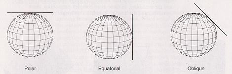
11 Types of Projections Imagine a globe with a light source inside that projects features on the earth s surface onto a flat surface That flat surface can be configured a number of ways as a cylinder, a cone, or a plane

12 an imaginary light is projected onto a developable surface a variety of different projection models exist
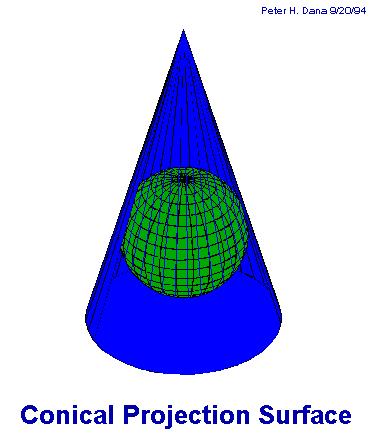
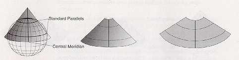
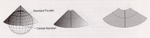
13 cone as developable surface secant cone tangent cone


14 cylinder as developable surface tangent cylinders

15 plane as developable surface

16

17 Map projections always introduce error and distortion

18 Map projections always introduce error and distortion
19 Map projections always introduce error and distortion
20 Map projections always introduce error and distortion Distortion may be minimized in one or more of the following properties: o Shape conformal o Distance equidistant o Direction true direction o Area equal area
21 Exactly what are map projections? Sets of mathematical equations that convert coordinates from one system to another (x, y) f f (x, y) input unprojected angles (lat/long) output projected Cartesian coordinates
22 How do projections work on a programmatic level? o o o each set of "coordinates" is transformed using a specific projection equation from one system to another angular measurements can be converted to Cartesian coordinates one set of Cartesian coordinates can be converted to a different measurement framework Projection, zone, datum (units) X Y geographic, NAD27 (decimal degrees) UTM, Zone 10, NAD27 (meters) State Plane, WA-N, NAD83 (feet)

23 Geographic projection

24 Examples of different projections Albers (Conic) Shape Area Direction Distance Shape along the standard parallels is accurate and minimally distorted in the region between the standard parallels and those regions just beyond. The 90-degree angles between meridians and parallels are preserved, but because the scale along the lines of longitude does not match the scale along lines of latitude, the final projection is not conformal. All areas are proportional to the same areas on the Earth. Locally true along the standard parallels. Distances are best in the middle latitudes. Along parallels, scale is reduced between the standard parallels and increased beyond them. Along meridians, scale follows an opposite pattern.
25
. Distortion is severe near the poles of the normal aspect or 90 from the central line in the transverse and oblique aspects.")
26 Examples of different projections Lambert Azimuthal Equal Area (Planar) Shape Area Direction Distance Shape is true along the standard parallels of the normal aspect (Type 1), or the standard lines of the transverse and oblique aspects (Types 2 and 3). Distortion is severe near the poles of the normal aspect or 90 from the central line in the transverse and oblique aspects. There is no area distortion on any of the projections. Local angles are correct along standard parallels or standard lines. Direction is distorted elsewhere. Scale is true along the Equator (Type 1), or the standard lines of the transverse and oblique aspects (Types 2 and 3). Scale distortion is severe near the poles of the normal aspect or 90 from the central line in the transverse and oblique aspects.


27

28 Examples of different projections Mercator (Cylindrical) Shape Area Direction Distance Conformal. Small shapes are well represented because this projection maintains the local angular relationships. Increasingly distorted toward the polar regions. For example, in the Mercator projection, although Greenland is only one-eighth the size of South America, Greenland appears to be larger. Any straight line drawn on this projection represents an actual compass bearing. These true direction lines are rhumblines, and generally do not describe the shortest distance between points. Scale is true along the Equator, or along the secant latitudes.

29

30 Examples of different projections Miller (Cylindrical) Shape Area Direction Distance Minimally distorted between 45th parallels, increasingly toward the poles. Land masses are stretched more east to west than they are north to south. Distortion increases from the Equator toward the poles. Local angles are correct only along the Equator. Correct distance is measured along the Equator.
31
32 Examples of different projections Mollweide (Pseudocylindrical) Shape Shape is not distorted at the intersection of the central meridian and latitudes 40 44' N and S. Distortion increases outward from these points and becomes severe at the edges of the projection. Area Equal-area. Direction Local angles are true only at the intersection of the central meridian and latitudes 40 44' N and S. Direction is distorted elsewhere. Distance Scale is true along latitudes 40 44' N and S. Distortion increases with distance from these lines and becomes severe at the edges of the projection.
33

34 Examples of different projections Orthographic Shape Area Direction Distance Minimal distortion near the center; maximal distortion near the edge. The areal scale decreases with distance from the center. Areal scale is zero at the edge of the hemisphere. True direction from the central point. The radial scale decreases with distance from the center and becomes zero on the edges. The scale perpendicular to the radii, along the parallels of the polar aspect, is accurate.

35
36 Coordinate Systems
37 Coordinates Features on spherical surfaces are not easy to measure Features on planes are easy to measure and calculate distance angle area Coordinate systems provide a measurement framework

38 Coordinates Lat/long system measures angles on spherical surfaces 60º east of PM 55º north of equator
39 Lat/long values are NOT Cartesian (X, Y) coordinates constant angular deviations do not have constant distance deviations 1 of longitude at the equator 1 of longitude near the poles
40 Coordinate systems Examples of different coordinate/projection systems State Plane Universal Transverse Mercator (UTM)
41 State Plane Coordinate systems Codified in 1930s Use of numeric zones for shorthand SPCS (State Plane Coordinate System) FIPS (Federal Information Processing System) Uses one or more of 3 different projections: Lambert Conformal Conic (east-west orientation ) Transverse Mercator (north-south orientation) Oblique Mercator (nw-se or ne-sw orientation)
42 Coordinate systems
 False Northing (m) PA_N 5126 3701 Lambert Conformal Conic 40 10 00 40 53 00-77 45 00 47 00 00 600000 0 PA_S 5151 3702 Lambert")
43 Pennsylvania State Plane zone definitions Zone SPCS Zone # FIPS Zone # Projection 1st Std. Parallel 2nd Std. Parallel Central Meridian Origin False Easting (m) False Northing (m) PA_N Lambert Conformal Conic PA_S Lambert Conformal Conic projection.ppt 42
 false eastings Y-0 set at south pole or")
44 Coordinate systems Universal Transverse Mercator (UTM) Based on the Transverse Mercator projection 60 zones (each 6 wide) false eastings Y-0 set at south pole or equator


45 Coordinate systems Every place on earth falls in a particular zone

46 Universal Transverse Mercator (UTM) Pennsylvania is has 2 UTM Zones (18 and 19)
47 Datum's
48 Datum's A system that allows us to place a coordinate system on the earth s surface Initial point Secondary point Model of the earth Known geoidal separation at the initial point
49 Datum's Commonly used datum's in North America North American Datum of 1927 (NAD27) NAD83 World Geodetic System of 1984 (WGS84)
50 Scale
51 Scale Map measurement and true ground measurement ( 24,000" )*( 1' ) = 50' 0.025" * 1" 12" A 1/40th in line on a 1:24,000 scale map is 50 ft on the ground ( 2,000,000) *( 1cm )*( 1" )*( 1' ) = 1,969' 0.30mm* 1 10mm 2.54cm 12" A.30 mm line on a 1:200,000 scale map is almost 2,000 ft on the ground
52 Map Scale Scale refers to the relationship or ratio between a distance on a map and the distance on the earth it represents. Maps should display accurate distances and locations, and should be in a convenient and usable size. Map scales can be expressed as representative fraction or ratio: 1:100,000 or 1/100,000 graphical scale: verbal-style scale: 1 inch in map equal to 2000 feet on the ground or 1 inch = 2000 feet
53 GIS is Scale less In GIS, the scale can be easily enlarged and reduced to any size that is appropriate. However, if we get farther and farther from the original scale of the layer, problems appear: details no appear in an enlarged map too dense in a reduced map
54 Scale in attention The scale of the original map determines the largest map scale at which the data can be used. Road map 1:50,000 scale can NOT be used accurately at the 1:24,000 scale. Water coverage at 1:250,000 scale can NOT be used accurately at the 1:50,000 scale

55 Scale in attention Data from different sources and scales can vary widely 1:100,000 scale data from USGS DLG

56 Scale in attention Data from different sources and scales can vary widely 1:1,000,000 scale data from DCW (DMA)

57 Scale in attention Data from different sources and scales can vary widely 1:2,000,000 scale data from USGS DLG
58 Beware of scale statements one to two-hundred : does this mean one inch on the map equals 200 inches on the ground? or one inch on the map equals 200 feet on the ground?
59 Projections in ArcGIS
60 Projections in ArcGIS All geographic datasets have a GCS Many also have a PCS Unprojected (GCS) data is generally inappropriate for GIS analyses The first layer added to ArcMap defines the projection and datum for the data frame. This can be changed in the data frame properties. All subsequent layers are projected on-the-fly (if necessary) to match the data frame projection. The GCS of the layer must match the data frame or a transformation is required.
61 How does ArcGIS handle map projections in data frames? o Project data frames to see or measure features under different projection parameters o Applying a projection on a data frame projects data on the fly. o ArcGIS s data frame projection equations can handle any input projection. o However, sometimes on-the-fly projected data do not properly overlap.


62 Applying a projection to a data frame is like putting on a pair of glasses You see the map differently, but the data have not changed
63 How does ArcGIS handle map projections for data? Projecting data creates a new data set on the file system Data can be projected so that incompatibly projected data sets can be made to match. ArcGIS s projection engine can go in and out of a large number of different projections, coordinate systems, and datums.
64 Stored in: Projection Metadata A.prj file for shapefiles A table in geodatabases A prj.adf in coverages and grids A header for other raster formats. This can be either a separate file (.hdr,.tifw) or embedded in the raster file itself Data have a GCS and may have a PCS even if the metadata is missing. These data have an unknown coordinate system.
 and ArcCatalog (Description")
65 Projection Metadata CS information can be viewed in ArcMap (layer properties>source tab) and ArcCatalog (Description tab)
66 Data with Unknown Coordinate Systems Cannot be projected on-the-fly Will generate a warning when added to ArcMap Layer will be added, but may not align with other data Can be fixed with Define Projection tool if you know the CS If you don t, you can try: contacting the source adding the layer to a map with a known CS. If the new layer is registered with existing layers, it is the same CS.
67 Projecting Raster Data Because projections cause distortions in size and shape, and raster data must have square cells, cells in projected rasters represent different areas on the surface of the earth Resampling is used to assign values to projected cells. Nearest neighbor is fastest and must be used for categorical data like land cover Bilinear interpolation uses a weighted distance average of surrounding cells. Smooths values moderately, useful for continuous data like elevation Cubic convolution fits a curve through surrounding points. Can smooth data significantly and is slower
68 Map Units vs. Display Units Coordinates of the dataset are stored in map units. Geographic generally uses decimal degrees, while a PCS will usually use meters or feet. Map units can only be changed by changing the CS of the data (Project tool). Display units are independent of map units and are set in the data frame properties. ArcMap reports coordinate values and measurements in display units.
69 Points to Remember Choose a PCS for each project. When new data is acquired, be sure it is in that PCS or convert it using the Project tool. It is best not to rely on projection on-the-fly in ArcMap. It is especially important to have all data in the same PCS when doing analyses. Try and avoid changing the CS of raster data Use the Project tool to change the CS of data, but use the Define Projection tool to add metadata about the CS CS should be defined for all spatial data
Georeferencing. Place names Postal addresses Postal codes Coordinate systems (lat/long, UTM, etc.)
") Georeferencing Georeferencing Used to describe the act of assigning locations to data or information Certain requirements include that they are: unique, have shared meaning, and are persistent through
Georeferencing Georeferencing Used to describe the act of assigning locations to data or information Certain requirements include that they are: unique, have shared meaning, and are persistent through
What is a Map Projection?
 What is a Map Projection? It is how we represent a three dimensional Earth on a flat piece of paper However The process of transferring information from the Earth to a map causes every projection to distort
Intro to GIS Fall 2010 Georeferencing & Map Projections
 Intro to GIS Fall 2010 Georeferencing & Map Projections SHAPE OF THE EARTH Earth's Shape Geoid: shape of earth minus topographic features (irregular due to local variations in gravity) Ellipsoid: elongated
Map projections. Rüdiger Gens
 Rüdiger Gens Coordinate systems Geographic coordinates f a: semi-major axis b: semi-minor axis Geographic latitude b Geodetic latitude a f: flattening = (a-b)/a Expresses as a fraction 1/f = about 300
Lecture 4. Coordinate Systems & Projections
 Lecture 4 Coordinate Systems & Projections Outline Geodesy Geoids Ellipsoids Geographic Coordinate Systems Magnetic North vs. True North Datums Projections Applying Coordinate Systems and Projections Why
WHERE ARE YOU? Maps & Geospatial Concepts Fall 2012
 WHERE ARE YOU? Maps & Geospatial Concepts Fall 2012 Where are you? Relative location I m at school Absolute Location 45 26 18.07 122 43 50.78 Datums Datums A reference surface of the Earth Used as the
Map Projections. Displaying the earth on 2 dimensional maps
 Map Projections Displaying the earth on 2 dimensional maps Map projections Define the spatial relationship between locations on earth and their relative locations on a flat map Are mathematical expressions
GIST 3300 / Geographic Information Systems. Last Time. Today
 GIST 3300 / 5300 Last Time Ellipsoids and Datums Today Map Projections Map Projections Today we will build on the concepts of Geographic Coordinate Systems, Ellipsoids and Datums and add the concepts of
WHERE ARE YOU? Maps & Geospatial Concepts Fall 2015
 WHERE ARE YOU? Maps & Geospatial Concepts Fall 2015 Where are you? Relative location I m at school Absolute Location 45 26 18.07 122 43 50.78 Where is Boston? Introducing Geodesy, Ellipsoids & Geoids Geodesy
Welcome to Lesson 4. It is important for a GIS analyst to have a thorough understanding of map projections and coordinate systems.
 Welcome to Lesson 4. It is important for a GIS analyst to have a thorough understanding of map projections and coordinate systems. A GIS without coordinates would simply be a database like Microsoft Excel
EnvSci360 Computer and Analytical Cartography
 EnvSci360 Computer and Analytical Cartography Lecture 3 Geodesy Map Projections, Datums, and Coordinate Systems 1 Geodesy The science of measuring and representing the shape and size of the earth, and
Georeferencing, Map Projections, Cartographic Concepts. -Coordinate Systems -Datum
 Georeferencing, Map Projections, Cartographic Concepts -Map Projections -Coordinate Systems -Datum Map projection is "the process of systematically transforming positions on the Earth's spherical surface
Geographic coordinate systems
 1 Geographic coordinate systems In this chapter you ll learn about longitude and latitude. You ll also learn about the parts that comprise a geographic coordinate system including Spheres and spheroids
Map Projections & Coordinate Systems
 Map Projections & Coordinate Systems 9/7/2017 1 Why? Laying the Earth Flat Need convenient means of measuring and comparing distances, directions, areas, shapes. Traditional surveying instruments measure
2. GETTING STARTED WITH GIS
 2. GETTING STARTED WITH GIS What are geographic information systems and what are they used for? ArcGIS: ArcMap, ArcCatalog and ArcToolbox Vector data vs. raster data vs. attribute tables Polygons, polylines,
NR402 GIS Applications in Natural Resources Lesson 4 Map Projections
 NR402 GIS Applications in Natural Resources Lesson 4 Map Projections From http://www.or.blm.gov/gis/ 1 Geographic coordinates Coordinates are expressed as Latitude and Longitude in Degrees, Minutes, Seconds
This week s topics. Week 6. FE 257. GIS and Forest Engineering Applications. Week 6
 FE 257. GIS and Forest Engineering Applications Week 6 Week 6 Last week Chapter 8 Combining and splitting landscape features and merging GIS databases Chapter 11 Overlay processes Questions? Next week
REFERENCING COORDINATE SYSTEMS MAP PROJECTIONS GEOREFERENCING
 GIS in Ecology SPATIAL REFERENCING COORDINATE SYSTEMS MAP PROJECTIONS GEOREFERENCING : :1 Where on earth? Early mapmakers recognized the need for a system that could locate features on the earth's surface.
Map projections. Rüdiger Gens
 Rüdiger Gens 2 Outline! Relevant terms! Why map projections?! Map projection categories " Projection surfaces " Features preserved from distortions! Map projection examples! Right choice Relevant terms!
Lesson 5: Map Scale and Projections
 Organizing Data and Information Lesson 5: Map Scale and Projections Map Scales Projections Information can be organized as lists, numbers, tables, text, pictures, maps, or indexes. Clusters of information
Understanding Projections for GIS
 Presented by John Schaeffer Juniper GIS Services, Inc. This PowerPoint is available at JuniperGIS.com Presentation Objectives To understand basic concepts on projections and coordinate systems for the
Dr. ABOLGHASEM AKBARI Faculty of Civil Engineering & Earth Resources, University Malaysia Pahang (UMP)
") Workshop on : Dr. ABOLGHASEM AKBARI Faculty of Civil Engineering & Earth Resources, University Malaysia Pahang (UMP) 14-15 April 2016 Venue: Tehran, Iran GIS definitions GIS: A simplified view of the real
Workshop on : Dr. ABOLGHASEM AKBARI Faculty of Civil Engineering & Earth Resources, University Malaysia Pahang (UMP) 14-15 April 2016 Venue: Tehran, Iran GIS definitions GIS: A simplified view of the real
Introduction to Geographic Information Science. Updates/News. Last Lecture. Geography 4103 / Map Projections and Coordinate Systems
 Geography 4103 / 5103 Introduction to Geographic Information Science Map Projections and Coordinate Systems Updates/News Thursday s lecture Reading discussion 1 find the readings online open questions,
Applied Cartography and Introduction to GIS GEOG 2017 EL. Lecture-1 Chapters 1 and 2
 Applied Cartography and Introduction to GIS GEOG 2017 EL Lecture-1 Chapters 1 and 2 What is GIS? A Geographic Information System (GIS) is a computer system for capturing, storing, querying, analyzing and
Outline. Shape of the Earth. Geographic Coordinates (φ, λ, z) Ellipsoid or Spheroid Rotate an ellipse around an axis. Ellipse.
 Ellipsoid or Spheroid Rotate an ellipse around an axis. Ellipse.") Map Projections Outline Geodesy and map projections Prof. D. Nagesh Kumar Department of Civil Engineering Indian Institute of Science Bangalore 560 012, India http://www.civil.iisc.ernet.in/~nagesh Shape
Map Projections Outline Geodesy and map projections Prof. D. Nagesh Kumar Department of Civil Engineering Indian Institute of Science Bangalore 560 012, India http://www.civil.iisc.ernet.in/~nagesh Shape
Lab #3 Map Projections.
 Lab #3 Map Projections http://visual.merriam-webster.com/images/earth/geography/cartography/map-projections.jpg Map Projections Projection: a systematic arrangement of parallels and meridians on a plane
Shape e o f f the e Earth
 1 Coordinate Systems & Projections Coordinate Systems Two map layers are not going to register spatially unless they are based on the same coordinate system. 2 Contents Shape of the earth Datum Projections
How does an ellipsoid differ from a sphere in approximating the shape and size of the Earth?
 Chapter 02 Test Bank Worksheet Questions 1. What is a map projection? Topic: Map Projection 2. How does an ellipsoid differ from a sphere in approximating the shape and size of the Earth? Topic: Ellipsoid
Lecture 2. Map Projections and GIS Coordinate Systems. Tomislav Sapic GIS Technologist Faculty of Natural Resources Management Lakehead University
 Lecture 2 Map Projections and GIS Coordinate Systems Tomislav Sapic GIS Technologist Faculty of Natural Resources Management Lakehead University Map Projections Map projections are mathematical formulas
Map Projections. What does the world look like? AITOFF AZIMUTHAL EQUIDISTANT BEHRMANN EQUAL AREA CYLINDRICAL
 Map Projections What does the world look like? AITOFF AZIMUTHAL EQUIDISTANT BEHRMANN EQUAL AREA CYLINDRICAL 1 CYLINDRICAL EQUAL AREA BONNE CRASTER PARABOLIC 2 ECKERT I ECKERT III ECKERT V There are many
ch02.pdf chap2.pdf chap02.pdf
 Introduction to Geographic Information Systems 8th Edition Karl Solutions Manual Full Download: http://testbanklive.com/download/introduction-to-geographic-information-systems-8th-edition-karl-solutions-manu
The Wildlife Society Meet and Greet. Come learn about what the UNBC Student Chapter of TWS is all about!
 Georeferencing I GEOG 300, Lecture 4 Dr. Anthony Jjumba 1 The Wildlife Society Meet and Greet Quiz Come learn about what the UNBC Student Chapter of TWS is all about! 5:30 7:30 PM, Wednesday September
Georeferencing. datum. projection. scale. The next few lectures will introduce you to these elements. on the Earth, you ll need to understand how
 Georeferencing GOAL: To assign a location to all the features represented in our geographic information data In order to do so, we need to make use of the following elements: ellipsoid/geoid To determine
Importance of Understanding Coordinate Systems and Map Projections.
 Importance of Understanding Coordinate Systems and Map Projections. 1 It is extremely important that you gain an understanding of coordinate systems and map projections. GIS works with spatial data, and,
Working with georeferenced data. What is georeferencing? Coordinate Systems. Geographic and Projected Coordinate System
 GIS501 Fundamentals of Geographical Information Systems (GIS) Coordinate Systems Working with georeferenced data What is georeferencing? Geographically referenced data which is, in some way, referenced
Map Projections 2/4/2013. Map Projections. Rhumb Line (Loxodrome) Great Circle. The GLOBE. Line of constant bearing (e.g., 292.
 Great Circle. The GLOBE. Line of constant bearing (e.g., 292.") The GLOBE ADVANTAGES Directions True Distances True Shapes True Area True DISADVANTAGES Very small scale with little detail. Costly to reproduce and update. Difficult to carry around. Bulky to store. FACTS
The GLOBE ADVANTAGES Directions True Distances True Shapes True Area True DISADVANTAGES Very small scale with little detail. Costly to reproduce and update. Difficult to carry around. Bulky to store. FACTS
Coordinate Systems. Location on earth is defined by coordinates
 Coordinate Systems We think of the earth as a sphere It is actually a spheroid (ellipsoid), slightly larger in radius at the equator than at the poles Shape of the Earth Location on earth is defined by
Plane coordinates ~~~~~~~~~~
 Coordinate Systems & Map Projections Geographic coordinates A Basic Introduction to Coordinate Systems & Map Projections Latitude & longitude Angles Parallels & meridians Lines Plane coordinates ~~~~~~~~~~
GEOL 452/552 - GIS for Geoscientists I. Lecture 15
 GEOL 452/552 - GIS for Geoscientists I Lecture 15 Lecture Plan Midterm Multiple choice part graded (+ solutions) Jump to Ch. 11 for one lecture Coordinate systems Projections, datums, spheroids Unprojected
Map Projections & Coordinate Systems 9/10/2013. Why? M. Helper GEO327G/386G, UT Austin 2. M. Helper GEO327G/386G, UT Austin 4
 Map Projections & Coordinates Laing the earth flat Wh? Need convenient means of measuring and comparing distances, directions, areas, shapes. Traditional surveing instruments measure in meters or feet,
Map Projections & Coordinate Systems 9/7/2017
 Map Projections & Coordinate Sstems Laing the Earth Flat Wh? Need convenient means of measuring and comparing distances, directions, areas, shapes. Traditional surveing instruments measure in meters or
1. Geospatial technology rarely links geospatial data to nonspatial data. a. True *b. False
 Chapter 2 Where in the Geospatial World Are You? 1. Geospatial technology rarely links geospatial data to nonspatial data. 2. For geospatial technology to work, every location on Earth must be: a. inhabited
GEOGRAPHIC COORDINATE SYSTEMS
 GEOGRAPHIC COORDINATE SYSTEMS Introduction to GIS Winter 2015 What is Georeferencing? Used to establish a location on the Earth s surface 1 st order polynomial transformation Georeferencing toolbar What
Overview key concepts and terms (based on the textbook Chang 2006 and the practical manual)
") Introduction Geo-information Science (GRS-10306) Overview key concepts and terms (based on the textbook 2006 and the practical manual) Introduction Chapter 1 Geographic information system (GIS) Geographically
Introduction Geo-information Science (GRS-10306) Overview key concepts and terms (based on the textbook 2006 and the practical manual) Introduction Chapter 1 Geographic information system (GIS) Geographically
The Elements of GIS. Organizing Data and Information. The GIS Database. MAP and ATRIBUTE INFORMATION
 GIS s Roots in Cartography Getting Started With GIS Chapter 2 Dursun Z. Seker MAP and ATRIBUTE INFORMATION Data (numbers and text) store as files refer to them collectively as a database gather inform.
Geography 281 Map Making with GIS Project Eight: Comparing Map Projections
 Geography 281 Map Making with GIS Project Eight: Comparing Map Projections In this activity, you will do a series of projection comparisons using maps at different scales and geographic extents. In this
Map Projections & Coordinate Systems 1/25/2018
 Map Projections & Coordinate Sstems Laing the Earth Flat How? Projections transformation of curved earth to a flat map; sstematic rendering of the lat. & lon. graticule to rectangular coordinate sstem.
How can we project a 3D globe onto a 2D display? - Ellipsoids and Datums deal with earth non-sphericity
 Map projections How can we project a 3D globe onto a 2D display? - Ellipsoids and Datums deal with earth non-sphericity http://www.mapovasbirka.cz/english/index_eng.html The world could be mapped like
Modern Navigation. Thomas Herring
 12.215 Modern Navigation Thomas Herring Today s class Map Projections: Why projections are needed Types of map projections Classification by type of projection Classification by characteristics of projection
Lecture 10-14: Map Projections and Coordinate System
 URP 1281 Surveying and Cartography Lecture 10-14: Map Projections and Coordinate System December 27, 2015 Course Teacher: Md. Esraz-Ul-Zannat Assistant Professor Department of Urban and Regional Planning
The Nature of Spatial Data. Keith C. Clarke Geography UCSB
 The Nature of Spatial Data Keith C. Clarke Geography UCSB Geographic primitives G = g (x, y, z, s, A, t) [x, y, z] = f(λ, φ, d) Geography also highly dependent upon model First, the datum (d) Models of
GEOREFERENCING, PROJECTIONS Part I. PRESENTING DATA Part II
 Week 7 GEOREFERENCING, PROJECTIONS Part I PRESENTING DATA Part II topics of the week Georeferencing Coordinate systems Map Projections ArcMap and Projections Geo-referencing Geo-referencing is the process
Referencing map features: Coordinate systems and map projections
 Referencing map features: Coordinate systems and map projections Coordinate systems and map projections if we want to integrate geographic data from many different sources, we need to use a consistent
1/28/16. EGM101 Skills Toolbox. Oblate spheroid. The shape of the earth Co-ordinate systems Map projections. Geoid
 EGM101 Skills Toolbox Oblate spheroid The shape of the earth Co-ordinate systems Map projections The geoid is the shape that the surface of the oceans would take under the influence of Earth's gravitation
Full file at https://fratstock.eu
 Full file at https://fratstockeu Chapter 1 to Exercises 1 1 The feature data set is called Transportation It has two feature classes, majroads and interstates Method: Use the Add Data button to look at
Control Surveys and Coordinate Systems
 Control Surveys and Coordinate Systems The Earth is Round Basic Shape of the Earth: Oblate Spheroid of Revolution The length of the equatorial axis is approximately 27 miles greater than the polar axis.
Map Projections (Part 1)
") 1 Earth is a round, maps are not. Four projection families. Equivalent (Equal Area) projections Preserves relative areas Commonly used for thematic maps Ex: Albers Conformal projections Preserve angles,
1 Earth is a round, maps are not. Four projection families. Equivalent (Equal Area) projections Preserves relative areas Commonly used for thematic maps Ex: Albers Conformal projections Preserve angles,
IDENTIFYING THE TYPE OF COORDINATE SYSTEM FOR DATA USING ARCMAP
 CHAPTER 1 IDENTIFYING THE TYPE OF COORDINATE SYSTEM FOR DATA USING ARCMAP I got a parcel shapefile from the county, but it doesn t line up with my other data in ArcMap. My boss told me to make a map using
Projections Part I - Categories and Properties James R. Clynch February 2006
 I. Introduction and References Projections Part I - Categories and Properties James R. Clynch February 2006 The world is, approximately, a sphere. Maps are flat. Making maps requires some method of putting
Coordinate systems and transformations in action. Melita Kennedy and Keera Morrish
 Coordinate systems and transformations in action Melita Kennedy and Keera Morrish Objectives Coordinate systems - Geographic versus projected - Project considerations - Gotchas Identifying an unknown coordinate
Chapter 3 Models of the Earth. 3.1 Finding Locations on the Earth. 3.1 Objectives
 Chapter 3 Models of the Earth 3.1 Finding Locations on the Earth 3.1 Objectives Explain latitude and longitude. How can latitude and longitude be used to find locations on Earth? How can a magnetic compass
Laboratory Topic 4: Projections and Geo-Positioning in ArcGIS [ LAEP/GEOG c188 ]
![Laboratory Topic 4: Projections and Geo-Positioning in ArcGIS [ LAEP/GEOG c188 ]](/thumbs/81/82687491.jpg "Laboratory Topic 4: Projections and Geo-Positioning in ArcGIS [ LAEP/GEOG c188 ]") Laboratory Topic 4: Projections and Geo-Positioning in ArcGIS 10.4.1 - [ LAEP/GEOG c188 ] Projections in ArcGIS 10.4.1 In this tutorial you will learn to identify the Projection and Datum of a dataset,
Laboratory Topic 4: Projections and Geo-Positioning in ArcGIS 10.4.1 - [ LAEP/GEOG c188 ] Projections in ArcGIS 10.4.1 In this tutorial you will learn to identify the Projection and Datum of a dataset,
Projections & GIS Data Collection: An Overview
 Projections & GIS Data Collection: An Overview Projections Primary data capture Secondary data capture Data transfer Capturing attribute data Managing a data capture project Geodesy Basics for Geospatial
12/26/2012. Geographic Information Systems * * * * GIS (... yrezaei
 ( - Geographic Information Systems ( ( 1 2 3 Information System Data base DB IS IS DB (Knowledge ( ( (System (Information System - (Georefrence Analysis Data + Knowledge ======== Information 4 5 ( < 10%
Geo Referencing & Map projections CGI-GIRS 0910
 Geo Referencing & Map projections CGI-GIRS 0910 Where are you? 31UFT8361 174,7 441,2 51 58' NB 5 40' OL 2/60 Who are they? 3/60 Do geo data describe Earth s phenomena perfectly? Georeference systems ellipsoid
GPS Remote Sensing. GIS Photogrammetry. GEODESY Equipment (total station) CARTOGRAPHY Survey Software. Map Projection Coordinate Systems
 CARTOGRAPHY Survey Software. Map Projection Coordinate Systems") GPS Remote Sensing GIS Photogrammetry GEODESY Equipment (total station) CARTOGRAPHY Survey Software Map Projection Coordinate Systems 1 Coordinate Systems, Datum and Map Projection Dr. Maher A. El-Hallaq
GPS Remote Sensing GIS Photogrammetry GEODESY Equipment (total station) CARTOGRAPHY Survey Software Map Projection Coordinate Systems 1 Coordinate Systems, Datum and Map Projection Dr. Maher A. El-Hallaq
Lab#3: GIS Projections and Coordinate Systems. Start Arcmap and create a data frame for each of the above coordinate systems.
 NRM338 Fall 2017 Lab#3 Page#1 of 18 In this lab, you will Lab#3: GIS Projections and Coordinate Systems 1) Define the geographic coordinate system of two GIS themes. 2) Determine the geographic coordinates
Georeferencing. Geography is the key to linking attributes. Georeferencing is the key to geography.
 Georeferencing Geography is the key to linking attributes. Georeferencing is the key to geography. Why georeferencing? Many reasons for having georeferences Many different approaches to georeferencing
Spatial Data, 16 th Century Dutchmen, GPS and GIS. Martin Charlton, National Centre for Geocomputation National University of Ireland Maynooth
 Spatial Data, 16 th Century Dutchmen, GPS and GIS Martin Charlton, National Centre for Geocomputation National University of Ireland Maynooth Maps as truth Maps are cultural artifacts, comparable in history
Coordinate Systems and Datum Transformation in ArcGIS. Brittney White and Melita Kennedy
 Coordinate Systems and Datum Transformation in ArcGIS Brittney White and Melita Kennedy Where is my data? Problem Horizontal Vertical Projections Transformations Horizontal coordinate systems Geographic
Geo Referencing & Map projections CGI-GIRS 0910
 Geo Referencing & Map projections CGI-GIRS 0910 Where are you? 31UFT8361 174,7 441,2 51 58' NB 5 40' OL 2/60 Who are they? 3/60 Do geo data describe Earth s phenomena perfectly? Georeference systems ellipsoid
Notes on Projections Part II - Common Projections James R. Clynch February 2006
 Notes on Projections Part II - Common Projections James R. Clynch February 2006 I. Common Projections There are several areas where maps are commonly used and a few projections dominate these fields. An
Lecture Plan. GEOL 452/552 - GIS for Geoscientists I. Why use Projections? Lecture 15 - chapter 11. Different types of Projections
 GEOL 452/552 - GIS for Geoscientists I Lecture 15 - chapter 11 Lecture Plan Ch. 11, one lecture Coordinate systems Projection, Datums, Dpheroid Unprojected (geographic) coord. syst., UTM On the fly projection
Fri. Jan. 26, Demonstration of QGIS with GPS tracks. Types of data, simple vector (shapefile) formats
 formats") Fri. Jan. 26, 2018 Demonstration of QGIS with GPS tracks Types of data, simple vector (shapefile) formats Map projections, Coordinate Reference Systems Demonstration of QGIS with geologic map 1 Raster
Fri. Jan. 26, 2018 Demonstration of QGIS with GPS tracks Types of data, simple vector (shapefile) formats Map projections, Coordinate Reference Systems Demonstration of QGIS with geologic map 1 Raster
Analytical and Computer Cartography Lecture 3: Review: Coordinate Systems
 Analytical and Computer Cartography Lecture 3: Review: Coordinate Systems Geographic Coordinates NAD83 NAD27 remained in use until the earthcentered international GRS80 was complete (Geodetic Reference
Terms GIS GPS Vector Data Model Raster Data Model Feature Attribute Table Point Line Polygon Pixel RGB Overlay Function
 FINAL REVIEW FOR GIS (2016) PRACTICAL COMPONENT The first 40 mins of the exam will be open book and will require you to make a map using all the techniques learned over the semester. This map will be e-mailed
Geographers Perspectives on the World
 What is Geography? Geography is not just about city and country names Geography is not just about population and growth Geography is not just about rivers and mountains Geography is a broad field that
Watershed Sciences 4930 & 6920 GEOGRAPHIC INFORMATION SYSTEMS
 Watershed Sciences 4930 & 6920 GEOGRAPHIC INFORMATION SYSTEMS WEEK TWO Lecture PROJECTIONS Joe Wheaton Some of slides in this lecture adapted from content in Paul Bolstad s Fundamentals of GIS HOUSEKEEPING
Solving the "Grid to Ground Problem" with Custom Coordinate Systems CV327-6 About the Speaker:
 Solving the "Grid to Ground Problem" with Custom Coordinate Systems Richard Sincovec, LSI Director of Technology, Edward James Surveying President, Quux Software CV327-6 Grid projections such as the State
2. Which geometric model has been used at some time to describe the earth? a. Sphere b. Oblate ellipsoid c. Flat disk. d. Geoid e.
 01 02 03 04 05 06 07 08 09 10 11 12 13 14 15 16 17 18 19 20 21 22 23 24 25 26 27 28 29 30 31 32 33 34 35 36 37 38 39 40 41 42 43 44 45 46 47 48 49 50 Geography 12 Sample Mid-Term Examination Before you
A PRIMER ON COORDINATE SYSTEMS Commonly Used in Michigan
 A PRIMER ON COORDINATE SYSTEMS Commonly Used in Michigan David P. Lusch, Ph.D., GISP Department of Geography Remote Sensing & GIS Research and Outreach Services Group Michigan State University September,
GST 101: Introduction to Geospatial Technology Lab 3 - Understanding Coordinate Systems and Map Projections
 GST 101: Introduction to Geospatial Technology Lab 3 - Understanding Coordinate Systems and Map Projections Objective Explore and Understand Coordinate Systems and Map Projections Document Version: 3/3/2015
Coordinate Systems and Map James Frew ESM 263 Winter
 Coordinate Systems and Map Projec@ons 1 Outline Introduc@on La@tude and longitude Projec@ons and coordinate systems Placenames Postal addresses and postal codes Linear referencing systems Cadasters Conver@ng
Data Set Projection Checklist
 1 of 6 12/20/2012 12:38 PM Data Set Projection Checklist There are two projections/coordinate systems you must worry about: 1. 2. That of your map. You can pick this to be whatever you want, and your GIS
An ESRI Technical Paper June 2007 Understanding Coordinate Management in the Geodatabase
 An ESRI Technical Paper June 2007 Understanding Coordinate Management in the Geodatabase ESRI 380 New York St., Redlands, CA 92373-8100 USA TEL 909-793-2853 FAX 909-793-5953 E-MAIL info@esri.com WEB www.esri.com
GST 104: Cartographic Design Lab 2: Exploring Coordinate Systems and Map Projections
 GST 104: Cartographic Design Lab 2: Exploring Coordinate Systems and Map Projections Objective Explore and Understand Coordinate Systems and Map Projections Document Version: 2014-05-31 (Beta) Author:
Introduction to Geoinformatics I
 Introduction to Geoinformatics I MAP CONCEPT Definition: 1) A map is a visual representation of an area a symbolic depiction highlighting relationships between elements of that space such as objects, regions,
Coordinate Systems and Datum Transformations in Action
 Esri International User Conference San Diego, CA Technical Workshops Coordinate Systems and Datum Transformations in Action Melita Kennedy, Geri Pepe July 12, 2011 Objectives Coordinate systems - Geographic
Coordinate Systems and Datum Transformations in Action
 Esri International User Conference San Diego, California Technical Workshops July 26, 2012 Coordinate Systems and Datum Transformations in Action Geri Miller Rob Juergens Objectives Coordinate systems
GIS in Management Planning. Lab 2 Coordinate Systems and Map Projections
 GIS in Management Planning Lab 2 Coordinate Systems and Map Projections Tomislav Sapic GIS Technologist Faculty of Natural Resources Management Lakehead University ArcGIS ArcToolbox Projections Functions
Map Projections. Chapter 4 MAP PROJECTION
 Map Projections Chapter 4 Map Projections What is map projection? Why are map projections drawn? What are the different types of projections? Which projection is most suitably used for which area? In this
Ground Truth Annual Conference. Optimized Design of Low Distortion Projections. Michael L. Dennis, RLS, PE
 Arizona Professional Land Surveyors Association 016 Annual Conference Ground Truth Optimized Design of Low Distortion Projections Michael L. Dennis, RLS, PE Version 3 (rev 1), May 016 Design and metadata
Identifying coordinate systems for data using ArcMap
 Chapter 1 Identifying coordinate systems for data using ArcMap I got a parcel shapefile from the county but it doesn t line up with my other data in ArcMap. My boss told me to make a map using ArcMap,
Watershed Sciences 4930 & 6920 GEOGRAPHIC INFORMATION SYSTEMS
 PROJECTS Watershed Sciences 4930 & 6920 GEOGRAPHIC INFORMATION SYSTEMS WEEK THREE Lecture 5 PROJECT DATA/IDEAS, PROJECTIONS (Cont.) & LAB REVIEW Joe Wheaton GUEST LECTURE HOUSEKEEPING: LAB 01 GRADES This
ArcGIS for Applied Economists Session 2
 ArcGIS for Applied Economists Session 2 Mark Westcott LMU Munich June 15, 2015 1 / 31 Topics for this session: Geographic Coordinate Systems Projections Projected Coordinate Systems Geocoding 2 / 31 Some
Navigation. Longitude and Latitude Foundations of Navigation. MTPs:
 Navigation 3.01 Foundations of Navigation References: FTGU pages 177-178, 184-190 Transport Canada Study and Reference Guide Glider Pilot Canada Flight Training Manual Pilot Navigation http://en.wikipedia.org/wiki/transverse_mercator_projection#spherical_transverse_mercator
Boolean Operators and Topological OVERLAY FUNCTIONS IN GIS
 Boolean Operators and Topological OVERLAY FUNCTIONS IN GIS Query asking a question of the attribute data Standard Query Language (SQL) is used to query the data There are 4 basic statements used to get
GIS in Water Resources Fall 2018 Homework #1
 GIS in Water Resources Fall 2018 Homework #1 Goal The goal of this homework is to reinforce the lecture material on Geodesy, Map Projections and Coordinate Systems by having you identify attributes and
Dirty REMOTE SENSING : Lecture 8 A mapping interlude..
 Dirty REMOTE SENSING : Lecture 8 A mapping interlude.. Stuart Green Teagasc Spatial Analysis Group Stuart.green@teagasc.ie Web for the Week: http://electronics.howstuffworks.com/gps.htm http://www.cstars.ucdavis.edu/classes/ers186-w03/lecture17/lecture17.ppt
Displaying Latitude & Longitude Data (XY Data) in ArcGIS
 in ArcGIS") Displaying Latitude & Longitude Data (XY Data) in ArcGIS Created by Barbara Parmenter and updated on 2/15/2018 If you have a table of data that has longitude and latitude, or XY coordinates, you can view
Displaying Latitude & Longitude Data (XY Data) in ArcGIS Created by Barbara Parmenter and updated on 2/15/2018 If you have a table of data that has longitude and latitude, or XY coordinates, you can view