What is Geodesy? Types of Geodesy terrestrial or classical geodesy space geodesy theoretical geodesy
|
|
|
- Emery Tucker
- 6 years ago
- Views:
Transcription
1 What is Geodesy? Geodesy is the study of: The size, shape and motion of the earth The measurement of the position and motion of points on the earth's surface, and The study of the earth's gravity field and its temporal variations Types of Geodesy terrestrial or classical geodesy space geodesy theoretical geodesy
2 Basic Geodesy Facts Geographic/true directions determined by the orientation of the graticule on the earths' surface Magnetic directions must take into account the compass variation (magnetic declination) Great circle arc formed by the intersection of the earth with a plane passing through any two surface points and the center of the earth (equator) Rhumb line, loxodrome or constant azimuth line which makes a fixed angle with all meridians; spirals to pole
3 Horizontal Geodetic Control For North America: Horizontal 200,000+ points marked by bronze survey monument measured on the geoid, adjusted for height to lie on ellipsoid 1833 U.S. Coast & Geodetic Survey established the first baseline; networks of lines triangulated from this baseline 1927 all U.S., Canadian, Mexican networks adjusted and integrated into single network NAD adjustment of 1927 datum to reflect higher accuracy, 2 million + control points, tie to WGS84 ellipsoid - NAD83
4 Vertical Geodetic Control For North America: Vertical beginning in 1856, vertical control point marked by bronze benchmark; level lines created between two endpoints, measured on geoid relative to mean sea level ,000 + miles of level lines in U.S. And Canada (500,000+ control points) adjusted and combined to National Geodetic Vertical Datum of 1929 (NGVD29) 1983 National Vertical Datum of 1983, adjustment of all (now) 388,000+ miles of level lines (NVD83) GPS elevations made relative to GRS80 or WGS84 ellipsoid
5 General Concepts Earth is three- dimensional Map (screen) is 2- D Geographic coordinate system (Datum) locates in 3- D Map Projection converts 3- D to 2- D 3- D to 2- D causes distortions
6 Coordinate Systems Geographical coordinate system: Older of two systems now in general use Uses latitude and longitude to locate positions on the uniformly curved surface of the earth Primary system used for navigation and surveying Rectangular/plane coordinate systems: Used for locating positions on a flat map Evolved from cartesian coordinates

 Not a map")
7 Geographic Coordinate System The Equator and Prime Meridian are the reference points Latitude/ longitude measure angles Latitude (parallels) 0 º -90 º Longitude (meridians) 0 º º Defines locations on 3- D surface Units are degrees (or grads) Not a map projection!
8 Prime Meridians Origin of Longitude lines Usually Greenwich, England Others include Paris, Bogota, Ferro City Meridian Athens, Greece 23 42' " E Bern, Switzerland 7 26' 22".5 E Bogota, Colombia 74 04' 51".3 W Brussels, Belgium 4 22' 04".71 E Ferro (El Hierro) 17 40' 00" W Jakarta, Indonesia ' 27".79 E Lisbon, Portugal 9 07' 54".862 W Madrid, Spain 3 41' 16".58 W Paris, France 2 20' 14".025 E Rome, Italy 12 27' 08".4 E Stockholm, Sweden 18 03' 29".8 E
9 Latitude/ Longitude Not uniform units of measure Meridians converge near Poles 1 longitude at Equator = 111 km at 60 lat. = 55.8 km at 90 lat. = 0 km
10 Decimal Degrees (DD) Decimal degrees are similar to degrees/minutes/seconds (DMS) except that minutes and seconds are expressed as decimal values. Decimal degrees make digital storage of coordinates easier and computations faster.
11 Conversion from DMS to DD: Example coordinate is 37 36' 30" (DMS) Divide each value by the number of minutes or seconds in a degree: 36 minutes =.60 degrees (36/60) 30 seconds = degrees (30/3600) Add up the degrees to get the answer: = DD

12 Cartesian Coordinate System Used for locating positions on a flat map Coordinates tell you how far away from the origin of the axes you are Referenced as (X,Y) pairs In cartography and surveying, the X axis coordinates are known as Eastings, and the Y axis coordinates as Northings. False easting and northings are typically added to coordinate values to keep coordinates in the upper right hand quadrant of the graph positive values

13 3D Cartesian Coordinates Cartesian Coordinates can define a point in space, that is, in three dimensions. To do this, the Z axis must be introduced. This axis will represent a height above above or below the surface defined by the x and y axes.

14 Local 3D Cartesian Coordinates This diagram shows the earth with two local coordinate systems defined on either side of the earth. The Z axis points directly up into the sky. Instead of (X,Y) it is (X,Y,Z)

15 GCS is defined by:
16 The Earth is Not Round First the earth was flat 500 BC Pythagoras declared it was a sphere In the late 1600 s Sir Issac Newton hypothesized that the true shape of the earth was really closer to an ellipse More precisely an Oblate Ellipsoid (squashed at the poles and fat around the equator) And he was right!
17 Shape of the Earth Earth as sphere simplifies math small- scale maps (less than 1: 5,000,000) Earth as spheroid maintains accuracy for larger- scale maps (greater than 1: 1,000,000)

18 Geoid, Ellipsoid & Sphere Geoid - estimates the earth's surface using mean sea level of the ocean with all continents are removed It is an equipotential surface - potential gravity is the same at every point on its surface Ellipsoid - It is a mathematical approximation of the Geoid Authalic Sphere - a sphere that has the same surface area as a particular oblate ellipsoid of revolution representing the figure of the Earth
19 Spheroid or Ellipsoid? What is a Spheroid anyway? An ellipsoid that approximates the shape of a sphere Although the earth is an ellipsoid, its major and minor axes do not vary greatly. In fact, its shape is so close to a sphere that it is often called a spheroid rather than an ellipsoid. ESRI calls it a spheroid but the two can be used interchangeably For most spheroids, the difference between its semi-major axis and its semi-minor axis is less than 0.34 percent.

20 How About a Few Ellipsoids

21 Why Do We Need More Than One Spheroid (Ellipsoid)? The earth's surface is not perfectly symmetrical the semi-major and semi-minor axes that fit one geographical region do not necessarily fit another one.
22 What is the best Ellipsoid for you? After James R. Smith, page 98

23 Shape of the Earth
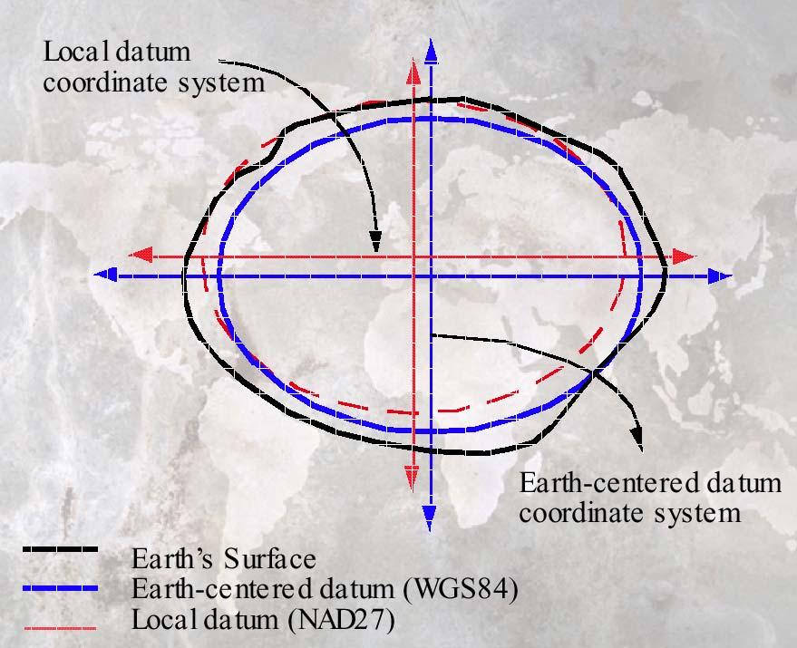
24 Relation of Geoid to Ellipsoid From James R. Smith, page 34
25 Vertical Deflection Important to surveyors Deflection of the Vertical = difference between the vertical and the ellipsoidal normal Described by the component tilts in the northerly and easterly directions.
26 Measuring Height Traditionally measured as height above sea level (Geoid) but is changing due to GPS The distance between the geoid and the spheroid is referred to as the geoidspheroid separation or geoidal undulation Can convert but it is mathematically complex
27 Datums (simplified) Reference frame for locating points on Earth s surface Defines origin & orientation of latitude/ longitude lines Defined by spheroid and spheroid s position relative to Earth s center
28 Geodetic Datums (complex) consists of an initial origin; the azimuth for one line; the parameters of the reference ellipsoid and the geoid separation at the origin. The deflection of the vertical and geoid-spheroid separation are set to zero at an origin point eg Johnson in Australia geodetic latitudes and longitudes depend on both the reference spheroid and coordinate datum often the spheroid is implicitly linked to the datum, so it has become common to use the datum name to imply the spheroid and vice versa eg WGS84 the orientation and scale of the spheroid is defined using further geodetic observations horizontal and vertical (θ, φ, ρ) = (theta, phi, roe) roe describes the distance from the origin, theta is the angle from the XY plane and phi is the angle from the Z axis
29 Creating a Datum Pick a spheroid Pick a point on the Earth s surface All other control points are located relative to the origin point The datum s center may not coincide with the Earth s center
30 Datums, cont. 2 types of datums Earth- centered (WGS84, NAD83) Local (NAD27, ED50)
31

32 Relationship between 2 datums
33 Why so many datums? Many estimates of Earth s size and shape Improved accuracy Designed for local regions
34 North American Datums NAD27 Clarke 1866 spheroid Meades Ranch, KS 1880 s NAD83 GRS80 spheroid Earth- centered datum GPS- compatible
35 North American Datums HPGN / HARN GPS readjustment of NAD83 in the US Also known as NAD91 or NAD93 27 states & 2 territories (42 states in PE) NAD27 (1976) & CGQ77 Redefinitions for Ontario and Quebec NAD83 (CSRS98) GPS readjustment
36 International datums Defined for countries, regions, or the world World: WGS84, WGS72 Regional: ED50 (European Datum 1950) Arc 1950 (Africa) Countries: GDA 1994 (Australia) Tokyo
37 Datum transformations Grid- based NADCON / HARN (US), NT v1 / NT v2 (Canada, Australia, NZ) Equation- based Molodensky, Bursa- Wolf, Coordinate Frame, Three Parameter, Seven Parameter
38 Method accuracies NADCON HARN/ HPGN CNT (NTv1) Seven parameter Three parameter 15 cm 5 cm 10 cm 1-2 m 4-5 m
39 GPS Uses WGS84 datum Other datums are transformed and not as accurate Know what transformation method is being used
Geographic coordinate systems
 1 Geographic coordinate systems In this chapter you ll learn about longitude and latitude. You ll also learn about the parts that comprise a geographic coordinate system including Spheres and spheroids
Boolean Operators and Topological OVERLAY FUNCTIONS IN GIS
 Boolean Operators and Topological OVERLAY FUNCTIONS IN GIS Query asking a question of the attribute data Standard Query Language (SQL) is used to query the data There are 4 basic statements used to get
WHERE ARE YOU? Maps & Geospatial Concepts Fall 2015
 WHERE ARE YOU? Maps & Geospatial Concepts Fall 2015 Where are you? Relative location I m at school Absolute Location 45 26 18.07 122 43 50.78 Where is Boston? Introducing Geodesy, Ellipsoids & Geoids Geodesy
Shape e o f f the e Earth
 1 Coordinate Systems & Projections Coordinate Systems Two map layers are not going to register spatially unless they are based on the same coordinate system. 2 Contents Shape of the earth Datum Projections
EnvSci360 Computer and Analytical Cartography
 EnvSci360 Computer and Analytical Cartography Lecture 3 Geodesy Map Projections, Datums, and Coordinate Systems 1 Geodesy The science of measuring and representing the shape and size of the earth, and
Control Surveys and Coordinate Systems
 Control Surveys and Coordinate Systems The Earth is Round Basic Shape of the Earth: Oblate Spheroid of Revolution The length of the equatorial axis is approximately 27 miles greater than the polar axis.
Understanding Projections for GIS
 Presented by John Schaeffer Juniper GIS Services, Inc. This PowerPoint is available at JuniperGIS.com Presentation Objectives To understand basic concepts on projections and coordinate systems for the
Lecture 4. Coordinate Systems & Projections
 Lecture 4 Coordinate Systems & Projections Outline Geodesy Geoids Ellipsoids Geographic Coordinate Systems Magnetic North vs. True North Datums Projections Applying Coordinate Systems and Projections Why
What is a Map Projection?
 What is a Map Projection? It is how we represent a three dimensional Earth on a flat piece of paper However The process of transferring information from the Earth to a map causes every projection to distort
Map projections. Rüdiger Gens
 Rüdiger Gens Coordinate systems Geographic coordinates f a: semi-major axis b: semi-minor axis Geographic latitude b Geodetic latitude a f: flattening = (a-b)/a Expresses as a fraction 1/f = about 300
Georeferencing. Where on earth are we? Critical for importing and combining layers for mapping
 Georeferencing Where on earth are we? Critical for importing and combining layers for mapping 1. The Geoid Earth is not a perfect sphere, it is ellipsoidal.. earth is the 'Geoid'. The difference between
Lesson 5: Map Scale and Projections
 Organizing Data and Information Lesson 5: Map Scale and Projections Map Scales Projections Information can be organized as lists, numbers, tables, text, pictures, maps, or indexes. Clusters of information
GEOGRAPHIC COORDINATE SYSTEMS
 GEOGRAPHIC COORDINATE SYSTEMS Introduction to GIS Winter 2015 What is Georeferencing? Used to establish a location on the Earth s surface 1 st order polynomial transformation Georeferencing toolbar What
REFERENCING COORDINATE SYSTEMS MAP PROJECTIONS GEOREFERENCING
 GIS in Ecology SPATIAL REFERENCING COORDINATE SYSTEMS MAP PROJECTIONS GEOREFERENCING : :1 Where on earth? Early mapmakers recognized the need for a system that could locate features on the earth's surface.
Mapping coordinate systems
 Mapping coordinate systems 1. The Earth's Graticule Latitude and Longitude The graticule is the imaginary grid of lines running east-west (lines of latitude = parallels) and north-south lines of longitude
Introduction to Geographic Information Science. Updates/News. Last Lecture. Geography 4103 / Map Projections and Coordinate Systems
 Geography 4103 / 5103 Introduction to Geographic Information Science Map Projections and Coordinate Systems Updates/News Thursday s lecture Reading discussion 1 find the readings online open questions,
Hitchhiker s s Guide to Coordinate Systems and Spatial References. Melita Kennedy
 Hitchhiker s s Guide to Coordinate Systems and Spatial References Melita Kennedy Outline Coordinate systems geographic/projected/vertical Geographic/datum transformations Common coordinate systems UTM
1/28/16. EGM101 Skills Toolbox. Oblate spheroid. The shape of the earth Co-ordinate systems Map projections. Geoid
 EGM101 Skills Toolbox Oblate spheroid The shape of the earth Co-ordinate systems Map projections The geoid is the shape that the surface of the oceans would take under the influence of Earth's gravitation
4 Survey Datums. 4.1 Horizontal Datum Policy SURVEY DATUMS SEPTEMBER 2006
 4 Survey Datums Today s multi-organizational Project Development efforts require the use of common, accurate horizontal and vertical survey datums and consistent, precise control-survey procedures to ensure
Lecture 10-14: Map Projections and Coordinate System
 URP 1281 Surveying and Cartography Lecture 10-14: Map Projections and Coordinate System December 27, 2015 Course Teacher: Md. Esraz-Ul-Zannat Assistant Professor Department of Urban and Regional Planning
1. Geospatial technology rarely links geospatial data to nonspatial data. a. True *b. False
 Chapter 2 Where in the Geospatial World Are You? 1. Geospatial technology rarely links geospatial data to nonspatial data. 2. For geospatial technology to work, every location on Earth must be: a. inhabited
This week s topics. Week 6. FE 257. GIS and Forest Engineering Applications. Week 6
 FE 257. GIS and Forest Engineering Applications Week 6 Week 6 Last week Chapter 8 Combining and splitting landscape features and merging GIS databases Chapter 11 Overlay processes Questions? Next week
The Elements of GIS. Organizing Data and Information. The GIS Database. MAP and ATRIBUTE INFORMATION
 GIS s Roots in Cartography Getting Started With GIS Chapter 2 Dursun Z. Seker MAP and ATRIBUTE INFORMATION Data (numbers and text) store as files refer to them collectively as a database gather inform.
Coordinate Systems. Location on earth is defined by coordinates
 Coordinate Systems We think of the earth as a sphere It is actually a spheroid (ellipsoid), slightly larger in radius at the equator than at the poles Shape of the Earth Location on earth is defined by
Intro to GIS Fall 2010 Georeferencing & Map Projections
 Intro to GIS Fall 2010 Georeferencing & Map Projections SHAPE OF THE EARTH Earth's Shape Geoid: shape of earth minus topographic features (irregular due to local variations in gravity) Ellipsoid: elongated
GIST 3300 / Geographic Information Systems. Last Time. Today
 GIST 3300 / 5300 Last Time Ellipsoids and Datums Today Map Projections Map Projections Today we will build on the concepts of Geographic Coordinate Systems, Ellipsoids and Datums and add the concepts of
NR402 GIS Applications in Natural Resources Lesson 4 Map Projections
 NR402 GIS Applications in Natural Resources Lesson 4 Map Projections From http://www.or.blm.gov/gis/ 1 Geographic coordinates Coordinates are expressed as Latitude and Longitude in Degrees, Minutes, Seconds
Georeferencing, Map Projections, Cartographic Concepts. -Coordinate Systems -Datum
 Georeferencing, Map Projections, Cartographic Concepts -Map Projections -Coordinate Systems -Datum Map projection is "the process of systematically transforming positions on the Earth's spherical surface
The Wildlife Society Meet and Greet. Come learn about what the UNBC Student Chapter of TWS is all about!
 Georeferencing I GEOG 300, Lecture 4 Dr. Anthony Jjumba 1 The Wildlife Society Meet and Greet Quiz Come learn about what the UNBC Student Chapter of TWS is all about! 5:30 7:30 PM, Wednesday September
WHERE ARE YOU? Maps & Geospatial Concepts Fall 2012
 WHERE ARE YOU? Maps & Geospatial Concepts Fall 2012 Where are you? Relative location I m at school Absolute Location 45 26 18.07 122 43 50.78 Datums Datums A reference surface of the Earth Used as the
Spatial Reference Systems. Introduction
 Spatial Reference Systems Wolfgang Kainz Professor of Cartography and Geoinformation Department of Geography and Regional Research University of Vienna wolfgang.kainz@univie.ac.at Introduction Historic
Introduction to Cartography GEOG 2016 E. Lecture-2 Geodesy and Projections
 Introduction to Cartography GEOG 2016 E Lecture-2 Geodesy and Projections What is Geodesy? The science of geodesy determines: Earth s shape and Interrelation of different points on earth s surface The
A PRIMER ON COORDINATE SYSTEMS Commonly Used in Michigan
 A PRIMER ON COORDINATE SYSTEMS Commonly Used in Michigan David P. Lusch, Ph.D., GISP Department of Geography Remote Sensing & GIS Research and Outreach Services Group Michigan State University September,
Georeferencing. Place names Postal addresses Postal codes Coordinate systems (lat/long, UTM, etc.)
") Georeferencing Georeferencing Used to describe the act of assigning locations to data or information Certain requirements include that they are: unique, have shared meaning, and are persistent through
Georeferencing Georeferencing Used to describe the act of assigning locations to data or information Certain requirements include that they are: unique, have shared meaning, and are persistent through
Geographic Information Systems class # 1 February 19, Coordinate reference systems in GIS: geodetic coordinates
 Geographic Information Systems class # 1 February 19, 2013 Coordinate reference systems in GIS: geodetic coordinates Manuel Campagnolo ISA Manuel Campagnolo (ISA) GIS/SIG 2012 2013 February 19, 2013 1
Tonight. {01} The map. Relative space. What does a map do? Types of maps GEOG 201 2/17/2010. Instructor: Pesses 1
 Tonight {01} The map What makes a map Measuring the Earth Map Interpretation & GPS Spring 2010 M. Pesses What does a map do? Shows where things are Shows spatial (topological) relationships Shows patterns,
Lecture 2. Map Projections and GIS Coordinate Systems. Tomislav Sapic GIS Technologist Faculty of Natural Resources Management Lakehead University
 Lecture 2 Map Projections and GIS Coordinate Systems Tomislav Sapic GIS Technologist Faculty of Natural Resources Management Lakehead University Map Projections Map projections are mathematical formulas
Modern Navigation. Thomas Herring
 12.215 Modern Navigation Thomas Herring Today s Class Latitude and Longitude Simple spherical definitions Geodetic definition: For an ellipsoid Astronomical definition: Based on direction of gravity Relationships
Geo Referencing & Map projections CGI-GIRS 0910
 Geo Referencing & Map projections CGI-GIRS 0910 Where are you? 31UFT8361 174,7 441,2 51 58' NB 5 40' OL 2/60 Who are they? 3/60 Do geo data describe Earth s phenomena perfectly? Georeference systems ellipsoid
Geo Referencing & Map projections CGI-GIRS 0910
 Geo Referencing & Map projections CGI-GIRS 0910 Where are you? 31UFT8361 174,7 441,2 51 58' NB 5 40' OL 2/60 Who are they? 3/60 Do geo data describe Earth s phenomena perfectly? Georeference systems ellipsoid
Geog Lecture 29 Mapping and GIS Continued
 Geog 1000 - Lecture 29 Mapping and GIS Continued http://scholar.ulethbridge.ca/chasmer/classes/ Today s Lecture (Pgs 13-25, 28-29) 1. Hand back Assignment 3 2. Review of Dr. Peddle s lecture last week
Dr. ABOLGHASEM AKBARI Faculty of Civil Engineering & Earth Resources, University Malaysia Pahang (UMP)
") Workshop on : Dr. ABOLGHASEM AKBARI Faculty of Civil Engineering & Earth Resources, University Malaysia Pahang (UMP) 14-15 April 2016 Venue: Tehran, Iran GIS definitions GIS: A simplified view of the real
Workshop on : Dr. ABOLGHASEM AKBARI Faculty of Civil Engineering & Earth Resources, University Malaysia Pahang (UMP) 14-15 April 2016 Venue: Tehran, Iran GIS definitions GIS: A simplified view of the real
GPS Surveying Dr. Jayanta Kumar Ghosh Department of Civil Engineering Indian Institute of Technology, Roorkee. Lecture 06 GPS Position
 GPS Surveying Dr. Jayanta Kumar Ghosh Department of Civil Engineering Indian Institute of Technology, Roorkee Lecture 06 GPS Position Friends! Welcome you to sixth class on GPS surveying. Today, I am going
Importance of Understanding Coordinate Systems and Map Projections.
 Importance of Understanding Coordinate Systems and Map Projections. 1 It is extremely important that you gain an understanding of coordinate systems and map projections. GIS works with spatial data, and,
12/26/2012. Geographic Information Systems * * * * GIS (... yrezaei
 ( - Geographic Information Systems ( ( 1 2 3 Information System Data base DB IS IS DB (Knowledge ( ( (System (Information System - (Georefrence Analysis Data + Knowledge ======== Information 4 5 ( < 10%
2. GETTING STARTED WITH GIS
 2. GETTING STARTED WITH GIS What are geographic information systems and what are they used for? ArcGIS: ArcMap, ArcCatalog and ArcToolbox Vector data vs. raster data vs. attribute tables Polygons, polylines,
Map Projections. What does the world look like? AITOFF AZIMUTHAL EQUIDISTANT BEHRMANN EQUAL AREA CYLINDRICAL
 Map Projections What does the world look like? AITOFF AZIMUTHAL EQUIDISTANT BEHRMANN EQUAL AREA CYLINDRICAL 1 CYLINDRICAL EQUAL AREA BONNE CRASTER PARABOLIC 2 ECKERT I ECKERT III ECKERT V There are many
VT State Plane. Daniel J. Martin National Geodetic Survey VT Geodetic Advisor. VSLS Conference Rutland VT April 11, 2008
 VT State Plane Daniel J. Martin National Geodetic Survey VT Geodetic Advisor VSLS Conference Rutland VT April 11, 2008 Today s Outline Define the problem Review of VT State Plane System Relationship
Geocentric Datum of Australia - GDA
 Geocentric Datum of Australia - GDA Supporting GDA94 ARC/INFO 7.2.1 ArcView 3.1 An ESRI Australia White Paper September 1999 White Paper Series OVERVIEW... 1 INTRODUCTION... 1 PART 1 ESRI SOLUTION... 2
Outline. Shape of the Earth. Geographic Coordinates (φ, λ, z) Ellipsoid or Spheroid Rotate an ellipse around an axis. Ellipse.
 Ellipsoid or Spheroid Rotate an ellipse around an axis. Ellipse.") Map Projections Outline Geodesy and map projections Prof. D. Nagesh Kumar Department of Civil Engineering Indian Institute of Science Bangalore 560 012, India http://www.civil.iisc.ernet.in/~nagesh Shape
Map Projections Outline Geodesy and map projections Prof. D. Nagesh Kumar Department of Civil Engineering Indian Institute of Science Bangalore 560 012, India http://www.civil.iisc.ernet.in/~nagesh Shape
Welcome to Lesson 4. It is important for a GIS analyst to have a thorough understanding of map projections and coordinate systems.
 Welcome to Lesson 4. It is important for a GIS analyst to have a thorough understanding of map projections and coordinate systems. A GIS without coordinates would simply be a database like Microsoft Excel
Reference Coordinate Systems (3/3)
") Reference Coordinate Systems (3/3) José E. Sanguino I Instituto de elecomunicações Instituto Superior écnico, v. Rovisco Pais, 049-00 Lisboa, Portugal el: +35.848468, Fax: +35.84847, Email: sanguino@lx.it.pt
Reference Coordinate Systems (3/3) José E. Sanguino I Instituto de elecomunicações Instituto Superior écnico, v. Rovisco Pais, 049-00 Lisboa, Portugal el: +35.848468, Fax: +35.84847, Email: sanguino@lx.it.pt
ch02.pdf chap2.pdf chap02.pdf
 Introduction to Geographic Information Systems 8th Edition Karl Solutions Manual Full Download: http://testbanklive.com/download/introduction-to-geographic-information-systems-8th-edition-karl-solutions-manu
Height systems. Rudi Gens Alaska Satellite Facility
 Rudi Gens Alaska Satellite Facility Outline Why bother about height systems? Relevant terms Coordinate systems Reference surfaces Geopotential number 2 Why bother about height systems? give a meaning to
GEOID UNDULATIONS OF SUDAN USING ORTHOMETRIC HEIGHTS COMPARED WITH THE EGM96 ANG EGM2008
 GEOID UNDULATIONS OF SUDAN USING ORTHOMETRIC HEIGHTS COMPARED Dr. Abdelrahim Elgizouli Mohamed Ahmed* WITH THE EGM96 ANG EGM2008 Abstract: Positioning by satellite system determine the normal height above
The Earth is a Rotating Sphere
 The Earth is a Rotating Sphere The Shape of the Earth Earth s Rotation ( and relative movement of the Sun and Moon) The Geographic Grid Map Projections Global Time The Earth s Revolution around the Sun
Data acquisition and integration 1.
 Data acquisition and integration 1. Ferenc Végső Data acquisition and integration 1.: Ferenc Végső Lector: Árpád Barsi This module was created within TÁMOP - 4.1.2-08/1/A-2009-0027 "Tananyagfejlesztéssel
Analytical and Computer Cartography Lecture 3: Review: Coordinate Systems
 Analytical and Computer Cartography Lecture 3: Review: Coordinate Systems Geographic Coordinates NAD83 NAD27 remained in use until the earthcentered international GRS80 was complete (Geodetic Reference
3 Geodesy, Datums, Map Projections,
 71 3 Geodesy, Datums, Map Projections, and Coordinate Systems Introduction Geographic information systems are different from other information systems because they contain spatial data. These spatial data
Geographers Perspectives on the World
 What is Geography? Geography is not just about city and country names Geography is not just about population and growth Geography is not just about rivers and mountains Geography is a broad field that
Spatial locations. Spatial locations. Spatial locations. Spatial locations
 Where am I? sounds simple, but definitely not huge amount of picky detail Cartographers make a career from the details focus on the minimum you need to know c Philip M. Dixon (Iowa State Univ.) Spatial
Fundamentals of Surveying (LE/ESSE )
") Fundamentals of Surveying (LE/ESSE 2620 3.0) Lecture 2 Basics of Surveying Dr.-Ing. Jian-Guo Wang Geomatics Engineering York University Fall 2017 1 2-1. Overview Part 1: Basics - The Earth s Shape & Size.
Fundamentals of Surveying (LE/ESSE 2620 3.0) Lecture 2 Basics of Surveying Dr.-Ing. Jian-Guo Wang Geomatics Engineering York University Fall 2017 1 2-1. Overview Part 1: Basics - The Earth s Shape & Size.
Projections & GIS Data Collection: An Overview
 Projections & GIS Data Collection: An Overview Projections Primary data capture Secondary data capture Data transfer Capturing attribute data Managing a data capture project Geodesy Basics for Geospatial
Data acquisition and integration 1.
 University of West Hungary, Faculty of Geoinformatics Ferenc Végső Data acquisition and integration 1. module DAI1 The basics of positioning SZÉKESFEHÉRVÁR 2010 The right to this intellectual property
Projections and Coordinate Systems
 Projections and Coordinate Systems Overview Projections Examples of different projections Coordinate systems Datums Projections Overview Projections and Coordinate Systems GIS must accurately represent
GPS Remote Sensing. GIS Photogrammetry. GEODESY Equipment (total station) CARTOGRAPHY Survey Software. Map Projection Coordinate Systems
 CARTOGRAPHY Survey Software. Map Projection Coordinate Systems") GPS Remote Sensing GIS Photogrammetry GEODESY Equipment (total station) CARTOGRAPHY Survey Software Map Projection Coordinate Systems 1 Coordinate Systems, Datum and Map Projection Dr. Maher A. El-Hallaq
GPS Remote Sensing GIS Photogrammetry GEODESY Equipment (total station) CARTOGRAPHY Survey Software Map Projection Coordinate Systems 1 Coordinate Systems, Datum and Map Projection Dr. Maher A. El-Hallaq
Working with georeferenced data. What is georeferencing? Coordinate Systems. Geographic and Projected Coordinate System
 GIS501 Fundamentals of Geographical Information Systems (GIS) Coordinate Systems Working with georeferenced data What is georeferencing? Geographically referenced data which is, in some way, referenced
The 3-D Global Spatial Data Model: Geometrical Foundation of the Global Spatial Data Infrastructure
 The 3-D Global Spatial Data Model: Geometrical Foundation of the Global Spatial Data Infrastructure Earl F. Burkholder, PS, PE Annotated Table of Contents July 8,2006 I. The Global Spatial Data Model (GSDM)
Introduction to Geography
 Introduction to Geography ropic of Cancer 3½ N Arctic Circle 90 N Prime Meridian 0 Arctic Ocean Mississippi R. Appalachian Mts. Europe Rocky Mountains N. America Atlantic Gulf of Ocean Mexico Caribbean
Map Projections & Coordinate Systems
 Map Projections & Coordinate Systems 9/7/2017 1 Why? Laying the Earth Flat Need convenient means of measuring and comparing distances, directions, areas, shapes. Traditional surveying instruments measure
Reference Systems. Paolo Zatelli - Alfonso Vitti. Dept. Civil and Environmental Engineering University of Trento
 Reference Systems Reference Systems Paolo Zatelli - Alfonso Vitti Dept. Civil and Environmental Engineering University of Trento P. Zatelli - A. Vitti University of Trento - Italy 1 / 34 Reference Systems
THE GREAT ELLIPTIC ARC ON AN ELLIPSOID
 THE GREAT ELLIPTIC ARC ON AN ELLIPSOID R. E. Deakin School of Mathematical & Geospatial Sciences, RMIT University, GPO Box 476V, MELBOURNE VIC 300, AUSTRALIA email: rod.deakin@rmit.edu.au January 00 ABSTRACT
GEOMATICS ENGINEERING / SURVEYING
 1 GEOMATICS ENGINEERING / SURVEYING CHAPTER 1 Dr. Muhammad Ashraf Javid Assistant Professor Department of Civil and Environmental Engineering Email: muhammad.javid@unizwa.edu.om 2 Geomatics Engineering
When the Earth Was Flat. Measurements were made using a plumb bob, a spirit level, and a stick. Also, the Stars.
 ABSTRACT Defining the shape of the Earth geoid. Mathematical models spheroid or ellipsoid Mathematical projection of geodetic systems GIS/GPS technology The need for a unified projection systems World
Map Skills Unit. Note taking unit
 Map Skills Unit Note taking unit Introduction To learn about the Earth, we are going to learn about two geographic tools you can use.globes and maps. Globe A globe is a round model of the planet Earth
LONGITUDE AND LATITUDE. Semi great circles joining the true or geographic poles of the earth (true meridians).
.") MERIDIANS OF LONGITUDE LONGITUDE AND LATITUDE Semi great circles joining the true or geographic poles of the earth (true meridians). They are measured from 0 to 180 degrees East and West of the PRIME MERIDIAN,
MERIDIANS OF LONGITUDE LONGITUDE AND LATITUDE Semi great circles joining the true or geographic poles of the earth (true meridians). They are measured from 0 to 180 degrees East and West of the PRIME MERIDIAN,
Reservoirs to Regions
 Reservoirs to Regions A Geodetic Approach to Scalable Visualization without Distortion Noel Zinn Geodetics and Cartography ExxonMobil Exploration Company Version 3 / 12 July 25 Reservoirs to Regions v3
GISC3325 Class 2 - Latitude and Longitude on Sphere. 28 January 2013
 GISC3325 Class 2 - Latitude and Longitude on Sphere 28 January 2013 Geodesy Defined The science describing the size, shape and gravity field of the Earth in its threedimensional time-varying states. Branch
Coordinate Systems and Datum Transformation in ArcGIS. Brittney White and Melita Kennedy
 Coordinate Systems and Datum Transformation in ArcGIS Brittney White and Melita Kennedy Where is my data? Problem Horizontal Vertical Projections Transformations Horizontal coordinate systems Geographic
Geodetics: Implications for GIS Professionals May 10, 2018
 Experts in Geomatics, Surveying, Positioning, Geospatial Data, and Mapping Sciences Geodetics: Implications for GIS Professionals May 10, 2018 Michael Barnes APSG Education Foundation Chair 2010-2020 APSG
Fundamentals of Surveying (LE/ESSE ) Lecture 10
 Lecture 10") Fundamentals of Surveying (LE/ESSE 2620 3.0) Lecture 10 Topographic Mapping Dr.-Ing. Jianguo Wang Geomatics Engineering York University Fall 2017 1 10-1 Introduction Two main types of maps: Line maps Orthophotographic
Fundamentals of Surveying (LE/ESSE 2620 3.0) Lecture 10 Topographic Mapping Dr.-Ing. Jianguo Wang Geomatics Engineering York University Fall 2017 1 10-1 Introduction Two main types of maps: Line maps Orthophotographic
The Nature of Spatial Data. Keith C. Clarke Geography UCSB
 The Nature of Spatial Data Keith C. Clarke Geography UCSB Geographic primitives G = g (x, y, z, s, A, t) [x, y, z] = f(λ, φ, d) Geography also highly dependent upon model First, the datum (d) Models of
Fri. Jan. 26, Demonstration of QGIS with GPS tracks. Types of data, simple vector (shapefile) formats
 formats") Fri. Jan. 26, 2018 Demonstration of QGIS with GPS tracks Types of data, simple vector (shapefile) formats Map projections, Coordinate Reference Systems Demonstration of QGIS with geologic map 1 Raster
Fri. Jan. 26, 2018 Demonstration of QGIS with GPS tracks Types of data, simple vector (shapefile) formats Map projections, Coordinate Reference Systems Demonstration of QGIS with geologic map 1 Raster
Lab #3 Map Projections.
 Lab #3 Map Projections http://visual.merriam-webster.com/images/earth/geography/cartography/map-projections.jpg Map Projections Projection: a systematic arrangement of parallels and meridians on a plane
FM Map Reading and Land Navigation
 FM 3-25.26 Map Reading and Land Navigation CHAPTER 4 GRIDS This chapter covers how to determine and report positions on the ground in terms of their locations on a map. Knowing where you are (position
April 24, :00 to 5:00 p.m.
 Datums, Coordinate Systems, Low Distortion Projections (LDP), & the Global Spatial Data Model (GSDM) Hosted by: City of Las Cruces Public Works/Project Development and Community Development/GIS April 24,
Height systems. Rüdiger Gens
 Rüdiger Gens 2 Outline! Why bother about height systems?! Relevant terms! Coordinate systems! Reference surfaces! Geopotential number! Why bother about height systems?! give a meaning to a value defined
Social Studies Tools (Maps & Sources) Test Study Guide
 Test Study Guide") Social Studies Tools (Maps & Sources) Test Study Guide Name: ANSWER KEY Date: Period: Directions: Complete this study guide as a way to prepare for your test on our Social Studies Tools unit about maps
Social Studies Tools (Maps & Sources) Test Study Guide Name: ANSWER KEY Date: Period: Directions: Complete this study guide as a way to prepare for your test on our Social Studies Tools unit about maps
Map Projections. Chapter 4 MAP PROJECTION
 Map Projections Chapter 4 Map Projections What is map projection? Why are map projections drawn? What are the different types of projections? Which projection is most suitably used for which area? In this
Cartography the art of making maps
 Cartography the art of making maps A map is a drawing or a picture of the earths surface, showing how things are related to each other by distance, direction and size. Maps are used for: Navigation Distance
Working with Projections and Datum Transformations in ArcGIS
 Werner Flacke / Birgit Kraus Working with Projections and Datum Transformations in ArcGIS Theory and Practical Examples First impression 2005 Points Verlag Norden*Halmstad VII Table of Contents Introduction
NATRF 2022 AND LDP OCTOBER 11, 2017
 NATRF 2022 AND LDP OCTOBER 11, 2017 MODERNIZATION OF THE NSRS Why? Leaving passive control marks behind and relying solely on the CORS network for 3D positions: Older methodology relies on terrestrial
Chapter 3 Models of the Earth. 3.1 Finding Locations on the Earth. 3.1 Objectives
 Chapter 3 Models of the Earth 3.1 Finding Locations on the Earth 3.1 Objectives Explain latitude and longitude. How can latitude and longitude be used to find locations on Earth? How can a magnetic compass
THE EARTH. MERIDIANS AND PARALLELS
 THE EARTH. MERIDIANS AND PARALLELS 1=Circle of latitude 2=Meridian (geography) A circle of latitude, on the Earth, is an imaginary east-west circle connecting all locations (not taking into account elevation)
Wed. Apr. 25, 2018 GIS DEMO. Reading: Ch Comparing Image Types (Death Valley) Treat as review of techniques already studied
 Treat as review of techniques already studied") Wed. Apr. 25, 2018 GIS DEMO Reading: Ch. 14 -- Comparing Image Types (Death Valley) Treat as review of techniques already studied 1 GIS: Geographic Information Systems Way to organize data obtained by
Wed. Apr. 25, 2018 GIS DEMO Reading: Ch. 14 -- Comparing Image Types (Death Valley) Treat as review of techniques already studied 1 GIS: Geographic Information Systems Way to organize data obtained by
PPDM Data Management Symposium March 7, 2012 Houston
 Experts in Geomatics, Surveying, Positioning, Geospatial Data, and Mapping Sciences PPDM Data Management Symposium March 7, 2012 Houston Michael Barnes APSG Foundation Chair 2010-2015 APSG Chair 2008-2009
Recall: The scale transformation
 Recall: The scale transformation Geography 12: Maps and Spatial Reasoning Lecture 3: Map Projection Basics Professor Keith Clarke 1:400M The real world A representation of the world A cartographic problem
MODERNIZATION OF THE NSRS
 NATRF 2022 AND LDP SEPTEMBER 12, 2017 MODERNIZATION OF THE NSRS Why? Leaving passive control marks behind and relying solely on the CORS network for 3D positions: Older methodology relies on terrestrial
Key Issue #1. How do geographers describe where things are? 2014 Pearson Education, Inc.
 Key Issue #1 How do geographers describe where things are? Learning Outcomes 1.1.1: Explain differences between early maps and contemporary maps. 1.1.2: Describe the role of map scale and projections and
Prof. E. Calais Purdue University - EAS Department CIVL 3273
 Prof. E. Calais Purdue University - EAS Department CIVL 3273 ecalais@purdue.edu GPS Geodesy - Spring 2008 Geoid of Western Hemisphere. Image from University of Texas Center for Space Research and NASA.