MAP PROJECTIONS but before let s review some basic concepts.
|
|
|
- Maude Norton
- 5 years ago
- Views:
Transcription


1 MAP PROJECTIONS but before let s review some basic concepts.
2 Types of Maps General Purpose Topographic Thematic/Choropleth Dot Graduated Circle Isometric/Isolines Isopleth Mental Maps


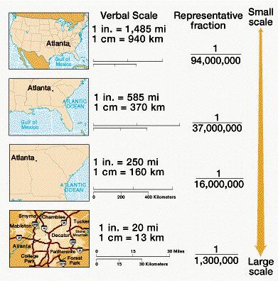
3 Scale Small-scale map 1:250, 000 shows less detail of a large area! Large-scale map 1:50,000 shows more detail of a small area!
4

5 Latitude and Longitude
6 MAP PROJECTIONS Ø What is a Map Projection? Ø Properties of Map Projections Ø Types of Map Projections
 ARE TRANSFORMED FROM A 3 - DIMENSIONAL SPHERE TO A 2 -")
7 What is a Map Projection? THE ONLY TRUE REPRESENTATION OF EARTH, FREE OF DISTORTION IS A GLOBE. MAPS ARE FLAT PROCESS BY WHICH GEOGRAPHIC LOCATIONS (LAT & LONG) ARE TRANSFORMED FROM A 3 - DIMENSIONAL SPHERE TO A 2 - DIMENSIONAL FLAT MAP IS CALLED A PROJECTION


8 Distortions EVERY MAP PROJECTION DISTORTS AT LEAST THREE, AND SOMETIMES ALL FOUR, OF THE FOLLOWING PROPERTIES: ü SHAPE ü AREA ü DISTANCE ü DIRECTION

9 Properties of Projections The Cartographer decides on which projection to use depending on which properties of the earth are to be kept in the flat map. The following slides will give you a more detailed idea of these properties which will help you select the best map for your particular purpose.
10 Properties of Map Projections 1. CONFORMAL: A CONFORMAL PROJECTION MAINTAINS SHAPE IN SMALL LOCALIZED AREAS 2. EQUAL AREA: THESE PROJECTIONS SHOW THE AREAS OF ALL REGIONS ON THE MAP IN THE SAME PROPORTION TO THEIR TRUE AREAS ON THE GLOBE. 3. EQUIDISTANT: NO MAP CAN SHOW DISTANT CORRECTLY BETWEEN ALL POINTS ON A MAP, BUT ONLY FROM ONE, OR AT MOST TWO, POINTS TO ANY OTHER POINT. THIS PROJECTION MAINTAINS DISTANCE. 4. AZIMUTHAL: THIS PROJECTION CORRECTLY SHOWS DIRECTIONS (AZIMUTHS) FROM A SINGLE POINT TO ALL OTHER POINTS ON A MAP.
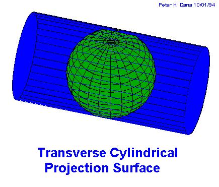
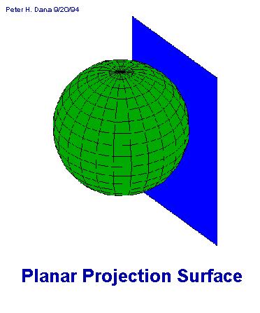
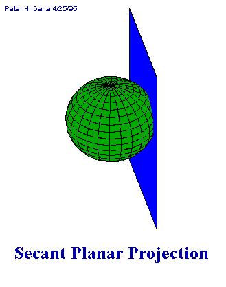
11 Types of Map Projections Map projections are related to either a cylinder, cone or plane. Imagine a transparent globe with a light in the middle. You can project the globe onto a flat sheet of paper just as a picture is projected on a screen. In this case, because the earth is round, the paper can be rolled into a cylinder, a cone, or a plane. The projection is made, and the paper is unrolled to reveal your map! Even where you place the light source to make the projection becomes an issue. Does the light source go in the middle of the globe (Gnomonic), touching the globe (Stereographic) or off the globe altogether (Orthographic)? So, we have three basic types of map projections: 1. Cylindrical 2. Conical 3. Planar
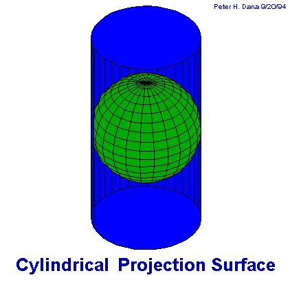
12 Cylindrical Projections

13 Cylindrical Projections-The Map

14 Cylindrical Projections-The Map

15 Cylindrical Projections-The Map
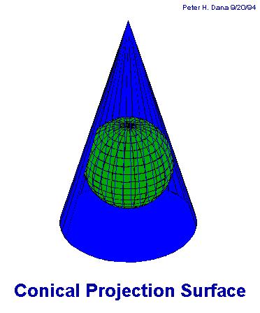
16 Conical Projections

17 Conical Projections The Map Notice: this projection preserves the shape or conformal property

18 Conical Projections The Map Notice: this projection preserves the distance property
19 Azimuthal Projections

20 Azimuthal Projections The Map

21 Azimuthal Projections The Map

22 Azimuthal Projections The Map


23 Mercator Projection " Developed in the 16th century " Great for navigation because all lines of longitude and latitude are the same

24 Mercator Distortions: GREENLAND " Which is bigger Australia or Greenland? AUSTRALIA On the map Greenland. In reality, Australia is three times larger! " As you move away from the equator the map becomes more stretched

25 Peter s Projection " Created in the 1970s as an alternative to Mercator " Creator stated it was more neutral and less racist than Mercator

26 Peters Distortion " Which is bigger Australia or Greenland? On this map Australia is bigger, nation sizes are closer to reality " However the shape of nations is distorted " This projection is often referred to as hanging laundry GREENLAND AUSTRALIA

27 Robinson Projection " Created in 1963 " Purposely distorted to create a more pleasant appearance

28 Robinson Distortion: " The most popular and commonly used map projection " The major areas of distortions are at the poles " Still has a Eurocentric view of the world
29 Summary A Cartographer decides which map projection to use for his/her purposes. You chose your projection based on the properties you want to preserve: equidistant distance preserved conformal shape preserved equal area area preserved azimuthal directions are preserved

30 Summary You then decide on which type of projection you want. This depends on which area of the earth you want to display and how you want to display it: Cylindrical eg. Mercator Conical eg. Lambert Planar eg. Azimuthal Each type of projection is associated with many different projections that preserve different properties. They each get their own name. For example, there is a Lambert Conformal Conic AND a Lambert Equidistant Conic
: Online. Internet. Available at http://www.colorado.")
31 References Most of the diagrams in this presentation were borrowed from the following website. Dana, Peter H., Map Projection Overview, University of Colorado Boulder. (October, 2000): Online. Internet. Available at notes/mapproj/mapproj.html
32 The End!
Georeferencing. datum. projection. scale. The next few lectures will introduce you to these elements. on the Earth, you ll need to understand how
 Georeferencing GOAL: To assign a location to all the features represented in our geographic information data In order to do so, we need to make use of the following elements: ellipsoid/geoid To determine
Referencing map features: Coordinate systems and map projections
 Referencing map features: Coordinate systems and map projections Coordinate systems and map projections if we want to integrate geographic data from many different sources, we need to use a consistent
Map projections. Rüdiger Gens
 Rüdiger Gens Coordinate systems Geographic coordinates f a: semi-major axis b: semi-minor axis Geographic latitude b Geodetic latitude a f: flattening = (a-b)/a Expresses as a fraction 1/f = about 300
What is a Map Projection?
 What is a Map Projection? It is how we represent a three dimensional Earth on a flat piece of paper However The process of transferring information from the Earth to a map causes every projection to distort
Map Projections. is about presenting the round Earth on a flat surface.map Projections: Vermeer s Cartographer
 Map Projections is about presenting the round Earth on a flat surface.map Projections: Vermeer s Cartographer What is a map projection? A projection is a way to make a flat representation of the Earth
Map projections. Rüdiger Gens
 Rüdiger Gens 2 Outline! Relevant terms! Why map projections?! Map projection categories " Projection surfaces " Features preserved from distortions! Map projection examples! Right choice Relevant terms!
How can we project a 3D globe onto a 2D display? - Ellipsoids and Datums deal with earth non-sphericity
 Map projections How can we project a 3D globe onto a 2D display? - Ellipsoids and Datums deal with earth non-sphericity http://www.mapovasbirka.cz/english/index_eng.html The world could be mapped like
Introduction to Cartography GEOG 2016 E. Lecture-2 Geodesy and Projections
 Introduction to Cartography GEOG 2016 E Lecture-2 Geodesy and Projections What is Geodesy? The science of geodesy determines: Earth s shape and Interrelation of different points on earth s surface The
Map Projections. Chapter 4 MAP PROJECTION
 Map Projections Chapter 4 Map Projections What is map projection? Why are map projections drawn? What are the different types of projections? Which projection is most suitably used for which area? In this
Map Projections. What does the world look like? AITOFF AZIMUTHAL EQUIDISTANT BEHRMANN EQUAL AREA CYLINDRICAL
 Map Projections What does the world look like? AITOFF AZIMUTHAL EQUIDISTANT BEHRMANN EQUAL AREA CYLINDRICAL 1 CYLINDRICAL EQUAL AREA BONNE CRASTER PARABOLIC 2 ECKERT I ECKERT III ECKERT V There are many
Projections Part I - Categories and Properties James R. Clynch February 2006
 I. Introduction and References Projections Part I - Categories and Properties James R. Clynch February 2006 The world is, approximately, a sphere. Maps are flat. Making maps requires some method of putting
Outline. Shape of the Earth. Geographic Coordinates (φ, λ, z) Ellipsoid or Spheroid Rotate an ellipse around an axis. Ellipse.
 Ellipsoid or Spheroid Rotate an ellipse around an axis. Ellipse.") Map Projections Outline Geodesy and map projections Prof. D. Nagesh Kumar Department of Civil Engineering Indian Institute of Science Bangalore 560 012, India http://www.civil.iisc.ernet.in/~nagesh Shape
Map Projections Outline Geodesy and map projections Prof. D. Nagesh Kumar Department of Civil Engineering Indian Institute of Science Bangalore 560 012, India http://www.civil.iisc.ernet.in/~nagesh Shape
GIST 3300 / Geographic Information Systems. Last Time. Today
 GIST 3300 / 5300 Last Time Ellipsoids and Datums Today Map Projections Map Projections Today we will build on the concepts of Geographic Coordinate Systems, Ellipsoids and Datums and add the concepts of
Map Projections (Part 1)
") 1 Earth is a round, maps are not. Four projection families. Equivalent (Equal Area) projections Preserves relative areas Commonly used for thematic maps Ex: Albers Conformal projections Preserve angles,
1 Earth is a round, maps are not. Four projection families. Equivalent (Equal Area) projections Preserves relative areas Commonly used for thematic maps Ex: Albers Conformal projections Preserve angles,
Notes on Projections Part II - Common Projections James R. Clynch February 2006
 Notes on Projections Part II - Common Projections James R. Clynch February 2006 I. Common Projections There are several areas where maps are commonly used and a few projections dominate these fields. An
Maps: Geography s Basic Tools
 Maps: Geography s Basic Tools What is a map? - A map is a representation of the earth s features drawn on a flat surface. - Maps use points, lines, colours, and symbols to represent the features of an
Working with georeferenced data. What is georeferencing? Coordinate Systems. Geographic and Projected Coordinate System
 GIS501 Fundamentals of Geographical Information Systems (GIS) Coordinate Systems Working with georeferenced data What is georeferencing? Geographically referenced data which is, in some way, referenced
Map Projections. Displaying the earth on 2 dimensional maps
 Map Projections Displaying the earth on 2 dimensional maps Map projections Define the spatial relationship between locations on earth and their relative locations on a flat map Are mathematical expressions
Map Projections 2/4/2013. Map Projections. Rhumb Line (Loxodrome) Great Circle. The GLOBE. Line of constant bearing (e.g., 292.
 Great Circle. The GLOBE. Line of constant bearing (e.g., 292.") The GLOBE ADVANTAGES Directions True Distances True Shapes True Area True DISADVANTAGES Very small scale with little detail. Costly to reproduce and update. Difficult to carry around. Bulky to store. FACTS
The GLOBE ADVANTAGES Directions True Distances True Shapes True Area True DISADVANTAGES Very small scale with little detail. Costly to reproduce and update. Difficult to carry around. Bulky to store. FACTS
WHERE ARE YOU? Maps & Geospatial Concepts Fall 2012
 WHERE ARE YOU? Maps & Geospatial Concepts Fall 2012 Where are you? Relative location I m at school Absolute Location 45 26 18.07 122 43 50.78 Datums Datums A reference surface of the Earth Used as the
Plane coordinates ~~~~~~~~~~
 Coordinate Systems & Map Projections Geographic coordinates A Basic Introduction to Coordinate Systems & Map Projections Latitude & longitude Angles Parallels & meridians Lines Plane coordinates ~~~~~~~~~~
Geographic coordinate systems
 1 Geographic coordinate systems In this chapter you ll learn about longitude and latitude. You ll also learn about the parts that comprise a geographic coordinate system including Spheres and spheroids
WHERE ARE YOU? Maps & Geospatial Concepts Fall 2015
 WHERE ARE YOU? Maps & Geospatial Concepts Fall 2015 Where are you? Relative location I m at school Absolute Location 45 26 18.07 122 43 50.78 Where is Boston? Introducing Geodesy, Ellipsoids & Geoids Geodesy
Map Projections & Coordinate Systems
 Map Projections & Coordinate Systems 9/7/2017 1 Why? Laying the Earth Flat Need convenient means of measuring and comparing distances, directions, areas, shapes. Traditional surveying instruments measure
Importance of Understanding Coordinate Systems and Map Projections.
 Importance of Understanding Coordinate Systems and Map Projections. 1 It is extremely important that you gain an understanding of coordinate systems and map projections. GIS works with spatial data, and,
Georeferencing, Map Projections, Cartographic Concepts. -Coordinate Systems -Datum
 Georeferencing, Map Projections, Cartographic Concepts -Map Projections -Coordinate Systems -Datum Map projection is "the process of systematically transforming positions on the Earth's spherical surface
Introduction to Geoinformatics I
 Introduction to Geoinformatics I MAP CONCEPT Definition: 1) A map is a visual representation of an area a symbolic depiction highlighting relationships between elements of that space such as objects, regions,
Map Projections. Chapter 3. Emmanuel Stefanakis
 Stefanakis, E., 2014. Geographic Databases and Information Systems. CreateSpace Independent Publ. [In English], pp.386. Get a copy from Amazon Chapter 3 Map Projections Emmanuel Stefanakis http://www2.unb.ca/~estef/
Introduction to Geographic Information Science. Updates/News. Last Lecture. Geography 4103 / Map Projections and Coordinate Systems
 Geography 4103 / 5103 Introduction to Geographic Information Science Map Projections and Coordinate Systems Updates/News Thursday s lecture Reading discussion 1 find the readings online open questions,
Chapter 3 Models of the Earth. 3.1 Finding Locations on the Earth. 3.1 Objectives
 Chapter 3 Models of the Earth 3.1 Finding Locations on the Earth 3.1 Objectives Explain latitude and longitude. How can latitude and longitude be used to find locations on Earth? How can a magnetic compass
Spatial Data, 16 th Century Dutchmen, GPS and GIS. Martin Charlton, National Centre for Geocomputation National University of Ireland Maynooth
 Spatial Data, 16 th Century Dutchmen, GPS and GIS Martin Charlton, National Centre for Geocomputation National University of Ireland Maynooth Maps as truth Maps are cultural artifacts, comparable in history
ch02.pdf chap2.pdf chap02.pdf
 Introduction to Geographic Information Systems 8th Edition Karl Solutions Manual Full Download: http://testbanklive.com/download/introduction-to-geographic-information-systems-8th-edition-karl-solutions-manu
Dirty REMOTE SENSING : Lecture 8 A mapping interlude..
 Dirty REMOTE SENSING : Lecture 8 A mapping interlude.. Stuart Green Teagasc Spatial Analysis Group Stuart.green@teagasc.ie Web for the Week: http://electronics.howstuffworks.com/gps.htm http://www.cstars.ucdavis.edu/classes/ers186-w03/lecture17/lecture17.ppt
Applied Cartography and Introduction to GIS GEOG 2017 EL. Lecture-1 Chapters 1 and 2
 Applied Cartography and Introduction to GIS GEOG 2017 EL Lecture-1 Chapters 1 and 2 What is GIS? A Geographic Information System (GIS) is a computer system for capturing, storing, querying, analyzing and
Shape e o f f the e Earth
 1 Coordinate Systems & Projections Coordinate Systems Two map layers are not going to register spatially unless they are based on the same coordinate system. 2 Contents Shape of the earth Datum Projections
Modern Navigation. Thomas Herring
 12.215 Modern Navigation Thomas Herring Today s class Map Projections: Why projections are needed Types of map projections Classification by type of projection Classification by characteristics of projection
An interactive tool for teaching map projections
 An interactive tool for teaching map projections Map projections are one of the fundamental concepts of geographic information science and cartography. An understanding of the different variants and properties
Georeferencing. Place names Postal addresses Postal codes Coordinate systems (lat/long, UTM, etc.)
") Georeferencing Georeferencing Used to describe the act of assigning locations to data or information Certain requirements include that they are: unique, have shared meaning, and are persistent through
Georeferencing Georeferencing Used to describe the act of assigning locations to data or information Certain requirements include that they are: unique, have shared meaning, and are persistent through
NR402 GIS Applications in Natural Resources Lesson 4 Map Projections
 NR402 GIS Applications in Natural Resources Lesson 4 Map Projections From http://www.or.blm.gov/gis/ 1 Geographic coordinates Coordinates are expressed as Latitude and Longitude in Degrees, Minutes, Seconds
Welcome to Lesson 4. It is important for a GIS analyst to have a thorough understanding of map projections and coordinate systems.
 Welcome to Lesson 4. It is important for a GIS analyst to have a thorough understanding of map projections and coordinate systems. A GIS without coordinates would simply be a database like Microsoft Excel
PROJECTIONS AND COORDINATES EXPLORED THROUGH GOOGLE EARTH EXERCISE (SOLUTION SHEET)
") PROJECTIONS AND COORDINATES EXPLORED THROUGH GOOGLE EARTH EXERCISE (SOLUTION SHEET) Name: Date: Period: Note: Correct answers on some problems are indicated with a yellow highlight. PROJECTIONS 1. Here
PROJECTIONS AND COORDINATES EXPLORED THROUGH GOOGLE EARTH EXERCISE (SOLUTION SHEET) Name: Date: Period: Note: Correct answers on some problems are indicated with a yellow highlight. PROJECTIONS 1. Here
Projections and Coordinate Systems
 Projections and Coordinate Systems Overview Projections Examples of different projections Coordinate systems Datums Projections Overview Projections and Coordinate Systems GIS must accurately represent
Map Projections. Which ones best suit your needs?
 1 z 21 2010-02-20 18:38 Map Projections The Globe Mercator Transverse Mercator Oblique Mercator Space Oblique Mercator Miller Cylindrical Robinson Sinusoidal Equal Area Orthographic Stereographic Gnomonic
The Elements of GIS. Organizing Data and Information. The GIS Database. MAP and ATRIBUTE INFORMATION
 GIS s Roots in Cartography Getting Started With GIS Chapter 2 Dursun Z. Seker MAP and ATRIBUTE INFORMATION Data (numbers and text) store as files refer to them collectively as a database gather inform.
Map Projections & Coordinate Systems 9/10/2013. Why? M. Helper GEO327G/386G, UT Austin 2. M. Helper GEO327G/386G, UT Austin 4
 Map Projections & Coordinates Laing the earth flat Wh? Need convenient means of measuring and comparing distances, directions, areas, shapes. Traditional surveing instruments measure in meters or feet,
Lesson 5: Map Scale and Projections
 Organizing Data and Information Lesson 5: Map Scale and Projections Map Scales Projections Information can be organized as lists, numbers, tables, text, pictures, maps, or indexes. Clusters of information
1. Geospatial technology rarely links geospatial data to nonspatial data. a. True *b. False
 Chapter 2 Where in the Geospatial World Are You? 1. Geospatial technology rarely links geospatial data to nonspatial data. 2. For geospatial technology to work, every location on Earth must be: a. inhabited
Map Projections & Coordinate Systems 9/7/2017
 Map Projections & Coordinate Sstems Laing the Earth Flat Wh? Need convenient means of measuring and comparing distances, directions, areas, shapes. Traditional surveing instruments measure in meters or
Fri. Jan. 26, Demonstration of QGIS with GPS tracks. Types of data, simple vector (shapefile) formats
 formats") Fri. Jan. 26, 2018 Demonstration of QGIS with GPS tracks Types of data, simple vector (shapefile) formats Map projections, Coordinate Reference Systems Demonstration of QGIS with geologic map 1 Raster
Fri. Jan. 26, 2018 Demonstration of QGIS with GPS tracks Types of data, simple vector (shapefile) formats Map projections, Coordinate Reference Systems Demonstration of QGIS with geologic map 1 Raster
The Sphere of the Earth Activities
 The Sphere of the Earth Activities December 20, 2012 Daniel Ramos MMACA (Museu de Matemàtiques de Catalunya) These activities are designed to be done with the materials, posters and software of the exhibit
Introduction to Cartography Part II
 Introduction to Cartography Part II Introduction to Cartography Map Projections GIS GPS Remote Sensing Misrepresentation with Maps Map Projections Mathematical method for systematically transforming a
GMT TECHNICAL REFERENCE & COOKBOOK Azimuthal Projections Lambert Azimuthal Equal-Area ( Ja or JA)
") GMT TECHNICAL REFERENCE & COOKBOOK 5 7 5.3 Azimuthal Projections 5.3.1 Lambert Azimuthal Equal-Area ( Ja or JA) This projection was developed by Lambert in 1772 and is typically used for mapping large
GMT TECHNICAL REFERENCE & COOKBOOK 5 7 5.3 Azimuthal Projections 5.3.1 Lambert Azimuthal Equal-Area ( Ja or JA) This projection was developed by Lambert in 1772 and is typically used for mapping large
The Wildlife Society Meet and Greet. Come learn about what the UNBC Student Chapter of TWS is all about!
 Georeferencing I GEOG 300, Lecture 4 Dr. Anthony Jjumba 1 The Wildlife Society Meet and Greet Quiz Come learn about what the UNBC Student Chapter of TWS is all about! 5:30 7:30 PM, Wednesday September
A map is a small-scale flat-surface representation of some portion of the earth s surface.
 MAPS AND CHARTS A map is a small-scale flat-surface representation of some portion of the earth s surface. A representation that is designed for plotting navigational information is called a chart. Often
History of Cartography,
 Maps History of Cartography, the art and science of making maps ~2300 BC ~600 BC Early oldest known maps: Babylonian clay tablets. Greek and Roman Ptolemy s (about AD 85-165) "world map" depicted the Old
Coordinate Systems. Location on earth is defined by coordinates
 Coordinate Systems We think of the earth as a sphere It is actually a spheroid (ellipsoid), slightly larger in radius at the equator than at the poles Shape of the Earth Location on earth is defined by
GLOBES VERSUS FLAT MAPS
 3 Map projections A map projection is a geometrical transformation of the earth's spherical or ellipsoidal surface onto a flat map surface. Much has been written about map projections, yet people still
Lecture 4. Coordinate Systems & Projections
 Lecture 4 Coordinate Systems & Projections Outline Geodesy Geoids Ellipsoids Geographic Coordinate Systems Magnetic North vs. True North Datums Projections Applying Coordinate Systems and Projections Why
A. Spatial Sense (Working with Maps, Globes, and Other Geographic Tools)
") A. Spatial Sense (Working with Maps, Globes, and Other Geographic Tools) Measuring Distance Using Map Scale All maps are drawn to scale; that is, they are smaller than the things they represent. Scale
A. Spatial Sense (Working with Maps, Globes, and Other Geographic Tools) Measuring Distance Using Map Scale All maps are drawn to scale; that is, they are smaller than the things they represent. Scale
EnvSci360 Computer and Analytical Cartography
 EnvSci360 Computer and Analytical Cartography Lecture 3 Geodesy Map Projections, Datums, and Coordinate Systems 1 Geodesy The science of measuring and representing the shape and size of the earth, and
Geo Referencing & Map projections CGI-GIRS 0910
 Geo Referencing & Map projections CGI-GIRS 0910 Where are you? 31UFT8361 174,7 441,2 51 58' NB 5 40' OL 2/60 Who are they? 3/60 Do geo data describe Earth s phenomena perfectly? Georeference systems ellipsoid
Cartographers would certainly find
 WHAT S A by Cynthia Levinson Cartographers would certainly find their job much easier if the earth were like a paper towel roll or an ice cream cone and not like a sphere. Why? Because you can wrap a sheet
This week s topics. Week 6. FE 257. GIS and Forest Engineering Applications. Week 6
 FE 257. GIS and Forest Engineering Applications Week 6 Week 6 Last week Chapter 8 Combining and splitting landscape features and merging GIS databases Chapter 11 Overlay processes Questions? Next week
2. GETTING STARTED WITH GIS
 2. GETTING STARTED WITH GIS What are geographic information systems and what are they used for? ArcGIS: ArcMap, ArcCatalog and ArcToolbox Vector data vs. raster data vs. attribute tables Polygons, polylines,
Map Projections & Coordinate Systems 1/25/2018
 Map Projections & Coordinate Sstems Laing the Earth Flat How? Projections transformation of curved earth to a flat map; sstematic rendering of the lat. & lon. graticule to rectangular coordinate sstem.
Chapter 1: The World of Geography
 Chapter 1: The World of Geography Chapter 1: What is Geography? *It is the study of our earth; our home. OR *Anything that can be mapped! *Geography mixes up the physical and human aspects of our world
ArcGIS for Applied Economists Session 2
 ArcGIS for Applied Economists Session 2 Mark Westcott LMU Munich June 15, 2015 1 / 31 Topics for this session: Geographic Coordinate Systems Projections Projected Coordinate Systems Geocoding 2 / 31 Some
MAP PROJECTION PROPERTIES: CONSIDERATIONS FOR SMALL-SCALE GIS APPLICATIONS. Eric M. Delmelle
 MAP PROJECTION PROPERTIES: CONSIDERATIONS FOR SMALL-SCALE GIS APPLICATIONS by Eric M. Delmelle A project submitted to the Faculty of the Graduate School of State University of New York at Buffalo in partial
Introduction to Geography
 Introduction to Geography ropic of Cancer 3½ N Arctic Circle 90 N Prime Meridian 0 Arctic Ocean Mississippi R. Appalachian Mts. Europe Rocky Mountains N. America Atlantic Gulf of Ocean Mexico Caribbean
Chapter 02 Maps. Multiple Choice Questions
 Chapter 02 Maps Multiple Choice Questions 1. Every projection has some degree of distortion because A. a curved surface cannot be represented on a flat surface without distortion. B. parallels and meridians
Choosing a Suitable Projection for Navigation in the Arctic
 Choosing a Suitable Projection for Navigation in the Arctic Dr. Andriani Skopeliti, Prof. Lysandros Tsoulos Cartography Laboratory, School of Rural and Surveying Engineering, National Technical University
2 Mapping Earth Reading Essentials. 2. Contrast What is the difference between a map view and a profile view?
 Mapping Earth Maps What do you think? Read the three statements below and decide whether you agree or disagree with them. Place an A in the Before column if you agree with the statement or a D if you disagree.
Geo Referencing & Map projections CGI-GIRS 0910
 Geo Referencing & Map projections CGI-GIRS 0910 Where are you? 31UFT8361 174,7 441,2 51 58' NB 5 40' OL 2/60 Who are they? 3/60 Do geo data describe Earth s phenomena perfectly? Georeference systems ellipsoid
AP Human Geography Chapter 1: Thinking Geographically Key Issue 1: How do Geographers describe where things are?
 AP Human Geography Chapter 1: Thinking Geographically Key Issue 1: How do Geographers describe where things are? Studying Human Geography Physical Geography Physical geography deals with Earth s natural
Maps and Map Projections
 38 The Global Positioning System The Global Positioning System (GPS) is a modern technology for determining a location on Earth. This high-tech system was originally created for military applications but
Smallworld Core Spatial Technology 4 Presenting the globe in a flat space managing projections and coordinate systems
 Smallworld Core Spatial Technology 4 Presenting the globe in a flat space managing projections and coordinate systems 2004 General Electric Company. All Rights Reserved GER-4229 (10/04) Abstract Many of
Navigation. Longitude and Latitude Foundations of Navigation. MTPs:
 Navigation 3.01 Foundations of Navigation References: FTGU pages 177-178, 184-190 Transport Canada Study and Reference Guide Glider Pilot Canada Flight Training Manual Pilot Navigation http://en.wikipedia.org/wiki/transverse_mercator_projection#spherical_transverse_mercator
MR. GOFF S WORLD HISTORY UNIT ONE: GEOGRAPHY 5 THEMES OF GEOGRAPHY
 MR. GOFF S WORLD HISTORY UNIT ONE: GEOGRAPHY 5 THEMES OF GEOGRAPHY BYOD BRING YOUR OWN DEVICE IN SMALL GROUPS (3-4), USE YOUR ELECTRONIC DEVICE(S) AND DEFINE THE FOLLOWING VOCAB. WORDS 1. GEOGRAPHY 2.
REFERENCING COORDINATE SYSTEMS MAP PROJECTIONS GEOREFERENCING
 GIS in Ecology SPATIAL REFERENCING COORDINATE SYSTEMS MAP PROJECTIONS GEOREFERENCING : :1 Where on earth? Early mapmakers recognized the need for a system that could locate features on the earth's surface.
Name Class Date. For each pair of terms, explain how the meanings of the terms differ.
 Skills Worksheet Chapter Review USING KEY TERMS For each pair of terms, explain how the meanings of the terms differ. 1. true north and magnetic north 2. latitude and longitude 3. equator and prime meridian
Dr. ABOLGHASEM AKBARI Faculty of Civil Engineering & Earth Resources, University Malaysia Pahang (UMP)
") Workshop on : Dr. ABOLGHASEM AKBARI Faculty of Civil Engineering & Earth Resources, University Malaysia Pahang (UMP) 14-15 April 2016 Venue: Tehran, Iran GIS definitions GIS: A simplified view of the real
Workshop on : Dr. ABOLGHASEM AKBARI Faculty of Civil Engineering & Earth Resources, University Malaysia Pahang (UMP) 14-15 April 2016 Venue: Tehran, Iran GIS definitions GIS: A simplified view of the real
Lecture 10-14: Map Projections and Coordinate System
 URP 1281 Surveying and Cartography Lecture 10-14: Map Projections and Coordinate System December 27, 2015 Course Teacher: Md. Esraz-Ul-Zannat Assistant Professor Department of Urban and Regional Planning
Geographers Tools: Maps and their Parts
 MP MKIG Geographers Tools: Maps and their Parts Prof. nthony Grande Hunter ollege Geography Lecture design, content and presentation FG 0616. Individual images and illustrations may be subject to prior
THE EARTH AND ITS REPRESENTATION
 UNIT 7 THE EARTH AND ITS REPRESENTATION TABLE OF CONTENTS 1 THE EARTH AND THE SOLAR SYSTEM... 2 2 THE EARTH S MOVEMENTS... 2 2.1 Rotation.... 2 2.2 The revolution of the Earth: seasons of the year....
What is a map? A simple representation of the real world Two types of maps
 Mapping with GIS What is a map? A simple representation of the real world Two types of maps Reference maps showing reference features such as roads, locations, political boundaries, cities etc. Thematic
EXTRA CREDIT. 6 Geographers Tools. Maps and their Parts MAP MAKING QUANDRY MAP MAKING
 EXTRA CREDIT Extra Credit Atlas Exercise for Exam I is available on the course home page. Submit answers to me using the blue Scantron sheet by Feb. 19, 2019. Once you have completed the exercise, transfer
EXTRA CREDIT. 6 Geographers Tools. Maps and their Parts MAP MAKING QUANDRY MAP MAKING 2/15/19 MAP PROJECTIONS MAP PROJECTIONS
 EXTRA CREDIT Extra Credit Atlas Exercise for Exam I is available on the course home page. Submit answers to me using the blue Scantron sheet by Feb. 19, 2019. Once you have completed the exercise, transfer
What is a map? A Map is a two or three-dimensional model or representation of the Earth s surface. 2-Dimensional map
 What is a map? A Map is a two or three-dimensional model or representation of the Earth s surface. 2-Dimensional map What is a Map Projection? Planar Projection Projection A Projection is a mathematical
2. What does the map scale tell the map reader? a ratio between the actual distance on the ground and the length given to that distance on a map
 AP Human Geography - Damon Name Unit 1 - Intro to Human Geography Hour Map and Globe Skills Review Note: All links in this packet are found on our Wikispace under Map and Globe Skills Review First, read
Intro to GIS Fall 2010 Georeferencing & Map Projections
 Intro to GIS Fall 2010 Georeferencing & Map Projections SHAPE OF THE EARTH Earth's Shape Geoid: shape of earth minus topographic features (irregular due to local variations in gravity) Ellipsoid: elongated
1/28/16. EGM101 Skills Toolbox. Oblate spheroid. The shape of the earth Co-ordinate systems Map projections. Geoid
 EGM101 Skills Toolbox Oblate spheroid The shape of the earth Co-ordinate systems Map projections The geoid is the shape that the surface of the oceans would take under the influence of Earth's gravitation
Understanding Projections for GIS
 Presented by John Schaeffer Juniper GIS Services, Inc. This PowerPoint is available at JuniperGIS.com Presentation Objectives To understand basic concepts on projections and coordinate systems for the
Introduction to Geography
 Introduction to Geography What is geography? Geography comes from the Greek word Geographia. Geo means earth and graphia means to describe or chart. Geographers study the earth in relation to space and
Exercise 6: Coordinate Systems
 Exercise 6: Coordinate Systems This exercise will teach you the fundamentals of Coordinate Systems within QGIS. In this exercise you will learn: How to determine the coordinate system of a layer How the
First Exam: New Date. 6 Geographers Tools Maps and their Parts 9/14/2017 MAP MAKING MAP MAKING MAP PROJECTIONS MAP PROJECTIONS
 6 Geographers Tools Maps and their Parts Prof. nthony Grande Hunter ollege Geography Lecture design, content and presentation FG 0917. Individual images and illustrations may be subject to prior copyright.
2. Environmental issues in the relationship of humankind to the environment
 Course Goals to Understand 1. Processes operating on the earth s surface Atmosphere Lithosphere Hydrosphere Biosphere 2. Environmental issues in the relationship of humankind to the environment 3. Science
FlexiCadastre User Conference 2013 GIS Data Verification & Challenges
 FlexiCadastre User Conference 2013 GIS Data Verification & Challenges May 7, 2013 Amanda Blackmore GIS Specialist OVERVIEW GIS Definitions & Terminology Spatial Data Common Issues or Concerns Data Verification
Data acquisition and integration 1.
 Data acquisition and integration 1. Ferenc Végső Data acquisition and integration 1.: Ferenc Végső Lector: Árpád Barsi This module was created within TÁMOP - 4.1.2-08/1/A-2009-0027 "Tananyagfejlesztéssel
Use your text to define the following term. Use the terms to label the figure below. Define the following term.
 Mapping Our World Section. and Longitude Skim Section of your text. Write three questions that come to mind from reading the headings and the illustration captions.. Responses may include questions about
The due date for submitting this assignment has passed. As per our records you have not submitted this. Both statement 1 and statement 2 are true
 X reviewer3@nptel.iitm.ac.in Courses» Higher Surveying Unit 4 - Week 2 Announcements Course Ask a Question Progress Mentor FAQ Course outline How to access the portal Week 0 Week 1 Week 2 Quiz : Assignment