Exploring ArcIMS Services to Deliver National Weather Service Datasets in Support of Decision-Makers
|
|
|
- Garry King
- 5 years ago
- Views:
Transcription
1 Exploring ArcIMS Services to Deliver National Weather Service Datasets in Support of Decision-Makers 2007 ESRI Federal User Conference Washington, DC January 10, 2007 Jack Settelmaier Digital Techniques Meteorologist National Weather Service, Southern Region Fort Worth, Texas NOAA/National Weather Service Southern Region
2 Collaborators Ken Waters NOAA/NWS Dr. Bernd J. Haupt Earth & Environmental Systems Institute The Pennsylvania State University Maurie Caitlin Kelly Ryan E. Baxter James F. Spayd PS Institutes of Energy & the Environment The Pennsylvania State University
3 Overview National Weather Service (NWS) Structure and tie to Decision-Makers Exploratory NWS Collaborative GIS/IMS Efforts Lessons Learned from PSU Serving NWS NDFD via ArcIMS
4 Department of Commerce (DOC) National Oceanic and Atmospheric Administration (NOAA) Booth 617
5 National Weather Service Structure
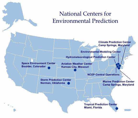
6
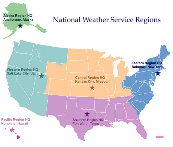
7

8 13 River Forecast Centers NOAA/National Weather Service Southern Region

9 21 Center Weather Service Units NOAA/National Weather Service Southern Region

10 122 NWS Weather Forecast Offices NOAA/National Weather Service Southern Region
 do")


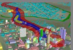
11 What Can the NWS (and others) do with GIS-encoded weather information? Customized Projects/Products/Data Analysis and Display Research, Analysis and Verification Real Time SA Centralize Storage and Standardized Dissemination Flood Impact NOAA/National Weather Service Southern Region
12 Exploratory National Weather Service Collaborative GIS/IMS Efforts

13 NOAA/NWS/EMHURR IMS NOAA/National Weather Service Southern Region Courtesy NCDC
14 NOAA/NOS/NowCOAST IMS Courtesy NCDC

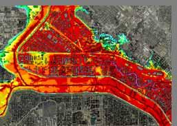
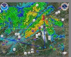
15 New GIS-ready Radar Imagery Available as time loops for Weather Service Radars New GIS Topographic Base Map Provides real time storm, movement, precipitation and now, velocity data!

16 RIDGE (Radar Integrated Display with Geospatial Elements) Collaborative Effort with NCTCOG using technology found in FWD graphical warning project.
17 Georeferenced Radar Images NOAA/National Weather Service Southern Region


18 Old vs New Radar Imagery NOAA/National Weather Service Southern Region
19


 watches/warnings Observed")
20 Severe Weather Prototype Live IMS for Severe Weather Season 2004 (geared towards emergency managers) Expected Nationwide Coverage Radar and Satellite Data Severe Weather (wind, hail, tornado) watches/warnings Observed Severe Weather Reports
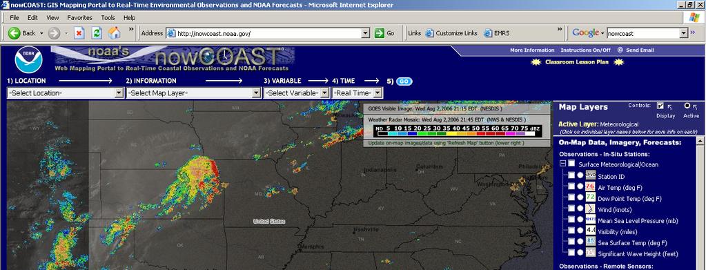

21 NOAA/NOS/NowCOAST IMS Courtesy NCDC
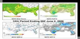
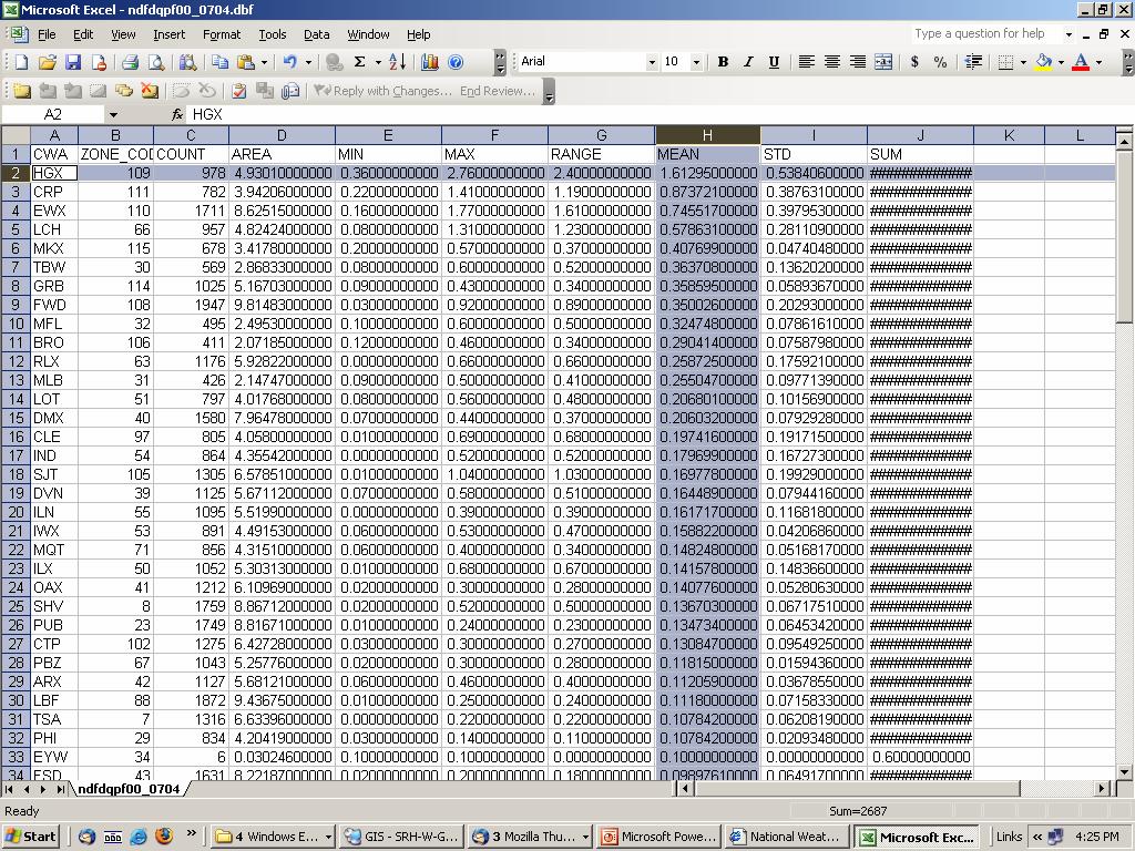
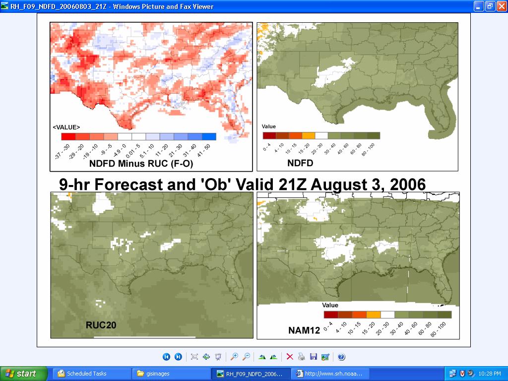
22 Automated Geoprocessing as a Tool to Assess NWS Forecast Quality
23 Benefits Geospatial Depiction of Gridded PoP/QPF Forecasts Tabular Summaries/Statistics of Data Useful for Generating Post-event Recaps Encourages GIS Usage/Exploration Helps Sell Need for Enterprise Solution Across NOAA NOAA/National Weather Service Southern Region
24
25
26
27
28
29
30
31
 NDFD surface")

32 National Digital Forecast Database (NDFD) NDFD surface winds Winds with annotation NOAA/National Weather Service Southern Region
33 What Can t the NWS do with GIS? SERVE IT!
34 What can PSU (and others?) do with weather data in GIS? Segue to PSU portion on Serving NDFD via IMS


35 Developing Internet Map Services with NDFD (NOAA/NWS) Dr. Bernd J. Haupt, Earth & Environmental Systems Institute Maurie Caitlin Kelly, PS Institutes of Energy & the Environment Ryan E. Baxter, PS Institutes of Energy & the Environment James F. Spayd, PS Institutes of Energy & the Environment The Pennsylvania State University In collaboration with Jack Settelmaier (NOAA/NWS), Ken Waters (NOAA/NWS) Presentation for ESRI Federal Users Conference, January 10, 2007 NOAA/National Weather Service Southern Region
36 Who We Are PSIEE & EESI faculty collaborate on several GIS related projects. Project team works with Federal agencies such as the US Geological Survey (USGS); state agencies such as the PA Office of Information Technology, and non profit organizations such as the American Fisheries Society. Currently, project team members manage spatial databases that houses approximately 8 terabytes of data and imagery. Project team members manage the Pennsylvania Geospatial Data Clearinghouse, PASDA, and the geospatial component of the Mid-Atlantic Information Node, MAIN, Initial funding was provided from the Penn State University GIS Council to develop proof of concept for climate and weather data. NOAA/National Weather Service Southern Region
 The NDFD (National Digital Forecast Data) Pilot project was developed by PSIEE and EESI faculty for the following reasons: Most users are unfamiliar with the NDFD data or the types of data formats")
37 Framework for Pilot Project (Why do we need it?) The NDFD (National Digital Forecast Data) Pilot project was developed by PSIEE and EESI faculty for the following reasons: Most users are unfamiliar with the NDFD data or the types of data formats that weather data come in. Most users do not have the processing capabilities or knowledge to acquire and convert and store this data for their own use. We have developed a way for users to incorporate this data into their desktop GIS with a click of a button. This eliminates the need for them to process this data themselves. Emergency managers and response support agencies need this vital information to cope with potential emergency situations. In Pennsylvania, flooding is the primary natural disaster with which emergency managers cope with.
38 Process Steps (6 in total) Overview Identify sources of spatial and temporal data from agencies, organizations, or academic institutions. Develop partnership with data provider. Acquire data from provider or from public access site such as an FTP site (Automate this process where possible). QA/QC data for completeness; convert to GIS format; create metadata; load into ArcSDE (spatial data engine). Create ArcIMS Image and Feature Services which are updated when data is updated in database. (new AXL files with new datasets). Users can bring Image and Feature services directly into their desktop GIS software.
39 Process Steps (step 1) Identify sources of spatial and temporal data from agencies, organizations, or academic institutions. Develop partnership with data provider. Acquire data from provider or from public access site such as an FTP site (Automate this process where possible). QA/QC data for completeness; convert to GIS format; create metadata; load into ArcSDE (spatial data engine). Create ArcIMS Image and Feature Services which are updated when data is updated in database. (new AXL files with new datasets). Users can bring Image and Feature services directly into their desktop GIS software.
40 Process Steps (step 2) Identify sources of spatial and temporal data from agencies, organizations, or academic institutions. Develop partnership with data provider. Acquire data from provider or from public access site such as an FTP site (Automate this process where possible). QA/QC data for completeness; convert to GIS format; create metadata; load into ArcSDE (spatial data engine). Create ArcIMS Image and Feature Services which are updated when data is updated in database. (new AXL files with new datasets). Users can bring Image and Feature services directly into their desktop GIS software.
41 Process Steps (step 3) Identify sources of spatial and temporal data from agencies, organizations, or academic institutions. Develop partnership with data provider. Acquire data from provider or from public access site such as an FTP site (Automate this process where possible). QA/QC data for completeness; convert to GIS format; create metadata; load into ArcSDE (spatial data engine). Create ArcIMS Image and Feature Services which are updated when data is updated in database. (new AXL files with new datasets). Users can bring Image and Feature services directly into their desktop GIS software.
42 Process Steps (step 4) Identify sources of spatial and temporal data from agencies, organizations, or academic institutions. Develop partnership with data provider. Acquire data from provider or from public access site such as an FTP site (Automate this process where possible). QA/QC data for completeness; convert to GIS format; create metadata; load into ArcSDE (spatial data engine). Create ArcIMS Image and Feature Services which are updated when data is updated in database. (new AXL files with new datasets). Users can bring Image and Feature services directly into their desktop GIS software.
43 Process Steps (step 5) Identify sources of spatial and temporal data from agencies, organizations, or academic institutions. Develop partnership with data provider. Acquire data from provider or from public access site such as an FTP site (Automate this process where possible). QA/QC data for completeness; convert to GIS format; create metadata; load into ArcSDE (spatial data engine). Create ArcIMS Image and Feature Services which are updated when data is updated in database. (new AXL files with new datasets). Users can bring Image and Feature services directly into their desktop GIS software.
44 Process Steps (step 6) Identify sources of spatial and temporal data from agencies, organizations, or academic institutions. Develop partnership with data provider. Acquire data from provider or from public access site such as an FTP site (Automate this process where possible). QA/QC data for completeness; convert to GIS format; create metadata; load into ArcSDE (spatial data engine). Create ArcIMS Image and Feature Services which are updated when data is updated in database. (new AXL files with new datasets). Users can bring Image and Feature services directly into their desktop GIS software.
45 Process Steps (step 1a) Identify sources of spatial and temporal data from agencies, organizations, or academic institutions. There are plenty of temporal data available from various sources like: National Oceanic & Atmospheric Administration (NOAA) National Weather Service (NOAA/NWS) today's example US Geological Service (USGS) National Biological Information Infrastructure (NBII) Multi-State Aquatic Resources Information System (MARIS) Universities Government Today, we ll use NOAA/NWS NDFD data as one possible example (NDFD = National Digital Forecast Data; NOAA/National Weather Service Southern Region
 broke the CONUS (Continental Unitied States) into sixteen geographic sub-sectors.")
46 Process Steps (step 1b) Identify sources of spatial and temporal data from agencies, organizations, or academic institutions. The National Digital Forecast Database (NDFD) broke the CONUS (Continental Unitied States) into sixteen geographic sub-sectors. Available variables we are currently serving to the GIS community are: min. & max. temp., 12-hour probability of precipitation, temp., dewpoint, quantitative precipitation forecast (QPF), snow amount, wind direction & speed, significant wave height, sky cover, apparent temp., rel. humidity, wind gust More variables provided by NOAA/NWS and others are hopefully coming soon (depends on interest and time available -- non-funded enterprise) NOAA/National Weather Service Southern Region
47 Process Steps (step 2) Develop partnership with data provider. Developing a relationship with a data provider gives the project a more sustainable base, allows data to be updated more readily, and encourages further cooperation should additional data become available. The following step should be made once a dataset has been identified: The data provider should be contacted to ensure that he/she agrees to the distribution of his/her data by another institution. Appropriate credit should be given in the metadata to the data provider. Disclaimer and use constraints can also be included in the metadata where applicable. NOAA/National Weather Service Southern Region
48 Process Steps (step 3) Acquire data from provider or from public access site such as an FTP site (Automate this process where possible). Some details that the normal user will not get to see and does not have to worry about: Data (e.g., NDFD; ~ 75 MB -- compressed) will be downloaded from the data provider at predetermined time intervals (e.g., every 1-3 hours) via either anonymous FTP or HTTP (Unix, Linux, Cygwin). Parallel downloads immensely speed up data transfer (frequently datasets are split into chunks, which is preferable; note: datasets need to be concatenated to become usable). Avoid sequential data downloads If downloads require a username and password other than an anonymous login, make sure that files are read and write protected, especially on multi-user systems. NOAA/National Weather Service Southern Region
49 Process Steps (step 4) QA/QC data for completeness; convert to GIS format; create metadata; load into ArcSDE (spatial data engine). Check data for completeness Data come in compressed format => Degrib data and convert to ESRI shape files (GRIB2 is the second version of the World Meterological Organization s (WMO) standard for distributing gridded data). Upload ESRI shape files/layers into Spatial Database, e.g., 40 forecast layers for temperature (26 x every 3h = 78h; then 14 x 6h = 84h; forecast for about 1 week) Repeat for all other variables NOAA/National Weather Service Southern Region
 Usually timestamps say, e.g. 3, 6, 9,, 150 hours from now; ours do show real times.")
50 Process Steps (step 5a) Create ArcIMS Image and Feature Services which are updated when data is updated in database. (new AXL files with new datasets). Update time stamp (BONUS; tricky; wait for next slide) Usually timestamps say, e.g. 3, 6, 9,, 150 hours from now; ours do show real times. Problem: A users saves a map and reopens it without remembering the time he saved the map ideally the timestamp should show the forecast time. NOAA/National Weather Service Southern Region

51 Process Steps (step 5b) Create ArcIMS Image and Feature Services which are updated when data is updated in database. (new AXL files with new datasets). Example of metadata degrib ds.temp.bin -I Here is how we update the time stamp 1. Extract timestamp from data archive/metadata 2. Update AXL file with the real time information 3. Stop Feature and Image Service 4. Replace old AXL file with new updated file 5. Restart Feature and Image Service 6. Repeat for all other variables 7. DONE NOAA/National Weather Service Southern Region
52 Process Steps (step 6a) Users can bring Image and Feature services directly into their desktop GIS software. Example of 1 weeks Temperature forecast (Image & Feature Service) The following slides demonstrate how NDFD data can be added into desktop GIS with a click of a button (without having to program thousands of lines of code) NOAA/National Weather Service Southern Region

53 Process Steps (step 6b) Users can bring Image and Feature services directly into their desktop GIS software. GIS weather data with a click of a button! PASDA is funded by the Geospatial Technologies Office of the PA Office for Information Technology

54 Process Steps (step 6c) Users can bring Image and Feature services directly into their desktop GIS software.

55 Process Steps (step 6d) Users can bring Image and Feature services directly into their desktop GIS software. Today s example: NOAA/NWS

56 Process Steps (step 6e) Users can bring Image and Feature services directly into their desktop GIS software.

57 Process Steps (step 6f) Users can bring Image and Feature services directly into their desktop GIS software = 17 variables 3 temporal images 14 NDFD datasets
58 Process Steps (step 6g) Users can bring Image and Feature services directly into their desktop GIS software. Keep slide in mind, we ll return to it.

59 Process Steps (step 6h) Users can bring Image and Feature services directly into their desktop GIS software. Provide appropriate credit

60 Process Steps (step 6i) Users can bring Image and Feature services directly into their desktop GIS software.
61 Process Steps (step 6j) Users can bring Image and Feature services directly into their desktop GIS software. Keep slide in mind, we ll return to it. NOAA/National Weather Service Southern Region


62 Process Steps (step 6k) Users can bring Image and Feature services directly into their desktop GIS software.
63 Process Steps (step 6l) Users can bring Image and Feature services directly into their desktop GIS software. Keep slide in mind, we ll return to it. NOAA/National Weather Service Southern Region

64 Process Steps (step 6m) Users can bring Image and Feature services directly into their desktop GIS software. Three NDFD forecast layers are available for each variable at 3h, 1d, & 2d NOAA/National Weather Service Southern Region

65 Process Steps (step 6n) Users can bring Image and Feature services directly into their desktop GIS software.
 Data are available with a click of a mouse!")
66 Process Steps (step 6o) Users can bring Image and Feature services directly into their desktop GIS software. Example of 1 weeks Temperature forecast (Image & Feature Service) Data are available with a click of a mouse! NOAA/National Weather Service Southern Region
67 Conclusions PSIEE & EESI (PSU) team communicates and collaborates with NOAA/NWS on GIS projects. Together, we, PSIEE, EESI, and NOAA/NWS can grow together for a greater benefit to anyone tapping in We provide continuously updated NOAA/NWS weather data in GIS format to emergency managers and response support agencies as well as the general public. With a click of a mouse users can bring our Image and Feature services directly into their desktop GIS software. NOAA/National Weather Service Southern Region
68 Conclusions II Collaboration works!! Further exploration/resources needed
69 Questions & Comments Dr. Bernd J. Haupt -- (814) Maurie Caitlin Kelly -- (814) Ryan E. Baxter -- (814) In collaboration with Jack Settelmaier -- (817) x 185) Ken Waters (Ken.Waters@noaa.gov -- (808) ) NOAA/National Weather Service Southern Region
Geoprocessing Hydrometeorological Datasets to Assess National Weather Service (NWS) Forecasts
 Forecasts") Geoprocessing Hydrometeorological Datasets to Assess National Weather Service (NWS) Forecasts Jack Settelmaier National Weather Service Southern Region HQ Fort Worth, Texas ABSTRACT The National Weather
Geoprocessing Hydrometeorological Datasets to Assess National Weather Service (NWS) Forecasts Jack Settelmaier National Weather Service Southern Region HQ Fort Worth, Texas ABSTRACT The National Weather
Add NOAA nowcoast Layers to Maps
 WebEOC Maps Add-on Quick Reference Guide Add NOAA nowcoast Layers to Maps Overview With Maps Add-on, you can configure an unlimited number of map layers. These layers allow you to control the data you
NOAA s National Weather Service. National Weather Service
 NOAA s National Weather Service Serving the Nation s Environmental Forecasting Needs Lynn Maximuk Regional Director National Weather Service Central Region Headquarters Kansas City, Missouri America s
GIS at UCAR. The evolution of NCAR s GIS Initiative. Olga Wilhelmi ESIG-NCAR Unidata Workshop 24 June, 2003
 GIS at UCAR The evolution of NCAR s GIS Initiative Olga Wilhelmi ESIG-NCAR Unidata Workshop 24 June, 2003 Why GIS? z z z z More questions about various climatological, meteorological, hydrological and
Contextualizing Impacting Weather and Climate Information via GIS. Jack Settelmaier
 Contextualizing Impacting Weather and Climate Information via GIS Jack Settelmaier NOAA/National Weather Service/SRHQ/Digital Techniques Meteorologist Fort Worth, TX AMS Annual Conference, Jan 2016, New
United States Multi-Hazard Early Warning System
 United States Multi-Hazard Early Warning System Saving Lives Through Partnership Lynn Maximuk National Weather Service Director, Central Region Kansas City, Missouri America s s Weather Enterprise: Protecting
NextGen Update. Cecilia Miner May, 2017
 NextGen Update Cecilia Miner May, 2017 Agenda What s changed? NextGen Background FAA NextGen Weather Architecture NextGen Weather Processor Aviation Weather Display Common Support Services - Weather NWS
NOAA Surface Weather Program
 NOAA Surface Weather Program Maintenance Decision Support System Stakeholder Meeting #9 Jim O Sullivan NOAA Surface Weather Program Manager NWS Office of Climate, Water, and Weather Services September
Real-Time Meteorological Gridded Data: What s New With HEC-RAS
 Real-Time Meteorological Gridded Data: What s New With HEC-RAS Acquisition and Application of Gridded Meteorological Data in Support of the USACE s Real-Time Water Management Mission Fauwaz Hanbali, Tom
Nomination Form. Clearinghouse. New York State Office for Technology. Address: State Capitol-ESP, PO Box
 NASIRE 2001 RECOGNITION AWARDS Recognizing Outstanding Achievement in the Field of Innovative Use of Technology Nomination Form Title of Nomination: Manager/Job Title: Agency: NYS Geographic Information
GIS-T 2010 Building a Successful Geospatial Data Sharing Framework: A Ohio DOT Success Story
 GIS-T 2010 Building a Successful Geospatial Data Sharing Framework: A Ohio DOT Success Story ODOT District 2 GIS John Puente District 1 GIS Coordinator\ Planning Administrator 2 Interoperability 3 District
Rainfall-River Forecasting: Overview of NOAA s Role, Responsibilities, and Services
 Dr. Thomas Graziano Chief Hydrologic Services Division NWS Headquarters Steve Buan Service Coordination Hydrologist NWS North Central River Forecast Center Rainfall-River Forecasting: Overview of NOAA
Guide to Hydrologic Information on the Web
 NOAA s National Weather Service Guide to Hydrologic Information on the Web Colorado River at Lees Ferry Photo: courtesy Tim Helble Your gateway to web resources provided through NOAA s Advanced Hydrologic
David Ruth Meteorological Development Laboratory National Weather Service, NOAA. Measuring Forecast Continuity
 David Ruth Meteorological Development Laboratory National Weather Service, NOAA Measuring Forecast Continuity National Digital Forecast Database (NDFD) Contains a seamless mosaic of NWS digital forecasts
GEOGRAPHIC INFORMATION SYSTEMS Session 8
 GEOGRAPHIC INFORMATION SYSTEMS Session 8 Introduction Geography underpins all activities associated with a census Census geography is essential to plan and manage fieldwork as well as to report results
The NOAA/NWS Warning Decision Training Branch (WDTB): On-line Training Resources for Emergency Managers & Intro to Dual-Polarization Radar
: On-line Training Resources for Emergency Managers & Intro to Dual-Polarization Radar") The NOAA/NWS Warning Decision Training Branch (WDTB): On-line Training Resources for Emergency Managers & Intro to Dual-Polarization Radar Andy Wood CIMMS (University of Oklahoma)/ WDTB (NOAA/NWS) The
The NOAA/NWS Warning Decision Training Branch (WDTB): On-line Training Resources for Emergency Managers & Intro to Dual-Polarization Radar Andy Wood CIMMS (University of Oklahoma)/ WDTB (NOAA/NWS) The
IMPLEMENTING GOVERNMENT-WIDE ENTERPRISE GIS; THE FEDERATED MODEL
 IMPLEMENTING GOVERNMENT-WIDE ENTERPRISE GIS; THE FEDERATED MODEL James E. Mitchell, Ph. D. IT GIS Manager Louisiana Department of Transportation and Development presented at the ESRI International Users
MADIS Airlines for America Briefing
 MADIS Airlines for America Briefing Meteorological Assimilated Data Ingest System (MADIS) FPAW Briefing Steve Pritchett NWS Aircraft Based Observations Program Manager MADIS Defined MADIS is a meteorological
GIS Frameworks in the National Weather Service
 GIS Frameworks in the National Weather Service Eugene Derner Senior Hydrologist NOAA/National Weather Service Missouri Basin River Forecast Center Agenda GIS Brief History In-house GIS Weather GIS Applications
NWS Resources For Public Works
 NWS Resources For Public Works August 28th, 2016 Shawn DeVinny shawn.devinny@noaa.gov Meteorologist National Weather Service Twin Cities/Chanhassen, MN 1 APWA 2016 PWX 8/28/2016 National Weather Service
RHOAPS. Real-time Hydrology Ocean Atmosphere Prediction System. Pronunciation: Ropes Motto: More than just THREDDS
 RHOAPS Real-time Hydrology Ocean Atmosphere Prediction System Pronunciation: Ropes Motto: More than just THREDDS Key Aspects Integrated real-time data systems Atmospheric Hydrologic Coastal oceans Societal
Risk Analysis for Assessment of Vegetation Impact on Outages in Electric Power Systems. T. DOKIC, P.-C. CHEN, M. KEZUNOVIC Texas A&M University USA
 21, rue d Artois, F-75008 PARIS CIGRE US National Committee http : //www.cigre.org 2016 Grid of the Future Symposium Risk Analysis for Assessment of Vegetation Impact on Outages in Electric Power Systems
Spatial Data Infrastructure Concepts and Components. Douglas Nebert U.S. Federal Geographic Data Committee Secretariat
 Spatial Data Infrastructure Concepts and Components Douglas Nebert U.S. Federal Geographic Data Committee Secretariat August 2009 What is a Spatial Data Infrastructure (SDI)? The SDI provides a basis for
NWS Flood Warning Products plus a Look Ahead
 NWS Flood Warning Products plus a Look Ahead September 21 & 22, 2010 DRBC Flood Warning Users Forum Presented by Gary Szatkowski Meteorologist-in-Charge NOAA s National Weather Service Philadelphia/Mt.
Introduction to Weather Analytics & User Guide to ProWxAlerts. August 2017 Prepared for:
 Introduction to Weather Analytics & User Guide to ProWxAlerts August 2017 Prepared for: Weather Analytics is a leading data and analytics company based in Washington, DC and Dover, New Hampshire that offers
CHAPTER 22 GEOGRAPHIC INFORMATION SYSTEMS
 CHAPTER 22 GEOGRAPHIC INFORMATION SYSTEMS PURPOSE: This chapter establishes the administration and use of to improve the quality and accessibility of Department s spatial information and support graphical
GIS in Weather and Society
 GIS in Weather and Society Olga Wilhelmi Institute for the Study of Society and Environment National Center for Atmospheric Research WAS*IS November 8, 2005 Boulder, Colorado Presentation Outline GIS basic
Multi Radar Multi Sensor NextGen Weather Program. Presentation materials sourced from: Ken Howard HydroMet Research Group NSSL Warning R&D Division
 Multi Radar Multi Sensor NextGen Weather Program Presentation materials sourced from: Ken Howard HydroMet Research Group NSSL Warning R&D Division What is Multiple Radar Multi Sensor System () is the world
NOAA S2S Planning. Dave DeWitt Fred Toepfer
 NOAA S2S Planning Dave DeWitt Fred Toepfer 1 Agenda 1. Brief synopsis of The Weather Research and Forecasting Act of 2017 2. Report to Congress a. Timeline b. Process c. Document Outline 3. Some Preliminary
Eastern Shore Weather and Climate. Bill Sammler Warning Coordination Meteorologist National Weather Service Wakefield, VA
 Eastern Shore Weather and Climate Bill Sammler Warning Coordination Meteorologist National Weather Service Wakefield, VA About The NWS The National Weather Service is: A Federal Government Agency Part
baltrad Mass media Overview
 48 Mass media Overview Weather information disseminated through mass media, like press, TV, and Internet is intended for its recipients, not for the media themselves. Therefore the addressees of the media
An Overview of Operations at the West Gulf River Forecast Center Gregory Waller Service Coordination Hydrologist NWS - West Gulf River Forecast Center
 National Weather Service West Gulf River Forecast Center An Overview of Operations at the West Gulf River Forecast Center Gregory Waller Service Coordination Hydrologist NWS - West Gulf River Forecast
FAA-NWS Aviation Weather Weather Policy and Product Transition Panel. Friends and Partners in Aviation Weather October 22, 2014 NOAA NOAA
 FAA-NWS Aviation Weather Weather Policy and Product Transition Panel Friends and Partners in Aviation Weather October 22, 2014 Airplanes have changed. Lockheed Constellation Airbus A380 Aviation weather
Automated Conversion and Processing of Weather Data in Near-Real Time Daniel Konde QSS Group Inc. Rory Moore Raytheon
 Automated Conversion and Processing of Weather Data in Near-Real Time Daniel Konde QSS Group Inc. Rory Moore Raytheon 1.0 Abstract In the spring of 2003 the National Weather Service (NWS) developed an
13.2 USING VIRTUAL GLOBES TO IMPROVE SITUATIONAL AWARENESS IN THE NATIONAL WEATHER SERVICE
 13.2 USING VIRTUAL GLOBES TO IMPROVE SITUATIONAL AWARENESS IN THE NATIONAL WEATHER SERVICE Andy Foster* National Weather Service Springfield, Missouri* Keith Stellman National Weather Service Shreveport,
NR402 GIS Applications in Natural Resources
 NR402 GIS Applications in Natural Resources Lesson 1 Introduction to GIS Eva Strand, University of Idaho Map of the Pacific Northwest from http://www.or.blm.gov/gis/ Welcome to NR402 GIS Applications in
Northrop Grumman Concept Paper
 Northrop Grumman Concept Paper A Comprehensive Geospatial Web-based Solution for NWS Impact-based Decision Support Services Glenn Higgins April 10, 2014 Northrop Grumman Corporation Information Systems
ArcGIS Data Models: Raster Data Models. Jason Willison, Simon Woo, Qian Liu (Team Raster, ESRI Software Products)
") ArcGIS Data Models: Raster Data Models Jason Willison, Simon Woo, Qian Liu (Team Raster, ESRI Software Products) Overview of Session Raster Data Model Context Example Raster Data Models Important Raster
ArcGIS Data Models: Raster Data Models Jason Willison, Simon Woo, Qian Liu (Team Raster, ESRI Software Products) Overview of Session Raster Data Model Context Example Raster Data Models Important Raster
Weather Analysis and Forecasting
 Weather Analysis and Forecasting An Information Statement of the American Meteorological Society (Adopted by AMS Council on 25 March 2015) Bull. Amer. Meteor. Soc., 88 This Information Statement describes
Bloomsburg University Weather Viewer Quick Start Guide. Software Version 1.2 Date 4/7/2014
 Bloomsburg University Weather Viewer Quick Start Guide Software Version 1.2 Date 4/7/2014 Program Background / Objectives: The Bloomsburg Weather Viewer is a weather visualization program that is designed
Preparing For Winter Weather At Home & In The Workplace. Brandon Peloquin, Warning Coordination Meteorologist NWS Wilmington OH
 Preparing For Winter Weather At Home & In The Workplace Brandon Peloquin, Warning Coordination Meteorologist NWS Wilmington OH What We Will Talk About Introduction to the National Weather Service How we
Nurture Nature Center Receives Grant From National Oceanic and Atmospheric Administration To Study Flood Forecast and Warning Tools
 Nurture Nature Center Receives Grant From National Oceanic and Atmospheric Administration To Study Flood Forecast and Warning Tools One of four national awards by National Weather Service to advance weather
Ken R. Waters. NOAA/National Weather Service Honolulu, Hawaii
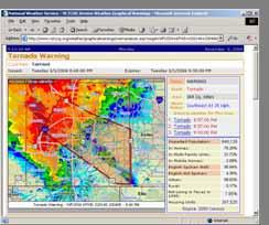
 4.B1 VERIFICATION OF NATIONAL WEATHER SERVICE WARNINGS USING GEOGRAPHIC INFORMATION SYSTEMS Ken R. Waters NOAA/National Weather Service Honolulu, Hawaii 1. INTRODUCTION The NOAA/National Weather Service
WAFS_Word. 2. Menu. 2.1 Untitled Slide
 WAFS_Word 2. Menu 2.1 Untitled Slide Published by Articulate Storyline 1. Introduction 1.1 Introduction Notes: As you will probably be aware, the traditional significant weather forecasts, usually seen
CLIMATE CHANGE ADAPTATION BY MEANS OF PUBLIC PRIVATE PARTNERSHIP TO ESTABLISH EARLY WARNING SYSTEM
 CLIMATE CHANGE ADAPTATION BY MEANS OF PUBLIC PRIVATE PARTNERSHIP TO ESTABLISH EARLY WARNING SYSTEM By: Dr Mamadou Lamine BAH, National Director Direction Nationale de la Meteorologie (DNM), Guinea President,
Homeland Security Geospatial Data Model. Mark Eustis SAIC Joe Kelly Traverse Technologies 21 February, 2008
 Homeland Security Geospatial Data Model Mark Eustis SAIC Joe Kelly Traverse Technologies 21 February, 2008 Background & Landscape For whom are we doing this? the homeland security community But why build
Building a 4-D Weather Data Cube for the NextGen Initial Operating Capability (IOC)
") Building a 4-D Weather Data Cube for the NextGen Initial Operating Capability (IOC) Friends/Partners in Aviation Weather Vision Forum July 15, 2008 Bruce Lambert - DoD Tom Ryan FAA Jason Tuell NWS 1 Overview
Building a 4-D Weather Data Cube for the NextGen Initial Operating Capability (IOC) Friends/Partners in Aviation Weather Vision Forum July 15, 2008 Bruce Lambert - DoD Tom Ryan FAA Jason Tuell NWS 1 Overview
Delaware River Flood Advisory Committee
 Delaware River Flood Advisory Committee A Partnership to Support Flood Mitigation Alan Tamm Pennsylvania Emergency Management Agency Bureau of Recovery and Mitigation atamm@state.pa.us Peter Gabrielsen
7A.4 DEVELOPING GEOSPATIAL DECISION SUPPORT TOOLS FOR A LOCAL NWS OFFICE AND OTHER REGIONAL DECISION MAKERS
 7A.4 DEVELOPING GEOSPATIAL DECISION SUPPORT TOOLS FOR A LOCAL NWS OFFICE AND OTHER REGIONAL DECISION MAKERS J. Greg Dobson*, Todd Pierce, and Mark Phillips University of North Carolina Asheville ABSTRACT
JMA Contribution to SWFDDP in RAV. (Submitted by Yuki Honda and Masayuki Kyouda, Japan Meteorological Agency) Summary and purpose of document
 Summary and purpose of document") WORLD METEOROLOGICAL ORGANIZATION COMMISSION FOR BASIC SYSTEMS OPAG on DPFS DPFS/RAV-SWFDDP-RSMT Doc. 7.1(1) (28.X.2010) SEVERE WEATHER FORECASTING AND DISASTER RISK REDUCTION DEMONSTRATION PROJECT (SWFDDP)
WORLD METEOROLOGICAL ORGANIZATION COMMISSION FOR BASIC SYSTEMS OPAG on DPFS DPFS/RAV-SWFDDP-RSMT Doc. 7.1(1) (28.X.2010) SEVERE WEATHER FORECASTING AND DISASTER RISK REDUCTION DEMONSTRATION PROJECT (SWFDDP)
BSYSE 456/556 Surface Hydrologic Processes and Modeling
 BSYSE 456/556 Surface Hydrologic Processes and Modeling Lab 9 (Prepared by Erin Brooks and Jan Boll, UI, and Joan Wu, WSU) P Introduction One of the most difficult tasks in watershed assessment and management
Brazil Paper for the. Second Preparatory Meeting of the Proposed United Nations Committee of Experts on Global Geographic Information Management
 Brazil Paper for the Second Preparatory Meeting of the Proposed United Nations Committee of Experts on Global Geographic Information Management on Data Integration Introduction The quick development of
AN INTERNATIONAL SOLAR IRRADIANCE DATA INGEST SYSTEM FOR FORECASTING SOLAR POWER AND AGRICULTURAL CROP YIELDS
 AN INTERNATIONAL SOLAR IRRADIANCE DATA INGEST SYSTEM FOR FORECASTING SOLAR POWER AND AGRICULTURAL CROP YIELDS James Hall JHTech PO Box 877 Divide, CO 80814 Email: jameshall@jhtech.com Jeffrey Hall JHTech
Disseminating Fire Weather/Fire Danger Forecasts through a Web GIS. Andrew Wilson Riverside Fire Lab USDA Forest Service
 Disseminating Fire Weather/Fire Danger Forecasts through a Web GIS Andrew Wilson Riverside Fire Lab USDA Forest Service Hawaii Fire Danger System Supporters Hawaii Department of Forestry & Wildlife Pacific
Opportunities and Priorities in a New Era for Weather and Climate Services
 Opportunities and Priorities in a New Era for Weather and Climate Services John A. Dutton The Pennsylvania State University 1. Progress in Weather and Climate Services Rapid changes are sweeping through
CASA WX DFW URBAN DEMONSTRATION NETWORK
 CASA WX DFW URBAN DEMONSTRATION NETWORK Goals Background on Regional CASA WX Project Explain the capabilities, structure of the Radar Network Present the CASA WX DFW Test Bed will be rolled out Describe
Lesson 16: Technology Trends and Research
 http://www.esri.com/library/whitepapers/pdfs/integrated-geoenabled-soa.pdf GEOG DL582 : GIS Data Management Lesson 16: Technology Trends and Research Overview Learning Objective Questions: 1. Why is integration
Monitoring Extreme Weather Events. February 8, 2010
 Monitoring Extreme Weather Events February 8, 2010 Extensive network of over 800 stations across the Prairies Good coverage across entire agriculture production region Network of networks strategy includes
5A.10 A GEOSPATIAL DATABASE AND CLIMATOLOGY OF SEVERE WEATHER DATA
 5A.10 A GEOSPATIAL DATABASE AND CLIMATOLOGY OF SEVERE WEATHER DATA Steve Ansari * and Stephen Del Greco NOAA National Climatic Data Center, Asheville, North Carolina Mark Phillips University of North Carolina
Exercise 3: GIS data on the World Wide Web
 Exercise 3: GIS data on the World Wide Web These web sites are a few examples of sites that are serving free GIS data. Many other sites exist. Search in Google or other search engine to find GIS data for
International Desks: African Training Desk and Projects
 The Climate Prediction Center International Desks: African Training Desk and Projects Wassila M. Thiaw Team Leader Climate Prediction Center National Centers for Environmental Predictions 1 African Desk
Building a Weather Ready Nation: Linking Impact Based Decision Support Services to Observations, Forecasts, Warnings & Dissemination
 Building a Weather Ready Nation: Linking Impact Based Decision Support Services to Observations, Forecasts, Warnings & Dissemination Dr. Louis W. Uccellini Director, NOAA Assistant Administrator for Weather
Climate Data for Non-experts: Standards-based Interoperability
 Climate Data for Non-experts: Standards-based Interoperability Ben Domenico Unidata Program Center University Corporation for Atmospheric Research April 2010 Working Together on A Mosaic for Atmospheric
Developing Web-Based Hydrologic Decision Support Services
 Developing Web-Based Hydrologic Decision Support Services Paul McKee NOAA/National Weather Service West Gulf River Forecast Center Tracy Clark, Corey Pieper NWS Southern Region Greg Shelton NWS, detailed
Kentucky Collaborates in GeoMAPP Project: The Advantages and Challenges of Archiving in a State with a Centralized GIS
 Kentucky Collaborates in GeoMAPP Project: The Advantages and Challenges of Archiving in a State with a Centralized GIS Geospatial Multistate Archive and Preservation Partnership By Glen McAninch Best Practices
VCCS Geospatial Institute 2011
 John McGee Jennifer McKee With support from: NSF DUE-0903270 Acquiring and Downloading Digital Data in partnership with: Geospatial Technician Education Through Virginia s Community Colleges (GTEVCC) Review
Using PRISM Climate Grids and GIS for Extreme Precipitation Mapping
 Using PRISM Climate Grids and GIS for Extreme Precipitation Mapping George H. Taylor, State Climatologist Oregon Climate Service 316 Strand Ag Hall Oregon State University Corvallis OR 97331-2209 Tel:
INDOT Office of Traffic Safety
 Intro to GIS Spatial Analysis INDOT Office of Traffic Safety Intro to GIS Spatial Analysis INDOT Office of Traffic Safety Kevin Knoke Section 130 Program Manager Highway Engineer II Registered Professional
Water Year 2019 Wet or Dry?? Improving Sub-seasonal to Seasonal Precipitation Forecasting Jeanine Jones, Department of Water Resources
 Water Year 2019 Wet or Dry?? Improving Sub-seasonal to Seasonal Precipitation Forecasting Jeanine Jones, Department of Water Resources Sub-Seasonal to Seasonal (S2S) Precipitation Forecasting Operational
Maritime Weather Information: Automatic Reporting, A New Paradigm
 Maritime Weather Information: Automatic Reporting, A New Paradigm Joe Sienkiewicz, NOAA/NWS Ocean Prediction Center Responsibilities under SOLAS Met Services Contracting governments Observations Limited
Complete Weather Intelligence for Public Safety from DTN
 Complete Weather Intelligence for Public Safety from DTN September 2017 White Paper www.dtn.com / 1.800.610.0777 From flooding to tornados to severe winter storms, the threats to public safety from weather-related
Symbology Modification for Climate Studies. Rich Baldwin (NCDC/NOAA) Glen Reid (IMSG)
 Glen Reid (IMSG)") Symbology Modification for Climate Studies Rich Baldwin (NCDC/NOAA) Glen Reid (IMSG) June 3, 2005 Abstract The National Climatic Data Center archives worldwide weather data from the present date back to
Symbology Modification for Climate Studies Rich Baldwin (NCDC/NOAA) Glen Reid (IMSG) June 3, 2005 Abstract The National Climatic Data Center archives worldwide weather data from the present date back to
USGS ATLAS. BACKGROUND
 USGS ATLAS. BACKGROUND 1998. Asquith. DEPTH-DURATION FREQUENCY OF PRECIPITATION FOR TEXAS. USGS Water-Resources Investigations Report 98 4044. Defines the depth-duration frequency (DDF) of rainfall annual
Village Weather, Snow, Ice, Breakup, Flooding, Fire sites
 Village Weather, Snow, Ice, Breakup, Flooding, Fire sites What is the weather like now in Villages?... 1 BREAKUP:... 2 Flooding... 3 Fires... 5 Weather Predictability, Weather and Ice Advisories and How
StreamStats: Delivering Streamflow Information to the Public. By Kernell Ries
 StreamStats: Delivering Streamflow Information to the Public By Kernell Ries U.S. Department of the Interior U.S. Geological Survey MD-DE-DC District 410-238-4317 kries@usgs.gov StreamStats Web Application
COOP Modernization: NOAA s Environmental Real-time Observation Network in New England, the Southeast and Addressing NIDIS in the West
 COOP Modernization: NOAA s Environmental Real-time Observation Network in New England, the Southeast and Addressing NIDIS in the West Ken Crawford NWS Office of Science and Technology Special Presentation
Information. Information Technology. Geographic. Services (GIS) 119 W Indiana Ave Deland, FL 32720
 119 W Indiana Ave Deland, FL 32720") Information Technology Geographic Information Services (GIS) 119 W Indiana Ave Deland, FL 32720 A GIS consists of 5 primary components: Hardware Software People Data Methods or Business Processes --- Hardware
Information Technology Geographic Information Services (GIS) 119 W Indiana Ave Deland, FL 32720 A GIS consists of 5 primary components: Hardware Software People Data Methods or Business Processes --- Hardware
Weather versus Climate: What is the difference? Sources of Weather Information
 Joel O. Paz, Extension Agrometerologist and Gerrit Hoogenboom, Professor & REI Coordinator Department of Biological and Agricultural Engineering Weather versus Climate: What is the difference? The difference
Using MAGIC to Access Spatial Imagery: Putting ER Mapper Image Web Server, ArcIMS and MrSID to work in your Library
 Using MAGIC to Access Spatial Imagery: Putting ER Mapper Image Web Server, ArcIMS and MrSID to work in your Library Patrick McGlamery Shirley Quintero University of Connecticut Libraries Building the Connecticut
Introduction. Elevation Data Strategy. Status and Next Steps
 1 2 Introduction Elevation Data Strategy Status and Next Steps 3 Canada is the 2nd largest country in the world - 9.9 million sq km Surrounded by 3 oceans with 202 000 km of coastline Population over 35
How GIS can be used for improvement of literacy and CE programmes
 How GIS can be used for improvement of literacy and CE programmes Training Workshop for Myanmar Literacy Resource Center (MLRC) ( Yangon, Myanmar, 11 20 October 2000 ) Presented by U THEIN HTUT GEOCOMP
Application of Satellite Data for Flood Forecasting and Early Warning in the Mekong River Basin in South-east Asia
 MEKONG RIVER COMMISSION Vientiane, Lao PDR Application of Satellite Data for Flood Forecasting and Early Warning in the Mekong River Basin in South-east Asia 4 th World Water Forum March 2006 Mexico City,
DP Project Development Pvt. Ltd.
 Dear Sir/Madam, Greetings!!! Thanks for contacting DP Project Development for your training requirement. DP Project Development is leading professional training provider in GIS technologies and GIS application
2018 NASCIO Award Submission Category: Cross-Boundary Collaboration and Partnerships. Project Title: Tennessee Wildfires: A Coordinated GIS Response
 2018 NASCIO Award Submission Category: Cross-Boundary Collaboration and Partnerships Project Title: Tennessee Wildfires: A Coordinated GIS Response Sevier County, Tennessee State of Tennessee, Emergency
Module 11: Meteorology Topic 5 Content: Weather Maps Notes
 Introduction A variety of weather maps are produced by the National Weather Service and National Oceanographic Atmospheric Administration. These maps are used to help meteorologists accurately predict
Enhancing Weather Information with Probability Forecasts. An Information Statement of the American Meteorological Society
 Enhancing Weather Information with Probability Forecasts An Information Statement of the American Meteorological Society (Adopted by AMS Council on 12 May 2008) Bull. Amer. Meteor. Soc., 89 Summary This
The NOAA Meteorological Assimilation Data Ingest System (MADIS)
") The NOAA Meteorological Assimilation Data Ingest System (MADIS) Patricia A. Miller, Michael F. Barth, Leon A. Benjamin, Randall S. Collander, Thomas B. Kent, and Gopa Padmanabhan (OAR/ESRL/GSD) Steven
The NOAA Meteorological Assimilation Data Ingest System (MADIS) Patricia A. Miller, Michael F. Barth, Leon A. Benjamin, Randall S. Collander, Thomas B. Kent, and Gopa Padmanabhan (OAR/ESRL/GSD) Steven
Data Aggregation with InfraWorks and ArcGIS for Visualization, Analysis, and Planning
 Data Aggregation with InfraWorks and ArcGIS for Visualization, Analysis, and Planning Stephen Brockwell President, Brockwell IT Consulting, Inc. Join the conversation #AU2017 KEYWORD Class Summary Silos
FHWA Road Weather Management Program Update
 FHWA Road Weather Management Program Update 2015 Winter Maintenance Peer Exchange Bloomington, MN September 21-25, 2015 Gabe Guevara FHWA Office of Operations Road Weather Management Team 2015 Winter Maintenance
GIS for Integrated Pest Management. Christina Hailey. Abstract:
 GIS for Integrated Pest Management Christina Hailey Abstract: At its formation in 1965, Harris County Mosquito Control (Houston, Texas) (HCMC) was primarily involved in the prevention and control of mosquito-borne
A Cloud-Based Flood Warning System For Forecasting Impacts to Transportation Infrastructure Systems
 A Cloud-Based Flood Warning System For Forecasting Impacts to Transportation Infrastructure Systems Jon Goodall Associate Professor, Civil and Environmental Engineering Associate Director, Link Lab April
Introduction to Coastal GIS
 Introduction to Coastal GIS Event was held on Tues, 1/8/13 - Thurs, 1/10/13 Time: 9:00 am to 5:00 pm Location: Roger Williams University, Bristol, RI Audience: The intended audiences for this course are
NOAA s Capabilities in Wind Energy
 NCAR-Xcel-NOAA Meeting May 11-12, 2010 Boulder, CO NOAA s Capabilities in Wind Energy Melinda Marquis, Ph.D. NOAA Earth System Research Laboratory Outline NOAA has a potential role in improving wind forecasting
State-of-the-Art GIS as an Integrating Technology
 Paper # 104: GIS for Oil Spill Prevention & Response Devon Humphrey Instructor, National Spill Control School Texas A&M University at Corpus Christi, TX Introduction and History The National Spill Control
Are You on the Map for Geospatial Data Applications and Hosting?
 Are You on the Map for Geospatial Data Applications and Hosting? May 20, 2011 an East View update on happenings benefiting print, raster and vector geospatial data Rodney Buhrsmith, Chief Marketing Officer,
SAMPLE. SITE SPECIFIC WEATHER ANALYSIS Wind Report. Robinson, Smith & Walsh. John Smith. July 1, 2017 REFERENCE: 1 Maple Street, Houston, TX 77034
 SAMPLE SITE SPECIFIC WEATHER ANALYSIS Wind Report PREPARED FOR: Robinson, Smith & Walsh John Smith July 1, 2017 REFERENCE: JACK HIGGINS / 4151559-01 1 Maple Street, Houston, TX 77034 CompuWeather Sample
Presentation for the Institute of International & European Affairs
 Presentation for the Institute of International & European Affairs Kathryn D. Sullivan, Ph.D. Under Secretary of Commerce for Oceans and Atmosphere & NOAA Administrator June 3, 2016 Overview NOAA 101 Closing
CHAPTER 13 WEATHER ANALYSIS AND FORECASTING MULTIPLE CHOICE QUESTIONS
 CHAPTER 13 WEATHER ANALYSIS AND FORECASTING MULTIPLE CHOICE QUESTIONS 1. The atmosphere is a continuous fluid that envelops the globe, so that weather observation, analysis, and forecasting require international
GEOGRAPHIC INFORMATION SYSTEMS AND IT SOLUTIONS FOR THE ENVIRONMENT
 GEOGRAPHIC INFORMATION SYSTEMS AND IT SOLUTIONS FOR THE ENVIRONMENT Mission We focus on Solutions is a worldwide operating business offering Geographic Information Systems and IT solutions to assist environmental
The National Weather Service of the Future: Building a Weather-Ready Nation
 The of the Future: Building a Weather-Ready Nation Dr. Louis W. Uccellini Director, NOAA Assistant Administrator for Weather Services NCEP Production Suite Review December 2, 2014 Outline Building a Weather-Ready