IAEG-SDGs WGGI 5 th expert meeting 6 and 8 December 2018, Nairobi, Kenya
|
|
|
- Ruby O’Connor’
- 5 years ago
- Views:
Transcription

1 Agenda item #4 Task Stream #2 Application of Satellite Earth Observation Data for the SDG indicators IAEG-SDGs WGGI 5 th expert meeting 6 and 8 December 2018, Nairobi, Kenya Chu Ishida, JAXA, EO4SDG Co-lead Argyro Kavvada, NASA, EO4SDG Executive Secretary Marc Paganini, ESA, CEOS SDG Ad-hoc Team Co-lead 1
2 Task Stream II: Application of satellite EO data for the SDG indicators Task I: Develop expert advice and guidance to IAEG-SDGs and the larger statistical community Deliverables Compendium on the EO contribution to the SDG Indicators Policy Brief

3 Compendium and Policy brief on the EO contribution to SDG indicators Contribution from ESA project Earth Observation for the SDGs EO contribution to the SDG targets and indicators. 2 lists of indicators: Green List: EO identified as a major source of information Amber List: EO could potentially contribute to the indicator Classification following multiple criteria: Status of EO in guidelines; Maturity of EO technologies; Technical capacity required, Availability of global data sets; Compliance with reporting calendar; Sensitivity to change; Scalability; Substitutability of gaps 29 factsheets one per target, covering 33 indicators where EO has a potential or definite contribution to the indicator methodology. Stand-alone factsheets conceived as resource material for NSOs following IAEG-SDG Metadata Template for ease of use by NSOs. with short methodological guidelines and EO best practice examples. Indication of available datasets, tools & platforms and existing initiatives. Expert review of the indicator factsheets in progress Compendium and Policy Brief ready for review in January 2019 To be finalized in February 2019
4 Task Stream II: Application of satellite EO data for the SDG indicators Task II: Document national experiences and good practices (case studies) Deliverables Primers and Technical guidelines, with national good practices, on the integration of EO data streams into the production of SDG indicators (wastewater management) (ambient water quality) (spatial extent of water-related ecosystems) (rural population within 2 km distance from all-season roads) (land consumption per population growth) (proportion of degraded land per total land).
5 Status of indicators for Task Stream#2 Indicator UN custodian Tier Current status Way forward Wastewater management Ambient water quality WHO II Country pilots with Philippines, Fiji and Mexico were being coordinated. Satellite EO could support monitoring environments of related facilities UNEP II GEM/Water collects in-situ data for the ambient water quality since 1977 Data collected in will be used in subindicator 4 (quality of water-related ecosystem). Coordinate with WHO on satellite data requirements Coordinate satellite data requirements with UNEP; develop satellitederived WQ products for improved monitoring of surface water; validate these satellite-derived products through partnership and engagements w/ countries UNEP II Country pilots in progress, EO4SDG contributors Capacity building to allow countries to Spatial extent of Ramsar in collaboration w/ UNEP & Ramsar: Examples actively participate in the process & water-related include (but not limited to) Peru, Uruguay, Brazil, develop in-house capability for using ecosystem Uganda, Benin. Recent workshop on w/ EO products; develop good practice representatives from water authorities & NSOs guidance; tool / platform development from Zambia, Senegal, Uganda, Egypt, Mongolia, (UNEP is collaborating w/ Google on and Colombia portal, 5
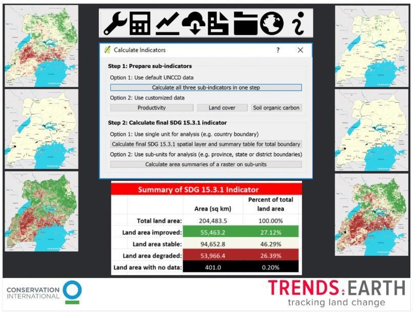
6 Status of indicators for Task Stream#2 (cont d) Indicator UN custodian Tier Current status Way forward Rural population within 2km distance from all-season road Land consumption per population growth Proportion of degraded land per total land World Bank III Report on methodology and data are available. Mexico and Colombia already made country pilots. Satellite EO can monitor condition of roads. UN-Habitat II NASA/ CI in support of EO4SDG (in close engagement w/ UN Habitat & Colombia/ DANE): harmonization of methodological differences (i.e., global metadata to country-specific) and tool development to extend (Trends.Earth: open source, QGIS) UNCCD II Steering Committee established with participation of EO4SDG and three WGs are being formed. CI s Trends.Earth provides a tool for country monitoring, 155 countries already reported. Roles of satellite EO is secondary and its approach needs to be studied. Work on improving the delivery of methods, tools and interpretation of the indicator at the UN Habitat -planned workshops & via direct engagement w/ countries; Support UNCCD through the Steering Committee and WGs 6
 Maturity Availability validated global Completeness")
7 Global EO products in support of SDG indicators Global Surface Water Extent for SDG (water-related ecosystems) Maturity Availability validated global Completeness


8 Global EO products in support of SDG indicators Global Mangrove Watch for SDG (water-related ecosystems) Maturity Availability validated global Completeness 2010

9 Online EcoMap Data Portal Through an ongoing partnership with SERVIR East Africa and the Regional Centre for Mapping of Resources for Development (RCMRD), an EcoMap portal will be made publicly available. EcoMap users will have the capacity to interact with global mangrove loss, loss drivers, vulnerability, and canopy height maps at 30 meter resolution. EcoMap will be available both online and via mobile devices. Fatoyinbo, Goldberg, Lagomasino


10 Electronic Coastal Monitoring and Assessment Program (EcoMap) Mangrove Losses and Gains Land Cover Changes Loss Drivers Mozambique Vietnam Indonesia Canopy Height Aboveground Biomass Total Carbon Stocks Kenya Gabon Senegal


11 Continental Loss Driver Trends NORTH AMERICA Erosion 33% SOUTHEAST ASIA Erosion 10% Dieback 58% Agriculture 39% Dieback 23% SOUTH AMERICA AFRICA Aquaculture 27% OCEANIA Erosion 17% Erosion 37% Dieback 41% Erosion 52% Dieback 63% Dieback 77%


12 Global EO products in support of SDG indicators Vegetated Wetlands Inventories for SDG (water-related ecosystems) Maturity Availability Under validation national cases Completeness 2017/18

")

13 Global EO products in support of SDG indicators Lake Water Quality for SDG and Water Bodies Lake and river water level Lake surface water temperature Lake surface reflectance Lake turbidity Lake trophic state Water Level Maturity Availability Parameters Lake Surface Reflectance (all bands) Lake turbidity Trophic state (based on CHL concentration) Lake Water Temperature needs tailoring 1,000 lakes Coverage 1,000 selected lakes Temporal 10days averages ; ongoing Spatial resolution Evolution 300m, 1km Evolution towards a seamless global product covering all 100m (in evolution) water bodies at 100m resolution Completeness


 Current")


14 Developing a Decision Support Lat =-15.40, Lon = System Example: EI Pañe Reservoir in Perú: water supply for Arequipa city 29 th June th July th August km Time-series corresponds to the marked location (star) Current monitoring: Monthly at 2 locations Sentinel-2B Landsat-8 Sentinel-2A Chlorophyll-a Credit: N. Pahlevan nima.pahlevan@nasa.gov 16
")
 Maturity")
15 Global EO products in support of SDG indicators World Settlement Footprint (WSF) for SDG (sustainable urbanization) Maturity Availability validated global Completeness 2015
 Land Cover Global land Cover Maps, 1992-2015, Annual maps AVHRR, SPOT VGT, ENVISAT MERIS,")
 Maturity coarse resolution")

16 Global EO products in support of SDG indicators Global land cover and land productivity dynamics for SDG (LDN) Land Cover Global land Cover Maps, , Annual maps AVHRR, SPOT VGT, ENVISAT MERIS, MODIS, PROBA-V, Sentinel 3, 300m ESA Land Cover CCI Land Productivity Dynamics LPD derived from NDVI phenological analyses SPOT VEGETATION, 1km EC Joint Research Center (JRC) Maturity coarse resolution Availability global Completeness Monitoring on the status & trends in land degradation is based on sub-indicators: (1) Land Cover and Land Cover Changes (2) Land Productivity (3) Soil Organic Carbon


17 Timeline of Recent Activities with EO4SDG Engagement March 2018 June 2018 July 2018 October 2018 November 2018 March / th IAEG-SDGs Mtg. 4/24-25 UNEP Regional Workshop, Bogota, Colombia 4/ th Global Forum on Urban Resilience and Adaptation 5/2 UN SPB Forum 5/7-12 GEOGLAM RAPP/ SDG/ ARDC Workshop 6/11-12 GEO Symposium 6/17-18 Congress on SDGs - Black Sea Region 6/18-22 UNEP Regional Workshop, Bangkok, 06/27 WGGI Virtual Mtg. 7/9-18 UN HLPF 7/30-8/3 UN-GGIM 8, SDG Training 8/12, RCMRD Conference, SDG training 8/26-31 World Water Week 9/6 IAEG-SDGs Virtual September Mtg. 9/ UN/ Austria Symposium, Space for SDGs 9/ rd UNGA 10/ nd CEOS Plenary 10/22-24 UN World Data Forum /29-11/2 GEO Week /5-8 8 th IAEG-SDGs Mtg. 11/7-9 UNEP SDG Consultation Workshop, Lake Como, Italy 11/19-21 UN World Geospatial Congress 12/6-8 5 th WGGI Mtg. & UN GGIM International Seminar 12/ AGU Fall Meeting 2/18-22 UN Habitat N. Africa/Arab States/W. Asia Workshop 3/ th Session - UN Statistical Commission 3/11-15 UNEA 4 17
18 Task Stream II: Application of satellite EO data for the SDG indicators Task III: Provide recommendation on the role of NSOs on the uptake of analysis-ready satellite earth observations Deliverables Toolkit of effective methods, including statistical practices and uses of geospatial information and fit-for-purpose EO datasets, and examples of use cases.

19 SDG Custodian Indicators Sub- Indicators Custodian s expert group EO in Custodian guidelines EO products UN Environment, Ramsar Change in extent of water-related ecosystems over time Spatial extent of open water bodies Spatial extent of vegetated wetlands Lake Water Quality Other not relevant for EO ESA, NASA, EC/JRC (GSWE), JAXA (GMW) Level 1 includes 2 Sub-Indicators based on EO global data from which will be validated by countries against their own methodologies and datasets. Dynamics of surface waters Vegetated Wetland inventory (with high level classification) Surface Water quality (Chl-a /Trophic State Index, TSM / Turbidity) Source of EO Landsat, Sentinel 1, Sentinel 2, ALOS-2 Palsar-2 (ScanSAR) Palsar-2, Landsat-8, S1, S2 MODIS, VIIRS, S3 OLCI & S2 + L8 Global Datasets EO good practice examples Platforms (with data analytics) S/W Toolbox GEO Initiative Knowledge Hub National Experience Global Surface Water Explorer (GSWE), EC/JRC Global Mangrove Watch (GMW), JAXA Copernicus Global Land Service, Lake Water Quality, EC Examples from SWOS (EC), GW Africa (ESA), EO4SD Water (ESA), other projects GPSSD project in Uganda (wetlands) NASA pilot projects GSWE (global-surface-water.appspot.com) ESA TEP Hydro (hydrology-tep.eo.esa.int) Open Data Cube (free, open source) SWOS Toolbox (free) GlobWetland Africa Toolbox (free, open source) GEO Wetlands GEO Wetlands Portal (in construction) Colombia Australia Others?


20 Towards efficient Collaborative data big exploitation data exploitation platforms
21 SDG Custodian Indicators UN Habitat Ratio of land consumption rate to population growth rate Global Datasets Global Human Settlement Layer (GHSL 2015, 2000, 1990, 1975), EC/JRC World Settlement Footprint (WSF 2015, soon WSF Evolution), DLR/ESA Sub- Indicators Custodian s expert group EO in Custodian guidelines EO products Land consumption rate Population growth EC/JRC (GHSL) Extensive consideration of EO in methodology. The Global Human Settlement Layer (GHSL) open framework is proposed for global open spatial baseline data production (built-up and population grids). Human settlements (built up) Population density (census population data disaggregated with EO) EO good practice examples Platforms (with data analytics) S/W Toolbox GEO Initiative Knowledge Hub Examples from EO4SD Urban (ESA), GEO Human Planet, CIESIN GHSL Portal (GHSL.jrc.ec.europa.eu) ESA TEP Urban (urban-tep.eo.esa.int) CI/NASA Trends.earth (in construction) N/A GEO Human Planet GHSL Portal Source of EO Free: Landsat, Sentinel 1, Sentinel 2, Commercial: WorldView, Pleiades, GeoEye, SPOT 6/7,,TerraSAR-X, Cosmo- Skymed National Experience Colombia Mexico Others?
 & respective indicators Landsat Time Series of Impervious Cover for Bogota, Colombia The value of global urban extent data")


22 EO contributes to many SDG 11 targets, i.e., 11.1 (slums), (planning), 11.6 (air quality/waste management) and 11.7 (urban green/public places) & respective indicators Landsat Time Series of Impervious Cover for Bogota, Colombia The value of global urban extent data sets or global sampling of cities (Atlas of Urban expansion from NYU/Lincoln Institute of Land Policy) are key for global & national level monitoring & reporting There is a need for method comparability, standardization of datasets for indicator production, capacity development at national level, tools and collaborative platforms. Development of tool to asses the ratio of land consumption rate to population growth rate [NASA/CI Collaboration in support of EO4SDG] Trends.Earth leverages Google s Earth Engine platform to integrate EO from multiple sources at user-defined scales and timeframes. Close collaboration w/ UN Habitat & countries.


23 Chart 23 Urban TEP for SDG (Land consumption rate) standardised interfaces (OGC, WPS, WMS)
24 SDG Custodian Indicators Sub- Indicators Custodian s expert group UNCCD Proportion of land that is degraded over total land area Land Cover Change Land Productivity Carbon Stock Change (above and below ground) CSIRO, ESA, NASA, EC/JRC (WAD) Global Datasets EO good practice examples CCI Land Cover, ESA, 300m, , annual WAD / Land Productivity Dynamics, JRC, 1km, AVHRR/GIMMS NDVI, NASA, 8km, MOD13Q1-coll16 NDVI, 250m, SoilGrids 250m Examples from LDN-Target Setting Program (based on CCI LC & JRC LPD) EO in Custodian guidelines Good Practice Guidance (GPG) has been developed by the UNCCD and its partner CSIRO which deeply integrates EO into the methodology (for Land Cover Change and for Land Productivity). Platforms (with data analytics) S/W Toolbox CI Trends.earth Trends.earth (NASA algorithm for Land Productivity, ESA LandCover CCI for LCC) EO products Source of EO Land Cover / Land Cover change Land Productivity (based on NDVI phenology) Land Cover: (300m) MODIS, PROBA-V, S3, soon (20m) Sentinel 2 + Sentinel 1 Land Productivity: (300m) MODIS, PROBA-V, S3, Soon (30m) L8+S2 GEO Initiative Knowledge Hub National Experience GEO Land Degradation Neutrality (with CSIRO, ESA, NASA, JRC, SANSA) N/A Country experience from LDN-Target Setting Program (based on CCI LC & JRC LPD)
25 Task Stream II: Application of satellite EO data for the SDG indicators Organization: The Task Stream II work with all the stakeholders, including UN Custodian Agencies, NSO and its line ministries, academia, civil society, and private sector. Schedule The Task Stream II work through 2020 to support the comprehensive review of the Global Indicator Framework by IAEG-SDGs


26 EO support to SDG implementation Global Datasets Methodo. Guidelines Country Support Capacity Building EO Software Toolboxes EO Knowledge Hub Custodian Agencies National Statistical Offices Governments / Agencies Key Stakeholders Access to global / regional datasets. in the absence of or to complement and enhance, national data sources. countries which face major difficulties in collecting national data Support custodian agencies to develop method. Guidelines for countries. EO Best Practices. Scientifically sound approaches. Product validation. Show Cases. Targeted activities to support NSOs and ministries to report on SDG indicators. Support country level efforts to apply EO to track, monitor and achieve SDGs. Build capacity to exploit EO Training courses Training material on EO best practices Mainly in developing and emerging economies Critical mass of technical centers Free of charge Open source Easy to use EO Processing Toolboxes Thematic Toolboxes Knowledge sharing Facilitate access to satellite data Access to global / regional datasets EO Best practices Method. guidelines Visualisation and Analysis tools On-line processing Toolboxes (e.g. Data Cube) Global Forest Change, UMD Global Surface Wa ters, JRC GUF Toolbox Global Land Cover, Timeseries, ESA Global Urban Footprint, DLR WGCapD
27 Schedule WGGI WGGI#6 IAEG-SDG IAEG-SDG IAEG-SDG UNSC UNSC(NY) UNSC(NY) Task 1 Task 2 Plan Plan Execution Projects Task 3 Report
Working Group on Geospatial Information
 GEO-XIV Plenary Summary Working Group on Geospatial Information 4 th Meeting Lawrence Friedl Argyro Kavvada Group on Earth Observations NASA Earth Science Dec. 6-8, 2017 An intergovernmental organization
8 th Meeting of IAEG-SDGs 5 8 November 2018, Stockholm, Sweden. Meetings. Report
 Meetings 8 th Meeting of IAEG-SDGs Between April 2018 and November 2018, the Working Group on Geospatial Information of the IAEG- SDGs held two online meetings; presented a report to the United Nations
Space for Sustainable Development
 Space for Sustainable Development ESA s contribution to the Where, What, and How of Data Dr. Christoph Aubrecht Directorate of Earth Observation Programmes Science, Applications and Future Technologies
Earth Observations as a Tool To Achieve Sustainable Development Goals
 The image part with relationship ID rid3 was not found in the file. 16/10/2017 Earth Observations as a Tool To Achieve Sustainable Development Goals LI Jing, China GEO On behalf of the Group on Earth Observations
Potential of Earth Observation to address global challenges of cities
 Potential of Earth Observation to address global challenges of cities Copernicus for Future cities workshop, 9 November 2018, Brussels Session III: cities challenges, user needs and innovation paths Marc
EuroGEOSS Protected Areas Pilot
 EuroGEOSS Protected Areas Pilot Max Craglia European Commission Joint Research Centre Part 1: the present MyNatura2000 Mobile app. Awareness raising & volunteered data collection. Natura2000 covers 18%
Economic and Social Council
 United Nations Economic and Social Council Distr.: General 18 July 2016 Original: English Committee of Experts on Global Geospatial Information Management Sixth session New York, 3-5 August 2016 Item 2
The Global Statistical Geospatial Framework and the Global Fundamental Geospatial Themes
 The Global Statistical Geospatial Framework and the Global Fundamental Geospatial Themes Sub-regional workshop on integration of administrative data, big data and geospatial information for the compilation
Geospatial Information and Services for Disasters (GIS4D)
") Geospatial Information and Services for Disasters (GIS4D) 31 July 2017 Tae Hyung KIM ICT and Disaster Risk Reduction Division (IDD) UNESCAP 1 About ESCAP Who is ESCAP? United Nations Economic and Social
Geospatial Information and Services for Disasters (GIS4D) 31 July 2017 Tae Hyung KIM ICT and Disaster Risk Reduction Division (IDD) UNESCAP 1 About ESCAP Who is ESCAP? United Nations Economic and Social
Module 3 Indicator Land Consumption Rate to Population Growth Rate
 Regional Training Workshop on Human Settlement Indicators Module 3 Indicator 11.3.1 Land Consumption Rate to Population Growth Rate Dennis Mwaniki Global Urban Observatory, Research and Capacity Development
RESAP Progress Report
 RESAP Progress Report December 2016 to October 2017 Presentation to the Twenty-first session of the Intergovernmental Consultative Committee on the Regional Space Applications Programme for Sustainable
KUNMING FORUM ON UNITED NATIONS GLOBAL GEOSPATIAL INFORMATION MANAGEMENT CITIES OF THE FUTURE: SMART, RESILIENT
 KUNMING FORUM ON UNITED NATIONS GLOBAL GEOSPATIAL INFORMATION MANAGEMENT CITIES OF THE FUTURE: SMART, RESILIENT and SUSTAINABLE Yunnan Zhenzhuang Guest House, Kunming, China 10 12 May 2017 BACKGROUND CONCEPT
The Combination of Geospatial Data with Statistical Data for SDG Indicators
 Session 3: Sustainable Development Goals, SDG indicators The Combination of Geospatial Data with Statistical Data for SDG Indicators Pier-Giorgio Zaccheddu (with the assistance of Francisco Vala & Cátia
2018/1 The integration of statistical and geospatial information. The Regional Committee of UN-GGIM: Americas:
 The following are the conclusions and recommendations of the Regional Committee of the United Nations on Global Geospatial Information Management for the Americas, during its Fifth Session, Thursday 8
Supporting GPSC Cities with Satellite Earth Observation for Sustainable Urban Development
 Supporting GPSC Cities with Satellite Earth Observation for Sustainable Urban Development Global Platform for Sustainable Cities African Regional Workshop 14 May 2018 AfDB Headquarters Abidjan, Côte d'ivoire
The Combination of Geospatial Data with Statistical Data for SDG Indicators
 Session x: Sustainable Development Goals, SDG indicators The Combination of Geospatial Data with Statistical Data for SDG Indicators Pier-Giorgio Zaccheddu Fabio Volpe 5-8 December2018, Nairobi IAEG SDG
Sustainable Development Goals UN-GGIM Task Team
 Sustainable Development Goals UN-GGIM Task Team Executive Committee Meeting, 1. June 2016 Kristian Møller Copyright 2013 EuroGeographics Developments Creation of the One pager and matrix Reviewed by UN-GGIM:
Developing a global, people-based definition of cities and settlements
 Developing a global, people-based definition of cities and settlements Cooperation between: Directorate General for Regional and, Joint Research Centre, EUROSTAT (European Commission, European Union) OECD,
Space Applications for Disaster Risk Reduction and Sustainable Development
 Space Applications for Disaster Risk Reduction and Sustainable Development Space Applications Section (SAS) ICT and Disaster Risk Reduction Division (IDD) UNESCAP Contents I. RESAP Activities 2016-2017
Economic and Social Council
 United Nation E/C.20/2012/4/Add.1 Economic and Social Council Distr.: General 2 July 2012 Original: English Committee of Experts on Global Geospatial Information Management Second session New York, 13-15
GLOBWETLAND AFRICA TOOLBOX
 The GlobWetland Africa Toolbox is an open source and free-of-charge software toolbox for inventorying, mapping, monitoring and assessing wetlands. The toolbox comes with end-to-end processing workflows
Building Institutional Capacity for Multi-Hazard Early Warning in Asia and the Pacific Subtitle
 Building Institutional Capacity for Multi-Hazard Early Warning in Asia and the Pacific Subtitle Title Keran Wang Chief, Space Applications Section ICT and Disaster Risk Reduction Division 22 May 2018 Pillar
NCAVES - Global initiative and national pilots
 NCAVES - Global initiative and national pilots Kavita Sharma UN Environment Pretoria, March 2018 Outline 1. Global initiative > Introduction > Objectives and deliverables >Activities in 2017 and 2018 2.
Sharthi Laldaparsad Statistics South Africa, Policy Research & Analysis. Sub-regional workshop on integration of administrative data,
 Sub-regional workshop on integration of administrative data, big data and geospatial information for the compilation of SDG indicators and International Workshop on Global Fundamental Geospatial Data Themes
OSS MISSION.
 GEO-CRADLE COORDINATING AND INTEGRATING STATE-OF-THE-ART EARTH OBSERVATION ACTIVITIES IN THE REGION OF NORTH OF AFRICA, MIDDLE EAST, AND BALKANS AND DEVELOPING LINKS WITH GEO RELATED INITIATIVES TOWARD
Spatially Enabled Society
 International Seminar on Land Administration Trends and Issues in Asia and the Pacific Region Spatially Enabled Society Abbas Rajabifard Vice Chair PCGIAP-WG3 Vice-President (President Elect), GSDI Association
ISTAMBUL April 22, pm
 Global Urban Data Initiative ISTAMBUL April 22, 11-12.30 pm Tokyo Ho Chi Minh Moscow Global Urban Data Initiative Global Urban and DRM Unit LEARN ABOUT: Data Access through PUMA Portal and ESA Urban Thematic
IAEG SDGs WG GI, , Mexico City
 IAEG SDGs WG GI, 12-14.12.2016, Mexico City UN-GGIM:Europe s perspective and activities to support better integration of geospatial information and statistics and the UN SDG monitoring Pier-Giorgio Zaccheddu,
Report of the Regional Committee of UN-GGIM for Asia and the Pacific (UN-GGIM-AP)
") Report of the Regional Committee of UN-GGIM for Asia and the Pacific (UN-GGIM-AP) At the Eighth Session of UN-GGIM UN Headquarters, New York, 1 3 August 2018 About UN-GGIM-AP One of the five regional committees
Report of the Regional Committee of UN-GGIM for Asia and the Pacific (UN-GGIM-AP) At the Eighth Session of UN-GGIM UN Headquarters, New York, 1 3 August 2018 About UN-GGIM-AP One of the five regional committees
Economic and Social Council
 United Nations Economic and Social Council Distr.: General 2 July 2012 E/C.20/2012/10/Add.1 Original: English Committee of Experts on Global Geospatial Information Management Second session New York, 13-15
Earth Observation for Sustainable Development to Support Land Use Planning in Urban Areas
 Background Image Source bbc.co.uk Human Planet 2011 BBC Earth Observation for Sustainable Development to Support Land Use Planning in Urban Areas Thomas Häusler, Sharon Gomez, Fabian Enssle GAF AG Land
Building Stronger Data Ecosystems to Address SDGs Data Needs
 Building Stronger Data Ecosystems to Address SDGs Data Needs Data Science in Africa Workshop @ the African University of Science and Technology, Abuja Nov. 15, 2018 The Global Sustainable Development Goals
Development of a Regional Land Cover Monitoring System In the Lower Mekong Region a Joint Effort Between SERVIR-Mekong and Partners -
 Mekong Development of a Regional Land Cover Monitoring System In the Lower Mekong Region a Joint Effort Between SERVIR-Mekong and Partners - Aekkapol Aekakkararungroj SERVIR-Mekong Asian Disaster Preparedness
Building Institutional Capacity for Multi-Hazard Early Warning in Pacific Countries Subtitle
 Building Institutional Capacity for Multi-Hazard Early Warning in Pacific Countries Subtitle Title Keran Wang Chief, Space Applications Section ICT and Disaster Risk Reduction Division 30 March 2018 Slide
Bengt Kjellson Chair of the Executive Committee UN-GGIM: Europe. 2 nd Joint UN-GGIM: Europe ESS Meeting 11 th March 2016, Luxembourg
 Bengt Kjellson Chair of the Executive Committee UN-GGIM: Europe 2 nd Joint UN-GGIM: Europe ESS Meeting 11 th March 2016, Luxembourg A global geospatial mandate At its 47th plenary in July 2011, ECOSOC,
Global City Definition
 Regional Training Workshop on Human Settlement Indicators Global City Definition Dennis Mwaniki Global Urban Observatory, Research and Capacity Development Branch, UN-Habitat Bangkok, Thailand Outline
Improving rural statistics. Defining rural territories and key indicators of rural development
 Improving rural statistics Defining rural territories and key indicators of rural development Improving rural statistics Improving Rural Statistics In 2016, the Global Strategy to improve Agricultural
Challenges and Successes in Sharing Geospatial Data in Africa
 Challenges and Successes in Sharing Geospatial Data in Africa 2018 GeoNode Summit Torino, Italy March 26-28, 2018 Bernard Justus Muhwezi Manager, Geo-Information Services Uganda Bureau of Statistics, Kampala,
Developing a global, peoplebased definition of cities and settlements
 Developing a global, peoplebased definition of cities and settlements By Lewis Dijkstra, Lewis.Dijkstra@ec.europa.eu Head of the Economic Analysis Sector DG for Regional and Urban Policy, Regional & Urban
Implementing the Sustainable Development Goals: The Role of Geospatial Technology and Innovation
 Fifth High Level Forum on UN Global Geospatial Information Management Implementing the Sustainable Development Goals: The Role of Geospatial Technology and Innovation 28-30 November 2017 Sheraton Maria
EAGLE Data Model and Outcomes of HELM (Harmonised European Land Monitoring)
") EAGLE Data Model and Outcomes of HELM (Harmonised European Land Monitoring) Contribution towards better land information harmonisation and INSPIRE compliance EAGLE working group Stephan Arnold, Barbara
EAGLE Data Model and Outcomes of HELM (Harmonised European Land Monitoring) Contribution towards better land information harmonisation and INSPIRE compliance EAGLE working group Stephan Arnold, Barbara
Land Use / Land Cover Mapping in
 Land Use / Land Cover Mapping in Eastern and Southern African Regions RCMRD Experience by 6/24/2013, Nairobi Kenya Dr. Tesfaye Korme Director of RS, GIS and Mapping, RCMRD I. About RCMRD, Its Vision and
SWOS (The Satellite-based Wetland Observation Service) Satellite images for peatland monitoring and management Kathrin Weise, Jena-Optronik GmbH
 Satellite images for peatland monitoring and management Kathrin Weise, Jena-Optronik GmbH") This project has received funding from the European Union s Horizon 2020 research and innovation programme under grant agreement No 642088 SWOS (The Satellite-based Wetland Observation Service) Satellite
This project has received funding from the European Union s Horizon 2020 research and innovation programme under grant agreement No 642088 SWOS (The Satellite-based Wetland Observation Service) Satellite
From PCGIAP to UN GGIM AP: A Regional Perspective on GGIM
 Regional Committee of United Nations Global Geospatial Information Management for Asia and the Pacific (UN-GGIM-AP) Established by a United Nations Resolution From PCGIAP to UN GGIM AP: A Regional Perspective
The European Commission s science and knowledge service. Joint Research Centre
 The European Commission s science and knowledge service Joint Research Centre Global Urbanisation Pattern observed with EO data Thomas Kemper & GHSL team Urban Studies Symposium, University of Twente,
UN-GGIM: Europe Work Group on Data Integration. Facilitating the wider utilization of geospatial information to produce indicators
 UN-GGIM: Europe Work Group on Data Integration Facilitating the wider utilization of geospatial information to produce indicators IAEG SDG WG GI, Meeting 06-08.12.2018, NY Copyright 2013 EuroGeographics
KENYA NATIONAL BUREAU OF STATISTICS Workshop on
 KENYA NATIONAL BUREAU OF STATISTICS Workshop on Capacity Building in Environment Statistics: the Framework for the Development of Environment Statistics (FDES 2013) Coordination with Sector Ministries
1) United Nations Committee of Experts on Global Geospatial Information Management (UN-GGIM)
 United Nations Committee of Experts on Global Geospatial Information Management (UN-GGIM)") International Workshop on Legal and Policy Frameworks for Geospatial Information Management Licensing of Geospatial Information 7 9 November 2017 Tianjin Zhengxie Club Hotel Tianjin, China Outline of presentation
International Workshop on Legal and Policy Frameworks for Geospatial Information Management Licensing of Geospatial Information 7 9 November 2017 Tianjin Zhengxie Club Hotel Tianjin, China Outline of presentation
Geospatial activities during the 47 th UN Statistical Commission
 Geospatial activities during the 47 th UN Statistical Commission A Summary Rolando Ocampo Alcántar April 2016 47 th Session of the United Nations Statistical Commission Side Events Friday Seminar on Emerging
Programme. MC : Byron Anangwe. Morning Session
 Programme MC : Byron Anangwe Morning Session DAY 2 Summary MC : Byron Anangwe The USGS global land cover mapping initiative Land use and land cover mapping at the Joint Research Centre Alan Belward FAO
Faatasi Malologa (PGSC Chair) Director Department of Lands & Survey, Tuvalu
 Director Department of Lands & Survey, Tuvalu") Seventh Session of the United Nations Committee of Experts on Global Geospatial Information Management (UN-GGIM) - 31 July -4 August 2017 Faatasi Malologa (PGSC Chair) Director Department of Lands & Survey,
Seventh Session of the United Nations Committee of Experts on Global Geospatial Information Management (UN-GGIM) - 31 July -4 August 2017 Faatasi Malologa (PGSC Chair) Director Department of Lands & Survey,
UN GGIM and National SDI Strategy
 MSDI Open Forum on 26 th January 2016 Contributing to the successful delivery of MSDI UN GGIM and National SDI Strategy Hiroshi Murakami Deputy Administrator Geospatial Information Authority of Japan Geospatial
From GlobWetland II to GlobWetland Africa
 From GlobWetland II to GlobWetland Africa STRP 18, Gland, September 2014 Marc Paganini, European Space Agency Directorate of Earth Observations Programs Where can EO technology play a role? Wetlands Inventory:
Arctic Spatial Data Infrastructure Enabling Access to Arctic Location-Based Information
 Arctic Spatial Data Infrastructure Enabling Access to Arctic Location-Based Information Arctic SDI Side Event Co-Chairs: Arvo Kokkonen Arctic SDI Board Chair & Director General, National Land Survey of
Remote Sensing products and global datasets. Joint Research Centre, European Commission
 Remote Sensing products and global datasets Joint Research Centre, European Commission Setting the stage. Needs and requirements for integrated approach(es) for land degradation assessment. in Special
Earth Observation and GEOSS in Horizon Copernicus for Raw Material Workshop 5 th September 2016
 Earth Observation and GEOSS in Horizon 2020 Copernicus for Raw Material Workshop 5 th September 2016 Gilles OLLIER Head of Sector -Earth observation Directorate Environment Unit I.4 Climate Actions and
Geospatial Monitoring of the SDGs
 Geospatial Monitoring of the SDGs Sharing experiences on indicator 6.6.1 on freshwater related ecosystems, and exploring opportunities for better monitoring of the land water ocean nexus INEGI Dirección
International Workshop on Legal and Policy Frameworks for Geospatial Information Management: Licensing of Geospatial Information
 United Nations Committee of Experts on Global Geospatial Information Management International Workshop on Legal and Policy Frameworks for Geospatial Information Management: Licensing of Geospatial Information
Economic and Social Council
 United Nations Economic and Social Council Distr.: General 19 December 2018 Original: English Statistical Commission Fiftieth session 5 8 March 2019 Item 3 (o) of the provisional agenda* Items for discussion
UN Work on Geospatial Information in Support of Sustainable Development:
 Consultative Meeting on the Implementation Framework for the Environmental Dimension of the 2030 Agenda in the Arab Region Cairo, Egypt, 18-20 Sep 2017 UN Work on Geospatial Information in Support of Sustainable
Background Document: Report of the Regional Committee of United Nations Global Geospatial Information Management for Asia and the Pacific
 Background Document: Report of the Regional Committee of United Nations Global Geospatial Information Management for Asia and the Pacific 1. Summary 1. This report highlights the activities carried out
GCOS High Resolution Land Cover ECV. Slide 11
 GCOS High Resolution Land Cover ECV Slide 11 Detailed Land Cover and Climate Land cover and its changes modify the goods and services provided to human society force climate by altering water and energy
Copernicus Overview. Major Emergency Management Conference Athlone 2017
 Copernicus Overview Major Emergency Management Conference Athlone 2017 Copernicus is a European programme implemented by the European Commission. The services address six thematic areas: land, marine,
Realizing benefits of Spatial Data Infrastructure A user s perspective from Environment Agency - Abu Dhabi
 Realizing benefits of Spatial Data Infrastructure A user s perspective from Environment Agency - Abu Dhabi Anil Kumar Director, Environment Information Management 26 April 2012 Geospatial World Forum,
Measuring and Monitoring SDGs in Portugal: Ratio of land consumption rate to population growth rate Mountain Green Cover Index
 Measuring and Monitoring SDGs in Portugal: 11.3.1Ratio of land consumption rate to population growth rate 15.4.2 Mountain Green Cover Index United Nations World Geospatial Information Congress João David
Observation (EO) & Geomatics in Canada
 & Geomatics in Canada") Innovating to Increase the Impact of Earth Observation (EO) & Geomatics in Canada Natural Resources Canada February 25, 2014 Prashant Shukle, Director General Canada Centre for Mapping and Earth Observation
Innovating to Increase the Impact of Earth Observation (EO) & Geomatics in Canada Natural Resources Canada February 25, 2014 Prashant Shukle, Director General Canada Centre for Mapping and Earth Observation
UN-GGIM: An Overview Stefan Schweinfest, Director (UNSD) Bangkok, 27 March 2015
 Bangkok, 27 March 2015") UN-GGIM: An Overview Stefan Schweinfest, Director (UNSD) Bangkok, 27 March 2015 ggim.un.org UN-GGIM: A global initiative Formal inter-governmental UN Committee of Experts to: Discuss, enhance and coordinate
UN-GGIM: An Overview Stefan Schweinfest, Director (UNSD) Bangkok, 27 March 2015 ggim.un.org UN-GGIM: A global initiative Formal inter-governmental UN Committee of Experts to: Discuss, enhance and coordinate
Introduction of the Asia-Oceania Global Earth Observation System of Systems (AOGEOSS) GEO Initiative(GI-22 )
 GEO Initiative(GI-22 )") Introduction of the Asia-Oceania Global Earth Observation System of Systems (AOGEOSS) GEO Initiative(GI-22 ) Prof. Xiang ZHOU Institute of Remote Sensing and Digital Earth, CAS 11 May 2017 Kunming, China
Introduction of the Asia-Oceania Global Earth Observation System of Systems (AOGEOSS) GEO Initiative(GI-22 ) Prof. Xiang ZHOU Institute of Remote Sensing and Digital Earth, CAS 11 May 2017 Kunming, China
Colin Bray, OSi CEO. Articulating the Data Needs for SDGs. Collaboration in Ireland
 Ireland Colin Bray, OSi CEO Articulating the Data Needs for SDGs Collaboration in Ireland Articulating the Data Needs for SDGs Ireland Introduction Collaboration between the Irish National Mapping Agency
The Polar Ice Sheets Monitoring Project A Coordinated Response from Space Agencies
 The Polar Ice Sheets Monitoring Project A Coordinated Response from Space Agencies Yves Crevier / Members of the PSTG SAR Coordination WG Canadian Space Agency CEOS SIT-28 Meeting Hampton, Virginia, USA
Empowered lives. Resilient nations. Data for People and Planet. powered by
 Empowered lives. Resilient nations. Data for People and Planet powered by Overview As we enter the fourth industrial revolution, technology is revolutionizing our ability to map nature. Satellite data
Achieving the Vision Geo-statistical integration addressing South Africa s Developmental Agenda. geospatial + statistics. The Data Revolution
 Achieving the Vision Geo-statistical integration addressing South Africa s Developmental Agenda geospatial + statistics The Data Revolution humble beginnings, present & future - South Africa UN World Data
Space Application in Support of Land Management for SDG Implementation
 Space Application in Support of Land Management for SDG Implementation Regional Expert Workshop on Land Accounting for SDG Monitoring and Reporting 26 September 2017 Space Application Section Information
SDG s and the role of Earth Observation
 SDG s and the role of Earth Observation Christian Heipke IPI - Institute for Photogrammetry and GeoInformation Leibniz Universität Hannover Germany Secretary General, ISPRS 1. No Poverty 2. Zero Hunger
Mapping Water Resources and Reservoirs for Climate Resilience in Zambezi River Basin
 Mapping Water Resources and Reservoirs for Climate Resilience in Zambezi River Basin Corné van der Sande, NEO BV Senior Advisor Earth Observation Services for Monitoring Drought and Water Resources in
Capacity building and the global human settlement data. Richard Sliuzas, University of Twente Vincent Seaman, Bill & Melinda Gates Foundation
 Capacity building and the global human settlement data Richard Sliuzas, University of Twente Vincent Seaman, Bill & Melinda Gates Foundation Content Capacity development Capabilities approach Some issues
THE ROLE OF GEOSPATIAL AT THE WORLD BANK
 THE ROLE OF GEOSPATIAL AT THE WORLD BANK INSPIRE Conference Barcelona, Spain September 26, 2016 Kathrine Kelm Senior Land Administration Specialist Global Land and Geospatial Unit The World Bank Group
Concept note. High-Level Seminar: Accelerating Sustainable Energy for All in Landlocked Developing Countries through Innovative Partnerships
 Concept note High-Level Seminar: Accelerating Sustainable Energy for All in Landlocked Developing Countries through Innovative Partnerships Date: 24 and 25 October 2016 Venue: Conference Room C3, Vienna
WMO Priorities and Perspectives on IPWG
 WMO Priorities and Perspectives on IPWG Stephan Bojinski WMO Space Programme IPWG-6, São José dos Campos, Brazil, 15-19 October 2012 1. Introduction to WMO Extended Abstract The World Meteorological Organization
Geospatial workflows and potential applications to the Sustainable Development Goals of countries in West Asia
 Geospatial workflows and potential applications to the Sustainable Development Goals of countries in West Asia Ameer Abdulla, PhD Senior Advisor, European Topic Center for Spatial Analysis, Spain Associate
African requirements for SDI standardization Antony Cooper Operating Unit Fellow Built Environment CSIR PO Box 395, Pretoria, 0001, South Africa
 ISO/TC 211 workshop on spatial data infrastructures (SDIs) African requirements for SDI standardization Antony Cooper Operating Unit Fellow Built Environment CSIR PO Box 395, Pretoria, 0001, South Africa
Integration for Informed Decision Making
 Geospatial and Statistics Policy Intervention: Integration for Informed Decision Making Greg Scott Global Geospatial Information Management United Nations Statistics Division Department of Economic and
The Global Fundamental Geospatial Data Themes Journey. April Clare Hadley WG Chair
 The Global Fundamental Geospatial Data Themes Journey April 2018 Clare Hadley WG Chair The Road to here Why Global? Why Geospatial? Why Fundamental? Why Themes? The route we took Where does the road go
Swedish examples on , and
 Swedish examples on 11.2.1, 11.3.1 and 11.7.1 Marie Haldorson, Director Seminar in Nairobi 7 Dec 2018 SDG Indicator Tests by Countries in Europe GEOSTAT 3: ESS Project with a purpose to guide countries
Development of Global Map for GEOSS SBAs US-09-03a
 Development of Global Map for GEOSS SBAs US-09-03a UIC User Engagement Session 2 November, 2010 Yoshikazu FUKUSHIMA Secretariat General of International Steering Committee for Global Mapping Geospatial
Indicator : Average share of the built-up area of cities that is open space for public use for all, by sex, age and persons with disabilities
 Goal 11: Make cities and human settlements inclusive, safe, resilient and sustainable Target 11.7: By 2030, provide universal access to safe, inclusive and accessible, green and public spaces, in particular
Land Accounts - The Canadian Experience
 Land Accounts - The Canadian Experience Development of a Geospatial database to measure the effect of human activity on the environment Who is doing Land Accounts Statistics Canada (national) Component
Discussion paper on spatial units
 Discussion paper on spatial units for the Forum of Experts in SEEA Experimental Ecosystem Accounting 2018 Version: 8 June 2018 Prepared by: SEEA EEA Revision Working Group 1 on spatial units (led by Sjoerd
Utilization of Global Map for Societal Benefit Areas
 Utilization of Global Map for Societal Benefit Areas The Fourth GEOSS AP Symposium Bali Indonesia, 11th March 2010 Shuhei Kojima Geographical Survey Institute Ministry of Land, Infrastructure, Transport
Committee on Earth Observation Satellites. The CEOS Volcano Demonstrator Rationale and Implementation
 Committee on Earth Observation Satellites The CEOS Volcano Demonstrator Rationale and Implementation Why focus on volcanoes? Over 300,000 people have been killed by volcanoes since the 1600s Globally,
UN-GGIM:Americas Regional Report
 UN-GGIM:Americas Regional Report 2016-2017 Seventh Session of UN-GGIM 2-4 August 2017, United Nations Headquarters, New York. Rolando Ocampo President of UN-GGIM: Americas Content Activities, Areas of
AAG Partnerships for. Sustainable Development in Africa: Geospatial Science & Technology for. Partnerships and Applications
 AAG Partnerships for Sustainable Development in Africa Geospatial Science & Technology for Sustainable Development in Africa: Partnerships and Applications Harvard University John F. Kennedy School of
MANUAL ON THE BSES: LAND USE/LAND COVER
 6. Environment Protection, Management and Engagement 2. Environmental Resources and their Use 5. Human Habitat and Environmental Health 1. Environmental Conditions and Quality 4. Disasters and Extreme
National Remote Sensing Center of China. Space Technology for Sustainable Development in China Status, Achievements and Futures.
 National Remote Sensing Center of China Space Technology for Sustainable Development in China Status, Achievements and Futures Jing Li National Remote Sensing Center of China Ministry of Science and Technology,
U s i n g t h e E S A / E U M E T C A S T N a v i g a t o r s
 U s i n g t h e E S A / E U M E T C A S T N a v i g a t o r s Copernicus User Uptake Information Sessions Copernicus EU Copernicus EU Copernicus EU www.copernicus.eu I N T R O D U C T I O N O F U S E C
Indicator: Proportion of the rural population who live within 2 km of an all-season road
 Goal: 9 Build resilient infrastructure, promote inclusive and sustainable industrialization and foster innovation Target: 9.1 Develop quality, reliable, sustainable and resilient infrastructure, including
GEO Work Programme GEO Initiative on Land Degradation Neutrality GEO LDN Initiative
 GEO Work Programme 2017-2019 GEO Initiative on Land Degradation Neutrality GEO LDN Initiative Table of Contents Executive Summary 2 1. Synopsis of objectives and benefits 3 2. Relationship to previous
UNITED NATIONS GEOGRAPHIC INFORMATION WORKING GROUP
 UNGIWG UNITED NATIONS GEOGRAPHIC INFORMATION WORKING GROUP New York, May 2014 UNSPACE & UNGIWG 14 INTRO. The United Nations Geographic Information Working Group (UNGIWG) is a voluntary network of UN professionals
Georeferencing and Satellite Image Support: Lessons learned, Challenges and Opportunities
 Georeferencing and Satellite Image Support: Lessons learned, Challenges and Opportunities Shirish Ravan shirish.ravan@unoosa.org UN-SPIDER United Nations Office for Outer Space Affairs (UNOOSA) UN-SPIDER
Spanish national plan for land observation: new collaborative production system in Europe
 ADVANCE UNEDITED VERSION UNITED NATIONS E/CONF.103/5/Add.1 Economic and Social Affairs 9 July 2013 Tenth United Nations Regional Cartographic Conference for the Americas New York, 19-23, August 2013 Item