International Law in the South China Sea
|
|
|
- Clifford Wright
- 5 years ago
- Views:
Transcription


1 International Law in the South China Sea The Philippines-China Dispute Luz Danielle O. Bolong Harvard Law School April 2, 2014 Award on Jurisdiction, Figure 1 (citing RP Memorial, Figure 2.1; amti.csis.org photos
2 Coverage Type of Dispute Relevant UNCLOS provisions The Philippines-China Maritime Dispute Award on Jurisdiction and Admissibility Discussion of Claims Participation of other States What is next?
 China, Philippines, Malaysia, Viet Nam, Brunei, Taiwan (Spratlys) Maritime Disputes Overlapping maritime zones Interpretation or")
3 What disputes? Territorial Disputes Sovereignty China v. Viet Nam (Paracel) China v. Philippines (Scarborough) China, Philippines, Malaysia, Viet Nam, Brunei, Taiwan (Spratlys) Maritime Disputes Overlapping maritime zones Interpretation or application of the UNCLOS Philippines v. China What is UNCLOS? constitution of the oceans


4 What are the different zones under UNCLOS? Schofield s presentation, 2014 Yeosu Academy
5 What are the qualifications for entitlement to territorial sea, EEZ & continental shelf? Criteria Island Rocks Low-tide Elevations and Submerged banks Artificial island, installations and structures Entitlement TS, EEZ, CS TS if it cannot sustain human habitation or economic life Description Naturally formed area of land surrounded by water and above water at high tide Subcategory of islands. None but may be used as baseline if situated within 12 nm from mainland or an island Naturally formed area of land surrounded by and above water at low tide but submerged at high tide None but may have safety zone around it not exceeding 500 meters. Do not affect delimitation Not naturally formed; with human, mechanical or other unnatural intervention. Not considered as permanent harbor works UNCLOS provision Art. 121 Art. 121(3) Art. 13 Arts. 60, 11


6 What is a rock? Counter-Memorial of Colombia, Figure ;

7 What is the bottom line? To reduce the nine-dash line claim into donuts. Award on Jurisdiction, Figure 5 (citing RP Memorial, Figure 4.2)
8 Maritime Dispute in a gist China Philippines UNCLOS We have sovereignty and sovereign rights over all of South China Sea. At most, features in South China Sea are all rocks entitled to just 12 nm territorial Sea. We have sovereign rights within our EEZ. Outside those donuts, as long as it is within our 200 nm, you cannot interfere with our UNCLOS rights. Rights depends on characterization of features island, rock or low-tide elevation.
9 Can the tribunal hear the case? China s absence does not bar the proceedings. Tribunal considered, although did not confine itself to, issues in China s position paper. China s Objection 1: Arbitration essentially dwells on territorial sovereignty, outside UNCLOS scope. Tribunal says: Presence of other aspects to a dispute not ground to decline dispute on another aspect. Jurisdiction over submissions related to environmental harm. Narrow selection of features does not affect China s sovereignty.
10 Can the tribunal hear the case? China s Objection 2: Assuming within scope, part of maritime delimitation that China excluded in Tribunal says: Dispute over an issue considered during maritime boundary delimitation does not by itself constitute maritime boundary delimitation. China s Objection 3: The Philippines violated obligation to settle disputes through negotiations. Tribunal says: Resort to arbitration not by itself abuse of rights China-ASEAN Code of Conduct does not preclude compulsory settlement of dispute procedures.
11 Philippines position 1. China s nine-dash line is invalid. China does not have historic rights over the South China Sea. a. China s claims relate to historic rights not to historic title. b. Historic rights do not survive UNCLOS. c. Even if they survive China fails to meet the 3-fold test. 2. Since the maritime features in the South China Sea are either just rocks or low-tide elevations, none of them are entitled to an EEZ, Continental Shelf. 3. China violates its environmental obligations. 4. China violates the Philippines sovereign rights.
12 #1. China has no Historic Rights A. China claims historic rights, not historic title China s claims relate to sovereign rights not sovereignty. Exclusion of historic bays or titles does not apply. China has not used Art. 298(1)(a) as basis for lack of jurisdiction. B. Historic rights do not survive UNCLOS Even before UNCLOS, no support for historic rights Incompatible with UNCLOS (go back to chart)
13 #1. China has no Historic Rights C. China fails to meet three-fold test Absence of claim for over 900 years. Continuous objection from adjacent States What is the basis of the Philippines to say China has not claimed the South China Sea for over 900 years? Maps Legislations Tolerance of activities of other States

14 1136: Hua Yi Tu (Map of China and the Barbarians) Earliest Chinese map Philippines knows Southern most part: Hainan

15 Universal Map of the Great Ming Empire Navigation aversion. 14 th century ban on long-range navigation 1500: capital offense to build two-mastered ships 1525: destruction of ships 1551: venturing at sea as act of treason

16 : Territorial Atlas of the Great Ming Empire

 Java (Indonesia)")
17 1721-2: Provincial Atlas- Southern Guangdong Province Aversion continues. 1717: Prohibition to venture into South China Sea places Luzon (Philippines) Java (Indonesia)

18 1842: Qing Empire s Complete Map or All Under Heaven No objection. Surveys (including Spratlys) Claims on Spratly and Amboyna Cay. Anti-piracy measures East Indian company: other vessels larger and more valuable than Chinese vessels.

19 1896: Qing s Empire Complete Map of all Provinces Ming to Qing dynasty: no record of Chinasanctioned activities in South China Sea

20 The change begins in 1933: New Provincial Map of China Taiwan president Ma: China s claims of "sovereignty over the South China Sea islands" date only to the "early 20th century" 1933: inclusion of Paracels Century before: Viet Nam
21 And then things changed 1935: Map including Spratlys 1947: Eleven-dash line: Map showing the Location of the Various Islands in the SCS 1958: 12 nm territorial sea claim for mainland China, Hainan, Taiwan, Pratas, Paracels and Spratlys 1992: Territorial Sea and Contiguous Zone Law 1998: EEZ and Continental Shelf Act ( not affect historic rights ) 2009: historic rights on water within nine-dash line
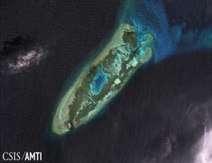
22 # 2. None of the South China Sea features are full-islands entitled to an EEZ and a continental shelf A. Low-tide elevations (below sea level at high tide) Rule: within territorial sea, part of sovereignty; within continental shelf, part of sovereign rights Charts from Philippines, China, Malaysia, Viet Nam, UK, US all agree these are low-tide elevations Those part of the Philippine continental shelf Mischief Reef Second Thomas Shoal Not located in China s/philippines continental shelf Subi Reef Within 12 nm from high-tide features of Viet Nam Gaven Reef [from Namyit] McKennan Reef (including Hughes Reef) [from Sin Cowe]
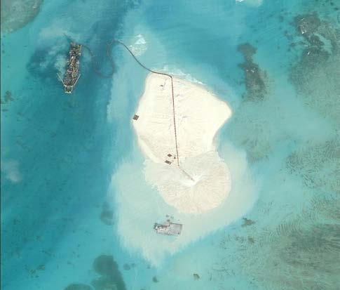
23 # 2. None of the South China Sea features are full-islands entitled to an EEZ and a continental shelf B. Rocks (above sea level at high tide) Recall: 12 nm territorial sea only Scarborough Shoal Johnson Reef Cuarteron Reef Fiery Cross What has China done with these low-tide elevations and rocks? From low-tide features and miniscule rocks to artificial islands From standing capacity to airports


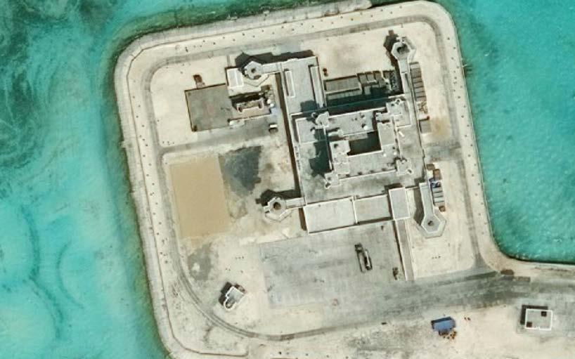
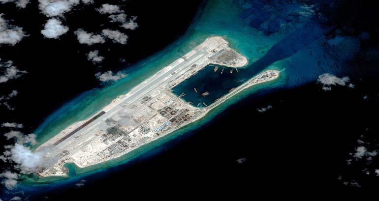
24 amti.csis.org photos Massive construction: Mischief Reef


25 Massive construction: Subi Reef July 2012 Aug Nov June 2015 amti.csis.org photos Jan. 2016


26 Massive construction: Gaven Reef Sept Oct Nov amti.csis.org photos Feb. 2016


27 Massive construction: Hughes Reef Dec Mar amti.csis.org photos Feb. 2016


28 Massive construction: Johnson Reef Jan Nov Nov Jan amti.csis.org photos Feb. 2016


29 Massive construction: Cuarteron Reef Mar Nov Sept amti.csis.org photos Jan. 2016


30 Massive construction: Fiery Cross Jan Nov Sept amti.csis.org photos. Sept. 2015
31 # 3. China violates its environmental obligations Violates obligation to protect and preserve the marine environment. Why is China constructing? Chinese MFA: Main purpose is to better safeguard territorial sovereignty and maritime rights and interests. No information whether China conducts environmental impact assessments (EIA) before constructing. Adverse effects of sand dredging and island-construction to marine ecosystem Other activities: widespread blast fishing; extraction of coral, giant clams, turtles et al endangered species
32 # 4. China violates the Philippines Sovereign Rights Prevents oil exploration and exploitation Sterling Energy PLC (UK) near Reed Bank (service contract), Nido Petroleum Limited (survey), offer of 2 blocks Prevents seismic surveys MV Veritas Voyager near Reed Bank Imposes bans on fishing and requires consent from Hainan authorities Threatens navigation (collision) Threatens rotation and re-supply to Philippine contingency in Second Thomas Shoal
33 Other States are interested in case Viet Nam Supports tribunal s jurisdiction. Resolutely protests and rejects PRC s nine-dash line. Reserves right to intervene. Other Observers Indonesia Malaysia Japan Thailand Brunei Australia Singapore Why relevant? Opens opportunity for greater cooperation and for a united stand on rule of law, from navigation to environmental protection to oil and gas investments
34 What is next? How will the tribunal decide? Favorable Nine-dash line invalid. Features are either low-tide elevations or rocks. Maximum entitlement is just 12 nm. China violates its environmental obligation. China violates the Philippines sovereign rights. Finding some high-tide features as islands. Unfavorable Tribunal no power to hear historical title. Nine-dash line valid. China does not violate its environmental obligations. Regardless of the result, it will definitely clarify the extent of Philippine and Chinese sovereign rights.
35 What is next? Philippine security Fishing Oil and gas exploration Other sovereign rights to its exclusive economic zone How to guarantee compliance? Claimant States: multilateral platform for negotiation with China Common ASEAN stand to recognize decision Neighboring States and world community stand to ensure compliance with freedom of navigation and environmental protection
36 What can we take away from this case? The Philippines v. China case is not about blaming or shaming or antagonizing a neighbor State. It is about the rule of law and its full realization through cooperation.
Captain J. Ashley Roach, JAGC, USN (retired) Office of the Legal Adviser U.S. Department of State (retired) Visiting Senior Principal Research Fellow
 Office of the Legal Adviser U.S. Department of State (retired) Visiting Senior Principal Research Fellow") Captain J. Ashley Roach, JAGC, USN (retired) Office of the Legal Adviser U.S. Department of State (retired) Visiting Senior Principal Research Fellow Centre for International Law NUS Singapore SCS Award
Captain J. Ashley Roach, JAGC, USN (retired) Office of the Legal Adviser U.S. Department of State (retired) Visiting Senior Principal Research Fellow Centre for International Law NUS Singapore SCS Award
GeomaticsWorld. Issue No 3 : Volume 21. Helping to unravel Easter Island s mysterious statues. DGI 2013: maritime security highlighted
 GeomaticsWorld MARCH APRIL 2013 Issue No 3 : Volume 21 BIM: repeat the message even if you lose the will to live Helping to unravel Easter Island s mysterious statues DGI 2013: maritime security highlighted
xxv PART I THE DIVIDED OCEANS: INTERNATIONAL LAW GOVERNING JURISDICTIONAL ZONES 1
 Contents Preface page xv List of Figures xvii List of Tables xviii List of Abbreviations xix Table of Cases xxi Table of Treaties and Instruments xxv PART I THE DIVIDED OCEANS: INTERNATIONAL LAW GOVERNING
Some Thoughts on Maritime Delimitation among the Northeast Asian States
 Some Thoughts on Maritime Delimitation among the Northeast Asian States Seokwoo LEE Assistant Professor College of Law INHA University Korea leeseokwoo@inha.ac.kr 1 I. Common geographical features II.
The Relevance of Hydrography to UNCLOS; an Indonesian Perspective By: Prof. Dr. Hasjim Djalal, MA*
 The Relevance of Hydrography to UNCLOS; an Indonesian Perspective By: Prof. Dr. Hasjim Djalal, MA* As I understand it, the theme of this 6 th ABLOS Conference 2010 is Contentious Issues in UNCLOS- surely
Sam Bateman and. State Practice Regarding Straight Baselines In East Asia Legal, Technical and Political Issues in a
 State Practice Regarding Straight Baselines In East Asia Legal, Technical and Political Issues in a Changing Environment Sam Bateman and Clive Schofield The Australian National Centre for Ocean Resources
Sharing the Resources of the South China Sea
 Sharing the Resources of the South China Sea MARK J. VALENCIA Senior Fellow, East-West Center, Honolulu, Hawaii, U.SA. JON M. VAN DYKE Professor oflaw, Wm. S. Richardson School oflaw, University of Hawaii,
Maritime Boundary Issues Singapore Workshop: Session 4
 Maritime Boundary Issues Singapore Workshop: Session 4 How States deal with factors that can affect boundary negotiations Dr. Robert W. Smith Independent Geographic Consultant U.S. Department of State
MARITIME ZONES FROM ISLANDS AND ROCKS. Paper by Professor Clive R. Symmons for the CIL Roundtable Singapore June 2013
 MARITIME ZONES FROM ISLANDS AND ROCKS Paper by Professor Clive R. Symmons for the CIL Roundtable Singapore June 2013 Basic Definition and Zone-Creating Capacity of an Island in IL . See Art 121(2) UNCLOS:
ROCKS V. ISLANDS: NATURAL TENSIONS OVER ARTIFICIAL FEATURES IN THE SOUTH CHINA SEA. F. Shannon Sweeney*
 ROCKS V. ISLANDS: NATURAL TENSIONS OVER ARTIFICIAL FEATURES IN THE SOUTH CHINA SEA F. Shannon Sweeney* ABSTRACT This Note examines the international arbitration proceeding commenced on January 22, 2013
Law of the Sea Symposium, February, 2016, TOKYO International Law for the Resources of the Sea
 Law of the Sea Symposium, 16-17 February, 2016, TOKYO International Law for the Resources of the Sea Segment 2 Governance of Resources of the Continental Shelf (including extended continental shelf) Introduction
Maritime delimitation and environmental protection of fragile seas
 Gemma Andreone Istituto di Studi Giuridici Internazionali - Consiglio Nazionale delle Ricerche Marsafenet Cost Action Chair - www.marsafenet.org Maritime delimitation and environmental protection of fragile
ARTICLE I NATIONAL TERRITORY
 ARTICLE I NATIONAL TERRITORY The national territory comprises the Philippine archipelago, with all the islands and waters embraced therein, and all other territories over which the Philippines has sovereignty
Panel III: Islands and Rocks:
 KMI, COLP, and NILOS Conference on Globalization and the Law of the Sea Panel III: Islands and Rocks: How Much Can a Rock Get? A Reflection from the Okinotorishima Rocks 1-3 December 2010 Marriot Metro
REPUBLIC OF THE MARSHALL ISLANDS MARITIME ZONES DECLARATION ACT 2016.
 Republic of the Marshall Islands Maritime Zones Declaration Act 2016. 33MIRCCh.1Index TITLE 33 - MARINE ZONES AND PROTECTION OF MAMMALS CHAPTER 1 - MARITIME ZONE DECLARATION s Republic of the Marshall
Situational Report HOW PLANET MONITORS DEVELOPMENTS IN THE SOUTH CHINA SEA AUGUST 1, 2016 IMAGE ACQUIRED: JULY 22, 2015 PLANET.
 Situational Report IMAGE ACQUIRED: JULY 22, 2015 HOW PLANET MONITORS DEVELOPMENTS IN THE SOUTH CHINA SEA AUGUST 1, 2016 PRESS@PLANET.COM PLANET.COM THE SITUATION An international tribunal in The Hague
State Practice on the Establishment of Multiple Maritime Boundaries: Assessing the Challenges of Separating Seabed and Water Column Boundaries
 State Practice on the Establishment of Multiple Maritime Boundaries: Assessing the Challenges of Separating Seabed and Water Column Boundaries Professor Clive Schofield The Australian National Centre for
Offshore Energy and Maritime Spatial Planning in the German EEZ
 Offshore Energy and Maritime Spatial Planning in the German EEZ Bettina Käppeler, BSH Federal Maritime and Hydrographic Agency On Duty for Shipping and Seas German Exclusive Economic Zone EEZ not part
file:///c:/documents and Settings/kapilan/My Documents/WEB Domest...
 1 of 5 3/17/2011 1:15 PM Print Close Maritime Zones Law A LAW TO PROVIDE FOR THE DECLARATION OF THE TERRITORIAL SEA AND OTHER MARITIME ZONES OF SRI LANKA, AND ALL OTHER MATTERS CONNECTED THEREWITH OR INCIDENTAL
NOAA Nautical Charts and Coastal and Marine Spatial Planning. Meredith Westington Chief Geographer NOAA/NOS/Office of Coast Survey
 NOAA Nautical Charts and Coastal and Marine Spatial Planning Meredith Westington Chief Geographer NOAA/NOS/Office of Coast Survey Ocean Policy Task Force What is CMSP? A comprehensive, adaptive, integrated,
CONFERENCE OF PARLIAMENTARIANS OF THE ARCTIC REGION. UN LOS Convention and the extended continental shelf in the Arctic
 CONFERENCE OF PARLIAMENTARIANS OF THE ARCTIC REGION UN LOS Convention and the extended continental shelf in the Arctic Presentation given by Dr. Kamrul Hossain Finnish Parliament 18 November 2009 Contents
Origins of the U-shaped-line. Bill Hayton Author South China Sea: dangerous ground (Yale, 2014)
") Origins of the U-shaped-line Bill Hayton Author South China Sea: dangerous ground (Yale, 2014) bill@billhayton.com Acknowledgements François-Xavier Bonnet, Research Associate of IRASEC (Research Institute
Origins of the U-shaped-line Bill Hayton Author South China Sea: dangerous ground (Yale, 2014) bill@billhayton.com Acknowledgements François-Xavier Bonnet, Research Associate of IRASEC (Research Institute
Stewardship of the Central Arctic Ocean: The Arctic 5 versus the international community
 Stewardship of the Central Arctic Ocean: The Arctic 5 versus the international community The Central Arctic Ocean Ilulissat Declaration 2008 By virtue of their sovereignty, sovereign rights and jurisdiction
World Oceans Day 2010 Our oceans: opportunities and challenges
 World Oceans Day 2010 Our oceans: opportunities and challenges Roundtable discussion on the United Nations Convention on the Law of the Sea fifteen years after its entry into force HOW EFFECTIVELY IS UNCLOS
SIXTH REGULAR SESSION, 2017 C.B. NO A BILL FOR AN ACT
 NINETEENTH CONGRESS OF THE FEDERATED STATES OF MICRONESIA SIXTH REGULAR SESSION, 0 C.B. NO. - A BILL FOR AN ACT To amend title of the code of the Federated States of Micronesia by amending existing sections
Indonesia s Internal Maritime Boundaries
 University of Wollongong-Lecture in Boundaries, November 2005 Indonesia s Internal Maritime Boundaries 1 Lecture Outline Indonesia's internal maritime boundaries Law no. 22/1999 --> Law no. 32/2004 Technical
Linking Global and Regional Levels in the Management of Marine Areas Beyond National Jurisdiction
 Linking Global and Regional Levels in the Management of Marine Areas Beyond National Jurisdiction South Atlantic Region Session 4: «Experiences, Priorities and Opportunities in the South Atlantic and Indian
Clive Schofield * and David Freestone **
 Holding Back the Waves: Options to Secure Maritime Jurisdictional Claims in the Face of Sea Level Rise Clive Schofield * and David Freestone ** *Australian National Centre for Ocean Resources and Security
Mindful of the interests which the Parties share as immediate neighbours, and in a spirit of cooperation, friendship and goodwill; and
 page 1 Delimitation Treaties Infobase accessed on 13/03/2002 Treaty between the Government of Australia and the Government of the Republic of Indonesia establishing an exclusive economic zone boundary
Maritime Boundary Negotiations National Considerations Dr. Robert W. Smith
 Maritime Boundary Negotiations National Considerations Dr. Robert W. Smith ABLOS: ADDRESSING DIFFICULT ISSUES IN UNCLOS 28 OCTOBER 2003 Practical Steps in the Negotiating Process 1. The Delimitation Process
Maritime Boundary Delimitation: Recent ICJ Jurisprudence Nicaragua v Colombia; Peru v Chile
 Maritime Boundary Delimitation: Recent ICJ Jurisprudence Nicaragua v Colombia; Peru v Chile May 28, 2014 Prof. Seokwoo LEE Inha University Law School leeseokwoo@inha.ac.kr 1 Recent Developments The Black
COMPLICATIONS IN DELIMITING THE OUTER CONTINENTAL SHELF. Ron Macnab Geological Survey of Canada (Retired)
") COMPLICATIONS IN DELIMITING THE OUTER CONTINENTAL SHELF Ron Macnab Geological Survey of Canada (Retired) DISCLAIMER The contents of this presentation are the author s personal views only, and do not represent
COMPLICATIONS IN DELIMITING THE OUTER CONTINENTAL SHELF Ron Macnab Geological Survey of Canada (Retired) DISCLAIMER The contents of this presentation are the author s personal views only, and do not represent
The Place of Joint Development in the Sustainable Arctic Governance
 The Place of Joint Development in the Sustainable Arctic Governance ShipArc2015: Joint WMU - IMO - Arctic Council International Conference on Safe and Sustainable Shipping in a Changing Arctic Environment
Ocean Governance and the Japanese Basic Act on Ocean Policy
 Ocean Governance and the Japanese Basic Act on Ocean Policy Hiroshi Terashima Executive Director Ocean Policy Research Foundation 14 April 2009 The United Nations Nippon Foundation Fellowship Programme
How to Deal with Maritime Boundary Uncertainty in Oil and Gas Exploration and Production Areas*
 The University of Texas School of Law Presented: International Upstream Energy Transactions January 17-18, 2013 Houston, TX How to Deal with Maritime Boundary Uncertainty in Oil and Gas Exploration and
Natura 2000 in the marine environment: state of implementation and next steps
 Life on the blue planet: biodiversity research and the new European marine policies EPBRS European Platform on Biodiversity Research Strategy Porto, Portugal 7-9 November 2007 Natura 2000 in the marine
Chapter 12: Pacific Realm and Polar Futures
 Geography: Realms, Regions and Concepts 15 th Edition By de Blij and Muller Chapter 12: Pacific Realm and Polar Futures Defining the Realm Sea Hemisphere: seas covering nearly an entire hemisphere Fragmented,
Tore Henriksen a & Geir Ulfstein b a Faculty of Law, University of Tromsø, Tromsø, Norway. Available online: 18 Feb 2011
 This article was downloaded by: [Bibliotheek van het Vredespaleis] On: 03 May 2012, At: 03:44 Publisher: Taylor & Francis Informa Ltd Registered in England and Wales Registered Number: 1072954 Registered
Geopolitics of the South China Sea
 Geopolitics of the South China Sea Ben Cahill Manager, Research and Advisory Group February 21, 2012 Powerful Thinking for the global energy industry Is the South China Sea The Future of Conflict? Just
UNCLOS Article 76- Formulae and constraint lines
 UNCLOS Article 76- Formulae and constraint lines Dr Lindsay Parson (UNCLOS Group, National Oceanography Centre, UK) ABLOS TUTORIAL SESSION - Article 76 of UNCLOS 10th October 2005 IHO/IAG/IOC Advisory
Pacific Islands Regional Maritime Boundaries Project
 Pacific Islands Regional Maritime Boundaries Project 31 st Star Conference, Nadi, FIJI 6-8 June 2016 Jens Kruger Head of Ocean & Coastal Geoscience Sector Andrick Lal Project Officer (Surveying) Emily
Iceland and the Arctic: The Politics of Territoriality. Valur Ingimundaron Professor of Contemporary History, University of Iceland
 Iceland and the Arctic: The Politics of Territoriality Valur Ingimundaron Professor of Contemporary History, University of Iceland Drivers of Icelandic Arctic Policies Geostrategic Position Economic Interests
Polar complications in the law of the sea: A case study of the regime for research and survey activities in the Arctic Ocean
 2010 ABLOS Conference: Contentious Issues in UNCLOS Surely Not? International Hydrographic Bureau, 25-27 October 2010 Polar complications in the law of the sea: A case study of the regime for research
Briefing document of the status of maritime boundaries in Pacific island countries
 Secretariat of the Pacific Community Seventh Heads of Fisheries Meeting (28 Feb. 4 March 2011, Noumea, New Caledonia) Working Paper 5 Original: English Briefing document of the status of maritime boundaries
OUTER CONTINENTAL SHELF CLAIMS IN THE ARCTIC. Presentation given by Dr. Kamrul Hossain ASA University Bangladesh 15 March 2010
 OUTER CONTINENTAL SHELF CLAIMS IN THE ARCTIC Presentation given by Dr. Kamrul Hossain ASA University Bangladesh 15 March 2010 Contents Historical background of the continental shelf Concept of continental
ECONOMIC AND SOCIAL COUNCIL 10 July 2007
 UNITED NATIONS E/CONF.98/CRP.22 ECONOMIC AND SOCIAL COUNCIL 10 July 2007 Ninth United Nations Conference on the Standardization of Geographical Names New York, 21-30 August 2007 Item 9(a) of the provisional
National Perspectives - Portugal. Margarida Almodovar
 National Perspectives - Portugal Margarida Almodovar margarida.almodovar@mam.gov.pt from base line to the external limit of the continental shelf behind 200 miles and according to UNCLOS definitions Economic
DELIMITATION OF THE MOZAMBIQUE MARITIME BOUNDARIES WITH NEIGHBORING STATES (INCLUDING THE EXTENDED CONTINENTAL SHELF) AND MANAGEMENT OF OCEAN ISSUES
 AND MANAGEMENT OF OCEAN ISSUES") DELIMITATION OF THE MOZAMBIQUE MARITIME BOUNDARIES WITH NEIGHBORING STATES (INCLUDING THE EXTENDED CONTINENTAL SHELF) AND MANAGEMENT OF OCEAN ISSUES Elisio B. Jamine United Nations The Nippon Fellowship
DELIMITATION OF THE MOZAMBIQUE MARITIME BOUNDARIES WITH NEIGHBORING STATES (INCLUDING THE EXTENDED CONTINENTAL SHELF) AND MANAGEMENT OF OCEAN ISSUES Elisio B. Jamine United Nations The Nippon Fellowship
CONTINENTAL SHELF SUBMISSION OF ANGOLA - EXECUTIVE SUMMARY -
 CONTINENTAL SHELF SUBMISSION OF ANGOLA - EXECUTIVE SUMMARY - INDEX List of Figures 2 List of Tables 3 1 Introduction 5 2 Provisions of Article 76 7 3 Angolan Institutions responsible for the Submission
Underwater Parks: Three Case Studies, and a Primer on Marine Boundary Issues. Robert E. Johnson Leland F. Thormahlen
 Robert E. Johnson Leland F. Thormahlen Underwater Parks: Three Case Studies, and a Primer on Marine Boundary Issues Unlike boundaries on land, most marine boundaries are not marked with monuments or fences.
CONTENTS. PREFACE AND ACKNOWLEDGEMENTS...xi ABBREVIATIONS... xiii FIGURES...xvii INTRODUCTION...1
 CONTENTS PREFACE AND ACKNOWLEDGEMENTS...xi ABBREVIATIONS... xiii FIGURES...xvii INTRODUCTION...1 CHAPTER 1 MAPS OF THE MARITIME WORLD AND LEGAL DEFINITIONS...21 1.1 Maps of the Maritime World...21 1.1.1
Session 2: Reports from ICRI bodies GCRMN updates
 Session 2: Reports from ICRI bodies GCRMN updates Tadashi Kimura Japan Wildlife Research Center 29 th ICRI General Meeting 20 st -23 rd October 2014, Okinawa Institute of Science and Technology GCRMN SOUTH
A National Geocentric Datum and the Administration of Marine Spaces in Malaysia 2
 A National Geocentric Datum and the Administration of Marine Spaces in Malaysia 2 CheeHai TEO 3 and Ahmad FAUZI 4 Abstract Malaysia is a country with two primary land masses, Peninsular Malaysia and East
EXECUTIVE SUMMARY A PARTIAL SUBMISSION OF DATA AND INFORMATION ON THE OUTER LIMITS OF THE CONTINENTAL SHELF OF THE KINGDOM OF TONGA PURSUANT TO
 EXECUTIVE SUMMARY A PARTIAL SUBMISSION OF DATA AND INFORMATION ON THE OUTER LIMITS OF THE CONTINENTAL SHELF OF THE KINGDOM OF TONGA PURSUANT TO PART VI OF AND ANNEX II TO THE UNITED NATIONS CONVENTION
Draft Presentation Carleton Conference on the Arctic Is There a Need for New Legal Regime in the Arctic?
 Draft Presentation Carleton Conference on the Arctic Is There a Need for New Legal Regime in the Arctic? Donald McRae, University of Ottawa The climatic changes affecting the Arctic have lead to visions
Slide 1 Geography: Realms, Regions, and Concepts 15 th Edition. Slide 2. Slide 3 Defining the Realm. Chapter 12: Pacific Realm and Polar Futures
 Slide 1 Geography: Realms, Regions, and Concepts 15 th Edition Chapter 12: Pacific Realm and Polar Futures Slide 2 Slide 3 Defining the Realm Sea Hemisphere: seas cover nearly an entire hemisphere: Fragmented,
Annex I. Common criteria for the choice of Protected Marine and Coastal Areas that could be included in SPAMI list
 Annex I Common criteria for the choice of Protected Marine and Coastal Areas that could be included in SPAMI list PROTOCOL CONCERNING SPECIALLY PROTECTED AREAS AND BIOLOGICAL DIVERSITY IN THE MEDITERRANEAN
Law No. 41 of 1 June 1979 concerning the Territorial Sea, the Economic Zone and the Continental Shelf. I The territorial sea
 Page 1 Law No. 41 of 1 June 1979 concerning the Territorial Sea, the Economic Zone and the Continental Shelf I The territorial sea Article 1. The territorial sea of Iceland shall be delimited by a line
Global Maritime Governance and the South China Sea. ESADEgeo POSITION PAPER 26 JULY Marie Vandendriessche
 ESADEgeo POSITION PAPER 26 JULY 2012 Global Maritime Governance and the South China Sea Marie Vandendriessche Research Assistant, ESADEgeo Center for Global Economy and Geopolitics Global Maritime Governance
Dorset Coastal Explorer Planning
 Dorset Coastal Explorer Planning Please read this information carefully. If you wish to proceed after reading this information you must signify your agreement to the following conditions of access by selecting
Council conclusions on Arctic issues. 2985th FOREIGN AFFAIRS Council meeting Brussels, 8 December 2009
 COU CIL OF THE EUROPEA U IO EN Council conclusions on Arctic issues 2985th FOREIGN AFFAIRS Council meeting Brussels, 8 December 2009 The Council adopted the following conclusions: The Council recalls its
EXECUTIVE SUMMARY A SUBMISSION OF DATA AND INFORMATION ON THE OUTER LIMITS OF THE CONTINENTAL SHELF OF THE REPUBLIC OF NIGERIA PURSUANT TO
 EXECUTIVE SUMMARY A SUBMISSION OF DATA AND INFORMATION ON THE OUTER LIMITS OF THE CONTINENTAL SHELF OF THE REPUBLIC OF NIGERIA PURSUANT TO PART VI OF AND ANNEX II TO THE UNITED NATIONS CONVENTION ON THE
The Law of the Sea Convention and Sea Level Rise in the light of the South China Sea Arbitration
 University of Wollongong Research Online Faculty of Law, Humanities and the Arts - Papers Faculty of Law, Humanities and the Arts 2017 The Law of the Sea Convention and Sea Level Rise in the light of the
MODELS AND TOOLS FOR GOVERNANCE OF
 Working Papers Collection No. 1/2015 MODELS AND TOOLS FOR GOVERNANCE OF THE ADRIATIC AND IONIAN SEAS www.unimc.it/maremap NATIONAL POLITICS AND EU POLITICS: THE MARITIME SPATIAL PLANNING AND INTEGRATED
Legal problems of environmental management. Spatial planning and space management. M. Gajewski 2014 / 2015
 Legal problems of environmental management Spatial planning and space management M. Gajewski 2014 / 2015 Course contents (in brief) Constitutional basis of the environment protection system. General principles
Pacific Islands Regional Maritime Boundaries Project the latest Update. Malakai Vakautawale (Mr) Maritime Boundaries Adviser
 Maritime Boundaries Adviser") Pacific Islands Regional Maritime Boundaries Project the latest Update Malakai Vakautawale (Mr) Maritime Boundaries Adviser Consortium Partners 2 What we do? Provide technical advice and support on MB
Pacific Islands Regional Maritime Boundaries Project the latest Update Malakai Vakautawale (Mr) Maritime Boundaries Adviser Consortium Partners 2 What we do? Provide technical advice and support on MB
Disputes Concerning the Delimitation of the Continental Shelf beyond 200 M
 Disputes Concerning the Delimitation of the Continental Shelf beyond 200 M Professor Clive Schofield Head of Research, WMU/Sasakawa Global Ocean Institute World Maritime University Sweden and Leonardo
MPAs - do we need them?
 MPAs - do we need them? Thomas Peschak We all want healthy oceans We all want healthy oceans Our Natural Heritage conserved for future generations We all want healthy oceans To enjoy our sea and the economic
Cross-border Maritime Spatial Plan for the Black sea - Romania and Bulgaria project
 Cross-border Maritime Spatial Plan for the Black sea - Romania and Bulgaria project in Romania and Bulgaria Plan Presentation A first step in the management of the marine areas of Romania and Bulgaria
JOINT SUBMISSION TO THE COMMISSION ON THE LIMITS OF THE CONTINENTAL SHELF BY TUVALU, THE REPUBLIC OF FRANCE AND NEW ZEALAND (TOKELAU)
") JOINT SUBMISSION TO THE COMMISSION ON THE LIMITS OF THE CONTINENTAL SHELF BY TUVALU, THE REPUBLIC OF FRANCE AND NEW ZEALAND (TOKELAU) TABLE OF CONTENTS i. PREFACE... iii ii. LIST OF FIGURES... iv iii.
JOINT SUBMISSION TO THE COMMISSION ON THE LIMITS OF THE CONTINENTAL SHELF BY TUVALU, THE REPUBLIC OF FRANCE AND NEW ZEALAND (TOKELAU) TABLE OF CONTENTS i. PREFACE... iii ii. LIST OF FIGURES... iv iii.
ITLOS s approach to the delimitation of the continental shelf beyond 200 M in Bangladesh/Myanmar: Theoretical and practical difficulties
 ITLOS s approach to the delimitation of the continental shelf beyond 200 M in Bangladesh/Myanmar: Theoretical and practical difficulties London International Boundary Conference 18-19 April 2013 Panel
What's at stake in the South China Sea? Geographical and geopolitical considerations
 University of Wollongong Research Online Faculty of Law, Humanities and the Arts - Papers Faculty of Law, Humanities and the Arts 2013 What's at stake in the South China Sea? Geographical and geopolitical
Dorset MSP Evidence Base 18 th February Ness Smith C-SCOPE Project Officer
 Dorset MSP Evidence Base 18 th February 2011 Ness Smith C-SCOPE Project Officer Sectoral Topic Papers MMA Description document gives an overview of the area, it s physical and human influences 20 Topic
Your web browser (Safari 7) is out of date. For more security, comfort and the best experience on this site: Update your browser Ignore
 is out of date. For more security, comfort and the best experience on this site: Update your browser Ignore") Your web browser (Safari 7) is out of date. For more security, comfort and the best experience on this site: Update your browser Ignore Activityengage O CEAN AND SEA BO RDERS Who has the rights to valuable
Your web browser (Safari 7) is out of date. For more security, comfort and the best experience on this site: Update your browser Ignore Activityengage O CEAN AND SEA BO RDERS Who has the rights to valuable
A Parliamentary Resolution on Iceland's Arctic Policy
 A Parliamentary Resolution on Iceland's Arctic Policy (Approved by Althingi at the 139th legislative session March 28 2011) Althingi resolves to entrust the Government, after consultations with Althingi,
Marine Spatial Planning in Hellas; Recent Facts and Perspectives
 XXV FIG CONGRESS Engaging the Challenges, Enhancing the Relevance Kuala Lumpur, Malaysia 16 21 June 2014 Marine Spatial Planning in Hellas; Recent Facts and Perspectives Mrs. Chaiditsa BOLANOU Surveying
Regulations concerning protection of Bjørnøya Nature Reserve in Svalbard
 Regulations concerning protection of Bjørnøya Nature Reserve in Svalbard Laid down by the Royal Decree of 16 August 2002 pursuant to sections 12 and 17 of the Act of 15 June 2001 No. 79 relating to the
Geography IIN. Exploration of Polymetallic Nodules
 Geography IIN Exploration of Polymetallic Nodules Cabinet approves extension of contract between India and The International Seabed Authority for the exploration of Polymetallic Nodules Background The
Identification of Islands and Standardization of Their Names
 Identification of Islands and Standardization of Their Names Submitted by INDONESIA UNITED NATIONS GROUP OF EXPERTS ON GEOGRAPHICAL NAMES Eleventh United Nations Conference on the Standardization of Geographical
Marine/Maritime Spatial Planning Andrej Abramić
 Marine/Maritime Spatial Planning Andrej Abramić EcoAqua SUMMER SCHOOL: Ecosystem approach to aquaculture 26-29th of October 2015 Research and Technology to enhance excellence in Aquaculture development
Exclusive Economic Zone Claims By R. Smith
 Exclusive Economic Zone Claims By R. Smith If you are looking for the book by R. Smith Exclusive Economic Zone Claims in pdf format, then you have come on to the loyal site. We furnish full option of this
E/CONF.105/115/CRP.115***
 E/CONF.105/115/CRP.115*** 30 June 2017 Original: English 11 th United Nations Conference on the Standardization of Geographical Names New York, 8-17 August 2017 Item 9a) of the provisional agenda* National
MARITIME PLANNING IN PORTUGAL
 MARITIME PLANNING IN PORTUGAL Marta Chantal Ribeiro 2 May 2007 In Portugal there is currently no strategic planning system in force for the maritime area as a whole The maritime area under Portuguese jurisdiction
CX Debate Topic Analysis
 CX Debate Topic Analysis Larry McCarty lmac916@gmail.com or larry.mc@excite.com Resolved: The United States federal government should substantially increase its nonmilitary exploration and/or development
Marine Spatial Planning Leslie-Ann McGee Battelle Memorial Institute
 Marine Spatial Planning Leslie-Ann McGee Battelle Memorial Institute Rev061708 1 Marine Spatial Planning What is it? Why is it different? Where is it currently being employed? What is happening in the
Identifying Sensitive Marine Areas: A tour of the legal and scientific criteria
 Identifying Sensitive Marine Areas: A tour of the legal and scientific criteria CIL High Seas Governance: Gaps and Challenges Panel 1 on Sensitive Marine Areas 24-25 April 2017, Singapore Youna Lyons,
ISLAND RESCUE A PLAN FOR THE CONSERVATION AND SUSTAINABLE USE OF AUSTRALIA S ISLANDS DEREK BALL
 ISLAND RESCUE A PLAN FOR THE CONSERVATION AND SUSTAINABLE USE OF AUSTRALIA S ISLANDS DEREK BALL CONTEXT TIMES CHANGE OUR TRAJECTORY OUR TRAJECTORY Declines overwhelmingly dominate species trends 606 (72%)
Chapter 32. Australia & New Zealand
 Chapter 32 Australia & New Zealand Lesson 1: Physical Geography of Australia & New Zealand Landforms Australia lies between the Pacific and Indian Oceans in the Southern Hemisphere. Although an island,
The North Natuna Sea Renamed as Geopolitics of Indonesia in Natuna
 Scientific Research Journal (SCIRJ), Volume VI, Issue I, January 2018 70 The North Natuna Sea Renamed as Geopolitics of Indonesia in Natuna Yugolastarob Komeini University of Pembangunan Nasional veteran
An Overview on the Ancient Charts in China From the Fifteenth to the Eighteenth Century
 An Overview on the Ancient Charts in China From the Fifteenth to the Eighteenth Century Zhu Jianqiu, Li Hanrong and Zhujin Tianjin Institute of Hydrographic Surveying and Charting, P.R China Fax: (8622)
The map document opens, and you see a physical map of the world with the Saudi Arabian Peninsula outlined in red.
 Module 5, Lesson 2 A line in the sand The ever-changing map of the world reflects the forces of conflict and cooperation among nations and peoples of the world. In this activity, you will explore one of
Regional Aspects of Maritime Boundary Delimitation in the Gulf of Guinea: current situation, challenges and possible solutions
 Regional Aspects of Maritime Boundary Delimitation in the Gulf of Guinea: current situation, challenges and possible solutions BY JUSTIN TANGA BIANG UNNIPPON ALUMNAE 20092010 INTRODUCTION (1) For the purpose
Oceans in transition
 Oceans governance Oceans in transition OECD: Ocean industry value-added projected to double by 2030 from ~USD 1.5 to 3.0 trillion However, meeting anticipated demand for ocean space and resources will
Protecting the ocean s final frontiers the high seas and deep ocean. Callum Roberts University of York
 Protecting the ocean s final frontiers the high seas and deep ocean Callum Roberts University of York The high seas = 61% of the oceans and 43% of the surface of the Earth Courtesy of NASA Goddard Space
CLT/HER/CHP/OG 1- page 29
 CLT/HER/CHP/OG 1- page 29 MODEL INVENTORY SHEET FOR UNDERWATER CULTURAL HERITAGE COUNTRY REGION, PROVINCE COMPETENT AUTHORITY REGISTERED BY (name, position) Date Email / Tel nº SITE NAME (provide also
Pacific Oceanscape Vision:
 Oceania is vast, Oceania is expanding, Oceania is hospitable and generous, Oceania is humanity rising from the depths of brine and regions of fire deeper still, Oceania is us. We are the sea, we are the
Legal Implications for Delimitation of Airspace and Outer Space
 Legal Implications for Delimitation of Airspace and Outer Space Prof. Joanne Irene Gabrynowicz IISL/ECSL Symposium at the Legal Subcommittee of the Committee on the Peaceful Uses of Outer Space 28 March
The Three Equidistance Lines in Maritime Delimitation: What and Why? By: Dany Channraksmeychhoukroth* (Aug 2015)
") The Three Equidistance Lines in Maritime Delimitation: What and Why? By: Dany Channraksmeychhoukroth* (Aug 2015) Equidistance is a common term in math defined as the equal distance from every point. Similarly,
The Three Equidistance Lines in Maritime Delimitation: What and Why? By: Dany Channraksmeychhoukroth* (Aug 2015) Equidistance is a common term in math defined as the equal distance from every point. Similarly,
Delimitation of the continental shelf beyond 200 M in the light of recent case law
 Delimitation of the continental shelf beyond 200 M in the light of recent case law K.G. Jebsen Centre for the Law of the Sea Centre Days Workshop 23 September 2014 Session 2 Alex G. Oude Elferink K.G.
Outer Continental Shelf
 The Delimitation of the Outer Continental Shelf Presentation by Stephen Fietta Monaco, 17 October 2008 Latham & Watkins is the business name of Latham & Watkins (London) LLP, a registered limited liability