Complexity in Spatial Planning Practice and Theory The Kiruna Case
|
|
|
- Martha Bond
- 5 years ago
- Views:
Transcription
1 Complexity in Spatial Planning Practice and Theory The Kiruna Case Kristina L Nilsson Architect ass. Prof. in Spatial Planning Department of Urban and Rural development Swedish University of Agricultural Sciences, Ultuna, Sweden Kristina.nilsson@sol.slu.se

2 The rock is cracking! ground deformation

3


4 Cracking zones 10-years intervals 1/3 of existing town must be moved

5 The railway must be moved by 2012

6 The Model Town of Kiruna from 1905 National interest


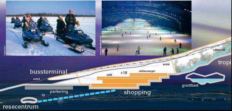
7 Cultural Heritage of buildings


8 Dependence on few but various types of industry and commerce Iron mine Space technology Tourism Reindeer herding
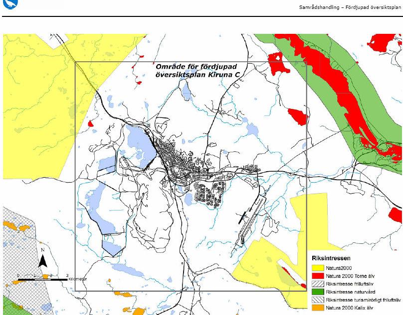
9 Nature- outdoor recreation-tourism


10 Mineral resourses national interest

11 Infrastructure Railway track, highway E10, airport

12 Reindeer herding National interest


13 Local authority comprehensive plan alternative directions of urban expansion

14 LKAB s proposal of urban development

15 LKAB s speculative vision
16 Planning and assessment activities Comprehensive plan for the town of Kiruna Railway plan Road plan Permit of extended ore mining Overarching and sector intergrating planning Sector planning Sector planning Sector planning
17 Actors Involved Kiruna local authority LKAB, iron mine company National Road Adm. National Railway Adm. National Airport Adm Stately Energy Company County Board
18 Stakeholders concerned Other authorities Inhabitants Commercial companies Tourism Sami people Space institute NGOs


19 Overlaping requirements on land-use
20 Conflicting interests and values Interacting with power relations
21 Intentions of an open democratic planning process Many parallell planning processes The actors have power over their type of sector process Challenges for the local authority comprehensive plan
22 Long-term planning under time pressure Iron company plans for 100 years ahead Comprehensive plan has vision of 25 year * The mine extension is related to the global iron prize The railway must be moved 1012
23 Uncertainties and risks Global iron price size of mine extension size of the new town Commuting convenience multi-functional region How to manage the complexity consisting of a manifold of uncertainties and risks
24 A Complex Planning Situation with a manifold and interconnected requirements and expectations
25 Various forms of planning perspectives Local authority comprehensive planning Road planning Muddling-through Communicative plan. Railway planning Technical rational plan. LKAB, iron company Negotiative planning
26 Hierarchy and power relations The local authority has power over land use by planning monopoly - Struggles with rules, laws and representative democracy The mining company has the economic power - Has possibilities of free and persuading visions The inhabitants trust both the local authority and the company
27 Strategic choices a more focused and more synoptic treatment of problem scope; a more simplifying and more elaborating treatment of complexity; a more reactive and a more interactive treatment of conflict; a more reducing and a more accommodating treatment of uncertainty; and a more exploratory and a more decisive treatment of progress through time. (Friend & Hickling 1997:1-25)
28 Governance and Institutions Formal institutions Most institutions keep there independence Limited partnerships
29 Actor Network Perspective Both heterogenic and homogenic actors are involved The formal institutions should act as homogenic actors The inhabitants are a heterogenic actor There are three main formal network levels A national network A regional network A local network
30 Complex and confused When the complexity is extremely high When the knowledge and uncertainties are too many There is a risk the planning organisations hang on and strengthen the formal hierarchies and rules
31 All actors are interconnected and dependent on each other Nevertheless they act for the specific sectors as they were independent
32 The complexity will stain with separate planning perspectives and The planning processes are in progress and the same with my observations and analysis

33
The Governance of Land Use
 The planning system Levels of government and their responsibilities The Governance of Land Use COUNTRY FACT SHEET NORWAY Norway is a unitary state with three levels of government; the national level, 19
The Governance of Land Use
 The Governance of Land Use Country fact sheet Austria The planning system Levels of government and their responsibilities Austria is a federal state with three levels of government; the national level,
Summary. Recommendations on the Fifth Policy Document on Spatial Planning September 2001
 Summary Recommendations on the Fifth Policy Document on Spatial Planning September 2001 2 Introduction In December 2000 the Dutch Cabinet issued Part 1 of the Fifth National Policy Document on Spatial
Community Engagement in Cultural Routes SiTI Higher Institute on Territorial Systems for Innovation Sara Levi Sacerdotti
 Transnational Workshop Wroclaw, 7th-8th December 2016 Community Engagement in Cultural Routes SiTI Higher Institute on Territorial Systems for Innovation Sara Levi Sacerdotti levi@siti.polito.it TAKING
The Role of Indigenous Cultures in Securing Sustainable Economic Development Of Mineral & Energy Resources: Australia & Sweden
 The Role of Indigenous Cultures in Securing Sustainable Economic Development Of Mineral & Energy Resources: Australia & Sweden Principal Research Leader Dr Boyd Blackwell UNE Business School, Australia
The Governance of Land Use
 The planning system The Governance of Land Use United Kingdom Levels of government and their responsibilities The United Kingdom is a unitary state with three devolved governments in Northern Ireland,
Legal problems of environmental management. Spatial planning and space management. M. Gajewski 2014 / 2015
 Legal problems of environmental management Spatial planning and space management M. Gajewski 2014 / 2015 Course contents (in brief) Constitutional basis of the environment protection system. General principles
Land Use in the context of sustainable, smart and inclusive growth
 Land Use in the context of sustainable, smart and inclusive growth François Salgé Ministry of sustainable development France facilitator EUROGI vice president AFIGéO board member 1 Introduction e-content+
The National Spatial Strategy
 Purpose of this Consultation Paper This paper seeks the views of a wide range of bodies, interests and members of the public on the issues which the National Spatial Strategy should address. These views
PURR: POTENTIAL OF RURAL REGIONS UK ESPON WORKSHOP Newcastle 23 rd November Neil Adams
 PURR: POTENTIAL OF RURAL REGIONS UK ESPON WORKSHOP Newcastle 23 rd November 2012 Neil Adams PURR: Potential of Rural Regions Introduction Context for the project A spectrum of knowledge Rural Potentials
16540/14 EE/cm 1 DG E 1A
 Council of the European Union Brussels, 5 December 2014 (OR. en) 16540/14 ENV 965 CULT 139 NOTE From: To: Subject: General Secretariat of the Council Delegations Charter of Rome on Natural and Cultural
2. Defining fisheries areas
 What does fisheries area mean in the context of the EFF? Axis 4 of the European Fisheries Fund (EFF) is different from the other three Axes in that it targets fisheries areas (it is titled Sustainable
The Governance of Land Use
 The planning system Levels of government and their responsibilities The Governance of Land Use Country fact sheet Germany Germany is a federal country with four levels of government. Below the national
State initiative following up the 2006 national planning report
 18 ness districts and public institutions, should be integrated with the opportunities for public transport services. State initiative following up the 2006 national planning report The Ministry of the
TOWARDS STRATEGIC SPATIAL PLANNING IN JAMAICA: THE NATIONAL SPATIAL PLAN
 TOWARDS STRATEGIC SPATIAL PLANNING IN JAMAICA: THE NATIONAL SPATIAL PLAN JIEP 5th Biennial Conference on the Environment: Balancing National Development and Environmental Protection June 6, 2011 Jamaica
A Method for Mapping Settlement Area Boundaries in the Greater Golden Horseshoe
 A Method for Mapping Settlement Area Boundaries in the Greater Golden Horseshoe Purpose This paper describes a method for mapping and measuring the lands designated for growth and urban expansion in the
Evaluation of Spatial Planning as a Tool for Integrated Marine Management Status, Obstacles and Research Gaps
 Evaluation of Spatial Planning as a Tool for Integrated Marine Management Status, Obstacles and Research Gaps Baltic MSP Forum Riga 17.-18. June 2014 A. Morf & A. Grimvall: Swedish Institute for the Marine
The Governance of Land Use
 The Governance of Land Use Country fact sheet Czech Republic The planning system Levels of government and their responsibilities The Czech Republic is a unitary state with 3 levels of government: the national
AMS E-GOS Local governance and performance of open data policies at municipal level
 AMS E-GOS Local governance and performance of open data policies at municipal level Frederika Welle Donker Knowledge Centre Open Data TU Delft f.m.welledonker@tudelft.nl 1 Knowledge Centre Open Data Research
The Governance of Land Use
 The Governance of Land Use COUNTRY FACT SHEET SPAIN The planning system Levels of government and their responsibilities Spain is defined by the OECD as a quasi-federal state with 4 levels of government;
The Governance of Land Use
 The Governance of Land Use Country fact sheet Poland The planning system Levels of government and their responsibilities Poland has 4 levels of government; the national government, 16 regional governments
National Land Use Policy and National Integrated Planning Framework for Land Resource Development
 Title National Land Use Policy and National Integrated Planning Framework for Land Resource Development Duration: 32 Weeks Objective: Adoption of appropriate land use planning approaches to: Maintain the
Declaration Population and culture
 Declaration Population and culture The ministers of the parties to the Alpine Convention regard the socio-economic and socio-cultural aspects mentioned in Article 2, Paragraph 2, Item a., as being central
CONFERENCE STATEMENT
 CONFERENCE STATEMENT We, the elected representatives from Canada, Denmark/Greenland, Finland, Iceland, Norway, Russia, Sweden and the United States of America; In collaboration with the indigenous peoples
How to measure Territorial Cohesion and Cooperation?
 How to measure territorial cohesion and cooperation? How to measure Territorial Cohesion and Cooperation? Brussels: 21 February Growth, Development or Cohesion? Economic Competitiveness Social Cohesion
Making maps: Traditions and perceptions in Europe. European spatial planning and cartographic representations
 ESPON Create Europe! Making maps: Traditions and perceptions in Europe Dr. Stefanie Dühr University of the West of England, Bristol, UK European spatial planning and cartographic representations Scenarios.
ESTIMATING THE SOCIAL & ENVIRONMENTAL EFFECTS OF ADVENTURE TOURISM AND RECREATION ON CROWN LAND IN BRITISH COLUMBIA
 ESTIMATING THE SOCIAL & ENVIRONMENTAL EFFECTS OF ADVENTURE TOURISM AND RECREATION ON CROWN LAND IN BRITISH COLUMBIA Wolfgang Haider School of Resource and Environmental Mgt. Simon Fraser University Burnaby,
The international patterns of spatial planning system and choice of China. Cai yumei China land use planning and surveying institute (China, beijing)
") FIG Working Week, Rome, Italy 6 10 May 2012 The international patterns of spatial system and choice of China Cai yumei China land use and surveying institute (China, beijing) Outline Background Problem
FIG Working Week, Rome, Italy 6 10 May 2012 The international patterns of spatial system and choice of China Cai yumei China land use and surveying institute (China, beijing) Outline Background Problem
Land Use Planning and Agriculture: Austrian Experiences and Challenges I
 Land Use Planning and Agriculture: Austrian Experiences and Challenges I SULANET Summer School 2016 Walter Seher BOKU Vienna 1 Land Use Planning and Agriculture 2 Land Use Planning and Agriculture Agriculture
Comprehensive Community Planning
 Comprehensive Community Planning Session Three: Preparing to Plan Part Two - Day 2 AM - Zoning and Land Use Decision Continued How does the Land Use Plan connect to the CCP? LUP direction included in /
Multi-level spatial planning in a cross border context
 Significant Experience No. 7 Multi-level spatial planning in a cross border context Brendan Murtagh School of Environmental Planning Queen s University Belfast 1. Context In many respects the essence of
Alps Results from the ESPON Project. Common spatial perspectives for the Alpine area. Towards a common vision
 Results from the ESPON Project Alps 2050 Common spatial perspectives for the Alpine area. Towards a common vision Tobias Chilla, University of Erlangen Cooperation Alps 2020+ 1 & 2 October 2018 Salzburg
Outline. Tourism A Viable Option for Abandoned Mines?
 Tourism A Viable Option for Abandoned Mines? Pete Whitbread-Abrutat Post-Mining Alliance, Eden Project Outline Post-Mining Alliance Mining and tourism Aspects of mining and tourism Case studies Success
Urbanization and Sustainable Development of Cities: A Ready Engine to Promote Economic Growth and Cooperation
 Urbanization and Sustainable Development of Cities: A Ready Engine to Promote Economic Growth and Cooperation Wan Portia Hamzah Institute of Strategic and International Studies (ISIS) Malaysia 10 September
CERTIFIED RESOLUTION. introduction: and dated May 29, 2017, as attached, as appropriate
 15322 Buena Vista Avenue, White Rock BC, Canada V4B 1Y6 www.whiterockcity.ca City of White Rock P: 604.541.22121 F: 604.541.9348 /2tC% City Clerk s Office IT E ROC K June 13,2017 Stephanie Lam, Deputy
Spatial Planning and Territorial Development at the Regional Level
 Spatial Planning and Territorial Development at the Regional Level Vincent Nadin University of the West of England, UK Spatial Planning and Territorial Development at the Regional Level Vincent Nadin University
Summary: This paper updates the Sub-committee on current thinking regarding the proposal for a Cotswolds Geopark
 REFRESH OF THE PROPOSAL FOR A COTSWOLDS GEOPARK Summary: This paper updates the Sub-committee on current thinking regarding the proposal for a Cotswolds Geopark Recommendations: a) That the Sub-committee
CAMP SLOVENIA. Mezek Slavko RRC Koper. Project coordinator November 2005
 CAMP SLOVENIA Mezek Slavko RRC Koper Project coordinator November 2005 http://camp.rrc-kp.si/ Content About MAP CAMP programme CAMP Slovenia Project background CAMP Slovenia Project area CAMP Slovenia
New governance mechanism for regional development in Europe. Willem Salet University of Amsterdam
 New governance mechanism for regional development in Europe Willem Salet University of Amsterdam Scheme of presentation Cities face rescaling of social and economic parameters Exploring new planning strategies
Governance in Metropolitan Regions in Germany
 Governance in Metropolitan Regions in Germany Tanja Blätter, Association of German Metropolitan Regions, Germany The European Committee on Democracy and Governance (CDDG) of the Council of Europe Thessaloniki,
Jordan's Strategic Research Agenda in cultural heritage
 Jordan's Strategic Research Agenda in cultural heritage Analysis of main results Alessandra Gandini Amman, Jordan 3 rd November 2013 Main objectives The work performed had the main objective of giving
Experiences of public-private partnerships in the Euromediterranean relations and in the Po Valley, promoting a more balanced European territory
 Experiences of public-private partnerships in the Euromediterranean relations and in the Po Valley, promoting a more balanced European territory Claudio Tolomelli PolyMetrexPlus project s objectives To
RURAL-URBAN PARTNERSHIPS: AN INTEGRATED APPROACH TO ECONOMIC DEVELOPMENT
 RURAL-URBAN PARTNERSHIPS: AN INTEGRATED APPROACH TO ECONOMIC DEVELOPMENT William Tompson Head of the Urban Development Programme OECD Public Governance and Territorial Development Directorate JAHRESTAGUNG
Arctic ecosystem services: TEEB Arctic Scoping study. Alexander Shestakov WWF Global Arctic Programme 3 December Arctic Biodiversity Congress
 Arctic ecosystem services: TEEB Arctic Scoping study Alexander Shestakov WWF Global Arctic Programme 3 December 20143 Arctic Biodiversity Congress Content 1. Project design 2. Approach 3. Challenges and
High speed network in Hauts-de-France Region. Värnamo, 17 th May 2018
 High speed network in Hauts-de-France Region Värnamo, 17 th May 2018 Hauts-de-France at the crossroads of the North-West Europe High speed train approach in France In the 1980s: will to link the main cities
The Swedish National Geodata Strategy and the Geodata Project
 The Swedish National Geodata Strategy and the Geodata Project Ewa Rannestig, Head of NSDI Co-ordination Unit, Lantmäteriet, ewa.rannstig@lm.se Ulf Sandgren, Project Manager Geodata Project, Lantmäteriet,
ENVIRONMENTAL CONSIDERATIONS IN CLUP
 ENVIRONMENTAL CONSIDERATIONS IN CLUP Ricardo M. Sandalo Assistant Professor DCERP, College of Human Ecology University of the Philippines Los Baños April 9-10, 2016 CHE Multi Purpose Hall 1 Twin Objectives
Overcoming Complexities on the Interface of Infrastructure and Land Use
 Date 22-11-2013 1 Overcoming Complexities on the Interface of Infrastructure and Land Use Towards design preconditions for integrated regional development Niels Heeres & Jos Arts University of Groningen,
CEMAT results - over the years
 CEMAT results - over the years Technical Conference on Functional Areas capitalization of local potential within the territorial development policies in Europe European Conference of Ministers responsible
Country Fiche Sweden Updated May 2018
 Country Fiche Sweden Updated May 2018 1. General information 2 the territorial sea (12-nm zone) 70,000 km2 the Exclusive Economic Zone 60,000 km2 the EEZ is limited to the central line between adjacent
Tourism. April State Planning Policy state interest guideline. Department of Infrastructure, Local Government and Planning
 Department of Infrastructure, Local Government and Planning State Planning Policy state interest guideline Tourism April 2016 Great state. Great opportunity. Preface Using this state interest guideline
SPATIAL STRATEGIES ON THE ISLAND OF IRELAND: FRAMEWORK FOR COLLABORATION
 SPATIAL STRATEGIES ON THE ISLAND OF IRELAND: FRAMEWORK FOR COLLABORATION THE PRACTICAL OPPORTUNITIES Mr. John Driscoll, Director, International Centre for Local and Regional Development Mr. Jim Hetherington,
DEPARTMENT OF GEOLOGY AND MINERAL INDUSTRIES WAYS & MEANS SUBCOMMITTEE ON NATURAL RESOURCES MARCH 2, 2017
 DEPARTMENT OF GEOLOGY AND MINERAL INDUSTRIES WAYS & MEANS SUBCOMMITTEE ON NATURAL RESOURCES MARCH 2, 2017 1 ABOUT DOGAMI AGENCY MISSION, VISION & GOALS 2 Lidar image of a stream network along the Umpqua
National planning report for Denmark
 National planning report for Denmark from the Minister for Environment and Energy Local identity and new challenges Summary 2000 1 CONTENTS 4 PREFACE: REGIONAL DEVELOPMENT AND SPATIAL PLANNING 6 1. BALANCED
COUNCIL OF THE EUROPEAN UNION. Brussels, 2 May /14 CULT 68
 COUNCIL OF THE EUROPEAN UNION Brussels, 2 May 2014 9129/14 CULT 68 NOTE from: General Secretariat of the Council to: Permanent Representatives Committee (Part 1) / Council No. prev. doc.: 8892/14 CULT
Introduction to the Gozo & Comino Local Plan
 Introduction to the Gozo & Comino Local Plan What is a Local Plan? A Local Plan is a land use document with written text (policies and justifications) and maps; Reconciles local needs with strategic considerations;
GEOGRAPHY QUESTION PAPER CODE 64/1/1. 4. Distinguish between towns and villages on the basis of occupation. 1
 GEOGRAPHY Time allowed : 3 hours Maximum Marks : 70 GENERAL INSTRUCTIONS : (i) (ii) There are 22 geneal questions. Question numbers 1-7 are very short answer questions carrying 1 mark each. Answer to these
The importance of visioning in urban strategic planning By Peter Robinson. MILE Master Class Urban Strategic Planning March 2016
 The importance of visioning in urban strategic planning By Peter Robinson MILE Master Class Urban Strategic Planning March 2016 Typical strategic planning process Where are we now? Where are we going?
A century of experience: Training and knowledge transfer in Africa 30 years of activities: Past, present and future
 Royal Museum for central Africa A century of experience:1898-2012 Training and knowledge transfer in Africa 30 years of activities: Past, present and future Earth Sciences Field Geology Geodynamics Major
OPINION. Results of EU Structural Policy in NSPA
 OPINION on the future European Cohesion Policy of the Northern Sparsely Populated Areas (NSPA) of Finland and Sweden with the contribution of North Norway The remote Northern Sparsely Populated Areas (NSPA)
TABLE OF CONTENTS ARTICLE I. POLK COUNTY COMPREHENSIVE PLAN VOLUME 1. Page CHAPTER 1. GENERAL... A-1
 TABLE OF CONTENTS ARTICLE I. POLK COUNTY COMPREHENSIVE PLAN VOLUME 1 Page CHAPTER 1. GENERAL... A-1 DIVISION 1.100 GENERAL PROVISIONS... A-1 DIVISION 1.200 BASIC PRINCIPLES... A-6 DIVISION 1.300 THE PLANNING
CLUDs for regenerating small historical centres
 Commercial Local Urban District project 7FP Marie Curie IRSES Open Days, Reggio Calabria - 4 and 5 July 2011 CLUDs for regenerating small historical centres Manuela RICCI Fo.Cu.S. Research Centre Sapienza
Storm Surge/Coastal Inundation State of the Union. Jamie Rhome Storm Surge Team Lead NOAA/National Hurricane Center
 Storm Surge/Coastal Inundation State of the Union Jamie Rhome Storm Surge Team Lead NOAA/National Hurricane Center 2 Tampa: Cat 5 Scenario 3 4 The Stakes are High Combination of SLR and increasing coastal
By Frikkie Brooks General Manager: Municipal Planning KwaZulu-Natal Department of Local Government and Traditional Affairs South Africa
 THE KWAZULU-NATAL SPATIAL ECONOMIC DEVELOPMENT STRATEGY (PSEDS): PROMOTING URBAN AND RURAL LINKAGES IN THE BEST INTEREST OF RURAL AND URBAN DEVELOPMENT By Frikkie Brooks General Manager: Municipal Planning
GIS, Maps and Spatial Analyses in Urban Planning
 GIS, Maps and Spatial Analyses in Urban Planning LOOM.02.331 ANTO AASA PhD, researcher Power of visualization: What s this? Economic spaces in Europe (chorems based approach) Europe economy 1646 General:
Norwegian spatial data infrastructure supporting disaster risk management Norwegian Mapping Authority
 Norwegian spatial data infrastructure supporting disaster risk management Norwegian Mapping Authority Arvid Lillethun, Norwegian Mapping Authority Land and Poverty 2018 Conference, World Bank 19.-23. March
Local EPM Implementation Process in 5 stages
 Local PM Implementation Process in 5 stages 3. Working groups 1. City nvironmental Profile/ Outlook 5. Consolidation & Institutionalisation 4. Strategy & Action plans 2. City Consultation Urban nvironmental
Enrico Bertacchini, Department of Economics - University of Torino
 The Role of Cultural Policy in Urban Regeneration The case of Torino Introduction Torino: Capital of Piedmont North-Western Italy 950.000 inhabitants A not very old picture After WWII Italian economic
HOTEL BUSINESS AND TOURISM INSTITUTE RUSSIAN SEGMENT OF THE SILK ROAD
 HOTEL BUSINESS AND TOURISM INSTITUTE RUSSIAN SEGMENT OF THE SILK ROAD RUDN university HOTEL BUSINESS AND TOURISM INSTITUTE (HBTI) RUDN (1960) HBTI (1997) 150 countries, 28000 students, 7100 international
Transnational SWOT Analysis
 Transnational SWOT Analysis THETRIS PROJECT WP3.4.1 PP6 - LAMORO Development Agency This project is implemented through the CENTRAL EUROPE Programme co-financed by the ERDF 1 Table of Contents Introduction:
Joint Planning Advisory Council July 19, 2011
 Joint Planning Advisory Council July 19, 2011 Global Cities Program Objectives Helping advance strategic thinking in a variety of critical areas. Facilitating informed decisionmaking on the part of public
EcoServ-GIS. EcoServ GIS Stage I. Why EcoServ GIS? 17/12/2012
 EcoServ-GIS Ecosystem Services Mapping: A Wildlife Trust GIS Toolkit to map ecosystem services at a county scale Dr Jonathan Winn Living Landscape Coordinator Durham Wildlife Trust Dr Chloe Bellamy Ecosystem
Spatial Planning in the Republic of Armenia
 Spatial Planning in the Republic of Armenia According to the Law of the Republic of Armenia on Urban Development, the main issues of the Republic s spatial development and actions for their solution are
Disaster Prevention and Management in Asia: The Context of Human Security and Its Relevance to Infrastructure Planning and Management
 Disaster Prevention and Management in Asia: The Context of Human Security and Its Relevance to Infrastructure Planning and Management Rajib Shaw http://www.iedm.ges.kyoto-u.ac.jp/ Contents Background and
The National Integrated Drought Information System in the Midwest
 The National Integrated Drought Information System in the Midwest Advancing Drought Science and Preparedness Across the Nation Ohio River Basin Alliance Summit Thomas More College October 19, 2018 What
Project for Formulation of Comprehensive Development Master Plan in the Mombasa Gate City in Republic of Kenya
 Project for Formulation of Comprehensive Development Master Plan in the Mombasa Gate City in Republic of Kenya WG: Land Use (Development Vision, Structure Plan) January 18, 2016 JICA Expert Team Working
Site Suitability Analysis for Local Airport Using Geographic Information System
 Cloud Publications International Journal of Advanced Remote Sensing and GIS 2018, Volume 7, Issue 1, pp. 2719-2727 ISSN 2320 0243, Crossref: 10.23953/cloud.ijarsg.368 Research Article Site Suitability
SPLAN-Natura Towards an integrated spatial planning approach for Natura th January, 2017 Brussels. Commissioned by DG Environment
 SPLAN-Natura 2000 Towards an integrated spatial planning approach for Natura 2000 Commissioned by DG Environment 17 th January, 2017 Brussels V. Simeonova (Ph.D.) Drivers towards integrating Biodiversity
UPTAKE AND PATHWAYS OF COASTAL ADAPTATION PROCESSES IN AUSTRALIA
 2015 Effect of Climate Change on the World's Oceans - Santos, Brazil UPTAKE AND PATHWAYS OF COASTAL ADAPTATION PROCESSES IN AUSTRALIA COASTAL COLLABORATION CLUSTER: MEETING COASTAL CHALLENGES Débora M.
38th UNWTO Affiliate Members Plenary Session Yerevan, Armenia, 4 October 2016
 38th UNWTO Affiliate Members Plenary Session Yerevan, Armenia, 4 October 2016 17:00-19:00 Open Debate 5: City Tourism Introduced and Moderated by Dr. Donald Hawkins George Washington University World urban
Cross-border Maritime Spatial Plan for the Black sea - Romania and Bulgaria project
 Cross-border Maritime Spatial Plan for the Black sea - Romania and Bulgaria project in Romania and Bulgaria Plan Presentation A first step in the management of the marine areas of Romania and Bulgaria
4D in City Transformations
 LICENTIATE T H E S I S 4D in City Transformations Systems, Processes and Actors Tim Johansson LICENTIATE THESIS 4D IN CITY TRANSFORMATIONS SYSTEMS, PROCESSES AND ACTORS Tim Johansson Luleå, November 2012
INTRODUCING THE EUROPEAN DIMENSION
 INTRODUCING THE EUROPEAN DIMENSION OF DANISH PLANNING ESPON/ENECON POSTGRADUATE WORKSHOP TERRITORIAL GOVERNANCE AND COOPERATION UNIVERSITY OF EASTERN FINLAND JOENSUU, FINLAND OCTOBER 19, 2012 DANIEL GALLAND
Significant Copper-Gold JORC Exploration Target
 12 March 2013 Highlights: ASX & MEDIA ANNOUNCEMENT Significant Copper-Gold JORC Exploration Target ü JORC i Exploration Target 1 of 4.8-6.2Mt @ 2.00-2.78% Cu and 1.23-2.23g/t Au confirmed. ü Opportunity
Environmental Management Information System (EMIS)
") United Nations Human Settlements Programme (UN-HABITAT) United Nations Environment Programme (UNEP) Environmental Management Information System (EMIS) a tool for Environmental Planning and Management (EPM)
United Nations Human Settlements Programme (UN-HABITAT) United Nations Environment Programme (UNEP) Environmental Management Information System (EMIS) a tool for Environmental Planning and Management (EPM)
Wayne E. Sirmon GEO 301 World Regional Geography
 Wayne E. Sirmon GEO 301 Geography 301 Geography 301 MAP: A graphic representation of a portion of the earth s surface dawn to scale, as seen from above. Types of Maps Climate maps give general information
Background and History
 p1 Background and History What is the Indian Ocean Climate Initiative? The Indian Ocean Climate Initiative (IOCI) is a strategic program of research and information transfer to support government decision-making.
Date: June 19, 2013 Meeting Date: July 5, Consideration of the City of Vancouver s Regional Context Statement
 Section E 1.5 To: From: Regional Planning and Agriculture Committee Lee-Ann Garnett, Senior Regional Planner Planning, Policy and Environment Department Date: June 19, 2013 Meeting Date: July 5, 2013 Subject:
The Use of Geographical Information Systems. in Historic and Cultural Places. Case Study: Town of Side. Omur ESEN
 The Use of Geographical Information Systems in Historic and Cultural Places Case Study: Town of Side Omur ESEN Selcuk University, Office of Construction and Infrastructure Dept. Konya,TURKEY omuresen@hotmail.com
The Contested Cultural Landscape of a Lebanese Border Town: MARJA AYOUN
 The Contested Cultural Landscape of a Lebanese Border Town: MARJA AYOUN IBD 2013 FNAS MAY 2013 Dr. Christine Mady, City & Regional Planning NDU -FAAD In this Presentation A PLANNING PERSPECTIVE INTRODUCING
Strengthening the cooperation in the region: Carpathian, Tisa,, Danube and Black Sea areas
 Strengthening the cooperation in the region: Carpathian, Tisa,, Danube and Black Sea areas 14th October 2009 SEE Annual Conference Advancing development through transnational cooperation in South East
CHAPTER 4 HIGH LEVEL SPATIAL DEVELOPMENT FRAMEWORK (SDF) Page 95
 Page 95") CHAPTER 4 HIGH LEVEL SPATIAL DEVELOPMENT FRAMEWORK (SDF) Page 95 CHAPTER 4 HIGH LEVEL SPATIAL DEVELOPMENT FRAMEWORK 4.1 INTRODUCTION This chapter provides a high level overview of George Municipality s
CHAPTER 4 HIGH LEVEL SPATIAL DEVELOPMENT FRAMEWORK (SDF) Page 95 CHAPTER 4 HIGH LEVEL SPATIAL DEVELOPMENT FRAMEWORK 4.1 INTRODUCTION This chapter provides a high level overview of George Municipality s
What is Spatial Planning?
 Spatial Planning in the context of the Responsible Governance of Tenure What is Spatial Planning? Text-only version This course is funded by the European Union through the EU-FAO Improved Global Governance
Decision-making support tool for promotion policies of abandoned mine areas
 2013 Esri International User Conference July 8 12, 2013 San Diego, California Decision-making support tool for promotion policies of abandoned mine areas Son, Jin Seoul National University Esri UC2013.
Proposed Scope of Work Village of Farmingdale Downtown Farmingdale BOA Step 2 BOA Nomination Study / Draft Generic Environmental Impact Statement
 Proposed Scope of Work Village of Farmingdale Downtown Farmingdale BOA Step 2 BOA Nomination Study / Draft Generic Environmental Impact Statement The scope of work that follows incorporates and covers
National Perspectives - Portugal. Margarida Almodovar
 National Perspectives - Portugal Margarida Almodovar margarida.almodovar@mam.gov.pt from base line to the external limit of the continental shelf behind 200 miles and according to UNCLOS definitions Economic
Department of Lands Planning and Housing. Development Plan of Mombasa City County
 Department of Lands Planning and Housing Development Plan of Mombasa City County Mombasa Gate City Profile Location and Linkages Located between the latitudes 3 80 and 4 10 S and longitudes 39 60 and 39
Chapter 1: Introduction to Safety and Ethics
 Core Curriculum Standards Met by Each Chapter On the Right Trail meets Utah s Social Studies Core Curriculum Standards for grades 3-7. Each chapter has specific standard objectives, which are met by the
UN-GGIM: Strengthening Geospatial Capability
 Fifth Plenary Meeting of UN-GGIM: Europe Brussels, 6-7 June 2018 UN-GGIM: Strengthening Geospatial Capability Walking the talk to leave no one behind Greg Scott, UN-GGIM Secretariat Environmental Statistics
CORPORATION OF THE CITY OF COURTENAY COUNCIL MEETING AGENDA
 CORPORATION OF THE CITY OF COURTENAY COUNCIL MEETING AGENDA DATE: Monday, January 14, 2013 PLACE: City Hall Council Chambers TIME: 4:00 p.m. 1.00 ADOPTION OF MINUTES 1. Adopt January 7, 2013 Regular Council