Introduction to the Gozo & Comino Local Plan
|
|
|
- Carol Shaw
- 6 years ago
- Views:
Transcription

1 Introduction to the Gozo & Comino Local Plan
 and maps; Reconciles local needs with strategic considerations; Identifies")
2 What is a Local Plan? A Local Plan is a land use document with written text (policies and justifications) and maps; Reconciles local needs with strategic considerations; Identifies opportunities for development and provides guidance and constraints for new development; Identifies also opportunities for social and environmental improvements;

3 The Local Plan s Vision is to increase employment opportunities on the Island whilst ensuring that the landscape character is not compromised. The Strategy The strategy for the Gozo & Comino local plan is based on the principles of sustainable development, that is, promoting development whilst ensuring that the natural and cultural capital of the islands is safeguarded for the enjoyment of current and future generations.
4

5 Aims To ensure that enough land is available for the future spatial development requirements. To continue to safeguard and enhance the unique cultural and natural characteristics that render Gozo and Comino so desirable to inhabit and visit. To encourage development which: creates economic development; Improves the quality of life and the environment; is compatible with planning policy; is compatible with surrounding activities; is efficient on land-use; does not constitute over-development; does not overload the road network and parking capacities; does not detract or endanger cultural or natural heritage; and does not negatively impact its surroundings.

6 Function of the Plan The local plan follows the Structure Plan, and indicates how principles, policies and standards will be applied to the local scale and guides development and other use of land. The Local Plan is an enabling plan which aims: - To safeguard environmental resources; - To provide a detailed basis for development control; - To provide a basis for promoting and coordinating appropriate Development;

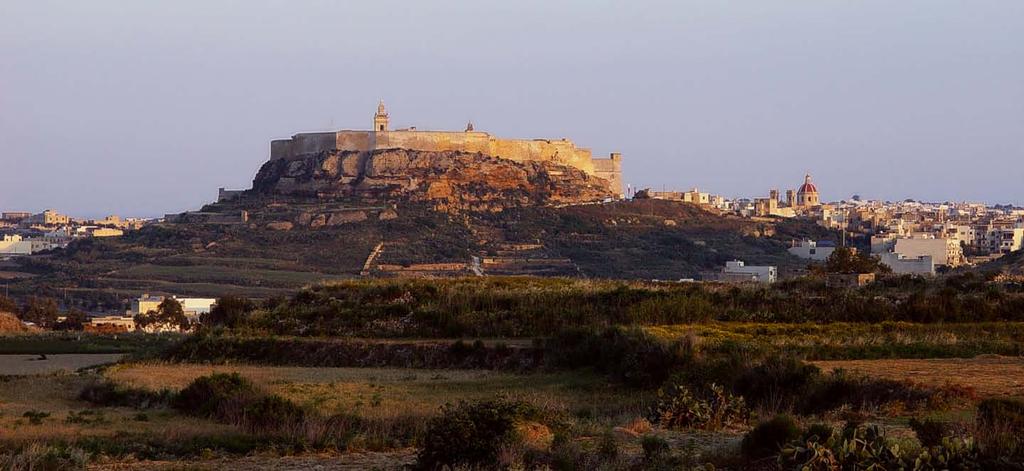
7 Policy Themes Settlement Policies Housing Transport Social & Community Facilities Utilities & Services Commerce & Industry Tourism & Recreation Agriculture Urban & Cultural Conservation Rural Conservation 14 Chapters of Area Policies

8 Inception Report The Local Plan draws on detail and strategic guidance provided through the Inception Report for the Gozo and Comino Local Plan. The Inception Report examined various topic areas relevant to the Local Plan, such as the Landscape Study.

9 The Landscape Assessment Study Main Goal : To analyse the visual components of the dynamic Maltese landscape and the most significant changes that occurred between with a view to formulate an integrated strategic planning policy.
10 Methodology Desk Studies Site Survey and Verification Comparative Analyses Identification of Landscape Character Areas Development of Landscape Assessment Model Designation and Policy

11 Maltese Landscape Character Low Hills Highly seasonal Sea visible from many areas Significant inland water bodies absent Strong lighting conditions Greenery very limited Limestone colours predominate Anthropological Influence omnipresent


12 Human Influence Long Presence High Population Density Intensive cultivation Urban Sprawl and infrastructural development Introduction of alien Species Increased mechanization and mobility Littering, dereliction, lack of attention to detail, lack of maintenance Pollution

13 Landscape Model Public Perception
14


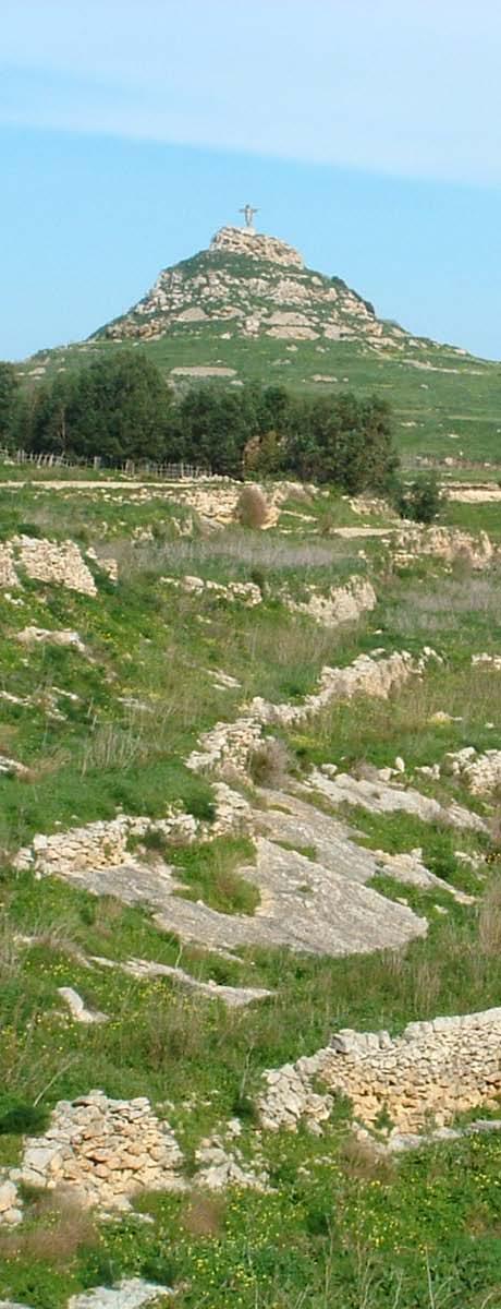
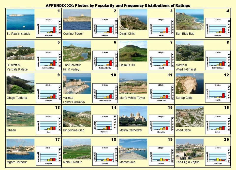
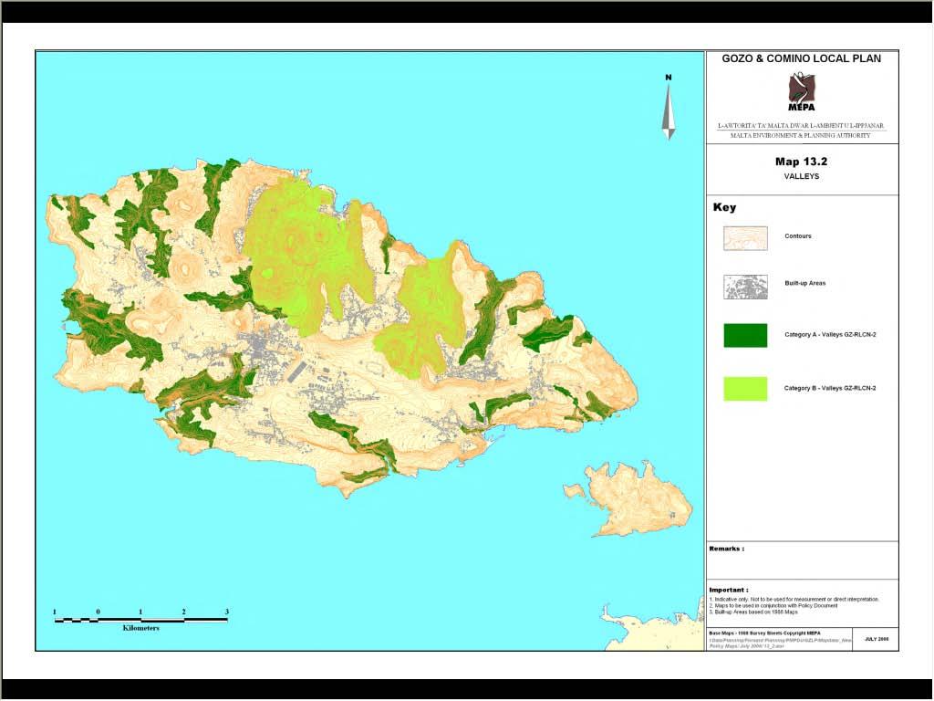
15 Comino Tower Landscape with steeper slopes and varied topography scored highly. The converse also applies. San Blas Beach Proximity to the coast confirmed as important. The highest scores were obtained for relatively un-spoilt coastal rural areas with sloping terrain Marsalforn Valley System Valleys received mostly high and very high scores, confirming the weighted attributed in the model algorithm Citadella Fortified Structures were generally accorded high or very high scores but this also depended on their proximity to detracting

16 LANDSCAPE MODEL RESULTS Landscape with steeper slopes and varied topography scored highly. The converse also applies Proximity to the coast confirmed as important. The highest scores were obtained for relatively un-spoilt coastal rural areas with sloping terrain and commanding extensive viewsheds Valleys received mostly high and very high scores, confirming the weighted attributed in the model algorithm Fortified Structures were generally accorded high or very high scores but this also depended on their proximity to detracting features Urban settlements were generally accorded a neutral value as the juxtaposition of enhancing and detracting features tended to cancel each other out Industrial areas, quarries and landfills in general received low scores although nearby scenery tended to elevate the score
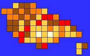
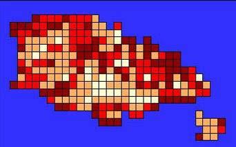
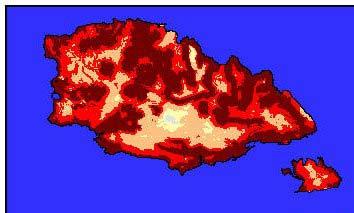

17 Landscape Sensitivity Model 1000m Grid 500m Grid 50m GRID
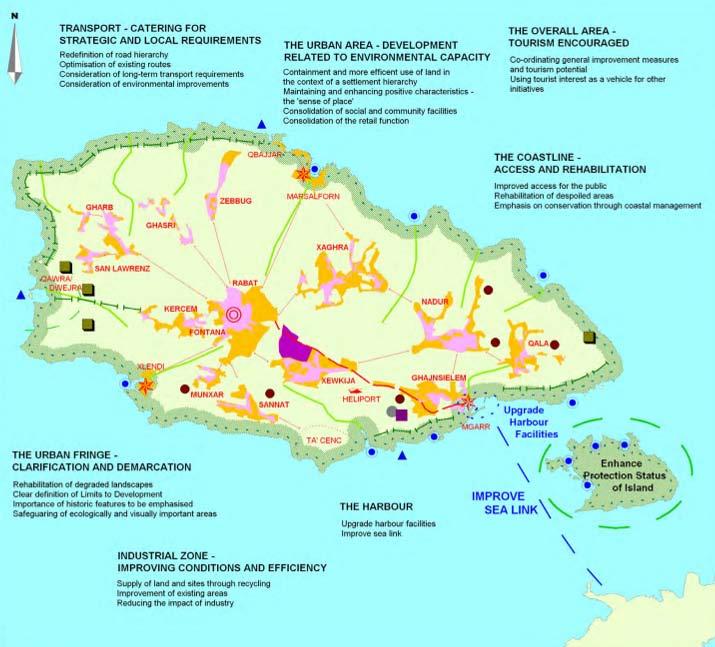
18 General Policy Maps
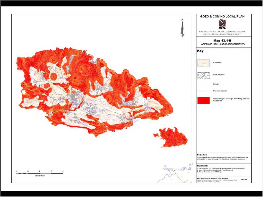
19
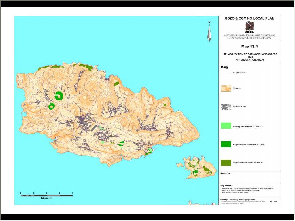
20
21
22
23
24 Area Policy Maps
25
26
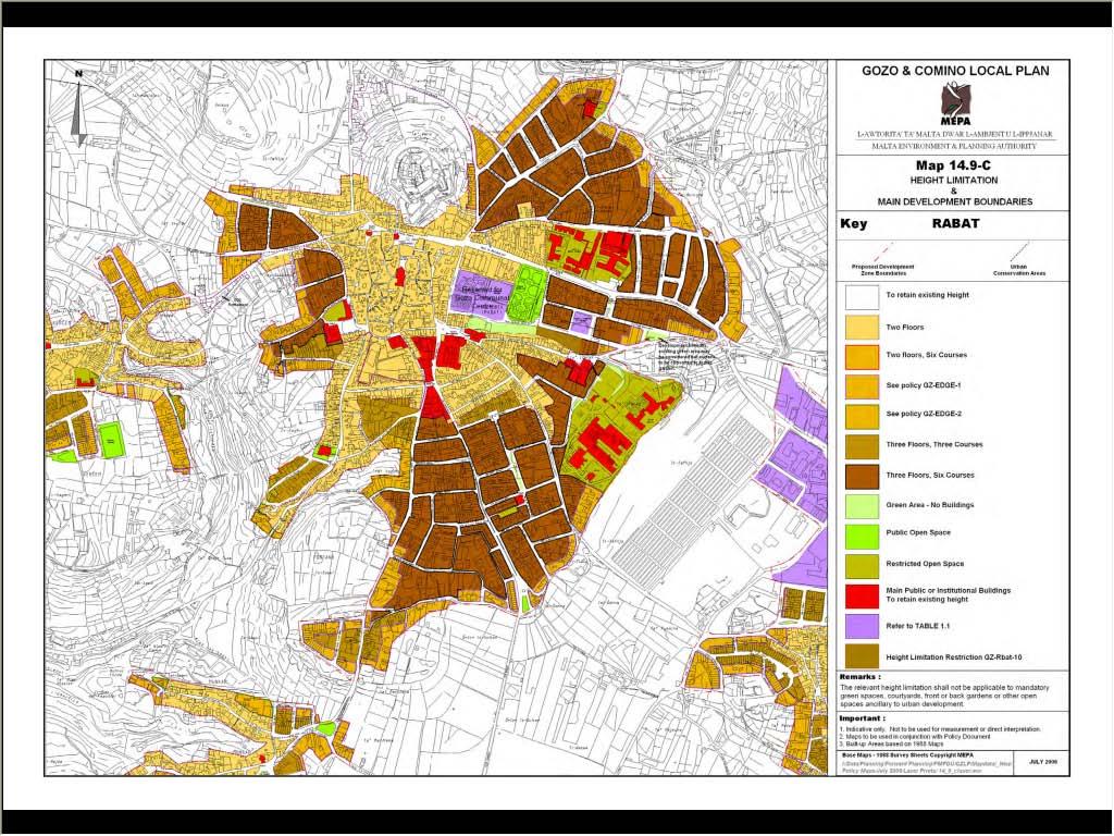
27
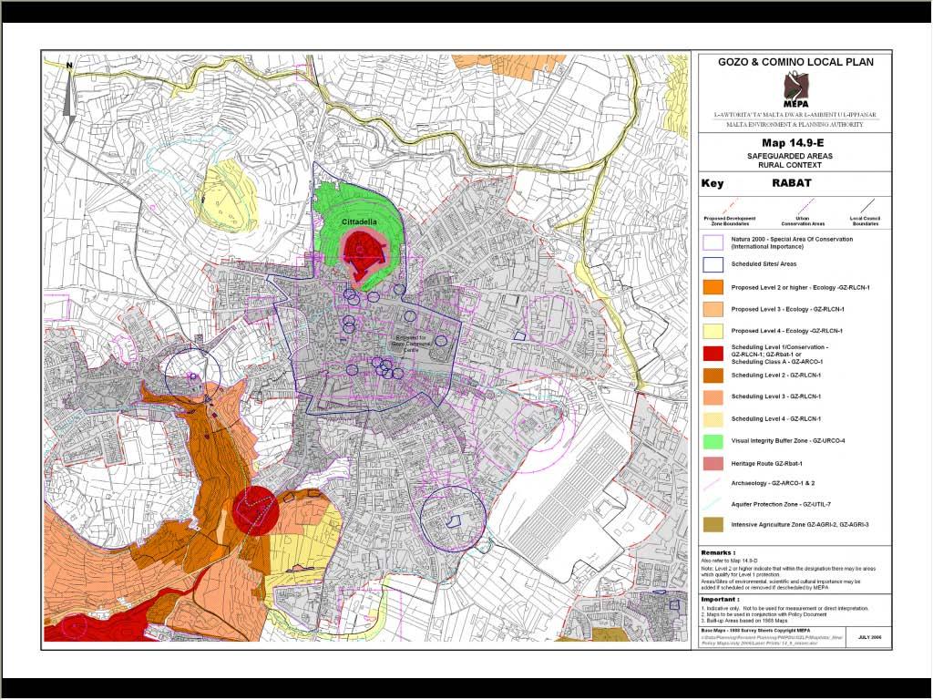
28
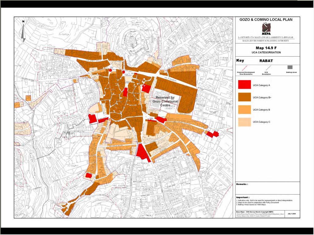
29
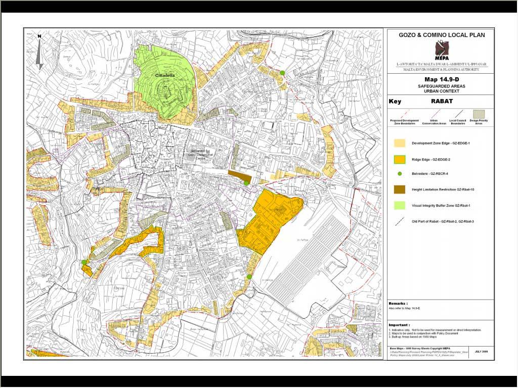
30
31 Thank you
Making maps: Traditions and perceptions in Europe. European spatial planning and cartographic representations
 ESPON Create Europe! Making maps: Traditions and perceptions in Europe Dr. Stefanie Dühr University of the West of England, Bristol, UK European spatial planning and cartographic representations Scenarios.
Local Area Key Issues Paper No. 13: Southern Hinterland townships growth opportunities
 Draft Sunshine Coast Planning Scheme Review of Submissions Local Area Key Issues Paper No. 13: Southern Hinterland townships growth opportunities Key Issue: Growth opportunities for Southern Hinterland
Tourism. April State Planning Policy state interest guideline. Department of Infrastructure, Local Government and Planning
 Department of Infrastructure, Local Government and Planning State Planning Policy state interest guideline Tourism April 2016 Great state. Great opportunity. Preface Using this state interest guideline
CHAPTER 4 HIGH LEVEL SPATIAL DEVELOPMENT FRAMEWORK (SDF) Page 95
 Page 95") CHAPTER 4 HIGH LEVEL SPATIAL DEVELOPMENT FRAMEWORK (SDF) Page 95 CHAPTER 4 HIGH LEVEL SPATIAL DEVELOPMENT FRAMEWORK 4.1 INTRODUCTION This chapter provides a high level overview of George Municipality s
CHAPTER 4 HIGH LEVEL SPATIAL DEVELOPMENT FRAMEWORK (SDF) Page 95 CHAPTER 4 HIGH LEVEL SPATIAL DEVELOPMENT FRAMEWORK 4.1 INTRODUCTION This chapter provides a high level overview of George Municipality s
The National Spatial Strategy
 Purpose of this Consultation Paper This paper seeks the views of a wide range of bodies, interests and members of the public on the issues which the National Spatial Strategy should address. These views
16540/14 EE/cm 1 DG E 1A
 Council of the European Union Brussels, 5 December 2014 (OR. en) 16540/14 ENV 965 CULT 139 NOTE From: To: Subject: General Secretariat of the Council Delegations Charter of Rome on Natural and Cultural
Measuring Disaster Risk for Urban areas in Asia-Pacific
 Measuring Disaster Risk for Urban areas in Asia-Pacific Acknowledgement: Trevor Clifford, Intl Consultant 1 SDG 11 Make cities and human settlements inclusive, safe, resilient and sustainable 11.1: By
State initiative following up the 2006 national planning report
 18 ness districts and public institutions, should be integrated with the opportunities for public transport services. State initiative following up the 2006 national planning report The Ministry of the
Coastal Environment. Introduction. 4.1 Coastal Environment. Extent of Coastal Environment
 4 The primary objective (set out in Chapter 2) to be implemented by this Chapter is Objective 2.4 ; the following objectives are also relevant due to the objectives integrated nature: 2.1 Tāngata whenua
TOWARDS STRATEGIC SPATIAL PLANNING IN JAMAICA: THE NATIONAL SPATIAL PLAN
 TOWARDS STRATEGIC SPATIAL PLANNING IN JAMAICA: THE NATIONAL SPATIAL PLAN JIEP 5th Biennial Conference on the Environment: Balancing National Development and Environmental Protection June 6, 2011 Jamaica
CLAREMONT MASTER PLAN 2017: LAND USE COMMUNITY INPUT
 Planning and Development Department 14 North Street Claremont, New Hampshire 03743 Ph: (603) 542-7008 Fax: (603) 542-7033 Email: cityplanner@claremontnh.com www.claremontnh.com CLAREMONT MASTER PLAN 2017:
The Contested Cultural Landscape of a Lebanese Border Town: MARJA AYOUN
 The Contested Cultural Landscape of a Lebanese Border Town: MARJA AYOUN IBD 2013 FNAS MAY 2013 Dr. Christine Mady, City & Regional Planning NDU -FAAD In this Presentation A PLANNING PERSPECTIVE INTRODUCING
Measurement of the Urban-Housing Deficit:
 Measurement of the Urban-Housing Deficit: Strategies, tools and sources of information The International Network for Urban and Regional Statistics Standing Committee of the International Association for
20/04/2011. Qantas Domestic Terminal Sydney. Urban Design_Shanghai Bund. Fox Studio, Sydney. Millennium Parklands, Homebush, Sydney
 09 November 2010 Founded in Australia in 1938, HASSELL is a single, privately owned international network of design studios. Designing the Built Environment with Spatial Technologies_ the HASSELL Experience
Al Ain Cultural Heritage Management Strategy 1/102
 AL AIN CULTURAL HERITAGE MANAGEMENT STRATEGY EXECUTIVE SUMMARY The cultural heritage of Al Ain is rich and varied; it consists of tangible and intangible resources and incorporates archaeological sites,
Urbanization and Sustainable Development of Cities: A Ready Engine to Promote Economic Growth and Cooperation
 Urbanization and Sustainable Development of Cities: A Ready Engine to Promote Economic Growth and Cooperation Wan Portia Hamzah Institute of Strategic and International Studies (ISIS) Malaysia 10 September
Local Development Pilot Project: Island of Cres. Ranka Saračević Würth, Ministry of Culture, Republic of Croatia
 Local Development Pilot Project: Island of Cres Ranka Saračević Würth, Ministry of Culture, Republic of Croatia BACKGROUND, RATIFICATION OF THE FARO CONVENTION BY REPUBLIC OF CROATIA The Framework Convention
Navigable maritime and river waterways in the seaside - Danube Delta area and the connected rural development
 SUMMARY OF Ph-D Thesis, with title RESEARCH STUDIES ON MANAGEMENT IMPROVEMENT OF MARITIME AND RIVER TRANSPORT ACTIVITY IN THE COASTAL AND DANUBE DELTA AREA FROM AN ENVIROMENTAL, ECONOMIC AND SOCIAL PERSPECTIVE
CORPORATION OF THE CITY OF COURTENAY COUNCIL MEETING AGENDA
 CORPORATION OF THE CITY OF COURTENAY COUNCIL MEETING AGENDA DATE: Monday, January 14, 2013 PLACE: City Hall Council Chambers TIME: 4:00 p.m. 1.00 ADOPTION OF MINUTES 1. Adopt January 7, 2013 Regular Council
Key issues of regional development: DIAMONT WP6 experience. Vincent Briquel, Cemagref, France
 Key issues of regional development: DIAMONT WP6 experience Vincent Briquel, Cemagref, France WP6 objectives DIAMONT: provide with a basis for monitoring the sustainability of regional development in the
Introduction and Project Overview
 Greater New Orleans Regional Land Use Modeling GIS Techniques in a P olitical C ontext Louisiana Remote Sensing and GIS Workshop Wednesday, April 24, 2013 Working Towards a Shared Regional Vision Introduction
Key Indicators for Territorial Cohesion & Spatial Planning Stakeholder Workshop - Project Update. 13 th December 2012 San Sebastián, Basque Country
 Key Indicators for Territorial Cohesion & Spatial Planning Stakeholder Workshop - Project Update 13 th December 2012 San Sebastián, Basque Country Key Aims Explore the use of territorial data in developing
ALTER ECO Alternative tourist strategies to enhance the local sustainable development of tourism by promoting Mediterranean identity Module 2: Testing
 ALTER ECO Alternative tourist strategies to enhance the local sustainable development of tourism by promoting Mediterranean identity Module 2: Testing WHY? Areas of high tourism attraction in coastal cities
Declaration Population and culture
 Declaration Population and culture The ministers of the parties to the Alpine Convention regard the socio-economic and socio-cultural aspects mentioned in Article 2, Paragraph 2, Item a., as being central
CLLD Cooperation OFFER
 Title of the proposed project (English) CLLD Cooperation OFFER PARKS PROTECTION III - Management, Protection and Economic Development in Protected Areas Type of project (select as many as you want) Cooperation
THE ROLE OF REGIONAL SPATIAL PLANNING IN SUPPORTING LONG-TERM ECONOMIC GROWTH IN NORTHERN IRELAND
 THE ROLE OF REGIONAL SPATIAL PLANNING IN SUPPORTING LONG-TERM ECONOMIC GROWTH IN NORTHERN IRELAND Jenny Pyper Director 6 th Annual ICLRD Conference 20 January 2011 PURPOSE OF REGIONAL PLANNING Framework
1. Demand for property on the coast
 1. Demand for property on the coast Key message Irrespective of density and location, population in Europe in general tends to concentrate in coastal areas. Detailed spatial elaboration of processes shows
Heritage and Cultural Tourism Management
 Unit 34: Heritage and Cultural Tourism Management Unit code: L/601/1757 QCF level: 4 Credit value: 15 Aim The aim of this unit is to enable learners to gain understanding of the heritage and cultural,
DETERMINE OF REGIONAL DEVELOPMENT STRATEGIES IN IZMIR
 Sukran Yalpir Asli Bozdag Saban Inam DETERMINE OF REGIONAL DEVELOPMENT STRATEGIES IN IZMIR Globalization INTRODUCTION Economic pressure cause Economic migration cause cause Spatial organizations Spatial
Proposed Scope of Work Village of Farmingdale Downtown Farmingdale BOA Step 2 BOA Nomination Study / Draft Generic Environmental Impact Statement
 Proposed Scope of Work Village of Farmingdale Downtown Farmingdale BOA Step 2 BOA Nomination Study / Draft Generic Environmental Impact Statement The scope of work that follows incorporates and covers
Entrepreneurship on islands and other peripheral regions. Specific Contract No 6511 implementing Framework contract No CDR/DE/16/2015/
 Entrepreneurship on islands and other peripheral regions Specific Contract No 6511 implementing Framework contract No CDR/DE/16/2015/ Aims of this study: To analyse the particular challenges and obstacles
From individual perceptions and statistical data to instruments for land resource management
 From individual s and statistical data to instruments for land Land Ulrike Tappeiner, Innsbruck / Bolzano Status quo versus Stefan Marzelli, München Instruments Status quo versus The two sides of the same
It is clearly necessary to introduce some of the difficulties of defining rural and
 UNIT 2 CHANGING HUMAN ENVIRONMENTS G2 Theme 2 Investigating Settlement Change in MEDCs 2.1 What are the distinctive features of settlements? It is clearly necessary to introduce some of the difficulties
Tackling urban sprawl: towards a compact model of cities? David Ludlow University of the West of England (UWE) 19 June 2014
 19 June 2014") Tackling urban sprawl: towards a compact model of cities? David Ludlow University of the West of England (UWE) 19 June 2014 Impacts on Natural & Protected Areas why sprawl matters? Sprawl creates environmental,
Tackling urban sprawl: towards a compact model of cities? David Ludlow University of the West of England (UWE) 19 June 2014 Impacts on Natural & Protected Areas why sprawl matters? Sprawl creates environmental,
Regional Plan 4: Integrating Ecosystem Services Mapping into Regional Land Use Planning
 Rural-Urban Outlooks: Unlocking Synergies (ROBUST) ROBUST receives funding from the European Union s Horizon 2020 research and innovation programme under grant agreement No 727988.* October 2018 Natural
Faatasi Malologa (PGSC Chair) Director Department of Lands & Survey, Tuvalu
 Director Department of Lands & Survey, Tuvalu") Seventh Session of the United Nations Committee of Experts on Global Geospatial Information Management (UN-GGIM) - 31 July -4 August 2017 Faatasi Malologa (PGSC Chair) Director Department of Lands & Survey,
Seventh Session of the United Nations Committee of Experts on Global Geospatial Information Management (UN-GGIM) - 31 July -4 August 2017 Faatasi Malologa (PGSC Chair) Director Department of Lands & Survey,
Building the Sustainable Network of Settlements on the Caspian Sea Region of Kazakhstan
 Building the Sustainable Network of Settlements on the Caspian Sea Region of Kazakhstan Introduction The Ecological Zoning and Identification of Ecological Capacity of Natural and Socio- Economic Potential
Interregional Cooperation in the Apennines
 INTERNATIONAL WORKSHOP THE ALPS AND THE ARDENNES: SHARING EXPERIENCES AMONG TRANSBOUNDARY MOUNTAIN AREAS Interregional Cooperation in the Apennines Massimo Sargolini, professor at the University of Camerino,
Towards a City Model for Heritage-Led Regeneration and Tourism Development
 Towards a City Model for Heritage-Led Regeneration and Tourism Development Brian Smith, Secretary General European Association of Historic Towns and Regions Summary of Presentation Objective Background
Northland Regional Landscape Assessment Worksheet
 Northland Regional Landscape Assessment Worksheet Unit name HURUPAKI VOLCANIC CONE DESCRIPTION AND CHARACTERISATION Component Land Types Volcanic cones land type Comment One of a sequence of volcanic cones,
Cultural Routes of the Council of Europe - Glossary
 Cultural Routes of the Council of Europe - Glossary Below is a collection of terms linked to Cultural Routes of the Council of Europe. The glossary is taken from the book Cultural Routes management: from
Spatial analysis of locational conflicts
 Spatial analysis of locational conflicts Case study: Locational conflicts generated by the expansion of built up surfaces in the northern area of Bucharest, Romania Diana A. ONOSE 1, Cristian I. IOJĂ 2,
Dr.Sinisa Vukicevic Dr. Robert Summers
 Dr.Sinisa Vukicevic Dr. Robert Summers "Planning" means the scientific, aesthetic, and orderly disposition of land, resources, facilities and services with a view to securing the physical, economic and
European Maritime Day conference 21 May Hon Karmenu Vella, Minister for Tourism welcome speech
 European Maritime Day conference 21 May 2013 Hon Karmenu Vella, Minister for Tourism welcome speech Commissioner Damanaki, Ministers, Distinguished speakers, Ladies and Gentlemen On behalf of Malta, I
European Landscape Convention in the Slovak Republic
 13th COUNCIL OF EUROPE MEETING OF THE WORKSHOPS FOR THE EUROPEAN LANDSCAPE CONVENTION European Landscape Convention in the Slovak Republic Mrs. Ida Vanáková, state advisor, Department of Spatial Planning
Size matters: issues and challenges of local development with a special focus on small and medium sized towns in Czechia
 Size matters: issues and challenges of local development with a special focus on small and medium sized towns in Czechia Luděk Sýkora Charles University, Faculty of Science Dept. of Social Geography and
Seaton to Seaton Hole SUMMARY OF PREFERRED PLAN RECOMMENDATIONS AND JUSTIFICATION
 Location reference: Policy Unit reference: Plan: Seaton to Seaton Hole 6a29 and 6a30 SUMMARY OF PREFERRED PLAN RECOMMENDATIONS AND JUSTIFICATION The large number of properties and assets at risk in the
INDIANA ACADEMIC STANDARDS FOR SOCIAL STUDIES, WORLD GEOGRAPHY. PAGE(S) WHERE TAUGHT (If submission is not a book, cite appropriate location(s))
 WHERE TAUGHT (If submission is not a book, cite appropriate location(s))") Prentice Hall: The Cultural Landscape, An Introduction to Human Geography 2002 Indiana Academic Standards for Social Studies, World Geography (Grades 9-12) STANDARD 1: THE WORLD IN SPATIAL TERMS Students
Prentice Hall: The Cultural Landscape, An Introduction to Human Geography 2002 Indiana Academic Standards for Social Studies, World Geography (Grades 9-12) STANDARD 1: THE WORLD IN SPATIAL TERMS Students
PURR: POTENTIAL OF RURAL REGIONS UK ESPON WORKSHOP Newcastle 23 rd November Neil Adams
 PURR: POTENTIAL OF RURAL REGIONS UK ESPON WORKSHOP Newcastle 23 rd November 2012 Neil Adams PURR: Potential of Rural Regions Introduction Context for the project A spectrum of knowledge Rural Potentials
9. Parashant Dark Sky Park Light Management Plan (LMP)
") 9. Parashant Dark Sky Park Light Management Plan (LMP) Introduction: Grand Canyon-Parashant National Monument encompasses over a million acres, including joint federal agencies, Arizona state lands, and
9. Parashant Dark Sky Park Light Management Plan (LMP) Introduction: Grand Canyon-Parashant National Monument encompasses over a million acres, including joint federal agencies, Arizona state lands, and
PACIFIC ISLANDS REGIONAL OCEAN POLICY. A healthy Ocean that sustains the livelihoods and aspirations of Pacific Island communities.
 PACIFIC ISLANDS REGIONAL OCEAN POLICY VISION A healthy Ocean that sustains the livelihoods and aspirations of Pacific Island communities. THIS IS OUR OCEAN 1. The care of the ocean is the responsibility
CAMP SLOVENIA. Mezek Slavko RRC Koper. Project coordinator November 2005
 CAMP SLOVENIA Mezek Slavko RRC Koper Project coordinator November 2005 http://camp.rrc-kp.si/ Content About MAP CAMP programme CAMP Slovenia Project background CAMP Slovenia Project area CAMP Slovenia
Developing urban ecosystem accounts for Great Britain. Emily Connors Head of Natural Capital Accounting Office for National Statistics (UK)
") Developing urban ecosystem accounts for Great Britain Emily Connors Head of Natural Capital Accounting Office for National Statistics (UK) UN 2014 UN 2014 ONS 2017 UK motivation 54% 82% 5,900 Of the world
Developing urban ecosystem accounts for Great Britain Emily Connors Head of Natural Capital Accounting Office for National Statistics (UK) UN 2014 UN 2014 ONS 2017 UK motivation 54% 82% 5,900 Of the world
This table connects the content provided by Education Perfect to the NSW Syllabus.
 Education Perfect Geography provides teachers with a wide range of quality, engaging and innovative content to drive positive student learning outcomes. Designed by teachers and written by our in-house
COUNCIL OF THE EUROPEAN UNION. Brussels, 2 May /14 CULT 68
 COUNCIL OF THE EUROPEAN UNION Brussels, 2 May 2014 9129/14 CULT 68 NOTE from: General Secretariat of the Council to: Permanent Representatives Committee (Part 1) / Council No. prev. doc.: 8892/14 CULT
PROTOCOL ON THE IMPLEMENTATION OF THE ALPINE CONVENTION OF 1991 RELATING TO SPATIAL PLANNING AND SUSTAINABLE DEVELOPMENT
 PROTOCOL ON THE IMPLEMENTATION OF THE ALPINE CONVENTION OF 1991 RELATING TO SPATIAL PLANNING AND SUSTAINABLE DEVELOPMENT SPATIAL PLANNING AND SUSTAINABLE DEVELOPMENT" PROTOCOL Preamble The Republic of
City and SUMP of Ravenna
 City and SUMP of Ravenna Nicola Scanferla Head of Mobility Planning Unit, Municipality of Ravenna nscanferla@comune.ra.it place your logo here 19 April, 2017 1st Steering Committee Meeting, Nicosia, Cyprus
National Land Use Policy and National Integrated Planning Framework for Land Resource Development
 Title National Land Use Policy and National Integrated Planning Framework for Land Resource Development Duration: 32 Weeks Objective: Adoption of appropriate land use planning approaches to: Maintain the
Rural Gentrification: Middle Class Migration from Urban to Rural Areas. Sevinç Bahar YENIGÜL
 'New Ideas and New Generations of Regional Policy in Eastern Europe' International Conference 7-8 th of April 2016, Pecs, Hungary Rural Gentrification: Middle Class Migration from Urban to Rural Areas
City of Chino Hills General Plan Update 13GPA02 Scoping Meeting. June 4, 2013
 13GPA02 Scoping Meeting June 4, 2013 Every California city must adopt a comprehensive, long-term general plan. The General Plan is the City s constitution or blueprint for its long-range physical development.
Possibilities for applying ES assessment results in spatial planning in Latvia
 Possibilities for applying ES assessment results in spatial planning in Latvia Inga Hoņavko LIFE EcosystemServices project manager LIFE Viva Grass seminar, Sigulda, 17.05.2018 Projekts LIFE EcosystemServices,
MEADOWS PRIMARY SCHOOL and NURSERY GEOGRAPHY POLICY
 MEADOWS PRIMARY SCHOOL and NURSERY GEOGRAPHY POLICY Purpose of study The teaching of Geography at Meadows is done by following the 2014 National Curriculum. The planning and teaching of the subject aims
The Governance of Land Use
 The planning system Levels of government and their responsibilities The Governance of Land Use COUNTRY FACT SHEET NORWAY Norway is a unitary state with three levels of government; the national level, 19
GEOGRAPHY POLICY STATEMENT. The study of geography helps our pupils to make sense of the world around them.
 GEOGRAPHY POLICY STATEMENT We believe that the study of geography is concerned with people, place, space and the environment and explores the relationships between the earth and its peoples. The study
The importance of visioning in urban strategic planning By Peter Robinson. MILE Master Class Urban Strategic Planning March 2016
 The importance of visioning in urban strategic planning By Peter Robinson MILE Master Class Urban Strategic Planning March 2016 Typical strategic planning process Where are we now? Where are we going?
Regional Snapshot Series: Transportation and Transit. Commuting and Places of Work in the Fraser Valley Regional District
 Regional Snapshot Series: Transportation and Transit Commuting and Places of Work in the Fraser Valley Regional District TABLE OF CONTENTS Complete Communities Daily Trips Live/Work Ratio Commuting Local
APPENDIX I - AREA PLANS
 ROUTE 37 WEST LAND USE PLAN ROUTE 37 WEST LAND USE PLAN Recent land use decisions and development trends have drawn attention to the land within the Route 37 western by-pass area between Route 50 and
GIS Technology and Tools for Long Range Transportation Planning in the National Park Service
 GIS Technology and Tools for Long Range Transportation Planning in the National Park Service Geospatial Information Systems for Transportation Symposium Loveland, Colorado April 16, 2012 Nell Blodgett
The European territory: Strategic developmentd
 The European territory: Strategic developmentd Peter Mehlbye Workshop Strategic Development Catalonia 11 June 2002 THE LECTURE Structure I. Territorial trends II. Strategy for European spatial development
2 nd Semester. Core Courses. C 2.1 City and Metropolitan Planning. Module 1: Urban Structure and Growth Implications
 2 nd Semester Core Courses C 2.1 City and Metropolitan Planning Module 1: Urban Structure and Growth Implications Growth of cities; cities as engine of growth; urban sprawl; land value, economic attributes
Site Suitability Analysis for Local Airport Using Geographic Information System
 Cloud Publications International Journal of Advanced Remote Sensing and GIS 2018, Volume 7, Issue 1, pp. 2719-2727 ISSN 2320 0243, Crossref: 10.23953/cloud.ijarsg.368 Research Article Site Suitability
Regional Growth Strategy Regional Staff Committee
 Regional Growth Strategy Regional Staff Committee June 21, 2018 1 Overview Summary of June Growth Management Policy Board Regional Growth Strategy Objectives Regional Geographies Regional Growth Strategy
iv vi x Using maps 2 Using images and analysing data 6 Using new technologies in geography 8
 Contents Exam board specification map Introduction Topic checker iv vi x Geographical skills Using maps 2 Using images and analysing data 6 Using new technologies in geography 8 Natural hazards Tectonic
Together towards a Sustainable Urban Agenda
 Together towards a Sustainable Urban Agenda The City We (Youth) Want Preliminary findings from youth consultations Areas Issue Papers Policy Units 1.Social Cohesion and Equity - Livable Cities 2.Urban
Geographical knowledge and understanding scope and sequence: Foundation to Year 10
 Geographical knowledge and understanding scope and sequence: Foundation to Year 10 Foundation Year 1 Year 2 Year 3 Year 4 Year 5 Year 6 Year level focus People live in places Places have distinctive features
MAP. Contours: Walk before you run! Four figure grid reference: e.g. Dot is at Six figure grid reference: e.g.
 MAP Page 2 Walk before you run! Four figure grid reference: e.g. Dot is at 4665 Six figure grid reference: e.g. Dot is at 463654 Compass points for direction Contours: Measure from sea level in meters
Outline. Tourism A Viable Option for Abandoned Mines?
 Tourism A Viable Option for Abandoned Mines? Pete Whitbread-Abrutat Post-Mining Alliance, Eden Project Outline Post-Mining Alliance Mining and tourism Aspects of mining and tourism Case studies Success
Edexcel GCSE Geography A
 Edexcel GCSE Comparing the 2012 AQA GCSE specification with the new 2016 Edexcel specification This document is designed to help you compare the existing 2012 AQA GCSE specification (9030) with the new
Overview of proposed approach to the Desktop Study to inform discussion
 LTAS Phase 2: Climate Change Implications for the Human Settlements sector in South Africa Overview of proposed approach to the Desktop Study to inform discussion Project Team Project Lead: Crispian Olver
Regional Growth Strategy Work Session Growth Management Policy Board
 Regional Growth Strategy Work Session Growth Management Policy Board September 6, 2018 1 Overview Recap June GMPB work session Objectives and outcomes Regional geographies Growth scenarios Breakout Discussion:
Legal problems of environmental management. Spatial planning and space management. M. Gajewski 2014 / 2015
 Legal problems of environmental management Spatial planning and space management M. Gajewski 2014 / 2015 Course contents (in brief) Constitutional basis of the environment protection system. General principles
AP Human Geography Free Response Questions Categorized
 AP Human Geography Free Response Questions Categorized 2002-2010 2. Population (13-17%) 3. Over the past 150 years, Europe has changed from a source to a destination region for international migration.
Work Group A «Core Data» Report and Update François Chirié, Dominique Laurent, France
 JOINT UN-GGIM: EUROPE ESS MEETING ON THE INTEGRATION OF STATISTICAL AND GEOSPATIAL INFORMATION LUXEMBOURG 11 MARCH 2016 Work Group A «Core Data» Report and Update François Chirié, Dominique Laurent, France
Integration for Informed Decision Making
 Geospatial and Statistics Policy Intervention: Integration for Informed Decision Making Greg Scott Global Geospatial Information Management United Nations Statistics Division Department of Economic and
GIS and territorial planning
 icccbe 2010 Nottingham University Press Proceedings of the International Conference on Computing in Civil and Building Engineering W Tizani (Editor) GIS and territorial planning S. Sheina & V. Shumeev
NATURE AND EXTENT OF PROPOSED DEVELOPMENT. Amount of Development Development Zones Distribution of Density Policies
 NATURE AND EXTENT OF PROPOSED DEVELOPMENT Amount of Development Development Zones Distribution of Density Policies DRAFT POOLBEG PLANNING SCHEME Amount of Development 78 4.1 The rationale for the overall
Economic Activity Economic A ctivity
 5 Economic Economic Activity Activity ECONOMIC ACTIVITY 5.1 EMPLOYMENT... 5-7 5.1.1 OBJECTIVE... 5-7 5.1.2 POLICIES... 5-7 5.2 PROTECTING THE AREA OF EMPLOYMENT... 5-9 5.2.1 OBJECTIVE... 5-9 5.2.2 POLICIES...
KEY QUESTIONS KEY IDEAS SPECIFICATION CONTENT. Extreme environments are susceptible to environmental damage from the development of tourism.
 EXAM SPECIFIATION KEY QUESTIONS KEY IDEAS SPECIFICATION CONTENT AQA GCSE GEOGRAPHY A Unit 2: Human Geography Section B What is an extreme environment? What attracts tourists to Extreme environments? Extreme
Transport Planning in Large Scale Housing Developments. David Knight
 Transport Planning in Large Scale Housing Developments David Knight Large Scale Housing Developments No longer creating great urban spaces in the UK (Hall 2014) Transport Planning Transport planning processes
Strategies for biodiversity conservation
 Institute of Earth Systems University of Malta Strategies for biodiversity conservation Louis F. Cassar PhD Elisabeth Conrad PhD The conservation imperative: perspective Biodiversity hotspot High endemism
Too Close for Comfort
 Too Close for Comfort Overview South Carolina consists of urban, suburban, and rural communities. Students will utilize maps to label and describe the different land use classifications. Connection to
Land Use in the context of sustainable, smart and inclusive growth
 Land Use in the context of sustainable, smart and inclusive growth François Salgé Ministry of sustainable development France facilitator EUROGI vice president AFIGéO board member 1 Introduction e-content+
Exploring the provision of ecosystem services through rural landscape management: a development of conceptual framework
 Exploring the provision of ecosystem services through rural landscape management: a development of conceptual framework Rovai M., Bartolini F., Fastelli L., Brunori G. Department of Agriculture, Food and
DEPARTMENT OF GEOGRAPHY B.A. PROGRAMME COURSE DESCRIPTION
 DEPARTMENT OF GEOGRAPHY B.A. PROGRAMME COURSE DESCRIPTION (3 Cr. Hrs) (2340100) Geography of Jordan (University Requirement) This Course pursues the following objectives: - The study the physical geographical
MEETING THE CHALLNAGE OF THE URBAN RURAL DIVIDE MAG. SLAVKA ZUPAN
 MEETING THE CHALLNAGE OF THE URBAN RURAL DIVIDE MAG. SLAVKA ZUPAN Urban millenium (Source: GTZ- Services for Sutainable Urban Development))! Today 3 billion of people lives in towns and cities! Every day
Sustainable development of the Greek islands
 Sustainable development of the Greek islands Coccossis H. in Camarda D. (ed.), Grassini L. (ed.). Interdependency between agriculture and urbanization: Conflicts on sustainable use of soil and water Bari
Improving rural statistics. Defining rural territories and key indicators of rural development
 Improving rural statistics Defining rural territories and key indicators of rural development Improving rural statistics Improving Rural Statistics In 2016, the Global Strategy to improve Agricultural
Applying Hazard Maps to Urban Planning
 Applying Hazard Maps to Urban Planning September 10th, 2014 SAKAI Yuko Disaster Management Expert JICA Study Team for the Metro Cebu Roadmap Study on the Sustainable Urban Development 1 Contents 1. Outline
Urban and rural poles in positive interrelations
 Urban and rural poles in positive interrelations A stake for a better cohesion of the European continent Gérard Peltre president of the international association Rurality-Environment-Development (R.E.D.)
Management Planning & Implementation of Communication Measures for Terrestrial Natura 2000 Sites in the Maltese Islands Epsilon-Adi Consortium
 Management Planning & Implementation of Communication Measures for Terrestrial Natura 2000 Sites in the Maltese Islands Epsilon-Adi Consortium Briefing Meetings, February 2013 CT3101/2011, MEPA, Malta