ENVIRONMENTAL CONSIDERATIONS IN CLUP
|
|
|
- Karen Walton
- 6 years ago
- Views:
Transcription


1 ENVIRONMENTAL CONSIDERATIONS IN CLUP Ricardo M. Sandalo Assistant Professor DCERP, College of Human Ecology University of the Philippines Los Baños April 9-10, 2016 CHE Multi Purpose Hall 1
2 Twin Objectives To understand the principles why enviromental considerations are important in clup preparation. To review how environment are considered throughout the clup preparation process 2
3 3
4 The Land Use Plans of the Local Government Units (LGUs)* A systematic and organized presentation of the LGU s strategic vision, objectives and directions Translated into a physical and spatial dimension Covers both public and private lands Starts from the uplands-to-lowlands-to-coastal ecosystems of the watershed/sub-watershed system where the LGU is located. 4
5 The Land Use Plans of the Local Government Units (LGUs)* The detailed implementation of the CLUP s strategic vision, objectives and directions is presented through the various local development plans such as Comprehensive Development Plans (CDP)and sectoral/thematic plans within the LGU s area or shared area with other LGUs. *in the enhanced CLUP guidelines by HLURB 5
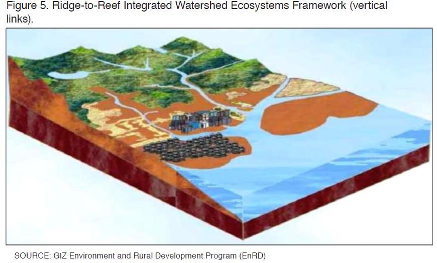
6 Enhancements in the CLUP Guidebook Integration of climate change adaptation and disaster risk reduction; Adoption of the ridge-to-reef or integrated watershed ecosystems management framework to emphasize the interrelationship between the upland, lowland and coastal ecosystems; 6
7 Enhancements in the CLUP Guidebook Integration of public and private land use management and newly mandated land and resource use regimes such as ancestral lands, biodiversity, cultural heritage, forestlands, coastal/inland waters and protected areas, among others; Inclusion of green growth/eco-efficiency and urban design considerations in urban development; 7
8 Enhancements in the CLUP Guidebook Establishment of inter-lgu and/or inter-agency arrangements to facilitate CLUP implementation; Emphasis on the precedence of spatial physical plans (at the regional/ provincial/ local levels), particularly the CLUP, over other forms of sectoral and development plans in the LGU; and Highlighting the linkage of CLUP to the PPFP and other plans (barangay plan and other area specific plans). 8
9 9
")
10 Human development should be planned in a manner that took full account of nature and natural processes - Ian McHarg: Design with Nature (1969) 10
11 Critical elements of a successful national land use policy The National Physical Framework Plan (NPFP) has primacy over all other types of plans being made for the country, including the Philippine Medium-Term Development Plan; The national land use policy and physical planning process shall be formulated following a combined bottom-up and top-down approach; 11
12 Critical elements of a successful national land use policy The NPFP, guides the planning and management of the country s land and other physical resources at the national and sub-national levels; The NPFP indicates broad spatial directions and development guidelines on the four major land use policy areas, namely, settlements development, production land use, protection land use, and infrastructure development; 12
13 Critical elements of a successful national land use policy The NPFP should be the reference point by which subsequent national and local sectoral or development plans are directly linked and aligned; All plans and programs prepared by national and local government agencies should be seen as contributing and supportive of the physical development objectives and goals of the adopted national, regional, and local physical plans. 13
 adopted in 1996")
14 The enhanced CLUP Guidebook advocates the principles of the Philippine Agenda 21 (PA21) adopted in
15 15
16 Philippine Agenda 21: the National Agenda for Sustainable Development PA 21 envisions a better quality of life for all through the development of a just, moral, creative, spiritual, economically-vibrant, caring, diverse yet cohesive society characterized by appropriate productivity, participatory and democratic process and living in harmony within the limits of the carrying capacity of nature and the integrity of creation. 16
17 Sustainable Development, according to PA 21 (1996) the harmonious integration of a sound and viable economy, responsible governance, social cohesion and ecological integrity, to ensure that development is a life-sustaining process. 17
18 Philippine Agenda 21 s Five Goal Elements 1. Poverty Reduction: Poverty is a central concern of sustainable development. Consistent with this, PA 21 has a poverty reduction agenda that includes measures to create an enabling economic environment for sustained and broad-based growth; improve employment, productivity and income; and attain food security. 18
19 Philippine Agenda 21 s Five Goal Elements 2. Social Equity: Social equity should mean allocation of resources on the bases of efficiency and equity to achieve balanced development. Efficiency and equity mean the channelling of resources to developing areas where greater economic benefits accumulate and where there is greater need, distribution being dependent on the practicality and urgency of needs. 19
20 Philippine Agenda 21 s Five Goal Elements 3. Empowerment and Good Governance: Empowerment is a precondition of informal choices. Good governance is a necessary precondition to empowerment, as empowerment is to good governance. These two are a defining element of each other. 20
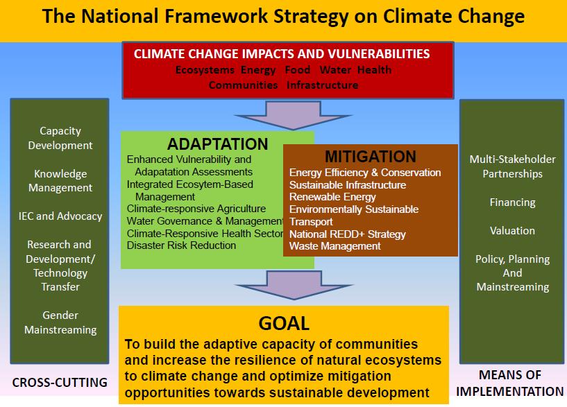
21 Philippine Agenda 21 s Five Goal Elements 4. Peace and Solidarity: The cycle of poverty and conflict goes on as the costs of war escalate in terms of various kinds of destruction while withholding funds for basic services, resulting in more poverty and underdevelopment. 21
22 Philippine Agenda 21 s Five Goal Elements 5. Ecological Integrity: In general, the path towards enhancing the integrity of the country s ecological domain will have to involve heightened and sustained implementation of environmental laws, as well as the continued pursuit of resource conservation, and environmental restoration/enhancement programs. 22
23 The enhanced CLUP Guidebook also promotes the principles, which are consistent with the planning and management of resources, provided for in the National Framework for Physical Planning (NFPP)
24 National Framework for Physical Planning ( ), principles Food security: Utilizing the country s land and water resources in a manner that provides sufficient and affordable food products to all Filipinos of the present and future generations through local production and/or importation. 24
25 National Framework for Physical Planning ( ), principles Environmental stability and ecological integrity: Achieving environmental stability through the observance of appropriate standards and ensuring ecological integrity through effective natural resource management and balancing the demand of land using activities vis-à-vis preservation of ecosystems. Ensuring the proper selection of a site to minimize the damage both to the environment and human health (Appropriate location principle) 25
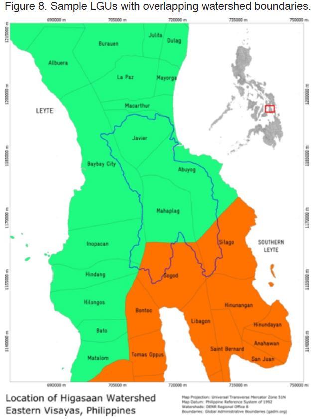
26 National Framework for Physical Planning ( ), principles Regional Urban Development: Encouraging the sustainable growth of cities and large towns while complementing the growth of rural areas by adopting alternative development approaches. Spatial Integration: Linking consumption and production areas to achieve physical and economic integration through appropriate infrastructure systems. 26
27 National Framework for Physical Planning ( ), principles Equitable access to physical and natural resources: Ensuring equitable access to resources through a just distribution of the country s resources and by providing equal opportunities to all Filipinos in the use and acquisition of land and other resources. Private-public sector partnership: Encouraging shared responsibility between the government and the private sector in the development and management of the country s physical resources. 27
28 National Framework for Physical Planning ( ), principles People Empowerment: Establishing pragmatic appropriate flexible and dynamic structures or mechanisms that involve the participation of key stakeholders. Recognition of the rights of indigenous people: Ensuring the Indigenous Peoples (IPs) right to develop, control, and use lands within their ancestral domains. 28
29 National Framework for Physical Planning ( ), principles Market orientation: Adopting the interplay of market forces within the framework of ecological and intergenerational factors as a basic parameter in the allocation and use of physical resources. 29
30 The enhanced CLUP Guidebook supports and complements the National Strategic Framework for Climate Change ( ) adopted by the Government of the Philippines as its national strategy towards ensuring and strengthening the adaptation of our natural ecosystems and human communities to climate change. 30
31 31
32 Integrated Ecosystem-based Management Addressing the country s multiple vulnerabilities to climate change requires an integrated ecosystem-based management approach which not only acknowledges the interrelationships across the country s ecosystems, but also strengthens the integrity of decision-making processes towards the formulation of comprehensive adaptation strategies from ridge-to-reef. 32
33 Local Climate Change Action Plan. The Climate Change Act aims to systematically integrate the concept of climate change in the policy formulation and development plans of all units of government to prepare for the impact of climate change. The Local Government Units (LGUs) have also been tasked to formulate and implement their respective Local Climate Change Action Plans (LCCAP) consistent with the Local Government Code, the NFSCC and the NCCAP. 33
34 Local Climate Change Action Plan. The Climate Change Commission envisions that the LCCAP should not represent a separate plan due to the multitude of plans already required of the LGUs. Rather, the LCCAP as an action plan, should be mainstreamed to the CLUP. Appropriate land use and land development is one of the most concrete ways to implement CCA and DRRM, and to harmonize these with sustainable development goals. 34
35 Planning Area The primary planning area is defined by the cities /municipalities political boundaries. This includes all component barangays and the city/municipal waters extending 15 kilometers from shoreline for coastal LGUs. 35
36 Planning Area Under the ridge-to-reef or integrated ecosystems management framework, the physical coverage area of an LGU s CLUP shall be referenced from the specific watershed/sub-watershed basin area within the municipality or city and other adjacent localities (transboundary). Thus, the CLUP shall cover both land and water resources of the city/municipality. However, it shall also consider other LGUs within the boundaries of its watershed/sub-watershed area 36
37 37
38 38
39 39
40 STEPS 1 and 2: Were the concerned stakeholders from various sector involved/ engaged in the planning process? 40
41 STEP 3: Set the vision In setting the vision, was it based on the results and findings of both baseline conditions or level of development achieved from the implementation of the existing CLUP and the projection and estimations of land use demands, demographic projections and spatial development patterns, climate change/disaster risk projections, biophysical and biodiversity conditions, and key local resource needs and capacities of Step 4? 41
42 STEP 4: Analyze the situation What were the issues, potentials and future development needs and spatial requirements of the city/municipality? Were they assessed using both technical and participatory methods? 42
43 43
44 44
45 Step 4: Analyze the Situation Sectoral and thematic studies Demographic/ socio-economic/ infrastructure-utilities profile Coastal and marine Forest Climate change and disaster risk Ancestral domain 45
46 Step 4: Analyze the Situation Sectoral and thematic studies Heritage Green growth Urban design Sectoral needs/issues/problems Projected/future land requirements 46
47 Step 4: Analyze the Situation Assessment of natural/physical environmental features Physical environmental profile Existing land uses (map and areas) Thematic and analytical maps Development constraints/ non-buildable areas Potential development areas 47
48 Step 4: Analyze the Situation Cross-sectoral analysis and integration of sectors and land uses LGU potentials and comparative advantages Priority issues and problems Possible interventions 48
49 49
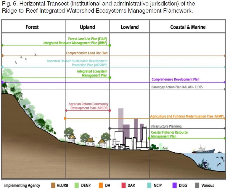
50 STEP 5: Set the goals and objective Were the formulated goals, objectives, outcomes, and output indicators achievable? Were they responsive to the issues, needs, and potentials, of the city/municipality? 50
51 51
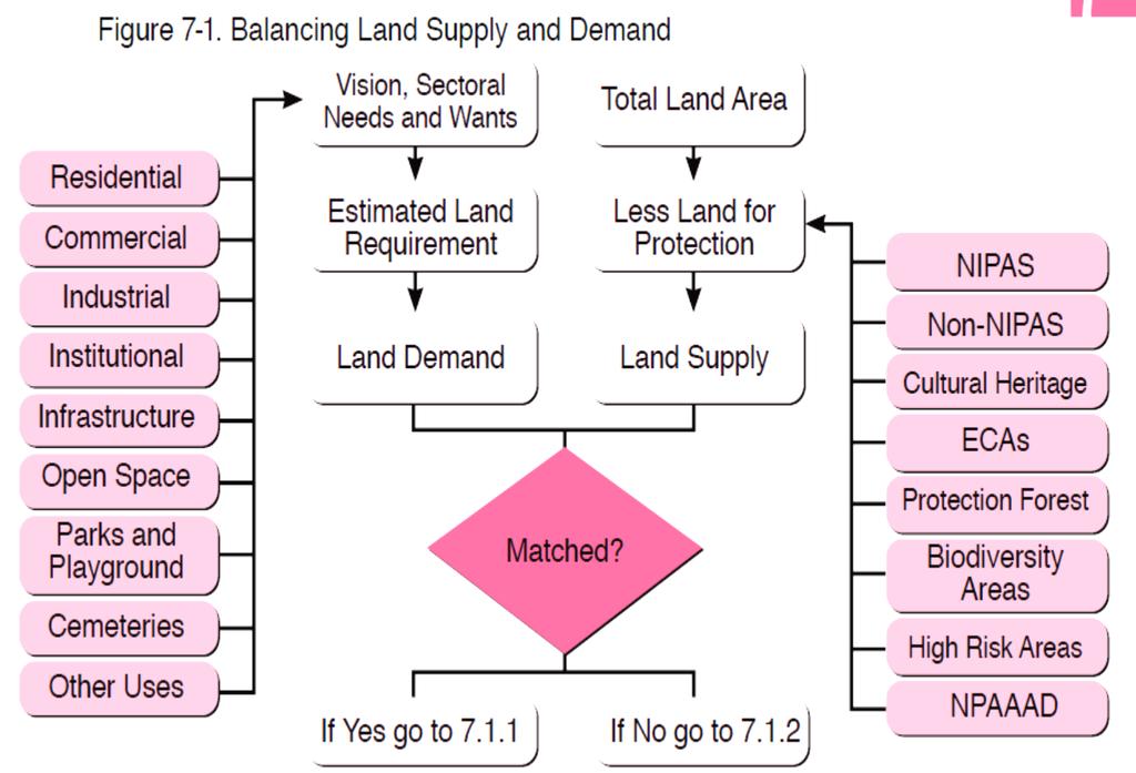
52 STEP 6: Establish Development Thrusts and Spatial Strategies Were the city/municipality s vision, goals, and objectives translated into various development alternatives or scenarios? (Note: the chosen scenario or a combination of scenarios shall serve as a framework for detailing the future land use plan) 52
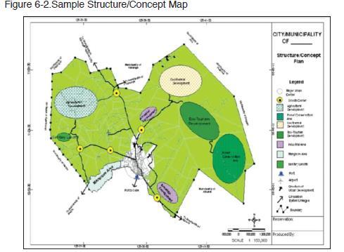
 Agricultural plains (agri-ecotourism) Upland forests (conservation/eco-tourism)")
53 Example Strategies: Coastal areas (aquaculture development) Urban center (urban redevelopment/ heritage conservation) Urban expansion area (light industrial development) Agricultural plains (agri-ecotourism) Upland forests (conservation/eco-tourism) 53
54 54
55 STEP 7: Prepare the Land Use Plan Were the vision, development thrust, and spatial strategies translated into a Land Use Plan that describes physically and spatially what, where, why, when, and how a LGU s land and water resources are allocated within its territorial jurisdiction (upland, lowland and coastal)? 55
56 STEP 7: Prepare the Land Use Plan Were the land and water resources of the LGU identified to be either under (a) protection and production use; (b) infrastructure; (c) urban, and (d) other development uses, consistent with and complementary to the CLUP s vision, development goals, and objectives? 56
57 Preparing the Land Use Plan In allocating and detailing of land uses, the Land Use Plan integrates the mandatory elements such as the transportation network, public facilities, economic development, ecologically critical areas, and natural hazards. 57
58 Preparing the Land Use Plan The Land Use Plan specifies the features of the preferred development thrust and spatial strategy, guided by the details and policies governing the following: Growth centers and corridors Residential developments and basic facilities/services Ecological system and cultural heritage protection/conservation Economic development and local governance Infrastructure support systems Development intent Use of city/municipal waters 58
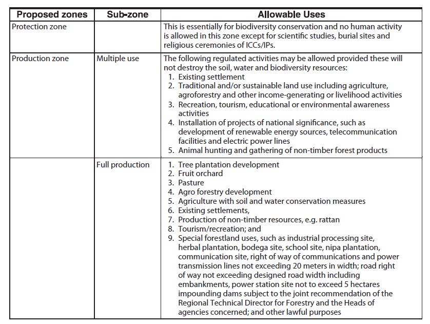
59 Preparing the Land Use Plan All related sectoral/thematic and development plans prepared by the LGU or national agencies shall be integrated into the CLUP such as the following: Forest Land Use Plan Coastal Resources Management Plan Tourism Master Plan Protected Area Management Plan Ancestral Domain Sustainable Development and Protection Plan Solid Waste Management Plan Agriculture Development Plan, etc. 59
60 Notes: The sectoral/thematic plans should complement and contribute to the attainment of the strategic objectives of the CLUP. Land use management and zoning arrangements of these sectoral/thematic plans should be consistent and made compatible with the designated local land use and zoning arrangements of the LGU. 60
61 Preparing the Land Use Plan The proposed Land Use Map will reflect the resultant land use proposals for the entire city/municipality, including coastal and marine areas. For purposes of having a more detailed presentation, the urban core and other urbanizing areas may be enlarged to a bigger scale to show the detailed land uses within. The components of urban use areas must be clearly specified and explicitly presented to avoid subjectivity of interpretation. 61
62 62
63 The Land Use Plan shall include the following: Proposed land and water uses Land and water use policies essential in physical development Proposed circulation network Major programs/ projects 63
64 STEP 8: Draft the Zoning Ordinance Were the zone boundaries defined/delineated in the map? 64
65 STEP 8: Draft the Zoning Ordinance Were the development controls and integrated zoning arrangements (for upland, lowland, and coastal areas) that will govern both public and private lands of the LGU formulated and reflected in a zoning map that shall accompany the CLUP? 65
66 STEP 8: Draft the Zoning Ordinance (Note: The zoning map shows the detailed zoning/ subzoning arrangements that will govern the specific land use categories identified in the CLUP) 66
67 Base Zones refers to the primary zoning classification of areas within a City/ Municipality that are provided with basic regulations such as a list of allowable uses. Usually done in conjunction with Overlay Zones Overlay Zones - a transparent zone that is overlain on top of the Base Zone or another Overlay Zone and provides an additional set [or layer] of regulations intended to address specific objectives for the zone in consideration. For example, an R-2 Zone (Base Zone) will be provided with a list of allowable uses. However, its location may be susceptible to flooding hence overlay regulations, such as requiring buildings/structures to be elevated, may be provided. This technique is useful in addressing CCA-DRR concerns. 67
68 Base Zones refers to the primary zoning classification of areas within a City/ Municipality that are provided with basic regulations such as a list of allowable uses. Usually done in conjunction with Overlay Zones Planned Unit Development (PUD) Zones is a form of Cluster Zoning intended to facilitate unitarily planned or masterplanned mixed-use developments, such as commercial, industrial and residential. 68
69 Base Zones Forest and Forest Land Use Zone -Protection -Production Agricultural Zone Protection Agricultural Sub-Zone Production Agricultural Sub-Zone Agri-Industrial Zone Municipal Waters Zone -Protection Sub-Zones: Fishery Refuge and Sanctuary, Foreshore Land, Mangroves, Fishery Reserve, Delta/Estuary, Lake 69
70 Base Zones -Production Sub-Zones: Mineral Land Zone Residential Zone 1-5 Socialized Housing Zone General Commercial Zone Commercial Zone 1-3 Industrial Zone 1-3 General Institutional Zone Tourism Zone Parks and Recreation Zone Cemetery Zone Buffer/Greenbelt Zone Utilities, Transportation, and Services (Infrastructure/Utilities) Zone 70
71 71
72 72
73 REFERENCES Enhanced CLUP Guidebook, HLURB, Volume 1 73

74 THANK YOU! 74
National Land Use Policy and National Integrated Planning Framework for Land Resource Development
 Title National Land Use Policy and National Integrated Planning Framework for Land Resource Development Duration: 32 Weeks Objective: Adoption of appropriate land use planning approaches to: Maintain the
International Guidelines on Access to Basic Services for All
 International Guidelines on Access to Basic Services for All Presentation and initials lessons from implementation Accessibility to services in regions and cities : measures and policies, OECD 18 June
THE SEVILLE STRATEGY ON BIOSPHERE RESERVES
 THE SEVILLE STRATEGY ON BIOSPHERE RESERVES 1 VISION FOR BIOSPHERE RESERVES IN THE 21 ST CENTURY The international Seville Conference on Biosphere Reserves, organised by UNESCO, adopted a two-pronged approach,
TOWARDS CLIMATE-RESILIENT COASTAL MANAGEMENT: OPPORTUNITIES FOR IMPROVED ICZM IN BELIZE
 TOWARDS CLIMATE-RESILIENT COASTAL MANAGEMENT: OPPORTUNITIES FOR IMPROVED ICZM IN BELIZE CHANTALLE SAMUELS Coastal Zone Management Authority and Institute The Caribbean Community Climate Change Centre VULNERABILITY
CHAPTER 4 HIGH LEVEL SPATIAL DEVELOPMENT FRAMEWORK (SDF) Page 95
 Page 95") CHAPTER 4 HIGH LEVEL SPATIAL DEVELOPMENT FRAMEWORK (SDF) Page 95 CHAPTER 4 HIGH LEVEL SPATIAL DEVELOPMENT FRAMEWORK 4.1 INTRODUCTION This chapter provides a high level overview of George Municipality s
CHAPTER 4 HIGH LEVEL SPATIAL DEVELOPMENT FRAMEWORK (SDF) Page 95 CHAPTER 4 HIGH LEVEL SPATIAL DEVELOPMENT FRAMEWORK 4.1 INTRODUCTION This chapter provides a high level overview of George Municipality s
THE SEVILLE STRATEGY FOR BIOSPHERE RESERVES BIOSPHERE RESERVES: THE FIRST TWENTY YEARS
 THE SEVILLE STRATEGY FOR BIOSPHERE RESERVES BIOSPHERE RESERVES: THE FIRST TWENTY YEARS Biosphere reserves are designed to deal with one of the most important questions the World faces today: How can we
The National Spatial Strategy
 Purpose of this Consultation Paper This paper seeks the views of a wide range of bodies, interests and members of the public on the issues which the National Spatial Strategy should address. These views
Together towards a Sustainable Urban Agenda
 Together towards a Sustainable Urban Agenda The City We (Youth) Want Preliminary findings from youth consultations Areas Issue Papers Policy Units 1.Social Cohesion and Equity - Livable Cities 2.Urban
16540/14 EE/cm 1 DG E 1A
 Council of the European Union Brussels, 5 December 2014 (OR. en) 16540/14 ENV 965 CULT 139 NOTE From: To: Subject: General Secretariat of the Council Delegations Charter of Rome on Natural and Cultural
The Governance of Land Use
 The planning system Levels of government and their responsibilities The Governance of Land Use COUNTRY FACT SHEET NORWAY Norway is a unitary state with three levels of government; the national level, 19
Land Use in the context of sustainable, smart and inclusive growth
 Land Use in the context of sustainable, smart and inclusive growth François Salgé Ministry of sustainable development France facilitator EUROGI vice president AFIGéO board member 1 Introduction e-content+
TOWARDS STRATEGIC SPATIAL PLANNING IN JAMAICA: THE NATIONAL SPATIAL PLAN
 TOWARDS STRATEGIC SPATIAL PLANNING IN JAMAICA: THE NATIONAL SPATIAL PLAN JIEP 5th Biennial Conference on the Environment: Balancing National Development and Environmental Protection June 6, 2011 Jamaica
THE SEVILLE STRATEGY FOR BIOSPHERE RESERVES
 THE SEVILLE STRATEGY FOR BIOSPHERE RESERVES BIOSPHERE RESERVES: THE FIRST TWENTY YEARS Biosphere reserves are designed to deal with one of the most important questions the World faces today: How can we
Tourism. April State Planning Policy state interest guideline. Department of Infrastructure, Local Government and Planning
 Department of Infrastructure, Local Government and Planning State Planning Policy state interest guideline Tourism April 2016 Great state. Great opportunity. Preface Using this state interest guideline
PACIFIC ISLANDS REGIONAL OCEAN POLICY. A healthy Ocean that sustains the livelihoods and aspirations of Pacific Island communities.
 PACIFIC ISLANDS REGIONAL OCEAN POLICY VISION A healthy Ocean that sustains the livelihoods and aspirations of Pacific Island communities. THIS IS OUR OCEAN 1. The care of the ocean is the responsibility
Governance and Urban Nexus: Closing the gaps
 Governance and Urban Nexus: Closing the gaps Donovan Storey Chief, Sustainable Urban Development, Environment & Development Division National Dialogue on Urban Nexus in Thailand Bangkok, UNCC, 19 March
Asia Protected Areas Charter
 資料 3-1 Asia Protected Areas Charter The Asia Challenge Asia is the world s most rapidly growing region as well as one of the most bio-diverse. This dynamic development has led to unprecedented growth,
Measurement of the Urban-Housing Deficit:
 Measurement of the Urban-Housing Deficit: Strategies, tools and sources of information The International Network for Urban and Regional Statistics Standing Committee of the International Association for
Urbanization and Sustainable Development of Cities: A Ready Engine to Promote Economic Growth and Cooperation
 Urbanization and Sustainable Development of Cities: A Ready Engine to Promote Economic Growth and Cooperation Wan Portia Hamzah Institute of Strategic and International Studies (ISIS) Malaysia 10 September
Outline National legislative & policy context Regional history with ESSIM ESSIM Evaluation Phase Government Integration via RCCOM Regional ICOM Framew
 What MSP Implementation could change in the Maritimes Region Tim Hall, Regional Manager Oceans and Coastal Management Division Ecosystem Management Branch Fisheries and Oceans Canada Maritimes Region BIO
CERTIFIED RESOLUTION. introduction: and dated May 29, 2017, as attached, as appropriate
 15322 Buena Vista Avenue, White Rock BC, Canada V4B 1Y6 www.whiterockcity.ca City of White Rock P: 604.541.22121 F: 604.541.9348 /2tC% City Clerk s Office IT E ROC K June 13,2017 Stephanie Lam, Deputy
ACTION PLAN FOR WORLD HERITAGE IN LATIN AMERICA AND THE CARIBBEAN ( )
") Annex ACTION PLAN FOR WORLD HERITAGE IN LATIN AMERICA AND THE CARIBBEAN (2014-2024) The current Regional Action Plan for Latin America and the Caribbean for 2014-2024 has been elaborated by the State Parties
Annex ACTION PLAN FOR WORLD HERITAGE IN LATIN AMERICA AND THE CARIBBEAN (2014-2024) The current Regional Action Plan for Latin America and the Caribbean for 2014-2024 has been elaborated by the State Parties
The Governance of Land Use
 The planning system The Governance of Land Use United Kingdom Levels of government and their responsibilities The United Kingdom is a unitary state with three devolved governments in Northern Ireland,
Proposed Scope of Work Village of Farmingdale Downtown Farmingdale BOA Step 2 BOA Nomination Study / Draft Generic Environmental Impact Statement
 Proposed Scope of Work Village of Farmingdale Downtown Farmingdale BOA Step 2 BOA Nomination Study / Draft Generic Environmental Impact Statement The scope of work that follows incorporates and covers
Measuring Disaster Risk for Urban areas in Asia-Pacific
 Measuring Disaster Risk for Urban areas in Asia-Pacific Acknowledgement: Trevor Clifford, Intl Consultant 1 SDG 11 Make cities and human settlements inclusive, safe, resilient and sustainable 11.1: By
Local Area Key Issues Paper No. 13: Southern Hinterland townships growth opportunities
 Draft Sunshine Coast Planning Scheme Review of Submissions Local Area Key Issues Paper No. 13: Southern Hinterland townships growth opportunities Key Issue: Growth opportunities for Southern Hinterland
Declaration Population and culture
 Declaration Population and culture The ministers of the parties to the Alpine Convention regard the socio-economic and socio-cultural aspects mentioned in Article 2, Paragraph 2, Item a., as being central
National Spatial Development Perspective (NSDP) Policy Coordination and Advisory Service
 Policy Coordination and Advisory Service") National Spatial Development Perspective (NSDP) Policy Coordination and Advisory Service 1 BACKGROUND The advances made in the First Decade by far supersede the weaknesses. Yet, if all indicators were
National Spatial Development Perspective (NSDP) Policy Coordination and Advisory Service 1 BACKGROUND The advances made in the First Decade by far supersede the weaknesses. Yet, if all indicators were
Urban Climate Resilience
 Urban Climate Resilience in Southeast Asia Partnership Project Introduction Planning for climate change is a daunting challenge for governments in the Mekong Region. Limited capacity at the municipal level,
Sustainable Development Goal 11 and the New Urban Agenda: can planning deliver? Vanessa Watson University of Cape Town 2016
 Sustainable Development Goal 11 and the New Urban Agenda: can planning deliver? Vanessa Watson University of Cape Town 2016 .to reinvigorate the global political commitment to the sustainable development
THE ROLE OF GEOSPATIAL AT THE WORLD BANK
 THE ROLE OF GEOSPATIAL AT THE WORLD BANK INSPIRE Conference Barcelona, Spain September 26, 2016 Kathrine Kelm Senior Land Administration Specialist Global Land and Geospatial Unit The World Bank Group
CORPORATION OF THE CITY OF COURTENAY COUNCIL MEETING AGENDA
 CORPORATION OF THE CITY OF COURTENAY COUNCIL MEETING AGENDA DATE: Monday, January 14, 2013 PLACE: City Hall Council Chambers TIME: 4:00 p.m. 1.00 ADOPTION OF MINUTES 1. Adopt January 7, 2013 Regular Council
PROMOTING NATURE CONSERVATION AND SUSTAINABLE AGRICULTURAL DEVELOPMENT IN THE RURAL AREAS OF HONG KONG
 1 PROMOTING NATURE CONSERVATION AND SUSTAINABLE AGRICULTURAL DEVELOPMENT IN THE RURAL AREAS OF HONG KONG Director of Agriculture, Fisheries and Conservation Dr. LEUNG Siu-fai A STONE S THROW AWAY FROM
Foundation Geospatial Information to serve National and Global Priorities
 Foundation Geospatial Information to serve National and Global Priorities Greg Scott Inter-Regional Advisor Global Geospatial Information Management United Nations Statistics Division UN-GGIM: A global
Assessment of Sustainable Land Use within the Town Planning Process Experiences with a Multi Criteria Approach (MCA)
") Assessment of Sustainable Land Use within the Town Planning Process Experiences with a Multi Criteria Approach (MCA) Dipl.-Geogr. Sophie Schetke Dipl.-Ing. Benedikt Frielinghaus, University of Bonn, Germany
Assessment of Sustainable Land Use within the Town Planning Process Experiences with a Multi Criteria Approach (MCA) Dipl.-Geogr. Sophie Schetke Dipl.-Ing. Benedikt Frielinghaus, University of Bonn, Germany
CLLD Cooperation OFFER
 Title of the proposed project (English) CLLD Cooperation OFFER PARKS PROTECTION III - Management, Protection and Economic Development in Protected Areas Type of project (select as many as you want) Cooperation
TERRITORIAL IMPACT ASSESSMENT: AN APPROACH TO IMPROVE THE VERTICAL AND HORIZONTAL INTEGRATION OF EU POLICIES
 TERRITORIAL IMPACT ASSESSMENT: AN APPROACH TO IMPROVE THE VERTICAL AND HORIZONTAL INTEGRATION OF EU POLICIES Naja Marot & Mojca Golobič Biotehnical Faculty, University of Ljubljana, Slovenia RSA Workshop
KUNMING FORUM ON UNITED NATIONS GLOBAL GEOSPATIAL INFORMATION MANAGEMENT CITIES OF THE FUTURE: SMART, RESILIENT
 KUNMING FORUM ON UNITED NATIONS GLOBAL GEOSPATIAL INFORMATION MANAGEMENT CITIES OF THE FUTURE: SMART, RESILIENT and SUSTAINABLE Yunnan Zhenzhuang Guest House, Kunming, China 10 12 May 2017 BACKGROUND CONCEPT
Shetland Islands Council
 Shetland Islands Council Response to EU Green Paper on Territorial Cohesion Shetland Islands Council is strongly in favour of a territorial dimension to cohesion policy and welcomes the Commission s consultation
What is Spatial Planning?
 Spatial Planning in the context of the Responsible Governance of Tenure What is Spatial Planning? Text-only version This course is funded by the European Union through the EU-FAO Improved Global Governance
November 29, World Urban Forum 6. Prosperity of Cities: Balancing Ecology, Economy and Equity. Concept Note
 November 29, 2010 World Urban Forum 6 Prosperity of Cities: Balancing Ecology, Economy and Equity Concept Note 1 CONTENT Thematic Continuity Conceptualizing the Theme The 6 Domains of Prosperity The WUF
Spatial Planning in the Republic of Armenia
 Spatial Planning in the Republic of Armenia According to the Law of the Republic of Armenia on Urban Development, the main issues of the Republic s spatial development and actions for their solution are
Tackling urban sprawl: towards a compact model of cities? David Ludlow University of the West of England (UWE) 19 June 2014
 19 June 2014") Tackling urban sprawl: towards a compact model of cities? David Ludlow University of the West of England (UWE) 19 June 2014 Impacts on Natural & Protected Areas why sprawl matters? Sprawl creates environmental,
Tackling urban sprawl: towards a compact model of cities? David Ludlow University of the West of England (UWE) 19 June 2014 Impacts on Natural & Protected Areas why sprawl matters? Sprawl creates environmental,
WELCOME & INTRODUCTION
 MPA Management Capacity Building Training Module 1: WELCOME & INTRODUCTION Participants Distinguished Guests Welcome Site Overviews of MPAs represented Overview of Training Program What are Today s Objectives?
Council Workshop on Neighbourhoods Thursday, October 4 th, :00 to 4:00 p.m. Burlington Performing Arts Centre
 Council Workshop on Neighbourhoods Thursday, October 4 th, 2012 1:00 to 4:00 p.m. Burlington Performing Arts Centre Agenda Introductions Warm-Up Exercise Presentation Exercise Neighbourhood Planning Break
Jordan's Strategic Research Agenda in cultural heritage
 Jordan's Strategic Research Agenda in cultural heritage Analysis of main results Alessandra Gandini Amman, Jordan 3 rd November 2013 Main objectives The work performed had the main objective of giving
EUSAIR on sea topics from Slovenian perspective
 MINISTRY OF FOREIGN AFFAIRS REPUBLIC OF SLOVENIA EUSAIR on sea topics from Slovenian perspective Mag. Andreja Jerina National Coordinator 4 EU MRS: 270 millions of population 19 MS 12 non MS Sea basin
EcoServ-GIS. EcoServ GIS Stage I. Why EcoServ GIS? 17/12/2012
 EcoServ-GIS Ecosystem Services Mapping: A Wildlife Trust GIS Toolkit to map ecosystem services at a county scale Dr Jonathan Winn Living Landscape Coordinator Durham Wildlife Trust Dr Chloe Bellamy Ecosystem
Building the Sustainable Network of Settlements on the Caspian Sea Region of Kazakhstan
 Building the Sustainable Network of Settlements on the Caspian Sea Region of Kazakhstan Introduction The Ecological Zoning and Identification of Ecological Capacity of Natural and Socio- Economic Potential
ikapa GDS White Paper Governance and Integration Department of the Premier Department of the Premier 2 December 2008
 ikapa GDS White Paper Governance and Integration Outline of presentation Western Cape Situation Strategic Framework Implementation Framework Alignment and implementation example Diversified economy Small
INTERNATIONAL CULTURAL TOURISM CHARTER Managing Tourism at Places of Heritage Significance (1999)
") INTERNATIONAL CULTURAL TOURISM CHARTER Managing Tourism at Places of Heritage Significance (1999) Adopted by ICOMOS at the 12th General Assembly in Mexico, October 1999. INTRODUCTION The Charter Ethos
INTERNATIONAL CULTURAL TOURISM CHARTER Managing Tourism at Places of Heritage Significance (1999) Adopted by ICOMOS at the 12th General Assembly in Mexico, October 1999. INTRODUCTION The Charter Ethos
Geospatial Technologies for Resources Planning & Management
 Geospatial Technologies for Resources Planning & Management Lal Samarakoon, PhD Director, Geoinformatics Center Asian Institute of Technology, Thailand Content Geoinformatics for SDG Information Integration
Towards international cooperation in the development of Marine Spatial Plans for the North Pacific: economic, social, and environmental dimensions
 Towards international cooperation in the development of Marine Spatial Plans for the North Pacific: economic, social, and environmental dimensions A.V. Sereda, V.B. Lobanov V.I. Il ichev Pacific Oceanological
Marine Spatial Planning: A Tool for Implementing Ecosystem-Based Management
 Marine Spatial Planning: A Tool for Implementing Ecosystem-Based Management Steven Murawski, Ph.D., Ecosystem Goal Team Lead National Oceanic and Atmospheric Administration NOAA November 16, 2009 1 To
SPLAN-Natura Towards an integrated spatial planning approach for Natura th January, 2017 Brussels. Commissioned by DG Environment
 SPLAN-Natura 2000 Towards an integrated spatial planning approach for Natura 2000 Commissioned by DG Environment 17 th January, 2017 Brussels V. Simeonova (Ph.D.) Drivers towards integrating Biodiversity
National Perspectives - Portugal. Margarida Almodovar
 National Perspectives - Portugal Margarida Almodovar margarida.almodovar@mam.gov.pt from base line to the external limit of the continental shelf behind 200 miles and according to UNCLOS definitions Economic
Haida Gwaii Queen Charlotte Islands
 Haida Gwaii Queen Charlotte Islands H E R I T A G E T O U R I S M STRATE GY January 2003 Haida Gwaii/Queen Charlotte Islands Heritage Tourism Strategy Working Group The Haida Gwaii/Queen Charlotte Islands
The European territory: Strategic developmentd
 The European territory: Strategic developmentd Peter Mehlbye Workshop Strategic Development Catalonia 11 June 2002 THE LECTURE Structure I. Territorial trends II. Strategy for European spatial development
DETERMINE OF REGIONAL DEVELOPMENT STRATEGIES IN IZMIR
 Sukran Yalpir Asli Bozdag Saban Inam DETERMINE OF REGIONAL DEVELOPMENT STRATEGIES IN IZMIR Globalization INTRODUCTION Economic pressure cause Economic migration cause cause Spatial organizations Spatial
Biodiversity and Protected Areas Management Project
 Biodiversity and Protected Areas Management Project Technical Advisor ESA region: Selwyn Willoughby Coordinator ESA region: Christine Mentzel FlexiCadastre EMEA Regional User Conference, Cape Town, South
COUNCIL OF THE EUROPEAN UNION. Brussels, 2 May /14 CULT 68
 COUNCIL OF THE EUROPEAN UNION Brussels, 2 May 2014 9129/14 CULT 68 NOTE from: General Secretariat of the Council to: Permanent Representatives Committee (Part 1) / Council No. prev. doc.: 8892/14 CULT
TP4D. Fostering territorial perspective for development. Towards a wider alliance
 Fostering territorial perspective for development Towards a wider alliance FOR several years, territorial approaches to development have been spreading within international organizations and among development
SPIMA Spatial dynamics and strategic planning in metropolitan areas
 SPIMA Spatial dynamics and strategic planning in metropolitan areas Dr. Vanya Simeonova Wageningen Environmental Research Wageningen University and research, The Netherlands Key outcomes: SPIMA Framework
Low Density Areas : Places of Opportunity. Enrique Garcilazo, OECD Directorate for Public Governance and Territorial Development
 Low Density Areas : Places of Opportunity Enrique Garcilazo, OECD Directorate for Public Governance and Territorial Development Open Days, Brussels, 11 th October, 2016 Outline 1. Performance low density
CONFERENCE STATEMENT
 CONFERENCE STATEMENT We, the elected representatives from Canada, Denmark/Greenland, Finland, Iceland, Norway, Russia, Sweden and the United States of America; In collaboration with the indigenous peoples
Disaster Management & Recovery Framework: The Surveyors Response
 Disaster Management & Recovery Framework: The Surveyors Response Greg Scott Inter-Regional Advisor Global Geospatial Information Management United Nations Statistics Division Department of Economic and
Realizing benefits of Spatial Data Infrastructure A user s perspective from Environment Agency - Abu Dhabi
 Realizing benefits of Spatial Data Infrastructure A user s perspective from Environment Agency - Abu Dhabi Anil Kumar Director, Environment Information Management 26 April 2012 Geospatial World Forum,
Key Indicators for Territorial Cohesion & Spatial Planning Stakeholder Workshop - Project Update. 13 th December 2012 San Sebastián, Basque Country
 Key Indicators for Territorial Cohesion & Spatial Planning Stakeholder Workshop - Project Update 13 th December 2012 San Sebastián, Basque Country Key Aims Explore the use of territorial data in developing
PURR: POTENTIAL OF RURAL REGIONS UK ESPON WORKSHOP Newcastle 23 rd November Neil Adams
 PURR: POTENTIAL OF RURAL REGIONS UK ESPON WORKSHOP Newcastle 23 rd November 2012 Neil Adams PURR: Potential of Rural Regions Introduction Context for the project A spectrum of knowledge Rural Potentials
THE ROLE OF SPATIAL PLANNING IN INTEGRATED COASTAL ZONE MANAGEMENT RECOMMENDATIONS FROM THE INTERREG III B BALTCOAST PROJECT
 THE ROLE OF SPATIAL PLANNING IN INTEGRATED COASTAL ZONE MANAGEMENT RECOMMENDATIONS FROM THE INTERREG III B BALTCOAST PROJECT DISCUSSION PAPER FOR THE TRANSNATIONAL WORKING GROUP DECEMBER 2004 CONTENT 1.
The Council Study: Social assessment approach and methodology
 Preliminary draft for internal discussion The Council Study: Social assessment approach and methodology Vientiane, September 24 2015 Social /economic assessment team Basin Development Plan (BDP) Programme
Summary. Recommendations on the Fifth Policy Document on Spatial Planning September 2001
 Summary Recommendations on the Fifth Policy Document on Spatial Planning September 2001 2 Introduction In December 2000 the Dutch Cabinet issued Part 1 of the Fifth National Policy Document on Spatial
Community Participation in Land Governance Through Citywide Community Mapping GLTN Learning Exchange, Bayview Hotel, Manila November 7, 2017
 Community Participation in Land Governance Through Citywide Community Mapping GLTN Learning Exchange, Bayview Hotel, Manila November 7, 2017 Community-Led, Citywide Settlement Profiling and Mapping as
The ESPON Programme. Goals Main Results Future
 The ESPON Programme Goals Main Results Future Structure 1. Goals Objectives and expectations Participation, organisation and networking Themes addressed in the applied research undertaken in ESPON projects
Introduction and Project Overview
 Greater New Orleans Regional Land Use Modeling GIS Techniques in a P olitical C ontext Louisiana Remote Sensing and GIS Workshop Wednesday, April 24, 2013 Working Towards a Shared Regional Vision Introduction
Land Use Planning and Agriculture: Austrian Experiences and Challenges I
 Land Use Planning and Agriculture: Austrian Experiences and Challenges I SULANET Summer School 2016 Walter Seher BOKU Vienna 1 Land Use Planning and Agriculture 2 Land Use Planning and Agriculture Agriculture
RETA 6422: Mainstreaming Environment for Poverty Reduction Category 2 Subproject
 RETA 6422: Mainstreaming Environment for Poverty Reduction Category 2 Subproject A. Basic Data 1. Subproject Title: Poverty-Environment Mapping to Support Decision Making 2. Country Director: Adrian Ruthenberg
Sustainable tourism in for Sustaibale Danang
 Sustainable tourism in for Sustaibale Danang A case study of Balearic Ecotax in Spain toward Sustainable tourism Miki Yoshizumi Associate Professor College of Gastronomy Management Ritsumeikan University
Experience and perspectives of using EU funds and other funding for the implementation of district renovation projects
 Experience and perspectives of using EU funds and other funding for the implementation of district renovation projects Ministry of the Interior of Lithuania Regional policy department Administration, coordination,
Implementing the Sustainable Development Goals: The Role of Geospatial Technology and Innovation
 Fifth High Level Forum on UN Global Geospatial Information Management Implementing the Sustainable Development Goals: The Role of Geospatial Technology and Innovation 28-30 November 2017 Sheraton Maria
Country Fiche Lithuania
 Country Fiche Lithuania Updated June 2018 1. General information The Lithuanian maritime space is delimited by the Decree of the Government of the Republic of Lithuania of 6 December, 2004, No. 1597 and
MODULE 1 INTRODUCING THE TOWNSHIP RENEWAL CHALLENGE
 MODULE 1 INTRODUCING THE TOWNSHIP RENEWAL CHALLENGE FOCUS OF THE MODULE Township renewal challenges and developmental outcomes covered in this module: Historical origins of townships and the inherited
Arctic ecosystem services: TEEB Arctic Scoping study. Alexander Shestakov WWF Global Arctic Programme 3 December Arctic Biodiversity Congress
 Arctic ecosystem services: TEEB Arctic Scoping study Alexander Shestakov WWF Global Arctic Programme 3 December 20143 Arctic Biodiversity Congress Content 1. Project design 2. Approach 3. Challenges and
Designing Networks of Marine Protected Areas in DFO s Three Atlantic Bioregions
 Designing Networks of Marine Protected Areas in DFO s Three Atlantic Bioregions Presentation for Indigenous Protected Areas Workshop Max Westhead, DFO and Adrian Gerhartz-Abraham, Dalhousie March 29, 2017
The CRP stresses a number of factors that point to both our changing demographics and our future opportunities with recommendations for:
 Plan Overview The CRP represents the first broad planning initiative covering Lake, Porter and LaPorte counties. Unlike previous plans released by NIRPC, which focused primarily on transportation, the
Integrated Infrastructure Planning & Spatial Mapping
 Integrated Infrastructure Planning & Spatial Mapping Presenter: Heidi Dixon, Principal Social Planner, DTPLI 23 May 2014 PART 1 PLAN MELBOURNE : Metropolitan Planning Strategy PART 2 Case Study: DTPLI
Uses of The Climate and Climate-related Hazard Information in The Adaptation Strategies for Development and Spatial Planning Assessments
 Uses of The Climate and Climate-related Hazard Information in The Adaptation Strategies for Development and Spatial Planning Assessments Wilmar Salim, ST., M. Reg. Dev., Ph.D. Yogyakarta Monday, March
Cross-border Maritime Spatial Plan for the Black sea - Romania and Bulgaria project
 Cross-border Maritime Spatial Plan for the Black sea - Romania and Bulgaria project in Romania and Bulgaria Plan Presentation A first step in the management of the marine areas of Romania and Bulgaria
Presentation by Thangavel Palanivel Senior Strategic Advisor and Chief Economist UNDP Regional Bureau for Asia-Pacific
 Presentation by Thangavel Palanivel Senior Strategic Advisor and Chief Economist UNDP Regional Bureau for Asia-Pacific The High-Level Euro-Asia Regional Meeting on Improving Cooperation on Transit, Trade
The purpose of this paper is to explain the concept
 THE INTER-DIMENSIONAL ANALYSIS OF URBAN DEVELOPMENT: A Guide to the Organisation of Cases and Their Linkages by Michael Safier Development Planning Unit (DPU) University College London Michael Safier 2001
The Governance of Land Use
 The planning system Levels of government and their responsibilities The Governance of Land Use Country fact sheet Germany Germany is a federal country with four levels of government. Below the national
The inland water related tourism in South Africa by 2030 in the light of global change
 The inland water related tourism in South Africa by 2030 in the light of global change KSA 2 Water-Linked Ecosystems T4: Green economy and sustainable (green) innovations K5/2620 How can natural capital
PUBLIC HEALTH ASSOCIATION OF AUSTRALIA Strategic Plan
 PUBLIC HEALTH ASSOCIATION OF AUSTRALIA Strategic Plan March 2017 20 Napier Close Deakin ACT Australia 2600 PO Box 319 Curtin ACT Australia 2605 Table of Contents Introduction... 2 Vision for a healthy
MEDIUM TERM DEVELOPMENT PLAN: RPJMN Director of Forestry and Water Resources Conservation Bappenas
 MEDIUM TERM DEVELOPMENT PLAN: RPJMN 2015-2019 Director of Forestry and Water Resources Conservation Bappenas Jakarta, 9 March 2015 1 I. RPJMN 2015-2019 2 VISION AND MISSION 2015-2019 VISION: INDONESIA:
GIS (GEOGRAPHICAL INFORMATION SYSTEMS) AS A FACILITATION TOOL FOR SUSTAINABLE DEVELOPMENT IN AFRICA
 AS A FACILITATION TOOL FOR SUSTAINABLE DEVELOPMENT IN AFRICA") GIS (GEOGRAPHICAL INFORMATION SYSTEMS) AS A FACILITATION TOOL FOR SUSTAINABLE DEVELOPMENT IN AFRICA a presentation by Elizabeth Hicken GDEST Conference on Geospatial Sciences for Sustainable Development
GIS (GEOGRAPHICAL INFORMATION SYSTEMS) AS A FACILITATION TOOL FOR SUSTAINABLE DEVELOPMENT IN AFRICA a presentation by Elizabeth Hicken GDEST Conference on Geospatial Sciences for Sustainable Development
Alps Results from the ESPON Project. Common spatial perspectives for the Alpine area. Towards a common vision
 Results from the ESPON Project Alps 2050 Common spatial perspectives for the Alpine area. Towards a common vision Tobias Chilla, University of Erlangen Cooperation Alps 2020+ 1 & 2 October 2018 Salzburg
Other effective area based conservation. The case of Colombia
 Other effective area based conservation measures (OECM): The case of Colombia Working group on Complementary Conservation Strategies Clara L. Matallana Humboldt Institute How is Colombia regarding Aichi
Asia Pacific Ministerial Conference on Housing and Urban Development (APMCHUD) Meeting of the Working Group on Urban and Rural Planning and Management
 Meeting of the Working Group on Urban and Rural Planning and Management") Asia Pacific Ministerial Conference on Housing and Urban Development (APMCHUD) Meeting of the Working Group on Urban and Rural Planning and Management August 16 17, 2012 New Delhi Recommendations of the
Asia Pacific Ministerial Conference on Housing and Urban Development (APMCHUD) Meeting of the Working Group on Urban and Rural Planning and Management August 16 17, 2012 New Delhi Recommendations of the
Economic Activity Economic A ctivity
 5 Economic Economic Activity Activity ECONOMIC ACTIVITY 5.1 EMPLOYMENT... 5-7 5.1.1 OBJECTIVE... 5-7 5.1.2 POLICIES... 5-7 5.2 PROTECTING THE AREA OF EMPLOYMENT... 5-9 5.2.1 OBJECTIVE... 5-9 5.2.2 POLICIES...
IMA s ROLE IN COASTAL AND OCEAN GOVERNANCE IN TRINIDAD AND TOBAGO
 IMA s ROLE IN COASTAL AND OCEAN GOVERNANCE IN TRINIDAD AND TOBAGO Presented by Rahanna Juman, Deputy Director (Ag.) About the Institute of Marine Affairs Institute of Marine Affairs (IMA) was established,