The ATU Decision Support System (DSS)
|
|
|
- Ethan Gray
- 5 years ago
- Views:
Transcription


1 The ATU Decision Support System (DSS)
2 The ATU Decision Support System (DSS) A decision support system to proactively manage streetworks
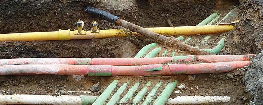
3 Streetworks Issues Street works are second highest concern of residents and businesses 2.2 million reinstatements per year 30% fail to meet the two year legal performance criteria Direct costs to local authorities are about 50m per year 17% reduction in the lifetime of a road Annual highway maintenance 2.5Bpa Annual carriageway maintenance 1.45Bpa Compensation claims 0.95Bpa Potholes 1.5m Utility openings 1.4m Money Time Safety


4 Key Challenges: Stakeholder Consultation System of Systems Knowledge-driven Approach Lack of a unified decision approach there is no one authority to plan and manage underground space, dependencies between assets are easily overlooked. Lack and dispersion of knowledge about asset management often in the form of tacit knowledge developed with extensive experience, new approaches not embedded into routine practice. Lack of a holistic costs analysis impact on other assets, as well as economic, environmental and societal impact.
5 surfacing binder base sub-base The Inter-related Role of Assets capping utility subgrade (ground) rainfall road road supports transmits ground ground utility transmits traffic load supports transmits leakage utility
6 Why an Integrated Approach? Hypothesis: Bad decisions are made for 2 reasons: 1) Lack of knowledge and data 2) Narrow interest above general interest If all the data and knowledge were available AND a holistic approach to decision making is taken better decisions would be made. Avoiding disruption! Saving money!
7 A video of the ATU DSS A quick overview of the DSS and its functionality A live demo will come later

8 The ATU-DSS: under the bonnet


9 DSS ARCHITECTURE Contextual Information Warnings Suggestions Automated Reasoning Knowledge base (Ontologies + rules) Real World Data
10 DSS ARCHITECTURE Contextual Information Warnings Suggestions Automated Reasoning Knowledge base (Ontologies + rules) Real World Data
11 What is an Ontology? Computer processable knowledge model of a domain Defines the key concepts to provide a unified view to facilitate data integration and intelligent decision support Specifies their properties and the relations between them
12 What is an Ontology? Computer processable knowledge model of a domain Defines the key concepts to provide a unified view to facilitate data integration and intelligent decision support Specifies their properties and the relations between them
13 ATU ONTOLOGIES: PURPOSE Define: main concepts related to underground assets Specify: their dependencies relationships with the natural environment: (e.g. rain) and human activities (e.g. digging a hole) Provide: a unified knowledge source supporting decisions related to urban streetworks diagnosis, planning, maintenance o how different assets affect each other; o how asset properties and processes affect each other o causes and effects of asset defects or failures o consequences of maintenance/repair activities
14 2 classes of ontologies in the ATU-DSS City infrastructure Asset ontologies road, ground, utilities Non Asset ontologies triggers, sensors/investigative techniques, environment Intra and Inter ontology relationships, e.g. processes
15 2 classes of ontologies in the ATU-DSS City infrastructure Asset ontologies road, ground, utilities Non Asset ontologies triggers, sensors/investigative techniques, environment Intra and Inter ontology relationships, e.g. processes Road Environment Ground Utilities
16 2 classes of ontologies in the ATU-DSS City infrastructure Asset ontologies road, ground, utilities Non Asset ontologies triggers, sensors/investigative techniques, environment Intra and Inter ontology relationships, e.g. processes Road Environment Ground Utilities
17 2 classes of ontologies in the ATU-DSS City infrastructure Asset ontologies road, ground, utilities Non Asset ontologies triggers, sensors/investigative techniques, environment Intra and Inter ontology relationships, e.g. processes Road Environment Ground Trigger Utilities
18 2 classes of ontologies in the ATU-DSS City infrastructure Asset ontologies road, ground, utilities Non Asset ontologies triggers, sensors/investigative techniques, environment Intra and Inter ontology relationships, e.g. processes Sensors/investigative Road Environment Ground Trigger Utilities
19 Ontology Structure: Asset ontologies Properties: Physical, chemical & mechanical composition of the ground capacity of a road pressure capacity of a pipe Processes that can change a property infiltration, deformation, pressure
20 Ontology Structure: Asset ontologies Properties: Physical, chemical & mechanical composition of the ground capacity of a road pressure capacity of a pipe Processes that can change a property infiltration, deformation, pressure property property process process
21 Ontology Structure: Asset ontologies Properties: Physical, chemical & mechanical composition of the ground capacity of a road pressure capacity of a pipe Processes that can change a property infiltration, deformation, pressure property property process process Infrastructure Asset Utility Ground Road Pipe Cable Drainage Duct
22 ATU ONTOLOGY: ROAD
23 ATU ONTOLOGIES: ROAD
24 ATU ONTOLOGIES: ROAD Hierarchy of road processes and properties
25 ATU ONTOLOGIES: ROAD Hierarchy of road processes and properties Relationships between properties and processes

26 ATU ONTOLOGIES: ROAD Hierarchy of road processes and properties And similarly for the other ontologies Relationships between properties and processes
27 Trigger Ontology A trigger, external to the asset, starts a chain reaction The triggers can be Environmental (e.g. excessive rainfall, reduction in temperature, change in traffic load) Observation (e.g. crack in road, pothole, drop in water pressure) Management (e.g. planned maintenance, utility replacement)
28 Inference and Rules Knowledge Base Facts relating to Scenario (instances of ontology classes) RoadCracking=active TrafficLoad=high Real World Data Rule Base Expert derived rules If RoadCracking=active and TrafficLoad=high Then RoadCrackingIntensity increases Inference Engine Derives new facts
29 Inference and Rules Knowledge Base Facts relating to Scenario (instances of ontology classes) RoadCracking=active TrafficLoad=high Real World Data Rule Base Expert derived rules If RoadCracking=active and TrafficLoad=high Then RoadCrackingIntensity increases Inference Engine Derives new facts
30 Inference and Rules Knowledge Base Facts relating to Scenario (instances of ontology classes) RoadCracking=active TrafficLoad=high RoadCrackingIntensity increases Real World Data Rule Base Expert derived rules If RoadCracking=active and TrafficLoad=high Then RoadCrackingIntensity increases Inference Engine Derives new facts
31 Key Challenge: Rules not always certain Conclusions of many rules are only (very) likely rather than definite. If Pipe Leak is small then[very Likely] Soil Wetting increased How to represent likelihoods? Unable to obtain quantitative probabilities (e.g. 0.9) Preferred linguistic terms: Definite Very Likely Likely Unlikely Very Unlikely How to reason with/combine such uncertain knowledge? Propagate these symbolic values Special algorithms for comparing uncertainty vectors
32 Key Challenge: Missing information/facts A rule might not get invoked because some the truth of some of its antecedents might not be known (yet) But the rule might predict a critical undesirable consequence We allow facts to be assumed: the rule can be invoked Assumed facts are flagged for checking later by user
33 Key Challenge: Explaining observations We may have a rule If Pipe leaking is active and subgrade is sand Then Road cracking is active If we observe road cracking and we know subgrade is sand, then an explanation may be that there is a pipe leak.
34 Summary Ontologies encode knowledge about the domain Rules encode expert heuristic knowledge Inference engine uses rules to infer new facts System handles missing knowledge, uncertain knowledge User can verify assumptions and alter facts dynamically and the inference will recompute as necessary.
35 ATU DSS A live demo
36 Summary so far You ve seen: the current prototype the challenges the vision A demo of the live system The underlying technology Coffee After the break: the future A new case study with Balfour Beatty A discussion on future
Geotechnical Risks and Management Systems: An FHWA Perspective
 October 13, 2010 2010 STGE Conference Charleston, WV Geotechnical Risks and Management Systems: An FHWA Perspective Silas C. Nichols, PE, Senior Bridge Engineer - Geotechnical Federal Highway Administration
MeteoGroup RoadMaster. The world s leading winter road weather solution
 MeteoGroup RoadMaster The world s leading winter road weather solution Discover why RoadMaster is the world s leading winter road weather solution. Managing winter road maintenance means that you carry
FROST HEAVE. GROUND FREEZING and FROST HEAVE
 FROST HEAVE The temperature of soils near the ground surface reflects the recent air temperatures. Thus, when the air temperature falls below 0 C (32 F) for extended periods, the soil temperature drops
Inflow and Infiltration. John Sorrell, P.E. City of Raleigh Public Utilities Department
 Inflow and Infiltration John Sorrell, P.E. City of Raleigh Public Utilities Department 1 Raleigh s History with I&I Our initial system was designed in 1888. Treatment began in the 1950 s What is I & I?
Existing road transport network of the National Capital Region was examined for the existing connectivity, mobility and accessibility in the study.
 2 Road Network 2.1 Existing Road Network The existing transport network in National Capital Region is radial in nature. It comprises of expressways, national highways, state highways, major district and
GIS for spatial decision making
 MASTERS DISSERTATION: GEOINFORMATICS GIS for spatial decision making Veldic Vlado 2001 - University of Pretoria GIS for spatial decision-making Veldic Vlado Submitted in partial fulfilment of the requirements
Jordan's Strategic Research Agenda in cultural heritage
 Jordan's Strategic Research Agenda in cultural heritage Analysis of main results Alessandra Gandini Amman, Jordan 3 rd November 2013 Main objectives The work performed had the main objective of giving
Digitalization in Shipping
 Digitalization in Shipping Tom Sundell VP Products, NAPA www.napa.fi NAPA Solutions for Safe and Efficient Ship Operations NAPA A very short introduction to NAPA NAPA for safety and efficiency of the industry
BALTRAD tailored ender-user product: Risk assessment map for urban drainage management
 BALTRAD tailored ender-user product: Risk assessment map for urban drainage management Authors: Jesper E. Nielsen, Michael R. Rasmussen (AAU) Date: December 2012 BALTRAD Document: BALTRAD+ W4-Risk assessment
INTRODUCTION TO PAVEMENT STRUCTURES
 INTRODUCTION TO PAVEMENT STRUCTURES A pavement is a structure composed of structural elements, whose function is to protect the natural subgrade and to carry the traffic safety and economically. As a wheel
USING GIS IN WATER SUPPLY AND SEWER MODELLING AND MANAGEMENT
 USING GIS IN WATER SUPPLY AND SEWER MODELLING AND MANAGEMENT HENRIETTE TAMAŠAUSKAS*, L.C. LARSEN, O. MARK DHI Water and Environment, Agern Allé 5 2970 Hørsholm, Denmark *Corresponding author, e-mail: htt@dhigroup.com
Linear Referencing Systems (LRS) Support for Municipal Asset Management Systems
 Support for Municipal Asset Management Systems") Linear Referencing Systems (LRS) Support for Municipal Asset Management Systems Esri Canada Infrastructure Asset Management Leadership Forum November 1, 2017 Toronto, ON David Loukes, P. Eng., FEC Andy
Linear Referencing Systems (LRS) Support for Municipal Asset Management Systems Esri Canada Infrastructure Asset Management Leadership Forum November 1, 2017 Toronto, ON David Loukes, P. Eng., FEC Andy
10/18/2016 The Hoosier Co. Inc W. 86th Street, Indianapolis, IN
 10/18/2016 The Hoosier Co. Inc. 5421 W. 86th Street, Indianapolis, IN 46268 1 Agenda What is RWIS? What options are available? Innovation/Improvement in Winter Operations & Maintenance Key RWIS sensing
Sri Lanka Strategic Cities Development Project (P130548)
") SOUTH ASIA Sri Lanka Social, Urban, Rural and Resilience Global Practice Global Practice IBRD/IDA Investment Project Financing FY 2014 Seq No: 10 ARCHIVED on 21-Dec-2018 ISR35436 Implementing Agencies:
SOUTH ASIA Sri Lanka Social, Urban, Rural and Resilience Global Practice Global Practice IBRD/IDA Investment Project Financing FY 2014 Seq No: 10 ARCHIVED on 21-Dec-2018 ISR35436 Implementing Agencies:
Using Weather and Climate Information for Landslide Prevention and Mitigation
 Using Weather and Climate Information for Landslide Prevention and Mitigation Professor Roy C. Sidle Disaster Prevention Research Institute Kyoto University, Japan International Workshop on Climate and
Geographical Information System (GIS) Prof. A. K. Gosain
 Prof. A. K. Gosain") Geographical Information System (GIS) Prof. A. K. Gosain gosain@civil.iitd.ernet.in Definition of GIS GIS - Geographic Information System or a particular information system applied to geographical data
Geographical Information System (GIS) Prof. A. K. Gosain gosain@civil.iitd.ernet.in Definition of GIS GIS - Geographic Information System or a particular information system applied to geographical data
Maritime Spatial Planning
 Maritime Spatial Planning The Dutch experience Kopenhagen 28 november 2012 Lodewijk.Abspoel@minienm.nl North Sea 2 Outline History of MSP in the Netherlands Spatial Plan for the Dutch EEZ, principles and
GOVERNMENT MAPPING WORKSHOP RECOVER Edmonton s Urban Wellness Plan Mapping Workshop December 4, 2017
 GOVERNMENT MAPPING WORKSHOP 12.4.17 RECOVER Edmonton s Urban Wellness Plan Mapping Workshop December 4, 2017 In July of 2017, City Council directed administration to develop RECOVER, Edmonton s Urban Wellness
Hydrological forecasting and decision making in Australia
 Hydrological forecasting and decision making in Australia Justin Robinson, Jeff Perkins and Bruce Quig Bureau of Meteorology, Australia The Bureau's Hydrological Forecasting Services Seasonal Forecasts
Storm Sewer Design [2]
![Storm Sewer Design [2]](/thumbs/82/86956590.jpg "Storm Sewer Design [2]") Class 5 [1] Storm Sewer Design 9. Check Q < Qf and Vmax > vf > Vmin. Vmin is normally specified to avoid sedimentation. This will normally be 1.0 m/s at pipe full condition. (BS EN 752 suggests that for
Class 5 [1] Storm Sewer Design 9. Check Q < Qf and Vmax > vf > Vmin. Vmin is normally specified to avoid sedimentation. This will normally be 1.0 m/s at pipe full condition. (BS EN 752 suggests that for
ECONOMIC AND FINANCIAL ANALYSIS
 Road Rehabilitation Project (RRP KIR 44281) ECONOMIC AND FINANCIAL ANALYSIS 1. Base and project alternatives. The base case against which changes in road provider and road user costs are compared for the
Geotechnical Risks and Slope Management Systems: An FHWA Perspective
 August 20, 2010 10 th Annual Technical Forum Geohazards Impacting Transportation in the Appalachian Region Geotechnical Risks and Slope Management Systems: An FHWA Perspective Silas C. Nichols, PE, Senior
WASTEWATER FLOW COMPONENTS
 Chapter 3 WASTEWATER FLOW COMPONENTS 3.1 INTRODUCTION A sanitary sewer collection system receives two flow components: dry weather flow (DWF) and wet weather flow (WWF). The Base Wastewater Flow (BWF)
38th UNWTO Affiliate Members Plenary Session Yerevan, Armenia, 4 October 2016
 38th UNWTO Affiliate Members Plenary Session Yerevan, Armenia, 4 October 2016 17:00-19:00 Open Debate 5: City Tourism Introduced and Moderated by Dr. Donald Hawkins George Washington University World urban
transportation research in policy making for addressing mobility problems, infrastructure and functionality issues in urban areas. This study explored
 ABSTRACT: Demand supply system are the three core clusters of transportation research in policy making for addressing mobility problems, infrastructure and functionality issues in urban areas. This study
Oman NSDI Supporting Economic Development. Saud Al-Nofli Director of Spatial Data Directorate General of NSDI, NCSI
 Oman NSDI Supporting Economic Development 2017 Saud Al-Nofli Director of Spatial Data Directorate General of NSDI, NCSI "It s critical to make correct decisions the first time to optimize the Investments
Flood Scenario Worksheet
 Flood Scenario Worksheet Scenario adapted from: http://www.epa.gov/watersecurity/tools/trainingcd/simple/source/scenario-8/ssc8-0.pdf Simple Tabletop Exercise, Interdependency Natural Disaster Scenario,
SECTION II Hydrological risk
 Chapter 3 Understanding disaster risk: hazard related risk issues SECTION II Hydrological risk Peter Salamon Coordinating lead author Hannah Cloke Lead author 3.4 Giuliano di Baldassarre Owen Landeg Florian
Oman NSDI Business Values and Future Directions. Hassan Alawi Alghazali Acting Director General National Spatial Data Infrastructure
 Oman NSDI Business Values and Future Directions Hassan Alawi Alghazali Acting Director General National Spatial Data Infrastructure Presentation Outline Geospatial Maturity Current Challenges NCSI s Role
Yoshinori KAWAMURA, Oriental Consultants Global Co., Ltd.
 Landslides along National Roads in Central Highland in Sri Lanka: Review on Current Situation and Suggestion for Further Development of Landslide Mitigation along Highways in Sri Lanka Yoshinori KAWAMURA,
MODERNIZATION OF THE MUNICIPAL MAPPING USING HIGH END GNSS SYSTEM AND GIS SOFTWARE
 MODERNIZATION OF THE MUNICIPAL MAPPING USING HIGH END GNSS SYSTEM AND GIS SOFTWARE Mr. R. A. R. Khan Assistant Engineer, Sewerage Utility Management Centre (SUMC) Municipal Corporation Of Greater Mumbai
Introduction to Artificial Intelligence. Prof. Inkyu Moon Dept. of Robotics Engineering, DGIST
 Introduction to Artificial Intelligence Prof. Inkyu Moon Dept. of Robotics Engineering, DGIST Chapter 3 Uncertainty management in rule-based expert systems To help interpret Bayesian reasoning in expert
INTEGRATED REMOTE SENSING AND VISUALIZATION (IRSV) SYSTEM FOR TRANSPORTATION INFRASTRUCTURE. Project Description and Year I Achievement Report
 SYSTEM FOR TRANSPORTATION INFRASTRUCTURE. Project Description and Year I Achievement Report") INTEGRATED REMOTE SENSING AND VISUALIZATION (IRSV) SYSTEM FOR TRANSPORTATION INFRASTRUCTURE OPERATIONS AND MANAGEMENT Project Description and Year I Achievement Report p PROJECT OVERVIEW Project Goals:
INTEGRATED REMOTE SENSING AND VISUALIZATION (IRSV) SYSTEM FOR TRANSPORTATION INFRASTRUCTURE OPERATIONS AND MANAGEMENT Project Description and Year I Achievement Report p PROJECT OVERVIEW Project Goals:
Municipal Act, 2001 Loi de 2001 sur les municipalités
 Municipal Act, 2001 Loi de 2001 sur les municipalités ONTARIO REGULATION 239/02 MINIMUM MAINTENANCE STANDARDS FOR MUNICIPAL HIGHWAYS Consolidation Period: From January 25, 2013 to the e-laws currency date.
1 INTRODUCTION. 1.1 Context
 1 INTRODUCTION 1.1 Context During the last 30 years ski run construction has been one of the major human activities affecting the Alpine environment. The impact of skiing on environmental factors and processes,
Paul Bridge Meteorologist Vaisala/UKMO Work Groups/Committees: WMO/TRB/AMS
 Paul Bridge Meteorologist Vaisala/UKMO Work Groups/Committees: WMO/TRB/AMS Introduction (a) Identify and establish, if possible, inventories of transport networks in the ECE region which are vulnerable
Challenges of Portuguese urban planning instruments and practice
 Challenges of Portuguese urban planning instruments and practice Demonstrating a DSS integrating space syntax Miguel SERRA 1 ; Jorge GIL 2 ; Paulo PINHO 3 1 Citta Research Centre for the Territory, Transports
Climate changes in Norway: Factors affecting pavement performance
 Climate changes in Norway: Factors affecting pavement performance P. O. Aursand, Norwegian Public Roads Administration (NPRA), Norway R. Evensen, ViaNova Plan and traffic, Norway B. O. Lerfald, Veidekke
ALASKA ITS. Vehicles and Observations in the cloud
 ALASKA ITS Vehicles and Observations in the cloud 1 YOUR PRESENTERS Wilf Nixon, Salt Institute Mark DeVries, Vaisala Dan Schacher, ADOT&PF 2 Today s Agenda A Cloud Based Overview connected and autonomous
1 PROJECT BACKGROUND. August 14, Alberta Transportation Central Region #401, Street Red Deer, Alberta T4N 6K8
 August 14, 2013 Alberta Transportation Central Region #401, 4902 51 Street Red Deer, Alberta T4N 6K8 Mr. Dennis Grace, P.Eng. Construction Engineer Dear Mr. Grace: Central Region Geohazard Assessment 2013
Thoughts toward autonomous land development. Introduction
 Thoughts toward autonomous land development Spatial Transformation of Regular grid Irrigation Frameworks Bangkok and Cairo A Work in Progress Information based on student workshop June 2009 and earlier
Risk and Safety in Civil, Surveying and Environmental Engineering
 Risk and Safety in Civil, Surveying and Environmental Engineering Prof. Dr. Michael Havbro Faber ETH Zurich, Switzerland Contents of Today's Lecture Introduction to structural systems reliability General
The Reporting of Winter Road Conditions A panel discussion of how and the implications of reporting road status and conditions
 A panel discussion of how and the implications of reporting road status and conditions With Staff Sargent Gary McBratney-Metro Toronto Police, Traffic Services and Warren Nicholishen-Supervisor of Roads
Danielle Danielsson, BSc, Toowoomba Regional Council, Queensland
 Danielle Danielsson, BSc, Toowoomba Regional Council, Queensland 1 Toowoomba 2 8 years of drought...and then flooding rains. 3 Our Water supply 4 Our Sewerage System 5 Lots of assets to manage 6 Asset
GIS-T 2010 Building a Successful Geospatial Data Sharing Framework: A Ohio DOT Success Story
 GIS-T 2010 Building a Successful Geospatial Data Sharing Framework: A Ohio DOT Success Story ODOT District 2 GIS John Puente District 1 GIS Coordinator\ Planning Administrator 2 Interoperability 3 District
Quantifying Uncertainty & Probabilistic Reasoning. Abdulla AlKhenji Khaled AlEmadi Mohammed AlAnsari
 Quantifying Uncertainty & Probabilistic Reasoning Abdulla AlKhenji Khaled AlEmadi Mohammed AlAnsari Outline Previous Implementations What is Uncertainty? Acting Under Uncertainty Rational Decisions Basic
THE FLOODRESILIENCITY PROJECT
 THE FLOODRESILIENCITY PROJECT Tony Maguire, Senior Executive Engineer, Environment & Engineering Department, Dublin City Council. EWA SYMPOSIUM IFAT 2010 Note all photos & graphics FRC Project; Dublin
1 City of Edmonton Quesnell Bridge, Roads and Associated Structures Assessment
 1 City of Edmonton Quesnell Bridge, Roads and Associated Structures Assessment 1.1 Background Within the First National Engineering Vulnerability Assessment, the Public Infrastructure Engineering Vulnerability
ECONOMIC AND FINANCIAL ANALYSIS
 Additional Financing of Road Rehabilitation Project (RRP KIR 44281-014) ECONOMIC AND FINANCIAL ANALYSIS 1. Base and project scenarios. Without urgent rehabilitation works, it is expected that sections
Comprehensive Winter Maintenance Management System BORRMA-web MDSS inside to increase Road Safety and Traffic Flow
 Thorsten Cypra 1 Comprehensive Winter Maintenance Management System BORRMA-web MDSS inside to increase Road Safety and Traffic Flow American Public Works Association (APWA) Monday, 04/14/2008 3:30 4:30
Methodological approaches to urban hazard and risk assessment. Victor Jetten. Cees van Westen, Richard Sliuzas, Norman Kerle, Anne van Veen
 Methodological approaches to urban hazard and risk assessment Victor Jetten Cees van Westen, Richard Sliuzas, Norman Kerle, Anne van Veen Dept. of Earth Systems Analysis, ITC UN-GGIM Chengduforum15-17
Liquefaction induced ground damage in the Canterbury earthquakes: predictions vs. reality
 Bowen, H. J. & Jacka, M. E. () Proc. th NZGS Geotechnical Symposium. Ed. CY Chin, Queenstown Liquefaction induced ground damage in the Canterbury earthquakes: predictions vs. reality H J Bowen & M E Jacka
Logic and Decision Theory
 Logic and Decision Theory The prisoner s dilemma Deciding whether or not to take an umbrella Smart choices Combining decision theory and abduction in Abductive Logic Programming (ALP) ALP gives a logical
Landslide FE Stability Analysis
 Landslide FE Stability Analysis L. Kellezi Dept. of Geotechnical Engineering, GEO-Danish Geotechnical Institute, Denmark S. Allkja Altea & Geostudio 2000, Albania P. B. Hansen Dept. of Geotechnical Engineering,
NCEES Fundamentals of Engineering (FE) Examination CIVIL EXAM SPECIFICATIONS
 Examination CIVIL EXAM SPECIFICATIONS") NCEES Fundamentals of Engineering (FE) Examination CIVIL EXAM SPECIFICATIONS Effective Beginning with the April 2009 Examinations The FE examination is an 8-hour supplied-reference examination: 120 questions
NCEES Fundamentals of Engineering (FE) Examination CIVIL EXAM SPECIFICATIONS Effective Beginning with the April 2009 Examinations The FE examination is an 8-hour supplied-reference examination: 120 questions
REASONING UNDER UNCERTAINTY: CERTAINTY THEORY
 REASONING UNDER UNCERTAINTY: CERTAINTY THEORY Table of Content Introduction Certainty Theory Definition Certainty Theory: Values Interpretation Certainty Theory: Representation Certainty Factor Propagation
Chapter 10: BIM for Facilitation of Land Administration Systems in Australia
 Chapter 10: BIM for Facilitation of Land Administration Systems in Australia Sam Amirebrahimi Introduction With the introduction of the concept of 3D Cadastre and extensive efforts in this area, currently
A new design approach for highway rock slope cuts based on ecological environment protection
 A new design approach for highway rock slope cuts based on ecological environment protection T. Lian-jin, Z. Li, W. Yunjie, W. Guang-yuan & Z. Yin-tao College of Architecture and Civil Engineering, Beijing
City of Phoenix Pavement Management System. Ryan Stevens Civil Engineer III Street Transportation Department November 15, 2017
 City of Phoenix Pavement Management System Ryan Stevens Civil Engineer III Street Transportation Department November 15, 2017 Outline City of Phoenix Street Network Automated data collection Distresses
A software prototype for assessing the reliability of a concrete bridge superstructure subjected to chloride-induced reinforcement corrosion
 A software prototype for assessing the reliability of a concrete bridge superstructure subjected to chloride-induced reinforcement corrosion Ronald Schneider BAM Federal Institute for Materials Research
Measuring the Sustainable Performance of Public Infrastructure
 Measuring the Sustainable Performance of Public Infrastructure Mike Benson, MIT University of New Brunswick, Masters Candidate Jeff Rankin, P.Eng. University of New Brunswick, Chair in Construction Engineering
Climate Change Engineering Vulnerability Assessment. Coquihalla Highway (B.C. Highway 5) Between Nicolum River and Dry Gulch
 Between Nicolum River and Dry Gulch") SSuum mm maarryy ffoorr PPoolliiccyy M Maakkeerrss Climate Change Engineering Vulnerability Assessment Rev 2 June 2, 2010 Rev 2 June 2, 2010 Page 2 of 7 1 Conclusion 1.1 Adaptive Management Process BCMoTI
SSuum mm maarryy ffoorr PPoolliiccyy M Maakkeerrss Climate Change Engineering Vulnerability Assessment Rev 2 June 2, 2010 Rev 2 June 2, 2010 Page 2 of 7 1 Conclusion 1.1 Adaptive Management Process BCMoTI
A Preliminary Model of Community-based Integrated Information System for Urban Spatial Development
 A Preliminary Model of Community-based Integrated Information System for Urban Spatial Development Bauni HAMID 1, Devin DEFRIZA 2 1 2 CAITAD (Center of Applied Information Technology in Planning and Design),
HORIZONTAL INTEGRATION OF KNOWLEDGE
 Proceedings of the Twelfth IASTED International Conference Artificial Intelligence and Soft Computing (ASC 2008) September 1-3, 2008 Palma de Mallorca, Spain HORIZONTAL INTEGRATION OF KNOWLEDGE 1,.2 Dana
GEOSYNTHETICS ENGINEERING: IN THEORY AND PRACTICE
 GEOSYNTHETICS ENGINEERING: IN THEORY AND PRACTICE Prof. J. N. Mandal Department of civil engineering, IIT Bombay, Powai, Mumbai 400076, India. Tel.022-25767328 email: cejnm@civil.iitb.ac.in Module-5 LECTURE-
This report was prepared by Klohn Crippen Consultants Ltd. for Alberta Transportation Central Region under Contract No. CE053/2000.
 Alberta Transportation Central Region #401, 4902 51 Street Red Deer, Alberta T4N 6K8 June 7, 2002 Mr. Melvin Mayfield, P.Eng. Project Engineer Dear Mr. Mayfield: Central Region Landslide Assessment Site
GIS = Geographic Information Systems;
 What is GIS GIS = Geographic Information Systems; What Information are we talking about? Information about anything that has a place (e.g. locations of features, address of people) on Earth s surface,
Todd N. Loar, PG, CEG
 1 USACE DAM RISK ASSESSMENT PROGRAM OVERVIEW AND HOW ENGINEERING GEOLOGY CONTRIBUTES TO THE LEVEL OF CONFIDENCE AND RESULTS 255 255 255 237 237 237 217 217 217 200 200 200 0 0 0 163 163 163 131 132 122
Critical Borehole Orientations Rock Mechanics Aspects
 Critical Borehole Orientations Rock Mechanics Aspects By R. BRAUN* Abstract This article discusses rock mechanics aspects of the relationship between borehole stability and borehole orientation. Two kinds
Permeable Pavement Overview
 Permeable Pavement Overview Meeting of CCPIC City of Berkeley City of Davis City of Martinez 6 April 2018 Permeable Pavement Team and Sponsors Contributors to published work presented: David Jones, Hui
Current Research Trends from an Australian Perspective. Dr Philip Collier Research Director
 Current Research Trends from an Australian Perspective Dr Philip Collier Research Director Growth in the spatial sector. 11% pa in the Global Navigation Satellite System market 2010-2020 300% growth in
Spatially Enabled Society
 International Seminar on Land Administration Trends and Issues in Asia and the Pacific Region Spatially Enabled Society Abbas Rajabifard Vice Chair PCGIAP-WG3 Vice-President (President Elect), GSDI Association
Auckland Transport. Auckland Council. Statement of Evidence of Simon John Ferneyhough
 Under the Resource Management Act 1991 In the matter of Notices of Requirement to enable the construction, operation and maintenance of the City Rail Link Between Auckland Transport Requiring Authority
Future Global Data-processing and Forecasting System (GDPFS)
") Future Global Data-processing and Forecasting System (GDPFS) Enabling Seamless Activities from Research to Operations to Service (R2O2S) for the benefits of Members Michel Jean President of CBS The GDPFS
Future Global Data-processing and Forecasting System (GDPFS) Enabling Seamless Activities from Research to Operations to Service (R2O2S) for the benefits of Members Michel Jean President of CBS The GDPFS
ArcGIS Maps for Power BI An Introduction. DJ Berry Scott Ball
 ArcGIS Maps for Power BI An Introduction DJ Berry Scott Ball Agenda Introduction to ArcGIS Maps for Power BI ArcGIS Maps for Power BI overview Esri + Microsoft = Better Together Visualizing Power BI data
How advances in atmospheric modelling are used for improved flood forecasting. Dr Michaela Bray Cardiff University
 How advances in atmospheric modelling are used for improved flood forecasting Dr Michaela Bray Cardiff University Overview of current short term rainfall forecasting Advancements and on going research
Recognition Of Harpooning Danger Is A Very Long And Slow Learning Curve
 Recognition Of Harpooning Danger Is A Very Long And Slow Learning Curve Posting Date: 6-Nov-2016 Figure 1: News media photo from February 21, 2016 of a car that was harpooned by a horizontal railing at
1The Many Uses of GIS
 1The Many Uses of GIS BUILDING EUROPEAN SPATIAL DATA INFRASTRUCTURES In April 2006, Esri president Jack Dangermond gave a presentation on the INSPIRE Directive at the European Union (EU) Interparliamentary
PLANNING TRAFFIC SAFETY IN URBAN TRANSPORTATION NETWORKS: A SIMULATION-BASED EVALUATION PROCEDURE
 PLANNING TRAFFIC SAFETY IN URBAN TRANSPORTATION NETWORKS: A SIMULATION-BASED EVALUATION PROCEDURE Michele Ottomanelli and Domenico Sassanelli Polytechnic of Bari Dept. of Highways and Transportation EU
Dublin Chamber submission on Dublin City Development Plan : Outdoor Advertising Strategy
 Dublin Chamber submission on Dublin City Development Plan 2011 2017: Outdoor Advertising Strategy January 2012 Key Points: Sustainable and appropriate advertising can play an important positive role in
This is a repository copy of Uncertainty Management for Rule-Based Decision Support Systems.
 This is a repository copy of Uncertainty Management for Rule-Based Decision Support Systems. White Rose Research Online URL for this paper: http://eprints.whiterose.ac.uk/123450/ Version: Accepted Version
ShakeAlert Phase 1: West Coast Earthquake Early Warning. Doug Given, USGS EEW Coordinator Education Symposium, Dec. 4, 2018
 ShakeAlert Phase 1: West Coast Earthquake Early Warning Doug Given, USGS EEW Coordinator Education Symposium, Dec. 4, 2018 Population WA 7M OR 4M Annualized Earthquake Losses, $6.1B 61% in California,
Analysis of pavement structural performance for future climate
 P2R2C2 Analysis of pavement structural performance for future climate Report No. 7 July 2010 Project Coordinator University of Nottingham, UK ZAG, Slovenia VTT, Finland SINTEF, Norway This project was
INFORMATION SYSTEM OF FORECASTING INFRASTRUCTURE DEVELOPMENT IN TOURISM
 Management of Natural Disaster Mitigation Systems and Practical Examples UDC: 007:338.8 DOI: 10.2298/IJGI1303279G INFORMATION SYSTEM OF FORECASTING INFRASTRUCTURE DEVELOPMENT IN TOURISM Bogdan Gats*, Petro
Implementation of GISystems in the Land Acquisition Process and Road Maintenance. Immaculate Katutsi Uganda National Roads Authority
 Implementation of GISystems in the Land Acquisition Process and Road Maintenance Immaculate Katutsi Uganda National Roads Authority Stage 1 Stage 2 Stage 3 2 The Road construction process/ Project flow
Deep Thunder. Local Area Precision Forecasting for Weather-Sensitive Business Operations (e.g. Electric Utility)
") 1 Deep Thunder Local Area Precision Forecasting for Weather-Sensitive Business Operations (e.g. Electric Utility) Dipl. Ing. Helmut Ludwar Chief Technologist Wien, im Oktober 2010 Forecasts for Weather-Sensitive
1 Deep Thunder Local Area Precision Forecasting for Weather-Sensitive Business Operations (e.g. Electric Utility) Dipl. Ing. Helmut Ludwar Chief Technologist Wien, im Oktober 2010 Forecasts for Weather-Sensitive
Comparison of core sampling and visual inspection for assessment of sewer pipe condition
 Comparison of core sampling and visual inspection for assessment of sewer pipe condition N. Stanić, C. de Haan, M. Tirion, J. Langeveld and F. Clemens 9 th International Joint IWA/IAHR Conference on Urban
Landslide Hazard Zonation Methods: A Critical Review
 International Journal of Civil Engineering Research. ISSN 2278-3652 Volume 5, Number 3 (2014), pp. 215-220 Research India Publications http://www.ripublication.com/ijcer.htm Landslide Hazard Zonation Methods:
The sensitivity of repeated profile measurements to pavement unevenness and surface conditions
 CONTROL ENGINEERING The sensitivity of repeated profile measurements to pavement unevenness and surface conditions ENEA SOGNO and MICHELE MORI Prague, 20.10.2016 Summary The company Business sectors Accreditation
Abstract. Keywords: Geographic information systems and digital data model. 1. Introduction
 Abstract GISMO - A Geographical Information System for a Municipality Office Ramzi A. Haraty and Youssef O. Kaddoura Lebanese American University P.O. Box 13-5053 Chouran Beirut, Lebanon 1102 2801 Email:
Understanding Weather and Climate Risk. Matthew Perry Sharing an Uncertain World Conference The Geological Society, 13 July 2017
 Understanding Weather and Climate Risk Matthew Perry Sharing an Uncertain World Conference The Geological Society, 13 July 2017 What is risk in a weather and climate context? Hazard: something with the
TOOLS FOR RISK MANAGEMENT Related to climate change
 TOOLS FOR RISK MANAGEMENT Related to climate change copyright CONTENT 1 CLIMATE CHANGE AND ENVIRONMENTAL STUDIES 2 METHODS AND TOOLS DEVELOPED BY EGIS For infrastructures For urban areas For crisis management
THE SPATIAL DATA WAREHOUSE OF SEOUL
 THE SPATIAL DATA WAREHOUSE OF SEOUL Jae-Ho Han The Seoul Metropolitan Government Seoul City Hall, Taepyeongno 1(il)-ga, Jung-gu, Seoul 100-744, Korea djhjha@hanmail.net Impyeong Lee Dept. of Geoinformatics,
The Architecture of the Georgia Basin Digital Library: Using geoscientific knowledge in sustainable development
 GEOLOGIJA 46/2, 343 348, Ljubljana 2003 The Architecture of the Georgia Basin Digital Library: Using geoscientific knowledge in sustainable development B. BRODARIC 1, M. JOURNEAY 2, S. TALWAR 2,3, R. HARRAP
SPIMA Spatial dynamics and strategic planning in metropolitan areas
 Targeted Analysis SPIMA Spatial dynamics and strategic planning in metropolitan areas Executive Summary Conference version 1 February 2018 0 1. Background To address the challenges of metropolitan development
Effective placement of sensors for efficient early warning system in water distribution network MASHREKI ISLAM SAMI
 Effective placement of sensors for efficient early warning system in water distribution network MASHREKI ISLAM SAMI AGENDA Introduction and Problem Statement Methodology Experimentation and Analysis Limitations
Survey Questionnaire Compilation & Analysis of Feedback Co-deployment of OFC along the RoW of Highways
 Survey Questionnaire Compilation & Analysis of Feedback Co-deployment of OFC along the RoW of Highways Part of thestudy Co-deployment of Fibre Optic Cables Survey to Gather Information about Status & Practices
PW 001 SNOW REMOVAL AND SANDING FOR ROADWAYS AND SIDEWALKS October 6, 2014 (#223-14) Original October 19, 2015; October 15, 2018 Public Works
 Original October 19, 2015; October 15, 2018 Public Works") Policy Statement: The Village of Kitscoty will provide snow and ice control on municipal streets and sidewalks according to determined priorities. Purpose: To provide direction and information to employees
Policy Statement: The Village of Kitscoty will provide snow and ice control on municipal streets and sidewalks according to determined priorities. Purpose: To provide direction and information to employees
DOWNLOAD OR READ : GIS BASED FLOOD LOSS ESTIMATION MODELING IN JAPAN PDF EBOOK EPUB MOBI
 DOWNLOAD OR READ : GIS BASED FLOOD LOSS ESTIMATION MODELING IN JAPAN PDF EBOOK EPUB MOBI Page 1 Page 2 gis based flood loss estimation modeling in japan gis based flood loss pdf gis based flood loss estimation
Overcoming Complexities on the Interface of Infrastructure and Land Use
 Date 22-11-2013 1 Overcoming Complexities on the Interface of Infrastructure and Land Use Towards design preconditions for integrated regional development Niels Heeres & Jos Arts University of Groningen,