Auckland Transport. Auckland Council. Statement of Evidence of Simon John Ferneyhough
|
|
|
- Brittney Pope
- 6 years ago
- Views:
Transcription
1 Under the Resource Management Act 1991 In the matter of Notices of Requirement to enable the construction, operation and maintenance of the City Rail Link Between Auckland Transport Requiring Authority and Auckland Council Consent Authority Statement of Evidence of Simon John Ferneyhough 2 July 2013 // Page 1
2 QUALIFICATIONS AND EXPERIENCE 1. My full name is Simon John Ferneyhough. 2. I am the Sales Director for Nextspace and am the Project Manager for the Nextspace City Rail Link (CRL) Lower Albert Street Construction Sequence Visualisation project. 3. I have specialised in 3D computer modelling, rendering, simulation and animation for 29 years. I have additional experience in Geographic Information Systems (GIS) for city-scale infrastructure management. I have a Bachelor of Architecture from Auckland University, and have practiced as a Registered Architect (now retired). I have held significant roles in many computer simulation and visualisation projects including: Sunlight Admission Studies for the Auckland District Plan; Auckland Sky Tower visual impact and shadow studies; Brightside Hospital visual impact studies; Waikato Hospital visual impact studies; Wellington Past, Present, & Future city model for the National Library of New Zealand; Auckland s Northwest Transformation proposal visualisation for Watercare; and City Rail Link route visualisation for Auckland Transport. 4. I am familiar with the area that the CRL project covers. COMPANY EXPERIENCE 5. Nextspace was formed in 2007 with support from the New Zealand government and 3D technology leader Right Hemisphere (recently acquired by SAP AG). Its aim was to increase the use of the 3D visualisation industry stimulating productivity and economic opportunities for New Zealand. 2 July 2013 // Page 2
3 6. In 2011 Nextspace was commissioned by Auckland Council to create the Digital Auckland 3D city model. This model has been used to visualise plans for the future of the urban environment. The model merges data from many sources and is updated by Nextspace from time to time. 7. Nextspace has previously produced computer models and presentation videos showing the proposed CRL rail route within the Digital Auckland 3D city model for general information purposes only. 8. Nextspace employs 15 staff in Auckland, many are 3D simulation specialists. For this project Nextspace s technical lead is Rachel Ryan. Rachel holds a Master of Building Science from Victoria University, Wellington. She has more than 10 years experience in visual simulation for urban design. SCOPE OF WORK 9. My evidence is given in support of the Notices of Requirement (NoR) for the construction, maintenance and operation of the City Rail Link (CRL) lodged with the Auckland Council by Auckland Transport. 10. The project is a 3.4km underground passenger railway (including two tracks and three underground stations) running between Britomart station and the North Auckland Line (NAL) in the vicinity of the existing Mount Eden Station, and an additional 1.4 of modifications to the NAL and local road network. 11. Auckland Transport has commissioned Nextspace to develop a 3D model visualisation focusing on the portion of the underground railway at Albert Street, between Customs Street West and Swanson Street. The Lower Albert Street Construction Sequence Visualisation (the Visualisation) illustrates the scale and sequence of the construction process. 12. I have produced a DVD video of 3 minutes 9 seconds to be submitted as evidence (Appendix 1). The DVD video includes views of all major stages of construction. 2 July 2013 // Page 3
4 CODE OF CONDUCT 13. I have read the Code of Conduct for Expert Witnesses as contained in the Environment Court Practice Note (2011), and I agree to comply with it as if this hearing were before the Environment Court. My qualifications as an expert are set out above. I confirm that the issues addressed in this brief of evidence are within my area of expertise. I have not omitted to consider material facts known to me that might alter or detract from the opinions expressed. COMPUTER MODEL FOR VISUALISATIONS BUILDING THE MODEL 14. I have generated a three dimensional computer model of the proposed CRL construction works on the portion of the underground railway at Albert Street, between Customs Street West and Swanson Street. The model is based on engineering designs supplied by Auckland Transport, Aurecon Engineers, Beca Engineering Consultancy, and Flow Transportation Specialists. 15. To build the model I have added the proposed CRL construction details to a three dimensional computer model of Auckland City. The base model is the Digital Auckland city model, previously commissioned by Auckland Council, built using data supplied by Auckland Council. Data used in the model includes: Contours - Urban (2006/10) Orthophotography Urban (2010/2011) Kerblines LIDAR Digital Terrain Model points Building Footprints (Auckland Council Geographic Information System) Indicative Building Shapes (Auckland Council and Nextspace) Detailed Building Shapes (sourced from various Architects) 2 July 2013 // Page 4
5 All data has been loaded and transformed into a single to-scale model. 16. I have enhanced the model along Albert Street, between Customs Street West and Swanson Street in order to provide context to the CRL project work in this area. 17. Some buildings have had photographic textures and other details added to indicate the location of landmarks. I have taken photographs of the project location on the 24 th and 28 th June, Suitable photographs have been converted to textures and added to building forms. 18. Some textured buildings have been sourced from Google Earth. These items have been checked for scale before inclusion in the model. 19. Some construction vehicles have been sourced from the Trimble 3D Warehouse. These items have been checked for scale and accuracy before being included in the model. Construction vehicles are included to indicate scale, function and sequence only; they do not represent actual numbers of on-site vehicles at any specific time. All construction vehicles have been reviewed by Auckland Transport and modified to approximately match proposed vehicles for the project. 2 July 2013 // Page 5
. 21.")
6 20. The image below shows the Aurecon long-section sketch overlaid on the Digital Auckland model along the rail alignment, as supplied by Auckland Transport. I have validated the long-section by development of a to-scale computer model based on measurements indicated in the Aurecon documentation (existing ground and proposed excavation spot levels). 21. At this stage in the CRL project some elements of the construction sequencing and engineering design are not fully defined. Therefore some elements of the model and visualisation videos should be considered indicative only. 2 July 2013 // Page 6
7 THE VISUALISATION 22. The Visualisation illustrates the construction process including: Impact of pre-construction enabling works Scale of construction Details of elements of construction Construction sequencing Impact on vehicular and pedestrian traffic 23. This Visualisation has been the subject of four Auckland Transport reviews. At each review representatives from relevant design expert areas (town planning, structural engineering, traffic engineering) have been present. The interactive model of the proposed construction has been prepared in consultation with these experts. 24. The Visualisation has been built to a level of detail and accuracy as required to illustrate the construction process. Building forms are to scale, but approximate shapes only. The CRL construction works have all been modelled to scale based on initial engineering designs. Material finishes are indicative, based on engineering designs. 25. The Visualisation illustrates the scale and sequence of the construction process and is not intended to be used for photo-realistic visual impact studies at this time. 2 July 2013 // Page 7


8 DVD VIDEO 26. In order to make the Visualisation available for evidence I have recorded the construction sequence steps to DVD. The following images indicate some key steps that have been recorded: 2 July 2013 // Page 8


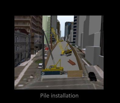


9 2 July 2013 // Page 9

10 FURTHER DEVELOPMENT 27. The interactive three dimensional computer model will be available for on-going enhancements and revisions as more detailed information becomes available. 2 July 2013 // Page 10


11 METHODOLOGY AND LIMITATIONS VALIDATION OF METHODOLOGY 28. The methodology used to build the Visualisation is based on established model building and visualisation techniques. I have reviewed the Visualisation and DVD video with key stakeholders and contributors in order to validate the methodology. SITE VISIT 29. Nextspace has visited the Albert Street site and photographed the street and surrounding buildings in the project area. 30. The three dimensional city model of the project location has been compared to the photographs. I have used the photographs to enhance the visual accuracy of the model, as indicated in sample comparisons below (buildings in grey have subsequently been updated with photographic detail in the submitted video). 2 July 2013 // Page 11
12 CONCLUSION 31. The CRL Lower Albert Street Construction Sequence Visualisation illustrates the scale and sequence of the construction process for the underground railway based on information supplied by Auckland Transport and their advisors to the best of my ability within the time available. Simon Ferneyhough 2 July July 2013 // Page 12
13 APPENDIX 1 2 July 2013 // Page 13
 Boone County GIS has the right to inquire about and investigate the use of any requested products and deny access to anyone based on concerns relating to privacy, security, public health, public safety,
VISUALIZING THE SMART CITY 3D SPATIAL INFRASTRUCTURE GEOSMART ASIA- 30 SEP, 2015
 www.aamgroup.com VISUALIZING THE SMART CITY 3D SPATIAL INFRASTRUCTURE GEOSMART ASIA- 30 SEP, 2015 Agenda AAM What is a Smart City? Data Acquisition 3D Modelling Benefits Questions AAM AAM is a Geospatial
Geographic information for Strasbourg : from historical land register to 3D GIS city modelling 09/07/2017
 Geographic information for Strasbourg : from historical land register to 3D GIS city modelling 09/07/2017 Table of contents 1. Introduction of Strasbourg 2. A century of land surveying and cadastre 3.
VISUALISATION AS A TOOL TO GUIDE STREET TREE PLANTING FOR OPTIMAL BENEFIT GAIN
 VISUALISATION AS A TOOL TO GUIDE STREET TREE PLANTING FOR OPTIMAL BENEFIT GAIN Dr Ana Macias PhD Forestry Engineer, Arbocity, Spain Co-author: Kieron J. Doick 1. Introduction 2. Methodology 3. Results
A Map Through Time Virtual Historic Cities
 A Map Through Time Virtual Historic Cities NEW WAYS OF EXPLORING DIGITAL COLLECTIONS FLORIDA INTERNATIONAL UNIVERSITY JAMIE ROGERS Coral Gables Virtual Historic City & Unearthing St. Augustine s Colonial
Martin MENSA, Eli SABLAH, Emmanuel AMAMOO-OTCHERE and Foster MENSAH, Ghana. Key words: Feeder Roads Condition Survey, Database Development
 Digital Mapping and GIS-Driven Feeder Road Network Database Management System for Road Project Planning and Implementation Monitoring in the Feeder Road Sector Martin MENSA, Eli SABLAH, Emmanuel AMAMOO-OTCHERE
Model Setup IDM Vol 2: Process Model
 Model Setup IDM Vol 2: Process Model Gateway to Melbourne, Australia. Source: Fender Katsalidis, Architects Version 1.4 27 June 2017 Contents Model Setup Exchange Scenarios... 1 Overview... 1 Project Roles...
STATEMENT OF EVIDENCE OF FIONA FORREST
 Resource Consent Applications under the Resource Management Act 1991 an application to discharge contaminants (including odour) into the air from the Roto-o-Rangi piggery at 30 Kairangi Road, Roto-o-Rangi
BEFORE THE ENVIRONMENTAL PROTECTION AUTHORITY AT WELLINGTON
 BEFORE THE ENVIRONMENTAL PROTECTION AUTHORITY AT WELLINGTON IN THE MATTER of the Exclusive Economic Zone and Continental Shelf (Environmental Effects) Act 2012 (EEZ Act) AND IN THE MATTER BETWEEN AND AND
GIS in Planning, Engineering and Environmental Applications
 GIS in Planning, Engineering and Environmental Applications Herman Ng & Eric Yau November 24, 2010 GIS for Planning Herman Ng How GIS can be made useful to Planning? GIS for Planning Herman Ng Planning
STATEMENT OF EVIDENCE OF SHANE LANDER (GEOTECHNICAL - QD2) ON BEHALF OF MURPHYS DEVELOPMENTS LIMITED
 ON BEHALF OF MURPHYS DEVELOPMENTS LIMITED") IN THE MATTER of the Housing Accords and Special Housing Areas Act 2013 ("HASHAA") AND IN THE MATTER of Proposed Qualifying Development Application ("QD2") for 125 Murphys Road, Flat Bush BETWEEN Murphys
IN THE MATTER of the Housing Accords and Special Housing Areas Act 2013 ("HASHAA") AND IN THE MATTER of Proposed Qualifying Development Application ("QD2") for 125 Murphys Road, Flat Bush BETWEEN Murphys
Blog. Infraworks 360 Model Creation Process. by David Crowther
 Page 1 of 6 Infraworks 360 Model Creation Process by David Crowther Cadline has a team of geospatial specialists with expertise in the integration of both CAD and GIS applications, and so were asked to
Airborne Corridor-Mapping. Planning and documentation of company infrastructure: precise, rapid, and cost effective
 Airborne Corridor-Mapping Planning and documentation of company infrastructure: precise, rapid, and cost effective Technology Airborne Laser-Scanning, digital orthophotos and thermal imaging: one flight
May 2011 Oracle Spatial User Conference
 May 2011 Oracle Spatial User Conference Oracle Spatial User Conference! May 19, 2011 Ronald Reagan Building and International Trade Center Washington, DC USA May 2011 Oracle Spatial User Conference Francois
The problem of rock spoil from a proposed underground nuclear waste repository in West Cumbria. David Smythe. 11 October 2011
 The problem of rock spoil from a proposed underground nuclear waste repository in West Cumbria David Smythe 11 October 2011 A letter dated May 2011 from the Nuclear Decommissioning Authority (NDA) to Cumbria
Geospatial Big Data Analytics for Road Network Safety Management
 Proceedings of the 2018 World Transport Convention Beijing, China, June 18-21, 2018 Geospatial Big Data Analytics for Road Network Safety Management ABSTRACT Wei Liu GHD Level 1, 103 Tristram Street, Hamilton,
COUNCIL POLICY MANUAL
 COUNCIL POLICY MANUAL SECTION: PUBLIC WORKS SUBJECT: SNOW & ICE CONTROL POLICY 2012/2013 GOAL: Pages: 1 of 10 Approval Date: Dec. 3, 2012 Res. # 1001/2012 To annually identify the winter maintenance costs
DATA UPDATING METHODS FOR SPATIAL DATA INFRASTRUCTURE THAT MAINTAIN INFRASTRUCTURE QUALITY AND ENABLE ITS SUSTAINABLE OPERATION
 DATA UPDATING METHODS FOR SPATIAL DATA INFRASTRUCTURE THAT MAINTAIN INFRASTRUCTURE QUALITY AND ENABLE ITS SUSTAINABLE OPERATION Saya Murakami *, Takashi Takemoto, Yutaka Ito Kokusai Kogyo Co., Ltd, 2-24-1
Illustrator: Vector base Each line/point store some sort of information Mapping Representation of the world
 Illustrator: Vector base Each line/point store some sort of information Mapping Representation of the world Photoshop Raster base Images can be overlaid Pixel vector data model: [data models] A representation
APPLICATION OF GIS IN COMPULSORY LAND ACQUISITION PROCESS. CASE STUDY: PARTS OF KAJIADO COUNTY SECTION OF THE STANDARD GAUGE RAILWAY
 APPLICATION OF GIS IN COMPULSORY LAND ACQUISITION PROCESS. CASE STUDY: PARTS OF KAJIADO COUNTY SECTION OF THE STANDARD GAUGE RAILWAY MUSYOKA SOLOMON NTHAMA F19/1456/2010 PROJECT SUPERVISOR : J.N. MWENDA
Space Syntax: Architecture and Cities MRes This programme information sheet includes details of the structure and content of the course.
 Space Syntax: Architecture and Cities MRes 2018-19 This programme information sheet includes details of the structure and content of the course. CONTENTS Overview 3 Structure 4 Content 5 Staff 6 Opportunities
Noise Maps, Report & Statistics, Dublin City Council Noise Mapping Project Roads and Traffic Department
 Noise Maps, Report & Statistics, Dublin City Council Noise Mapping Project Roads and Traffic Department Produced by Traffic Noise & Air Quality Unit November 2007 Contact: brian.mcmanus@dublincity.ie Ph;
Emergency Planning. for the. Democratic National. Convention. imaging notes // Spring 2009 //
 Emergency Planning for the Democratic National Convention The DRAPP Demonstrates Partnership among Local, Regional, State, Utility and Federal Governments 14 imaging notes // Spring 2009 // www.imagingnotes.com
1.1 What is Site Fingerprinting?
 Site Fingerprinting Utilizing GIS/GPS Technology 1.1 What is Site Fingerprinting? Site fingerprinting is a planning tool used to design communities where protection of natural resources is the primary
IN THE MATTER. of the Resource Management Act and. the Local Government. (Auckland Transitional Provisions) Act And IN THE MATTER OF
 Act And IN THE MATTER OF") IN THE MATTER of the Resource Management Act 1991 and the Local Government (Auckland Transitional Provisions) Act 2010 And IN THE MATTER OF Topic 059, 060, 062 & 063 Residential Provisions STATEMENT OF
IN THE MATTER of the Resource Management Act 1991 and the Local Government (Auckland Transitional Provisions) Act 2010 And IN THE MATTER OF Topic 059, 060, 062 & 063 Residential Provisions STATEMENT OF
Lyttelton Port Company Limited Submitter 915 / FS Statement of evidence of Neil James Charters
 Before the Independent Hearings Panel at Christchurch under: in the matter of: and: the Resource Management Act 1991 and the Canterbury Earthquake (Christchurch Replacement District Plan) Order 2014 submissions
First on the Ground. Geomatics
 First on the Ground Geomatics Surveying and mapping solutions spanning the entire project lifecycle Part art, part science, part technology, the Geomatics profession is constantly evolving. From the very
A Method for Mapping Settlement Area Boundaries in the Greater Golden Horseshoe
 A Method for Mapping Settlement Area Boundaries in the Greater Golden Horseshoe Purpose This paper describes a method for mapping and measuring the lands designated for growth and urban expansion in the
ENHANCING ROAD SAFETY MANAGEMENT WITH GIS MAPPING AND GEOSPATIAL DATABASE
 Abstract ENHANCING ROAD SAFETY MANAGEMENT WITH GIS MAPPING AND GEOSPATIAL DATABASE Dr Wei Liu GHD Reliable and accurate data are needed in each stage of road safety management in order to correctly identify
Corporate. Information. Railway Infrastructure Administrator. Year indracompany.com
 geospatial and mobility Corporate Geographic Information System of ADIF Railway Infrastructure Administrator. Year 2009-2010 Corporate Geographic Information System of ADIF ADIF. Spanish Administrator
Cities in Space and Time: A Spatial-Temporal Visualization Model of Urban Environments
 Cities in Space and Time: A Spatial-Temporal Visualization Model of Urban Environments Li Yin Assistant Professor Department of Urban and Regional Planning University at Buffalo, The State University of
Area-wide geotechnical information summary for CERA zoning review panel
 Area-wide geotechnical information summary for CERA zoning review panel This document contains all the area-wide geotechnical information which was considered by CERA as part of the process for making
Mapping a Nation in 3D Singapore s Journey. Bryan Chew Registrar of Titles Assistant Chief Executive Singapore Land Authority
 Mapping a Nation in 3D Singapore s Journey Bryan Chew Registrar of Titles Assistant Chief Executive Singapore Land Authority Singapore Size - 719 sq km Population - 5.5 million Density 7,600/sq km Singapore
Crossrail C430 Advanced Works Farringdon, London
 Crossrail C430 Advanced Works Farringdon, London Presented By: Colin Murphy Director Tel: Office: +44 (0)20 3178 6644 Mobile: +44 (0)79 4410 0891 Email: cmurphy@murphysurveys.co.uk Key Facts: Client: Laing
A. My name is Watsun Randolph and my business address is 45 Horner Street Warrenton
 DIRECT TESTIMONY OF WATSUN RANDOLPH ON BEHALF OF PIEDMONT ENVIRONMENTAL COUNCIL BEFORE THE STATE CORPORATION COMMISSION OF VIRGINIA CASE NOS. PUE-00-000 AND PUE-00-000 0 Q. PLEASE STATE YOUR NAME AND BUSINESS
Attachment 3. Updating UBC s Regional Context Statement. University of British Columbia CONSIDERATION MEMORANDUM OF CONSULTATION INPUT
 Attachment 3 University of British Columbia Updating UBC s Regional Context Statement CONSIDERATION MEMORANDUM OF CONSULTATION INPUT Campus and Community Planning February 24, 2014 1 CONSIDERATION MEMORANDUM
New Zealand King Salmon
 New Zealand King Salmon Proposed Salmon Farms Visual Simulations 16 March 2012 Prepared for New Zealand King Salmon Limited by Boffa Miskell Limited Simulation Methodology Port Gore Introduction Preparation
GEOMATICS. Shaping our world. A company of
 GEOMATICS Shaping our world A company of OUR EXPERTISE Geomatics Geomatics plays a mayor role in hydropower, land and water resources, urban development, transport & mobility, renewable energy, and infrastructure
Applications of GIS in Electrical Power System. Dr. Baqer AL-Ramadan Abdulrahman Al-Sakkaf
 Applications of GIS in Electrical Power System Dr. Baqer AL-Ramadan Abdulrahman Al-Sakkaf OUTLINES: Objective Importance of GIS GIS data development Application of GIS Findings Conclusions and Recommendations
SOLUTIONS ADVANCED GIS. TekMindz are developing innovative solutions that integrate geographic information with niche business applications.
 ADVANCED GIS SOLUTIONS TekMindz are developing innovative solutions that integrate geographic information with niche business applications. TEK INDZ TM GIS Services Overview At the leading edge of geospatial
Virtual 3D Cities. Chapter VIII. Virtual 3D Cities. 8.1 Introduction. Components. Chapter VIII: Virtual 3D Cities 1
 Chapter VIII Virtual 3D Cities 8.1 Introduction 8.2 CityGML 8.3 Google Earth 8.4 Virtual Earth 8.5 Conclusions Virtual 3D Cities 8.1 Introduction 3D Visualization of cities Languages such as CityGML New
Study on Shandong Expressway Network Planning Based on Highway Transportation System
 Study on Shandong Expressway Network Planning Based on Highway Transportation System Fei Peng a, Yimeng Wang b and Chengjun Shi c School of Automobile, Changan University, Xian 71000, China; apengfei0799@163.com,
THE SPATIAL DATA WAREHOUSE OF SEOUL
 THE SPATIAL DATA WAREHOUSE OF SEOUL Jae-Ho Han The Seoul Metropolitan Government Seoul City Hall, Taepyeongno 1(il)-ga, Jung-gu, Seoul 100-744, Korea djhjha@hanmail.net Impyeong Lee Dept. of Geoinformatics,
Chapter 1 Overview of Maps
 Chapter 1 Overview of Maps In this chapter you will learn about: Key points when working with maps General types of maps Incident specific maps Map legend and symbols Map sources A map is a navigational
Land Administration and Cadastre
 Geomatics play a major role in hydropower, land and water resources and other infrastructure projects. Lahmeyer International s (LI) worldwide projects require a wide range of approaches to the integration
Exploit your geodata to enable smart cities and countries
 Exploit your geodata to enable smart cities and countries Carsten Rönsdorf, Head of Advisory Services Middle East Practice Manager Future Cities, standards and 3D 24 November 2014 Importance of Standards
Accessibility analysis of multimodal transport systems using advanced GIS techniques
 Urban Transport XIII: Urban Transport and the Environment in the 21st Century 655 Accessibility analysis of multimodal transport systems using advanced GIS techniques T. Vorraa Citilabs Regional Director,
Graphic Attachment 2 Photo-simulations PROPOSED DAIRY PLANT EXPANSION - STUDHOLME
 Graphic Attachment 2 Photo-simulations PROPOSED DAIRY PLANT EXPANSION - STUDHOLME 1 Methodology for Preparation of Photo Simulations 1 The main objective of a photo simulation is to provide an image that,
Urban Spatial Scenario Design Modelling (USSDM) in Dar es Salaam: Background Information
 in Dar es Salaam: Background Information") Urban Spatial Scenario Design Modelling (USSDM) in Dar es Salaam: Background Information Modelling urban settlement dynamics in Dar es Salaam Revision: 2 (July 2013) Prepared by: Katja Buchta TUM team
Urban Spatial Scenario Design Modelling (USSDM) in Dar es Salaam: Background Information Modelling urban settlement dynamics in Dar es Salaam Revision: 2 (July 2013) Prepared by: Katja Buchta TUM team
GEOMATICS SURVEYING AND MAPPING EXPERTS FOR OVER 35 YEARS
 GEOMATICS SURVEYING AND MAPPING EXPERTS FOR OVER 35 YEARS 2 GEOMATICS AND SURVEYING SOLUTIONS SPANNING THE ENTIRE PROJECT LIFECYCLE 1,000+ 250+ 24 Surveying professionals Active field crews Geomatics offices
geographic patterns and processes are captured and represented using computer technologies
 Proposed Certificate in Geographic Information Science Department of Geographical and Sustainability Sciences Submitted: November 9, 2016 Geographic information systems (GIS) capture the complex spatial
An online data and consulting resource of THE UNIVERSITY OF TOLEDO THE JACK FORD URBAN AFFAIRS CENTER
 An online data and consulting resource of THE JACK FORD URBAN AFFAIRS CENTER THE CENTER FOR GEOGRAPHIC INFORMATION SCIENCE AND APPLIED GEOGRAPHICS DEPARTMENT OF GEOGRAPHY AND PLANNING THE UNIVERSITY OF
REVISED UPDATED PREPARED DIRECT SAFETY ENHANCEMENT COST ALLOCATION TESTIMONY OF GARY LENART SAN DIEGO GAS & ELECTRIC COMPANY AND
 Application No: Exhibit No.: Witness: A.--00 ) In the Matter of the Application of San Diego Gas & ) Electric Company (U 0 G) and Southern California ) Gas Company (U 0 G) for Authority to Revise ) Their
Explore. history landscapes family.
 Explore history landscapes family www.explorethepast.co.uk Contents From the team Section 1 Researching Worcestershire Section 2 Local Studies & Archaeology Reference Library Section 3 Maps and plans Accessing
Map Name(s) and Date(s) Russian Map - Slice A. Order Details. Site Details Wilton Site, Middlesbrough, Cleveland, TS8 9JA
 and Date(s) Russian Map - Slice A. Order Details. Site Details Wilton Site, Middlesbrough, Cleveland, TS8 9JA") Middlesbrough Published 1991 Source map scale - 1:25,000 These maps were produced by the Russian military during the Cold War between 1950 and 1997, and cover 103 towns and cities throughout the U.K. The
Middlesbrough Published 1991 Source map scale - 1:25,000 These maps were produced by the Russian military during the Cold War between 1950 and 1997, and cover 103 towns and cities throughout the U.K. The
A new type of RICEPOTS
 A new type of RICEPOTS Alan Parkinson Geography teaching resource College Crown Copyright and Database Right 2014. Ordnance Survey (Digimap Licence) This is one of a series of teaching resources for use
Proposed Scope of Work Village of Farmingdale Downtown Farmingdale BOA Step 2 BOA Nomination Study / Draft Generic Environmental Impact Statement
 Proposed Scope of Work Village of Farmingdale Downtown Farmingdale BOA Step 2 BOA Nomination Study / Draft Generic Environmental Impact Statement The scope of work that follows incorporates and covers
Coastal Hazard and Climate-Change Risk Exposure in New Zealand: Comparing Regions and Urban Areas
 Presented at the FIG Working Week 2016, May 2-6, 2016 in Christchurch, New Zealand Coastal Hazard and Climate-Change Risk Exposure in New Zealand: Comparing Regions and Urban Areas Rob Bell, Ryan Paulik
Empowering water/wastewater network management with GIS
 Empowering water/wastewater network management with GIS Ioannis Kavouras_GIS Manager Surveying Engineer, MSc, MBA The Company responsible for fresh water distribution & sanitation serving 1.500.000 citizens
Legal problems of environmental management. Spatial planning and space management. M. Gajewski 2014 / 2015
 Legal problems of environmental management Spatial planning and space management M. Gajewski 2014 / 2015 Course contents (in brief) Constitutional basis of the environment protection system. General principles
Process Simplification Office of the Vice President for Management and Budget. University Mapping Implementation Team (UMapIT) Final Report
 Final Report") Process Simplification Office of the Vice President for Management and Budget University Mapping Implementation Team (UMapIT) Final Report Table of Contents Introduction...3 Definitions...3 UMI Recommendations...3
Process Simplification Office of the Vice President for Management and Budget University Mapping Implementation Team (UMapIT) Final Report Table of Contents Introduction...3 Definitions...3 UMI Recommendations...3
The following maps must be provided as a part of the ADA. The appropriate scale for each map should be determined at the pre application conference.
 Main Street @ Coconut Creek DRI QUESTION 9 MAPS The following maps must be provided as a part of the ADA. The appropriate scale for each map should be determined at the pre application conference. Map
National Onshore Gas Pipelines Database Metadata Statement
 National Onshore Gas Pipelines Database Metadata Statement Last updated in 2014 Use Constraint: Geocat Number: 82579 Commonwealth of Australia (Geoscience Australia) 2014 This material is released under
High Speed / Commuter Rail Suitability Analysis For Central And Southern Arizona
 High Speed / Commuter Rail Suitability Analysis For Central And Southern Arizona Item Type Reports (Electronic) Authors Deveney, Matthew R. Publisher The University of Arizona. Rights Copyright is held
Module 4 Educator s Guide Overview
 Module 4 Educator s Guide Overview Paths Module Overview This module looks at many different kinds of paths and considers why paths are where they are and how they look from space. Paths are usually not
Area-wide geotechnical information summary for CERA zoning review panel
 Area-wide geotechnical information summary for CERA zoning review panel This document contains all the area-wide geotechnical information which was considered by CERA as part of the process for making
Level 1 Geography, 2017
 91007 910070 1SUPERVISOR S Level 1 Geography, 2017 91007 Demonstrate geographic understanding of environments that have been shaped by extreme natural event(s) 9.30 a.m. Thursday 23 November 2017 Credits:
FIRST PASS METHODOLOGY OF CITYWIDE FLOOD INUNDATION MAPPING
 FIRST PASS METHODOLOGY OF CITYWIDE FLOOD INUNDATION MAPPING R. VanDrie 1 *, M. Simon 2 1 Shellharbour City Council, PO Box 155, Shellharbour City Centre, 2529 NSW, Australia e-mail rudy.vandrie@shellharbour.nsw.gov.au
KETCHUM ARTS COMMISSION INTERACTIVE ART CALL FOR ARTISTS Request for Qualifications
 KETCHUM ARTS COMMISSION INTERACTIVE ART CALL FOR ARTISTS Request for Qualifications I N T R O D U C T I O N The City of Ketchum, Idaho, invites professional artists, architects or designers to apply for
Interactive Visualization Tool (InViTo)
") Interactive Visualization Tool (InViTo) Stefano Pensa To cite this report: Stefano Pensa (2012) Interactive Visualization Tool (InViTo), in Angela Hull, Cecília Silva and Luca Bertolini (Eds.) Accessibility
Interactive Visualization Tool (InViTo) Stefano Pensa To cite this report: Stefano Pensa (2012) Interactive Visualization Tool (InViTo), in Angela Hull, Cecília Silva and Luca Bertolini (Eds.) Accessibility
CLAREMONT MASTER PLAN 2017: LAND USE COMMUNITY INPUT
 Planning and Development Department 14 North Street Claremont, New Hampshire 03743 Ph: (603) 542-7008 Fax: (603) 542-7033 Email: cityplanner@claremontnh.com www.claremontnh.com CLAREMONT MASTER PLAN 2017:
STEREO ANALYST FOR ERDAS IMAGINE Stereo Feature Collection for the GIS Professional
 STEREO ANALYST FOR ERDAS IMAGINE Stereo Feature Collection for the GIS Professional STEREO ANALYST FOR ERDAS IMAGINE Has Your GIS Gone Flat? Hexagon Geospatial takes three-dimensional geographic imaging
Russian Military Mapping Legends
 Russian Military Mapping Legends 1:5,000 and 1:10,000 mapping 1:25,000 mapping Key to Numbers on Mapping Historical Mapping & Photography included: NZ52_Middlesbrough No. Description 52 Factories (Chemicals)
Ethiopia: Transport Systems Improvement Project (TRANSIP) (P151819)
 (P151819)") Public Disclosure Authorized AFRICA Ethiopia Transport & Digital Development Global Practice IBRD/IDA Investment Project Financing FY 2016 Seq No: 5 ARCHIVED on 23-Nov-2018 ISR34538 Implementing Agencies:
Public Disclosure Authorized AFRICA Ethiopia Transport & Digital Development Global Practice IBRD/IDA Investment Project Financing FY 2016 Seq No: 5 ARCHIVED on 23-Nov-2018 ISR34538 Implementing Agencies:
Module 3 Educator s Guide Overview
 Module 3 Educator s Guide Overview Human footprints on Earth as seen by NASA scientists Module Overview This module draws upon NASA images and research to introduce students to the various ways humans
Write a report (6-7 pages, double space) on some examples of Internet Applications. You can choose only ONE of the following application areas:
 on some examples of Internet Applications. You can choose only ONE of the following application areas:") UPR 6905 Internet GIS Homework 1 Yong Hong Guo September 9, 2008 Write a report (6-7 pages, double space) on some examples of Internet Applications. You can choose only ONE of the following application
UPR 6905 Internet GIS Homework 1 Yong Hong Guo September 9, 2008 Write a report (6-7 pages, double space) on some examples of Internet Applications. You can choose only ONE of the following application
Base Maps: Creating, Using & Participating
 Base Maps: Creating, Using & Participating Michael Fashoway & Erin Geraghty Montana Base Map Service Center 2010 MAGIP Technical Session October 28, 2010 What is a Base Map? Using a Base Map Creating a
Go to contents 17 Figure 1. Diagram of the system prototype framework
 GIS-based Visual Perception Analysis of Urban Natural Landscape for Urban Planning Supporting: A Case Study of Jinzishan Hill Region HE, Jie; TSOU, Jinyeu Tsou Department of Architecture, The Chinese University
INSPIRE in the context of EC Directive 2002/49/EC on Environmental Noise
 INSPIRE in the context of EC Directive 2002/49/EC on Environmental Noise Simon Shilton Acustica Ltd, United Kingdom Nigel Jones Extrium Ltd, United Kingdom About the Authors www.acustica.co.uk Acoustics
The Road to Data in Baltimore
 Creating a parcel level database from high resolution imagery By Austin Troy and Weiqi Zhou University of Vermont, Rubenstein School of Natural Resources State and local planning agencies are increasingly
The use of Geographic Information Systems (GIS) in Electrification
 in Electrification") The use of Geographic Information Systems (GIS) in Electrification S lindi Mhlongo, GIS Advisor, Eskom, South Africa About this Presentation Introduction About Eskom Who is GIS What is GIS GIS in Electrification
The use of Geographic Information Systems (GIS) in Electrification S lindi Mhlongo, GIS Advisor, Eskom, South Africa About this Presentation Introduction About Eskom Who is GIS What is GIS GIS in Electrification
Flood Hazard Zone Modeling for Regulation Development
 Flood Hazard Zone Modeling for Regulation Development By Greg Lang and Jared Erickson Pierce County GIS June 2003 Abstract The desire to blend current digital information with government permitting procedures,
NOISE IMPACT ASSESSMENT 114 ISABELLA STREET RESIDENTIAL DEVELOPMENT OTTAWA, ONTARIO
 Smart Property Advisors Ltd. 802-500 Laurier Avenue West Ottawa, ON NOISE IMPACT ASSESSMENT 114 ISABELLA STREET RESIDENTIAL DEVELOPMENT OTTAWA, ONTARIO Prepared by: SMART PROPERTY ADVISORS LTD. 802 500
Demand Forecasting. for. Microsoft Dynamics 365 for Operations. User Guide. Release 7.1. April 2018
 Demand Forecasting for Microsoft Dynamics 365 for Operations User Guide Release 7.1 April 2018 2018 Farsight Solutions Limited All Rights Reserved. Portions copyright Business Forecast Systems, Inc. This
Parking Regulations Dundas Street West, from Bathurst Street to Dovercourt Road
 STAFF REPORT ACTION REQUIRED Parking Regulations Dundas Street West, from Bathurst Street to Dovercourt Road Date: October 28, 2008 To: From: Toronto and East York Community Council Director, Transportation
AUCKLAND MOTORWAY EXTENSION NORTHLAND REGION, NEW ZEALAND
 LEAPFROG WORKS 1 CASE STUDY Case Study: Tonkin & Taylor and Beca Design JV Puhoi to Warkworth motorway AUCKLAND MOTORWAY EXTENSION NORTHLAND REGION, NEW ZEALAND 2 The 3D subsurface model encompasses the
Measuring connectivity in London
 Measuring connectivity in London OECD, Paris 30 th October 2017 Simon Cooper TfL City Planning 1 Overview TfL Connectivity measures in TfL PTALs Travel time mapping Catchment analysis WebCAT Current and
of the Resource Management Act 1991 ("Act") (ENV-2013-AKL )
 (ENV-2013-AKL )") BEFORE THE ENVIRONMENT COURT IN THE MATTER of the Resource Management Act 1991 ("Act") AND IN THE MATTER of a Notice of Motion under section 87G of the Act requesting the granting of resource consents
BEFORE THE ENVIRONMENT COURT IN THE MATTER of the Resource Management Act 1991 ("Act") AND IN THE MATTER of a Notice of Motion under section 87G of the Act requesting the granting of resource consents
Surveyors, Cartographers, Photogrammetrists, and Surveying and Mapping Technicians
 http://www.bls.gov/oco/ocos040.htm Surveyors, Cartographers, Photogrammetrists, and Surveying and Mapping Technicians * Nature of the Work * Training, Other Qualifications, and Advancement * Employment
Unit 1, Lesson 3 What Tools and Technologies Do Geographers Use?
 Unit 1, Lesson 3 What Tools and Technologies Do Geographers Use? Geographers use a variety of tools and technologies in investigating geographic questions. Maps and globes both represent the earth, but
Directive on the Assessment and Management of Environmental Noise
 Directive on the Assessment and Management of Environmental Noise This Directive has been ratified by the European Parliament and is awaiting publication in the Official Journal.( around 23/5/02) The Directive
inovitas be on site with infra3d
 inovitas be on site with infra3d be inspired... Infrastructure has an immense property value and is a prerequisite for a functioning competitive economy. In this context, the modes of transport such as
The demand for housing as
 Using GIS for optimisation of service delivery by Nthabiseng Motsamai and Chris Munyati, North West University The location of settlements has an important bearing on the effectiveness and feasibility
Providing Public Access to King County GIS Data. Presented by: Michael Jenkins King County GIS Center Seattle, WA
 Providing Public Access to King County GIS Data Presented by: Michael Jenkins King County GIS Center Seattle, WA King County, Washington Microsoft Boeing Amazon.Com Starbucks Port of Seattle Weyerhauser
Date: June 19, 2013 Meeting Date: July 5, Consideration of the City of Vancouver s Regional Context Statement
 Section E 1.5 To: From: Regional Planning and Agriculture Committee Lee-Ann Garnett, Senior Regional Planner Planning, Policy and Environment Department Date: June 19, 2013 Meeting Date: July 5, 2013 Subject:
Why care about metropolitan and regional perspectives?
 Metropolitan challenges and solutions Why care about metropolitan and regional perspectives? Irma Karjalainen, Director, Helsinki Region Environmental Services Authority HSY, LUMAT Conference, 25 September
Smart Solutions for Spatial Planning
 Smart Solutions for Spatial Planning Aedas R&D [Computational Design Research] Centre for Evolutionary Computing in Architecture [CECA @ UEL] Knowledge Transfer [breaking silos] * constructing consensus
RESOLUTION NO
 RESOLUTION NO. 09-2017 Adopting Job Descriptions for Engineering and GIS Manager and GIS Analyst and Amending the Pay Resolution to Accommodate Said Positions and Amending the Staffing Chart to Accommodate
Implementing ArcGis 10 infrastructure to resolve mining problems
 Implementing ArcGis 10 infrastructure to resolve mining problems ESRI UC 2013, San Diego, 8-12 July, 2013 A R T U R O M O R A L E S L A D R O N D E G U E V A R A, E L T E N I E N T E M I N E, C O D E L
Unit 1, Lesson 2. What is geographic inquiry?
 What is geographic inquiry? Unit 1, Lesson 2 Understanding the way in which social scientists investigate problems will help you conduct your own investigations about problems or issues facing your community