STATEMENT OF EVIDENCE OF SHANE LANDER (GEOTECHNICAL - QD2) ON BEHALF OF MURPHYS DEVELOPMENTS LIMITED
|
|
|
- Silvia Willis
- 6 years ago
- Views:
Transcription
 AND Auckland Council STATEMENT OF EVIDENCE OF SHANE LANDER (GEOTECHNICAL - QD2) ON BEHALF OF MURPHYS DEVELOPMENTS LIMITED 11 NOVEMBER")
1 IN THE MATTER of the Housing Accords and Special Housing Areas Act 2013 ("HASHAA") AND IN THE MATTER of Proposed Qualifying Development Application ("QD2") for 125 Murphys Road, Flat Bush BETWEEN Murphys Developments Limited ("the applicant") AND Auckland Council STATEMENT OF EVIDENCE OF SHANE LANDER (GEOTECHNICAL - QD2) ON BEHALF OF MURPHYS DEVELOPMENTS LIMITED 11 NOVEMBER 2015
2 1. Introduction, Qualifications and Experience 1.1 My full name is Shane Gareth Lander. I hold a Bachelor of Engineering from Auckland University (1998) and a New Zealand Certificate of Engineering (Civil) from Carrington Polytechnic (1995). I am a member of the Institute of Profession Engineers New Zealand (MIPENZ), a Chartered Professional Engineer (CPEng) and am on the register of International Professional Engineers New Zealand (Int.PE(NZ)). I have practised as a professional geotechnical engineer in the following capacities: 1.2 I have 20 years experience undertaking professional geotechnical engineering assessments, construction observations and compliance documentation for clients in both the public and private sectors on a wide variety of minor to major projects within a range of geological settings. This has included hundreds of lots in the in the Southern Landslide Zone geology of Tuscany Estates residential development to the east of the study area, and similarly many substantial subdivisions and building developments to the north within the alluvial lowlands of Flat Bush, including the proposed Ormiston Town Centre, and associated infrastructure and stormwater treatment / attenuation ponds. 2. Code of Conduct 2.1 I confirm that I have read the Code of Conduct for Expert Witnesses contained in the Environment Court Practice Note 2014 and that I agree to comply with it. I confirm that, unless I state otherwise, I have considered all material facts that I am aware of that might alter or detract from the opinion that I express, and that the evidence is within my area of expertise. Geotechnical Evidence QD2 Page 2
3 3. Scope of Evidence 3.1 I have prepared three geotechnical reports for the study area, the first being a desktop study on some properties south of 125 Murphys Road (Ref J00039) dated 25 February 2015, the second being supplementary geotechnical advice dated 14 March 2015 (Ref J00039) pertaining to the Plan Variation, and the last being a comprehensive geotechnical investigation report (GIR) on 6 May 2015 (Ref J00016) addressing the first stage Qualifying Development at 125 Murphys Road. I have also provided an addendum memorandum to the latter report dated 4 August My evidence outlines the key findings of those reports, and then provides focus on the proposed road embankment. 3.2 My evidence is structured as follows: 4. Summary of Key Conclusions 4.1 Two different geological units exist in the study area, these being Tauranga Group alluvium and East Coast Bays Formation sedimentary lithology. 4.2 The study area comprises topography and ground conditions that are typical of other regions of the Flat Bush area. There are existing geotechnical reports relating to the study area and as such, ground conditions and geotechnical issues are reasonably well understood by me. 4.3 The proposed road embankment crossing will comprise engineer compacted GAP65 hardfill, with box culvert beneath and be supported by an engineer designed gabion retaining walls. There is an existing Vector gas line approximately 4m from the toe of the northern retaining wall. 4.4 It is apparent from my 6 March 2015 report that transition to bedrock deposits will be present within approximately 1.5m of the existing ground surface. 4.5 I have concluded that the road embankment can be safely constructed as proposed, provided the base of the retaining walls found upon the transition to bedrock materials at or below the invert level of the gas main. In doing so, I consider that the structure will not have adverse geotechnical effects to prevailing site conditions and loads will not be adversely transferred onto the gas main to the north. Geotechnical Evidence QD2 Page 3
4 5. Summary of Geological Setting 5.1 The study area is bounded by Murphys Road to the west and farmland to the north and east. The study area is mostly in pasture and is characterised by a branched tributary gully systems which becomes single as it approaches the northern boundary. The land either side of the gully systems is broadly undulating. Numerous service lines / utilities traverse the land in the vicinity of the qualifying development. 5.2 Two different geological units exist in the study area. The lower (northern) reaches of the site contains Tauranga Group alluvium, while the more elevated (central and southern) portions contain East Coast Bays Formation of the Waitemata Group sedimentary lithology. The elevated southwestern portion of the site falls within a large and significant area known as the Southern Landslide Zone, which generally defines the steeper ground of the Manukau Heights, Brookby and Whitford regions. 5.3 The site geomorphology is typical of this portion of the Flat Bush area and is characterised by moderately steep slopes that fall to the north, north-west and north-east. The flanks encompassing the gullies typically contain steep slopes (exceeding 1(v):4(h)), and these show signs of active soil creep and relic shallow seated slope failure. The general topography of the landform either side (remote from) the gully systems appears smooth with no obvious signs of past or recent slope movement. 6. Summary of Geotechnical Reports Desktop Study on Some Properties South of 125 Murphys Road dated 25 February My desktop report provided a summary of geological ground conditions with regard to the properties numbered 51, 57, 53, 67, 71, 75 and 79 Murphys Road; all located south of number 125 Murphys Road. 6.2 I recommended that comprehensive geotechnical investigations conducted by a Chartered Geotechnical Engineer would need to be undertaken on the aforementioned properties to identify the mechanisms of slope failure on the gully margins, and to confirm the existing ground conditions are congruent with accepted geotechnical ground models. 6.3 I concluded that such geotechnical risks can be eliminated or mitigated during earthworks design and in doing so, the land may be considered suitable for re-zoning to future urban use. Geotechnical Evidence QD2 Page 4
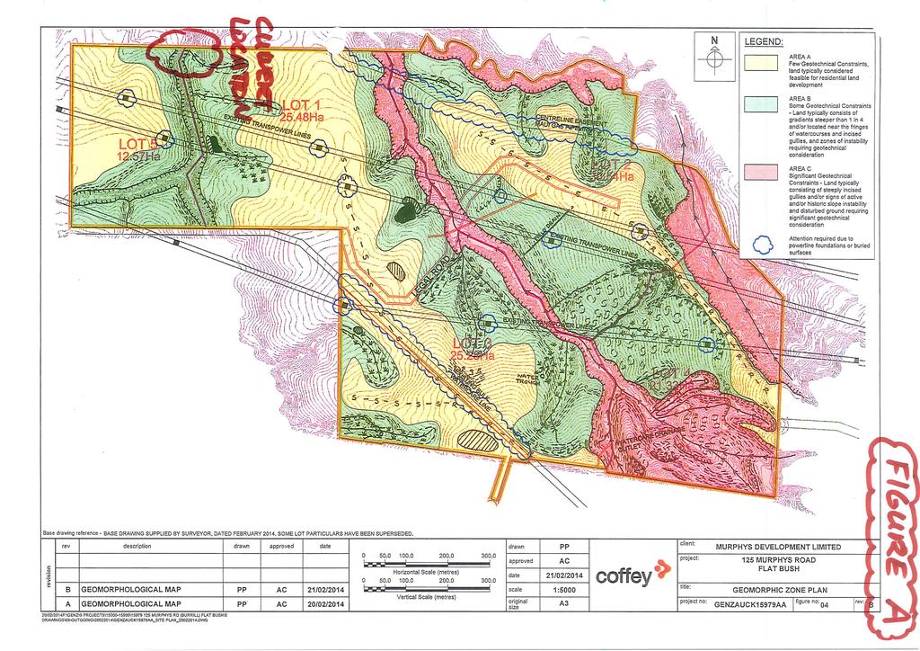
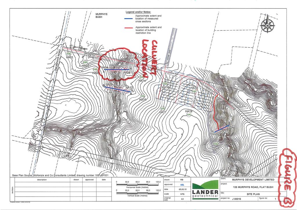
5 Supplementary Advice for the Plan Variation dated 14 March I was asked to review the Coffey Geotechnics (NZ) Limited Preliminary Appraisal Report dated 4 December 2014 which encompasses the study area, and the Auckland Council Plan Variation Application dated 9 February Specifically, Council stated The proposed plan variation seeks to provide zoning for urban development across the entire SHA area with relatively intense forms of development possible. The [Coffey] geotechnical appraisal for 125 Murphys Road identified that some areas of land, identified as Area C has significant geotechnical constraints and page 28 under sub heading Risks from natural hazard state, Area C is likely to be vested as green corridor zone the zoning as applied needs to be updated to reflect this 6.6 My 14 March 2015 response expressed that substantial portions of Area C may be modified and refined by geotechnical and engineering input that will allow development alongside green corridors, as is consistent with other developments in Flat Bush to date. In my experience this is addressed during subsequent subdivision design phases. 6.7 I have attached a site plan (annotated by me as Figure A) in Attachment 1 to this evidence, depicting the extent of Area C. Geotechnical Investigation Report (GIR) the First Stage Qualifying Development dated 6 May This report presented the results of a comprehensive site investigation across the northern extent of the study area, involving the drilling of 23 boreholes, cross sectional measurements and slope stability analyses. 6.9 I concluded in this report that provided specific recommendations I made were heeded, then the land was in my view geotechnically suitable for the proposed first stage Qualifying Development I have attached a site plan (annotated as Figure B) depicting the extent of the investigations made here. Addendum Memorandum to GIR dated 4 August I prepared a technical memorandum on 4 August 2015 relating to the proposed embankment comprising a gravity retaining wall system at Park Edge Road chainage 280m, with respect to its proximity to a gas main located approximately 4m to the north. I intended that this memo was to be read in conjunction with the overarching GIR I have just described. Geotechnical Evidence QD2 Page 5
6 6.12 Based on the GIR data, I inferred that hard transition to bedrock materials would be near to the surface (within 1.5m in places) and concluded that provided the foundations for the retaining wall system founded into the those materials, and that the invert of the gravity wall system was embedded at or below the invert level of the gas main, then vertical foundation loads associated with the embankment should not be transmitted onto the gas main. 7. The Proposed Road Embankment Key Geotechnical Considerations 7.1 The proposed road embankment across the stream requires the construction of a road retained on either side by gabion basket retaining walls up to a height of approximately 9.7m on the northern side and 7.1m on the southern side. 7.2 The gabion baskets will support geogrid reinforced GAP65 hardfill forming the road embankment. Three (2m wide) box culverts will transmit waterflows through the embankment in a south to north fashion. 7.3 I have annotated onto attached Figures A and B (refer to Attachment 1) the approximate location of the culvert, which is the site of the road embankment. 7.4 You will note on Figure B that boreholes 4 to 8 and cross section A-A from the GIR are relevant to this road embankment. Accordingly, I have attached (Figure C) geotechnical cross section A-A through this area to illustrate the ground model and location of the transition to bedrock materials I have mentioned above. 7.5 As noted in my summary of the Addendum Memorandum of 4 August 2015, I am satisfied that if the foundations for the engineer designed gabion walls are located within the transition to bedrock materials and found below the invert level of the gas main where it is located 4m to the north, then the embankment will be geotechnically fit for purpose and mitigate risk to the gas main. 8. Council Officers Section 42A Report 8.1 I have reviewed the Council planner's section 42A report prepared for the Council hearing. 8.2 I note on page 84 that consent notices may be required for geotechnical matters, and that a geotechnical completion report is required for 224C application, however there is nothing unusual about this in my experience. 8.3 I note on page 85 that Auckland Transport recommends conditions in terms of the detailed design and construction methodology for the culvert crossing and road embankment. I consider my evidence addresses some fundamental geotechnical foundation aspects for the embankment, culvert and retaining walls in this regard. Geotechnical Evidence QD2 Page 6
7 8.4 To the best of my knowledge there is nothing else raised in the planner s report that requires my further comment. 9. Conclusions 9.1 I have concluded that if the foundations for the engineer designed gabion walls are located within the transition to bedrock materials and found below the invert level of the gas main, where it is located 4m to the north, then the embankment (that is adequately designed, expertly constructed and documented by appropriate engineering observations and testing) will be geotechnically fit for purpose and mitigate risk to the gas main to the north. Shane Lander 11 November 2015 Geotechnical Evidence QD2 Page 7
8 ATTACHMENT 1 Figures A, B and C
9
10
11
Geotechnical Completion Report Knights Stream Park Stage3A Development (Lots 107 to 148)
") Aurecon New Zealand Limited Unit 1, 150 Cavendish Road Casebrook Christchurch 8051 PO Box 1061 Christchurch 8140 New Zealand T F E W +64 3 366 0821 +64 3 379 6955 christchurch@aurecongroup.com aurecongroup.com
Aurecon New Zealand Limited Unit 1, 150 Cavendish Road Casebrook Christchurch 8051 PO Box 1061 Christchurch 8140 New Zealand T F E W +64 3 366 0821 +64 3 379 6955 christchurch@aurecongroup.com aurecongroup.com
Lyttelton Port Company Limited Submitter 915 / FS Statement of evidence of Neil James Charters
 Before the Independent Hearings Panel at Christchurch under: in the matter of: and: the Resource Management Act 1991 and the Canterbury Earthquake (Christchurch Replacement District Plan) Order 2014 submissions
Natural hazards in Glenorchy Summary Report May 2010
 Natural hazards in Glenorchy Summary Report May 2010 Contents Glenorchy s hazardscape Environment setting Flood hazard Earthquakes and seismic hazards Hazards Mass movement Summary Glossary Introduction
DRAFT. PRELIMINARY LANDSLIDE MODELING for KRAMER AVENUE LANDSLIDE SITKA, ALASKA. Prepared for: Andrew Friske 210 Kramer Ave. Sitka, Alaska 99835
 PRELIMINARY LANDSLIDE MODELING for KRAMER AVENUE LANDSLIDE SITKA, ALASKA Prepared for: Andrew Friske 210 Kramer Ave. Sitka, Alaska 99835 Prepared by: Northern Geotechnical Engineering, Inc. d.b.a. Terra
Milford Centre Ltd. Private Plan Change GEOTECHNICAL ASSESSMENT
 Milford Centre Ltd. Private Plan Change GEOTECHNICAL ASSESSMENT Final 15 April 2008 Milford Centre Ltd. Private Plan Change GEOTECHNICAL ASSESSMENT Final 15 April 2008 Sinclair Knight Merz 25 Teed Street
GEOTECHNICAL ENGINEERING II. Subject Code : 06CV64 Internal Assessment Marks : 25 PART A UNIT 1
 GEOTECHNICAL ENGINEERING II Subject Code : 06CV64 Internal Assessment Marks : 25 PART A UNIT 1 1. SUBSURFACE EXPLORATION 1.1 Importance, Exploration Program 1.2 Methods of exploration, Boring, Sounding
Impact : Changes to Existing Topography (Less than Significant)
") 4.2 Land Resources 4.2.1 Alternative A Proposed Action Impact 4.2.1-1: Changes to Existing Topography (Less than Significant) Development of the project site would involve grading and other earthwork as
4.2 Land Resources 4.2.1 Alternative A Proposed Action Impact 4.2.1-1: Changes to Existing Topography (Less than Significant) Development of the project site would involve grading and other earthwork as
GUIDANCE D. Part D: Guidelines for the geotechnical investigation and assessment of subdivisions in the Canterbury region.
 GUIDANCE D CONTENTS Part D: Guidelines for the geotechnical investigation and assessment of subdivisions in the Canterbury region Minimum requirements for geotechnical assessment for land development (
TODAY - March 20, 2000
 information subject to this section and Sections 40(1) and 40(2) of DAO 92-29, shall be done only in cases allowed under Section 40(3) SECTION 9. FINES AND PENALTIES. Any person, natural or juridical,
16 January 2018 Job Number: RICHARD NEWMAN C\- CLARK FORTUNE MCDONALD AND ASSOCIATES PO BOX 553 QUEENSTOWN
 16 January 2018 Job Number: 50595 RICHARD NEWMAN C\- CLARK FORTUNE MCDONALD AND ASSOCIATES PO BOX 553 QUEENSTOWN CHANSEN@CFMA.CO.NZ STORMWATER DISPOSAL ASSESSMENT Dear Richard, RDAgritech were requested
Re: Steep Slope Assessment for 2465 Waverly Drive, Blind Bay, BC; Legal Address: Lot 39, Section 18, Township 22, Range 10, Plan 25579, W6M, KDYD.
 OEL File 1563-1 May 30, 2017 Doug Wall PO Box 774 Salmon Arm, BC V1E 4N7 Re: Steep Slope Assessment for 2465 Waverly Drive, Blind Bay, BC; Legal Address: Lot 39, Section 18, Township 22, Range 10, Plan
Hawke s Bay Liquefaction Hazard Report - Frequently Asked Questions
 Hawke s Bay Liquefaction Hazard Report - Frequently Asked Questions What is liquefaction? Liquefaction occurs when an earthquake shakes up water-logged sediments. As a result, the soil behaves like a liquid
3l NATURAL HAZARDS AND UNSTABLE GROUND
 Page 1 of Section 3l 3l NATURAL HAZARDS AND UNSTABLE GROUND 3l.1 Introduction A natural hazard is the result of natural processes that form, shape and change the environment and interact or potentially
TOWN OF LOGY BAY-MIDDLE COVE-OUTER COVE MUNICIPAL PLAN
 TOWN OF LOGY BAY-MIDDLE COVE-OUTER COVE MUNICIPAL PLAN 2005-2017 Add Flood Risk Mapping to e Land Use Zone Map Add Wetlands Condition to e Residential Low Density (RLD), Residential Medium Density (RMD)
Area-wide geotechnical information summary for CERA zoning review panel
 Area-wide geotechnical information summary for CERA zoning review panel This document contains all the area-wide geotechnical information which was considered by CERA as part of the process for making
GOAL 7 AREAS SUBJECT TO NATURAL DISASTERS AND HAZARDS. To protect life and property from natural disasters and hazards.
 GOAL 7 AREAS SUBJECT TO NATURAL DISASTERS AND HAZARDS A. GOALS: To protect life and property from natural disasters and hazards. B. POLICIES: 1. Floodplains shall be maintained as natural drainage-ways.
Wainui Beach Management Strategy (WBMS) Summary of Existing Documents. GNS Tsunami Reports
 Summary of Existing Documents. GNS Tsunami Reports") Wainui Beach Management Strategy (WBMS) Summary of Existing Documents GNS Tsunami Reports a) Review of Tsunami Hazard and Risk in New Zealand ( National Risk Report ) b) Review of New Zealand s Preparedness
Wainui Beach Management Strategy (WBMS) Summary of Existing Documents GNS Tsunami Reports a) Review of Tsunami Hazard and Risk in New Zealand ( National Risk Report ) b) Review of New Zealand s Preparedness
August 14, James Bolton 312 Perry Lane Lovingston, VA
 August 14, 2017 James Bolton 312 Perry Lane Lovingston, VA 22949 jrbolton035@gmail.com Department of Environmental Quality Office of Wetlands & Stream Protection P.O. Box 1105 Richmond, VA 23218 comment-acp@deq.virginia.gov
3.12 Geology and Topography Affected Environment
 3 Affected Environment and Environmental Consequences 3.12 Geology and Topography 3.12.1 Affected Environment 3.12.1.1 Earthquakes Sterling Highway MP 45 60 Project Draft SEIS The Kenai Peninsula is predisposed
Earthquake Commission Darfield Earthquake Recovery Geotechnical Factual Report New Brighton
 REPORT Earthquake Commission Darfield Earthquake Recovery Geotechnical Factual Report New Brighton REPORT Earthquake Commission Darfield Earthquake Recovery Geotechnical Factual Report New Brighton Report
Appendix K.2: Sediment Management Excerpt from South Orange County Hydromodification Management Plan
 Appendix K.2: Sediment Management Excerpt from South Orange County Hydromodification Management Plan 4 Sediment Supply Management Requirements Permit Order R9-2013-0001 as amended by Order No. R9-2015-0001Section
Waitarere Beach Road Curves Project Preliminary Geotechnical Assessment of Effects
 APPENDIX F Waitarere Beach Road Curves Project Preliminary Geotechnical Assessment of Effects Prepared for The New Zealand Transport Agency November 2015 QUALITY STATEMENT PROJECT MANAGER Jon England PROJECT
Local Area Key Issues Paper No. 13: Southern Hinterland townships growth opportunities
 Draft Sunshine Coast Planning Scheme Review of Submissions Local Area Key Issues Paper No. 13: Southern Hinterland townships growth opportunities Key Issue: Growth opportunities for Southern Hinterland
Pierce County Department of Planning and Land Services Development Engineering Section
 Page 1 of 7 Pierce County Department of Planning and Land Services Development Engineering Section PROJECT NAME: DATE: APPLICATION NO.: PCDE NO.: LANDSLIDE HAZARD AREA (LHA) GEOLOGICAL ASSESSMENT REPORT
Guidelines for Geotechnical Site Investigation for Residential Building Consents in Hastings District. (Draft)
") Guidelines for Geotechnical Site Investigation for Residential Building Consents in Hastings District (Draft) December 2017 Acknowledgements These guidelines have been prepared with assistance from Tonkin
Guidelines for Geotechnical Site Investigation for Residential Building Consents in Hastings District (Draft) December 2017 Acknowledgements These guidelines have been prepared with assistance from Tonkin
Auckland Transport. Auckland Council. Statement of Evidence of Simon John Ferneyhough
 Under the Resource Management Act 1991 In the matter of Notices of Requirement to enable the construction, operation and maintenance of the City Rail Link Between Auckland Transport Requiring Authority
Slope Stability Evaluation Ground Anchor Construction Area White Point Landslide San Pedro District Los Angeles, California.
 Slope Stability Evaluation Ground Anchor Construction Area White Point Landslide San Pedro District Los Angeles, California Submitted To: Mr. Gene Edwards City of Los Angeles Department of Public Works
CCR Rule Annual Inspection Report (cont.) 2
 2") The inspection findings consisted of maintenance items and items that were not observed to be signs or potential signs of significant structural weakness. No deficiencies or disrupting conditions that
The inspection findings consisted of maintenance items and items that were not observed to be signs or potential signs of significant structural weakness. No deficiencies or disrupting conditions that
BEFORE THE ENVIRONMENTAL PROTECTION AUTHORITY AT WELLINGTON
 BEFORE THE ENVIRONMENTAL PROTECTION AUTHORITY AT WELLINGTON IN THE MATTER of the Exclusive Economic Zone and Continental Shelf (Environmental Effects) Act 2012 (EEZ Act) AND IN THE MATTER BETWEEN AND AND
Need of Proper Development in Hilly Urban Areas to Avoid
 Need of Proper Development in Hilly Urban Areas to Avoid Landslide Hazard Dr. Arvind Phukan, P.E. Cosultant/Former Professor of Civil Engineering University of Alaska, Anchorage, USA RI District Governor
4.5 GEOLOGY AND SOILS
 4.5 GEOLOGY AND SOILS This section addresses the project site geology and soils and analyzes potential changes that would result from development of the Wye Specific Plan project. 4.5.1 Environmental Setting
Guidelines for Site-Specific Seismic Hazard Reports for Essential and Hazardous Facilities and Major and Special-Occupancy Structures in Oregon
 Guidelines for Site-Specific Seismic Hazard Reports for Essential and Hazardous Facilities and Major and Special-Occupancy Structures in Oregon By the Oregon Board of Geologist Examiners and the Oregon
PAERATA PUKEKOHE STRUCTURE PLAN BACKGROUND INVESTIGATIONS GEOTECHNICAL REVIEW ASSESSMENT. Engineers and Geologists
 PAERATA PUKEKOHE STRUCTURE PLAN BACKGROUND INVESTIGATIONS GEOTECHNICAL REVIEW ASSESSMENT Engineers and Geologists RILEY CONSULTANTS LTD New Zealand Email: riley@riley.co.nz Email: rileychch@riley.co.nz
patersongroup Consulting Engineers April 20, 2010 File: PG1887-LET.01R Novatech Engineering Consultants Suite 200, 240 Michael Cowpland Drive
 patersongroup April 20, 2010 File: PG1887-LET.01R Novatech Engineering Consultants Suite 200, 240 Michael Cowpland Drive Ottawa, Ontario K2M 1P6 Attention: Mr. Adam Thompson Consulting Engineers 28 Concourse
3.18 GEOLOGY AND SOILS
 3.18 GEOLOGY AND SOILS This section discusses geologic resource concerns as they relate to the environment, public safety, and project design both during construction and after completion of the project.
Geology, Soils, and Seismicity
 Section 3.8 Geology, Soils, and Seismicity Introduction This section generally evaluates the effects of the alternatives analyzed in this Supplemental DEIS with regard to geology, soils and seismicity.
1. PROJECT BACKGROUND. July 18, Alberta Infrastructure & Transportation Central Region #401, Street Red Deer, Alberta T4N 6K8
 July 18, 2005 Alberta Infrastructure & Transportation Central Region #401, 4902 51 Street Red Deer, Alberta T4N 6K8 Mr. Alain Momedi, P.Eng. Project Engineer Dear Mr. Momedi: H11:04 km 11.1 Erosion along
City of Manitou Springs
 March 2018 City of Manitou Springs Implementing Land Use tools to reduce and mitigate natural hazard risk Context & History Past Present Historic homes Older infrastructure Hillside development Creekside
AUCKLAND MOTORWAY EXTENSION NORTHLAND REGION, NEW ZEALAND
 LEAPFROG WORKS 1 CASE STUDY Case Study: Tonkin & Taylor and Beca Design JV Puhoi to Warkworth motorway AUCKLAND MOTORWAY EXTENSION NORTHLAND REGION, NEW ZEALAND 2 The 3D subsurface model encompasses the
2. Initial Summary of Preliminary Expert Opinion of Converse and Psomas Reports
 UNITED WALNUT TAXPAYERS PRELIMINARY REVIEW OF NEGATIVE GEOTECHNICAL AND GEOLOGICAL ASPECTS OF CONSTRUCTING EARTHFILL PAD FOR A SOLAR FARM ON THE WEST PARCEL - DRAFT 1. Introduction A licensed Engineering
CHAPTER GEOLOGICALLY HAZARDOUS AREAS Applicability Regulations.
 CHAPTER 19.07 GEOLOGICALLY HAZARDOUS AREAS 19.07.010 Applicability. Geologically hazardous areas may pose a threat to the health and safety of citizens when incompatible development is sited in areas of
PEACE RIVER EAST HILL - HWY 2:60 (PH2) SELECT PHOTOGRAPHS August 22, 2007 File: Photo E003. Station May 2007
 SELECT PHOTOGRAPHS August 22, 2007 File: Photo E003. Station May 2007") Photo E003 0+000 Viewing looking upslope at Site 4 from highway. Conditions unchanged from 2006. Photo E018 0+000 Localized erosion within road fill on upslope side of highway. Photo E022 0+250 Looking
Photo E003 0+000 Viewing looking upslope at Site 4 from highway. Conditions unchanged from 2006. Photo E018 0+000 Localized erosion within road fill on upslope side of highway. Photo E022 0+250 Looking
EVALUATION OF SLOPE STABILITY NEAR LOTS #3-6, LOWER ICEHOUSE CANYON ROAD, MT. BALDY, CALIFORNIA
 EVALUATION OF SLOPE STABILITY NEAR LOTS #3-6, LOWER ICEHOUSE CANYON ROAD, MT. BALDY, CALIFORNIA by Dr. Jonathan A. Nourse, Associate Professor Department of Geological Sciences California State Polytechnic
Lessons learnt using GIS to map geological hazards following the Christchurch earthquake
 Gerrard, L.C, Herbert J.A & Revell T.A.J (2013) Proc. 19 th NZGS Geotechnical Symposium. Ed. CY Chin, Queenstown Lessons learnt using GIS to map geological hazards following the Christchurch earthquake
Report prepared for: Report prepared by: Auckland Council. Geotechnical Desk Study South Auckland Rural Urban Boundary Project.
 REPORT Auckland Council Geotechnical Desk Study South Auckland Rural Urban Boundary Project Report prepared for: Auckland Council Report prepared by: Tonkin & Taylor Ltd Distribution: Auckland Council
Date: June 19, 2013 Meeting Date: July 5, Consideration of the City of Vancouver s Regional Context Statement
 Section E 1.5 To: From: Regional Planning and Agriculture Committee Lee-Ann Garnett, Senior Regional Planner Planning, Policy and Environment Department Date: June 19, 2013 Meeting Date: July 5, 2013 Subject:
Performance and Post Earthquake Assessment of CFA Pile Ground Improvement 22 February 2011 Christchurch, New Zealand Earthquake
 Performance and Post Earthquake Assessment of CFA Pile Ground Improvement 22 February 2011 Christchurch, New Zealand Earthquake K. M. Murahidy, S. W Sutherland & M. E. Jacka Tonkin & Taylor Ltd, Christchurch,
REPORT ON LEVEL 1 EARTHWORKS INSPECTION AND TESTING
 29 February 2016 Project No. SGS/16/005 REPORT ON LEVEL 1 EARTHWORKS INSPECTION AND TESTING PROJECT: DEVELOPER: DILGP ECONOMIC DEVELOPMENT QLD SUPERINTENDENT: CALIBRE CONSULTING (QLD) PTY LTD CONTRACTOR:
Increased Liquefaction Vulnerability (ILV) Engineering Assessment
 Engineering Assessment") Increased Liquefaction Vulnerability (ILV) Engineering Assessment Increased Liquefaction Vulnerability (ILV) Engineering Assessment 2 Property details Property address 17 SAMPLE STREET, SAMPLEVILLE, CHRISTCHURCH,
Increased Liquefaction Vulnerability (ILV) Engineering Assessment Increased Liquefaction Vulnerability (ILV) Engineering Assessment 2 Property details Property address 17 SAMPLE STREET, SAMPLEVILLE, CHRISTCHURCH,
patersongroup Mineral Aggregate Assessment 3119 Carp Road Ottawa, Ontario Prepared For Mr. Greg LeBlanc March 7, 2014 Report: PH2223-REP.
 Geotechnical Engineering Environmental Engineering group Hydrogeology Geological Engineering Archaeological Studies Materials Testing 3119 Carp Road Prepared For Mr. Greg LeBlanc March 7, 2014 Paterson
Redcliffs Park Coastal inundation and coastal erosion
 48 Hereford Street Christchurch 8013 Attention: Deb Taylor Dear Deb 1 Introduction The (MoE) are looking to relocate Redcliffs School to a new school development at and are currently undertaking their
of the Resource Management Act 1991 ("Act") (ENV-2013-AKL )
 (ENV-2013-AKL )") BEFORE THE ENVIRONMENT COURT IN THE MATTER of the Resource Management Act 1991 ("Act") AND IN THE MATTER of a Notice of Motion under section 87G of the Act requesting the granting of resource consents
BEFORE THE ENVIRONMENT COURT IN THE MATTER of the Resource Management Act 1991 ("Act") AND IN THE MATTER of a Notice of Motion under section 87G of the Act requesting the granting of resource consents
LANDUSE APPLICATIONS OF EARTHQUAKE HAZARD MAPS CALIFORNIA EXPERIENCE
 LANDUSE APPLICATIONS OF EARTHQUAKE HAZARD MAPS CALIFORNIA EXPERIENCE Thomas C. Vlasic Vice President Spangle Associates Portola Valley, California INTRODUCTION The focus of this report is primarily on
Important Concepts. Earthquake hazards can be categorized as:
 Lecture 1 Page 1 Important Concepts Monday, August 17, 2009 1:05 PM Earthquake Engineering is a branch of Civil Engineering that requires expertise in geology, seismology, civil engineering and risk assessment.
Urban storm water management
 Urban storm water management Cooperation between geologists and land-use planners Philipp Schmidt-Thomé Geological Survey of Finland Background Urban flood modeling has become more topical during 21 st
Geotechnical issues in seismic assessments: When do I need a geotechnical specialist?
 Geotechnical issues in seismic assessments: When do I need a geotechnical specialist? B.H. Rama & S.J. Palmer Tonkin & Taylor Ltd (T+T), Wellington, New Zealand. 2016 NZSEE Conference ABSTRACT: The Canterbury
Coastal Environment. Introduction. 4.1 Coastal Environment. Extent of Coastal Environment
 4 The primary objective (set out in Chapter 2) to be implemented by this Chapter is Objective 2.4 ; the following objectives are also relevant due to the objectives integrated nature: 2.1 Tāngata whenua
Attachment 3. Updating UBC s Regional Context Statement. University of British Columbia CONSIDERATION MEMORANDUM OF CONSULTATION INPUT
 Attachment 3 University of British Columbia Updating UBC s Regional Context Statement CONSIDERATION MEMORANDUM OF CONSULTATION INPUT Campus and Community Planning February 24, 2014 1 CONSIDERATION MEMORANDUM
THE IMPACT OF LANDSLIDE AREAS ON MUNICIPAL SPATIAL PLANNING
 THE IMPACT OF LANDSLIDE AREAS ON MUNICIPAL SPATIAL PLANNING Jarosław Bydłosz, PhD Faculty of Mining Surveying and Environmental Engineering AGH University of Science and Technology e-mail: bydlosz@agh.edu.pl
The Soils and Land Capability for Agriculture. Land North of Aberdeen, Aberdeenshire
 The Soils and Land Capability for Agriculture Of Land North of Aberdeen, Aberdeenshire Report prepared for Peter Radmall Associates May 2012 Reading Agricultural Consultants Ltd Beechwood Court, Long Toll,
Vermont Stream Geomorphic Assessment. Appendix E. River Corridor Delineation Process. VT Agency of Natural Resources. April, E0 - April, 2004
 Vermont Stream Geomorphic Assessment Appendix E River Corridor Delineation Process Vermont Agency of Natural Resources - E0 - River Corridor Delineation Process Purpose A stream and river corridor delineation
EFFECTS OF RIPARIAN RETENTION (IN WATERSHEDS) ON ALLUVIAL FANS
 ON ALLUVIAL FANS") EFFECTS OF RIPARIAN RETENTION (IN WATERSHEDS) ON ALLUVIAL FANS TIM GILES GEOMORPHOLOGIST FLNRO EFFECTS OF RIPARIAN RETENTION (IN WATERSHEDS) ON ALLUVIAL FANS Description of alluvial fans Three case studies
EFFECTS OF RIPARIAN RETENTION (IN WATERSHEDS) ON ALLUVIAL FANS TIM GILES GEOMORPHOLOGIST FLNRO EFFECTS OF RIPARIAN RETENTION (IN WATERSHEDS) ON ALLUVIAL FANS Description of alluvial fans Three case studies
SLOPE STABILITY EVALUATION AND ACCEPTANCE STANDARDS
 INFORMATION BULLETIN / PUBLIC - BUILDING CODE REFERENCE NO.: LAMC 98.0508 Effective: 1-26-84 DOCUMENT NO. P/BC 2002-049 Revised: 11-1-02 Previously Issued As: RGA #1-84 SLOPE STABILITY EVALUATION AND ACCEPTANCE
When Creek Meets Valley Wall: Prioritizing Erosion Mitigation alongside the Oshawa Landfill
 1 When Creek Meets Valley Wall: Prioritizing Erosion Mitigation alongside the Oshawa Landfill Robin McKillop 1, Dan McParland 1 & Cassie Scobie 2 TRIECA conference March 22-23, 2017 1 Palmer Environmental
MEMORANDUM. REVISED Options for Landslide Regulations: Setbacks and Slope Height
 Snohomish County Council Office MS #609 3000 Rockefeller Avenue Everett, WA 98201 (425) 388-3494 MEMORANDUM DATE: May 2, 2014 TO: FROM: RE: Councilmembers Will Hall, Council Staff REVISED Options for Landslide
ENGINEER S CERTIFICATION OF FAULT AREA DEMONSTRATION (40 CFR )
") PLATTE RIVER POWER AUTHORITY RAWHIDE ENERGY STATION BOTTOM ASH TRANSFER (BAT) IMPOUNDMENTS LARIMER COUNTY, CO ENGINEER S CERTIFICATION OF FAULT AREA DEMONSTRATION (40 CFR 257.62) FOR COAL COMBUSTION RESIDUALS
PLATTE RIVER POWER AUTHORITY RAWHIDE ENERGY STATION BOTTOM ASH TRANSFER (BAT) IMPOUNDMENTS LARIMER COUNTY, CO ENGINEER S CERTIFICATION OF FAULT AREA DEMONSTRATION (40 CFR 257.62) FOR COAL COMBUSTION RESIDUALS
COMMUNITY DEVELOPMENT DEPARTMENT POLICY & PROCEDURE
 COMMUNITY DEVELOPMENT DEPARTMENT POLICY & PROCEDURE Policy No: DSP-OO3 Release Date: January 1, 2014 Effective Date: January 1, 2014 Revision Date: March 1, 2018 TITLE: The City Policy for Site Specific
EXHIBIT H LOT 317 GRADING AND SITE PLAN
 EXHIBIT H LOT 317 GRADING AND SITE PLAN EXHIBIT I LOT 317 ELEVATIONS ridge height 4915'-6" GENERAL & KEYED NOTES ridge height 4905'-9" 3 7 4 A5.1 1 5 ridge height 4910'-6" 2 ridge height 4906'-3" 1 Provide
SLOPE STABILITY EVALUATION AND ACCEPTANCE STANDARDS
 INFORMATION BULLETIN / PUBLIC - BUILDING CODE REFERENCE NO.: LABC 7006.3, 7014.1 Effective: 01-01-2017 DOCUMENT NO.: P/BC 2017-049 Revised: 12-21-2016 Previously Issued As: P/BC 2014-049 SLOPE STABILITY
Converse Consultants Geotechnical Engineering, Environmental & Groundwater Science, Inspection & Testing Services
 Converse Consultants Geotechnical Engineering, Environmental & Groundwater Science, Inspection & Testing Services Ms. Rebecca Mitchell Mt. San Antonio College Facilities Planning & Management 1100 North
D14. Volcanic Viewshafts and Height Sensitive Areas Overlay
 D14. Volcanic Viewshafts and Height Sensitive Areas Overlay D14.1. Overlay description The purpose of the Volcanic Viewshafts and Height Sensitive Areas Overlay is to appropriately protect significant
Date: March 31, 2014 PATE; fyril 2.3,2 >H
 aj BRAMPTON fifs Rower City XH-l-f r.t "»* City Council The Corporation of the City of Brampton SRAMPTON CITY COUNCIL Date: March 31, 2014 PATE; fyril 2.3,2 >H File: POO GR VisWhtoJed ^t'th-meeh'^a Subject:
UPDATING THE LANDSLIDE HAZARD ASSESSMENT SYSTEM WITHIN THE CITY OF THE GOLD COAST
 UPDATING THE LANDSLIDE HAZARD ASSESSMENT SYSTEM WITHIN THE CITY OF THE GOLD COAST Patrick Kidd Geotechnical Manager, SMEC Australia, Gold Coast, Queensland, Australia ABSTRACT The City of Gold Coast has
1.0 INTRODUCTION 2.0 OBSERVATIONS EBA FILE: W nd Avenue Whitehorse, YT Y1A 1C2. Attention:
 August 5, 2013 City of Whitehorse 2121 2 nd Avenue Whitehorse, YT Y1A 1C2 ISSUED FOR USE EBA FILE: W14103182-01 Via Email: ben.campbell@whitehorse.ca Attention: Subject: Ben Campbell, Planner II Planning
APPENDIX H SOIL SURVEY
 Environmental Impact Statement Beryl Solar Farm APPENDIX H SOIL SURVEY Beryl Solar Farm 16 347 Final V1 H i Geotechnical Engineers & Engineering Geologists NATA Accredited Laboratories for Asphalt, Aggregate,
The recognition and identification of debris flow hazards for proposed development sites in New Zealand
 th Proc. 18 NZGS Geotechnical Symposium on Soil-Structure Interaction. Ed. CY Chin, Auckland The recognition and identification of debris flow hazards for proposed development sites in New Zealand Elisabeth
Modeling Great Britain s Flood Defenses. Flood Defense in Great Britain. By Dr. Yizhong Qu
 Modeling Great Britain s Flood Defenses AIRCurrents Editor s note: AIR launched its Inland Flood Model for Great Britain in December 2008. The hazard module captures the physical processes of rainfall-runoff
ENGINEERING GEOLOGY "Underground, Overground "
 Edinburgh Career and Industry Day WELCOME 2017 www.geolsoc.org.uk ENGINEERING GEOLOGY "Underground, Overground " Katerina Braun CGeol EurGeol MSc BSc (Hons) FGS Chris Jack CGeol EurGeol MSc BSc (Hons)
IV. ENVIRONMENTAL IMPACT ANALYSIS E. GEOLOGY/SOILS
 IV. ENVIRONMENTAL IMPACT ANALYSIS E. GEOLOGY/SOILS The following discussion is based upon information contained in the Hollywood Redevelopment Plan Amendment EIR and a letter prepared by Geotechnologies,
GEOLOGY, SOILS, AND SEISMICITY
 4.9 GEOLOGY, SOILS, AND SEISMICITY 4.9.1 Introduction Information about the geological conditions and seismic hazards in the study area was summarized in the FEIR, and was based on the Geotechnical Exploration
Long Term Plan What is planned for Murchison?
 Long Term Plan 2018-2028 What is planned for Murchison? 1.0 Introduction The following information provides an overview of significant projects Council has planned for the Murchison settlement in the Long
NATURE AND EXTENT OF PROPOSED DEVELOPMENT. Amount of Development Development Zones Distribution of Density Policies
 NATURE AND EXTENT OF PROPOSED DEVELOPMENT Amount of Development Development Zones Distribution of Density Policies DRAFT POOLBEG PLANNING SCHEME Amount of Development 78 4.1 The rationale for the overall
New Zealand s Next Top Model: integrating tsunami modelling into land use planning
 New Zealand s Next Top Model: integrating tsunami modelling into land use planning Wendy Saunders (MZNZPI), Gegar Prasetya, Graham Leonard GNS Science, Lower Hutt, w.saunders@gns.cri.nz In April 2011 a
Big Rivers Electric Corporation Disposal of Coal Combustion Residuals (CCR) from Electric Utilities Final Rule CCR Impoundment Liner Assessment Report
 from Electric Utilities Final Rule CCR Impoundment Liner Assessment Report") Big Rivers Electric Corporation Disposal of Coal Combustion Residuals (CCR) from Electric Utilities Final Rule CCR Impoundment Liner Assessment Report CCR Surface Impoundment Information Name: Operator:
Big Rivers Electric Corporation Disposal of Coal Combustion Residuals (CCR) from Electric Utilities Final Rule CCR Impoundment Liner Assessment Report CCR Surface Impoundment Information Name: Operator:
The role of the ground model in design of low cost slip repairs on rural New Zealand roads
 Watson, J. (2013) Proc. 19 th NZGS Geotechnical Symposium. Ed. CY Chin, Queenstown The role of the ground model in design of low cost slip repairs on rural New Zealand roads J Watson Engineering Geologist,
Geo-hazard Potential Mapping Using GIS and Artificial Intelligence
 Geo-hazard Potential Mapping Using GIS and Artificial Intelligence Theoretical Background and Uses Case from Namibia Andreas Knobloch 1, Dr Andreas Barth 1, Ellen Dickmayer 1, Israel Hasheela 2, Andreas
SHADOW IMPACT STUDY REPORT
 SHADOW IMPACT STUDY REPORT 175 Zoo Park Road Town of Wasaga Beach Date: September 2017 Prepared for: Simcoe County Housing Corporation Prepared by: MacNaughton Hermsen Britton Clarkson Planning Limited
Template for Sediment and Erosion Control Plan General Instructions. Section Instructions
 Template for Sediment and Erosion Control Plan General Instructions Introduction: Soil erosion and sediment deposition from farmlands can contribute to degraded surface water quality. Sediment delivery
April 10, Mr. Curt Van De Walle, City Manager City of Castle Hills 209 Lemonwood Drive Castle Hills, Texas 78213
 Mr. Curt Van De Walle, City Manager City of Castle Hills 209 Lemonwood Drive Castle Hills, Texas 78213 Subject: Revised Castle Hills BASIS Charter School Traffic Impact Analysis Review City of Castle Hills,
August 10, 2007 File:
 August 10, 2007 File: 15-85-72 Alberta Infrastructure and Transportation Room 301, Provincial Building 9621-96 Avenue Peace River, AB T8S 1T4 Attention: Mr. Ed Szmata PEACE REGION (PEACE HIGH LEVEL AREA)
Required Documents. Title: Number: AEP Administration 2017 No. 1. Provincial Wetlands and Water Boundaries Section. Effective Date: September 1, 2017
 Title: Number: Program Name: Provincial Wetlands and Water Boundaries Section Effective Date: September 1, 2017 This document was updated on: August 25, 2017 The Provincial Wetlands and Water Boundaries
SH20 Manukau Harbour Crossing Project Appendix 17: Geotechnical Appraisal Report
 SH20 Manukau Harbour Crossing Project Appendix 17: Geotechnical Appraisal Report CER 06/023 State Highway 20 Manukau Harbour Crossing Project Appendix 17:Geotechnical Appraisal Report May 2006 Opus International
General Editor: Vince Russett
 YCCCART 2014/Y20 North Somerset HER 2015/11 Manual survey using an electronic, hydryostatic level (NIVCOMP) at Wemberham Roman Villa YATTON, CONGRESBURY, CLAVERHAM AND CLEEVE ARCHAEOLOGICAL RESEARCH TEAM
Challenge to the tunnel construction that supports national resilience
 Technical Seminar on Road Transportation Infrastructure for ASEAN Integration Tunnel Session Challenge to the tunnel construction that supports national resilience Teppei Tomita Project Manager Department
Application #: TEXT
 TOWN OF FORT MYERS BEACH 2008 PROPOSED COMPREHENSIVE PLAN AMENDMENTS Application #: 2008-13-TEXT Description: Modify the Coastal Management and Future Land Use Elements to reflect the state s new definition
SHADOW STUDY REPORT REGARDING
 SHADOW STUDY REPORT REGARDING an APPLICATION TO REDEVELOP Three 6 Storey Condominiums Regional Road 25 (Ontario Street) and Britannia Road Milton, Ontario KNYMH FILE # 17030 Prepared by: Krista Lilley
REPORT. Housing Re-Zone. Middle Road and Iona Road - Geotechnical Investigation Report
 REPORT Housing Re-Zone Middle Road and Iona Road - Geotechnical Investigation Report Prepared for Hastings istrict Council Prepared by Tonkin & Taylor Ltd ate April 06 Job Number 464.000 istribution: Hastings
Quantitative landslide hazard assessment in an urban area
 University of Wollongong Research Online Faculty of Engineering and Information Sciences - Papers: Part A Faculty of Engineering and Information Sciences 1999 Quantitative landslide hazard assessment in
Report for Area Drainage Studies for 1320 MW (2x660 MW) THERMAL POWER PROJECT AT MIRZAPUR, U.P.
 THERMAL POWER PROJECT AT MIRZAPUR, U.P.") Report for Area Drainage Studies for 1320 MW (2x660 MW) THERMAL POWER PROJECT AT MIRZAPUR, U.P. 1. Introduction M/s Welspun Energy Uttar Pradesh Ltd. (WEUPL) is putting up 1320 MW (2 x 660 MW) coal fired
Report for Area Drainage Studies for 1320 MW (2x660 MW) THERMAL POWER PROJECT AT MIRZAPUR, U.P. 1. Introduction M/s Welspun Energy Uttar Pradesh Ltd. (WEUPL) is putting up 1320 MW (2 x 660 MW) coal fired
December 11, 2006 File:
 December 11, 2006 File: 15-85-38 Alberta Infrastructure and Transportation Room 301, Provincial Building 9621-96 Avenue Peace River, Alberta T8S 1T4 Attention: Mr. Ed Szmata PEACE REGION (SWAN HILLS AREA)